Next Issue
Volume 10, May
Previous Issue
Volume 10, March
 
 
remotesensing-logo

Journal Browser

Journal Browser

Remote Sens., Volume 10, Issue 4 (April 2018) – 170 articles

Cover Story (view full-size image): 
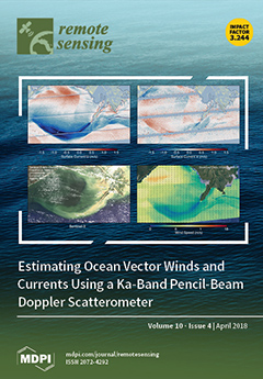
Ocean surface currents and winds are closely coupled essential climate variables and should be observed simultaneously to understand air–sea interactions. Under NASA’s Instrument Incubator Program (IIP), we have built a wide-swath Doppler scatterometer, DopplerScatt, intended to serve as an airborne prototype for a future wind and current spaceborne missions. The cover shows data collected at the outflow of the Mississippi River into Barataria Bay, where the river releases significant sediment, as shown in the lower-left Sentinel-3 image. The lower right image shows the DopplerScatt estimated neutral winds, which are noticeably modified by the currents. The upper panels show the east (left) and north (right) surface current components. In addition to the plume recirculation into Barataria Bay, one can observe a strong submesoscale front coinciding with a front in sediment concentration. View this paper.
  • Issues are regarded as officially published after their release is announced to the table of contents alert mailing list.
  • You may sign up for e-mail alerts to receive table of contents of newly released issues.
  • PDF is the official format for papers published in both, html and pdf forms. To view the papers in pdf format, click on the "PDF Full-text" link, and use the free Adobe Reader to open them.
Order results
Result details
Section
Select all
Export citation of selected articles as:

Research

Jump to: Review, Other

21 pages, 13065 KiB  
Article
Evaluating Landsat and RapidEye Data for Winter Wheat Mapping and Area Estimation in Punjab, Pakistan
by Ahmad Khan, Matthew C. Hansen, Peter V. Potapov, Bernard Adusei, Amy Pickens, Alexander Krylov and Stephen V. Stehman
Remote Sens. 2018, 10(4), 489; https://doi.org/10.3390/rs10040489 - 21 Mar 2018
Cited by 30 | Viewed by 8484
Abstract
While publicly available, cost-free coarse and medium spatial resolution satellite data such as MODIS and Landsat perform well in characterizing industrial cropping systems, commercial high spatial resolution satellite data are often preferred alternative for fine scale land tenure agricultural systems such as found [...] Read more.
While publicly available, cost-free coarse and medium spatial resolution satellite data such as MODIS and Landsat perform well in characterizing industrial cropping systems, commercial high spatial resolution satellite data are often preferred alternative for fine scale land tenure agricultural systems such as found in Pakistan. In this article, we integrated commercial 5 m spatial resolution RapidEye and free 30 m Landsat imagery in characterizing winter wheat in Punjab province, Pakistan. Specifically, we used 5 m spatial resolution RapidEye imagery from peak of the winter wheat growing season to derive training data for the characterization of time-series Landsat data. After co-registration, each RapidEye image was classified into wheat/no wheat labels at the 5 m resolution and then aggregated as percent cover to 30 m Landsat grid cells. We produced four maps, two using RapidEye derived continuous training data (of percent wheat cover) as input to a regression tree model, and two using RapidEye derived categorical training data as input to a classification tree model. From the RapidEye-derived 30 m continuous training data, we derived Map 1 as percent wheat per pixel, and Map 2 as binary wheat/no wheat classification derived using a 50% threshold applied to Map 1. To create the categorical wheat/no wheat training data, we first converted the continuous training data to a wheat/no wheat classification, and then used these categorical RapidEye training data to produce a categorical wheat map from the Landsat data. Two methods for categorizing the training data were used. The first method used a 50% wheat/no wheat threshold to produce Map 3, and the second method used only pure wheat (≥75% cover) and no wheat (≤25% cover) training pixels to produce Map 4. The approach of Map 4 is analogous to a standard method in which whole, pure, high-confidence training pixels are delineated. We validated the wheat maps with field data collected using a stratified, two-stage cluster design. Accuracy of the maps produced from the percent cover training data (Map 1 and Map 2) was not substantially better than the accuracy of the maps produced from the categorical training data as all methods yielded similar overall accuracies (±standard error): 88% (±4%) for Map 1, 90% (±4%) for Map 2, 90% (±4%) for Map 3, and 87% (±4%) for Map 4. Because the percent cover training data did not produce significantly higher accuracies, sub-pixel training data are not required for winter wheat mapping in Punjab. Given sufficient expertise in supervised classification model calibration, freely available Landsat data are sufficient for crop mapping in the fine-scale land tenure system of Punjab. For winter wheat mapping in Punjab and other like landscapes, training data for supervised classification may be collected directly from Landsat images without the need for high resolution reference imagery. Full article
(This article belongs to the Section Remote Sensing in Agriculture and Vegetation)
Show Figures

Graphical abstract

20 pages, 35474 KiB  
Article
Dust Detection and Intensity Estimation Using Himawari-8/AHI Observation
by Lu She, Yong Xue, Xihua Yang, Jie Guang, Ying Li, Yahui Che, Cheng Fan and Yanqing Xie
Remote Sens. 2018, 10(4), 490; https://doi.org/10.3390/rs10040490 - 21 Mar 2018
Cited by 46 | Viewed by 9144
Abstract
In this study, simple dust detection and intensity estimation methods using Himawari-8 Advanced Himawari Imager (AHI) data are developed. Based on the differences of thermal radiation characteristics between dust and other typical objects, brightness temperature difference (BTD) among four channels (BT11–BT [...] Read more.
In this study, simple dust detection and intensity estimation methods using Himawari-8 Advanced Himawari Imager (AHI) data are developed. Based on the differences of thermal radiation characteristics between dust and other typical objects, brightness temperature difference (BTD) among four channels (BT11–BT12, BT8–BT11, and BT3–BT11) are used together for dust detection. When considering the thermal radiation variation of dust particles over different land cover types, a dynamic threshold scheme for dust detection is adopted. An enhanced dust intensity index (EDII) is developed based on the reflectance of visible/near-infrared bands, BT of thermal-infrared bands, and aerosol optical depth (AOD), and is applied to the detected dust area. The AOD is retrieved using multiple temporal AHI observations by assuming little surface change in a short time period (i.e., 1–2 days) and proved with high accuracy using the Aerosol Robotic Network (AERONET) and cross-compared with MODIS AOD products. The dust detection results agree qualitatively with the dust locations that were revealed by AHI true color images. The results were also compared quantitatively with dust identification results from the AERONET AOD and Ångström exponent, achieving a total dust detection accuracy of 84%. A good agreement is obtained between EDII and the visibility data from National Climatic Data Center ground measurements, with a correlation coefficient of 0.81, indicating the effectiveness of EDII in dust monitoring. Full article
(This article belongs to the Section Atmospheric Remote Sensing)
Show Figures

Graphical abstract

21 pages, 6418 KiB  
Article
Estimating Sub-Pixel Soybean Fraction from Time-Series MODIS Data Using an Optimized Geographically Weighted Regression Model
by Qiong Hu, Yaxiong Ma, Baodong Xu, Qian Song, Huajun Tang and Wenbin Wu
Remote Sens. 2018, 10(4), 491; https://doi.org/10.3390/rs10040491 - 21 Mar 2018
Cited by 27 | Viewed by 5723
Abstract
Soybean cultivation in China has significantly decreased due to the rising import of genetically modified soybeans from other countries. Understanding soybean’s extent and change information is of great value for national agricultural policy implications and global food security. Some previous studies have explored [...] Read more.
Soybean cultivation in China has significantly decreased due to the rising import of genetically modified soybeans from other countries. Understanding soybean’s extent and change information is of great value for national agricultural policy implications and global food security. Some previous studies have explored the quantitative relationships between crop area and spectral variables derived from remote sensing data. However, both those linear or non-linear relationships were expressed by global regression models, which ignored the spatial non-stationarity of crop spectral signature and may limit the prediction accuracy. This study presented a geographically weighted regression model (GWR) to estimate fractional soybean at 250 m spatial resolution in Heilongjiang Province, one of the most important food production regions in China, using time-series MODIS data and high-quality calibration information derived from Landsat data. A forward stepwise optimization strategy was embedded with the GWR model to select the optimal subset of independent variables for soybeans. Normalized Difference Vegetation Index (NDVI) of Julian day 233 to 257 when soybeans are filling seed was found to be the most important temporal period for sub-pixel soybean area estimation. Our MODIS-based soybean area compared well with Landsat-based results at pixel-level. Also, there was a good agreement between the MODIS-based result and census data at county level, with the coefficient of determination (R2) of 0.80 and the root mean square error (RMSE) was 340.21 km2. Additionally, F-test results showed GWR model had better model goodness-of-fit and higher prediction accuracy than the traditional ordinary least squares (OLS) model. These promising results suggest crop spectral variations both at temporal and spatial scales should be considered when exploring its relationship with pixel-level crop acreage. The optimized GWR model by combining an automated feature selection strategy has great potential for estimating sub-pixel crop area at regional scale based on remote sensing time-series data. Full article
Show Figures

Graphical abstract

17 pages, 1870 KiB  
Article
Detecting Forest Road Wearing Course Damage Using Different Methods of Remote Sensing
by Petr Hrůza, Tomáš Mikita, Nataliya Tyagur, Zdenek Krejza, Miloš Cibulka, Andrea Procházková and Zdeněk Patočka
Remote Sens. 2018, 10(4), 492; https://doi.org/10.3390/rs10040492 - 21 Mar 2018
Cited by 29 | Viewed by 6471
Abstract
Currently, a large part of forest roads with a bituminous surface course constructed in the Czech Republic in the second half of the last century has been worn out. The aim of the study is to verify the possibility and the accuracy of [...] Read more.
Currently, a large part of forest roads with a bituminous surface course constructed in the Czech Republic in the second half of the last century has been worn out. The aim of the study is to verify the possibility and the accuracy of the road wearing course damage detected by four different remote sensing methods: close range photogrammetry, terrestrial laser scanning, mobile laser scanning and airborne laser scanning. At the beginning of verification, cross sections of the road surface were surveyed geodetically and then compared with the cross sections created in the DTMs which were acquired using the four methods mentioned above. The differences calculated between particular models and geodetic measurements show that close range photogrammetry achieved an RMSE of 0.0110 m and the RMSE of terrestrial laser scanning was 0.0243 m. Based on these results, we can conclude that these two methods are sufficient for the monitoring of the asphalt wearing course of forest roads. These methods allow precise and objective localization, size and quantification of the road damage. By contrast, mobile laser scanning with an RMSE of 0.3167 m does not reach the required precision for the damage detection of forest roads due to the vegetation that affects the precision of the measurements. Similar results are achieved by airborne laser scanning, with an RMSE of 0.1392 m. As regards the time needed, close range photogrammetry appears to be the most appropriate method for damage detection of forest roads. Full article
Show Figures

Graphical abstract

16 pages, 2517 KiB  
Article
Groundwater Depletion in the West Liaohe River Basin, China and Its Implications Revealed by GRACE and In Situ Measurements
by Yulong Zhong, Min Zhong, Wei Feng, Zizhan Zhang, Yingchun Shen and Dingcheng Wu
Remote Sens. 2018, 10(4), 493; https://doi.org/10.3390/rs10040493 - 21 Mar 2018
Cited by 104 | Viewed by 12398
Abstract
The West Liaohe River Basin (WLRB) is one of the most sensitive areas to climate change in China and an important grain production base in the Inner Mongolia Autonomous Region of China. Groundwater depletion in this region is becoming a critical issue. Here, [...] Read more.
The West Liaohe River Basin (WLRB) is one of the most sensitive areas to climate change in China and an important grain production base in the Inner Mongolia Autonomous Region of China. Groundwater depletion in this region is becoming a critical issue. Here, we used the Gravity Recovery and Climate Experiment (GRACE) satellite data and in situ well observations to estimate groundwater storage (GWS) variations and discussed the driving factors of GWS changes in the WLRB. GRACE detects a GWS decline rate of −0.92 ± 0.49 km3/yr in the WLRB during 2005–2011, consistent with the estimate from in situ observations (−0.96 ± 0.19 km3/yr). This long-term GWS depletion is attributed to reduced precipitation and extensive groundwater overexploitation in the 2000s. Long-term groundwater level observations and reconstructed total water storage variations since 1980 show favorable agreement with precipitation anomalies at interannual timescales, both of which are significantly influenced by the El Niño-Southern Oscillation (ENSO). Generally, the WLRB receives more/less precipitation during the El Niño/La Niña periods. One of the strongest El Niño events on record in 1997–1998 and a subsequent strong La Niña drastically transform the climate of WLRB into a decade-long drought period, and accelerate the groundwater depletion in the WLRB after 1998. This study demonstrates the significance of integrating satellite observations, ground-based measurements, and climatological data for interpreting regional GWS changes from a long-term perspective. Full article
(This article belongs to the Special Issue Remote Sensing of Groundwater from River Basin to Global Scales)
Show Figures

Graphical abstract

27 pages, 23538 KiB  
Article
Thaw Subsidence of a Yedoma Landscape in Northern Siberia, Measured In Situ and Estimated from TerraSAR-X Interferometry
by Sofia Antonova, Henriette Sudhaus, Tazio Strozzi, Simon Zwieback, Andreas Kääb, Birgit Heim, Moritz Langer, Niko Bornemann and Julia Boike
Remote Sens. 2018, 10(4), 494; https://doi.org/10.3390/rs10040494 - 21 Mar 2018
Cited by 89 | Viewed by 9442
Abstract
In permafrost areas, seasonal freeze-thaw cycles result in upward and downward movements of the ground. For some permafrost areas, long-term downward movements were reported during the last decade. We measured seasonal and multi-year ground movements in a yedoma region of the Lena River [...] Read more.
In permafrost areas, seasonal freeze-thaw cycles result in upward and downward movements of the ground. For some permafrost areas, long-term downward movements were reported during the last decade. We measured seasonal and multi-year ground movements in a yedoma region of the Lena River Delta, Siberia, in 2013–2017, using reference rods installed deep in the permafrost. The seasonal subsidence was 1.7 ± 1.5 cm in the cold summer of 2013 and 4.8 ± 2 cm in the warm summer of 2014. Furthermore, we measured a pronounced multi-year net subsidence of 9.3 ± 5.7 cm from spring 2013 to the end of summer 2017. Importantly, we observed a high spatial variability of subsidence of up to 6 cm across a sub-meter horizontal scale. In summer 2013, we accompanied our field measurements with Differential Synthetic Aperture Radar Interferometry (DInSAR) on repeat-pass TerraSAR-X (TSX) data from the summer of 2013 to detect summer thaw subsidence over the same study area. Interferometry was strongly affected by a fast phase coherence loss, atmospheric artifacts, and possibly the choice of reference point. A cumulative ground movement map, built from a continuous interferogram stack, did not reveal a subsidence on the upland but showed a distinct subsidence of up to 2 cm in most of the thermokarst basins. There, the spatial pattern of DInSAR-measured subsidence corresponded well with relative surface wetness identified with the near infra-red band of a high-resolution optical image. Our study suggests that (i) although X-band SAR has serious limitations for ground movement monitoring in permafrost landscapes, it can provide valuable information for specific environments like thermokarst basins, and (ii) due to the high sub-pixel spatial variability of ground movements, a validation scheme needs to be developed and implemented for future DInSAR studies in permafrost environments. Full article
(This article belongs to the Special Issue Remote Sensing of Dynamic Permafrost Regions)
Show Figures

Figure 1

31 pages, 40835 KiB  
Article
New Tropical Peatland Gas and Particulate Emissions Factors Indicate 2015 Indonesian Fires Released Far More Particulate Matter (but Less Methane) than Current Inventories Imply
by Martin J. Wooster, David. L. A. Gaveau, Mohammad A. Salim, Tianran Zhang, Weidong Xu, David C. Green, Vincent Huijnen, Daniel Murdiyarso, Dodo Gunawan, Nils Borchard, Michael Schirrmann, Bruce Main and Alpon Sepriando
Remote Sens. 2018, 10(4), 495; https://doi.org/10.3390/rs10040495 - 21 Mar 2018
Cited by 59 | Viewed by 12095
Abstract
Deforestation and draining of the peatlands in equatorial SE Asia has greatly increased their flammability, and in September–October 2015 a strong El Niño-related drought led to further drying and to widespread burning across parts of Indonesia, primarily on Kalimantan and Sumatra. These fires [...] Read more.
Deforestation and draining of the peatlands in equatorial SE Asia has greatly increased their flammability, and in September–October 2015 a strong El Niño-related drought led to further drying and to widespread burning across parts of Indonesia, primarily on Kalimantan and Sumatra. These fires resulted in some of the worst sustained outdoor air pollution ever recorded, with atmospheric particulate matter (PM) concentrations exceeding those considered “extremely hazardous to health” by up to an order of magnitude. Here we report unique in situ air quality data and tropical peatland fire emissions factors (EFs) for key carbonaceous trace gases (CO2, CH4 and CO) and PM2.5 and black carbon (BC) particulates, based on measurements conducted on Kalimantan at the height of the 2015 fires, both at locations of “pure” sub-surface peat burning and spreading vegetation fires atop burning peat. PM2.5 are the most significant smoke constituent in terms of human health impacts, and we find in situ PM2.5 emissions factors for pure peat burning to be 17.8 to 22.3 g·kg−1, and for spreading vegetation fires atop burning peat 44 to 61 g·kg−1, both far higher than past laboratory burning of tropical peat has suggested. The latter are some of the highest PM2.5 emissions factors measured worldwide. Using our peatland CO2, CH4 and CO emissions factors (1779 ± 55 g·kg−1, 238 ± 36 g·kg−1, and 7.8 ± 2.3 g·kg−1 respectively) alongside in situ measured peat carbon content (610 ± 47 g-C·kg−1) we provide a new 358 Tg (± 30%) fuel consumption estimate for the 2015 Indonesian fires, which is less than that provided by the GFEDv4.1s and GFASv1.2 global fire emissions inventories by 23% and 34% respectively, and which due to our lower EFCH4 produces far less (~3×) methane. However, our mean in situ derived EFPM2.5 for these extreme tropical peatland fires (28 ± 6 g·kg−1) is far higher than current emissions inventories assume, resulting in our total PM2.5 emissions estimate (9.1 ± 3.5 Tg) being many times higher than GFEDv4.1s, GFASv1.2 and FINNv2, despite our lower fuel consumption. We find that two thirds of the emitted PM2.5 come from Kalimantan, one third from Sumatra, and 95% from burning peatlands. Using new geostationary fire radiative power (FRP) data we map the fire emissions’ spatio-temporal variations in far greater detail than ever before (hourly, 0.05°), identifying a tropical peatland fire diurnal cycle twice as wide as in neighboring non-peat areas and peaking much later in the day. Our data show that a combination of greatly elevated PM2.5 emissions factors, large areas of simultaneous, long-duration burning, and very high peat fuel consumption per unit area made these Sept to Oct tropical peatland fires the greatest wildfire source of particulate matter globally in 2015, furthering evidence for a regional atmospheric pollution impact whose particulate matter component in particular led to millions of citizens being exposed to extremely poor levels of air quality for substantial periods. Full article
Show Figures

Graphical abstract

25 pages, 3788 KiB  
Article
Assessment of the Impact of GNSS Processing Strategies on the Long-Term Parameters of 20 Years IWV Time Series
by Zofia Baldysz, Grzegorz Nykiel, Mariusz Figurski and Andrzej Araszkiewicz
Remote Sens. 2018, 10(4), 496; https://doi.org/10.3390/rs10040496 - 21 Mar 2018
Cited by 21 | Viewed by 4961
Abstract
Advanced processing of collected global navigation satellite systems (GNSS) observations allows for the estimation of zenith tropospheric delay (ZTD), which in turn can be converted to the integrated water vapour (IWV). The proper estimation of GNSS IWV can be affected by the adopted [...] Read more.
Advanced processing of collected global navigation satellite systems (GNSS) observations allows for the estimation of zenith tropospheric delay (ZTD), which in turn can be converted to the integrated water vapour (IWV). The proper estimation of GNSS IWV can be affected by the adopted GNSS processing strategy. To verify which of its elements cause deterioration and which improve the estimated GNSS IWV, we conducted eight reprocessings of 20 years of GPS observations (01.1996–12.2015). In each of them, we applied a different mapping function, the zenith hydrostatic delay (ZHD) a priori value, the cut-off angle, software, and the positioning method. Obtained in such a way, the ZTD time series were converted to the IWV using the meteorological parameters sourced from the ERA-Interim. Then, based on them, the long-term parameters were estimated and compared to those obtained from the IWV derived from the radio sounding (RS) observations. In this paper, we analyzed long-term parameters such as IWV mean values, linear trends, and amplitudes of annual and semiannual oscillations. A comparative analysis showed, inter alia, that in terms of the investigation of the IWV linear trend the precise point positioning (PPP) method is characterized by higher accuracy than the differential one. It was also found that using the GPT2 model and the higher elevation mask brings benefits to the GNSS IWV linear trend estimation. Full article
(This article belongs to the Section Atmospheric Remote Sensing)
Show Figures

Graphical abstract

22 pages, 3977 KiB  
Article
Quality Assessment of Sea Surface Temperature from ATSRs of the Climate Change Initiative (Phase 1)
by Christoforos Tsamalis and Roger Saunders
Remote Sens. 2018, 10(4), 497; https://doi.org/10.3390/rs10040497 - 21 Mar 2018
Cited by 10 | Viewed by 5279
Abstract
Sea Surface Temperature (SST) observations from space have been made by the Along Track Scanning Radiometers (ATSRs) providing 20 years (August 1991–April 2012) of high quality data. As part of the ESA Climate Change Initiative (CCI) project, SSTs have been retrieved from the [...] Read more.
Sea Surface Temperature (SST) observations from space have been made by the Along Track Scanning Radiometers (ATSRs) providing 20 years (August 1991–April 2012) of high quality data. As part of the ESA Climate Change Initiative (CCI) project, SSTs have been retrieved from the ATSRs. Here, the quality of CCI SST (Phase 1) from ATSRs is validated against drifting buoys. Only CCI ATSR SSTs (Version 1.1) are considered, to facilitate the comparison with the precursor dataset ATSR Reprocessing for Climate (ARC). The CCI retrievals compared with drifting buoys have a median difference slightly larger than 0.1 K. The median SST difference is larger in the tropics (∼0.3 K) during the day, with the night time showing a spatially homogeneous pattern. ATSR-2 and AATSR show similar performance in terms of Robust Standard Deviation (RSD) being 0.2–0.3 K during night and about 0.1 K higher during day. On the other hand, ATSR-1 shows increasing RSD with time from 0.3 K to over 0.6 K. Triple collocation analysis has been applied for the first time on TMI/ATSR-2 observations and for daytime conditions when the wind speed is greater than 10 m/s. Both day and night results indicate that since 2004, the random uncertainty of drifting buoys and CCI AATSR is rather stable at about 0.22 K. Before 2004, drifting buoys have larger values (∼0.3 K), while ATSR-2 shows slightly lower values (∼0.2 K). The random uncertainty for AMSR-E is about 0.47 K, also rather stable with time, while as expected, the TMI has higher values of ∼0.55 K. It is shown for the first time that the AMSR-E random uncertainty changes with latitude, being ∼0.3 K in the tropics and about double this value at mid-latitudes. The SST uncertainties provided with the CCI data are slightly overestimated above 0.45 K and underestimated below 0.3 K during the day. The uncertainty model does not capture correctly the periods with instrument problems after the ATSR-1 3.7 μ m channel failed and the gyro failure of ERS-2. During the night, the uncertainties are slightly underestimated. The CCI SSTs (Phase 1) do not yet match the quality of the ARC dataset when comparing to drifting buoys. The value of the ARC median bias is closer to zero than for CCI, while the RSD is about 0.05 K lower for ARC. ARC also shows a more homogeneous geographical distribution of median bias and RSD, although the differences between the two datasets are small. The observed discrepancies between CCI and ARC during the period of ATSR-1 are unexplained given that both datasets use the same retrieval method. Full article
(This article belongs to the Special Issue Sea Surface Temperature Retrievals from Remote Sensing)
Show Figures

Figure 1

25 pages, 7834 KiB  
Article
Improving the Remote Sensing Retrieval of Phytoplankton Functional Types (PFT) Using Empirical Orthogonal Functions: A Case Study in a Coastal Upwelling Region
by Marco Correa-Ramirez, Carmen E. Morales, Ricardo Letelier, Valeria Anabalón and Samuel Hormazabal
Remote Sens. 2018, 10(4), 498; https://doi.org/10.3390/rs10040498 - 22 Mar 2018
Cited by 8 | Viewed by 6741
Abstract
An approach that improves the spectral-based PHYSAT method for identifying phytoplankton functional types (PFT) in satellite ocean-color imagery is developed and applied to one study case. This new approach, called PHYSTWO, relies on the assumption that the dominant effect of chlorophyll-a (Chl-a) in [...] Read more.
An approach that improves the spectral-based PHYSAT method for identifying phytoplankton functional types (PFT) in satellite ocean-color imagery is developed and applied to one study case. This new approach, called PHYSTWO, relies on the assumption that the dominant effect of chlorophyll-a (Chl-a) in the normalized water-leaving radiance (nLw) spectrum can be effectively isolated from the signal of accessory pigment biomarkers of different PFT by using Empirical Orthogonal Function (EOF) decomposition. PHYSTWO operates in the dimensionless plane composed by the first two EOF modes generated through the decomposition of a space–nLw matrix at seven wavelengths (412, 443, 469, 488, 531, 547, and 555 nm). PFT determination is performed using orthogonal models derived from the acceptable ranges of anomalies proposed by PHYSAT but adjusted with the available regional and global data. In applying PHYSTWO to study phytoplankton community structures in the coastal upwelling system off central Chile, we find that this method increases the accuracy of PFT identification, extends the application of this tool to waters with high Chl-a concentration, and significantly decreases (~60%) the undetermined retrievals when compared with PHYSAT. The improved accuracy of PHYSTWO and its applicability for the identification of new PFT are discussed. Full article
(This article belongs to the Special Issue Remote Sensing of Ocean Colour)
Show Figures

Graphical abstract

18 pages, 9535 KiB  
Article
Optimisation of Savannah Land Cover Characterisation with Optical and SAR Data
by Elias Symeonakis, Thomas P. Higginbottom, Kyriaki Petroulaki and Andreas Rabe
Remote Sens. 2018, 10(4), 499; https://doi.org/10.3390/rs10040499 - 22 Mar 2018
Cited by 36 | Viewed by 8069
Abstract
Accurately mapping savannah land cover at the regional scale can provide useful input to policy decision making efforts regarding, for example, bush control or overgrazing, as well as to global carbon emissions models. Recent attempts have employed Earth observation data, either from optical [...] Read more.
Accurately mapping savannah land cover at the regional scale can provide useful input to policy decision making efforts regarding, for example, bush control or overgrazing, as well as to global carbon emissions models. Recent attempts have employed Earth observation data, either from optical or radar sensors, and most commonly from the dry season when the spectral difference between woody vegetation, crops and grasses is maximised. By far the most common practice has been the use of Landsat optical bands, but some studies have also used vegetation indices or SAR data. However, conflicting reports with regards to the effectiveness of the different approaches have emerged, leaving the respective land cover mapping community with unclear methodological pathways to follow. We address this issue by employing Landsat and Advanced Land Observing Satellite Phased Array type L-band Synthetic Aperture Radar (ALOS PALSAR) data to assess the accuracy of mapping the main savannah land cover types of woody vegetation, grassland, cropland and non-vegetated land. The study area is in southern Africa, covering approximately 44,000 km2. We test the performance of 15 different models comprised of combinations of optical and radar data from the dry and wet seasons. Our results show that a number of models perform well and very similarly. The highest overall accuracy is achieved by the model that incorporates both optical and synthetic-aperture radar (SAR) data from both dry and wet seasons with an overall accuracy of 91.1% (±1.7%): this is almost a 10% improvement from using only the dry season Landsat data (81.7 ± 2.3%). The SAR-only models were capable of mapping woody cover effectively, achieving similar or lower omission and commission errors than the optical models, but other classes were detected with lower accuracies. Our main conclusion is that the combination of metrics from different sensors and seasons improves results and should be the preferred methodological pathway for accurate savannah land cover mapping, especially now with the availability of Sentinel-1 and Sentinel-2 data. Our findings can provide much needed assistance to land cover monitoring efforts to savannahs in general, and in particular to southern African savannahs, where a number of land cover change processes have been related with the observed land degradation in the region. Full article
(This article belongs to the Section Remote Sensing Image Processing)
Show Figures

Graphical abstract

25 pages, 24874 KiB  
Article
An Objective Assessment of Hyperspectral Indicators for the Detection of Buried Archaeological Relics
by Daniele Cerra, Athos Agapiou, Rosa Maria Cavalli and Apostolos Sarris
Remote Sens. 2018, 10(4), 500; https://doi.org/10.3390/rs10040500 - 22 Mar 2018
Cited by 41 | Viewed by 8609
Abstract
Hyperspectral images can highlight crop marks in vegetated areas, which may indicate the presence of underground buried structures, by exploiting the spectral information conveyed in reflected solar radiation. In recent years, different vegetation indices and several other image features have been used, with [...] Read more.
Hyperspectral images can highlight crop marks in vegetated areas, which may indicate the presence of underground buried structures, by exploiting the spectral information conveyed in reflected solar radiation. In recent years, different vegetation indices and several other image features have been used, with varying success, to improve the interpretation of remotely sensed images for archaeological research. However, it is difficult to assess the derived maps quantitatively and select the most meaningful one for a given task, in particular for a non-specialist in image processing. This paper estimates for the first time objectively the suitability of maps derived from spectral features for the detection of buried archaeological structures in vegetated areas based on information theory. This is achieved by computing the statistical dependence between the extracted features and a digital map indicating the presence of buried structures using information theoretical notions. Based on the obtained scores on known targets, the features can be ranked and the most suitable can be chosen to aid in the discovery of previously undetected crop marks in the area under similar conditions. Three case studies are reported: the Roman buried remains of Carnuntum (Austria), the underground structures of Selinunte in the South of Italy, and the buried street relics of Pherai (Velestino) in central Greece. Full article
(This article belongs to the Special Issue Advances in Remote Sensing for Archaeological Heritage)
Show Figures

Graphical abstract

16 pages, 5495 KiB  
Article
SAR Automatic Target Recognition Using a Roto-Translational Invariant Wavelet-Scattering Convolution Network
by Haipeng Wang, Suo Li, Yu Zhou and Sizhe Chen
Remote Sens. 2018, 10(4), 501; https://doi.org/10.3390/rs10040501 - 22 Mar 2018
Cited by 30 | Viewed by 7465
Abstract
The algorithm of synthetic aperture radar (SAR) for automatic target recognition consists of two stages: feature extraction and classification. The quality of extracted features has significant impacts on the final classification performance. This paper presents a SAR automatic target classification method based on [...] Read more.
The algorithm of synthetic aperture radar (SAR) for automatic target recognition consists of two stages: feature extraction and classification. The quality of extracted features has significant impacts on the final classification performance. This paper presents a SAR automatic target classification method based on the wavelet-scattering convolution network. By introducing a deep scattering convolution network with complex wavelet filters over spatial and angular variables, robust feature representations can be extracted across various scales and angles without training data. Conventional dimension reduction and a support vector machine classifier are followed to complete the classification task. The proposed method is then tested on the moving and stationary target acquisition and recognition (MSTAR) benchmark data set and achieves an average accuracy of 97.63% on the classification of ten-class targets without data augmentation. Full article
(This article belongs to the Special Issue Analysis of Big Data in Remote Sensing)
Show Figures

Graphical abstract

17 pages, 7863 KiB  
Article
An Approach for High-Resolution Mapping of Hawaiian Metrosideros Forest Mortality Using Laser-Guided Imaging Spectroscopy
by Nicholas R. Vaughn, Gregory P. Asner, Philip G. Brodrick, Roberta E. Martin, Joseph W. Heckler, David E. Knapp and R. Flint Hughes
Remote Sens. 2018, 10(4), 502; https://doi.org/10.3390/rs10040502 - 22 Mar 2018
Cited by 31 | Viewed by 7528
Abstract
Rapid ‘Ōhi‘a Death (ROD) is a disease aggressively killing large numbers of Metrosideros polymorpha (‘ōhi‘a), a native keystone tree species on Hawaii Island. This loss threatens to deeply alter the biological make-up of this unique island ecosystem. Spatially explicit information about the present [...] Read more.
Rapid ‘Ōhi‘a Death (ROD) is a disease aggressively killing large numbers of Metrosideros polymorpha (‘ōhi‘a), a native keystone tree species on Hawaii Island. This loss threatens to deeply alter the biological make-up of this unique island ecosystem. Spatially explicit information about the present and past advancement of the disease is essential for its containment; yet, currently such data are severely lacking. To this end, we used the Carnegie Airborne Observatory to collect Laser-Guided Imaging Spectroscopy data and high-resolution digital imagery across >500,000 ha of Hawaii Island in June–July 2017. We then developed a method to map individual tree crowns matching the symptoms of both active (brown; desiccated ‘ōhi‘a crowns) and past (leafless tree crowns) ROD infection using an ensemble of two distinct machine learning approaches. Employing a very conservative classification scheme for minimizing false-positives, model sensitivity rates were 86.9 and 82.5, and precision rates were 97.4 and 95.3 for browning and leafless crowns, respectively. Across the island of Hawaii, we found 43,134 individual crowns suspected of exhibiting the active (browning) stage of ROD infection. Hotspots of potential ROD infection are apparent in the maps. The peninsula on the eastern side of Hawaii known as the Puna district, where the ROD outbreak likely originated, contained a particularly high density of brown crown detections. In comparison, leafless crown detections were much more numerous (547,666 detected leafless crowns in total) and more dispersed across the island. Mapped hotspots of likely ROD incidence across the island will enable scientists, administrators, and land managers to better understand both where and how ROD spreads and how to apply limited resources to limiting this spread. Full article
(This article belongs to the Special Issue Remote Sensing of Tropical Forest Biodiversity)
Show Figures

Figure 1

19 pages, 42056 KiB  
Article
A New Strategy for Extracting ENSO Related Signals in the Troposphere and Lower Stratosphere from GNSS RO Specific Humidity Observations
by Zhiping Chen, Jiancheng Li, Jia Luo and Xinyun Cao
Remote Sens. 2018, 10(4), 503; https://doi.org/10.3390/rs10040503 - 22 Mar 2018
Cited by 28 | Viewed by 6376
Abstract
El Niño-Southern Oscillation related signals (ENSORS) in the troposphere and lower stratosphere (TLS) are the prominent source of inter-annual variability in the weather and climate system of the Earth, and are especially important for monitoring El Niño-Southern Oscillation (ENSO). In order to reduce [...] Read more.
El Niño-Southern Oscillation related signals (ENSORS) in the troposphere and lower stratosphere (TLS) are the prominent source of inter-annual variability in the weather and climate system of the Earth, and are especially important for monitoring El Niño-Southern Oscillation (ENSO). In order to reduce the influence of quasi-biennial oscillations and other unknown signals compared with the traditional empirical orthogonal functions (EOF) method, a new processing strategy involving fusion of a low-pass filter with an optimal filtering frequency (hereafter called the optimal low-pass filter) and EOF is proposed in this paper for the extraction of ENSORS in the TLS. Using this strategy, ENSORS in the TLS over different areas were extracted effectively from the specific humidity profiles provided by the Global Navigation Satellite System (GNSS) radio occultation (RO) of the Constellation Observing System for Meteorology, Ionosphere, and Climate (COSMIC) mission from June 2006 to June 2014. The spatial and temporal responses of the extracted ENSORS to ENSO at different altitudes in the TLS were analyzed. The results show that the most suitable areas for extracting ENSORS are over the areas of G25 (−25°S–25°N, 180°W–180°E) −G65(−65°S–65°N, 180°W–180°E) in the upper troposphere (250–200 hpa) which show a lag time of 3 months relative to the Oceanic Niño index (ONI). In the troposphere, ENSO manifests as a major inter-annual variation. The ENSORS extracted from the N3.4 (−5°S to 5°N, 120°W to 170°W) area are responsible for 83.59% of the variability of the total specific humidity anomaly (TSHA) at an altitude of 250 hpa. Over all other defined areas which contain the N3.4 areas, ENSORS also explain the major variability in TSHA. In the lower stratosphere, the extracted ENSORS present an unstable pattern at different altitudes because of the weak ENSO effect. Moreover, the spatial and temporal responses of ENSORS and ONI to ENSO across the globe are in good agreement. Over the areas with strong correlation between ENSORS and ONI, the larger the correlation coefficient is, the shorter the lag time between them. Furthermore, the ENSORS from zonal-mean specific humidity monthly anomalies at different altitudes can clearly present the vertical structure of ENSO in the troposphere. This study provides a new approach for monitoring ENSO events. Full article
Show Figures

Figure 1

18 pages, 2641 KiB  
Article
SAR Image Recognition with Monogenic Scale Selection-Based Weighted Multi-task Joint Sparse Representation
by Zhi Zhou, Ming Wang, Zongjie Cao and Yiming Pi
Remote Sens. 2018, 10(4), 504; https://doi.org/10.3390/rs10040504 - 22 Mar 2018
Cited by 17 | Viewed by 3923
Abstract
The monogenic signal, which is defined as a linear combination of a signal and its Riesz-transformed one, provides a great opportunity for synthetic aperture radar (SAR) image recognition. However, the incredibly large number of components at different scales may result in too much [...] Read more.
The monogenic signal, which is defined as a linear combination of a signal and its Riesz-transformed one, provides a great opportunity for synthetic aperture radar (SAR) image recognition. However, the incredibly large number of components at different scales may result in too much of a burden for onboard computation. There is great information redundancy in monogenic signals because components at some scales are less discriminative or even have negative impact on classification. In addition, the heterogeneity of the three types of components will lower the quality of decision-making. To solve the problems above, a scale selection method, based on a weighted multi-task joint sparse representation, is proposed. A scale selection model is designed and the Fisher score is presented to measure the discriminative ability of components at each scale. The components with high Fisher scores are concatenated to three component-specific features, and an overcomplete dictionary is built. Meanwhile, the scale selection model produces the weight vector. The three component-specific features are then fed into a multi-task joint sparse representation classification framework. The final decision is made in terms of accumulated weighted reconstruction error. Experiments on the Moving and Stationary Target Acquisition and Recognition (MSTAR) dataset have proved the effectiveness and superiority of our method. Full article
(This article belongs to the Section Remote Sensing Image Processing)
Show Figures

Graphical abstract

17 pages, 5750 KiB  
Article
Evaluating the Applications of the Near-Infrared Region in Mapping Foliar N in the Miombo Woodlands
by Godfrey Mutowo, Onisimo Mutanga and Mhosisi Masocha
Remote Sens. 2018, 10(4), 505; https://doi.org/10.3390/rs10040505 - 23 Mar 2018
Cited by 12 | Viewed by 4472
Abstract
Remote sensing has been widely used to estimate the distribution of foliar nitrogen (N) in a cost-effective manner. Although hyperspectral remote sensing targeting the red edge and shortwave infrared regions has proved successful at estimating foliar N, research has recently shifted to include [...] Read more.
Remote sensing has been widely used to estimate the distribution of foliar nitrogen (N) in a cost-effective manner. Although hyperspectral remote sensing targeting the red edge and shortwave infrared regions has proved successful at estimating foliar N, research has recently shifted to include exploring the benefits of using the near-infrared (NIR) region, especially when using broadband sensing. Bootstrapped random forest regression analysis was applied on Sentinel 2 data to test the significance of using the NIR in foliar N estimation in miombo woodlands. The results revealed a low ranking for individual NIR bands, but the ranking improved when spectral indices were used. In addition, the results indicated a marginal increase in the normalised root mean square error of prediction (nRMSE) from 11.35% N when all bands were used to 11.69% N when the NIR bands were excluded from the model. Bootstrapping results show higher accuracy and better consistency in the prediction of foliar N using combined spectral indices and individual bands. This study therefore underscores the significance of spectral indices to increase the NIR region’s importance in estimating the distribution of foliar N as a key indicator of ecosystem health at the landscape scale in miombo systems. Full article
Show Figures

Graphical abstract

17 pages, 17013 KiB  
Article
Reducing Uncertainties in Applying Remotely Sensed Land Use and Land Cover Maps in Land-Atmosphere Interaction: Identifying Change in Space and Time
by Yaqian He, Timothy A. Warner, Brenden E. McNeil and Eungul Lee
Remote Sens. 2018, 10(4), 506; https://doi.org/10.3390/rs10040506 - 23 Mar 2018
Cited by 15 | Viewed by 5654
Abstract
Land use and land cover (LULC) data are a central component of most land-atmosphere interaction studies, but there are two common and highly problematic scale mismatches between LULC and climate data. First, in the spatial domain, researchers rarely consider the impact of scaling [...] Read more.
Land use and land cover (LULC) data are a central component of most land-atmosphere interaction studies, but there are two common and highly problematic scale mismatches between LULC and climate data. First, in the spatial domain, researchers rarely consider the impact of scaling up fine-scale LULC data to match coarse-scale climate datasets. Second, in the temporal domain, climate data typically have sub-daily, daily, monthly, or annual resolution, but LULC datasets often have much coarser (e.g., decadal) resolution. We first explored the effect of three spatial scaling methods on correlations among LULC data and a land surface climatic variable, latent heat flux in China. Scaling by a fractional method preserved significant correlations among LULC data and latent heat flux at all three studied scales (0.5°, 1.0°, and 2.5°), whereas nearest-neighbor and majority-aggregation methods caused these correlations to diminish and even become statistically non-significant at coarser spatial scales (i.e., 2.5°). In the temporal domain, we identified fractional changes in croplands, forests, and grasslands in China using a recently developed and annually resolved time series of LULC maps from 1982 to 2012. Relative to common LULC change (LULCC) analyses conducted over two-time steps or several time periods, this annually resolved, 31-year time series of LULC maps enables robust interpretation of LULCC. Specifically, the annual resolution of these data enabled us to more precisely observe three key and statistically significant LULCC trends and transitions that could have consequential effects on land-atmosphere interaction: (1) decreasing grasslands to increasing croplands in the Northeast China plain and the Yellow river basin, (2) decreasing croplands to increasing forests in the Yangtze river basin, and (3) decreasing grasslands to increasing forests in Southwest China. Our study not only demonstrates the importance of using a fractional spatial rescaling method, but also illustrates the value of annually resolved LULC time series for detecting significant trends and transitions in LULCC, thus potentially facilitating a more robust use of remotely sensed data in land-atmosphere interaction studies. Full article
(This article belongs to the Special Issue Remote Sensing of Land-Atmosphere Interactions)
Show Figures

Graphical abstract

19 pages, 4601 KiB  
Article
HY-2A Altimeter Data Initial Assessment and Corresponding Two-Pass Waveform Retracker
by Shengjun Zhang, Jiancheng Li, Taoyong Jin and Defu Che
Remote Sens. 2018, 10(4), 507; https://doi.org/10.3390/rs10040507 - 23 Mar 2018
Cited by 20 | Viewed by 5673
Abstract
The accuracy and resolution of the marine gravity field derived from multisatellite altimeter data sets mainly depend on the corresponding range precision and spatial distribution. Here, we preliminarily investigate the performance of HY-2A altimeter data by analyzing cross-mission sea surface height discrepancies with [...] Read more.
The accuracy and resolution of the marine gravity field derived from multisatellite altimeter data sets mainly depend on the corresponding range precision and spatial distribution. Here, we preliminarily investigate the performance of HY-2A altimeter data by analyzing cross-mission sea surface height discrepancies with SARAL/AltiKa and calculating correlation coefficients with respect to tide gauge measurements. We also explore the improved range precision that can be achieved using a two-pass weighted least squares retracker which was proposed for the purpose of optimal gravity field recovery. Firstly, both the exact repetitive mission and the geodetic mission for HY-2A provide new track orientations and different data coverage for recovering the marine gravity field, and these dense geographical distributions are more greatly attributed to the geodetic mission in recent years. Secondly, HY-2A provides reliable sea surface height measurements based on exterior verifications by SARAL/AltiKa geophysical data records and tide gauge measurements, although the accuracy level is slightly lower than SARAL/AltiKa. Another more exciting finding is that the statistics of along-track sea surface heights in one-second intervals show that the two-pass retracking does further improve the range precision by a factor of 1.6 with respect to 20 Hz retracked results in sensor data records. In conclusion, the HY-2A mission can substantially improve the global accuracy and resolution of the marine gravity field and will reveal new tectonic features such as microplates, abyssal hill fabric, and new uncharted seamounts on the ocean floor. Full article
(This article belongs to the Special Issue Satellite Altimetry for Earth Sciences)
Show Figures

Graphical abstract

14 pages, 70088 KiB  
Article
Modeling Orbital Error in InSAR Interferogram Using Frequency and Spatial Domain Based Methods
by Xin Tian, Rakesh Malhotra, Bing Xu, Haoping Qi and Yuxiao Ma
Remote Sens. 2018, 10(4), 508; https://doi.org/10.3390/rs10040508 - 23 Mar 2018
Cited by 18 | Viewed by 7541
Abstract
Synthetic Aperture Radar Interferometry (SAR, InSAR) is increasingly being used for deformation monitoring. Uncertainty in satellite state vectors is considered to be one of the main sources of errors in applications such as this. In this paper, we present frequency and spatial domain [...] Read more.
Synthetic Aperture Radar Interferometry (SAR, InSAR) is increasingly being used for deformation monitoring. Uncertainty in satellite state vectors is considered to be one of the main sources of errors in applications such as this. In this paper, we present frequency and spatial domain based algorithms to model orbital errors in InSAR interferograms. The main advantage of this method, when applied to the spatial domain, is that the order of the polynomial coefficient is automatically determined according to the features of the orbital errors, using K-cross validation. In the frequency domain, a maximum likelihood fringe rate estimate is deployed to resolve linear orbital patterns in strong noise interferograms, where spatial-domain-based algorithms are unworkable. Both methods were tested and compared with synthetic data and applied to historical Environmental Satellite Advanced Synthetic Aperture Radar (ENVISAT ASAR) sensor and modern instruments such as Gaofen-3 (GF-3) and Sentinel-1. The validation from the simulation demonstrated that an accuracy of ~1mm can be obtained under optimal conditions. Using an independent GPS measurement that is discontinuous from the InSAR measurement over the Tohoku-Oki area, we found a 31.45% and 73.22% reduction in uncertainty after applying our method for ASAR tracks 347 and 74, respectively. Full article
(This article belongs to the Special Issue Advances in SAR: Sensors, Methodologies, and Applications)
Show Figures

Graphical abstract

32 pages, 48136 KiB  
Article
An Automatic Sparse Pruning Endmember Extraction Algorithm with a Combined Minimum Volume and Deviation Constraint
by Huali Li, Jun Liu and Haicong Yu
Remote Sens. 2018, 10(4), 509; https://doi.org/10.3390/rs10040509 - 23 Mar 2018
Cited by 6 | Viewed by 3627
Abstract
In this paper, an automatic sparse pruning endmember extraction algorithm with a combined minimum volume and deviation constraint (SPEEVD) is proposed. The proposed algorithm can adaptively determine the number of endmembers through a sparse pruning method and, at the same time, can weaken [...] Read more.
In this paper, an automatic sparse pruning endmember extraction algorithm with a combined minimum volume and deviation constraint (SPEEVD) is proposed. The proposed algorithm can adaptively determine the number of endmembers through a sparse pruning method and, at the same time, can weaken the noise interference by a minimum volume and deviation constraint. A non-negative matrix factorization solution based on the projection gradient is mathematically applied to solve the combined constrained optimization problem, which makes sure that the convergence is steady and robust. Experiments were carried out on both simulated data sets and real AVIRIS data sets. The experimental results indicate that the proposed method does not require a predetermined endmember number, but it still manifests an improvement in both the root-mean-square error (RMSE) and the endmember spectra, compared to the other state-of-the-art methods, most of which need an accurate pre-estimation of endmember number. Full article
(This article belongs to the Section Remote Sensing Image Processing)
Show Figures

Graphical abstract

22 pages, 64596 KiB  
Article
Total Variation Regularization Term-Based Low-Rank and Sparse Matrix Representation Model for Infrared Moving Target Tracking
by Minjie Wan, Guohua Gu, Weixian Qian, Kan Ren, Qian Chen, Hai Zhang and Xavier Maldague
Remote Sens. 2018, 10(4), 510; https://doi.org/10.3390/rs10040510 - 24 Mar 2018
Cited by 35 | Viewed by 5723
Abstract
Infrared moving target tracking plays a fundamental role in many burgeoning research areas of Smart City. Challenges in developing a suitable tracker for infrared images are particularly caused by pose variation, occlusion, and noise. In order to overcome these adverse interferences, a total [...] Read more.
Infrared moving target tracking plays a fundamental role in many burgeoning research areas of Smart City. Challenges in developing a suitable tracker for infrared images are particularly caused by pose variation, occlusion, and noise. In order to overcome these adverse interferences, a total variation regularization term-based low-rank and sparse matrix representation (TV-LRSMR) model is designed in order to exploit a robust infrared moving target tracker in this paper. First of all, the observation matrix that is derived from the infrared sequence is decomposed into a low-rank target matrix and a sparse occlusion matrix. For the purpose of preventing the noise pixel from being separated into the occlusion term, a total variation regularization term is proposed to further constrain the occlusion matrix. Then an alternating algorithm combing principal component analysis and accelerated proximal gradient methods is employed to separately optimize the two matrices. For long-term tracking, the presented algorithm is implemented using a Bayesien state inference under the particle filtering framework along with a dynamic model update mechanism. Both qualitative and quantitative experiments that were examined on real infrared video sequences verify that our algorithm outperforms other state-of-the-art methods in terms of precision rate and success rate. Full article
Show Figures

Graphical abstract

20 pages, 2726 KiB  
Article
Automatic Ship Classification from Optical Aerial Images with Convolutional Neural Networks
by Antonio-Javier Gallego, Antonio Pertusa and Pablo Gil
Remote Sens. 2018, 10(4), 511; https://doi.org/10.3390/rs10040511 - 24 Mar 2018
Cited by 155 | Viewed by 14145
Abstract
The automatic classification of ships from aerial images is a considerable challenge. Previous works have usually applied image processing and computer vision techniques to extract meaningful features from visible spectrum images in order to use them as the input for traditional supervised classifiers. [...] Read more.
The automatic classification of ships from aerial images is a considerable challenge. Previous works have usually applied image processing and computer vision techniques to extract meaningful features from visible spectrum images in order to use them as the input for traditional supervised classifiers. We present a method for determining if an aerial image of visible spectrum contains a ship or not. The proposed architecture is based on Convolutional Neural Networks (CNN), and it combines neural codes extracted from a CNN with a k-Nearest Neighbor method so as to improve performance. The kNN results are compared to those obtained with the CNN Softmax output. Several CNN models have been configured and evaluated in order to seek the best hyperparameters, and the most suitable setting for this task was found by using transfer learning at different levels. A new dataset (named MASATI) composed of aerial imagery with more than 6000 samples has also been created to train and evaluate our architecture. The experimentation shows a success rate of over 99% for our approach, in contrast with the 79% obtained with traditional methods in classification of ship images, also outperforming other methods based on CNNs. A dataset of images (MWPU VHR-10) used in previous works was additionally used to evaluate the proposed approach. Our best setup achieves a success ratio of 86% with these data, significantly outperforming previous state-of-the-art ship classification methods. Full article
(This article belongs to the Section Remote Sensing Image Processing)
Show Figures

Graphical abstract

18 pages, 92901 KiB  
Article
Focal Mechanisms of the 2016 Central Italy Earthquake Sequence Inferred from High-Rate GPS and Broadband Seismic Waveforms
by Shuhan Zhong, Caijun Xu, Lei Yi and Yanyan Li
Remote Sens. 2018, 10(4), 512; https://doi.org/10.3390/rs10040512 - 25 Mar 2018
Cited by 18 | Viewed by 6994
Abstract
Numerous shallow earthquakes, including a multitude of small shocks and three moderate mainshocks, i.e., the Amatrice earthquake on 24 August, the Visso earthquake on 26 October and the Norcia earthquake on 30 October, occurred throughout central Italy in late 2016 and resulted in [...] Read more.
Numerous shallow earthquakes, including a multitude of small shocks and three moderate mainshocks, i.e., the Amatrice earthquake on 24 August, the Visso earthquake on 26 October and the Norcia earthquake on 30 October, occurred throughout central Italy in late 2016 and resulted in many casualties and property losses. The three mainshocks were successfully recorded by high-rate Global Positioning System (GPS) receivers located near the epicenters, while the broadband seismograms in this area were mostly clipped due to the strong shaking. We retrieved the dynamic displacements from these high-rate GPS records using kinematic precise point positioning analysis. The focal mechanisms of the three mainshocks were estimated both individually and jointly using high-rate GPS waveforms in a very small epicentral distance range (<100 km) and unclipped regional broadband waveforms (100~600 km). The results show that the moment magnitudes of the Amatrice, Visso, and Norcia events are Mw 6.1, Mw 5.9, and Mw 6.5, respectively. Their focal mechanisms are dominated by normal faulting, which is consistent with the local tectonic environment. The moment tensor solution for the Norcia earthquake demonstrates a significant non-double-couple component, which suggests that the faulting interface is complicated. Sparse network tests were conducted to retrieve stable focal mechanisms using a limited number of GPS records. Our results confirm that high-rate GPS waveforms can act as a complement to clipped near-field long-period seismic waveform signals caused by the strong motion and can effectively constrain the focal mechanisms of moderate- to large-magnitude earthquakes. Thus, high-rate GPS observations extremely close to the epicenter can be utilized to rapidly obtain focal mechanisms, which is critical for earthquake emergency response operations. Full article
Show Figures

Graphical abstract

20 pages, 34321 KiB  
Article
Evaluating Different Methods for Estimating Diameter at Breast Height from Terrestrial Laser Scanning
by Chang Liu, Yanqiu Xing, Jialong Duanmu and Xin Tian
Remote Sens. 2018, 10(4), 513; https://doi.org/10.3390/rs10040513 - 25 Mar 2018
Cited by 48 | Viewed by 6769
Abstract
The accurate measurement of diameter at breast height (DBH) is essential to forest operational management, forest inventory, and carbon cycle modeling. Terrestrial laser scanning (TLS) is a measurement technique that allows rapid, automatic, and periodical estimates of DBH information. With the multitude of [...] Read more.
The accurate measurement of diameter at breast height (DBH) is essential to forest operational management, forest inventory, and carbon cycle modeling. Terrestrial laser scanning (TLS) is a measurement technique that allows rapid, automatic, and periodical estimates of DBH information. With the multitude of DBH estimation approaches available, a systematic study is needed to compare different algorithms and evaluate the ideal situations to use a specific algorithm. To contribute to such an approach, this study evaluated three commonly used DBH estimation algorithms: Hough-transform, linear least square circle fitting, and nonlinear least square circle fitting. They were each evaluated on their performance using two forest types of TLS data under numerous preprocessing conditions. The two forest types were natural secondary forest and plantation. The influences of preprocessing conditions on the performance of the algorithms were also investigated. Results showed that among the three algorithms, the linear least square circle fitting algorithm was the most appropriate for the natural secondary forest, and the nonlinear least square circle fitting algorithm was the most appropriate for the plantation. In the natural secondary forest, a moderate gray scale threshold of three and a slightly large height bin of 0.24 m were the optimal parameters for the appropriate algorithm of the multi-scan scanning method, and a moderate gray scale threshold of three and a large height bin of 1.34 m were the optimal parameters for the appropriate algorithm of the single-scan scanning method. A small gray scale threshold of one and a small height bin of 0.1 m were the optimal parameters for the appropriate algorithm of the single-scan scanning method in the plantation. Full article
(This article belongs to the Special Issue Lidar for Forest Science and Management)
Show Figures

Figure 1

17 pages, 19525 KiB  
Article
Wind Gust Detection and Impact Prediction for Wind Turbines
by Kai Zhou, Nihanth Cherukuru, Xiaoyu Sun and Ronald Calhoun
Remote Sens. 2018, 10(4), 514; https://doi.org/10.3390/rs10040514 - 25 Mar 2018
Cited by 20 | Viewed by 7859
Abstract
Wind gusts on a scale from 100 m to 1000 m are studied due to their significant influence on wind turbine performance. A detecting and tracking algorithm is proposed to extract gusts from a wind field and track their movement. The algorithm utilizes [...] Read more.
Wind gusts on a scale from 100 m to 1000 m are studied due to their significant influence on wind turbine performance. A detecting and tracking algorithm is proposed to extract gusts from a wind field and track their movement. The algorithm utilizes the “peak over threshold method,” Moore-Neighbor tracing algorithm, and Taylor’s frozen turbulence hypothesis. The algorithm was implemented for a three-hour, two-dimensional wind field retrieved from the measurements of a coherent Doppler lidar. The Gaussian shape distribution of the gust spanwise deviation from the streamline was demonstrated. Size dependency of gust deviations is discussed, and an empirical power function is derived. A prediction model estimating the impact of gusts with respect to arrival time and the probability of arrival locations is introduced, in which the Gaussian plume model and random walk theory including size dependency are applied. The prediction model was tested and the results reveal that the prediction model can represent the spanwise deviation of the gusts and capture the effect of gust size. The prediction model was applied to a virtual wind turbine array, and estimates are given for which wind turbines would be impacted. Full article
(This article belongs to the Special Issue Remote Sensing of Atmospheric Conditions for Wind Energy Applications)
Show Figures

Figure 1

18 pages, 2009 KiB  
Article
Semi-Supervised Classification of Hyperspectral Images Based on Extended Label Propagation and Rolling Guidance Filtering
by Binge Cui, Xiaoyun Xie, Siyuan Hao, Jiandi Cui and Yan Lu
Remote Sens. 2018, 10(4), 515; https://doi.org/10.3390/rs10040515 - 25 Mar 2018
Cited by 37 | Viewed by 6124
Abstract
Semi-supervised classification methods result in higher performance for hyperspectral images, because they can utilize the relationship between unlabeled samples and labeled samples to obtain pseudo-labeled samples. However, how generating an effective training sample set is a major challenge for semi-supervised methods, In this [...] Read more.
Semi-supervised classification methods result in higher performance for hyperspectral images, because they can utilize the relationship between unlabeled samples and labeled samples to obtain pseudo-labeled samples. However, how generating an effective training sample set is a major challenge for semi-supervised methods, In this paper, we propose a novel semi-supervised classification method based on extended label propagation (ELP) and a rolling guidance filter (RGF) called ELP-RGF, in which ELP is a new two-step process to make full use of unlabeled samples. The first step is to implement the graph-based label propagation algorithm to propagate the label information from labeled samples to the neighboring unlabeled samples. This is then followed by the second step, which uses superpixel propagation to assign the same labels to all pixels within the superpixels that are generated by the image segmentation method, so that some labels wrongly labeled by the above step can be modified. As a result, so obtained pseudo-labeled samples could be used to improve the performance of the classifier. Subsequently, an effective feature extraction method, i.e., RGF is further used to remove the noise and the small texture structures to optimize the features of the initial hyperspectral image. Finally, these produced initial labeled samples and high-confidence pseudo-labeled samples are used as a training set for support vector machine (SVM). The experimental results show that the proposed method can produce better classification performance for three widely-used real hyperspectral datasets, particularly when the number of training samples is relatively small. Full article
(This article belongs to the Special Issue Hyperspectral Imaging and Applications)
Show Figures

Graphical abstract

20 pages, 1902 KiB  
Article
A Deep Pipelined Implementation of Hyperspectral Target Detection Algorithm on FPGA Using HLS
by Jie Lei, Yunsong Li, Dongsheng Zhao, Jing Xie, Chein-I Chang, Lingyun Wu, Xuepeng Li, Jintao Zhang and Wenguang Li
Remote Sens. 2018, 10(4), 516; https://doi.org/10.3390/rs10040516 - 25 Mar 2018
Cited by 17 | Viewed by 6148
Abstract
Real-time target detection for hyperspectral images (HSI) has received considerable interest in recent years. However, owing to enormous data volume provided by HSI, detection algorithms are generally computationally complex, thus developing rapid processing techniques for target detection has encountered several challenging issues. It [...] Read more.
Real-time target detection for hyperspectral images (HSI) has received considerable interest in recent years. However, owing to enormous data volume provided by HSI, detection algorithms are generally computationally complex, thus developing rapid processing techniques for target detection has encountered several challenging issues. It seems that using a deep pipelined structure can improve the detection speed, and implementing on field programmable gate arrays (FPGAs) can also achieve concurrent operations rather than run streams of sequential instruction. This paper presents a deep pipelined background statistics (DPBS) approach to optimizing and implementing a well-known subpixel target detection algorithm, called constrained energy minimization (CEM) on FPGA by using high-level synthesis (HLS). This approach offers significant benefits in terms of increasing data throughput and improving design efficiency. To overcome a drawback of HLS on implementing a task-level pipelined circuit that includes a feedback data path, a script based circuit design method is further developed to make connections between some of the modules created by HLS. Experimental results show that the proposed method can detect targets on a real-hyperspectral data set (HyMap Data) only in 0.15 s without compromising detection accuracy. Full article
(This article belongs to the Special Issue Hyperspectral Imaging and Applications)
Show Figures

Graphical abstract

19 pages, 7789 KiB  
Article
Monitoring Quarry Area with Landsat Long Time-Series for Socioeconomic Study
by Haoteng Zhao, Yong Ma, Fu Chen, Jianbo Liu, Liyuan Jiang, Wutao Yao and Jin Yang
Remote Sens. 2018, 10(4), 517; https://doi.org/10.3390/rs10040517 - 26 Mar 2018
Cited by 12 | Viewed by 7921
Abstract
Quarry sites result from human activity, which includes the removal of original vegetation and the overlying soil to dig out stones for building use. Therefore, the dynamics of the quarry area provide a unique view of human mining activities. Actually, the topographic changes [...] Read more.
Quarry sites result from human activity, which includes the removal of original vegetation and the overlying soil to dig out stones for building use. Therefore, the dynamics of the quarry area provide a unique view of human mining activities. Actually, the topographic changes caused by mining activities are also a result of the development of the local economy. Thus, monitoring the quarry area can provide information about the policies of the economy and environmental protection. In this paper, we developed a combined method of machine learning classification and quarry region analysis to estimate the quarry area in a quarry region near Beijing. A temporal smoothing based on the classification results of all years was applied in post-processing to remove outliers and obtain gently changing sequences along the monitoring term. The method was applied to Landsat images to derive a quarry distribution map and quarry area time series from 1984 to 2017, revealing significant inter-annual variability. The time series revealed a five-stage development of the quarry area with different growth patterns. As the study region lies on two jurisdictions—Tianjin and Hebei—a comparison of the quarry area changes in the two jurisdictions was applied, which revealed that the different policies in the two regions could impose different impacts on the development of a quarry area. An analysis concerning the relationship between quarry area and gross regional product (GRP) was performed to explore the potential application on socioeconomic studies, and we found a strong positive correlation between quarry area and GRP in Langfang City, Hebei Province. These results demonstrate the potential benefit of annual monitoring over the long-term for socioeconomic studies, which can be used for mining decision making. Full article
(This article belongs to the Special Issue Analysis of Multi-temporal Remote Sensing Images)
Show Figures

Graphical abstract

17 pages, 54667 KiB  
Article
Haze Optical Properties from Long-Term Ground-Based Remote Sensing over Beijing and Xuzhou, China
by Kai Qin, Luyao Wang, Jian Xu, Husi Letu, Kefei Zhang, Ding Li, Jiaheng Zou and Wenzhi Fan
Remote Sens. 2018, 10(4), 518; https://doi.org/10.3390/rs10040518 - 26 Mar 2018
Cited by 22 | Viewed by 6420
Abstract
Aerosol haze pollution has had a significant impact on both global climate and the regional air quality of Eastern China, which has a high proportion of high level pollution days. Statistical analyses of aerosol optical properties and direct radiative forcing at two AERONET [...] Read more.
Aerosol haze pollution has had a significant impact on both global climate and the regional air quality of Eastern China, which has a high proportion of high level pollution days. Statistical analyses of aerosol optical properties and direct radiative forcing at two AERONET sites (Beijing and Xuzhou) were conducted from 2013 to 2016. Results indicate: (1) Haze pollution days accounted for 26% and 20% of days from 2013 to 2016 in Beijing and Xuzhou, respectively, with the highest proportions in winter; (2) The averaged aerosol optical depth (AOD) at 550 nm on haze days were about 3.7 and 1.6 times greater than those on clean days in Beijing and Xuzhou, respectively. At both sites, the maximum AOD occurred in summer; (3) Hazes were dominated by fine particles at both sites. However, as compared to Xuzhou, Beijing had larger coarse mode AOD and higher percentage of small α. This data, together with an analysis of size distribution, suggests that the hazes in Beijing were more susceptible to coarse dust particles than Xuzhou; (4) During hazes in Beijing, the single scattering albedo (SSA) is significantly higher when compared to clean conditions (0.874 vs. 0.843 in SSA440 nm), an increase much less evident in Xuzhou. The most noticeable differences in both SSA and the imaginary part of the complex refractive index between Beijing and Xuzhou were found in winter; (5) In Beijing, the haze radiative forcing produced an averaged cooling effect of −113.6 ± 63.7 W/m2 at the surface, whereas the averaged heating effect of 77.5 ± 49.7 W/m2 within the atmosphere was at least twice as strong as clean days. In Xuzhou, such a radiative forcing effect appeared to be much smaller and the difference between haze and clean days was insignificant. Derived from long-term observation, these findings are more significant for the improvement of our understanding of haze formation in China and the assessment of its impacts on radiative forcing of climate change than previous short-term case studies. Full article
(This article belongs to the Special Issue Aerosol Remote Sensing)
Show Figures

Graphical abstract

19 pages, 57865 KiB  
Article
Estimation of Penetration Depth from Soil Effective Temperature in Microwave Radiometry
by Shaoning Lv, Yijian Zeng, Jun Wen, Hong Zhao and Zhongbo Su
Remote Sens. 2018, 10(4), 519; https://doi.org/10.3390/rs10040519 - 26 Mar 2018
Cited by 50 | Viewed by 9908
Abstract
Soil moisture is an essential variable in Earth surface modeling. Two dedicated satellite missions, the Soil Moisture and Ocean Salinity (SMOS) and the Soil Moisture Active Passive (SMAP), are currently in operation to map the global distribution of soil moisture. However, at the [...] Read more.
Soil moisture is an essential variable in Earth surface modeling. Two dedicated satellite missions, the Soil Moisture and Ocean Salinity (SMOS) and the Soil Moisture Active Passive (SMAP), are currently in operation to map the global distribution of soil moisture. However, at the longer L-band wavelength of these satellites, the emitting behavior of the land becomes very complex due to the unknown deeper penetration depth. This complexity leads to more uncertainty in calibration and validation of satellite soil moisture product and their applications. In the framework of zeroth-order incoherent microwave radiative transfer model, the soil effective temperature is the only component that contains depth information and thus provides the necessary link to quantify the penetration depth. By means of the multi-layer soil effective temperature (Lv’s T e f f ) scheme, we have determined the relationship between the penetration depth and soil effective temperature and verified it against field observations at the Maqu Network. The key findings are that the penetration depth can be estimated according to Lv’s T e f f scheme with the assumption of linear soil temperature gradient along the optical depth; and conversely, the soil temperature at the penetration depth should be equal to the soil effective temperature with the same linear assumption. The accuracy of this inference depends on to what extent the assumption of linear soil temperature gradient is satisfied. The result of this study is expected to advance understanding of the soil moisture products retrieved by SMOS and SMAP and improve the techniques in data assimilation and climate research. Full article
Show Figures

Graphical abstract

19 pages, 45386 KiB  
Article
A Hybrid Color Mapping Approach to Fusing MODIS and Landsat Images for Forward Prediction
by Chiman Kwan, Bence Budavari, Feng Gao and Xiaolin Zhu
Remote Sens. 2018, 10(4), 520; https://doi.org/10.3390/rs10040520 - 26 Mar 2018
Cited by 50 | Viewed by 5549
Abstract
We present a new, simple, and efficient approach to fusing MODIS and Landsat images. It is well known that MODIS images have high temporal resolution and low spatial resolution, whereas Landsat images are just the opposite. Similar to earlier approaches, our goal is [...] Read more.
We present a new, simple, and efficient approach to fusing MODIS and Landsat images. It is well known that MODIS images have high temporal resolution and low spatial resolution, whereas Landsat images are just the opposite. Similar to earlier approaches, our goal is to fuse MODIS and Landsat images to yield high spatial and high temporal resolution images. Our approach consists of two steps. First, a mapping is established between two MODIS images, where one is at an earlier time, t1, and the other one is at the time of prediction, tp. Second, this mapping is applied to map a known Landsat image at t1 to generate a predicted Landsat image at tp. Similar to the Spatial and Temporal Adaptive Reflectance Fusion Model (STARFM), SpatioTemporal Image-Fusion Model (STI-FM), and the Flexible Spatiotemporal DAta Fusion (FSDAF) approaches, only one pair of MODIS and Landsat images is needed for prediction. Using seven performance metrics, experiments involving actual Landsat and MODIS images demonstrated that the proposed approach achieves comparable or better fusion performance than that of STARFM, STI-FM, and FSDAF. Full article
(This article belongs to the Section Remote Sensing Image Processing)
Show Figures

Graphical abstract

17 pages, 25990 KiB  
Article
Individual and Interactive Influences of Anthropogenic and Ecological Factors on Forest PM2.5 Concentrations at an Urban Scale
by Guoliang Yun, Shudi Zuo, Shaoqing Dai, Xiaodong Song, Chengdong Xu, Yilan Liao, Peiqiang Zhao, Weiyin Chang, Qi Chen, Yaying Li, Jianfeng Tang, Wang Man and Yin Ren
Remote Sens. 2018, 10(4), 521; https://doi.org/10.3390/rs10040521 - 26 Mar 2018
Cited by 24 | Viewed by 5505
Abstract
Integration of Landsat images and multisource data using spatial statistical analysis and geographical detector models can reveal the individual and interactive influences of anthropogenic activities and ecological factors on concentrations of atmospheric particulate matter less than 2.5 microns in diameter (PM2.5). [...] Read more.
Integration of Landsat images and multisource data using spatial statistical analysis and geographical detector models can reveal the individual and interactive influences of anthropogenic activities and ecological factors on concentrations of atmospheric particulate matter less than 2.5 microns in diameter (PM2.5). This approach has been used in many studies to estimate biomass and forest disturbance patterns and to monitor carbon sinks. However, the approach has rarely been used to comprehensively analyze the individual and interactive influences of anthropogenic factors (e.g., population density, impervious surface percentage) and ecological factors (e.g., canopy density, stand age, and elevation) on PM2.5 concentrations. To do this, we used Landsat-8 images and meteorological data to retrieve quantitative data on the concentrations of particulates (PM2.5), then integrated a forest management planning inventory (FMPI), population density distribution data, meteorological data, and topographic data in a Geographic Information System database, and applied a spatial statistical analysis model to identify aggregated areas (hot spots and cold spots) of particulates in the urban area of Jinjiang city, China. A geographical detector model was used to analyze the individual and interactive influences of anthropogenic and ecological factors on PM2.5 concentrations. We found that particulate concentration hot spots are mainly distributed in urban centers and suburbs, while cold spots are mainly distributed in the suburbs and exurban region. Elevation was the dominant individual factor affecting PM2.5 concentrations, followed by dominant tree species and meteorological factors. A combination of human activities (e.g., population density, impervious surface percentage) and multiple ecological factors caused the dominant interactive effects, resulting in increased PM2.5 concentrations. Our study suggests that human activities and multiple ecological factors effect PM2.5 concentrations both individually and interactively. We conclude that in order to reveal the direct and indirect effects of human activities and multiple factors on PM2.5 concentrations in urban forests, quantification of fusion satellite data and spatial statistical methods should be conducted in urban areas. Full article
Show Figures

Graphical abstract

36 pages, 944 KiB  
Article
Modeling Environments Hierarchically with Omnidirectional Imaging and Global-Appearance Descriptors
by Luis Payá, Adrián Peidró, Francisco Amorós, David Valiente and Oscar Reinoso
Remote Sens. 2018, 10(4), 522; https://doi.org/10.3390/rs10040522 - 26 Mar 2018
Cited by 18 | Viewed by 3869
Abstract
In this work, a framework is proposed to build topological models in mobile robotics, using an omnidirectional vision sensor as the only source of information. The model is structured hierarchically into three layers, from one high-level layer which permits a coarse estimation of [...] Read more.
In this work, a framework is proposed to build topological models in mobile robotics, using an omnidirectional vision sensor as the only source of information. The model is structured hierarchically into three layers, from one high-level layer which permits a coarse estimation of the robot position to one low-level layer to refine this estimation efficiently. The algorithm is based on the use of clustering approaches to obtain compact topological models in the high-level layers, combined with global appearance techniques to represent robustly the omnidirectional scenes. Compared to the classical approaches based on the extraction and description of local features, global-appearance descriptors lead to models that can be interpreted and handled more intuitively. However, while local-feature techniques have been extensively studied in the literature, global-appearance ones require to be evaluated in detail to test their efficacy in map-building tasks. The proposed algorithms are tested with a set of publicly available panoramic images captured in realistic environments. The results show that global-appearance descriptors along with some specific clustering algorithms constitute a robust alternative to create a hierarchical representation of the environment. Full article
(This article belongs to the Section Remote Sensing Image Processing)
Show Figures

Graphical abstract

13 pages, 2362 KiB  
Article
Geometric Accuracy of Sentinel-1A and 1B Derived from SAR Raw Data with GPS Surveyed Corner Reflector Positions
by Kersten Schmidt, Jens Reimann, Núria Tous Ramon and Marco Schwerdt
Remote Sens. 2018, 10(4), 523; https://doi.org/10.3390/rs10040523 - 27 Mar 2018
Cited by 15 | Viewed by 8315
Abstract
The geometric accuracy of synthetic aperture radar (SAR) data is usually derived from level-1 products using accurately surveyed corner reflector positions. This paper introduces a novel approach that derives the range delay and azimuth shift from acquired SAR raw data (level-0 products). Therefore, [...] Read more.
The geometric accuracy of synthetic aperture radar (SAR) data is usually derived from level-1 products using accurately surveyed corner reflector positions. This paper introduces a novel approach that derives the range delay and azimuth shift from acquired SAR raw data (level-0 products). Therefore, the propagation path is completely retrieved from SAR pulse transmission up to the reception of the point target’s backscatter. The procedure includes simple pulse compression in range and azimuth instead of full SAR data processing. By applying this method, the geometric accuracy of ESA’s Sentinel-1 SAR satellites (Sentinel-1A and Sentinel-1B) is derived for each satellite overpass by using corner reflectors with precisely surveyed GPS positions. The results show that the azimuth bias of about 2 m found in level-1 products for Stripmap acquisitions is reduced to about 15 cm. This indicates an artificial bias arising from operational Sentinel-1 SAR data processing. The remaining range bias of about 1.0 m, observed in L0-products, is interpreted as the offset between the SAR antenna phase center and the spacecraft’s center of gravity. The relative pixel localization accuracy derived with the proposed method is about 12 cm for the evaluated acquisitions. Compared to the full processed level-1 SAR data products, this accuracy is similar in the range direction, but, for the azimuth direction, it is improved by about 50% with the proposed method. Full article
Show Figures

Graphical abstract

22 pages, 64129 KiB  
Article
Assessment of Methods for Passive Microwave Snow Cover Mapping Using FY-3C/MWRI Data in China
by Xiaojing Liu, Lingmei Jiang, Shengli Wu, Shirui Hao, Gongxue Wang and Jianwei Yang
Remote Sens. 2018, 10(4), 524; https://doi.org/10.3390/rs10040524 - 27 Mar 2018
Cited by 18 | Viewed by 4777
Abstract
Ongoing information on snow and its extent is critical for understanding global water and energy cycles. Passive microwave data have been widely used in snow cover mapping given their long-time observation capabilities under all-weather conditions. However, assessments of different passive microwave (PMW) snow [...] Read more.
Ongoing information on snow and its extent is critical for understanding global water and energy cycles. Passive microwave data have been widely used in snow cover mapping given their long-time observation capabilities under all-weather conditions. However, assessments of different passive microwave (PMW) snow cover area (SCA) mapping algorithms have rarely been reported, especially in China. In this study, the performances of seven PMW SCA mapping algorithms were tested using in situ snow depth measurements and a one-kilometer Interactive Multisensor Snow and Ice Mapping System (IMS) snow cover product over China. The selected algorithms are the FY3 algorithm, Grody’s algorithm, the South China algorithm, Kelly’s algorithm, Singh’s algorithm, Hall’s algorithm and Neal’s algorithm. During the test period, most algorithms performed reasonably well. The overall accuracy of all algorithms is higher than 0.895 against in situ observations and higher than 0.713 against the IMS product. In general, Singh’s algorithm, Hall’s algorithm and Neal’s algorithm had poor performance during the test. Their misclassification errors were larger than those of the remaining algorithms. Grody’s algorithm, the South China algorithm and Kelly’s algorithm had higher positive predictive values and lower omission errors than those of the others. The errors of these three algorithms were mainly caused by variations in commission errors. Comparing to Grody’s algorithm, the South China algorithm and Kelly’s algorithm, the FY3 algorithm presented a conservative snow cover estimation to balance the problem between snow identification and overestimation. As a result, the overall accuracy of the FY3 algorithm was the highest of all the tested algorithms. The accuracy of all algorithms tended to decline with a decreased snow cover fraction as well as SD < 5 cm. All tested algorithms have severe omission errors over barren land and grasslands. The results shown in this study contribute to ongoing efforts to improve the performance and applicability of PMW SCA algorithms. Full article
Show Figures

Graphical abstract

19 pages, 15913 KiB  
Article
Wavelet-Based Rust Spectral Feature Set (WRSFs): A Novel Spectral Feature Set Based on Continuous Wavelet Transformation for Tracking Progressive Host–Pathogen Interaction of Yellow Rust on Wheat
by Yue Shi, Wenjiang Huang, Pablo González-Moreno, Belinda Luke, Yingying Dong, Qiong Zheng, Huiqin Ma and Linyi Liu
Remote Sens. 2018, 10(4), 525; https://doi.org/10.3390/rs10040525 - 27 Mar 2018
Cited by 68 | Viewed by 6347
Abstract
Understanding the progression of host–pathogen interaction through time by hyperspectral features is vital for tracking yellow rust (Puccinia striiformis) development, one of the major diseases of wheat. However, well-designed features are still open issues that impact the performance of relevant models [...] Read more.
Understanding the progression of host–pathogen interaction through time by hyperspectral features is vital for tracking yellow rust (Puccinia striiformis) development, one of the major diseases of wheat. However, well-designed features are still open issues that impact the performance of relevant models to nondestructively detect pathological progress of wheat rust. The aim of this paper is (1) to propose a novel wavelet-based rust spectral feature set (WRSFs) to uncover wheat rust-related processes; and (2) to evaluate the performance and robustness of the proposed WRSFs and models for retrieving the progression of host–pathogen interaction and tracking rust development. A hyperspectral dataset was collected by analytical spectral devices (ASD) spectroradiometer and Headwall spectrograph, along with corresponding physiological measurements of chlorophyll index (CHL), nitrogen balance index (NBI), anthocyanin index (ANTH), and percentile dry matter (PDM) from the 7th to 41st day after inoculation (dai) under controlled conditions. The resultant findings suggest that the progression of yellow rust on wheat is better characterized by the proposed WRSFs (R2 > 0.7). The WRSFs-based PLSR model provides insight into specific leaf biophysical variations in the rust pathological progress. To evaluate the efficiency of the proposed WRSFs on yellow rust discrimination during different infestation stages, the identified WRSFs and vegetation indices (VIs) were fed into linear discriminant analysis (LDA) and support vector machine (SVM) classification frames. The WRSFs in conjunction with a SVM classifier can obtain better performance than that of LDA method and the VIs-based models. Overall, synthesizing the biophysical analysis, retrieving accuracy, and classification performance, we recommend the proposed WRSFs for monitoring the progression of the host–pathogen interaction of yellow rust on wheat cross various hyperspectral sensors. Full article
(This article belongs to the Section Remote Sensing in Agriculture and Vegetation)
Show Figures

Graphical abstract

17 pages, 3717 KiB  
Article
Comparison of Satellite-Derived Phytoplankton Size Classes Using In-Situ Measurements in the South China Sea
by Shuibo Hu, Wen Zhou, Guifen Wang, Wenxi Cao, Zhantang Xu, Huizeng Liu, Guofeng Wu and Wenjing Zhao
Remote Sens. 2018, 10(4), 526; https://doi.org/10.3390/rs10040526 - 27 Mar 2018
Cited by 17 | Viewed by 5624
Abstract
Ocean colour remote sensing is used as a tool to detect phytoplankton size classes (PSCs). In this study, the Medium Resolution Imaging Spectrometer (MERIS), Moderate Resolution Imaging Spectroradiometer (MODIS), and Sea-viewing Wide Field-of-view Sensor (SeaWiFS) phytoplankton size classes (PSCs) products were compared with [...] Read more.
Ocean colour remote sensing is used as a tool to detect phytoplankton size classes (PSCs). In this study, the Medium Resolution Imaging Spectrometer (MERIS), Moderate Resolution Imaging Spectroradiometer (MODIS), and Sea-viewing Wide Field-of-view Sensor (SeaWiFS) phytoplankton size classes (PSCs) products were compared with in-situ High Performance Liquid Chromatography (HPLC) data for the South China Sea (SCS), collected from August 2006 to September 2011. Four algorithms were evaluated to determine their ability to detect three phytoplankton size classes. Chlorophyll-a (Chl-a) and absorption spectra of phytoplankton (aph(λ)) were also measured to help understand PSC’s algorithm performance. Results show that the three abundance-based approaches performed better than the inherent optical property (IOP)-based approach in the SCS. The size detection of microplankton and picoplankton was generally better than that of nanoplankton. A three-component model was recommended to produce maps of surface PSCs in the SCS. For the IOP-based approach, satellite retrievals of inherent optical properties and the PSCs algorithm both have impacts on inversion accuracy. However, for abundance-based approaches, the selection of the PSCs algorithm seems to be more critical, owing to low uncertainty in satellite Chl-a input data Full article
(This article belongs to the Special Issue Remote Sensing of Ocean Colour)
Show Figures

Graphical abstract

24 pages, 58979 KiB  
Article
Spatio-Temporal Variability of Annual Sea Level Cycle in the Baltic Sea
by Yongcun Cheng, Qing Xu and Xiaofeng Li
Remote Sens. 2018, 10(4), 528; https://doi.org/10.3390/rs10040528 - 29 Mar 2018
Cited by 15 | Viewed by 4982
Abstract
In coastal and semi-enclosed seas, the mean local sea level can significantly influence the magnitude of flooding in inundation areas. Using the cyclostationary empirical orthogonal function (CSEOF) method, we examine the spatial patterns and temporal variations of annual sea level cycle in the [...] Read more.
In coastal and semi-enclosed seas, the mean local sea level can significantly influence the magnitude of flooding in inundation areas. Using the cyclostationary empirical orthogonal function (CSEOF) method, we examine the spatial patterns and temporal variations of annual sea level cycle in the Baltic Sea based on satellite altimetry data, tide gauge data, and regional model reanalysis during 1993 and 2014. All datasets demonstrate coherent spatial and temporal annual sea level variability, although the model reanalysis shows a smaller interannual variation of annual sea level amplitude than other datasets. A large annual sea level cycle is observed in the Baltic Sea, except in the Danish straits from December to February. Compared with altimetry data, tide gauge data exhibit a stronger annual sea level cycle in the Baltic Sea (e.g., along the coasts and in the Gulf of Finland and the Gulf of Bothnia), particularly in the winter. Moreover, the maps of the maximum and minimum annual sea level amplitude imply that all datasets underestimate the maximum annual sea level amplitude. Analysis of the atmospheric forcing factors (e.g., sea level pressure, North Atlantic Oscillation (NAO), winds and air temperature), which may contribute to the interannual variation of the annual sea level cycle shows that both the zonal wind and winter NAO (e.g., from December to March) are highly correlated with the annual cycle variations in the tide gauge data in 1900–2012. In the altimetry era (1993–2014), all the atmospheric forcing factors are linked to the annual sea level cycle variations, particularly in 1996, 2010 and 2012, when a significant increase and drop of annual sea level amplitude are observed from all datasets, respectively. Full article
(This article belongs to the Section Ocean Remote Sensing)
Show Figures

Graphical abstract

24 pages, 61898 KiB  
Article
Local Effects of Forests on Temperatures across Europe
by Bijian Tang, Xiang Zhao and Wenqian Zhao
Remote Sens. 2018, 10(4), 529; https://doi.org/10.3390/rs10040529 - 29 Mar 2018
Cited by 26 | Viewed by 6694
Abstract
Forests affect local climate through biophysical processes in terrestrial ecosystems. Due to the spatial and temporal heterogeneity of ecosystems in Europe, climate responses to forests vary considerably with diverse geographic and seasonal patterns. Few studies have used an empirical analysis to examine the [...] Read more.
Forests affect local climate through biophysical processes in terrestrial ecosystems. Due to the spatial and temporal heterogeneity of ecosystems in Europe, climate responses to forests vary considerably with diverse geographic and seasonal patterns. Few studies have used an empirical analysis to examine the effect of forests on temperature and the role of the background climate in Europe. In this study, we aimed to quantitatively determine the effects of forest on temperature in different seasons with MODIS (MODerate-resolution Imaging Spectroradiometer) land surface temperature (LST) data and in situ air temperature measurements. First, we compared the differences in LSTs between forests and nearby open land. Then, we paired 48 flux sites with nearby weather stations to quantify the effects of forests on surface air temperature. Finally, we explored the role of background temperatures on the above forests effects. The results showed that (1) forest in Europe generally increased LST and air temperature in northeastern Europe and decreased LST and air temperature in other areas; (2) the daytime cooling effect was dominate and produced a net cooling effect from forests in the warm season. In the cold season, daytime and nighttime warming effects drove the net effect of forests; (3) the effects of forests on temperatures were mainly negatively correlated with the background temperatures in Europe. Under extreme climate conditions, the cooling effect of forests will be stronger during heatwaves or weaker during cold spring seasons; (4) the background temperature affects the spatiotemporal distribution of differences in albedo and evapotranspiration (forest minus open land), which determines the spatial, seasonal and interannual effects of forests on temperature. The extrapolation of the results could contribute not only to model validation and development but also to appropriate land use policies for future decades under the background of global warming. Full article
Show Figures

Graphical abstract

50 pages, 59060 KiB  
Article
TU1208 Open Database of Radargrams: The Dataset of the IFSTTAR Geophysical Test Site
by Xavier Dérobert and Lara Pajewski
Remote Sens. 2018, 10(4), 530; https://doi.org/10.3390/rs10040530 - 29 Mar 2018
Cited by 48 | Viewed by 11509
Abstract
This paper aims to present a wide dataset of ground penetrating radar (GPR) profiles recorded on a full-size geophysical test site, in Nantes (France). The geophysical test site was conceived to reproduce objects and obstacles commonly met in the urban subsurface, in a [...] Read more.
This paper aims to present a wide dataset of ground penetrating radar (GPR) profiles recorded on a full-size geophysical test site, in Nantes (France). The geophysical test site was conceived to reproduce objects and obstacles commonly met in the urban subsurface, in a completely controlled environment; since the design phase, the site was especially adapted to the context of radar-based techniques. After a detailed description of the test site and its building process, the GPR profiles included in the dataset are presented and commented on. Overall, 67 profiles were recorded along eleven parallel lines crossing the test site in the transverse direction; three pulsed radar systems were used to perform the measurements, manufactured by different producers and equipped with various antennas having central frequencies from 200 MHz to 900 MHz. An archive containing all profiles (raw data) is enclosed to this paper as supplementary material. This dataset is the core part of the Open Database of Radargrams initiative of COST (European Cooperation in Science and Technology) Action TU1208 “Civil engineering applications of Ground Penetrating Radar”. The idea beyond such initiative is to share with the scientific community a selection of interesting and reliable GPR responses, to enable an effective benchmark for direct and inverse electromagnetic approaches, imaging methods and signal processing algorithms. We hope that the dataset presented in this paper will be enriched by the contributions of further users in the future, who will visit the test site and acquire new data with their GPR systems. Moreover, we hope that the dataset will be made alive by researchers who will perform advanced analyses of the profiles, measure the electromagnetic characteristics of the host materials, contribute with synthetic radargrams obtained by modeling the site with electromagnetic simulators, and more in general share results achieved by applying their techniques on the available profiles. Full article
(This article belongs to the Special Issue Recent Advances in GPR Imaging)
Show Figures

Graphical abstract

28 pages, 12819 KiB  
Article
Pole-Like Road Furniture Detection and Decomposition in Mobile Laser Scanning Data Based on Spatial Relations
by Fashuai Li, Sander Oude Elberink and George Vosselman
Remote Sens. 2018, 10(4), 531; https://doi.org/10.3390/rs10040531 - 30 Mar 2018
Cited by 42 | Viewed by 7514
Abstract
Road furniture plays an important role in road safety. To enhance road safety, policies that encourage the road furniture inventory are prevalent in many countries. Such an inventory can be remarkably facilitated by the automatic recognition of road furniture. Current studies typically detect [...] Read more.
Road furniture plays an important role in road safety. To enhance road safety, policies that encourage the road furniture inventory are prevalent in many countries. Such an inventory can be remarkably facilitated by the automatic recognition of road furniture. Current studies typically detect and classify road furniture as one single above-ground component only, which is inadequate for road furniture with multiple functions such as a streetlight with a traffic sign attached. Due to the recent developments in mobile laser scanners, more accurate data is available that allows for the segmentation of road furniture at a detailed level. In this paper, we propose an automatic framework to decompose road furniture into different components based on their spatial relations in a three-step procedure: first, pole-like road furniture are initially detected by removing ground points and an initial classification. Then, the road furniture is decomposed into poles and attachments. The result of the decomposition is taken as a feedback to remove spurious pole-like road furniture as a third step. If there are no poles extracted in the decomposition stage, these incorrectly detected pole-like road furniture—such as the pillars of buildings—will be removed from the detection list. We further propose a method to evaluate the results of the decomposition. Compared with our previous work, the performance of decomposition has been much improved. In our test sites, the correctness of detection is higher than 90% and the completeness is approximately 95%, showing that our procedure is competitive to state of the art methods in the field of pole-like road furniture detection. Compared to our previous work, the optimized decomposition improves the correctness by 7.3% and 18.4% in the respective test areas. In conclusion, we demonstrate that our method decomposes pole-like road furniture into poles and attachments with respect to their spatial relations, which is crucial for road furniture interpretation. Full article
(This article belongs to the Special Issue Mobile Laser Scanning)
Show Figures

Graphical abstract

19 pages, 10310 KiB  
Article
Integrating Airborne LiDAR and Optical Data to Estimate Forest Aboveground Biomass in Arid and Semi-Arid Regions of China
by Luodan Cao, Jianjun Pan, Ruijuan Li, Jialin Li and Zhaofu Li
Remote Sens. 2018, 10(4), 532; https://doi.org/10.3390/rs10040532 - 30 Mar 2018
Cited by 65 | Viewed by 6872
Abstract
Forest Aboveground Biomass (AGB) is a key parameter for assessing forest productivity and global carbon content. In previous studies, AGB has been estimated using various prediction methods and types of remote sensing data. Increasingly, there is a trend towards integrating various data sources [...] Read more.
Forest Aboveground Biomass (AGB) is a key parameter for assessing forest productivity and global carbon content. In previous studies, AGB has been estimated using various prediction methods and types of remote sensing data. Increasingly, there is a trend towards integrating various data sources such as Light Detection and Ranging (LiDAR) and optical data. In this study, we constructed and compared the accuracies of five models for estimating AGB of forests in the upper Heihe River Basin in Northwest China. The five models were constructed using field and remotely-sensed data (optical and LiDAR) and algorithms including Random Forest (RF), Support Vector Machines (SVM), Back Propagation Neural Networks (BPNN), K-Nearest Neighbor (KNN) and the Generalized Linear Mixed Model (GLMM). Models based on the RF algorithm emerged as being the best among the five algorithms irrespective of the datasets used. The Random Forest AGB model, using only LiDAR data (R2 = 0.899, RMSE = 14.0 t/ha) as the input data, was more effective than the one using optical data (R2 = 0.835, RMSE = 22.724 t/ha). Compared to LiDAR or optical data alone, the AGB model (R2 = 0.913, RMSE = 13.352 t/ha) that used the RF algorithm and integrated LiDAR and optical data was found to be optimal. Incorporation of terrain variables with optical data resulted in only slight improvements in accuracy. The models developed in this study could be useful for using integrated airborne LiDAR and passive optical data to accurately estimate forest biomass. Full article
(This article belongs to the Special Issue Biomass Remote Sensing in Forest Landscapes)
Show Figures

Graphical abstract

23 pages, 64871 KiB  
Article
An Approach for Unsupervised Change Detection in Multitemporal VHR Images Acquired by Different Multispectral Sensors
by Yady Tatiana Solano-Correa, Francesca Bovolo and Lorenzo Bruzzone
Remote Sens. 2018, 10(4), 533; https://doi.org/10.3390/rs10040533 - 30 Mar 2018
Cited by 50 | Viewed by 7837
Abstract
This paper proposes an approach for the detection of changes in multitemporal Very High Resolution (VHR) optical images acquired by different multispectral sensors. The proposed approach, which is inspired by a recent framework developed to support the design of change-detection systems for single-sensor [...] Read more.
This paper proposes an approach for the detection of changes in multitemporal Very High Resolution (VHR) optical images acquired by different multispectral sensors. The proposed approach, which is inspired by a recent framework developed to support the design of change-detection systems for single-sensor VHR remote sensing images, addresses and integrates in the general approach a strategy to effectively deal with multisensor information, i.e., to perform change detection between VHR images acquired by different multispectral sensors on two dates. This is achieved by the definition of procedures for the homogenization of radiometric, spectral and geometric image properties. These procedures map images into a common feature space where the information acquired by different multispectral sensors becomes comparable across time. Although the approach is general, here we optimize it for the detection of changes in vegetation and urban areas by employing features based on linear transformations (Tasseled Caps and Orthogonal Equations), which are shown to be effective for representing the multisensor information in a homogeneous physical way irrespectively of the considered sensor. Experiments on multitemporal images acquired by different VHR satellite systems (i.e., QuickBird, WorldView-2 and GeoEye-1) confirm the effectiveness of the proposed approach. Full article
(This article belongs to the Special Issue Analysis of Multi-temporal Remote Sensing Images)
Show Figures

Graphical abstract

16 pages, 19030 KiB  
Article
The Consideration of Formal Errors in Spatiotemporal Filtering Using Principal Component Analysis for Regional GNSS Position Time Series
by Weiwei Li and YunZhong Shen
Remote Sens. 2018, 10(4), 534; https://doi.org/10.3390/rs10040534 - 30 Mar 2018
Cited by 31 | Viewed by 5786
Abstract
In the daily operation of regional GNSS (Global Navigation Satellite System) networks, the formal errors of all stations’ coordinate components are calculated. However, spatiotemporal filtering based on traditional Principal Component Analysis (PCA) for regional GNSS position time series does not take these formal [...] Read more.
In the daily operation of regional GNSS (Global Navigation Satellite System) networks, the formal errors of all stations’ coordinate components are calculated. However, spatiotemporal filtering based on traditional Principal Component Analysis (PCA) for regional GNSS position time series does not take these formal errors into account. This paper developed a PCA-based approach to extract Common Mode Error (CME) from the position time series of a regional GNSS station network, where formal errors were applied to construct a weight factor. Because coordinate components with larger errors have smaller weight factors in extracting CME, the performance of our proposed approach was anticipated to be better than the traditional PCA approach. The position time series of 25 stations in the Yunnan Province, China, were analyzed using our approach, as well as the traditional PCA approach. The average errors of the residual time series after removing the CMEs with our approach were 1.30 mm, 1.72 mm, and 4.62 mm for North, East and Up components, and the reductions with respect to those of the original time series were 18.23%, 15.42%, and 18.25%, respectively. If CMEs were removed from the traditional PCA approach, the corresponding average errors were 1.34 mm, 1.81 mm, and 4.84 mm, with reductions of 15.84%, 10.86%, and 14.32%, respectively. Compared to the traditional PCA approach, the average errors of our approach were reduced by about 2.39%, 4.56%, and 3.93% in the North, East and Up components, respectively. Analysis of CME indicated that it mainly contained white and flicker noise. In the synthetic position time series with 500 repeated simulations, the CME extracted by our approach was closer to the true simulated values than those extracted by the traditional PCA approach, regardless of whether local effects were considered or not. Specifically, the mean root mean square (RMS) reduction of our approach, relative to PCA, ranged from 1.35% to 3.93%. Our simulations illustrated that the RMS reductions depended not only on the magnitude, but also the variation of the formal error series, which further highlights the necessity of considering formal errors in spatiotemporal filtering. Full article
Show Figures

Figure 1

16 pages, 41040 KiB  
Article
The Evaluation of SMAP Enhanced Soil Moisture Products Using High-Resolution Model Simulations and In-Situ Observations on the Tibetan Plateau
by Chengwei Li, Hui Lu, Kun Yang, Menglei Han, Jonathon S. Wright, Yingying Chen, Le Yu, Shiming Xu, Xiaomeng Huang and Wei Gong
Remote Sens. 2018, 10(4), 535; https://doi.org/10.3390/rs10040535 - 31 Mar 2018
Cited by 45 | Viewed by 9176
Abstract
The Soil Moisture Active Passive (SMAP) mission was designed to provide a global mapping of soil moisture (SM) measured by L-band passive and active microwave sensors. In this study, we evaluate the newly released SMAP enhanced SM products over the Tibetan Plateau by [...] Read more.
The Soil Moisture Active Passive (SMAP) mission was designed to provide a global mapping of soil moisture (SM) measured by L-band passive and active microwave sensors. In this study, we evaluate the newly released SMAP enhanced SM products over the Tibetan Plateau by performing comparisons among SMAP standard products, in-situ observations and Community Land Model (CLM) simulations driven by high-resolution meteorological forcing. At local scales, the enhanced SMAP products, the standard products and CLM simulations all generally compare well with the in-situ observations. The SMAP products show stronger correlations (0.64–0.88) but slightly larger unbiased root mean square errors (ubRMSE, ~0.06) relative to the CLM simulations (0.58–0.79 and 0.037–0.047, for correlation and ubRMSE, respectively). At the regional scale, both SMAP products show similar spatial distributions of SM on the TP (Tibetan Plateau), although, as expected, the enhanced product provides more fine details. The SMAP enhanced product is in good agreement with model simulations with respect to temporal and spatial variations in SM over most of the TP. Regions with low correlation between SMAP enhanced products and model simulations are mainly located in the northwestern TP and regions of complex topography, where meteorological stations are sparse and non-existent or elevation is highly variable. In such remote regions, CLM simulations may be problematic due to inaccurate land cover maps and/or uncertainties in meteorological forcing. The independent, high-resolution observations provided by SMAP could help to constrain the model simulation and, ultimately, improve the skill of models in these problematic regions. Full article
(This article belongs to the Special Issue Soil Moisture Remote Sensing Across Scales)
Show Figures

Graphical abstract

21 pages, 10964 KiB  
Article
Inferring Water Table Depth Dynamics from ENVISAT-ASAR C-Band Backscatter over a Range of Peatlands from Deeply-Drained to Natural Conditions
by Michel Bechtold, Stefan Schlaffer, Bärbel Tiemeyer and Gabrielle De Lannoy
Remote Sens. 2018, 10(4), 536; https://doi.org/10.3390/rs10040536 - 31 Mar 2018
Cited by 50 | Viewed by 10116
Abstract
Water table depth (WTD) is one of the key variables controlling many processes in peatlands. Reliable WTD estimates based on remote sensing data would advance peatland research from global-scale climate monitoring to field-scale ecosystem management. Here, we evaluate the relationship between ENVISAT Advanced [...] Read more.
Water table depth (WTD) is one of the key variables controlling many processes in peatlands. Reliable WTD estimates based on remote sensing data would advance peatland research from global-scale climate monitoring to field-scale ecosystem management. Here, we evaluate the relationship between ENVISAT Advanced Synthetic Aperture Radar (ASAR) C-band backscatter (σ°) and in situ observed WTD dynamics over 17 peatlands in Germany covering deeply-drained to natural conditions, excluding peatlands dominated by forest or inundation periods. The results show increasing σ° with shallower WTD (=wetter conditions), with average temporal Pearson correlation coefficients of 0.38 and 0.54 (-) for natural (also including disturbed and rewetted/restored states) and agriculturally-used drained peatlands, respectively. The anomaly correlation further highlights the potential of ASAR backscatter to capture interannual variations with values of 0.33 and 0.43 (-), for natural and drained peatlands. The skill metrics, which are similar to those for evaluations of top soil moisture from C-band over mineral soils, indicate a strong capillary connection between WTD and the ‘C-band-sensitive’ top 1–2 cm of peat soils, even during dry periods with WTD at around −1 m. Various backscatter processing algorithms were tested without significant differences. The cross-over angle concept for correcting dynamical vegetation effects was tested, but not superior, to constant incidence angle correction. Full article
(This article belongs to the Special Issue Remote Sensing of Peatlands)
Show Figures

Graphical abstract

23 pages, 22699 KiB  
Article
A Combined Approach to Classifying Land Surface Cover of Urban Domestic Gardens Using Citizen Science Data and High Resolution Image Analysis
by Fraser Baker, Claire L. Smith and Gina Cavan
Remote Sens. 2018, 10(4), 537; https://doi.org/10.3390/rs10040537 - 31 Mar 2018
Cited by 33 | Viewed by 8095
Abstract
Domestic gardens are an important component of cities, contributing significantly to urban green infrastructure (GI) and its associated ecosystem services. However, domestic gardens are incredibly heterogeneous which presents challenges for quantifying their GI contribution and associated benefits for sustainable urban development. This study [...] Read more.
Domestic gardens are an important component of cities, contributing significantly to urban green infrastructure (GI) and its associated ecosystem services. However, domestic gardens are incredibly heterogeneous which presents challenges for quantifying their GI contribution and associated benefits for sustainable urban development. This study applies an innovative methodology that combines citizen science data with high resolution image analysis to create a garden dataset in the case study city of Manchester, UK. An online Citizen Science Survey (CSS) collected estimates of proportional coverage for 10 garden land surface types from 1031 city residents. High resolution image analysis was conducted to validate the CSS estimates, and to classify 7 land surface cover categories for all garden parcels in the city. Validation of the CSS land surface estimations revealed a mean accuracy of 76.63% (s = 15.24%), demonstrating that citizens are able to provide valid estimates of garden surface coverage proportions. An Object Based Image Analysis (OBIA) classification achieved an estimated overall accuracy of 82%, with further processing required to classify shadow objects. CSS land surface estimations were then extrapolated across the entire classification through calculation of within image class proportions, to provide the proportional coverage of 10 garden land surface types (buildings, hard impervious surfaces, hard pervious surfaces, bare soil, trees, shrubs, mown grass, rough grass, cultivated land, water) within every garden parcel in the city. The final dataset provides a better understanding of the composition of GI in domestic gardens and how this varies across the city. An average garden in Manchester has 50.23% GI, including trees (16.54%), mown grass (14.46%), shrubs (9.19%), cultivated land (7.62%), rough grass (1.97%) and water (0.45%). At the city scale, Manchester has 49.0% GI, and around one fifth (20.94%) of this GI is contained within domestic gardens. This is useful evidence to inform local urban development policies. Full article
(This article belongs to the Special Issue Earth Observation in Planning for Sustainable Urban Development)
Show Figures

Graphical abstract

17 pages, 16263 KiB  
Article
Comparing Three Different Ground Based Laser Scanning Methods for Tree Stem Detection
by Ivar Oveland, Marius Hauglin, Francesca Giannetti, Narve Schipper Kjørsvik and Terje Gobakken
Remote Sens. 2018, 10(4), 538; https://doi.org/10.3390/rs10040538 - 31 Mar 2018
Cited by 70 | Viewed by 8711
Abstract
A forest inventory is often carried out using airborne laser data combined with ground measured reference data. Traditionally, the ground reference data have been collected manually with a caliper combined with land surveying equipment. During recent years, studies have shown that the caliper [...] Read more.
A forest inventory is often carried out using airborne laser data combined with ground measured reference data. Traditionally, the ground reference data have been collected manually with a caliper combined with land surveying equipment. During recent years, studies have shown that the caliper can be replaced by equipment and methods that capture the ground reference data more efficiently. In this study, we compare three different ground based laser measurement methods: terrestrial laser scanner, handheld laser scanner and a backpack laser scanner. All methods are compared with traditional measurements. The study area is located in southeastern Norway and divided into seven different locations with different terrain morphological characteristics and tree density. The main tree species are boreal, dominated by Norway spruce and Scots pine. To compare the different methods, we analyze the estimated tree stem diameter, tree position and data capture efficiency. The backpack laser scanning method captures the data in one operation. For this method, the estimated diameter at breast height has the smallest mean differences of 0.1 cm, the smallest root mean square error of 2.2 cm and the highest number of detected trees with 87.5%, compared to the handheld laser scanner method and the terrestrial laser scanning method. We conclude that the backpack laser scanner method has the most efficient data capture and can detect the largest number of trees. Full article
(This article belongs to the Special Issue Optical Remote Sensing of Boreal Forests)
Show Figures

Graphical abstract

14 pages, 13694 KiB  
Article
Elevation Change Derived from SARAL/ALtiKa Altimetric Mission: Quality Assessment and Performance of the Ka-Band
by Quanming Yang, Yuande Yang, Zemin Wang, Baojun Zhang and Hu Jiang
Remote Sens. 2018, 10(4), 539; https://doi.org/10.3390/rs10040539 - 1 Apr 2018
Cited by 7 | Viewed by 4779
Abstract
The waveform retracking algorithm is a key factor that affects the accuracy of elevation change from satellite altimetry over an ice sheet. The elevation change results from four waveform retracker algorithms (ICE1/ICE2/Sea Ice/OCEAN) provided by the Satellite with ARgos and ALtiKa (SARAL/ALtiKa) data [...] Read more.
The waveform retracking algorithm is a key factor that affects the accuracy of elevation change from satellite altimetry over an ice sheet. The elevation change results from four waveform retracker algorithms (ICE1/ICE2/Sea Ice/OCEAN) provided by the Satellite with ARgos and ALtiKa (SARAL/ALtiKa) data were compared using repeated SARAL data between March 2013 and April 2016 to determine the optimal retracker in the crossovers of descending and ascending orbits over a Greenland ice sheet (GrIS). The ICE1 provided slightly better results than the three other algorithms with the lowest standard deviation (SD) of 0.30 m year−1. Further comparison was also conducted between the Satellite with ARgos and ALtiKa (SARAL) and Operation ICEBridge laser data, thereby indicating that ICE1 was the best retracker with an Root Mean Square Error (RMSE) of 0.43 m year−1. The distribution of elevation change rate and uncertainties over Greenland from SARAL were presented using the selected ICE1 retracker with a volume loss of 40 ± 12 km3 year−1. This volume loss did not include the fast-changing coastal areas of the GrIS. A large thinning was observed in Jakobshavn Isbræ, and a trend that extended far inland was also found from 2013–2016. Furthermore, a melting ice sheet was observed in the large areas northwest over the GrIS. Full article
Show Figures

Figure 1

16 pages, 59302 KiB  
Article
Comparing Terrestrial Laser Scanning (TLS) and Wearable Laser Scanning (WLS) for Individual Tree Modeling at Plot Level
by Carlos Cabo, Susana Del Pozo, Pablo Rodríguez-Gonzálvez, Celestino Ordóñez and Diego González-Aguilera
Remote Sens. 2018, 10(4), 540; https://doi.org/10.3390/rs10040540 - 1 Apr 2018
Cited by 145 | Viewed by 12176
Abstract
This study presents a comparison between the use of wearable laser scanning (WLS) and terrestrial laser scanning (TLS) devices for automatic tree detection with an estimation of two dendrometric variables: diameter at breast height (DBH) and total tree height (TH). Operative processes for [...] Read more.
This study presents a comparison between the use of wearable laser scanning (WLS) and terrestrial laser scanning (TLS) devices for automatic tree detection with an estimation of two dendrometric variables: diameter at breast height (DBH) and total tree height (TH). Operative processes for data collection and automatic forest inventory are described in detail. The approach used is based on the clustering of points belonging to each individual tree, the isolation of the trunks, the iterative fitting of circles for the DBH calculation and the computation of the TH of each tree. TLS and WLS point clouds were compared by the statistical analysis of both estimated forest dendrometric parameters and the possible presence of bias. Results show that the apparent differences in point density and relative precision between both 3D forest models do not affect tree detection and DBH estimation. Nevertheless, tree height estimation using WLS appears to be affected by the limited scanning range of the WLS used in this study. TH estimations for trees below a certain height are equivalent using WLS or TLS, whereas TH of taller trees is clearly underestimated using WLS. Full article
(This article belongs to the Special Issue Mobile Laser Scanning)
Show Figures

Graphical abstract

20 pages, 39621 KiB  
Article
Fog Detection Based on Meteosat Second Generation-Spinning Enhanced Visible and InfraRed Imager High Resolution Visible Channel
by Saverio Teodosio Nilo, Filomena Romano, Jan Cermak, Domenico Cimini, Elisabetta Ricciardelli, Angela Cersosimo, Francesco Di Paola, Donatello Gallucci, Sabrina Gentile, Edoardo Geraldi, Salvatore Larosa, Ermann Ripepi and Mariassunta Viggiano
Remote Sens. 2018, 10(4), 541; https://doi.org/10.3390/rs10040541 - 1 Apr 2018
Cited by 16 | Viewed by 8176
Abstract
In this study, the Meteosat Second Generation (MSG)—Spinning Enhanced Visible and Infrared Imager (SEVIRI) High Resolution Visible channel (HRV) is used in synergy with the narrow band MSG-SEVIRI channels for daytime fog detection. A new algorithm, named MSG-SEVIRI SatFog, has been designed and [...] Read more.
In this study, the Meteosat Second Generation (MSG)—Spinning Enhanced Visible and Infrared Imager (SEVIRI) High Resolution Visible channel (HRV) is used in synergy with the narrow band MSG-SEVIRI channels for daytime fog detection. A new algorithm, named MSG-SEVIRI SatFog, has been designed and implemented. MSG-SEVIRI SatFog provides the indication of the presence of fog in near real time and at the high spatial resolution of the HRV channel. The HRV resolution is useful for detecting small scale daytime fog that would be missed in the MSG-SEVIRI low spatial resolution channels. By combining textural, physical and tonal tests, a distinction between fog and low stratus is performed for pixels identified as low/middle clouds or clear by the Classification-MAsk Coupling of Statistical and Physical Methods (C-MACSP) cloud detection algorithm. Suitable thresholds have been determined using a specific dataset covering different geographical areas, seasons and time of the day. MSG-SEVIRI SatFog is evaluated against METeorological Aerodrome Reports (METAR) data observations. Evaluation results in an accuracy of 69.9%, a probability of detection of 68.7%, a false alarm ratio of 31.3% and a probability of false detection of 30.0%. Full article
(This article belongs to the Special Issue Remote Sensing of Low-Level Liquid Water Clouds and Fog)
Show Figures

Figure 1

25 pages, 42816 KiB  
Article
Diurnal Variation of Light Absorption in the Yellow River Estuary
by Yanling Hao, Tingwei Cui, Vijay P. Singh, Jie Zhang, Ruihong Yu and Wenjing Zhao
Remote Sens. 2018, 10(4), 542; https://doi.org/10.3390/rs10040542 - 2 Apr 2018
Cited by 9 | Viewed by 5183
Abstract
Considering the influence of river discharge and strong winds, the diurnal variability of ocean optical absorption properties in the Yellow River Estuary (YRE) is quantified, using in-situ measurements. The study finds that terrestrial sources due to the Yellow River discharge can cause high [...] Read more.
Considering the influence of river discharge and strong winds, the diurnal variability of ocean optical absorption properties in the Yellow River Estuary (YRE) is quantified, using in-situ measurements. The study finds that terrestrial sources due to the Yellow River discharge can cause high diurnal variation of water absorption because of the movement of river plume in the YRE, but such an influence diminishes far away from the Yellow River plume. The diurnal variability of water absorption, affected by strong winds, is found to be strengthened with a rapid increase of particles and colored dissolved organic matter (CDOM) arising from re-suspended sediment induced by wave forcing. The diurnal variability of particle absorption is controlled by non-algal particle absorption in the YRE, and the ratio of non-algal particle absorption (aNAP) and total particle absorption for most wavelengths is more than 0.56. The diurnal variation of spectral slope of non-algal particle absorption (SNAP) is found to vary within a narrow range, although large variability in the aNAP spectrum is observed. The CDOM is correlated negatively with salinity, and such negative correlation becomes weaker with the decreasing influence of riverine input. The spectral slope of CDOM absorption (Sg) may reflect the formation and constituents of CDOM with weak relationship to its concentration, and its relationship with the absorption of CDOM at 440 nm may be associated with the source of CDOM. The value of Sg, which is affected by re-suspended bottom sediment, is much lower than that derived from CDOM affected by Yellow River runoff. Disregarding the absorption of pure water, the diurnal variability of total water absorption stems principally from changes in non-algal particle matter rather than CDOM and Chl-a. By the observations of hourly GOCI (Geostationary Ocean Color Imager) data, the major diurnal variations of remote sensing reflectance at 680 nm are observed in near-coastal waters and the estuary of the Yellow River, which are mainly influenced by the flow discharge of Yellow River and strong winds. Finally, the seasonal differences of diurnal variations of water absorption caused by strong winds and river discharge are determined. Full article
Show Figures

Graphical abstract

19 pages, 21781 KiB  
Article
Use of Multispectral Airborne Images to Improve In-Season Nitrogen Management, Predict Grain Yield and Estimate Economic Return of Maize in Irrigated High Yielding Environments
by Ángel Maresma, Jaume Lloveras and José A. Martínez-Casasnovas
Remote Sens. 2018, 10(4), 543; https://doi.org/10.3390/rs10040543 - 2 Apr 2018
Cited by 27 | Viewed by 5807
Abstract
Vegetation indices (VIs) derived from active or passive sensors have been used for maize growth monitoring and real-time nitrogen (N) management at field scale. In the present multilocation two-year study, multispectral VIs (green- and red-based), chlorophyll meter (SPAD) and plant height (PltH) measured [...] Read more.
Vegetation indices (VIs) derived from active or passive sensors have been used for maize growth monitoring and real-time nitrogen (N) management at field scale. In the present multilocation two-year study, multispectral VIs (green- and red-based), chlorophyll meter (SPAD) and plant height (PltH) measured at V12–VT stage of maize development, were used to distinguish among the N status of maize, to predict grain yield and economic return in high yielding environments. Moreover, linear plateau-models were performed with VIs, SPAD and PltH measurements to determine the amount of N needed to achieve maximum maize grain yields and economic return. The available N in the topsoil (0–30 cm) was measured, and its relationship with VIs, maize yield and maize N requirements was analyzed. Green-based VIs were the most accurate indices to predict grain yield and to estimate the grain yield optimum N rate (GYONr) (216.8 kg N ha−1), but underestimated the grain yield optimum N available (GYONa) (248.6 kg N ha−1). Red-based VIs slightly overestimated the GYONr and GYONa, while SPAD highly underestimated both of them. The determination of the available N did not improve the accuracy of the VIs to determine the grain yield. The green chlorophyll index (GCI) distinguished maize that would yield less than 84% of the maximum yield, showing a high potential to detect and correct maize N deficiencies at V12 stage. The economic optimum nitrogen rate (EONr) and economic optimum nitrogen available (EONa) were determined below the GYONr and the GYONa, demonstrating that maximum grain yield strategies in maize are not normally the most profitable for farmers. Further research is needed to fine-tune the response of maize to N applications when deficiencies are detected at V12 stage, but airborne imagery could be useful for practical farming implementation in irrigated high yielding environments. Full article
(This article belongs to the Section Remote Sensing in Agriculture and Vegetation)
Show Figures

Graphical abstract

21 pages, 31705 KiB  
Article
Towards Operational Monitoring of Forest Canopy Disturbance in Evergreen Rain Forests: A Test Case in Continental Southeast Asia
by Andreas Langner, Jukka Miettinen, Markus Kukkonen, Christelle Vancutsem, Dario Simonetti, Ghislain Vieilledent, Astrid Verhegghen, Javier Gallego and Hans-Jürgen Stibig
Remote Sens. 2018, 10(4), 544; https://doi.org/10.3390/rs10040544 - 2 Apr 2018
Cited by 52 | Viewed by 18119
Abstract
This study presents an approach to forest canopy disturbance monitoring in evergreen forests in continental Southeast Asia, based on temporal differences of a modified normalized burn ratio (NBR) vegetation index. We generate NBR values from each available Landsat 8 scene of a given [...] Read more.
This study presents an approach to forest canopy disturbance monitoring in evergreen forests in continental Southeast Asia, based on temporal differences of a modified normalized burn ratio (NBR) vegetation index. We generate NBR values from each available Landsat 8 scene of a given period. A step of ‘self-referencing’ normalizes the NBR values, largely eliminating illumination/topography effects, thus maximizing inter-comparability. We then create yearly composites of these self-referenced NBR (rNBR) values, selecting per pixel the maximum rNBR value over each observation period, which reflects the most open canopy cover condition of that pixel. The ΔrNBR is generated as the difference between the composites of two reference periods. The methodology produces seamless and consistent maps, highlighting patterns of canopy disturbances (e.g., encroachment, selective logging), and keeping artifacts at minimum level. The monitoring approach was validated within four test sites with an overall accuracy of almost 78% using very high resolution satellite reference imagery. The methodology was implemented in a Google Earth Engine (GEE) script requiring no user interaction. A threshold is applied to the final output dataset in order to separate signal from noise. The approach, capable of detecting sub-pixel disturbance events as small as 0.005 ha, is transparent and reproducible, and can help to increase the credibility of monitoring, reporting and verification (MRV), as required in the context of reducing emissions from deforestation and forest degradation (REDD+). Full article
(This article belongs to the Special Issue Remote Sensing of Forest Cover Change)
Show Figures

Graphical abstract

17 pages, 28723 KiB  
Article
Color Enhancement for Four-Component Decomposed Polarimetric SAR Image Based on a CIE-Lab Encoding
by Cheng-Yen Chiang, Kun-Shan Chen, Chih-Yuan Chu, Yang-Lang Chang and Kuo-Chin Fan
Remote Sens. 2018, 10(4), 545; https://doi.org/10.3390/rs10040545 - 2 Apr 2018
Cited by 17 | Viewed by 9847
Abstract
Color enhancement of decomposed fully polarimetric synthetic aperture radar (PolSAR) image is vital for visual understanding and interpretation of the polarimetric information about the target. It is common practice to use RGB or HIS color space to display the chromatic information for polarization-encoded, [...] Read more.
Color enhancement of decomposed fully polarimetric synthetic aperture radar (PolSAR) image is vital for visual understanding and interpretation of the polarimetric information about the target. It is common practice to use RGB or HIS color space to display the chromatic information for polarization-encoded, Pauli-basis images, or model-based target decomposition of PolSAR images. However, to represent the chroma for multi-polarization SAR data, the region of basic RGB color space does not fully cover the human perceptual system, leading to information loss. In this paper, we propose a color-encoding framework based on the CIE-Lab, a perceptually uniform color space, aiming at a better visual perception and information exploration. The effective interpretability in increasing chromatic, and thus visual enhancement, is presented using extensive datasets. In particular, the four decomposed components—volume scattering, surface scattering, double bounce, and helix scattering—along with total return power, are simultaneously mapped into the color space to improve the discernibility among the scattering components. The five channels derived from the four-component decomposition method can be simultaneously mapped to CIE-Lab color space intuitively. Results show that the proposed color enhancement not only preserves the color tone of the polarization signatures, but also magnifies the target information embedded in the total returned power. Full article
(This article belongs to the Special Issue Data Restoration and Denoising of Remote Sensing Data)
Show Figures

Graphical abstract

23 pages, 52279 KiB  
Article
Evaluation of One-Class Support Vector Classification for Mapping the Paddy Rice Planting Area in Jiangsu Province of China from Landsat 8 OLI Imagery
by Xinjie Xu, Xusheng Ji, Jiale Jiang, Xia Yao, Yongchao Tian, Yan Zhu, Weixing Cao, Qiang Cao, Hongjian Yang, Zhongkui Shi and Tao Cheng
Remote Sens. 2018, 10(4), 546; https://doi.org/10.3390/rs10040546 - 3 Apr 2018
Cited by 32 | Viewed by 6650
Abstract
Identification of paddy fields is essential for monitoring the rice cultivated area and predicting rice productivity. Timely and accurate extraction of rice distribution can bring vital information for national food security, agricultural policy formulation, and regional environmental sustainability. Conventional classification methods usually suffered [...] Read more.
Identification of paddy fields is essential for monitoring the rice cultivated area and predicting rice productivity. Timely and accurate extraction of rice distribution can bring vital information for national food security, agricultural policy formulation, and regional environmental sustainability. Conventional classification methods usually suffered from low accuracy, multi-class training samples, or demanding imagery requirements. This paper proposes to use one-class support vector classification (OCSVC) to extract rice cultivated area with Landsat Optical Land Imager (OLI) imagery. Instead of sampling and training all land cover types as performed by multi-class classification methods, OCSVC only used the training samples of target class (rice) for rice mapping. The performance of OCSVC was evaluated in terms of the classification accuracy of rice mapping and rice acreage estimation based on high-resolution imagery, field survey data and rice acreage data from government reports for Jiangsu Province, China. At the county-level, OCSVC was also compared with the commonly used multi-class support vector classification (MCSVC), decision tree classification (DTC), and vegetation index-based thresholding (VIT). Our results demonstrated that OCSVC produced a comparable overall accuracy to DTC and outperformed MCSVC and VIT. The computational efficiency of OCSVC increased approximately ten times as compared to MCSVC. The OCSVC produced the best correlation between its classified area and reported area among the four classification methods evaluated. When applied to the provincial level, the classification overall accuracy for OCSVC was 88.54%. The detected rice planting area for Jiangsu Province was 22,602 km2, which was consistent with the statistics from the National Bureau of Statistics (22,948 km2). This OCSVC-based mapping strategy provides a practical and efficient way to detect the rice planting extent with Landsat imagery at a large scale. Full article
(This article belongs to the Section Remote Sensing in Agriculture and Vegetation)
Show Figures

Figure 1

14 pages, 13213 KiB  
Article
Multi-Annual Kinematics of an Active Rock Glacier Quantified from Very High-Resolution DEMs: An Application-Case in the French Alps
by Xavier Bodin, Emmanuel Thibert, Olivier Sanchez, Antoine Rabatel and Stéphane Jaillet
Remote Sens. 2018, 10(4), 547; https://doi.org/10.3390/rs10040547 - 3 Apr 2018
Cited by 36 | Viewed by 6813
Abstract
Rock glaciers result from the long-term creeping of ice-rich permafrost along mountain slopes. Under warming conditions, deformation is expected to increase, and potential destabilization of those landforms may lead to hazardous phenomena. Monitoring the kinematics of rock glaciers at fine spatial resolution is [...] Read more.
Rock glaciers result from the long-term creeping of ice-rich permafrost along mountain slopes. Under warming conditions, deformation is expected to increase, and potential destabilization of those landforms may lead to hazardous phenomena. Monitoring the kinematics of rock glaciers at fine spatial resolution is required to better understand at which rate, where and how they deform. We present here the results of several years of in situ surveys carried out between 2005 and 2015 on the Laurichard rock glacier, an active rock glacier located in the French Alps. Repeated terrestrial laser-scanning (TLS) together with aerial laser-scanning (ALS) and structure-from-motion-multi-view-stereophotogrammetry (SFM-MVS) were used to accurately quantify surface displacement of the Laurichard rock glacier at interannual and pluri-annual scales. Six very high-resolution digital elevation models (DEMs, pixel size <50 cm) of the rock glacier surface were generated, and their respective quality was assessed. The relative horizontal position accuracy (XY) of the individual DEMs is in general less than 2 cm with a co-registration error on stable areas ranging from 20–50 cm. The vertical accuracy is around 20 cm. The direction and amplitude of surface displacements computed between DEMs are very consistent with independent geodetic field measurements (e.g., DGPS). Using these datasets, local patterns of the Laurichard rock glacier kinematics were quantified, pointing out specific internal (rheological) and external (bed topography) controls. The evolution of the surface velocity shows few changes on the rock glacier’s snout for the first years of the observed period, followed by a major acceleration between 2012 and 2015 affecting the upper part of the tongue and the snout. Full article
(This article belongs to the Special Issue Remote Sensing of Dynamic Permafrost Regions)
Show Figures

Graphical abstract

15 pages, 32418 KiB  
Article
Spatio-Temporal Analysis and Uncertainty of Fractional Vegetation Cover Change over Northern China during 2001–2012 Based on Multiple Vegetation Data Sets
by Linqing Yang, Kun Jia, Shunlin Liang, Meng Liu, Xiangqin Wei, Yunjun Yao, Xiaotong Zhang and Duanyang Liu
Remote Sens. 2018, 10(4), 549; https://doi.org/10.3390/rs10040549 - 3 Apr 2018
Cited by 44 | Viewed by 5539
Abstract
Northern China is one of the most sensitive and vulnerable regions in the country. To combat environmental degradation in northern China, a series of vegetation protection programs, such as the Three-North Shelter Forest Program (TNFSP), have been implemented. Whether the implementation of these [...] Read more.
Northern China is one of the most sensitive and vulnerable regions in the country. To combat environmental degradation in northern China, a series of vegetation protection programs, such as the Three-North Shelter Forest Program (TNFSP), have been implemented. Whether the implementation of these programs in northern China has improved the vegetation conditions has merited global attention. Therefore, quantifying vegetation changes in northern China is essential for meteorological, hydrological, ecological, and societal implications. Fractional vegetation cover (FVC) is a crucial biophysical parameter which describes land surface vegetation conditions. In this study, four FVC data sets derived from remote sensing data over northern China are employed for a spatio-temporal analysis to determine the uncertainty of fractional vegetation cover change from 2001 to 2012. Trend analysis of these data sets (including an annually varying estimate of error) reveals that FVC has increased at the rate of 0.26 ± 0.13%, 0.30 ± 0.25%, 0.12 ± 0.03%, 0.49 ± 0.21% per year in northern China, Northeast China, Northwest China, and North China during the period 2001–2012, respectively. In all of northern China, only 33.03% of pixels showed a significant increase in vegetation cover whereas approximately 16.81% of pixels showed a significant decrease and 50.16% remained relatively stable. Full article
Show Figures

Graphical abstract

14 pages, 27054 KiB  
Article
Comparison of the Retrieval of Sea Surface Salinity Using Different Instrument Configurations of MICAP
by Lanjie Zhang, Zhenzhan Wang and Xiaobin Yin
Remote Sens. 2018, 10(4), 550; https://doi.org/10.3390/rs10040550 - 4 Apr 2018
Cited by 2 | Viewed by 4698
Abstract
The Microwave Imager Combined Active/Passive (MICAP) has been designed to simultaneously retrieve sea surface salinity (SSS), sea surface temperature (SST) and wind speed (WS), and its performance has also been preliminarily analyzed. To determine the influence of the first guess values uncertainties on [...] Read more.
The Microwave Imager Combined Active/Passive (MICAP) has been designed to simultaneously retrieve sea surface salinity (SSS), sea surface temperature (SST) and wind speed (WS), and its performance has also been preliminarily analyzed. To determine the influence of the first guess values uncertainties on the retrieved parameters of MICAP, the retrieval accuracies of SSS, SST, and WS are estimated at various noise levels. The results suggest that the errors on the retrieved SSS have not increased dues poorly known initial values of SST and WS, since the MICAP can simultaneously acquire SST information and correct ocean surface roughness. The main objective of this paper is to obtain the simplified instrument configuration of MICAP without loss of the SSS, SST, and WS retrieval accuracies. Comparisons are conducted between three different instrument configurations in retrieval mode, based on the simulation measurements of MICAP. The retrieval results tend to prove that, without the 23.8 GHz channel, the errors on the retrieved SSS, SST, and WS for MICAP could also satisfy the accuracy requirements well globally during only one satellite pass. By contrast, without the 1.26 GHz scatterometer, there are relatively large increases in the SSS, SST, and WS errors at middle/low latitudes. Full article
(This article belongs to the Special Issue Sea Surface Salinity Remote Sensing)
Show Figures

Figure 1

18 pages, 6354 KiB  
Article
Simplified Normalization of C-Band Synthetic Aperture Radar Data for Terrestrial Applications in High Latitude Environments
by Barbara Widhalm, Annett Bartsch and Robert Goler
Remote Sens. 2018, 10(4), 551; https://doi.org/10.3390/rs10040551 - 4 Apr 2018
Cited by 26 | Viewed by 7900
Abstract
Synthetic aperture radar (SAR) applications often require normalization to a common incidence angle. Angular signatures of radar backscatter depend on surface roughness and vegetation cover, and thus differ, from location to location. Comprehensive reference datasets are therefore required in heterogeneous landscapes. Multiple acquisitions [...] Read more.
Synthetic aperture radar (SAR) applications often require normalization to a common incidence angle. Angular signatures of radar backscatter depend on surface roughness and vegetation cover, and thus differ, from location to location. Comprehensive reference datasets are therefore required in heterogeneous landscapes. Multiple acquisitions from overlapping orbits with sufficient incidence angle range are processed in order to obtain parameters of the location specific normalization function. We propose a simpler method for C-band data, using single scenes only. It requires stable dielectric properties (no variations of liquid water content). This method is therefore applicable for frozen conditions. Winter C-band data have been shown of high value for a number of applications in high latitudes before. In this paper we explore the relationship of incidence angle and Sentinel-1 backscatter across the tundra to boreal transition zone. A linear relationship (coefficient of determination R 2 = 0.64) can be found between backscatter and incidence angle dependence (slope of normalization function) as determined by multiple acquisitions on a pixel by pixel basis for typical land cover classes in these regions. This allows a simplified normalization and thus reduced processing effort for applications over larger areas. Full article
(This article belongs to the Section Remote Sensing Image Processing)
Show Figures

Figure 1

20 pages, 62853 KiB  
Article
Spatiotemporal Evolution of Land Subsidence in the Beijing Plain 2003–2015 Using Persistent Scatterer Interferometry (PSI) with Multi-Source SAR Data
by Chaodong Zhou, Huili Gong, Youquan Zhang, Timothy A. Warner and Cong Wang
Remote Sens. 2018, 10(4), 552; https://doi.org/10.3390/rs10040552 - 4 Apr 2018
Cited by 50 | Viewed by 6190
Abstract
Land subsidence is one of the most important geological hazards in Beijing, China, and its scope and magnitude have been growing rapidly over the past few decades, mainly due to long-term groundwater withdrawal. Interferometric Synthetic Aperture Radar (InSAR) has been used to monitor [...] Read more.
Land subsidence is one of the most important geological hazards in Beijing, China, and its scope and magnitude have been growing rapidly over the past few decades, mainly due to long-term groundwater withdrawal. Interferometric Synthetic Aperture Radar (InSAR) has been used to monitor the deformation in Beijing, but there is a lack of analysis of the long-term spatiotemporal evolution of land subsidence. This study focused on detecting and characterizing spatiotemporal changes in subsidence in the Beijing Plain by using Persistent Scatterer Interferometry (PSI) and geographic spatial analysis. Land subsidence during 2003–2015 was monitored by using ENVISAT ASAR (2003–2010), RADARSAT-2 (2011–2015) and TerraSAR-X (2010–2015) images, with results that are consistent with independent leveling measurements. The radar-based deformation velocity ranged from −136.9 to +15.2 mm/year during 2003–2010, and −149.4 to +8.9 mm/year during 2011–2015 relative to the reference point. The main subsidence areas include Chaoyang, Tongzhou, Shunyi and Changping districts, where seven subsidence bowls were observed between 2003 and 2015. Equal Fan Analysis Method (EFAM) shows that the maximum extensive direction was eastward, with a growing speed of 11.30 km2/year. Areas of differential subsidence were mostly located at the boundaries of the seven subsidence bowls, as indicated by the subsidence rate slope. Notably, the area of greatest subsidence was generally consistent with the patterns of groundwater decline in the Beijing Plain. Full article
(This article belongs to the Special Issue Radar Interferometry for Geohazards)
Show Figures

Graphical abstract

20 pages, 6774 KiB  
Article
A Consistent Combination of Brightness Temperatures from SMOS and SMAP over Polar Oceans for Sea Ice Applications
by Amelie U. Schmitt and Lars Kaleschke
Remote Sens. 2018, 10(4), 553; https://doi.org/10.3390/rs10040553 - 4 Apr 2018
Cited by 21 | Viewed by 6905
Abstract
Passive microwave measurements at L-band from ESA’s Soil Moisture and Ocean Salinity (SMOS) mission can be used to retrieve sea ice thickness of up to 0.5–1.0 m. Since 2015, NASA’s Soil Moisture Active Passive (SMAP) mission provides brightness temperatures (TB) at the same [...] Read more.
Passive microwave measurements at L-band from ESA’s Soil Moisture and Ocean Salinity (SMOS) mission can be used to retrieve sea ice thickness of up to 0.5–1.0 m. Since 2015, NASA’s Soil Moisture Active Passive (SMAP) mission provides brightness temperatures (TB) at the same frequency. Here, we explore the possibility of combining SMOS and SMAP TBs for sea ice thickness retrieval. First, we compare daily TBs over polar ocean and sea ice regions. For this purpose, the multi-angular SMOS measurements have to be fitted to the SMAP incidence angle of 40 . Using a synthetical dataset for testing, we evaluate the performance of different fitting methods. We find that a two-step regression fitting method performs best, yielding a high accuracy even for a small number of measurements of only 15. Generally, SMOS and SMAP TBs agree very well with correlations exceeding 0.99 over sea ice but show an intensity bias of about 2.7 K over both ocean and sea ice regions. This bias can be adjusted using a linear fit resulting in a very good agreement of the retrieved sea ice thicknesses. The main advantages of a combined product are the increased number of daily overpasses leading to an improved data coverage also towards lower latitudes, as well as a continuation of retrieved timeseries if one of the sensors stops delivering data. Full article
(This article belongs to the Section Ocean Remote Sensing)
Show Figures

Graphical abstract

18 pages, 21094 KiB  
Article
Regional Daily ET Estimates Based on the Gap-Filling Method of Surface Conductance
by Jiaming Xu, Bingfang Wu, Nana Yan and Shen Tan
Remote Sens. 2018, 10(4), 554; https://doi.org/10.3390/rs10040554 - 4 Apr 2018
Cited by 16 | Viewed by 4984
Abstract
Remote sensing allows regional evapotranspiration (ET) values to be obtained. Surface conductance is a key variable in estimating ET and controls surface flux interactions between the underlying surface and atmosphere. Limited by the influence of clouds, ET can only be estimated on cloud-free [...] Read more.
Remote sensing allows regional evapotranspiration (ET) values to be obtained. Surface conductance is a key variable in estimating ET and controls surface flux interactions between the underlying surface and atmosphere. Limited by the influence of clouds, ET can only be estimated on cloud-free days. In this study, a gap-filling method is proposed to acquire daily surface conductance, which was coupled into a Penman-Monteith (P-M) equation, to estimate the regional daily ET over the Hai River Basin. The gap-filling method is coupled with the canopy conductance, surface conductance and a simple time extension method, which provides more mechanisms and is more comprehensive. Field observations, including eddy covariance (EC) fluxes and meteorological elements from automatic weather station (AWS), were collected from two sites for calibration and validation. One site is located in Guantao County, which is cropped in a circular pattern with winter wheat and summer maize. The other site is located in Miyun County, which has orchard and summer maize crops. The P-M equation was inverted to the computed surface conductance at the field scale, and latent heat fluxes from EC were processed and converted to daily ET. The results show that the surface conductance model used in the gap-filling method performs well compared with the inverted surface conductance, which suggests that the model used here is reasonable. In addition, the relationship between the results estimated from the gap-filling method and EC measurements is more pronounced than that between the other method and the EC measurements. The R 2 values improve from 0.68 to 0.75 at the Guantao site and from 0.79 to 0.88 at the Miyun site. The improvement mainly occurs during the growing crop season, according to the temporal variations in the results. Full article
(This article belongs to the Special Issue Remote Sensing of Land-Atmosphere Interactions)
Show Figures

Graphical abstract

17 pages, 85073 KiB  
Article
A Multilayer Surface Temperature, Surface Albedo, and Water Vapor Product of Greenland from MODIS
by Dorothy K. Hall, Richard I. Cullather, Nicolo E. DiGirolamo, Josefino C. Comiso, Brooke C. Medley and Sophie M. Nowicki
Remote Sens. 2018, 10(4), 555; https://doi.org/10.3390/rs10040555 - 4 Apr 2018
Cited by 31 | Viewed by 9602
Abstract
A multilayer, daily ice surface temperature (IST)–albedo–water vapor product of Greenland, extending from March 2000 through December 2016, has been developed using standard MODerate-resolution Imaging Spectroradiometer (MODIS) data products from the Terra satellite. To meet the needs of the ice sheet modeling community, [...] Read more.
A multilayer, daily ice surface temperature (IST)–albedo–water vapor product of Greenland, extending from March 2000 through December 2016, has been developed using standard MODerate-resolution Imaging Spectroradiometer (MODIS) data products from the Terra satellite. To meet the needs of the ice sheet modeling community, this new Earth Science Data Record (ESDR) is provided in a polar stereographic projection in NetCDF format, and includes the existing standard MODIS Collection 6.1 IST and derived melt maps, and Collection 6 snow albedo and water vapor maps, along with ancillary data, and is provided at a spatial resolution of ~0.78 km. This ESDR enables relationships between IST, surface melt, albedo, and water vapor to be evaluated easily. We show examples of the components of the ESDR and describe some uses of the ESDR such as for comparison with skin temperature, albedo, and water vapor output from Modern Era Retrospective analysis for Research and Applications, Version 2 (MERRA-2). Additionally, we show validation of the MODIS IST using in situ and aircraft data, and validation of MERRA-2 skin temperature maps using MODIS IST and in situ data. The ESDR has been assigned a DOI and will be available through the National Snow and Ice Data Center by the summer of 2018. Full article
(This article belongs to the Special Issue Remote Sensing of Essential Climate Variables and Their Applications)
Show Figures

Figure 1

16 pages, 3208 KiB  
Article
Estimating Vegetation Water Content and Soil Surface Roughness Using Physical Models of L-Band Radar Scattering for Soil Moisture Retrieval
by Seung-Bum Kim, Huanting Huang, Tien-Hao Liao and Andreas Colliander
Remote Sens. 2018, 10(4), 556; https://doi.org/10.3390/rs10040556 - 4 Apr 2018
Cited by 25 | Viewed by 6631
Abstract
Soil surface roughness and above-ground vegetation water content (VWC) are estimated by inverting physical models for L-band scattering and absorption at 40° incidence angle using ground, airborne and Soil Moisture Active Passive (SMAP) radar data. The spatial resolution varies from field scale (airborne [...] Read more.
Soil surface roughness and above-ground vegetation water content (VWC) are estimated by inverting physical models for L-band scattering and absorption at 40° incidence angle using ground, airborne and Soil Moisture Active Passive (SMAP) radar data. The spatial resolution varies from field scale (airborne and ground) to 3 km (SMAP). The temporal resolution is defined by the length and interval of observation time windows (weeks to three months for surface roughness, and three to seven days for VWC). The validation of the roughness estimates shows an accuracy of 25% (bare surface) and 29 to 46% (croplands and pasture). The correlation degrades as vegetation becomes thicker, indicating the stronger scattering and absorption by thicker vegetation. The roughness retrievals with the SMAP data are within the physical range of 0.5 cm to 4 cm. They show larger values in croplands than in natural terrain. The VWC estimate modifies a ‘first guess’ (in situ values for the airborne experiment; and 16-daily climatology for SMAP). The VWC retrievals correctly follow the full growth of crops and the RMSE is smaller than 20% in the airborne retrievals: the correlation ranges from 0.57 to 0.91. These results demonstrate that the forward model inversion has a potential to retrieve VWC for the four major crops over the entire phase of the crop growth. The VWC retrievals from the SMAP data revised the climatology first guess more in the croplands, where the climatology is more likely to depart from the contemporaneous condition than in natural landcover. The value of this work lies in the fact that the surface roughness at the footprint scale is difficult to characterize and a global VWC product at SMAP’s spatial scale from microwave observations is rare, and that this paper presents a plausible pathway towards such products. The estimates at these temporal and spatial scales derived from microwave observations will be useful for studies of climate, agriculture, and soil moisture. Full article
(This article belongs to the Special Issue Retrieval, Validation and Application of Satellite Soil Moisture Data)
Show Figures

Graphical abstract

16 pages, 17911 KiB  
Article
A MODIS Photochemical Reflectance Index (PRI) as an Estimator of Isoprene Emissions in a Temperate Deciduous Forest
by Iolanda Filella, Chao Zhang, Roger Seco, Mark Potosnak, Alex Guenther, Thomas Karl, John Gamon, Stephen Pallardy, Lianhong Gu, Saewung Kim, Manuela Balzarolo, Marcos Fernandez-Martinez and Josep Penuelas
Remote Sens. 2018, 10(4), 557; https://doi.org/10.3390/rs10040557 - 4 Apr 2018
Cited by 14 | Viewed by 8892
Abstract
The quantification of isoprene and monoterpene emissions at the ecosystem level with available models and field measurements is not entirely satisfactory. Remote-sensing techniques can extend the spatial and temporal assessment of isoprenoid fluxes. Detecting the exchange of biogenic volatile organic compounds (BVOCs) using [...] Read more.
The quantification of isoprene and monoterpene emissions at the ecosystem level with available models and field measurements is not entirely satisfactory. Remote-sensing techniques can extend the spatial and temporal assessment of isoprenoid fluxes. Detecting the exchange of biogenic volatile organic compounds (BVOCs) using these techniques is, however, a very challenging goal. Recent evidence suggests that a simple remotely sensed index, the photochemical reflectance index (PRI), which is indicative of light-use efficiency, relative pigment levels and excess reducing power, is a good indirect estimator of foliar isoprenoid emissions. We tested the ability of PRI to assess isoprenoid fluxes in a temperate deciduous forest in central USA throughout the entire growing season and under moderate and extreme drought conditions. We compared PRI time series calculated with MODIS bands to isoprene emissions measured with eddy covariance. MODIS PRI was correlated with isoprene emissions for most of the season, until emissions peaked. MODIS PRI was also able to detect the timing of the annual peak of emissions, even when it was advanced in response to drought conditions. PRI is thus a promising index to estimate isoprene emissions when it is complemented by information on potential emission. It may also be used to further improve models of isoprene emission under drought and other stress conditions. Direct estimation of isoprene emission by PRI is, however, limited, because PRI estimates LUE, and the relationship between LUE and isoprene emissions can be modified by severe stress conditions. Full article
(This article belongs to the Section Biogeosciences Remote Sensing)
Show Figures

Graphical abstract

19 pages, 27897 KiB  
Article
Modeling Surface Energy Fluxes over a Dehesa (Oak Savanna) Ecosystem Using a Thermal Based Two Source Energy Balance Model (TSEB) II—Integration of Remote Sensing Medium and Low Spatial Resolution Satellite Images
by Ana Andreu, William P. Kustas, Maria Jose Polo, Arnaud Carrara and Maria P. González-Dugo
Remote Sens. 2018, 10(4), 558; https://doi.org/10.3390/rs10040558 - 4 Apr 2018
Cited by 19 | Viewed by 5319
Abstract
Dehesas are highly valuable agro-forestry ecosystems, widely distributed over Mediterranean-type climate areas, which play a key role in rural development, basing their productivity on a sustainable use of multiple resources (crops, livestock, wildlife, etc.). The information derived from remote sensing based models addressing [...] Read more.
Dehesas are highly valuable agro-forestry ecosystems, widely distributed over Mediterranean-type climate areas, which play a key role in rural development, basing their productivity on a sustainable use of multiple resources (crops, livestock, wildlife, etc.). The information derived from remote sensing based models addressing ecosystem water consumption, at different scales, can be used by institutions and private landowners to support management decisions. In this study, the Two-Source Energy Balance (TSEB) model is analyzed over two Spanish dehesa areas integrating multiple satellites (MODIS and Landsat) for estimating water use (ET), vegetation ground cover, leaf area and phenology. Instantaneous latent heat (LE) values are derived on a regional scale and compared with eddy covariance tower (ECT) measurements, yielding accurate results (RMSDMODIS Las Majadas 44 Wm−2, Santa Clotilde RMSDMODIS 47 Wm−2 and RMSDLandsat 64 Wm−2). Daily ET(mm) is estimated using daily return interval of MODIS for both study sites and compared with the flux measurements of the ECTs, with RMSD of 1 mm day−1 over Las Majadas and 0.99 mm day−1 over Santa Clotilde. Distributed ET over Andalusian dehesa (15% of the region) is successfully mapped using MODIS images, as an approach to monitor the ecosystem status and the vegetation water stress on a regular basis. Full article
(This article belongs to the Section Biogeosciences Remote Sensing)
Show Figures

Graphical abstract

26 pages, 37174 KiB  
Article
Railway Track Condition Assessment at Network Level by Frequency Domain Analysis of GPR Data
by Simona Fontul, André Paixão, Mercedes Solla and Lara Pajewski
Remote Sens. 2018, 10(4), 559; https://doi.org/10.3390/rs10040559 - 5 Apr 2018
Cited by 36 | Viewed by 8712
Abstract
The railway track system is a crucial infrastructure for the transportation of people and goods in modern societies. With the increase in railway traffic, the availability of the track for monitoring and maintenance purposes is becoming significantly reduced. Therefore, continuous non-destructive monitoring tools [...] Read more.
The railway track system is a crucial infrastructure for the transportation of people and goods in modern societies. With the increase in railway traffic, the availability of the track for monitoring and maintenance purposes is becoming significantly reduced. Therefore, continuous non-destructive monitoring tools for track diagnoses take on even greater importance. In this context, Ground Penetrating Radar (GPR) technique results yield valuable information on track condition, mainly in the identification of the degradation of its physical and mechanical characteristics caused by subsurface malfunctions. Nevertheless, the application of GPR to assess the ballast condition is a challenging task because the material electromagnetic properties are sensitive to both the ballast grading and water content. This work presents a novel approach, fast and practical for surveying and analysing long sections of transport infrastructure, based mainly on expedite frequency domain analysis of the GPR signal. Examples are presented with the identification of track events, ballast interventions and potential locations of malfunctions. The approach, developed to identify changes in the track infrastructure, allows for a user-friendly visualisation of the track condition, even for GPR non-professionals such as railways engineers, and may further be used to correlate with track geometric parameters. It aims to automatically detect sudden variations in the GPR signals, obtained with successive surveys over long stretches of railway lines, thus providing valuable information in asset management activities of infrastructure managers. Full article
(This article belongs to the Special Issue Recent Advances in GPR Imaging)
Show Figures

Graphical abstract

15 pages, 17357 KiB  
Article
A General Approach to Enhance Short Wave Satellite Imagery by Removing Background Atmospheric Effects
by Ronald Scheirer, Adam Dybbroe and Martin Raspaud
Remote Sens. 2018, 10(4), 560; https://doi.org/10.3390/rs10040560 - 5 Apr 2018
Cited by 1 | Viewed by 7533
Abstract
Atmospheric interaction distorts the surface signal received by a space-borne instrument. Images derived from visible channels appear often too bright and with reduced contrast. This hampers the use of RGB imagery otherwise useful in ocean color applications and in forecasting or operational disaster [...] Read more.
Atmospheric interaction distorts the surface signal received by a space-borne instrument. Images derived from visible channels appear often too bright and with reduced contrast. This hampers the use of RGB imagery otherwise useful in ocean color applications and in forecasting or operational disaster monitoring, for example forest fires. In order to correct for the dominant source of atmospheric noise, a simple, fast and flexible algorithm has been developed. The algorithm is implemented in Python and freely available in PySpectral which is part of the PyTroll family of open source packages, allowing easy access to powerful real-time image-processing tools. Pre-calculated look-up tables of top of atmosphere reflectance are derived by off-line calculations with RTM DISORT as part of the LibRadtran package. The approach is independent of platform and sensor bands, and allows it to be applied to any band in the visible spectral range. Due to the use of standard atmospheric profiles and standard aerosol loads, it is possible just to reduce the background disturbance. Thus signals from excess aerosols become more discernible. Examples of uncorrected and corrected satellite images demonstrate that this flexible real-time algorithm is a useful tool for atmospheric correction. Full article
(This article belongs to the Special Issue Atmospheric Correction of Remote Sensing Data)
Show Figures

Figure 1

22 pages, 77576 KiB  
Article
Appraisal of Opportunities and Perspectives for the Systematic Condition Assessment of Heritage Sites with Copernicus Sentinel-2 High-Resolution Multispectral Imagery
by Deodato Tapete and Francesca Cigna
Remote Sens. 2018, 10(4), 561; https://doi.org/10.3390/rs10040561 - 5 Apr 2018
Cited by 67 | Viewed by 8743
Abstract
Very high-resolution (VHR) optical satellite imagery (≤5 m) is nowadays an established source of information to monitor cultural and archaeological heritage that is exposed to hazards and anthropogenic threats to their conservation, whereas few publications specifically investigate the role that regularly acquired images [...] Read more.
Very high-resolution (VHR) optical satellite imagery (≤5 m) is nowadays an established source of information to monitor cultural and archaeological heritage that is exposed to hazards and anthropogenic threats to their conservation, whereas few publications specifically investigate the role that regularly acquired images from high-resolution (HR) satellite sensors (5–30 m) may play in this application domain. This paper aims to appraise the potential of the multispectral constellation Sentinel-2 of the European Commission Earth observation programme Copernicus to detect prominent features and changes in heritage sites, during both ordinary times and crisis. We test the 10 m spatial resolution of the 3 visible spectral bands of Sentinel-2 for substantiation of single local events—that is, wall collapses in the UNESCO World Heritage site of the Old City of Aleppo (Syria)—and for hotspot mapping of recurrent incidents—that is, the archaeological looting in the archaeological site of Apamea (Syria). By screening long Sentinel-2 time series consisting of 114 images for Aleppo and 57 images for Apamea, we demonstrate that changes of textural properties and surface reflectance can be logged accurately in time and space and can be associated to events relevant for conservation. VHR imagery from Google Earth was used for the validation and identification of trends occurring prior to the Sentinel-2 launch. We also demonstrate how to exploit the Sentinel-2 short revisiting time (5 days) and large swath (290 km) for multi-temporal tracking of spatial patterns of urban sprawl across the cultural landscape of the World Heritage Site of Cyrene (Libya), and the three coastal ancient Greek sites of Tocra, Ptolemais, and Apollonia in Cyrenaica. With the future development of tailored machine learning approaches of feature extraction and pattern detection, Sentinel-2 can become extremely useful to screen wider regions with short revisiting times and to undertake comparative condition assessment analyses of different heritage sites. Full article
(This article belongs to the Special Issue Advances in Remote Sensing for Archaeological Heritage)
Show Figures

Graphical abstract

24 pages, 42352 KiB  
Article
Effects of Ambient Ozone on Soybean Biophysical Variables and Mineral Nutrient Accumulation
by Vasit Sagan, Matthew Maimaitiyiming and Jack Fishman
Remote Sens. 2018, 10(4), 562; https://doi.org/10.3390/rs10040562 - 5 Apr 2018
Cited by 16 | Viewed by 6489
Abstract
The effects of increasing ambient ozone (O3) concentrations on food security has become a major concern as the demand for agricultural productivity is projected to increase significantly over the next several decades. In this contribution, the responses of common soybean genotypes [...] Read more.
The effects of increasing ambient ozone (O3) concentrations on food security has become a major concern as the demand for agricultural productivity is projected to increase significantly over the next several decades. In this contribution, the responses of common soybean genotypes (AK-HARROW, PI88788, DWIGHT, PANA, and WILLIAMS82) to ambient O3 are characterized using hyperspectral data and foliar biophysical, mineral nutrient concentrations and soybean yield. Specifically, leaf reflectance spectra measured at different growth stages and canopy layers were used to examine the spectral indices that were most strongly correlated with leaf physiological status. The effects of elevated O3 on six important nutrients (K, Ca, Mg, Fe, Mn and Cu) were evaluated by analyzing the variations in nutrient concentrations at two critical growth stages with increasing ambient O3 concentration using Partial Least Square Regression (PLSR). Lastly, the identified best spectral indices and the robust nutrient prediction models were extrapolated to the entire growth period to explore their ability to track the effects of ambient O3 concentrations on soybean physiology and nutrient uptake. The results showed that fluorescence yield (ΔF/Fm’) and photochemical quenching (qP) appear to be good indicators of soybean physiological responses to O3 stress that are echoed by the harvest index (HI). Newly identified normalized difference spectral index (NDSI) [R416, R2371] always had the highest correlation (R2 > 0.6) with ΔF/Fm’, qP and electron transport rate (ETR, μmol m−2 s−1) compared to the published indices. Additionally, there were significant and broad spectral regions in visible and near infrared region that were well-correlated with ΔF/Fm’ and selected NDSIs that were applicable to satellite observations. The results of nutrient modeling using PLSR explained 54–87% of the variance in nutrient concentrations, and the predicted mineral nutrient accumulation throughout the growing season reflected the responses of ozone tolerant and sensitive genotypes well. NDSI [R416, R2371] demonstrated great potential in regard to its sensitivity in tracking plant physiological responses to changing ambient O3 concentrations. The outcome of this research has potential implications for development of space-based observation of large-scale crop responses to O3 damage, as well as for biotechnological breeding efforts to improve ozone tolerance under future climate scenarios. Full article
Show Figures

Graphical abstract

25 pages, 51580 KiB  
Article
Modeling and Testing of Growth Status for Chinese Cabbage and White Radish with UAV-Based RGB Imagery
by Dong-Wook Kim, Hee Sup Yun, Sang-Jin Jeong, Young-Seok Kwon, Suk-Gu Kim, Won Suk Lee and Hak-Jin Kim
Remote Sens. 2018, 10(4), 563; https://doi.org/10.3390/rs10040563 - 5 Apr 2018
Cited by 94 | Viewed by 10857
Abstract
Conventional crop-monitoring methods are time-consuming and labor-intensive, necessitating new techniques to provide faster measurements and higher sampling intensity. This study reports on mathematical modeling and testing of growth status for Chinese cabbage and white radish using unmanned aerial vehicle-red, green and blue (UAV-RGB) [...] Read more.
Conventional crop-monitoring methods are time-consuming and labor-intensive, necessitating new techniques to provide faster measurements and higher sampling intensity. This study reports on mathematical modeling and testing of growth status for Chinese cabbage and white radish using unmanned aerial vehicle-red, green and blue (UAV-RGB) imagery for measurement of their biophysical properties. Chinese cabbage seedlings and white radish seeds were planted at 7–10-day intervals to provide a wide range of growth rates. Remotely sensed digital imagery data were collected for test fields at approximately one-week intervals using a UAV platform equipped with an RGB digital camera flying at 2 m/s at 20 m above ground. Radiometric calibrations for the RGB band sensors were performed on every UAV flight using standard calibration panels to minimize the effect of ever-changing light conditions on the RGB images. Vegetation fractions (VFs) of crops in each region of interest from the mosaicked ortho-images were calculated as the ratio of pixels classified as crops segmented using the Otsu threshold method and a vegetation index of excess green (ExG). Plant heights (PHs) were estimated using the structure from motion (SfM) algorithm to create 3D surface models from crop canopy data. Multiple linear regression equations consisting of three predictor variables (VF, PH, and VF × PH) and four different response variables (fresh weight, leaf length, leaf width, and leaf count) provided good fits with coefficients of determination (R2) ranging from 0.66 to 0.90. The validation results using a dataset of crop growth obtained in a different year also showed strong linear relationships (R2 > 0.76) between the developed regression models and standard methods, confirming that the models make it possible to use UAV-RGB images for quantifying spatial and temporal variability in biophysical properties of Chinese cabbage and white radish over the growing season. Full article
(This article belongs to the Section Remote Sensing in Agriculture and Vegetation)
Show Figures

Graphical abstract

19 pages, 2220 KiB  
Article
Determining Optimal New Generation Satellite Derived Metrics for Accurate C3 and C4 Grass Species Aboveground Biomass Estimation in South Africa
by Cletah Shoko, Onisimo Mutanga and Timothy Dube
Remote Sens. 2018, 10(4), 564; https://doi.org/10.3390/rs10040564 - 6 Apr 2018
Cited by 15 | Viewed by 5080
Abstract
While satellite data has proved to be a powerful tool in estimating C3 and C4 grass species Aboveground Biomass (AGB), finding an appropriate sensor that can accurately characterize the inherent variations remains a challenge. This limitation has hampered the remote sensing community from [...] Read more.
While satellite data has proved to be a powerful tool in estimating C3 and C4 grass species Aboveground Biomass (AGB), finding an appropriate sensor that can accurately characterize the inherent variations remains a challenge. This limitation has hampered the remote sensing community from continuously and precisely monitoring their productivity. This study assessed the potential of a Sentinel 2 MultiSpectral Instrument, Landsat 8 Operational Land Imager, and WorldView-2 sensors, with improved earth imaging characteristics, in estimating C3 and C4 grasses AGB in the Cathedral Peak, South Africa. Overall, all sensors have shown considerable potential in estimating species AGB; with the use of different combinations of the derived spectral bands and vegetation indices producing better accuracies. However, WorldView-2 derived variables yielded better predictive accuracies (R2 ranging between 0.71 and 0.83; RMSEs between 6.92% and 9.84%), followed by Sentinel 2, with R2 between 0.60 and 0.79; and an RMSE 7.66% and 14.66%. Comparatively, Landsat 8 yielded weaker estimates, with R2 ranging between 0.52 and 0.71 and high RMSEs ranging between 9.07% and 19.88%. In addition, spectral bands located within the red edge (e.g., centered at 0.705 and 0.745 µm for Sentinel 2), SWIR, and NIR, as well as the derived indices, were found to be very important in predicting C3 and C4 AGB from the three sensors. The competence of these bands, especially of the free-available Landsat 8 and Sentinel 2 dataset, was also confirmed from the fusion of the datasets. Most importantly, the three sensors managed to capture and show the spatial variations in AGB for the target C3 and C4 grassland area. This work therefore provides a new horizon and a fundamental step towards C3 and C4 grass productivity monitoring for carbon accounting, forage mapping, and modelling the influence of environmental changes on their productivity. Full article
Show Figures

Graphical abstract

20 pages, 79087 KiB  
Article
Airborne Hyperspectral Evaluation of Maximum Gross Photosynthesis, Gravimetric Water Content, and CO2 Uptake Efficiency of the Mer Bleue Ombrotrophic Peatland
by J. Pablo Arroyo-Mora, Margaret Kalacska, Raymond J. Soffer, Tim R. Moore, Nigel T. Roulet, Sari Juutinen, Gabriela Ifimov, George Leblanc and Deep Inamdar
Remote Sens. 2018, 10(4), 565; https://doi.org/10.3390/rs10040565 - 6 Apr 2018
Cited by 27 | Viewed by 6778
Abstract
Peatlands cover a large area in Canada and globally (12% and 3% of the landmass, respectively). These ecosystems play an important role in climate regulation through the sequestration of carbon dioxide from, and the release of methane to, the atmosphere. Monitoring approaches, required [...] Read more.
Peatlands cover a large area in Canada and globally (12% and 3% of the landmass, respectively). These ecosystems play an important role in climate regulation through the sequestration of carbon dioxide from, and the release of methane to, the atmosphere. Monitoring approaches, required to understand the response of peatlands to climate change at large spatial scales, are challenged by their unique vegetation characteristics, intrinsic hydrological complexity, and rapid changes over short periods of time (e.g., seasonality). In this study, we demonstrate the use of multitemporal, high spatial resolution (1 m2) hyperspectral airborne imagery (Compact Airborne Spectrographic Imager (CASI) and Shortwave Airborne Spectrographic Imager (SASI) sensors) for assessing maximum instantaneous gross photosynthesis (PGmax) in hummocks, and gravimetric water content (GWC) and carbon uptake efficiency in hollows, at the Mer Bleue ombrotrophic bog. We applied empirical models (i.e., in situ data and spectral indices) and we derived spatial and temporal trends for the aforementioned variables. Our findings revealed the distribution of hummocks (51.2%), hollows (12.7%), and tree cover (33.6%), which is the first high spatial resolution map of this nature at Mer Bleue. For hummocks, we found growing season PGmax values between 8 μmol m−2 s−1 and 12 μmol m−2 s−1 were predominant (86.3% of the total area). For hollows, our results revealed, for the first time, the spatial heterogeneity and seasonal trends for gravimetric water content and carbon uptake efficiency for the whole bog. Full article
(This article belongs to the Special Issue Remote Sensing of Peatlands)
Show Figures

Graphical abstract

15 pages, 4265 KiB  
Article
Modulation of Tidal Channel Signatures on SAR Images Over Gyeonggi Bay in Relation to Environmental Factors
by Tae-Sung Kim, Kyung-Ae Park and Moonjin Lee
Remote Sens. 2018, 10(4), 566; https://doi.org/10.3390/rs10040566 - 6 Apr 2018
Cited by 2 | Viewed by 4364
Abstract
In this study, variations of radar backscatter features of the tidal channel in Gyeonggi Bay in the Eastern Yellow Sea were investigated using spaceborne synthetic aperture radar (SAR) images. Consistent quasi-linear bright features appeared on the SAR images. Examining the detailed local bathymetry [...] Read more.
In this study, variations of radar backscatter features of the tidal channel in Gyeonggi Bay in the Eastern Yellow Sea were investigated using spaceborne synthetic aperture radar (SAR) images. Consistent quasi-linear bright features appeared on the SAR images. Examining the detailed local bathymetry chart, we found that the features were co-located with the major axis of the tidal channel in the region. It was also shown that modulation of the radar backscatter features changed according to the environmental conditions at the time of imaging. For the statistical analysis, the bathymetric features over the tidal channel were extracted by an objective method. In terms of shape, the extracted features had higher variability in width than in length. The analysis of the variation in intensity with the coinciding bathymetric distribution confirmed that the quasi-linear bright features on the SAR images are fundamentally imprinted due to the surface current convergence and divergence caused by the bathymetry-induced tidal current variation. Furthermore, the contribution of environmental factors to the intensity modulation was quantitatively analyzed. A comparison of the variation in normalized radar cross section (NRCS) with tidal current showed a positive correlation only with the perpendicular component of tidal current (r= 0.47). This implies that the modulation in intensity of the tidal channel signatures is mainly affected by the interaction with cross-current flow. On the other hand, the modulation of the NRCS over the tidal channel tended to be degraded as wind speed increased (r= −0.65). Considering the environmental circumstances in the study area, it can be inferred that the imaging capability of SAR for the detection of tidal channel signatures mainly relies on wind speed. Full article
(This article belongs to the Section Ocean Remote Sensing)
Show Figures

Graphical abstract

27 pages, 24288 KiB  
Article
Modeling Surface Energy Fluxes over a Dehesa (Oak Savanna) Ecosystem Using a Thermal Based Two-Source Energy Balance Model (TSEB) I
by Ana Andreu, William P. Kustas, Maria Jose Polo, Arnaud Carrara and Maria P. González-Dugo
Remote Sens. 2018, 10(4), 567; https://doi.org/10.3390/rs10040567 - 6 Apr 2018
Cited by 37 | Viewed by 7415
Abstract
Savannas are among the most variable, complex and extensive biomes on Earth, supporting livestock and rural livelihoods. These water-limited ecosystems are highly sensitive to changes in both climatic conditions, and land-use/management practices. The integration of Earth Observation (EO) data into process-based land models [...] Read more.
Savannas are among the most variable, complex and extensive biomes on Earth, supporting livestock and rural livelihoods. These water-limited ecosystems are highly sensitive to changes in both climatic conditions, and land-use/management practices. The integration of Earth Observation (EO) data into process-based land models enables monitoring ecosystems status, improving its management and conservation. In this paper, the use of the Two-Source Energy Balance (TSEB) model for estimating surface energy fluxes is evaluated over a Mediterranean oak savanna (dehesa). A detailed analysis of TSEB formulation is conducted, evaluating how the vegetation architecture (multiple layers) affects the roughness parameters and wind profile, as well as the reliability of EO data to estimate the ecosystem parameters. The results suggest that the assumption of a constant oak leaf area index is acceptable for the purposes of the study and the use of spectral information to derive vegetation indices is sufficiently accurate, although green fraction index may not reflect phenological conditions during the dry period. Although the hypothesis for a separate wind speed extinction coefficient for each layer is partially addressed, the results show that taking a single oak coefficient is more precise than using bulk system coefficient. The accuracy of energy flux estimations, with an adjusted Priestley–Taylor coefficient (0.9) reflecting the conservative water-use tendencies of this semiarid vegetation and a roughness length formulation which integrates tree structure and the low fractional cover, is considered adequate for monitoring the ecosystem water use (RMSD ~40 W m−2). Full article
(This article belongs to the Section Biogeosciences Remote Sensing)
Show Figures

Graphical abstract

22 pages, 52288 KiB  
Article
A Deep-Local-Global Feature Fusion Framework for High Spatial Resolution Imagery Scene Classification
by Qiqi Zhu, Yanfei Zhong, Yanfei Liu, Liangpei Zhang and Deren Li
Remote Sens. 2018, 10(4), 568; https://doi.org/10.3390/rs10040568 - 6 Apr 2018
Cited by 61 | Viewed by 10256
Abstract
High spatial resolution (HSR) imagery scene classification has recently attracted increased attention. The bag-of-visual-words (BoVW) model is an effective method for scene classification. However, it can only extract handcrafted features, and it disregards the spatial layout information, whereas deep learning can automatically mine [...] Read more.
High spatial resolution (HSR) imagery scene classification has recently attracted increased attention. The bag-of-visual-words (BoVW) model is an effective method for scene classification. However, it can only extract handcrafted features, and it disregards the spatial layout information, whereas deep learning can automatically mine the intrinsic features as well as preserve the spatial location, but it may lose the characteristic information of the HSR images. Although previous methods based on the combination of BoVW and deep learning have achieved comparatively high classification accuracies, they have not explored the combination of handcrafted and deep features, and they just used the BoVW model as a feature coding method to encode the deep features. This means that the intrinsic characteristics of these models were not combined in the previous works. In this paper, to discover more discriminative semantics for HSR imagery, the deep-local-global feature fusion (DLGFF) framework is proposed for HSR imagery scene classification. Differing from the conventional scene classification methods, which utilize only handcrafted features or deep features, DLGFF establishes a framework integrating multi-level semantics from the global texture feature–based method, the BoVW model, and a pre-trained convolutional neural network (CNN). In DLGFF, two different approaches are proposed, i.e., the local and global features fused with the pooling-stretched convolutional features (LGCF) and the local and global features fused with the fully connected features (LGFF), to exploit the multi-level semantics for complex scenes. The experimental results obtained with three HSR image classification datasets confirm the effectiveness of the proposed DLGFF framework. Compared with the published results of the previous scene classification methods, the classification accuracies of the DLGFF framework on the 21-class UC Merced dataset and 12-class Google dataset of SIRI-WHU can reach 99.76%, which is superior to the current state-of-the-art methods. The classification accuracy of the DLGFF framework on the 45-class NWPU-RESISC45 dataset, 96.37 ± 0.05%, is an increase of about 6% when compared with the current state-of-the-art methods. This indicates that the fusion of the global low-level feature, the local mid-level feature, and the deep high-level feature can provide a representative description for HSR imagery. Full article
(This article belongs to the Special Issue Deep Learning for Remote Sensing)
Show Figures

Figure 1

17 pages, 3044 KiB  
Article
Evaluation of SMOS, SMAP, ASCAT and Sentinel-1 Soil Moisture Products at Sites in Southwestern France
by Mohammad El Hajj, Nicolas Baghdadi, Mehrez Zribi, Nemesio Rodríguez-Fernández, Jean Pierre Wigneron, Amen Al-Yaari, Ahmad Al Bitar, Clément Albergel and Jean-Christophe Calvet
Remote Sens. 2018, 10(4), 569; https://doi.org/10.3390/rs10040569 - 7 Apr 2018
Cited by 83 | Viewed by 10759
Abstract
This study evaluates the accuracy of several recent remote sensing Surface Soil Moisture (SSM) products at sites in southwestern France. The products used are Soil Moisture Active Passive “SMAP” (level 3: 36 km × 36 km, level 3 enhanced: 9 km × 9 [...] Read more.
This study evaluates the accuracy of several recent remote sensing Surface Soil Moisture (SSM) products at sites in southwestern France. The products used are Soil Moisture Active Passive “SMAP” (level 3: 36 km × 36 km, level 3 enhanced: 9 km × 9 km, and Level 2 SMAP/Sentinel-1: 1 km × 1km), Advanced Scatterometer “ASCAT” (level 2 with three spatial resolution 25 km × 25 km, 12.5 km × 12.5 km, and 1 km × 1 km), Soil Moisture and Ocean Salinity “SMOS” (SMOS INRA-CESBIO “SMOS-IC”, SMOS Near-Real-Time “SMOS-NRT”, SMOS Centre Aval de Traitement des Données SMOS level 3 “SMOS-CATDS”, 25 km × 25 km) and Sentinel-1(S1) (25 km × 25 km, 9 km × 9 km, and 1 km × 1 km). The accuracy of SSM products was computed using in situ measurements of SSM observed at a depth of 5 cm. In situ measurements were obtained from the SMOSMANIA ThetaProbe (Time Domaine reflectometry) network (7 stations between 1 January 2016 and 30 June 2017) and additional field campaigns (near Montpellier city in France, between 1 January 2017 and 31 May 2017) in southwestern France. For our study sites, results showed that (i) the accuracy of the Level 2 SMAP/Sentinel-1 was lower than that of SMAP-36 km and SMAP-9 km; (ii) the SMAP-36 km and SMAP-9 km products provide more precise SSM estimates than SMOS products (SMOS-IC, SMOS-NRT, and SMOS-CATDS), mainly due to higher sensitivity of SMOS to RFI (Radio Frequency Interference) noise; and (iii) the accuracy of SMAP-36 km and SMAP-9 km products was similar to that of ASCAT (ASCAT-25 km, ASCAT-12.5 km and ASCAT-1 km) and S1 (S1-25 km, S1-9 km, and S1-1 km) products. The accuracy of SMAP, Sentinel-1 and ASCAT SSM products calculated using the average of statistics obtained on each site is defined by a bias of about −3.2 vol. %, RMSD (Root Mean Square Difference) about 7.6 vol. %, ubRMSD (unbiased Root Mean Square Difference)about 5.6 vol. %, and R coefficient about 0.57. For SMOS products, the station average bias, RMSD, ubRMSD, and R coefficient were about −10.6 vol. %, 12.7 vol. %, 5.9 vol. %, and 0.49, respectively. Full article
(This article belongs to the Special Issue Soil Moisture Remote Sensing Across Scales)
Show Figures

Graphical abstract

21 pages, 5095 KiB  
Article
Classification of High-Mountain Vegetation Communities within a Diverse Giant Mountains Ecosystem Using Airborne APEX Hyperspectral Imagery
by Adriana Marcinkowska-Ochtyra, Bogdan Zagajewski, Edwin Raczko, Adrian Ochtyra and Anna Jarocińska
Remote Sens. 2018, 10(4), 570; https://doi.org/10.3390/rs10040570 - 7 Apr 2018
Cited by 34 | Viewed by 6660
Abstract
Mapping plant communities is a difficult and time consuming endeavor. Methods relying on field surveys deliver high quality data but are usually limited to relatively small areas. In this paper we apply airborne hyperspectral data to vegetation mapping in remote and hard to [...] Read more.
Mapping plant communities is a difficult and time consuming endeavor. Methods relying on field surveys deliver high quality data but are usually limited to relatively small areas. In this paper we apply airborne hyperspectral data to vegetation mapping in remote and hard to reach areas. We classified 22 vegetation communities in the Giant Mountains on 3.12-m Airborne Prism Experiment (APEX) hyperspectral images, registered in 288 spectral bands (10 September 2012). As the classification algorithm, Support Vector Machines (SVM) was used. APEX data were corrected geometrically and atmospherically, and three dimensionality reduction methods were performed to select the best dataset. As reference we used a non-forest vegetation map containing vegetation communities of Polish Karkonosze National Park from 2002, orthophotomap and field surveys data from 2013 to 2014. We obtained the post-classification maps of 22 vegetation communities, lakes and areas without any vegetation. Iterative accuracy assessment repeated 100 times was used to obtain the most objective results for individual communities. The median value of overall accuracy (OA) was 84%. Fourteen out of twenty-four classes were classified of more than 80% of producer accuracy (PA) and sixteen out of twenty-four of user accuracy (UA). APEX data and SVM with the use of iterative accuracy assessment are useful for the mountain communities classification. This can support both Polish and Czech national parks management by giving the information about diversity of communities in the whole transboundary area, helping with identification especially in changing environment caused by humans. Full article
(This article belongs to the Special Issue Remote Sensing for Biodiversity, Ecology and Conservation)
Show Figures

Graphical abstract

19 pages, 5273 KiB  
Article
4D Monitoring of Active Sinkholes with a Terrestrial Laser Scanner (TLS): A Case Study in the Evaporite Karst of the Ebro Valley, NE Spain
by Alfonso Benito-Calvo, Francisco Gutiérrez, Adrián Martínez-Fernández, Domingo Carbonel, Theodoros Karampaglidis, Gloria Desir, Jorge Sevil, Jesús Guerrero, Ivan Fabregat and Ángel García-Arnay
Remote Sens. 2018, 10(4), 571; https://doi.org/10.3390/rs10040571 - 7 Apr 2018
Cited by 24 | Viewed by 7955
Abstract
This work explores, for the first time, the application of a Terrestrial Laser Scanner (TLS) and a comparison of point clouds in the 4D monitoring of active sinkholes. The approach is tested in three highly-active sinkholes related to the dissolution of salt-bearing evaporites [...] Read more.
This work explores, for the first time, the application of a Terrestrial Laser Scanner (TLS) and a comparison of point clouds in the 4D monitoring of active sinkholes. The approach is tested in three highly-active sinkholes related to the dissolution of salt-bearing evaporites overlain by unconsolidated alluvium. The sinkholes are located in urbanized areas and have caused severe damage to critical infrastructure (flood-control dike, a major highway). The 3D displacement models derived from the comparison of point clouds with exceptionally high spatial resolution allow complex spatial and temporal subsidence patterns within one of the sinkholes to be resolved. Detected changes in the subsidence activity (e.g., sinkhole expansion, translation of the maximum subsidence zone, development of incipient secondary collapses) are related to potential controlling factors such as floods, water table changes or remedial measures. In contrast, with detailed mapping and high-precision leveling, the displacement models, covering a relatively short time span of around 6 months, do not capture the subtle subsidence (<0.6–1 cm) that affects the marginal zones of the sinkholes, precluding precise mapping of the edges of the subsidence areas. However, the performance of TLS can be adversely affected by some methodological limitations and local conditions: (1) limited accuracy in large investigation areas that require the acquisition of a high number of scans, increasing the registration error; (2) surface changes unrelated to sinkhole activity (e.g., vegetation, loose material); (3) traffic-related vibrations and wind blast that affect the stability of the scanner. Full article
(This article belongs to the Special Issue Remote Sensing of Land Subsidence)
Show Figures

Graphical abstract

13 pages, 40292 KiB  
Article
Tracking Human-Induced Landscape Disturbance at the Nasca Lines UNESCO World Heritage Site in Peru with COSMO-SkyMed InSAR
by Francesca Cigna and Deodato Tapete
Remote Sens. 2018, 10(4), 572; https://doi.org/10.3390/rs10040572 - 8 Apr 2018
Cited by 27 | Viewed by 7437
Abstract
The “Lines and Geoglyphs of Nasca and Palpa” in Peru are among the most well-known UNESCO World Heritage Sites globally, and an exemplar of site where heritage assets cannot be separated from their natural and anthropogenic environment. The site is exposed to interactions [...] Read more.
The “Lines and Geoglyphs of Nasca and Palpa” in Peru are among the most well-known UNESCO World Heritage Sites globally, and an exemplar of site where heritage assets cannot be separated from their natural and anthropogenic environment. The site is exposed to interactions with natural processes, as well as human presence. In this work, 3-m resolution synthetic aperture radar (SAR) StripMap HIMAGE HH-polarised scenes acquired by the X-band COSMO-SkyMed constellation are exploited to track two events of human-induced landscape disturbance that occurred in December 2014 and January 2018. Pre-, cross-, and post-event interferometric SAR (InSAR) pairs characterised by small temporal and normal baselines allow the detection of temporal decorrelation associated with the two events, the extent and time reference of which match with online photographic and video evidence, published literature, web news, and press releases by the Ministry of Culture in Peru. Further elements enhancing the understanding of the 2018 event come from 10-m resolution Sentinel-2B satellite data that reveal the occurrence of apparent changes of surface reflectance due to uncovering of the light grey-yellow clay underneath the darker pebble constituting the fragile surface of the Pampa de Jumana. This scientific study confirms that SAR imagery archives, such as those being built by COSMO-SkyMed for Nasca, prove valuable for the retrospective analysis and digital recording of human-induced landscape disturbance events from space. These archives therefore act as essential sources of geospatial information on the conservation history of heritage sites and assets. Full article
Show Figures

Graphical abstract

17 pages, 26516 KiB  
Article
Validation of MODIS C6 Dark Target Aerosol Products at 3 km and 10 km Spatial Resolutions Over the China Seas and the Eastern Indian Ocean
by Xiaojing Shen, Muhammad Bilal, Zhongfeng Qiu, Deyong Sun, Shengqiang Wang and Weijun Zhu
Remote Sens. 2018, 10(4), 573; https://doi.org/10.3390/rs10040573 - 8 Apr 2018
Cited by 11 | Viewed by 4517
Abstract
In this study, MODerate resolution Imaging Spectroradiometer (MODIS) Collection 6 (C6) level-2 Dark Target (DT) Aerosol Optical Depth (AOD) products at 3 km (DT3K) and 10 km (DT10K) spatial resolutions were validated over the China seas and the eastern Indian Ocean against Maritime [...] Read more.
In this study, MODerate resolution Imaging Spectroradiometer (MODIS) Collection 6 (C6) level-2 Dark Target (DT) Aerosol Optical Depth (AOD) products at 3 km (DT3K) and 10 km (DT10K) spatial resolutions were validated over the China seas and the eastern Indian Ocean against Maritime Aerosol Network (MAN) Level 1.5 AOD measurements collected through 13 cruises from 2010 to 2014. For this, DT3K and DT10K AOD observations were obtained from four Scientific Data Sets (SDS), i.e., “Effective_Optical_Depth_Average_Ocean” (EODAOAOD), “Effective_Optical_Depth_Best_Ocean” (EODBOAOD), “Image_Optical_Depth_Land_And_Ocean” (IODLAOAOD) and “Optical_Depth_Land_And_Ocean” (ODLAOAOD). The MAN AOD measurements were filtered within (i) ±2 h, (ii) ±4 h, (iii) ±6 h, and (iv) ±12 h of MODIS overpass time. Results showed that the DT10K and DT3K performed equally over the China seas and the eastern Indian Ocean in terms of retrievals quality and agreement with the MAN AOD measurements, whereas the DT3K has less coincident observations than the DT10K. For seasonal analysis, larger underestimation in the DT algorithm was observed in autumn followed by spring, whereas retrievals were well correlated with the MAN AOD data in summer. Overall, this study found that ODLAOAOD observations for the DT3K and DT10K were much better than EODAOAOD, EODBOAOD and IODLAOAOD in terms of high correlation and a large percentage of the AOD retrievals within the Expected Error (EE = +(0.04 + 10%), −(0.02 + 10%)). Full article
(This article belongs to the Section Ocean Remote Sensing)
Show Figures

Graphical abstract

23 pages, 27951 KiB  
Article
Semi-Supervised Deep Learning Classification for Hyperspectral Image Based on Dual-Strategy Sample Selection
by Bei Fang, Ying Li, Haokui Zhang and Jonathan Cheung-Wai Chan
Remote Sens. 2018, 10(4), 574; https://doi.org/10.3390/rs10040574 - 8 Apr 2018
Cited by 48 | Viewed by 9584
Abstract
This paper studies the classification problem of hyperspectral image (HSI). Inspired by the great success of deep neural networks in Artificial Intelligence (AI), researchers have proposed different deep learning based algorithms to improve the performance of hyperspectral classification. However, deep learning based algorithms [...] Read more.
This paper studies the classification problem of hyperspectral image (HSI). Inspired by the great success of deep neural networks in Artificial Intelligence (AI), researchers have proposed different deep learning based algorithms to improve the performance of hyperspectral classification. However, deep learning based algorithms always require a large-scale annotated dataset to provide sufficient training. To address this problem, we propose a semi-supervised deep learning framework based on the residual networks (ResNets), which use very limited labeled data supplemented by abundant unlabeled data. The core of our framework is a novel dual-strategy sample selection co-training algorithm, which can successfully guide ResNets to learn from the unlabeled data by making full use of the complementary cues of the spectral and spatial features in HSI classification. Experiments on the benchmark HSI dataset and real HSI dataset demonstrate that, with a small number of training data, our approach achieves competitive performance with maximum improvement of 41% (compare with traditional convolutional neural network (CNN) with 5 initial training samples per class on Indian Pines dataset) for HSI classification as compared with the results from those state-of-the-art supervised and semi-supervised methods. Full article
(This article belongs to the Section Remote Sensing Image Processing)
Show Figures

Graphical abstract

26 pages, 30554 KiB  
Article
Surveying Drifting Icebergs and Ice Islands: Deterioration Detection and Mass Estimation with Aerial Photogrammetry and Laser Scanning
by Anna J. Crawford, Derek Mueller and Gabriel Joyal
Remote Sens. 2018, 10(4), 575; https://doi.org/10.3390/rs10040575 - 8 Apr 2018
Cited by 24 | Viewed by 7774
Abstract
Icebergs and ice islands (large, tabular icebergs) are challenging targets to survey due to their size, mobility, remote locations, and potentially difficult environmental conditions. Here, we assess the precision and utility of aerial photography surveying with structure-from-motion multi-view stereo photogrammetry processing (SfM) and [...] Read more.
Icebergs and ice islands (large, tabular icebergs) are challenging targets to survey due to their size, mobility, remote locations, and potentially difficult environmental conditions. Here, we assess the precision and utility of aerial photography surveying with structure-from-motion multi-view stereo photogrammetry processing (SfM) and vessel-based terrestrial laser scanning (TLS) for iceberg deterioration detection and mass estimation. For both techniques, we determine the minimum amount of change required to reliably resolve iceberg deterioration, the deterioration detection threshold (DDT), using triplicate surveys of two iceberg survey targets. We also calculate their relative uncertainties for iceberg mass estimation. The quality of deployed Global Positioning System (GPS) units that were used for drift correction and scale assignment was a major determinant of point cloud precision. When dual-frequency GPS receivers were deployed, DDT values of 2.5 and 0.40 m were calculated for the TLS and SfM point clouds, respectively. In contrast, values of 6.6 and 3.4 m were calculated when tracking beacons with lower-quality GPS were used. The SfM dataset was also more precise when used for iceberg mass estimation, and we recommend further development of this technique for iceberg-related end-uses. Full article
(This article belongs to the Section Remote Sensing in Geology, Geomorphology and Hydrology)
Show Figures

Graphical abstract

59 pages, 31554 KiB  
Article
Estimating Ocean Vector Winds and Currents Using a Ka-Band Pencil-Beam Doppler Scatterometer
by Ernesto Rodríguez, Alexander Wineteer, Dragana Perkovic-Martin, Tamás Gál, Bryan W. Stiles, Noppasin Niamsuwan and Raquel Rodriguez Monje
Remote Sens. 2018, 10(4), 576; https://doi.org/10.3390/rs10040576 - 9 Apr 2018
Cited by 89 | Viewed by 12269
Abstract
Ocean surface currents and winds are tightly coupled essential climate variables, and, given their short time scales, observing them at the same time and resolution is of great interest. DopplerScatt is an airborne Ka-band scatterometer that has been developed under NASA’s Instrument Incubator [...] Read more.
Ocean surface currents and winds are tightly coupled essential climate variables, and, given their short time scales, observing them at the same time and resolution is of great interest. DopplerScatt is an airborne Ka-band scatterometer that has been developed under NASA’s Instrument Incubator Program (IIP) to provide a proof of concept of the feasability of measuring these variables using pencil-beam scanning Doppler scatterometry. In the first half of this paper, we present the Doppler scatterometer measurement and processing principles, paying particular attention to deriving a complete measurement error budget. Although Doppler radars have been used for the estimation of surface currents, pencil-beam Doppler Scatterometry offers challenges and opportunities that require separate treatment. The calibration of the Doppler measurement to remove platform and instrument biases has been a traditional challenge for Doppler systems, and we introduce several new techniques to mitigate these errors when conical scanning is used. The use of Ka-band for airborne Doppler scatterometry measurements is also new, and, in the second half of the paper, we examine the phenomenology of the mapping from radar cross section and radial velocity measurements to winds and surface currents. To this end, we present new Ka-band Geophysical Model Functions (GMFs) for winds and surface currents obtained from multiple airborne campaigns. We find that the wind Ka-band GMF exhibits similar dependence on wind speed as that for Ku-band scatterometers, such as QuikSCAT, albeit with much greater upwind-crosswind modulation. The surface current GMF at Ka-band is significantly different from that at C-band, and, above 4.5 m/s has a weak dependence on wind speed, although still dependent on wind direction. We examine the effects of Bragg-wave modulation by long waves through a Modululation Transfer Function (MTF), and show that the observed surface current dependence on winds is consistent with past Ka-band MTF observations. Finally, we provide a preliminary validation of our geophysical retrievals, which will be expanded in subsequent publications. Our results indicate that Ka-band Doppler scatterometry could be a feasible method for wide-swath simultaneous measurements of winds and currents from space. Full article
(This article belongs to the Special Issue Ocean Surface Currents: Progress in Remote Sensing and Validation)
Show Figures

Figure 1

19 pages, 9972 KiB  
Article
Improving the Regional Applicability of Satellite Precipitation Products by Ensemble Algorithm
by Waseem Muhammad, Hanbo Yang, Huimin Lei, Ajmal Muhammad and Dawen Yang
Remote Sens. 2018, 10(4), 577; https://doi.org/10.3390/rs10040577 - 9 Apr 2018
Cited by 29 | Viewed by 4709
Abstract
Satellite-based precipitation products (e.g., Integrated Multi-Satellite Retrievals for Global Precipitation Measurement (IMERG) and its predecessor, Tropical Rainfall Measuring Mission (TRMM)) are a critical source of precipitation estimation, particularly for a region with less, or no, hydrometric networking. However, the inconsistency in the performance [...] Read more.
Satellite-based precipitation products (e.g., Integrated Multi-Satellite Retrievals for Global Precipitation Measurement (IMERG) and its predecessor, Tropical Rainfall Measuring Mission (TRMM)) are a critical source of precipitation estimation, particularly for a region with less, or no, hydrometric networking. However, the inconsistency in the performance of these products has been observed in different climatic and topographic diverse regions, timescales, and precipitation intensities and there is still room for improvement. Hence, using a projected ensemble algorithm, the regional precipitation estimate (RP) is introduced here. The RP concept is mainly based on the regional performance weights derived from the Mean Square Error (MSE) and the precipitation estimate from the TRMM product, that is, TRMM 3B42 (TR), real-time (late) (IT) and the research (post-real-time) (IR) products of IMERG. The overall results of the selected contingency table (e.g., Probability of detection (POD)) and statistical indices (e.g., Correlation Coefficient (CC)) signposted that the proposed RP product has shown an overall better potential to capture the gauge observations compared with the TR, IR, and IT in five different climatic regions of Pakistan from January 2015 to December 2016, at a diurnal time scale. The current study could be the first research providing preliminary feedback from Pakistan for global precipitation measurement researchers by highlighting the need for refinement in the IMERG. Full article
(This article belongs to the Special Issue Satellite Remote Sensing for Water Resources in a Changing Climate)
Show Figures

Graphical abstract

22 pages, 61706 KiB  
Article
Projecting Climate and Land Use Change Impacts on Actual Evapotranspiration for the Narmada River Basin in Central India in the Future
by Sananda Kundu, Arun Mondal, Deepak Khare, Christopher Hain and Venkat Lakshmi
Remote Sens. 2018, 10(4), 578; https://doi.org/10.3390/rs10040578 - 9 Apr 2018
Cited by 29 | Viewed by 7535
Abstract
Assessment of actual evapotranspiration (ET) is essential as it controls the exchange of water and heat energy between the atmosphere and land surface. ET also influences the available water resources and assists in the crop water assessment in agricultural areas. This study involves [...] Read more.
Assessment of actual evapotranspiration (ET) is essential as it controls the exchange of water and heat energy between the atmosphere and land surface. ET also influences the available water resources and assists in the crop water assessment in agricultural areas. This study involves the assessment of spatial distribution of seasonal and annual ET using Surface Energy Balance Algorithm for Land (SEBAL) and provides an estimation of future changes in ET due to land use and climate change for a portion of the Narmada river basin in Central India. Climate change effects on future ET are assessed using the ACCESS1-0 model of CMIP5. A Markov Chain model estimated future land use based on the probability of changes in the past. The ET analysis is carried out for the years 2009–2011. The results indicate variation in the seasonal ET with the changed land use. High ET is observed over forest areas and crop lands, but ET decreases over crop lands after harvest. The overall annual ET is high over water bodies and forest areas. ET is high in the premonsoon season over the water bodies and decreases in the winter. Future ET in the 2020s, 2030s, 2040s, and 2050s is shown with respect to land use and climate changes that project a gradual decrease due to the constant removal of the forest areas. The lowest ET is projected in 2050. Individual impact of land use change projects decreases in ET from 1990 to 2050, while climate change effect projects increases in ET in the future due to rises in temperature. However, the combined impacts of land use and climate changes indicate a decrease in ET in the future. Full article
(This article belongs to the Special Issue Remote Sensing of Land-Atmosphere Interactions)
Show Figures

Graphical abstract

22 pages, 4990 KiB  
Article
Geographically Weighted Area-to-Point Regression Kriging for Spatial Downscaling in Remote Sensing
by Yan Jin, Yong Ge, Jianghao Wang, Gerard B. M. Heuvelink and Le Wang
Remote Sens. 2018, 10(4), 579; https://doi.org/10.3390/rs10040579 - 9 Apr 2018
Cited by 41 | Viewed by 8771
Abstract
Spatial downscaling of remotely sensed products is one of the main ways to obtain earth observations at fine resolution. Area-to-point (ATP) geostatistical techniques, in which regular fine grids of remote sensing products are regarded as points, have been applied widely for spatial downscaling. [...] Read more.
Spatial downscaling of remotely sensed products is one of the main ways to obtain earth observations at fine resolution. Area-to-point (ATP) geostatistical techniques, in which regular fine grids of remote sensing products are regarded as points, have been applied widely for spatial downscaling. In spatial downscaling, it is common to use auxiliary information to explain some of the unknown spatial variation of the target geographic variable. Because of the ubiquitously spatial heterogeneities, the observed variables always exhibit uncontrolled variance. To overcome problems caused by local heterogeneity that cannot meet the stationarity requirement in ATP regression kriging, this paper proposes a hybrid spatial statistical method which incorporates geographically weighted regression and ATP kriging for spatial downscaling. The proposed geographically weighted ATP regression kriging (GWATPRK) combines fine spatial resolution auxiliary information and allows for non-stationarity in a downscaling model. The approach was verified using eight groups of four different 25 km-resolution surface soil moisture (SSM) remote sensing products to obtain 1 km SSM predictions in two experimental regions, in conjunction with the implementation of three benchmark methods. Analyses and comparisons of the different downscaled results showed GWATPRK obtained downscaled fine spatial resolution images with greater quality and an average loss with a root mean square error value of 17.5%. The analysis indicated the proposed method has high potential for spatial downscaling in remote sensing applications. Full article
(This article belongs to the Special Issue Remote Sensing Image Downscaling)
Show Figures

Graphical abstract

26 pages, 70019 KiB  
Article
Decision-Tree, Rule-Based, and Random Forest Classification of High-Resolution Multispectral Imagery for Wetland Mapping and Inventory
by Tedros M. Berhane, Charles R. Lane, Qiusheng Wu, Bradley C. Autrey, Oleg A. Anenkhonov, Victor V. Chepinoga and Hongxing Liu
Remote Sens. 2018, 10(4), 580; https://doi.org/10.3390/rs10040580 - 9 Apr 2018
Cited by 211 | Viewed by 16597
Abstract
Efforts are increasingly being made to classify the world’s wetland resources, an important ecosystem and habitat that is diminishing in abundance. There are multiple remote sensing classification methods, including a suite of nonparametric classifiers such as decision-tree (DT), rule-based (RB), and random forest [...] Read more.
Efforts are increasingly being made to classify the world’s wetland resources, an important ecosystem and habitat that is diminishing in abundance. There are multiple remote sensing classification methods, including a suite of nonparametric classifiers such as decision-tree (DT), rule-based (RB), and random forest (RF). High-resolution satellite imagery can provide more specificity to the classified end product, and ancillary data layers such as the Normalized Difference Vegetation Index, and hydrogeomorphic layers such as distance-to-a-stream can be coupled to improve overall accuracy (OA) in wetland studies. In this paper, we contrast three nonparametric machine-learning algorithms (DT, RB, and RF) using a large field-based dataset (n = 228) from the Selenga River Delta of Lake Baikal, Russia. We also explore the use of ancillary data layers selected to improve OA, with a goal of providing end users with a recommended classifier to use and the most parsimonious suite of input parameters for classifying wetland-dominated landscapes. Though all classifiers appeared suitable, the RF classification outperformed both the DT and RB methods, achieving OA >81%. Including a texture metric (homogeneity) substantially improved the classification OA. However, including vegetation/soil/water metrics (based on WorldView-2 band combinations), hydrogeomorphic data layers, and elevation data layers to increase the descriptive content of the input parameters surprisingly did not markedly improve the OA. We conclude that, in most cases, RF should be the classifier of choice. The potential exception to this recommendation is under the circumstance where the end user requires narrative rules to best manage his or her resource. Though not useful in this study, continuously increasing satellite imagery resolution and band availability suggests the inclusion of ancillary contextual data layers such as soil metrics or elevation data, the granularity of which may define its utility in subsequent wetland classifications. Full article
Show Figures

Graphical abstract

23 pages, 64779 KiB  
Article
Impact of Surface Soil Moisture Variations on Radar Altimetry Echoes at Ku and Ka Bands in Semi-Arid Areas
by Christophe Fatras, Pierre Borderies, Frédéric Frappart, Eric Mougin, Denis Blumstein and Fernando Niño
Remote Sens. 2018, 10(4), 582; https://doi.org/10.3390/rs10040582 - 9 Apr 2018
Cited by 12 | Viewed by 5057
Abstract
Radar altimetry provides information on the topography of the Earth surface. It is commonly used for the monitoring not only sea surface height but also ice sheets topography and inland water levels. The radar altimetry backscattering coefficient, which depends on surface roughness and [...] Read more.
Radar altimetry provides information on the topography of the Earth surface. It is commonly used for the monitoring not only sea surface height but also ice sheets topography and inland water levels. The radar altimetry backscattering coefficient, which depends on surface roughness and water content, can be related to surface properties such as surface soil moisture content. In this study, the influence of surface soil moisture on the radar altimetry echo and backscattering coefficient is analyzed over semi-arid areas. A semi-empirical model of the soil’s complex dielectric permittivity that takes into account that small-scale roughness and large-scale topography was developed to simulate the radar echoes. It was validated using waveforms acquired at Ku and Ka-bands by ENVISAT RA-2 and SARAL AltiKa respectively over several sites in Mali. Correlation coefficients ranging from 0.66 to 0.94 at Ku-band and from 0.27 to 0.96 at Ka-band were found. The increase in surface soil moisture from 0.02 to 0.4 (i.e., the typical range of variations in semi-arid areas) increase the backscattering from 10 to 15 dB between the core of the dry and the maximum of the rainy seasons. Full article
(This article belongs to the Special Issue Satellite Altimetry for Earth Sciences)
Show Figures

Figure 1

13 pages, 4783 KiB  
Article
The Use of Sentinel-1 Time-Series Data to Improve Flood Monitoring in Arid Areas
by Sandro Martinis, Simon Plank and Kamila Ćwik
Remote Sens. 2018, 10(4), 583; https://doi.org/10.3390/rs10040583 - 9 Apr 2018
Cited by 116 | Viewed by 12620
Abstract
Due to the similarity of the radar backscatter over open water and over sand surfaces a reliable near real-time flood mapping based on satellite radar sensors is usually not possible in arid areas. Within this study, an approach is presented to enhance the [...] Read more.
Due to the similarity of the radar backscatter over open water and over sand surfaces a reliable near real-time flood mapping based on satellite radar sensors is usually not possible in arid areas. Within this study, an approach is presented to enhance the results of an automatic Sentinel-1 flood processing chain by removing overestimations of the water extent related to low-backscattering sand surfaces using a Sand Exclusion Layer (SEL) derived from time-series statistics of Sentinel-1 data sets. The methodology was tested and validated on a flood event in May 2016 at Webi Shabelle River, Somalia and Ethiopia, which has been covered by a time-series of 202 Sentinel-1 scenes within the period June 2014 to May 2017. The approach proved capable of significantly improving the classification accuracy of the Sentinel-1 flood service within this study site. The Overall Accuracy increased by ~5% to a value of 98.5% and the User’s Accuracy increased by 25.2% to a value of 96.0%. Experimental results have shown that the classification accuracy is influenced by several parameters such as the lengths of the time-series used for generating the SEL. Full article
(This article belongs to the Special Issue Remote Sensing of Hydrological Extremes)
Show Figures

Figure 1

16 pages, 49674 KiB  
Article
3-D Characterization of Vineyards Using a Novel UAV Imagery-Based OBIA Procedure for Precision Viticulture Applications
by Ana I. De Castro, Francisco M. Jiménez-Brenes, Jorge Torres-Sánchez, José M. Peña, Irene Borra-Serrano and Francisca López-Granados
Remote Sens. 2018, 10(4), 584; https://doi.org/10.3390/rs10040584 - 10 Apr 2018
Cited by 95 | Viewed by 12790
Abstract
Precision viticulture has arisen in recent years as a new approach in grape production. It is based on assessing field spatial variability and implementing site-specific management strategies, which can require georeferenced information of the three dimensional (3D) grapevine canopy structure as one of [...] Read more.
Precision viticulture has arisen in recent years as a new approach in grape production. It is based on assessing field spatial variability and implementing site-specific management strategies, which can require georeferenced information of the three dimensional (3D) grapevine canopy structure as one of the input data. The 3D structure of vineyard fields can be generated applying photogrammetric techniques to aerial images collected with Unmanned Aerial Vehicles (UAVs), although processing the large amount of crop data embedded in 3D models is currently a bottleneck of this technology. To solve this limitation, a novel and robust object-based image analysis (OBIA) procedure based on Digital Surface Model (DSM) was developed for 3D grapevine characterization. The significance of this work relies on the developed OBIA algorithm which is fully automatic and self-adaptive to different crop-field conditions, classifying grapevines, and row gap (missing vine plants), and computing vine dimensions without any user intervention. The results obtained in three testing fields on two different dates showed high accuracy in the classification of grapevine area and row gaps, as well as minor errors in the estimates of grapevine height. In addition, this algorithm computed the position, projected area, and volume of every grapevine in the field, which increases the potential of this UAV- and OBIA-based technology as a tool for site-specific crop management applications. Full article
(This article belongs to the Special Issue Remote Sensing from Unmanned Aerial Vehicles (UAVs))
Show Figures

Graphical abstract

21 pages, 31481 KiB  
Article
A Comparison between Standard and Functional Clustering Methodologies: Application to Agricultural Fields for Yield Pattern Assessment
by Simone Pascucci, Maria Francesca Carfora, Angelo Palombo, Stefano Pignatti, Raffaele Casa, Monica Pepe and Fabio Castaldi
Remote Sens. 2018, 10(4), 585; https://doi.org/10.3390/rs10040585 - 10 Apr 2018
Cited by 19 | Viewed by 5898
Abstract
The recognition of spatial patterns within agricultural fields, presenting similar yield potential areas, stable through time, is very important for optimizing agricultural practices. This study proposes the evaluation of different clustering methodologies applied to multispectral satellite time series for retrieving temporally stable (constant) [...] Read more.
The recognition of spatial patterns within agricultural fields, presenting similar yield potential areas, stable through time, is very important for optimizing agricultural practices. This study proposes the evaluation of different clustering methodologies applied to multispectral satellite time series for retrieving temporally stable (constant) patterns in agricultural fields, related to within-field yield spatial distribution. The ability of different clustering procedures for the recognition and mapping of constant patterns in fields of cereal crops was assessed. Crop vigor patterns, considered to be related to soils characteristics, and possibly indicative of yield potential, were derived by applying the different clustering algorithms to time series of Landsat images acquired on 94 agricultural fields near Rome (Italy). Two different approaches were applied and validated using Landsat 7 and 8 archived imagery. The first approach automatically extracts and calculates for each field of interest (FOI) the Normalized Difference Vegetation Index (NDVI), then exploits the standard K-means clustering algorithm to derive constant patterns at the field level. The second approach applies novel clustering procedures directly to spectral reflectance time series, in particular: (1) standard K-means; (2) functional K-means; (3) multivariate functional principal components clustering analysis; (4) hierarchical clustering. The different approaches were validated through cluster accuracy estimates on a reference set of FOIs for which yield maps were available for some years. Results show that multivariate functional principal components clustering, with an a priori determination of the optimal number of classes for each FOI, provides a better accuracy than those of standard clustering algorithms. The proposed novel functional clustering methodologies are effective and efficient for constant pattern retrieval and can be used for a sustainable management of agricultural fields, depending on farming systems and environmental conditions in different regions. Full article
(This article belongs to the Special Issue Analysis of Multi-temporal Remote Sensing Images)
Show Figures

Graphical abstract

15 pages, 16821 KiB  
Article
Predicting Selected Forest Stand Characteristics with Multispectral ALS Data
by Michele Dalponte, Liviu Theodor Ene, Terje Gobakken, Erik Næsset and Damiano Gianelle
Remote Sens. 2018, 10(4), 586; https://doi.org/10.3390/rs10040586 - 10 Apr 2018
Cited by 32 | Viewed by 5385
Abstract
In this study, the potential of multispectral airborne laser scanner (ALS) data to model and predict some forest characteristics was explored. Four complementary characteristics were considered, namely, aboveground biomass per hectare, Gini coefficient of the diameters at breast height, Shannon diversity index of [...] Read more.
In this study, the potential of multispectral airborne laser scanner (ALS) data to model and predict some forest characteristics was explored. Four complementary characteristics were considered, namely, aboveground biomass per hectare, Gini coefficient of the diameters at breast height, Shannon diversity index of the tree species, and the number of trees per hectare. Multispectral ALS data were acquired with an Optech Titan sensor, which consists of three scanners, called channels, working in three wavelengths (532 nm, 1064 nm, and 1550 nm). Standard ALS data acquired with a Leica ALS70 system were used as a reference. The study area is located in Southern Norway, in a forest composed of Scots pine, Norway spruce, and broadleaf species. ALS metrics were extracted for each plot from both elevation and intensity values of the ALS points acquired with both sensors, and for all three channels of the ALS multispectral sensor. Regression models were constructed using different combinations of metrics. The results showed that all four characteristics can be accurately predicted with both sensors (the best R2 being greater than 0.8), but the models based on the multispectral ALS data provide more accurate results. There were differences regarding the contribution of the three channels of the multispectral ALS. The models based on the data of the 532 nm channel seemed to be the least accurate. Full article
(This article belongs to the Special Issue Remote Sensing of Forest Growth in a Changing Climate)
Show Figures

Graphical abstract

24 pages, 46121 KiB  
Article
Least Squares Compactly Supported Radial Basis Function for Digital Terrain Model Interpolation from Airborne Lidar Point Clouds
by Chuanfa Chen, Yanyan Li, Na Zhao, Bin Guo and Naixia Mou
Remote Sens. 2018, 10(4), 587; https://doi.org/10.3390/rs10040587 - 10 Apr 2018
Cited by 17 | Viewed by 5959
Abstract
To overcome the huge volume problem of light detection and ranging (LiDAR) data for the derivation of digital terrain models (DTMs), a least squares compactly supported radial basis function (CSRBF) interpolation method is proposed in this paper. The proposed method has a limited [...] Read more.
To overcome the huge volume problem of light detection and ranging (LiDAR) data for the derivation of digital terrain models (DTMs), a least squares compactly supported radial basis function (CSRBF) interpolation method is proposed in this paper. The proposed method has a limited support radius and fewer RBF centers than the sample points, selected by a newly developed surface variation-based algorithm. Those make the linear system of the proposed method not only much sparser but also efficiently solvable. Tests on a synthetic dataset demonstrate that the proposed method is comparable to the smoothing RBF, and far superior to the exact RBF. Moreover, the first is much faster than the others. The proposed method with the RBF centers selected by the surface variation-based algorithm obviously outperforms that with the random selection of equal number. Real-world examples on one private and ten public datasets show that the surfaces of simple interpolation methods including inverse distance weighting, natural neighbor, linear and bicubic suffer from the problems of roughness, peak-cutting, discontinuity and subtle terrain feature loss, respectively. By contrast, the proposed method produces visually appealing results, keeping a good tradeoff between noise removal and terrain feature preservation. Additionally, the new method compares favorably with ordinary kriging (OK) for the generation of high-resolution DTMs in terms of interpolation accuracy, yet the former is much more robust to spatial resolution variation and terrain characteristics than the latter. More importantly, our method is about 4 times faster than OK. In conclusion, the proposed method has high potential for the interpolation of a large LiDAR dataset, especially when both interpolation accuracy and computational cost are taken into account. Full article
Show Figures

Figure 1

17 pages, 28580 KiB  
Article
Long-Term Monitoring of the Impacts of Disaster on Human Activity Using DMSP/OLS Nighttime Light Data: A Case Study of the 2008 Wenchuan, China Earthquake
by Xue Li, Cong Zhan, Jianbing Tao and Liang Li
Remote Sens. 2018, 10(4), 588; https://doi.org/10.3390/rs10040588 - 10 Apr 2018
Cited by 36 | Viewed by 7292
Abstract
Time series monitoring of earthquake-stricken areas is significant in evaluating post-disaster reconstruction and recovery. The time series of nighttime light (NTL) data collected by the defense meteorological satellite program-operational linescan system (DMSP/OLS) sensors provides a unique and valuable resource to study changes in [...] Read more.
Time series monitoring of earthquake-stricken areas is significant in evaluating post-disaster reconstruction and recovery. The time series of nighttime light (NTL) data collected by the defense meteorological satellite program-operational linescan system (DMSP/OLS) sensors provides a unique and valuable resource to study changes in human activity (HA) because of the long period of available data. In this paper, the DMSP/OLS NTL images’ digital number (DN) is used as a proxy for the intensity of HA since there is a high correlation between them. The purpose of this study is to develop a methodology to analyze the changes of intensity and distribution of HA in different areas affected by a 2008 earthquake in Wenchuan, China. In order to compare the trends of HA before and after the earthquake, the DMSP/OLS NTL images from 2003 to 2013 were processed and analyzed. However, their analysis capability is greatly limited owing to a lack of in-flight calibration. To improve the continuity and comparability of DMSP/OLS NTL images, this study developed an automatic intercalibration method to systematically correct NTL data. The results reveal that: (1) compared with the HA before the earthquake, the reconstruction and recovery of the Wenchuan earthquake have led to a significant increase of HA in earthquake-stricken areas within three years after the earthquake; (2) the fluctuation of HA in a severely-affected area is greater than that in a less-affected area; (3) recovery efforts increase development in the most affected areas to levels that exceeded the rates in similar areas which experienced less damage; and (4) areas alongside roads and close to reconstruction projects exhibited increased development in regions with otherwise low human activity. Full article
Show Figures

Graphical abstract

13 pages, 3595 KiB  
Article
A Practical Approach to Landsat 8 TIRS Stray Light Correction Using Multi-Sensor Measurements
by Yue Wang and Emmett Ientilucci
Remote Sens. 2018, 10(4), 589; https://doi.org/10.3390/rs10040589 - 10 Apr 2018
Cited by 16 | Viewed by 4239
Abstract
It has been noticed that the Landsat 8 Thermal Infrared Sensor (TIRS) had an issue with stray light since its launch in 2013. This artifact is due to out-of-field radiance that scatters onto the TIRS focal plane. Much effort has been taken to [...] Read more.
It has been noticed that the Landsat 8 Thermal Infrared Sensor (TIRS) had an issue with stray light since its launch in 2013. This artifact is due to out-of-field radiance that scatters onto the TIRS focal plane. Much effort has been taken to develop an algorithm to remove this artifact. One proposed approach involves using TIRS data itself (referred to as TIRS-on-TIRS) to retrieve the true sensor-reaching radiance. This approach has been proven to be operational and supports the TIRS Collection-1 product. A methodology of calibrating the TIRS sensor with information from the Geostationary Operational Environmental Satellite (GOES) instrument may optimally reduce the stray light effect for special cases where there is a large temperature contrast between the edge of the TIRS image and out-of-field radiance (referred to as GOES-on-TIRS). This paper illustrates a GOES to TIRS conversion (GTTC) algorithm with the North American Regional Reanalysis (NARR) data to support the GOES-on-TIRS method. Results show this GOES_TIRS correction method performs similarly to the TIRS Collection-1 product. Additionally, a simplified methodology is proposed to improve the GOES data processing which can operationalize the GOES-on-TIRS algorithm. Results also show that, using the proposed algorithm with these special cases, the maximum difference between the Collection-1 product and the GOES-on-TIRS correction results in a temperature difference from 0.5% to 0.7%. Full article
(This article belongs to the Special Issue Data Restoration and Denoising of Remote Sensing Data)
Show Figures

Figure 1

18 pages, 9229 KiB  
Article
An Efficient Parallel Multi-Scale Segmentation Method for Remote Sensing Imagery
by Haiyan Gu, Yanshun Han, Yi Yang, Haitao Li, Zhengjun Liu, Uwe Soergel, Thomas Blaschke and Shiyong Cui
Remote Sens. 2018, 10(4), 590; https://doi.org/10.3390/rs10040590 - 11 Apr 2018
Cited by 44 | Viewed by 6820
Abstract
Remote sensing (RS) image segmentation is an essential step in geographic object-based image analysis (GEOBIA) to ultimately derive “meaningful objects”. While many segmentation methods exist, most of them are not efficient for large data sets. Thus, the goal of this research is to [...] Read more.
Remote sensing (RS) image segmentation is an essential step in geographic object-based image analysis (GEOBIA) to ultimately derive “meaningful objects”. While many segmentation methods exist, most of them are not efficient for large data sets. Thus, the goal of this research is to develop an efficient parallel multi-scale segmentation method for RS imagery by combining graph theory and the fractal net evolution approach (FNEA). Specifically, a minimum spanning tree (MST) algorithm in graph theory is proposed to be combined with a minimum heterogeneity rule (MHR) algorithm that is used in FNEA. The MST algorithm is used for the initial segmentation while the MHR algorithm is used for object merging. An efficient implementation of the segmentation strategy is presented using data partition and the “reverse searching-forward processing” chain based on message passing interface (MPI) parallel technology. Segmentation results of the proposed method using images from multiple sensors (airborne, SPECIM AISA EAGLE II, WorldView-2, RADARSAT-2) and different selected landscapes (residential/industrial, residential/agriculture) covering four test sites indicated its efficiency in accuracy and speed. We conclude that the proposed method is applicable and efficient for the segmentation of a variety of RS imagery (airborne optical, satellite optical, SAR, high-spectral), while the accuracy is comparable with that of the FNEA method. Full article
Show Figures

Graphical abstract

11 pages, 5257 KiB  
Article
A Method of Retrieving BRDF from Surface-Reflected Radiance Using Decoupling of Atmospheric Radiative Transfer and Surface Reflection
by Alexander Radkevich
Remote Sens. 2018, 10(4), 591; https://doi.org/10.3390/rs10040591 - 11 Apr 2018
Cited by 3 | Viewed by 4570
Abstract
Bi-directional reflection distribution function (BRDF) defines anisotropy of the surface reflection. It is required to specify the boundary condition for radiative transfer (RT) modeling used in aerosol retrievals, cloud retrievals, atmospheric modeling, and other applications. Ground based measurements of reflected radiance draw increasing [...] Read more.
Bi-directional reflection distribution function (BRDF) defines anisotropy of the surface reflection. It is required to specify the boundary condition for radiative transfer (RT) modeling used in aerosol retrievals, cloud retrievals, atmospheric modeling, and other applications. Ground based measurements of reflected radiance draw increasing attention as a source of information about anisotropy of surface reflection. Derivation of BRDF from surface radiance requires atmospheric correction. This study develops a new method of retrieving BRDF on its whole domain, making it immediately suitable for further atmospheric RT modeling applications. The method is based on the integral equation relating surface-reflected radiance, BRDF, and solutions of two auxiliary atmosphere-only RT problems. The method requires kernel-based BRDF. The weights of the kernels are obtained with a quickly converging iterative procedure. RT modeling has to be done only one time before the start of iterative process. Full article
(This article belongs to the Special Issue Radiative Transfer Modelling and Applications in Remote Sensing)
Show Figures

Graphical abstract

21 pages, 33351 KiB  
Article
Hyperspectral Image Resolution Enhancement Approach Based on Local Adaptive Sparse Unmixing and Subpixel Calibration
by Yidan Teng, Ye Zhang, Chunli Ti and Junping Zhang
Remote Sens. 2018, 10(4), 592; https://doi.org/10.3390/rs10040592 - 11 Apr 2018
Cited by 3 | Viewed by 3860
Abstract
Unmixing based fusion aims at generating a high spectral-spatial resolution image (HSS) with the same surface features of the high spatial resolution multispectral image (MS) and low spatial resolution hyperspectral image (HS). In this paper, a new fusion method is proposed to improve [...] Read more.
Unmixing based fusion aims at generating a high spectral-spatial resolution image (HSS) with the same surface features of the high spatial resolution multispectral image (MS) and low spatial resolution hyperspectral image (HS). In this paper, a new fusion method is proposed to improve the fusion performance by taking further advantage of the distribution characteristics of ground objects. First, we put forward a local adaptive sparse unmixing based fusion (LASUF) algorithm, in which the sparsity of the abundance matrices is appended as the constraint to the optimization fusion, considering the limited categories of ground objects in a specific range and the local correlation of their distribution. Then, to correct the possible original subpixel misregistrations or those introduced by the fusion procedures, a subpixel calibration method based on optimal matching adaptive morphology filtering (OM-AMF) is designed. Experiments on various datasets captured by different sensors demonstrate that the proposed fusion algorithm surpasses other typical fusion techniques in both spatial and spectral domains. The proposed method effectively preserves the spectral composition features of the isolated ground objects within a small area. In addition, the OM-AMF postprocessing is able to spatially correct the fusion results at a subpixel level and preserve the spectral features simultaneously. Full article
(This article belongs to the Section Remote Sensing Image Processing)
Show Figures

Graphical abstract

17 pages, 4279 KiB  
Article
Inverse Synthetic Aperture Radar Imaging of Targets with Complex Motion based on Optimized Non-Uniform Rotation Transform
by Wenzhen Wu, Shiyou Xu, Pengjiang Hu, Jiangwei Zou and Zengping Chen
Remote Sens. 2018, 10(4), 593; https://doi.org/10.3390/rs10040593 - 11 Apr 2018
Cited by 9 | Viewed by 7926
Abstract
Focusing on the inverse synthetic aperture radar (ISAR) imaging of targets with complex motion, this paper proposes a modified version of the Fourier transform, called non-uniform rotation transform, to achieve cross-range compression. After translational motion compensation, the target’s complex motion is converted into [...] Read more.
Focusing on the inverse synthetic aperture radar (ISAR) imaging of targets with complex motion, this paper proposes a modified version of the Fourier transform, called non-uniform rotation transform, to achieve cross-range compression. After translational motion compensation, the target’s complex motion is converted into non-uniform rotation. We define two variables—relative angular acceleration (RAA) and relative angular jerk (RAJ)—to describe the rotational nonuniformity. With the estimated RAA and RAJ, rotational nonuniformity compensation is carried out in the non-uniform rotation transform matrix, after which, a focused ISAR image can be obtained. Moreover, considering the possible deviation of RAA and RAJ, we design an optimization scheme to obtain the optimal RAA and RAJ according to the optimal quality of the ISAR image. Consequently, the ISAR imaging of targets with complex motion is converted into a parameter optimization problem in which a stable and clear ISAR image is guaranteed. Compared to precedent imaging methods, the new method achieves better imaging results with a reasonable computational cost. Experimental results verify the effectiveness and advantages of the proposed algorithm. Full article
(This article belongs to the Section Remote Sensing Image Processing)
Show Figures

Graphical abstract

17 pages, 34412 KiB  
Article
Assessment of the High Resolution SAR Mode of the RADARSAT Constellation Mission for First Year Ice and Multiyear Ice Characterization
by Mohammed Dabboor, Benoit Montpetit and Stephen Howell
Remote Sens. 2018, 10(4), 594; https://doi.org/10.3390/rs10040594 - 12 Apr 2018
Cited by 40 | Viewed by 7102 | Correction
Abstract
Simulated compact polarimetry from the RADARSAT Constellation Mission (RCM) is evaluated for sea ice classification. Compared to previous studies that evaluated the potential of RCM for sea ice classification, this study focuses on the High Resolution (HR) Synthetic Aperture Radar (SAR) mode of [...] Read more.
Simulated compact polarimetry from the RADARSAT Constellation Mission (RCM) is evaluated for sea ice classification. Compared to previous studies that evaluated the potential of RCM for sea ice classification, this study focuses on the High Resolution (HR) Synthetic Aperture Radar (SAR) mode of the RCM associated with a higher noise floor (Noise Equivalent Sigma Zero of −19 dB), which can prove challenging for sea ice monitoring. Twenty three Compact Polarimetric (CP) parameters were derived and analyzed for the discrimination between first year ice (FYI) and multiyear ice (MYI). The results of the RCM HR mode are compared with those previously obtained for other RCM SAR modes for possible CP consistency parameters in sea ice classification under different noise floors, spatial resolutions, and radar incidence angles. Finally, effective CP parameters were identified and used for the classification of FYI and MYI using the Random Forest (RF) classification algorithm. This study indicates that, despite the expected high noise floor of the RCM HR mode, CP SAR data from this mode are promising for the classification of FYI and MYI in dry ice winter conditions. The overall classification accuracies of CP SAR data over two test sites (96.13% and 96.84%) were found to be comparable to the accuracies obtained using Full Polarimetric (FP) SAR data (98.99% and 99.20%). Full article
(This article belongs to the Section Ocean Remote Sensing)
Show Figures

Graphical abstract

19 pages, 26538 KiB  
Article
Lake Area Changes and Their Influence on Factors in Arid and Semi-Arid Regions along the Silk Road
by Chao Tan, Bo Guo, Honghai Kuang, Hong Yang and Mingguo Ma
Remote Sens. 2018, 10(4), 595; https://doi.org/10.3390/rs10040595 - 12 Apr 2018
Cited by 50 | Viewed by 6578
Abstract
In the context of global warming, the changes in major lakes and their responses to the influence factors in arid and semi-arid regions along the Silk Road are especially important for the sustainable development of local water resources. In this study, the areas [...] Read more.
In the context of global warming, the changes in major lakes and their responses to the influence factors in arid and semi-arid regions along the Silk Road are especially important for the sustainable development of local water resources. In this study, the areas of 24 lakes were extracted using MODIS NDVI data, and their spatial-temporal characteristics were analyzed. In addition, the relationship between lake areas and the influence factors, including air temperature, precipitation, evapotranspiration, land use and land cover change (LULCC) and population density in the watersheds, were investigated. The results indicated that the areas of most lakes shrank, and the total area decreased by 22,189.7 km2 from 2001 to 2016, except for those of the lakes located on the Qinghai-Tibetan Plateau. The air temperature was the most important factor for all the lakes and increased at a rate of 0.113 °C/a during the past 16 years. LULCC and the increasing population density markedly influenced the lakes located in the middle to western parts of this study area. Therefore, our results connecting lake area changes in the study region highlight the great challenge of water resources and the urgency of implementation of the green policy in the One Belt and One Road Initiative through international collaboration. Full article
(This article belongs to the Special Issue Remote Sensing of Inland Waters and Their Catchments)
Show Figures

Graphical abstract

14 pages, 17633 KiB  
Article
Feasibility of Estimating Cloudy-Sky Surface Longwave Net Radiation Using Satellite-Derived Surface Shortwave Net Radiation
by Yamin Guo and Jie Cheng
Remote Sens. 2018, 10(4), 596; https://doi.org/10.3390/rs10040596 - 12 Apr 2018
Cited by 12 | Viewed by 3934
Abstract
Surface longwave net radiation (LWNR) is a vital component in the surface radiation budget. Major progress has been made in the estimations of clear-sky LWNR. However, the estimation of cloudy-sky LWNR remains a significant challenge. In this paper, a linear model (LM) and [...] Read more.
Surface longwave net radiation (LWNR) is a vital component in the surface radiation budget. Major progress has been made in the estimations of clear-sky LWNR. However, the estimation of cloudy-sky LWNR remains a significant challenge. In this paper, a linear model (LM) and a multivariate adaptive regression spline (MARS) model were developed to estimate the cloudy-sky LWNR from a satellite-derived surface shortwave net radiation product. Spatially and temporally matched satellite data and ground-measured LWNR, which was collected at 24 sites from four networks, were used to build and validate the linear and MARS models. The effects of land cover, climate type, and surface elevation on the estimate of LWNR were also analyzed. The MARS model, incorporating the normalized difference vegetation index (NDVI) and surface elevation (H) as the inputs, had the best performance. The determination coefficient, BIAS, and root mean square error (RMSE) were 0.51, 0.01 W/m2, and 26.10 W/m2, respectively. The developed model, when combined with freely distributed Global LAnd Surface Satellite (GLASS) products, showed promise for producing surface LWNR and all-sky surface net radiation. Full article
Show Figures

Graphical abstract

18 pages, 48435 KiB  
Article
Long-Term Subsidence in Lava Fields at Piton de la Fournaise Volcano Measured by InSAR: New Insights for Interpretation of the Eastern Flank Motion
by Yu Chen, Kefei Zhang, Jean-Luc Froger, Kun Tan, Dominique Remy, José Darrozes, Aline Peltier, Xiaojun Feng, Huaizhan Li and Nicolas Villeneuve
Remote Sens. 2018, 10(4), 597; https://doi.org/10.3390/rs10040597 - 12 Apr 2018
Cited by 14 | Viewed by 6312 | Correction
Abstract
Long-term deformation often occurs in lava fields at volcanoes after flow emplacements. The investigation and interpretation of deformation in lava fields is one of the key factors for the assessment of volcanic hazards. As a typical Hawaiian volcano, Piton de la Fournaise volcano’s [...] Read more.
Long-term deformation often occurs in lava fields at volcanoes after flow emplacements. The investigation and interpretation of deformation in lava fields is one of the key factors for the assessment of volcanic hazards. As a typical Hawaiian volcano, Piton de la Fournaise volcano’s (La Réunion Island, France) main eruptive production is lava. Characteristics of the lava flows at Piton de la Fournaise, including the geometric parameters, location, and elevation, have been investigated by previous studies. However, no analysis focusing on the long-term post-emplacement deformation in its lava fields at a large spatial extent has yet been performed. One of the previous studies revealed that the post-emplacement lava subsidence played a role in the observed Eastern Flank motion by conducting a preliminary investigation. In this paper, an InSAR time series analysis is performed to characterize the long-term deformation in lava fields emplaced between 1998 and 2007 at Piton de la Fournaise, and to conduct an in-depth investigation over the influence of post-emplacement lava subsidence processes on the instability of the Eastern Flank. Results reveal an important regional difference in the subsidence behavior between the lava fields inside and outside of the Eastern Flank Area (EFA), which confirms that, in addition to the post-lava emplacement processes, other processes must have played a role in the observed subsidence in the EFA. The contribution of other processes is estimated to be up to ~78%. The spatial variation of the observed displacement in the EFA suggests that a set of active structures (like normal faults) could control a slip along a pre-existing structural discontinuity beneath the volcano flank. This study provides essential insights for the interpretation of the Eastern Flank motion of Piton de la Fournaise. Full article
(This article belongs to the Special Issue Remote Sensing of Land Subsidence)
Show Figures

Figure 1

20 pages, 43076 KiB  
Article
A WFS-SVM Model for Soil Salinity Mapping in Keriya Oasis, Northwestern China Using Polarimetric Decomposition and Fully PolSAR Data
by Ilyas Nurmemet, Vasit Sagan, Jian-Li Ding, Ümüt Halik, Abdulla Abliz and Zaytungul Yakup
Remote Sens. 2018, 10(4), 598; https://doi.org/10.3390/rs10040598 - 12 Apr 2018
Cited by 39 | Viewed by 6056
Abstract
Timely monitoring and mapping of salt-affected areas are essential for the prevention of land degradation and sustainable soil management in arid and semi-arid regions. The main objective of this study was to develop Synthetic Aperture Radar (SAR) polarimetry techniques for improved soil salinity [...] Read more.
Timely monitoring and mapping of salt-affected areas are essential for the prevention of land degradation and sustainable soil management in arid and semi-arid regions. The main objective of this study was to develop Synthetic Aperture Radar (SAR) polarimetry techniques for improved soil salinity mapping in the Keriya Oasis in the Xinjiang Uyghur Autonomous Region (Xinjiang), China, where salinized soil appears to be a major threat to local agricultural productivity. Multiple polarimetric target decomposition, optimal feature subset selection (wrapper feature selector, WFS), and support vector machine (SVM) algorithms were used for optimal soil salinization classification using quad-polarized PALSAR-2 data. A threefold exercise was conducted. First, 16 polarimetric decomposition methods were implemented and a wide range of polarimetric parameters and SAR discriminators were derived in order to mine hidden information in PolSAR data. Second, the optimal polarimetric feature subset that constitutes 19 polarimetric elements was selected adopting the WFS approach; optimum classification parameters were identified, and the optimal SVM classification model was obtained by employing a cross-validation method. Third, the WFS-SVM classification model was constructed, optimized, and implemented based on the optimal match of polarimetric features and optimum classification parameters. Soils with different salinization degrees (i.e., highly, moderately and slightly salinized soils) were extracted. Finally, classification results were compared with the Wishart supervised classification and conventional SVM classification to examine the performance of the proposed method for salinity mapping. Detailed field investigations and ground data were used for the validation of the adopted methods. The overall accuracy and kappa coefficient of the proposed WFS-SVM model were 87.57% and 0.85, respectively that were much higher than those obtained by the Wishart supervised classification with values of 73.87% and 0.68, as well as those of the commonly applied SVM classification of 83.61% and 0.80. Accuracy of different salinized soil mapping was also enhanced with the proposed methodology. The results showed that the proposed method outperformed the Wishart and SVM classification, and demonstrated the advantages offered by the WFS-SVM classification and potentials of PolSAR data in the monitoring soil salinization. Full article
Show Figures

Graphical abstract

30 pages, 57020 KiB  
Article
SWOT Spatial Scales in the Western Mediterranean Sea Derived from Pseudo-Observations and an Ad Hoc Filtering
by Laura Gómez-Navarro, Ronan Fablet, Evan Mason, Ananda Pascual, Baptiste Mourre, Emmanuel Cosme and Julien Le Sommer
Remote Sens. 2018, 10(4), 599; https://doi.org/10.3390/rs10040599 - 12 Apr 2018
Cited by 25 | Viewed by 8122
Abstract
The aim of this study is to assess the capacity of the Surface Water Ocean Topography (SWOT) satellite to resolve fine scale oceanic surface features in the western Mediterranean. Using as input the Sea Surface Height (SSH) fields from a high-resolution Ocean General [...] Read more.
The aim of this study is to assess the capacity of the Surface Water Ocean Topography (SWOT) satellite to resolve fine scale oceanic surface features in the western Mediterranean. Using as input the Sea Surface Height (SSH) fields from a high-resolution Ocean General Circulation Model (OGCM), the SWOT Simulator for Ocean Science generates SWOT-like outputs along a swath and the nadir following the orbit ground tracks. Given the characteristic temporal and spatial scales of fine scale features in the region, we examine temporal and spatial resolution of the SWOT outputs by comparing them with the original model data which are interpolated onto the SWOT grid. To further assess the satellite’s performance, we derive the absolute geostrophic velocity and relative vorticity. We find that instrument noise and geophysical error mask the whole signal of the pseudo-SWOT derived dynamical variables. We therefore address the impact of removal of satellite noise from the pseudo-SWOT data using a Laplacian diffusion filter, and then focus on the spatial scales that are resolved within a swath after this filtering. To investigate sensitivity to different filtering parameters, we calculate spatial spectra and root mean square errors. Our numerical experiments show that noise patterns dominate the spectral content of the pseudo-SWOT fields at wavelengths below 60 km. Application of the Laplacian diffusion filter allows recovery of the spectral signature within a swath down to the 40–60 km wavelength range. Consequently, with the help of this filter, we are able to improve the observation of fine scale oceanic features in pseudo-SWOT data, and in the estimation of associated derived variables such as velocity and vorticity. Full article
(This article belongs to the Special Issue Satellite Altimetry for Earth Sciences)
Show Figures

Figure 1

16 pages, 33071 KiB  
Article
Examining the Effects of Hydropower Station Construction on the Surface Temperature of the Jinsha River Dry-Hot Valley at Different Seasons
by Dongchuan Wang, Feicui Wang, Yong Huang, Xingwu Duan, Jinya Liu, Bingxu Hu, Zhichao Sun and Junhe Chen
Remote Sens. 2018, 10(4), 600; https://doi.org/10.3390/rs10040600 - 12 Apr 2018
Cited by 14 | Viewed by 5087
Abstract
On the completion of a large-scale hydropower station, the change of the water area can cause a corresponding change of local weather. To examine such changes, this paper analyzed the effect of the reservoir in the head area of the Xiluodu hydropower station [...] Read more.
On the completion of a large-scale hydropower station, the change of the water area can cause a corresponding change of local weather. To examine such changes, this paper analyzed the effect of the reservoir in the head area of the Xiluodu hydropower station based on the temperature data of MODIS MYD11A2. The temperature differences (TD) between various locations in the study area and the reservoir were calculated to explore the TD in different seasons. The reservoir effect change intensity (RECI) was established to explore the impact of the reservoir on local weather changes in different flood seasons. The combination of the TD and RECI was applied to explore the role of the hydropower station in regulating the temperature of the surrounding reservoir. The results showed the following: (1) after hydropower station construction (HSC), the TD in the valleys decreased and the TD in the dry season was lower than that in the wet season; (2) the RECI had different distribution characteristics in different flood seasons of the reservoir, and the RECI was stronger in the wet season than that in the dry season; and (3) unlike in the plains, cooling and warming effects existed simultaneously in different parts of the mountains. Full article
Show Figures

Graphical abstract

18 pages, 18978 KiB  
Article
Estimating Above-Ground Biomass in Sub-Tropical Buffer Zone Community Forests, Nepal, Using Sentinel 2 Data
by Santa Pandit, Satoshi Tsuyuki and Timothy Dube
Remote Sens. 2018, 10(4), 601; https://doi.org/10.3390/rs10040601 - 12 Apr 2018
Cited by 117 | Viewed by 12821
Abstract
Accurate assessment of above-ground biomass (AGB) is important for the sustainable management of forests, especially buffer zone (areas within the protected area, where restrictions are placed upon resource use and special measure are undertaken to intensify the conservation value of protected area) areas [...] Read more.
Accurate assessment of above-ground biomass (AGB) is important for the sustainable management of forests, especially buffer zone (areas within the protected area, where restrictions are placed upon resource use and special measure are undertaken to intensify the conservation value of protected area) areas with a high dependence on forest products. This study presents a new AGB estimation method and demonstrates the potential of medium-resolution Sentinel-2 Multi-Spectral Instrument (MSI) data application as an alternative to hyperspectral data in inaccessible regions. Sentinel-2 performance was evaluated for a buffer zone community forest in Parsa National Park, Nepal, using field-based AGB as a dependent variable, as well as spectral band values and spectral-derived vegetation indices as independent variables in the Random Forest (RF) algorithm. The 10-fold cross-validation was used to evaluate model effectiveness. The effect of the input variable number on AGB prediction was also investigated. The model using all extracted spectral information plus all derived spectral vegetation indices provided better AGB estimates (R2 = 0.81 and RMSE = 25.57 t ha−1). Incorporating the optimal subset of key variables did not improve model variance but reduced the error slightly. This result is explained by the technically-advanced nature of Sentinel-2, which includes fine spatial resolution (10, 20 m) and strategically-positioned bands (red-edge), conducted in flat topography with an advanced machine learning algorithm. However, assessing its transferability to other forest types with varying altitude would enable future performance and interpretability assessments of Sentinel-2. Full article
(This article belongs to the Special Issue Biomass Remote Sensing in Forest Landscapes)
Show Figures

Graphical abstract

27 pages, 94317 KiB  
Article
Circulation during Storms and Dynamics of Suspended Matter in a Sheltered Coastal Area
by Francesco Paladini de Mendoza, Simone Bonamano, Riccardo Martellucci, Cristiano Melchiorri, Natalizia Consalvi, Viviana Piermattei and Marco Marcelli
Remote Sens. 2018, 10(4), 602; https://doi.org/10.3390/rs10040602 - 12 Apr 2018
Cited by 8 | Viewed by 5001
Abstract
The Gulf of Gaeta, in the western margin of central Italy, is characterized by a coastal morphology that creates a natural sheltered area in which fine sediment settles. The new port regulatory plan provides for dock expansions and dredging works that could alter [...] Read more.
The Gulf of Gaeta, in the western margin of central Italy, is characterized by a coastal morphology that creates a natural sheltered area in which fine sediment settles. The new port regulatory plan provides for dock expansions and dredging works that could alter the suspended particulate matter (SPM) concentration. The present study investigates the dynamics of the Gulf of Gaeta with a focus on the dynamic processes that affect the fine particle concentration. The study was conducted through a multidisciplinary approach that involves remote sensing acquisitions (satellite imagery and X-band radar), measurements in situ (water sampling, wave buoy, weather station, turbidity station, CTD profiles), and numerical modelling (SWAN and Delft3D FLOW). The X-band radar system supports the analysis of the dynamic processes of the SPM concentration providing a large dataset useful for the hydrodynamic model’s validation. The analysis reveals a strong influence of nearby rivers in modulating the SPM at the regional scale. Short-term high and low fluctuations in SPM concentration within the gulf are triggered by the local effect of the main physical forces. In particular, the direction of events and bottom sediment resuspension play a key role in modulating the SPM concentration while micro-tidal regime does not appear to influence turbidity in the study area. This approach represents an important tool in improving the long-term coastal management strategy from the perspective of sustainable human activities in marine coastal ecosystems. Full article
(This article belongs to the Special Issue Instruments and Methods for Ocean Observation and Monitoring)
Show Figures

Graphical abstract

18 pages, 18192 KiB  
Article
Biomass Growth from Multi-Temporal TanDEM-X Interferometric Synthetic Aperture Radar Observations of a Boreal Forest Site
by Jan I. H. Askne, Henrik J. Persson and Lars M. H. Ulander
Remote Sens. 2018, 10(4), 603; https://doi.org/10.3390/rs10040603 - 12 Apr 2018
Cited by 15 | Viewed by 4631
Abstract
Forest growth estimation is important in forest research and forest management, but complex to analyze in diverse forest stands. Twelve summertime TanDEM-X acquisitions from the boreal test site, Krycklan, in Sweden, with a known digital terrain model, DTM, have been used to study [...] Read more.
Forest growth estimation is important in forest research and forest management, but complex to analyze in diverse forest stands. Twelve summertime TanDEM-X acquisitions from the boreal test site, Krycklan, in Sweden, with a known digital terrain model, DTM, have been used to study phase height and aboveground biomass change over 3.2 years based on the Interferometric Water Cloud Model, IWCM. The maximum phase height rate was determined to 0.29 m/yr, while the mean phase height rate was 0.16 m/yr. The corresponding maximum growth rate of the aboveground dry biomass, AGB, was 4.0 Mg/ha/yr with a mean rate of 1.9 Mg/ha/yr for 27 stands, varying from 23 to 183 Mg/ha. The highest relative AGB growth was found for young stands and high growth rates up to an age of 150 years. Growth rate differences relative a simplified model assuming AGB to be proportional to the phase height were studied, and the possibility to avoid a DTM was discussed. Effects of tree species, thinning, and clear cutting were evaluated. Verifications using in situ data from 2008 and a different in situ dataset combined with airborne laser scanning data from 2015 have been discussed. It was concluded that the use of multi-temporal TanDEM-X interferometric synthetic aperture radar observations with AGB estimates of each individual observation can be an important method to derive growth rates in boreal forests. Full article
(This article belongs to the Special Issue Biomass Remote Sensing in Forest Landscapes)
Show Figures

Graphical abstract

18 pages, 6248 KiB  
Article
Effects of Heterogeneity within Tree Crowns on Airborne-Quantified SIF and the CWSI as Indicators of Water Stress in the Context of Precision Agriculture
by Carlos Camino, Pablo J. Zarco-Tejada and Victoria Gonzalez-Dugo
Remote Sens. 2018, 10(4), 604; https://doi.org/10.3390/rs10040604 - 13 Apr 2018
Cited by 42 | Viewed by 6522
Abstract
This research focused on understanding the effects of structural heterogeneity within tree crowns on the airborne retrieval of solar-induced chlorophyll fluorescence (SIF) and the Crop Water Stress Index (CWSI). We explored the SIF and CWSI variability observed within crowns of trees subjected to [...] Read more.
This research focused on understanding the effects of structural heterogeneity within tree crowns on the airborne retrieval of solar-induced chlorophyll fluorescence (SIF) and the Crop Water Stress Index (CWSI). We explored the SIF and CWSI variability observed within crowns of trees subjected to different water stress regimes and its effect on the relationships with leaf physiological measurements. High-resolution (20 cm) hyperspectral imagery was acquired to assess fluorescence retrieval from sunlit portions of the tree crowns using the Fraunhofer line depth method, and from entire crowns using automatic object-based tree crown detection methods. We also measured the canopy temperature distribution within tree crowns using segmentation algorithms based on temperature percentiles applied to high-resolution (25 cm) thermal imagery. The study was conducted in an almond orchard cultivated under three watering regimes in Cordoba, in southern Spain. Three airborne campaigns took place during the summer of 2015 using high-resolution hyperspectral and thermal cameras on board a manned aircraft. Relationships between SIF and the assimilation rate improved significantly when the sunlit tree crown pixels extracted through segmentation were used for all flight dates. By contrast, the SIF signal extracted from the entire tree crowns was highly degraded due to the canopy heterogeneity observed within tree crowns. The quartile crown segmentations applied to the thermal images showed that the CWSI values obtained were within the theoretically expected CWSI range only when the pixels were extracted from the 50th percentile class. However, the CWSI values were biased in the upper quartile (Q75) for all watering regimes due to the soil background effects on the calculated mean crown temperature. The relationship between the CWSI and Gs was heavily affected by the crown segmentation levels applied and improved remarkably when the CWSI values were calculated from the middle quartile crown segmentation (Q50), corresponding to the coldest and purest vegetation pixels (r2 = 0.78 in pure vegetation pixels vs. r2 = 0.52 with the warmer pixels included in the upper quartile). This study highlights the importance of using high-resolution hyperspectral and thermal imagery for pure-object segmentation extractions from tree crowns in the context of precision agriculture and water stress detection. Full article
(This article belongs to the Special Issue Remote Sensing for Crop Water Management)
Show Figures

Graphical abstract

18 pages, 2828 KiB  
Article
Monitoring Groundwater Storage Changes in the Loess Plateau Using GRACE Satellite Gravity Data, Hydrological Models and Coal Mining Data
by Xiaowei Xie, Caijun Xu, Yangmao Wen and Wei Li
Remote Sens. 2018, 10(4), 605; https://doi.org/10.3390/rs10040605 - 13 Apr 2018
Cited by 64 | Viewed by 7774
Abstract
Monitoring the groundwater storage (GWS) changes is crucial to the rational utilization of groundwater and to ecological restoration in the Loess Plateau of China, which is one of the regions with the most extreme ecological environmental damage in the world. In this region, [...] Read more.
Monitoring the groundwater storage (GWS) changes is crucial to the rational utilization of groundwater and to ecological restoration in the Loess Plateau of China, which is one of the regions with the most extreme ecological environmental damage in the world. In this region, the mass loss caused by coal mining can reach the level of billions of tons per year. For this reason, in this work, in addition to Gravity Recovery and Climate Experiment (GRACE) satellite gravity data and hydrological models, coal mining data were also used to monitor GWS variation in the Loess Plateau during the period of 2005–2014. The GWS changes results from different GRACE solutions, that is, the spherical harmonics (SH) solutions, mascon solutions, and Slepian solutions (which are the Slepian localization of SH solutions), were compared with in situ GWS changes, obtained from 136 groundwater observation wells, and the aim was to acquire the most robust GWS changes. The results showed that the GWS changes from mascon solutions (mascon-GWS) match best with in situ GWS changes, showing the highest correlation coefficient, lowest root mean square error (RMSE) values and nearest annual trend. Therefore, the Mascon-GWS changes are used for the spatial-temporal analysis of GWS changes. Based on which, the groundwater depletion rate of the Loess Plateau was −0.65 ± 0.07 cm/year from 2005–2014, with a more severe consumption rate occurring in its eastern region, reaching about −1.5 cm/year, which is several times greater than those of the other regions. Furthermore, the precipitation and coal mining data were used for analyzing the causes of the groundwater depletion: the results showed that seasonal changes in groundwater storage are closely related to rainfall, but the groundwater consumption is mainly due to human activities; coal mining in particular plays a major role in the serious groundwater consumption in eastern region of the study area. Our results will help in groundwater resource management, ecological restoration, and policy planning for coal mining and economic development. Full article
(This article belongs to the Special Issue GRACE Facing the Challenge of Extreme Spatial and Temporal Scales)
Show Figures

Figure 1

14 pages, 42138 KiB  
Article
Assessing the Spatial and Occupation Dynamics of the Brazilian Pasturelands Based on the Automated Classification of MODIS Images from 2000 to 2016
by Leandro Parente and Laerte Ferreira
Remote Sens. 2018, 10(4), 606; https://doi.org/10.3390/rs10040606 - 14 Apr 2018
Cited by 60 | Viewed by 11791
Abstract
The pasturelands areas of Brazil constitute an important asset for the country, as the main food source for the world’s largest commercial herd, representing the largest stock of open land in the country, occupying ~21% of the national territory. Understanding the spatio-temporal dynamics [...] Read more.
The pasturelands areas of Brazil constitute an important asset for the country, as the main food source for the world’s largest commercial herd, representing the largest stock of open land in the country, occupying ~21% of the national territory. Understanding the spatio-temporal dynamics of these areas is of fundamental importance for the goal of promoting improved territorial governance, emission mitigation and productivity gains. To this effect, this study mapped, through objective criteria and automatic classification methods (Random Forest) applied to MODIS (Moderate Resolution Imaging Spectroradiometer) images, the totality of the Brazilian pastures between 2000 and 2016. Based on 90 spectro-temporal metrics derived from the Red, NIR and SWIR1 bands and distinct vegetation indices, distributed between dry and wet seasons, a total of 17 pasture maps with an approximate overall accuracy of 80% were produced with cloud-computing (Google Earth Engine). During this period, the pasture area varied from ~152 (2000) to ~179 (2016) million hectares. This expansion pattern was consistent with the bovine herd variation and mostly occurred in the Amazon, which increased its total pasture area by ~15 million hectares between 2000 and 2005, while the Cerrado, Caatinga and Pantanal biomes showed an increase of ~8 million hectares in this same period. The Atlantic Forest was the only biome in which there was a retraction of pasture areas throughout this series. In general, the results of this study suggest the existence of two relevant moments for the Brazilian pasture land uses. The first, strongly supported by the opening of new grazing areas, prevailed between 2000 and 2005 and mostly occurred in the Deforestation Arc and in the Matopiba regions. From 2006 on, the total pasture area in Brazil showed a trend towards stabilization, indicating a slight intensification of livestock activity in recent years. Full article
(This article belongs to the Collection Google Earth Engine Applications)
Show Figures

Graphical abstract

23 pages, 65641 KiB  
Article
A Methodology to Detect and Characterize Uplift Phenomena in Urban Areas Using Sentinel-1 Data
by Roberta Bonì, Alberto Bosino, Claudia Meisina, Alessandro Novellino, Luke Bateson and Harry McCormack
Remote Sens. 2018, 10(4), 607; https://doi.org/10.3390/rs10040607 - 14 Apr 2018
Cited by 35 | Viewed by 7909
Abstract
This paper presents a methodology to exploit the Persistent Scatterer Interferometry (PSI) time series acquired by Sentinel-1 sensors for the detection and characterization of uplift phenomena in urban areas. The methodology has been applied to the Tower Hamlets Council area of London (United [...] Read more.
This paper presents a methodology to exploit the Persistent Scatterer Interferometry (PSI) time series acquired by Sentinel-1 sensors for the detection and characterization of uplift phenomena in urban areas. The methodology has been applied to the Tower Hamlets Council area of London (United Kingdom) using Sentinel-1 data covering the period 2015–2017. The test area is a representative high-urbanized site affected by geohazards due to natural processes such as compaction of recent deposits, and also anthropogenic causes due to groundwater management and engineering works. The methodology has allowed the detection and characterization of a 5 km2 area recording average uplift rates of 7 mm/year and a maximum rate of 18 mm/year in the period May 2015–March 2017. Furthermore, the analysis of the Sentinel-1 time series highlights that starting from August 2016 uplift rates began to decrease. A comparison between the uplift rates and urban developments as well as geological, geotechnical, and hydrogeological factors suggests that the ground displacements occur in a particular geological context and are mainly attributed to the swelling of clayey soils. The detected uplift could be attributed to a transient effect of the groundwater rebound after completion of dewatering works for the recent underground constructions. Full article
Show Figures

Figure 1

23 pages, 547 KiB  
Article
Research Pathways of Forest Above-Ground Biomass Estimation Based on SAR Backscatter and Interferometric SAR Observations
by Maurizio Santoro and Oliver Cartus
Remote Sens. 2018, 10(4), 608; https://doi.org/10.3390/rs10040608 - 14 Apr 2018
Cited by 79 | Viewed by 8139
Abstract
Estimation of forest biomass with synthetic aperture radar (SAR) and interferometric SAR (InSAR) observables has been surveyed in 186 peer-reviewed papers to identify major research pathways in terms of data used and retrieval models. Research evaluated primarily (i) L-band observations of SAR backscatter; [...] Read more.
Estimation of forest biomass with synthetic aperture radar (SAR) and interferometric SAR (InSAR) observables has been surveyed in 186 peer-reviewed papers to identify major research pathways in terms of data used and retrieval models. Research evaluated primarily (i) L-band observations of SAR backscatter; and, (ii) single-image or multi-polarized retrieval schemes. The use of multi-temporal or multi-frequency data improved the biomass estimates when compared to single-image retrieval. Low frequency SAR backscatter contributed the most to the biomass estimates. Single-pass InSAR height was reported to be a more reliable predictor of biomass, overcoming the loss of sensitivity of SAR backscatter and coherence in high biomass forest. A variety of empirical and semi-empirical regression models relating biomass to the SAR observables were proposed. Semi-empirical models were mostly used for large-scale mapping because of the simple formulation and the robustness of the model parameters estimates to forest structure and environmental conditions. Non-parametric models were appraised for their capability to ingest multiple observations and perform accurate retrievals having a large number of training samples available. Some studies argued that estimating compartment biomass (in stems, branches, foliage) with different types of SAR observations would lead to an improved estimate of total biomass. Although promising, scientific evidence for such an assumption is still weak. The increased availability of free and open SAR observations from currently orbiting and forthcoming spaceborne SAR missions will foster studies on forest biomass retrieval. Approaches attempting to maximize the information content on biomass of individual data streams shall be pursued. Full article
(This article belongs to the Special Issue Biomass Remote Sensing in Forest Landscapes)
Show Figures

Figure 1

32 pages, 79315 KiB  
Article
Large-Area Gap Filling of Landsat Reflectance Time Series by Spectral-Angle-Mapper Based Spatio-Temporal Similarity (SAMSTS)
by Lin Yan and David P. Roy
Remote Sens. 2018, 10(4), 609; https://doi.org/10.3390/rs10040609 - 14 Apr 2018
Cited by 68 | Viewed by 14069
Abstract
Landsat time series commonly contain missing observations, i.e., gaps, due to the orbit and sensing geometry, data acquisition strategy, and cloud contamination. A spectral-angle-mapper (SAM) based spatio-temporal similarity (SAMSTS) gap-filling algorithm is presented that is designed to fill small and large area gaps [...] Read more.
Landsat time series commonly contain missing observations, i.e., gaps, due to the orbit and sensing geometry, data acquisition strategy, and cloud contamination. A spectral-angle-mapper (SAM) based spatio-temporal similarity (SAMSTS) gap-filling algorithm is presented that is designed to fill small and large area gaps in Landsat data, using one year or less of data and without using other satellite data. Each gap pixel is filled by an alternative similar pixel that is located in a non-missing region of the image. The alternative similar pixel locations are identified by comparison of reflectance time series using a SAM metric revised to be adaptive to missing observations. A time series segmentation-and-clustering approach is used to increase the search efficiency. The SAMSTS algorithm is demonstrated using six months of Landsat 8 Operational Land Imager (OLI) reflectance time series over three 150 × 150 km (5000 × 5000 30 m pixels) areas in California, Minnesota and Kansas. The three areas contain different land cover types, especially crops that have different phenology and abrupt changes due to agricultural harvesting, which make gap filling challenging. Fillings on simulated gaps, which are equivalent to 36% of 5000 × 5000 images in each test area, are presented. The gap filling accuracy is assessed quantitatively, and the SAMSTS algorithm is shown to perform better than the simple closest temporal pixel substitution gap filling approach and the sinusoidal harmonic model-based gap filling approach. The SAMSTS algorithm provides gap-filled data with five-band reflective-wavelength root-mean-square differences less the 0.02, which is comparable to the OLI reflectance calibration accuracy. Full article
(This article belongs to the Special Issue Science of Landsat Analysis Ready Data)
Show Figures

Graphical abstract

29 pages, 91674 KiB  
Article
Color-Boosted Saliency-Guided Rotation Invariant Bag of Visual Words Representation with Parameter Transfer for Cross-Domain Scene-Level Classification
by Li Yan, Ruixi Zhu, Yi Liu and Nan Mo
Remote Sens. 2018, 10(4), 610; https://doi.org/10.3390/rs10040610 - 15 Apr 2018
Cited by 5 | Viewed by 4280
Abstract
Scene classification on remote sensing imagery is usually based on supervised learning but collecting labelled data in remote sensing domains is expensive and time-consuming. Bag of Visual Words (BOVW) achieves great success in scene classification but there exist problems in domain adaptation tasks, [...] Read more.
Scene classification on remote sensing imagery is usually based on supervised learning but collecting labelled data in remote sensing domains is expensive and time-consuming. Bag of Visual Words (BOVW) achieves great success in scene classification but there exist problems in domain adaptation tasks, such as the influence of background and the rotation transformation on BOVW representation, and the transfer of SVM parameters from the source domain to the target domain, which may lead to decreased cross-domain scene classification performance. In order to solve the three problems, Color-boosted saliency-guided rotation invariant bag of visual words representation with parameter transfer is proposed for cross-domain scene classification. The global contrast-based salient region detection method is combined with the color-boosted method to increase the accuracy of detected salient regions and reduce the effect of background information on the BOVW representation. The rotation invariant BOVW representation is also proposed by sorting the BOVW representation in each patch in order to decrease the effect of rotation transformation. The several best configurations in the source domain are also applied to the target domain so as to reduce the distribution bias between scenes in the source and target domain. These configurations deliver the top classification performance the optimal parameter in the target domain. The experimental results on two benchmark datasets confirm that the proposed method outperforms most previous methods in scene classification when instances in the target domain are limited. It is also proved that color boosted global contrast-based salient region detection (CBGCSRD) method, rotation invariant BOVW representation, and transfer of SVM parameters from the source to the target domain are all effective in improving the classification accuracy with 2.5%, 3.3%, and 3.1%. These three contributions may increase about 7.5% classification accuracy in total. Full article
(This article belongs to the Section Remote Sensing Image Processing)
Show Figures

Graphical abstract

22 pages, 26873 KiB  
Article
Detecting Trends in Wetland Extent from MODIS Derived Soil Moisture Estimates
by Thomas Gumbricht
Remote Sens. 2018, 10(4), 611; https://doi.org/10.3390/rs10040611 - 15 Apr 2018
Cited by 12 | Viewed by 6187
Abstract
A soil wetness index for optical satellite images, the Transformed Wetness Index (TWI) is defined and evaluated against ground sampled soil moisture. Conceptually, TWI is formulated as a non-linear normalized difference index from orthogonalized vectors representing soil and water conditions, with the vegetation [...] Read more.
A soil wetness index for optical satellite images, the Transformed Wetness Index (TWI) is defined and evaluated against ground sampled soil moisture. Conceptually, TWI is formulated as a non-linear normalized difference index from orthogonalized vectors representing soil and water conditions, with the vegetation signal removed. Compared to 745 ground sites with in situ measured soil moisture, TWI has a globally estimated Random Mean Square Error of 14.0 (v/v expressed as percentage), which reduces to 8.5 for unbiased data. The temporal variation in soil moisture is significantly captured at 4 out of 10 stations, but also fails for 2 to 3 out of 10 stations. TWI is biased by different soil mineral compositions, dense vegetation and shadows, with the latter two most likely also causing the failure of TWI to capture soil moisture dynamics. Compared to soil moisture products from microwave brightness temperature data, TWI performs slightly worse, but has the advantages of not requiring ancillary data, higher spatial resolution and a relatively simple application. TWI has been used for wetland and peatland mapping in previously published studies but is presented in detail in this article, and then applied for detecting changes in soil moisture for selected tropical regions between 2001 and 2016. Sites with significant changes are compared to a published map of global tropical wetlands and peatlands. Full article
(This article belongs to the Special Issue Remote Sensing of Peatlands)
Show Figures

Graphical abstract

19 pages, 39630 KiB  
Article
MSNet: Multi-Scale Convolutional Network for Point Cloud Classification
by Lei Wang, Yuchun Huang, Jie Shan and Liu He
Remote Sens. 2018, 10(4), 612; https://doi.org/10.3390/rs10040612 - 17 Apr 2018
Cited by 67 | Viewed by 7463
Abstract
Point cloud classification is quite challenging due to the influence of noise, occlusion, and the variety of types and sizes of objects. Currently, most methods mainly focus on subjectively designing and extracting features. However, the features rely on prior knowledge, and it is [...] Read more.
Point cloud classification is quite challenging due to the influence of noise, occlusion, and the variety of types and sizes of objects. Currently, most methods mainly focus on subjectively designing and extracting features. However, the features rely on prior knowledge, and it is also difficult to accurately characterize the complex objects of point clouds. In this paper, we propose a concise multi-scale convolutional network (MSNet) for adaptive and robust point cloud classification. Both the local feature and global context are incorporated for this purpose. First, around each point, the spatial contexts of different sizes are partitioned as voxels of different scales. A voxel-based MSNet is then simultaneously applied at multiple scales to adaptively learn the discriminative local features. The class probability of a point cloud is predicted by fusing the features together across multiple scales. Finally, the predicted class probabilities of MSNet are optimized globally using the conditional random field (CRF) with a spatial consistency constraint. The proposed method was tested with data sets of mobile laser scanning (MLS), terrestrial laser scanning (TLS), and airborne laser scanning (ALS) point clouds. The experimental results show that the proposed method was able to achieve appreciable classification accuracies of 83.18%, 98.24%, and 97.02% on the MLS, TLS, and ALS data sets, respectively. The results also demonstrate that the proposed network has a strong generalization capability for classifying different kinds of point clouds under complex urban environments. Full article
Show Figures

Graphical abstract

21 pages, 6584 KiB  
Article
Automatic Clearance Anomaly Detection for Transmission Line Corridors Utilizing UAV-Borne LIDAR Data
by Chi Chen, Bisheng Yang, Shuang Song, Xiangyang Peng and Ronggang Huang
Remote Sens. 2018, 10(4), 613; https://doi.org/10.3390/rs10040613 - 17 Apr 2018
Cited by 89 | Viewed by 10562
Abstract
Transmission line corridor (i.e., Right-of-Ways (ROW)) clearance management plays a critically important role in power line risk management and is an important task of the routine power line inspection of the grid company. The clearance anomaly detection measures the distance between the power [...] Read more.
Transmission line corridor (i.e., Right-of-Ways (ROW)) clearance management plays a critically important role in power line risk management and is an important task of the routine power line inspection of the grid company. The clearance anomaly detection measures the distance between the power lines and the surrounding non-power-facility objects in the corridor such as trees, and buildings, to judge whether the clearance is within the safe range. To find the clearance hazards efficiently and flexibly, this study thus proposed an automatic clearance anomaly detection method utilizing LiDAR point clouds collected by unmanned aerial vehicle (UAV). Firstly, the terrain points were filtered out using two-step adaptive terrain filter and the pylons were detected in the non-terrain points following a feature map method. After dividing the ROW point clouds into spans based on the pylon detection results, the power line point clouds were extracted according to their geometric distribution in local span point clouds slices, and were further segmented into clusters by applying conditional Euclidean clustering with linear feature constraints. Secondly, the power line point clouds segments were iteratively fitted with 3D catenary curve model that is represented by a horizontal line and a vertical catenary curve defined by a hyperbolic cosine function, resulting in a continuous mathematical model of the discretely sampled points of the power line. Finally, a piecewise clearance calculation method which converts the point-to-catenary curve distance measurements to minimal distance calculation based on differential geometry was used to calculate the distance between the power line and the non-power-facility objects in the ROW. The clearance measurements were compared with the standard safe threshold to find the clearance anomalies in the ROWs. Multiple LiDAR point clouds datasets collected by a large-scale UAV power line inspection system were used to validate the effectiveness and accuracy of the proposed method. The detected results were validated through qualitatively visual inspection, quantitatively manual measurements in raw point clouds and on-site field survey. The experiments show that the automatic clearance anomaly detection method proposed in this paper effectively detects the clearance hazards such as tree encroachment, and the clearance measurement accuracy is decimeter level for the LiDAR point clouds collected by our UAV inspection system. Full article
Show Figures

Figure 1

15 pages, 43478 KiB  
Article
Evaluating Concentrated Flowpaths in Riparian Forest Buffer Contributing Areas Using LiDAR Imagery and Topographic Metrics
by Carlington W. Wallace, Gregory McCarty, Sangchul Lee, Robert P. Brooks, Tamie L. Veith, Peter J. A. Kleinman and Ali M. Sadeghi
Remote Sens. 2018, 10(4), 614; https://doi.org/10.3390/rs10040614 - 17 Apr 2018
Cited by 27 | Viewed by 6764
Abstract
Riparian forest (CP22) buffers are implemented in the Chesapeake Bay Watershed to trap pollutants in surface runoff thus minimizing the amount of pollutants entering the stream network. For these buffers to function effectively, overland flow must enter the riparian zones as dispersed sheet [...] Read more.
Riparian forest (CP22) buffers are implemented in the Chesapeake Bay Watershed to trap pollutants in surface runoff thus minimizing the amount of pollutants entering the stream network. For these buffers to function effectively, overland flow must enter the riparian zones as dispersed sheet flow to facilitate slowing, filtering, and infiltrating of surface runoff. The occurrence of concentrated flowpaths, however, is prevalent across the watershed. Concentrated flowpaths limit buffer filtration capacity by channeling overland flow through or around buffers. In this study, two topographic metrics (topographic openness and flow accumulation) were used to evaluate the occurrence of concentrated flowpaths and to derive effective CP22 contributing areas in four Long-Term Agroecosystem Research (LTAR) watersheds within the Chesapeake Bay Watershed. The study watersheds include the Tuckahoe Creek watershed (TCW) located in Maryland, and the Spring Creek (SCW), Conewago Creek (CCW) and Mahantango Creek (MCW) watersheds located in Pennsylvania. Topographic openness identified detailed topographic variation and critical source areas in the lower relief areas while flow accumulation was better at identifying concentrated flowpaths in higher relief areas. Results also indicated that concentrated flowpaths are prevalent across all four watersheds, reducing CP22 effective contributing areas by 78% in the TCW, 54% in the SCW, 38% in the CCW and 22% in the MCW. Thus, to improve surface water quality within the Chesapeake Bay Watershed, the implementation of riparian forest buffers should be done in such a way as to mitigate the effects of concentrated flowpaths that continue to short-circuit these buffers. Full article
(This article belongs to the Section Remote Sensing in Geology, Geomorphology and Hydrology)
Show Figures

Figure 1

17 pages, 20453 KiB  
Article
Drift Correction of Lightweight Microbolometer Thermal Sensors On-Board Unmanned Aerial Vehicles
by Francisco-Javier Mesas-Carrascosa, Fernando Pérez-Porras, Jose Emilio Meroño de Larriva, Carlos Mena Frau, Francisco Agüera-Vega, Fernando Carvajal-Ramírez, Patricio Martínez-Carricondo and Alfonso García-Ferrer
Remote Sens. 2018, 10(4), 615; https://doi.org/10.3390/rs10040615 - 17 Apr 2018
Cited by 64 | Viewed by 8215
Abstract
The development of lightweight sensors compatible with mini unmanned aerial vehicles (UAVs) has expanded the agronomical applications of remote sensing. Of particular interest in this paper are thermal sensors based on lightweight microbolometer technology. These are mainly used to assess crop water stress [...] Read more.
The development of lightweight sensors compatible with mini unmanned aerial vehicles (UAVs) has expanded the agronomical applications of remote sensing. Of particular interest in this paper are thermal sensors based on lightweight microbolometer technology. These are mainly used to assess crop water stress with thermal images where an accuracy greater than 1 °C is necessary. However, these sensors lack precise temperature control, resulting in thermal drift during image acquisition that requires correction. Currently, there are several strategies to manage thermal drift effect. However, these strategies reduce useful flight time over crops due to the additional in-flight calibration operations. This study presents a drift correction methodology for microbolometer sensors based on redundant information from multiple overlapping images. An empirical study was performed in an orchard of high-density hedgerow olive trees with flights at different times of the day. Six mathematical drift correction models were developed and assessed to explain and correct drift effect on thermal images. Using the proposed methodology, the resulting thermally corrected orthomosaics yielded a rate of error lower than 1° C compared to those where no drift correction was applied. Full article
(This article belongs to the Section Remote Sensing in Agriculture and Vegetation)
Show Figures

Graphical abstract

20 pages, 2078 KiB  
Article
Quantifying Uncertainty in Satellite-Retrieved Land Surface Temperature from Cloud Detection Errors
by Claire E. Bulgin, Christopher J. Merchant, Darren Ghent, Lars Klüser, Thomas Popp, Caroline Poulsen and Larisa Sogacheva
Remote Sens. 2018, 10(4), 616; https://doi.org/10.3390/rs10040616 - 17 Apr 2018
Cited by 17 | Viewed by 6223
Abstract
Clouds remain one of the largest sources of uncertainty in remote sensing of surface temperature in the infrared, but this uncertainty has not generally been quantified. We present a new approach to do so, applied here to the Advanced Along-Track Scanning Radiometer (AATSR). [...] Read more.
Clouds remain one of the largest sources of uncertainty in remote sensing of surface temperature in the infrared, but this uncertainty has not generally been quantified. We present a new approach to do so, applied here to the Advanced Along-Track Scanning Radiometer (AATSR). We use an ensemble of cloud masks based on independent methodologies to investigate the magnitude of cloud detection uncertainties in area-average Land Surface Temperature (LST) retrieval. We find that at a grid resolution of 625 km 2 (commensurate with a 0.25 grid size at the tropics), cloud detection uncertainties are positively correlated with cloud-cover fraction in the cell and are larger during the day than at night. Daytime cloud detection uncertainties range between 2.5 K for clear-sky fractions of 10–20% and 1.03 K for clear-sky fractions of 90–100%. Corresponding night-time uncertainties are 1.6 K and 0.38 K, respectively. Cloud detection uncertainty shows a weaker positive correlation with the number of biomes present within a grid cell, used as a measure of heterogeneity in the background against which the cloud detection must operate (e.g., surface temperature, emissivity and reflectance). Uncertainty due to cloud detection errors is strongly dependent on the dominant land cover classification. We find cloud detection uncertainties of a magnitude of 1.95 K over permanent snow and ice, 1.2 K over open forest, 0.9–1 K over bare soils and 0.09 K over mosaic cropland, for a standardised clear-sky fraction of 74.2%. As the uncertainties arising from cloud detection errors are of a significant magnitude for many surface types and spatially heterogeneous where land classification varies rapidly, LST data producers are encouraged to quantify cloud-related uncertainties in gridded products. Full article
(This article belongs to the Section Atmospheric Remote Sensing)
Show Figures

Figure 1

18 pages, 4226 KiB  
Article
A Thin-Cloud Mask Method for Remote Sensing Images Based on Sparse Dark Pixel Region Detection
by Wei Wu, Jiancheng Luo, Xiaodong Hu, Haiping Yang and Yingpin Yang
Remote Sens. 2018, 10(4), 617; https://doi.org/10.3390/rs10040617 - 17 Apr 2018
Cited by 17 | Viewed by 5750
Abstract
Thin clouds in remote sensing images increase the radiometric distortion of land surfaces. The identification of pixels contaminated by thin clouds, known as the thin-cloud mask, is an important preprocessing procedure to guarantee the proper utilization of data. However, failure to effectively separate [...] Read more.
Thin clouds in remote sensing images increase the radiometric distortion of land surfaces. The identification of pixels contaminated by thin clouds, known as the thin-cloud mask, is an important preprocessing procedure to guarantee the proper utilization of data. However, failure to effectively separate thin clouds and high-reflective land-cover features causes thin-cloud masks to remain a challenge. To overcome this problem, we developed a thin-cloud masking method for remote sensing images based on sparse dark pixel region detection. As a result of the effect of scattering, the path radiance is added to the radiance recorded by the sensor in the thin-cloud area, which causes the number of dark pixels in the thin-cloud area to be much less than that in the clear area. In this study, the area of a Thiessen polygon (a nonparametric measure) is used to evaluate the density of local dark pixels, and the region with the sparse dark pixel is selected as the thin-cloud candidate. Then, thin-cloud and clear areas are used as samples to train the background suppression haze thickness index (BSHTI) transform parameters, and convert the original multiband images into single-band images. Finally, an accurate thin-cloud mask is obtained for every buffered thin-cloud candidate, via the segmentation of the BSHTI band. Additionally, the multispectral images obtained by the Wide Field View (WFV), on board the Chinese GaoFen1, and the Operational Land Imager (OLI), on board the Landsat 8, are employed to evaluate the performance of the method. The results reveal that the proposed approach can obtain a thin-cloud mask with a high true-value ratio and detection ratio. Thin-cloud masks can satisfy various application demands. Full article
(This article belongs to the Section Remote Sensing Image Processing)
Show Figures

Graphical abstract

18 pages, 16316 KiB  
Article
Using Image Texture and Spectral Reflectance Analysis to Detect Yellowness and Esca in Grapevines at Leaf-Level
by Hania Al-Saddik, Anthony Laybros, Bastien Billiot and Frederic Cointault
Remote Sens. 2018, 10(4), 618; https://doi.org/10.3390/rs10040618 - 18 Apr 2018
Cited by 56 | Viewed by 8034
Abstract
Plant diseases are one of the main reasons behind major economic and production losses in the agricultural field. Current research activities enable large fields monitoring and plant disease detection using innovative and robust technologies. French grapevines have a reputation for producing premium quality [...] Read more.
Plant diseases are one of the main reasons behind major economic and production losses in the agricultural field. Current research activities enable large fields monitoring and plant disease detection using innovative and robust technologies. French grapevines have a reputation for producing premium quality wines, however, these major fruit crops are susceptible to many diseases, including Esca, Downy mildew, Powdery mildew, Yellowing, and many others. In this study, we focused on two main infections (Esca and Yellowing), and data were gathered from fields that were located in Aquitaine and Burgundy regions, France. Since plant diseases can be diagnosed from the properties of the leaf, we acquired both Red-Green-Blue (RGB) digital image and hyperspectral reflectance data from infected and healthy leaves. Biophysical parameters that were produced by the PROSPECT model inversion together with texture parameters compiled from the literature were deduced. Then we investigated their relationship to damage caused by Yellowing and Esca. This study examined whether spectral and textural data can identify the two diseases through the use of Neural Networks. We obtained an overall accuracy of 99% for both of the diseases when textural and spectral data are combined. These results suggest that, first, biophysical parameters present a valid dimension reduction tool that could replace the use of complete hyperspectral data. Second, remote sensing using spectral reflectance and digital images can make an overall nondestructive, rapid, cost-effective, and reproducible technique to determine diseases in grapevines with a good level of accuracy. Full article
(This article belongs to the Section Remote Sensing Image Processing)
Show Figures

Graphical abstract

20 pages, 3951 KiB  
Article
An Assessment of Existing Methodologies to Retrieve Snow Cover Fraction from MODIS Data
by Théo Masson, Marie Dumont, Mauro Dalla Mura, Pascal Sirguey, Simon Gascoin, Jean-Pierre Dedieu and Jocelyn Chanussot
Remote Sens. 2018, 10(4), 619; https://doi.org/10.3390/rs10040619 - 18 Apr 2018
Cited by 74 | Viewed by 6866
Abstract
The characterization of snow extent is critical for a wide range of applications. Since 1966, snow maps at different spatial resolutions have been produced using various satellite sensor images. Nowadays, the most widely used products are likely those derived from Moderate-Resolution Imaging Spectroradiometer [...] Read more.
The characterization of snow extent is critical for a wide range of applications. Since 1966, snow maps at different spatial resolutions have been produced using various satellite sensor images. Nowadays, the most widely used products are likely those derived from Moderate-Resolution Imaging Spectroradiometer (MODIS) data, which cover the whole Earth at a near-daily frequency. There are a variety of snow mapping methods for MODIS data, based on different methodologies and applied at different spatial resolutions. Up to now, all these products have been tested and evaluated separately. This study aims to compare the methods currently available for retrieving snow from MODIS data. The focus is on fractional snow cover, which represents the snow cover area at the subpixel level. We examine the two main approaches available for generating such products from MODIS data; namely, linear regression of the Normalized Difference Snow Index (NDSI) and spectral unmixing (SU). These two approaches have resulted in several methods, such as MOD10A1 (the NSIDC MODIS snow product) for NDSI regression, and MODImLAB for SU. The assessment of these approaches was carried out using higher resolution binary snow maps (i.e., showing the presence or absence of snow) at spatial resolutions of 10, 20, and 30 m, produced by SPOT 4, SPOT 5, and LANDSAT-8, respectively. Three areas were selected in order to provide landscape diversity: the French Alps (117 dates), the Pyrenees (30 dates), and the Moroccan Atlas (24 dates). This study investigates the impact of reference maps on accuracy assessments, and it is suggested that NDSI-based high spatial resolution reference maps advantage NDSI medium-resolution snow maps. For MODIS snow maps, the results show that applying an NDSI approach to accurate surface reflectance corrected for topographic and atmospheric effects generally outperforms other methods for the global retrieval of snow cover area. The improvements to the newer version of MOD10A1 (Collection 6) compared to the older version (Collection 5) are significant. Products based on SU provide a good alternative and more accurate retrieval of the snow fraction where wider ranges of land covers are concerned. The fusion process and its resulting 250 m spatial resolution product improve snow line retrieval. False detection in mixed pixels, probably due to the spectral variability associated with the various materials in the spectral mixture, has been identified as an area that will require improvement. Full article
(This article belongs to the Section Remote Sensing in Geology, Geomorphology and Hydrology)
Show Figures

Figure 1

17 pages, 13183 KiB  
Article
Statistical Evaluation and Analysis of Road Extraction Methodologies Using a Unique Dataset from Remote Sensing
by Guilherme Pina Cardim, Erivaldo Antônio da Silva, Mauricio Araújo Dias, Ignácio Bravo and Alfredo Gardel
Remote Sens. 2018, 10(4), 620; https://doi.org/10.3390/rs10040620 - 18 Apr 2018
Cited by 14 | Viewed by 4631
Abstract
In the scientific literature, multiple studies address the application of road extraction methodologies to a particular cartographic dataset. However, it is difficult for any study to perform a more reliable comparison among road extraction methodologies when their results come from different cartographic datasets. [...] Read more.
In the scientific literature, multiple studies address the application of road extraction methodologies to a particular cartographic dataset. However, it is difficult for any study to perform a more reliable comparison among road extraction methodologies when their results come from different cartographic datasets. Therefore, aiming to enable a more reliable comparison among different road extraction methodologies from the scientific literature, this study proposed a statistical evaluation and analysis of road extraction methodologies using a common image dataset. To achieve this goal, we setup a dataset containing remote sensing images of three different road types, highways, cities network and rural paths, and a group of images from the ISPRS (International Society for Photogrammetry and Remote Sensing) dataset. Furthermore, three road extraction methodologies were selected from the literature, in accordance with their availability, to be processed and evaluated using well-known statistical metrics. The achieved results are encouraging and indicate that the proposed statistical evaluation and analysis can allow researchers to evaluate and compare road extraction methodologies using this common dataset extracting similar characteristics to obtain a more reliable comparison among them. Full article
(This article belongs to the Section Remote Sensing Image Processing)
Show Figures

Graphical abstract

20 pages, 15111 KiB  
Article
Plasmaspheric Electron Content Inferred from Residuals between GNSS-Derived and TOPEX/JASON Vertical TEC Data
by Lei Liu, Yibin Yao, Jian Kong and Lulu Shan
Remote Sens. 2018, 10(4), 621; https://doi.org/10.3390/rs10040621 - 18 Apr 2018
Cited by 23 | Viewed by 5044
Abstract
The plasmasphere, which is located above the ionosphere, is a significant component of Earth’s atmosphere, and the plasmasphere electron content (PEC) distribution is determined by different physical mechanisms to those of the ionosphere electron content (IEC). However, the observation for the PEC is [...] Read more.
The plasmasphere, which is located above the ionosphere, is a significant component of Earth’s atmosphere, and the plasmasphere electron content (PEC) distribution is determined by different physical mechanisms to those of the ionosphere electron content (IEC). However, the observation for the PEC is very limited. In this study, we introduced a methodology (called zero assumption method, which is based on the assumption that PEC can reach zero) to extract the PEC over TOPEX/JASON (T/J) and global navigation satellite system (GNSS) overlapping areas. Results show that the daily systematic bias (T/J vertical TEC > GNSS-derived vertical TEC) for both low (2009) and high (2011) solar activity condition is consistent, and the systematic bias for JASON2 and JASON1 is different. We suggest that systematic biases predominantly arise from the sea state bias (SSB), especially the tracker bias. After removing the systematic bias, we extracted reliable PEC inferred from differences between GNSS-derived vertical TEC and T/J vertical TEC data. Finally, the characteristics of the plasmaspheric component distribution for different local times, latitudes, and seasons were investigated. Full article
Show Figures

Graphical abstract

18 pages, 16410 KiB  
Article
A Framelet-Based Iterative Pan-Sharpening Approach
by Zi-Yao Zhang, Ting-Zhu Huang, Liang-Jian Deng, Jie Huang, Xi-Le Zhao and Chao-Chao Zheng
Remote Sens. 2018, 10(4), 622; https://doi.org/10.3390/rs10040622 - 18 Apr 2018
Cited by 11 | Viewed by 3877
Abstract
Pan-sharpening is used to fuse multispectral images and panchromatic images to produce a multispectral image with high spatial resolution. In this paper, we design a new iterative method based on framelet for pan-sharpening. The proposed model takes advantage of the upsampled multispectral image [...] Read more.
Pan-sharpening is used to fuse multispectral images and panchromatic images to produce a multispectral image with high spatial resolution. In this paper, we design a new iterative method based on framelet for pan-sharpening. The proposed model takes advantage of the upsampled multispectral image and a linear relation between the panchromatic image and the latent high-resolution multispectral image. Since the sparsity of the pan-sharpened image under a B-spline framelet transform is assumed, we regularize the model by penalizing l 1 norm of a framelet based term. The model is solved by a designed algorithm based on alternating direction method of multipliers (ADMM). For better performance, we propose an iterative strategy to pick up more spectral and spatial details. Experiments on four datasets demonstrate that the proposed method outperforms several existing pan-sharpening methods. Full article
(This article belongs to the Section Remote Sensing Image Processing)
Show Figures

Graphical abstract

14 pages, 2587 KiB  
Article
Characterization of Subgrid-Scale Variability in Particulate Matter with Respect to Satellite Aerosol Observations
by Meredith Franklin, Olga V. Kalashnikova, Michael J. Garay and Scott Fruin
Remote Sens. 2018, 10(4), 623; https://doi.org/10.3390/rs10040623 - 18 Apr 2018
Cited by 9 | Viewed by 3610
Abstract
Recent use of satellite observations of aerosol optical depth (AOD) to characterize surface concentrations of particulate matter (PM) air pollution has proven extremely valuable in estimating exposures for health effects studies. While the spatial resolutions of satellite data provide far better coverage than [...] Read more.
Recent use of satellite observations of aerosol optical depth (AOD) to characterize surface concentrations of particulate matter (PM) air pollution has proven extremely valuable in estimating exposures for health effects studies. While the spatial resolutions of satellite data provide far better coverage than existing fixed site surface monitoring stations, they are not able to capture atmospheric processes such as dilution of primary pollutants that vary at small spatial scales. As a result, small-scale variability due to highly localized sources such as traffic may be poorly represented, which in turn may lead to exposure measurement error in epidemiological analyses. Using a fixed spatial grid representing 4.4 km Multiangle Imaging SpectroRadiometer (MISR) aerosol observations, we examined the spatial variability in fine and coarse mode PM (PM2.5 and PM2.5–10 respectively) measured at ground monitors from a unique spatially-dense sampling campaign in Southern California. We found that while the variance in measured PM2.5 differed seasonally (warm 6.82 μg2/m6 and cool 24.5 μg2/m6) across the study region, the average subgrid (<4.4 km) variance did not (warm 2.03 μg2/m6 and cool 2.43 μg2/m6) and was significantly smaller. On the other hand, ground monitor PM2.5–10 concentrations showed large variance in warm (18.6 μg2/m6) and cool (20.6 μg2/m6) seasons, as well as seasonal differences in subgrid variance (warm 8.90 μg2/m6 and cool 3.28 μg2/m6). Geostatistical analysis of the semivariance as a function of distance indicated that variability in measured PM2.5 and PM2.5–10 concentrations was relatively constant for spatial scales of one to five kilometers, but there was evidence of small-scale (~500 m) variability in PM2.5–10 concentrations in the cool season. The lack of small-scale spatial variability in the warm season was likely due to large photochemical contributions to regional PM2.5, and greater regional contributions to PM2.5–10 from windblown dust. In contrast, in the cool season there tends to be greater localized concentrations from primary traffic sources due to stronger nocturnal inversions and delayed morning winds reducing dilution that contribute to greater spatial heterogeneity. Overall, these results suggest that regional contributions tend to dominate PM2.5, and spatial resolutions of satellite observations including the 4.4 km MISR and 3 km MODIS aerosol products aptly capture relevant spatial variability. Coarse PM2.5–10 can have seasonally dependent localized contributions, leading to small-scale variability below current satellite aerosol product resolutions. Full article
(This article belongs to the Section Atmospheric Remote Sensing)
Show Figures

Graphical abstract

18 pages, 35057 KiB  
Article
Optimization of OpenStreetMap Building Footprints Based on Semantic Information of Oblique UAV Images
by Xiangyu Zhuo, Friedrich Fraundorfer, Franz Kurz and Peter Reinartz
Remote Sens. 2018, 10(4), 624; https://doi.org/10.3390/rs10040624 - 18 Apr 2018
Cited by 30 | Viewed by 8826
Abstract
Building footprint information is vital for 3D building modeling. Traditionally, in remote sensing, building footprints are extracted and delineated from aerial imagery and/or LiDAR point cloud. Taking a different approach, this paper is dedicated to the optimization of OpenStreetMap (OSM) building footprints exploiting [...] Read more.
Building footprint information is vital for 3D building modeling. Traditionally, in remote sensing, building footprints are extracted and delineated from aerial imagery and/or LiDAR point cloud. Taking a different approach, this paper is dedicated to the optimization of OpenStreetMap (OSM) building footprints exploiting the contour information, which is derived from deep learning-based semantic segmentation of oblique images acquired by the Unmanned Aerial Vehicle (UAV). First, a simplified 3D building model of Level of Detail 1 (LoD 1) is initialized using the footprint information from OSM and the elevation information from Digital Surface Model (DSM). In parallel, a deep neural network for pixel-wise semantic image segmentation is trained in order to extract the building boundaries as contour evidence. Subsequently, an optimization integrating the contour evidence from multi-view images as a constraint results in a refined 3D building model with optimized footprints and height. Our method is leveraged to optimize OSM building footprints for four datasets with different building types, demonstrating robust performance for both individual buildings and multiple buildings regardless of image resolution. Finally, we compare our result with reference data from German Authority Topographic-Cartographic Information System (ATKIS). Quantitative and qualitative evaluations reveal that the original OSM building footprints have large offset, but can be significantly improved from meter level to decimeter level after optimization. Full article
Show Figures

Figure 1

22 pages, 22984 KiB  
Article
An Assessment of the Impact of Land Thermal Infrared Observation on Regional Weather Forecasts Using Two Different Data Assimilation Approaches
by Li Fang, Xiwu Zhan, Christopher R. Hain, Jifu Yin, Jicheng Liu and Mitchell A. Schull
Remote Sens. 2018, 10(4), 625; https://doi.org/10.3390/rs10040625 - 18 Apr 2018
Cited by 14 | Viewed by 4480
Abstract
Recent studies have shown the unique value of satellite-observed land surface thermal infrared (TIR) information (e.g., skin temperature) and the feasibility of assimilating land surface temperature (LST) into land surface models (LSMs) to improve the simulation of land-atmosphere water and energy exchanges. In [...] Read more.
Recent studies have shown the unique value of satellite-observed land surface thermal infrared (TIR) information (e.g., skin temperature) and the feasibility of assimilating land surface temperature (LST) into land surface models (LSMs) to improve the simulation of land-atmosphere water and energy exchanges. In this study, two different types of LST assimilation techniques are implemented and the benefits from the techniques are compared. One of the techniques is to directly assimilate LST using ensemble Kalman filter (EnKF) data assimilation (DA) utilities. The other is to use the Atmosphere-Land Exchange Inversion model (ALEXI) as an “observation operator” that converts LST retrievals into the soil moisture (SM) proxy based on the ratio of actual to potential evapotranspiration (fPET), which is then assimilated into an LSM. While most current studies have shown some success in both directly the assimilating LST and assimilating ALEXI SM proxy into offline LSMs, the potential impact of the assimilation of TIR information through coupled numerical weather prediction (NWP) models is unclear. In this study, a semi-coupled Land Information System (LIS) and Weather Research and Forecast (WRF) system is employed to assess the impact of the two different techniques for assimilating the TIR observations from NOAA GOES satellites on WRF model forecasts. The NASA LIS, equipped with a variety of LSMs and advanced data assimilation tools (e.g., the ensemble Kalman Filter (EnKF)), takes atmospheric forcing data from the WRF model run, generates updated initial land surface conditions with the assimilation of either LST- or TIR-based SM and returns them to WRF for initializing the forecasts. The WRF forecasts using the daily updated initializations with the TIR data assimilation are evaluated against ground weather observations and re-analysis products. It is found that WRF forecasts with the LST-based SM assimilation have better agreement with the ground weather observations than those with the direct LST assimilation or without the land TIR data assimilation. Full article
(This article belongs to the Special Issue Remote Sensing of Land-Atmosphere Interactions)
Show Figures

Graphical abstract

18 pages, 4089 KiB  
Article
Multi-Temporal DInSAR to Characterise Landslide Ground Deformations in a Tropical Urban Environment: Focus on Bukavu (DR Congo)
by Adriano Nobile, Antoine Dille, Elise Monsieurs, Joseph Basimike, Toussaint Mugaruka Bibentyo, Nicolas D’Oreye, François Kervyn and Olivier Dewitte
Remote Sens. 2018, 10(4), 626; https://doi.org/10.3390/rs10040626 - 18 Apr 2018
Cited by 39 | Viewed by 6700
Abstract
Landslides can lead to high impacts in less developed countries, particularly in tropical environments where a combination of intense rainfall, active tectonics, steep topography, and high population density can be found. However, the processes controlling landslide initiation and their evolution through time remains [...] Read more.
Landslides can lead to high impacts in less developed countries, particularly in tropical environments where a combination of intense rainfall, active tectonics, steep topography, and high population density can be found. However, the processes controlling landslide initiation and their evolution through time remains poorly understood. Here we show the relevance of the use of the multi-temporal differential radar interferometric (DInSAR) technique to characterise ground deformations associated with landslides in the rapidly-expanding city of Bukavu (DR Congo). We use 70 COSMO-SkyMed synthetic aperture radar images acquired between March 2015 and April 2016 with a mean revisiting time of eight days to produce ground deformation rate maps and displacement time series using the small baseline subset approach. We find that various landslide processes of different ages, mechanisms, and states of activity can be identified. Ground deformations revealed by DInSAR are found consistent with field observations and differential GPS measurements. Our analysis highlights the ability of DInSAR to grasp landslide deformation patterns affecting the complex tropical-urban environment of the city of Bukavu. However, longer time series will be needed to infer landside responses to climate, seismic, and anthropogenic drivers. Full article
(This article belongs to the Special Issue Radar Interferometry for Geohazards)
Show Figures

Graphical abstract

22 pages, 2205 KiB  
Article
Comparative Analysis of Modeling Algorithms for Forest Aboveground Biomass Estimation in a Subtropical Region
by Yukun Gao, Dengsheng Lu, Guiying Li, Guangxing Wang, Qi Chen, Lijuan Liu and Dengqiu Li
Remote Sens. 2018, 10(4), 627; https://doi.org/10.3390/rs10040627 - 18 Apr 2018
Cited by 171 | Viewed by 9666
Abstract
Remote sensing–based forest aboveground biomass (AGB) estimation has been extensively explored in the past three decades, but how to effectively combine different sensor data and modeling algorithms is still poorly understood. This research conducted a comparative analysis of different datasets (e.g., Landsat Thematic [...] Read more.
Remote sensing–based forest aboveground biomass (AGB) estimation has been extensively explored in the past three decades, but how to effectively combine different sensor data and modeling algorithms is still poorly understood. This research conducted a comparative analysis of different datasets (e.g., Landsat Thematic Mapper (TM), ALOS PALSAR L-band data, and their combinations) and modeling algorithms (e.g., artificial neural network (ANN), support vector regression (SVR), Random Forest (RF), k-nearest neighbor (kNN), and linear regression (LR)) for AGB estimation in a subtropical region under non-stratification and stratification of forest types. The results show the following: (1) Landsat TM imagery provides more accurate AGB estimates (root mean squared error (RMSE) values in 27.7–29.3 Mg/ha) than ALOS PALSAR (RMSE values in 30.3–33.7 Mg/ha). The combination of TM and PALSAR data has similar performance for ANN and SVR, worse performance for RF and KNN, and slightly improved performance for LR. (2) Overestimation for small AGB values and underestimation for large AGB values are major problems when using the optical (e.g., Landsat) or radar (e.g., ALOS PALSAR) data. (3) LR is still an important tool for AGB modeling, especially for the AGB range of 40–120 Mg/ha. Machine learning algorithms have limited effects on improving AGB estimation overall, but ANN can improve AGB modeling when AGB values are greater than 120 Mg/ha. (4) Forest type and AGB range are important factors that influence AGB modeling performance. (5) Stratification based on forest types improved AGB estimation, especially when AGB was greater than 160 Mg/ha, using the LR approach. This research provides new insight for remote sensing-based AGB modeling for the subtropical forest ecosystem through a comprehensive analysis of different source data, modeling algorithms, and forest types. It is critical to develop an optimal AGB modeling procedure, including the collection of a sufficient number of sample plots, extraction of suitable variables and modeling algorithms, and evaluation of the AGB estimates. Full article
(This article belongs to the Special Issue Biomass Remote Sensing in Forest Landscapes)
Show Figures

Figure 1

26 pages, 19866 KiB  
Article
A Hybrid Approach for Fog Retrieval Based on a Combination of Satellite and Ground Truth Data
by Sebastian Egli, Boris Thies and Jörg Bendix
Remote Sens. 2018, 10(4), 628; https://doi.org/10.3390/rs10040628 - 18 Apr 2018
Cited by 32 | Viewed by 7633
Abstract
Fog has a substantial influence on various ecosystems and it impacts economy, traffic systems and human life in many ways. In order to be able to deal with the large number of influence factors, a spatially explicit high-resoluted data set of fog frequency [...] Read more.
Fog has a substantial influence on various ecosystems and it impacts economy, traffic systems and human life in many ways. In order to be able to deal with the large number of influence factors, a spatially explicit high-resoluted data set of fog frequency distribution is needed. In this study, a hybrid approach for fog retrieval based on Meteosat Second Generation (MSG) data and ground truth data is presented. The method is based on a random forest (RF) machine learning model that is trained with cloud base altitude (CBA) observations from Meteorological Aviation Routine Weather Reports (METAR) as well as synoptic weather observations (SYNOP). Fog is assumed where the model predicts CBA values below a dynamically derived threshold above the terrain elevation. Cross validation results show good accordance with observation data with a mean absolute error of 298 m in CBA values and an average Heidke Skill Score of 0.58 for fog occurrence. Using this technique, a 10 year fog baseline climatology with a temporal resolution of 15 min was derived for Europe for the period from 2006 to 2015. Spatial and temporal variations in fog frequency are analyzed. Highest average fog occurrences are observed in mountainous regions with maxima in spring and summer. Plains and lowlands show less overall fog occurrence but strong positive anomalies in autumn and winter. Full article
(This article belongs to the Special Issue Remote Sensing of Low-Level Liquid Water Clouds and Fog)
Show Figures

Graphical abstract

19 pages, 15447 KiB  
Article
Topography and Three-Dimensional Structure Can Estimate Tree Diversity along a Tropical Elevational Gradient in Costa Rica
by Chelsea Robinson, Sassan Saatchi, David Clark, Johanna Hurtado Astaiza, Anna F. Hubel and Thomas W. Gillespie
Remote Sens. 2018, 10(4), 629; https://doi.org/10.3390/rs10040629 - 18 Apr 2018
Cited by 13 | Viewed by 6261
Abstract
This research seeks to understand how tree species richness and diversity relates to field data (1-ha plots) on forest structure (stems, basal area) and lidar derived data on topography and three-dimensional forest structure along an elevational gradient in Braulio Carrillo National Park, Costa [...] Read more.
This research seeks to understand how tree species richness and diversity relates to field data (1-ha plots) on forest structure (stems, basal area) and lidar derived data on topography and three-dimensional forest structure along an elevational gradient in Braulio Carrillo National Park, Costa Rica. In 2016 we calculated tree species richness and diversity indices for twenty 1-ha plots located along a gradient ranging from 56 to 2814 m in elevation. Field inventory data were combined with large footprint (20 m) airborne lidar data over plots in 2005, in order to quantify variations in topography and three-dimensional structure across plots and landscapes. A distinct pattern revealing an increase in species’ richness and the Shannon diversity index was observed in correlation with increasing elevation, up to about 600 m; beyond that, at higher elevations, a decrease was observed. Stem density and basal area both peaked at the 2800 m site, with a mini-peak at 600 m, and were both negatively associated with species richness and diversity. Species richness and diversity were negatively correlated with elevation, while the two tallest relative height metrics (rh100, rh75) derived from lidar were both significantly positively correlated with species richness and diversity. The best lidar-derived topographical and three-dimensional forest structural models showed a strong relationship with the Shannon diversity index (r2 = 0.941, p < 0.01), with ten predictors; conversely, the best species richness model was weaker (r2 = 0.599, p < 0.01), with two predictors. We realize that our high r² has to be interpreted with caution due to possible overfitting, since we had so few ground plots in which to develop the relationship with the numerous topographical and structural explanatory variables. However, this is still an interesting analysis, even with the issue of overfitting. To reduce issues with overfitting we used ridge regression, which acted as a regularization method, shrinking coefficients in order to decrease their variability and multicollinearity. This study is unique because it uses paired 1-ha plot and airborne lidar data over a tropical elevation gradient, and suggests potential for mapping species richness and diversity across elevational gradients in tropical montane ecosystems using topography and relative height metrics from spaceborne lidar with greater spatial coverage (e.g., GEDI). Full article
(This article belongs to the Special Issue Remote Sensing of Tropical Forest Biodiversity)
Show Figures

Graphical abstract

16 pages, 10301 KiB  
Article
Vegetation Response to the 2012–2014 California Drought from GPS and Optical Measurements
by Eric E. Small, Carolyn J. Roesler and Kristine M. Larson
Remote Sens. 2018, 10(4), 630; https://doi.org/10.3390/rs10040630 - 19 Apr 2018
Cited by 17 | Viewed by 6579
Abstract
We compare microwave GPS and optical-based remote sensing observations of the vegetation response to a recent drought in California, USA. The microwave data are based on reflected GPS signals that were collected by a geodetic network. These data are sensitive to temporal variations [...] Read more.
We compare microwave GPS and optical-based remote sensing observations of the vegetation response to a recent drought in California, USA. The microwave data are based on reflected GPS signals that were collected by a geodetic network. These data are sensitive to temporal variations in vegetation water content and are made available via the Normalized Microwave Reflection Index (NMRI). NMRI data are complementary to information of plant greenness provided by the Normalized Difference Vegetation Index (NDVI). NMRI data from 146 sites in California are compared to collocated NDVI observations, over the interval of 2007–2016. This period includes a severe, three-year drought (2012–2014). We quantify the seasonal variations in vegetation state by calculating a series of phenology metrics at each site, using both NMRI and NDVI. We examine how the phenology metrics vary from year-to-year, as related to the observed fluctuations in accumulated precipitation. The amplitude of seasonal vegetation growth exhibits the greatest sensitivity to prior accumulated precipitation. Above-normal precipitation from 4 to 12 months before peak growth yields a stronger seasonal growth pulse, and vice versa. The amplitude of seasonal growth, as determined from NDVI, varies linearly with precipitation during dry years, but is largely insensitive to precipitation amount in years with above-normal precipitation. In contrast, the amplitude of seasonal growth from NMRI varies approximately linearly with precipitation across the entire range of conditions observed. The length of season is positively correlated with prior accumulated precipitation, more strongly with NDVI than NMRI. The recovery from drought was similar for a one-year (2007) and the more severe three-year drought (2012–2014). In both cases, the amplitude of growth returned to typical values in the first year with near-normal precipitation. Growing season length, only based on NDVI, was greatly reduced in 2014, the driest and final year of the three-year California drought. Full article
(This article belongs to the Section Remote Sensing in Agriculture and Vegetation)
Show Figures

Graphical abstract

19 pages, 3174 KiB  
Article
Icing Detection over East Asia from Geostationary Satellite Data Using Machine Learning Approaches
by Seongmun Sim, Jungho Im, Sumin Park, Haemi Park, Myoung Hwan Ahn and Pak-wai Chan
Remote Sens. 2018, 10(4), 631; https://doi.org/10.3390/rs10040631 - 19 Apr 2018
Cited by 26 | Viewed by 7193
Abstract
Even though deicing or airframe coating technologies continue to develop, aircraft icing is still one of the critical threats to aviation. While the detection of potential icing clouds has been conducted using geostationary satellite data in the US and Europe, there is not [...] Read more.
Even though deicing or airframe coating technologies continue to develop, aircraft icing is still one of the critical threats to aviation. While the detection of potential icing clouds has been conducted using geostationary satellite data in the US and Europe, there is not yet a robust model that detects potential icing areas in East Asia. In this study, we proposed machine-learning-based icing detection models using data from two geostationary satellites—the Communication, Ocean, and Meteorological Satellite (COMS) Meteorological Imager (MI) and the Himawari-8 Advanced Himawari Imager (AHI)—over Northeast Asia. Two machine learning techniques—random forest (RF) and multinomial log-linear (MLL) models—were evaluated with quality-controlled pilot reports (PIREPs) as the reference data. The machine-learning-based models were compared to the existing models through five-fold cross-validation. The RF model for COMS MI produced the best performance, resulting in a mean probability of detection (POD) of 81.8%, a mean overall accuracy (OA) of 82.1%, and mean true skill statistics (TSS) of 64.0%. One of the existing models, flight icing threat (FIT), produced relatively poor performance, providing a mean POD of 36.4%, a mean OA of 61.0, and a mean TSS of 9.7%. The Himawari-8 based models also produced performance comparable to the COMS models. However, it should be noted that very limited PIREP reference data were available especially for the Himawari-8 models, which requires further evaluation in the future with more reference data. The spatio-temporal patterns of the icing areas detected using the developed models were also visually examined using time-series satellite data. Full article
(This article belongs to the Special Issue Remote Sensing Methods and Applications for Traffic Meteorology)
Show Figures

Graphical abstract

19 pages, 6508 KiB  
Article
Woody Cover Estimates in Oklahoma and Texas Using a Multi-Sensor Calibration and Validation Approach
by Kyle A. Hartfield and Willem J. D. Van Leeuwen
Remote Sens. 2018, 10(4), 632; https://doi.org/10.3390/rs10040632 - 19 Apr 2018
Cited by 7 | Viewed by 4639
Abstract
Woody cover encroachment/expansion/conversion is a complex phenomenon that has environmental and economic impacts around the world. This research demonstrates the development of highly accurate models for estimating percent woody cover using high spatial resolution image data in combination with multi-seasonal Landsat reflectance products. [...] Read more.
Woody cover encroachment/expansion/conversion is a complex phenomenon that has environmental and economic impacts around the world. This research demonstrates the development of highly accurate models for estimating percent woody cover using high spatial resolution image data in combination with multi-seasonal Landsat reflectance products. We use a classification and regression tree (CART) approach to classify woody cover using fine resolution multispectral National Agricultural Imaging Program (NAIP) data. A continuous classification and regression tree (Cubist) ingests the aggregated woody cover classification along with the seasonal Landsat data to create a continuous woody cover model. We applied the models, derived by Cubist, across several Landsat scenes to estimate the percentage of woody plant cover, within each Landsat pixel, over a larger regional extent. We measured an average absolute error of 12.1 percent and a correlation coefficient of 0.78 for the models performed. The method of modelling percent woody cover established in this manuscript outperforms currently available woody cover estimates including Landsat Vegetation Continuous Fields (VCF), on average by 26 percent, and Web-Enabled Landsat Data (WELD) products, on average by 16 percent, for the region of interest. Current woody cover products are also limited to certain years and not available pre-2000. This manuscript describes a novel Cubist-based technique to model woody cover for any area of the world, as long as fine (~1–2 m) spatial resolution and Landsat data are available. Full article
(This article belongs to the Section Forest Remote Sensing)
Show Figures

Graphical abstract

20 pages, 11622 KiB  
Article
Downscaling of ASTER Thermal Images Based on Geographically Weighted Regression Kriging
by Osvaldo José Ribeiro Pereira, Adolpho José Melfi, Célia Regina Montes and Yves Lucas
Remote Sens. 2018, 10(4), 633; https://doi.org/10.3390/rs10040633 - 19 Apr 2018
Cited by 29 | Viewed by 5545
Abstract
The lower spatial resolution of thermal infrared (TIR) satellite images and derived land surface temperature (LST) is one of the biggest challenges in mapping temperature at a detailed map scale. An extensive range of scientific and environmental applications depend on the availability of [...] Read more.
The lower spatial resolution of thermal infrared (TIR) satellite images and derived land surface temperature (LST) is one of the biggest challenges in mapping temperature at a detailed map scale. An extensive range of scientific and environmental applications depend on the availability of fine spatial resolution temperature data. All satellite-based sensor systems that are equipped with a TIR detector depict a spatial resolution that is coarser than most of the multispectral bands of the same system. Certain studies may therefore be not feasible if applied in areas that depict a high spatial variation in temperature at small spatial scales, such as urban centers and flooded pristine areas. To solve this problem, this study applied an image downscaling method to enhance the spatial resolution of LST data by combining TIR, multispectral images, and derived data, such as Normalized Difference Vegetation Index (NDVI), according to the geographically weighted regression (GWRK) and area-to-point kriging of regressed residuals. The resulting LST images of the natural and anthropogenic urban areas of the Brazilian Pantanal are very highly correlated to the reference LST images. The approach, combining ASTER TIR with ASTER visible/infrared (VNIR) and Sentinel-2 images according to the GWRK method, performed better than all of the remaining state-of-the-art downscaling methods. Full article
(This article belongs to the Section Remote Sensing Image Processing)
Show Figures

Graphical abstract

22 pages, 3247 KiB  
Article
Model Selection for Parametric Surfaces Approximating 3D Point Clouds for Deformation Analysis
by Xin Zhao, Boris Kargoll, Mohammad Omidalizarandi, Xiangyang Xu and Hamza Alkhatib
Remote Sens. 2018, 10(4), 634; https://doi.org/10.3390/rs10040634 - 19 Apr 2018
Cited by 25 | Viewed by 6183
Abstract
Deformation monitoring of structures is a common application and one of the major tasks of engineering surveying. Terrestrial laser scanning (TLS) has become a popular method for detecting deformations due to high precision and spatial resolution in capturing a number of three-dimensional point [...] Read more.
Deformation monitoring of structures is a common application and one of the major tasks of engineering surveying. Terrestrial laser scanning (TLS) has become a popular method for detecting deformations due to high precision and spatial resolution in capturing a number of three-dimensional point clouds. Surface-based methodology plays a prominent role in rigorous deformation analysis. Consequently, it is of great importance to select an appropriate regression model that reflects the geometrical features of each state or epoch. This paper aims at providing the practitioner some guidance in this regard. Different from standard model selection procedures for surface models based on information criteria, we adopted the hypothesis tests from D.R. Cox and Q.H. Vuong to discriminate statistically between parametric models. The methodology was instantiated in two numerical examples by discriminating between widely used polynomial and B-spline surfaces as models of given TLS point clouds. According to the test decisions, the B-spline surface model showed a slight advantage when both surface types had few parameters in the first example, while it performed significantly better for larger numbers of parameters. Within B-spline surface models, the optimal one for the specific segment was fixed by Vuong’s test whose result was quite consistent with the judgment of widely used Bayesian information criterion. The numerical instabilities of B-spline models due to data gap were clearly reflected by the model selection tests, which rejected inadequate B-spline models in another numerical example. Full article
(This article belongs to the Special Issue 3D Modelling from Point Clouds: Algorithms and Methods)
Show Figures

Graphical abstract

13 pages, 17492 KiB  
Article
A Method for Robust Estimation of Vegetation Seasonality from Landsat and Sentinel-2 Time Series Data
by Per Jönsson, Zhanzhang Cai, Eli Melaas, Mark A. Friedl and Lars Eklundh
Remote Sens. 2018, 10(4), 635; https://doi.org/10.3390/rs10040635 - 19 Apr 2018
Cited by 110 | Viewed by 13207
Abstract
Time series from Landsat and Sentinel-2 satellites have great potential for modeling vegetation seasonality. However, irregular time sampling and frequent data loss due to clouds, snow, and short growing seasons, makes this modeling a challenge. We describe a new method for modeling seasonal [...] Read more.
Time series from Landsat and Sentinel-2 satellites have great potential for modeling vegetation seasonality. However, irregular time sampling and frequent data loss due to clouds, snow, and short growing seasons, makes this modeling a challenge. We describe a new method for modeling seasonal vegetation index dynamics from satellite time series data. The method is based on box constrained separable least squares fits to logistic model functions combined with seasonal shape priors. To enable robust estimates, we extract a base level (i.e., the minimum dormant season value) from the frequency distribution of clear-sky vegetation index values. A seasonal shape prior is computed from several years of data, and in the final fits local parameters are box constrained. More specifically, if enough data values exist in a certain time period, the corresponding local parameters determining the shape of the model function over this period are relaxed and allowed to vary freely. If there are no observations in a period, the corresponding local parameters are locked to the parameters of the shape prior. The method is flexible enough to model interannual variations, yet robust enough when data are sparse. We test the method with Landsat, Sentinel-2, and MODIS data over a forested site in Sweden, demonstrating the feasibility and potential of the method for operational modeling of growing seasons. Full article
(This article belongs to the Special Issue Land Surface Phenology )
Show Figures

Graphical abstract

15 pages, 5877 KiB  
Article
Soil Moisture and Vegetation Water Content Retrieval Using QuikSCAT Data
by Shadi Oveisgharan, Ziad Haddad, Joe Turk, Ernesto Rodriguez and Li Li
Remote Sens. 2018, 10(4), 636; https://doi.org/10.3390/rs10040636 - 20 Apr 2018
Cited by 19 | Viewed by 5359
Abstract
Climate change and hydrological cycles can critically impact future water resources. Uncertainties in current climate models result in disagreement on the amount of water resources. Soil moisture and vegetation water content are key environmental variables on evaporation and transpiration at the land–atmosphere boundary. [...] Read more.
Climate change and hydrological cycles can critically impact future water resources. Uncertainties in current climate models result in disagreement on the amount of water resources. Soil moisture and vegetation water content are key environmental variables on evaporation and transpiration at the land–atmosphere boundary. Radar remote sensing helps to improve our estimate of water resources spatially and temporally. This work proposes a backscattered power formulation for the Ku-band. Li et al. (2010) retrieved soil moisture and vegetation water content values using Windsat data and simultaneous collocated QuikSCAT backscattered power are used to estimate different parameters of backscatter formulation. These parameters are used to estimate soil moisture and vegetation water content using QuikSCAT power everywhere and every day during the summer season. The 2-folded cross validation method is used to evaluate the performance of soil moisture and vegetation water content retrieval. A relatively large correlation is observed between vegetation water content using WindSat and QuikSCAT data in land classes of Evergreen Needleleaf, Evergreen Broadleaf, Deciduous Broadleaf, and Mixed Forests. Similarly, the retrieved soil moisture using QuikSCAT in areas with bare surface fraction of greater than 60% shows relatively high correlation with WindSat values. QuikSCAT satellite collects data over land globally almost every day. Therefore, QuikSCAT data can be used to generate a global map of soil moisture and vegetation water content daily from 2000 to 2009. Full article
Show Figures

Graphical abstract

21 pages, 4183 KiB  
Article
Reducing Uncertainty in Mapping of Mangrove Aboveground Biomass Using Airborne Discrete Return Lidar Data
by Francisca Rocha de Souza Pereira, Milton Kampel, Mário Luiz Gomes Soares, Gustavo Calderucio Duque Estrada, Cristina Bentz and Gregoire Vincent
Remote Sens. 2018, 10(4), 637; https://doi.org/10.3390/rs10040637 - 20 Apr 2018
Cited by 32 | Viewed by 7886
Abstract
Remote sensing techniques offer useful tools for estimating forest biomass to large extent, thereby contributing to the monitoring of land use and landcover dynamics and the effectiveness of environmental policies. The main goal of this study was to investigate the potential use of [...] Read more.
Remote sensing techniques offer useful tools for estimating forest biomass to large extent, thereby contributing to the monitoring of land use and landcover dynamics and the effectiveness of environmental policies. The main goal of this study was to investigate the potential use of discrete return light detection and ranging (lidar) data to produce accurate aboveground biomass (AGB) maps of mangrove forests. AGB was estimated in 34 small plots scatted over a 50 km2 mangrove forest in Rio de Janeiro, Brazil. Plot AGB was computed using either species-specific or non-species-specific allometric models. A total of 26 descriptive lidar metrics were extracted from the normalized height of the lidar point cloud data, and various model forms (random forest and partial least squares regression with backward selection of predictors (Auto-PLS)) were tested to predict the recorded AGB. The models developed using species-specific allometric models were distinctly more accurate (R2(calibration) = 0.89, R2(validation) = 0.80, root-mean-square error (RMSE, calibration) = 11.20 t·ha−1, and RMSE(validation) = 14.80 t·ha−1). The use of non-species-specific allometric models yielded large errors on a landscape scale (+14% or −18% bias depending on the allometry considered), indicating that using poor quality training data not only results in low precision but inaccuracy at all scales. It was concluded that under suitable sampling pattern and provided that accurate field data are used, discrete return lidar can accurately estimate and map the AGB in mangrove forests. Conversely this study underlines the potential bias affecting the estimates of AGB in other forested landscapes where only non-species-specific allometric equations are available. Full article
(This article belongs to the Special Issue Biomass Remote Sensing in Forest Landscapes)
Show Figures

Graphical abstract

22 pages, 12316 KiB  
Article
Lithological Classification Using Sentinel-2A Data in the Shibanjing Ophiolite Complex in Inner Mongolia, China
by Wenyan Ge, Qiuming Cheng, Yunwei Tang, Linhai Jing and Chunsheng Gao
Remote Sens. 2018, 10(4), 638; https://doi.org/10.3390/rs10040638 - 20 Apr 2018
Cited by 87 | Viewed by 12329
Abstract
As a source of data continuity between Landsat and SPOT, Sentinel-2 is an Earth observation mission developed by the European Space Agency (ESA), which acquires 13 bands in the visible and near-infrared (VNIR) to shortwave infrared (SWIR) range. In this study, a Sentinel-2A [...] Read more.
As a source of data continuity between Landsat and SPOT, Sentinel-2 is an Earth observation mission developed by the European Space Agency (ESA), which acquires 13 bands in the visible and near-infrared (VNIR) to shortwave infrared (SWIR) range. In this study, a Sentinel-2A imager was utilized to assess its ability to perform lithological classification in the Shibanjing ophiolite complex in Inner Mongolia, China. Five conventional machine learning methods, including artificial neural network (ANN), k-nearest neighbor (k-NN), maximum likelihood classification (MLC), random forest classifier (RFC), and support vector machine (SVM), were compared in order to find an optimal classifier for lithological mapping. The experiment revealed that the MLC method offered the highest overall accuracy. After that, Sentinel-2A image was compared with common multispectral data ASTER and Landsat-8 OLI (operational land imager) for lithological mapping using the MLC method. The comparison results showed that the Sentinel-2A imagery yielded a classification accuracy of 74.5%, which was 2.5% and 5.08% higher than those of the ASTER and OLI imagery, respectively, indicating that Sentinel-2A imagery is adequate for lithological discrimination, due to its high spectral resolution in the VNIR to SWIR range. Moreover, different data combinations of Sentinel-2A + ASTER + DEM (digital elevation model) and OLI + ASTER + DEM data were tested on lithological mapping using the MLC method. The best mapping result was obtained from Sentinel-2A + ASTER + DEM dataset, demonstrating that OLI can be replaced by Sentinel-2A, which, when combined with ASTER, can achieve sufficient bandpasses for lithological classification. Full article
(This article belongs to the Collection Sentinel-2: Science and Applications)
Show Figures

Graphical abstract

25 pages, 14915 KiB  
Article
Application of Ground Penetrating Radar Supported by Mineralogical-Geochemical Methods for Mapping Unroofed Cave Sediments
by Teja Čeru, Matej Dolenec and Andrej Gosar
Remote Sens. 2018, 10(4), 639; https://doi.org/10.3390/rs10040639 - 20 Apr 2018
Cited by 11 | Viewed by 9047
Abstract
Ground penetrating radar (GPR) using a special unshielded 50 MHz Rough Terrain Antenna (RTA) in combination with a shielded 250 MHz antenna was used to study the capability of this geophysical method for detecting cave sediments. Allochthonous cave sediments found in the study [...] Read more.
Ground penetrating radar (GPR) using a special unshielded 50 MHz Rough Terrain Antenna (RTA) in combination with a shielded 250 MHz antenna was used to study the capability of this geophysical method for detecting cave sediments. Allochthonous cave sediments found in the study area of Lanski vrh (W Slovenia) are now exposed on the karst surface in the so-called “unroofed caves” due to a general lowering of the surface (denudation of carbonate rocks) and can provide valuable evidence of the karst development. In the first phase, GPR profiles were measured at three test locations, where cave sediments are clearly evident on the surface and appear with flowstone. It turned out that cave sediments are clearly visible on GPR radargrams as areas of strong signal attenuation. Based on this finding, GPR profiling was used in several other places where direct indicators of unroofed caves or other indicators for speleogenesis are not present due to strong surface reshaping. The influence of various field conditions, especially water content, on GPR measurements was also analysed by comparing radargrams measured in various field conditions. Further mineralogical-geochemical analyses were conducted to better understand the factors that influence the attenuation in the area of cave sediments. Samples of cave sediments and soils on carbonate rocks (rendzina) were taken for X-ray diffraction (XRD) and X-ray fluorescence (XRF) analyses to compare the mineral and geochemical compositions of both sediments. Results show that cave sediments contain higher amounts of clay minerals and iron/aluminium oxides/hydroxides which, in addition to the thickness of cave sediments, can play an important role in the depth of penetration. Differences in the mineral composition also lead to water retention in cave sediments even through dry periods which additionally contribute to increased attenuation with respect to surrounding soils. The GPR method has proven to be reliable for locating areas of cave sediments at the surface and to determine their spatial extent, which is very important in delineating the geometry of unroofed cave systems. GPR thus proved to be a very valuable method in supporting geological and geomorphological mapping for a more comprehensive recognition of unroofed cave systems. These are important for understanding karstification and speleogenetic processes that influenced the formation of former underground caves and can help us reconstruct the direction of former underground water flows. Full article
(This article belongs to the Special Issue Recent Advances in GPR Imaging)
Show Figures

Graphical abstract

12 pages, 3405 KiB  
Article
Influence of Tropical Instability Waves on Phytoplankton Biomass near the Marquesas Islands
by Elodie Martinez, Hirohiti Raapoto, Christophe Maes and Keitapu Maamaatuaihutapu
Remote Sens. 2018, 10(4), 640; https://doi.org/10.3390/rs10040640 - 20 Apr 2018
Cited by 8 | Viewed by 5368
Abstract
The Marquesas form an isolated group of small islands in the Central South Pacific where quasi-permanent biological activity is observed. During La Niña events, this biological activity, shown by a net increase of chlorophyll-a concentration (Chl, a proxy of phytoplankton biomass), is particularly [...] Read more.
The Marquesas form an isolated group of small islands in the Central South Pacific where quasi-permanent biological activity is observed. During La Niña events, this biological activity, shown by a net increase of chlorophyll-a concentration (Chl, a proxy of phytoplankton biomass), is particularly strong. It has been hypothesized that this strong activity is due to iron-rich waters advected from the equatorial region to the Marquesas by tropical instability waves (TIWs). Here we investigate this hypothesis over 18 years by combining satellite observations, re-analyses of ocean data, and Lagrangian diagnostics. Four La Niña events ranging from moderate to strong intensity occurred during this period, and our results show that the Chl plume within the archipelago can be indeed influenced by such equatorial advection, but this was observed during the strong 1998 and 2010 La Niña conditions only. Chl spatio-temporal patterns during the occurrence of other TIWs rather suggest the interaction of large-scale forcing events such as an uplift of the thermocline or the enhancement of coastal upwelling induced by the tropical strengthening of the trades with the islands leading to enhancement of phytoplankton biomass within the surface waters. Overall, whatever the conditions, our analyses suggest that the influence of the TIWs is to disperse, stir, and, therefore, modulate the shape of the existing phytoplankton plume. Full article
(This article belongs to the Special Issue Remote Sensing of Ocean Colour)
Show Figures

Graphical abstract

17 pages, 2784 KiB  
Article
NWP-Based Adjustment of IMERG Precipitation for Flood-Inducing Complex Terrain Storms: Evaluation over CONUS
by Xinxuan Zhang, Emmanouil N. Anagnostou and Craig S. Schwartz
Remote Sens. 2018, 10(4), 642; https://doi.org/10.3390/rs10040642 - 21 Apr 2018
Cited by 17 | Viewed by 5716
Abstract
This paper evaluates the use of precipitation forecasts from a numerical weather prediction (NWP) model for near-real-time satellite precipitation adjustment based on 81 flood-inducing heavy precipitation events in seven mountainous regions over the conterminous United States. The study is facilitated by the National [...] Read more.
This paper evaluates the use of precipitation forecasts from a numerical weather prediction (NWP) model for near-real-time satellite precipitation adjustment based on 81 flood-inducing heavy precipitation events in seven mountainous regions over the conterminous United States. The study is facilitated by the National Center for Atmospheric Research (NCAR) real-time ensemble forecasts (called model), the Integrated Multi-satellitE Retrievals for GPM (IMERG) near-real-time precipitation product (called raw IMERG) and the Stage IV multi-radar/multi-sensor precipitation product (called Stage IV) used as a reference. We evaluated four precipitation datasets (the model forecasts, raw IMERG, gauge-adjusted IMERG and model-adjusted IMERG) through comparisons against Stage IV at six-hourly and event length scales. The raw IMERG product consistently underestimated heavy precipitation in all study regions, while the domain average rainfall magnitudes exhibited by the model were fairly accurate. The model exhibited error in the locations of intense precipitation over inland regions, however, while the IMERG product generally showed correct spatial precipitation patterns. Overall, the model-adjusted IMERG product performed best over inland regions by taking advantage of the more accurate rainfall magnitude from NWP and the spatial distribution from IMERG. In coastal regions, although model-based adjustment effectively improved the performance of the raw IMERG product, the model forecast performed even better. The IMERG product could benefit from gauge-based adjustment, as well, but the improvement from model-based adjustment was consistently more significant. Full article
(This article belongs to the Special Issue Remote Sensing of Precipitation)
Show Figures

Figure 1

22 pages, 4059 KiB  
Article
The Combined ASTER MODIS Emissivity over Land (CAMEL) Part 1: Methodology and High Spectral Resolution Application
by E. Eva Borbas, Glynn Hulley, Michelle Feltz, Robert Knuteson and Simon Hook
Remote Sens. 2018, 10(4), 643; https://doi.org/10.3390/rs10040643 - 21 Apr 2018
Cited by 48 | Viewed by 7505
Abstract
As part of a National Aeronautics and Space Administration (NASA) MEaSUREs (Making Earth System Data Records for Use in Research Environments) Land Surface Temperature and Emissivity project, the Space Science and Engineering Center (UW-Madison) and the NASA Jet Propulsion Laboratory (JPL) developed a [...] Read more.
As part of a National Aeronautics and Space Administration (NASA) MEaSUREs (Making Earth System Data Records for Use in Research Environments) Land Surface Temperature and Emissivity project, the Space Science and Engineering Center (UW-Madison) and the NASA Jet Propulsion Laboratory (JPL) developed a global monthly mean emissivity Earth System Data Record (ESDR). This new Combined ASTER (Advanced Spaceborne Thermal Emission and Reflection Radiometer) and MODIS (Moderate Resolution Imaging Spectroradiometer) Emissivity over Land (CAMEL) ESDR was produced by merging two current state-of-the-art emissivity datasets: the UW-Madison MODIS Infrared emissivity dataset (UW BF) and the JPL ASTER Global Emissivity Dataset Version 4 (GEDv4). The dataset includes monthly global records of emissivity and related uncertainties at 13 hinge points between 3.6–14.3 µm, as well as principal component analysis (PCA) coefficients at 5-km resolution for the years 2000 through 2016. A high spectral resolution (HSR) algorithm is provided for HSR applications. This paper describes the 13 hinge-points combination methodology and the high spectral resolutions algorithm, as well as reports the current status of the dataset. Full article
Show Figures

Graphical abstract

14 pages, 2877 KiB  
Article
SAR Mode Altimetry Observations of Internal Solitary Waves in the Tropical Ocean Part 1: Case Studies
by Adriana M. Santos-Ferreira, José C. B. Da Silva and Jorge M. Magalhaes
Remote Sens. 2018, 10(4), 644; https://doi.org/10.3390/rs10040644 - 22 Apr 2018
Cited by 32 | Viewed by 6991
Abstract
It is well known that internal waves (IWs) of tidal frequency (i.e., internal tides) are successfully detected in sea surface height (SSH) by satellite altimetry. Shorter period internal solitary waves (ISWs), whose periods (and spatial scales) are an order of magnitude smaller than [...] Read more.
It is well known that internal waves (IWs) of tidal frequency (i.e., internal tides) are successfully detected in sea surface height (SSH) by satellite altimetry. Shorter period internal solitary waves (ISWs), whose periods (and spatial scales) are an order of magnitude smaller than tidal internal waves, have been generally assumed too small to be detected with conventional altimeters. This is because conventional (pulse-limited) radar altimeter footprints are somewhat larger than or of similar size, at best, as the typical wavelengths of the ISWs. Here we demonstrate that the synthetic aperture radar altimeter (SRAL) on board the Sentinel-3A can detect short-period ISWs. A variety of signatures owing to the surface manifestations of the ISWs are apparent in the SRAL Level-2 products over the ocean. These signatures are identified in several geophysical parameters, such as radar backscatter (sigma0), sea level anomaly (SLA), and significant wave height (SWH). Radar backscatter is the primary parameter in which ISWs can be identified owing to the measurable sea surface roughness perturbations in the along-track sharpened SRAL footprint. The SRAL footprint is sufficiently small to capture radar power fluctuations over successive wave crests and troughs, which produce rough and slick surface patterns arrayed in parallel bands with scales of a few kilometers. The ISW signatures are unambiguously identified in the SRAL because of the exact synergy with OLCI (Ocean Land Colour Imager) images, which in cloud-free conditions allow clear identification of the ISWs in the sunglint OLCI images. We show that both sigma0 and SLA yield realistic estimates for routine observation of ISWs with the SRAL, which is a significant improvement from previous observations recently reported for conventional pulse-limited altimeters (Jason-2). Several case studies of ISW signatures are interpreted in light of our knowledge of radar backscatter in the internal wave field. An analysis is presented for the tropical Atlantic Ocean off the Amazon shelf to infer the frequency of the phenomena, being consistent with previous satellite observations in the study region. Full article
(This article belongs to the Special Issue Radar Remote Sensing of Oceans and Coastal Areas)
Show Figures

Graphical abstract

21 pages, 37047 KiB  
Article
Pushbroom Hyperspectral Data Orientation by Combining Feature-Based and Area-Based Co-Registration Techniques
by Kévin Barbieux
Remote Sens. 2018, 10(4), 645; https://doi.org/10.3390/rs10040645 - 22 Apr 2018
Cited by 12 | Viewed by 7133
Abstract
Direct georeferencing of airborne pushbroom scanner data usually suffers from the limited precision of navigation sensors onboard of the aircraft. The bundle adjustment of images and orientation parameters, used to perform geocorrection of frame images during the post-processing phase, cannot be used for [...] Read more.
Direct georeferencing of airborne pushbroom scanner data usually suffers from the limited precision of navigation sensors onboard of the aircraft. The bundle adjustment of images and orientation parameters, used to perform geocorrection of frame images during the post-processing phase, cannot be used for pushbroom cameras without difficulties—it relies on matching corresponding points between scan lines, which is not feasible in the absence of sufficient overlap and texture information. We address this georeferencing problem by equipping our aircraft with both a frame camera and a pushbroom scanner: the frame images and the navigation parameters measured by a couple GPS/Inertial Measurement Unit (IMU) are input to a bundle adjustment algorithm; the output orientation parameters are used to project the scan lines on a Digital Elevation Model (DEM) and on an orthophoto generated during the bundle adjustment step; using the image feature matching algorithm Speeded Up Robust Features (SURF), corresponding points between the image formed by the projected scan lines and the orthophoto are matched, and through a least-squares method, the boresight between the two cameras is estimated and included in the calculation of the projection. Finally, using Particle Image Velocimetry (PIV) on the gradient image, the projection is deformed into a final image that fits the geometry of the orthophoto. We apply this algorithm to five test acquisitions over Lake Geneva region (Switzerland) and Lake Baikal region (Russia). The results are quantified in terms of Root Mean Square Error (RMSE) between matching points of the RGB orthophoto and the pushbroom projection. From a first projection where the Interior Orientation Parameters (IOP) are known with limited precision and the RMSE goes up to 41 pixels, our geocorrection estimates IOP, boresight and Exterior Orientation Parameters (EOP) and produces a new projection with an RMSE, with the reference orthophoto, around two pixels. Full article
Show Figures

Graphical abstract

25 pages, 3641 KiB  
Article
Evaluation of Heavy Precipitation Simulated by the WRF Model Using 4D-Var Data Assimilation with TRMM 3B42 and GPM IMERG over the Huaihe River Basin, China
by Lu Yi, Wanchang Zhang and Kai Wang
Remote Sens. 2018, 10(4), 646; https://doi.org/10.3390/rs10040646 - 22 Apr 2018
Cited by 36 | Viewed by 6960
Abstract
To obtain independent, consecutive, and high-resolution precipitation data, the four-dimensional variational (4D-Var) method was applied to directly assimilate satellite precipitation products into the Weather Research and Forecasting (WRF) model. The precipitation products of the Tropical Rainfall Measuring Mission 3B42 (TRMM 3B42) and its [...] Read more.
To obtain independent, consecutive, and high-resolution precipitation data, the four-dimensional variational (4D-Var) method was applied to directly assimilate satellite precipitation products into the Weather Research and Forecasting (WRF) model. The precipitation products of the Tropical Rainfall Measuring Mission 3B42 (TRMM 3B42) and its successor, the Integrated Multi-satellitE Retrievals for Global Precipitation Measurement (GPM IMERG) were assimilated in this study. Two heavy precipitation events that occurred over the Huaihe River basin in eastern China were studied. Before assimilation, the WRF model simulations were first performed with different forcing data to select more suitable forcing data and determine the control experiments for the subsequent assimilation experiments. Then, TRMM 3B42 and GPM IMERG were separately assimilated into the WRF. The simulated precipitation results in the outer domain (D01), with a 27-km resolution, and the inner domain (D02), with a 9-km resolution, were evaluated in detail. The assessments showed that (1) 4D-Var with TRMM 3B42 or GPM IMERG could both significantly improve WRF precipitation predictions at a time interval of approximately 12 h; (2) the WRF simulated precipitation assimilated with GPM IMERG outperformed the one with TRMM 3B42; (3) for the WRF output precipitation assimilated with GPM IMERG over D02, which has spatiotemporal resolutions of 9 km and 50 s, the correlation coefficients of the studied events in August and November were 0.74 and 0.51, respectively, at the point and daily scales, and the mean Heidke skill scores for the two studied events both reached 0.31 at the grid and hourly scales. This study can provide references for the assimilation of TRMM 3B42 or GPM IMERG into the WRF model using 4D-Var, which is especially valuable for hydrological applications of GPM IMERG during the transition period from the TRMM era into the GPM era. Full article
(This article belongs to the Special Issue Assimilation of Remote Sensing Data into Earth System Models)
Show Figures

Graphical abstract

15 pages, 2622 KiB  
Article
Spatial Downscaling of Gross Primary Productivity Using Topographic and Vegetation Heterogeneity Information: A Case Study in the Gongga Mountain Region of China
by Xinyao Xie, Ainong Li, Huaan Jin, Gaofei Yin and Jinhu Bian
Remote Sens. 2018, 10(4), 647; https://doi.org/10.3390/rs10040647 - 22 Apr 2018
Cited by 14 | Viewed by 4593
Abstract
Due to the spatial heterogeneity of land surfaces, downscaling is an important issue in the development of carbon cycle models when evaluating the role of ecosystems in the global carbon cycle. In this study, a downscaling algorithm was developed to model gross primary [...] Read more.
Due to the spatial heterogeneity of land surfaces, downscaling is an important issue in the development of carbon cycle models when evaluating the role of ecosystems in the global carbon cycle. In this study, a downscaling algorithm was developed to model gross primary productivity (GPP) at 500 m in a time series over rugged terrain, which considered the effects of spatial heterogeneity on carbon flux simulations. This work was carried out for a mountainous area with an altitude ranging from 2606 to 4744 m over the Gongga Mountain (Sichuan Province, China). In addition, the Moderate Resolution Imaging Spectroradiometer (MODIS) GPP product at 1 km served as the primary dataset for the downscaling algorithm, and the 500 m MODIS GPP product was used as the reference dataset to evaluate the downscaled GPP results. Moreover, in order to illustrate the advantages and benefits of the proposed downscaling method, the downscaled results in this work, along with ordinary kriging downscaled results, spline downscaled results and inverse distance weighted (IDW) downscaled results, were compared to the MODIS GPP at 500 m. The results showed that (1) the GPP difference between the 500 m MODIS GPP and the proposed downscaled GPP results was primarily in the range of [−1, 1], showing that both vegetation heterogeneity factors (i.e., LAI) and topographic factors (i.e., altitude, slope and aspect) were useful for GPP downscaling; (2) the proposed downscaled results (R2 = 0.89, RMSE = 1.03) had a stronger consistency with the 500 m MODIS GPP than those of the ordinary kriging downscaled results (R2 = 0.43, RMSE = 1.36), the spline downscaled results (R2 = 0.40, RMSE = 1.50) and the IDW downscaled results (R2 = 0.42, RMSE = 1.10) for all Julian days; and (3) the inconsistency between MODIS GPP at 500 m and 1 km increased with the increase in altitude and slope. The proposed downscaling algorithm could provide a reference when considering the effects of spatial heterogeneity on carbon flux simulations and retrieving other fine resolution ecological-physiology parameters (e.g., net primary productivity and evaporation) over topographically complex terrains. Full article
Show Figures

Graphical abstract

14 pages, 26661 KiB  
Article
Evaluation of ISS-RapidScat Wind Vectors Using Buoys and ASCAT Data
by Jungang Yang and Jie Zhang
Remote Sens. 2018, 10(4), 648; https://doi.org/10.3390/rs10040648 - 23 Apr 2018
Cited by 10 | Viewed by 4946
Abstract
The International Space Station scatterometer (named ISS-RapidScat) was launched by NASA on 20 September 2014 as a continuation of the QuikSCAT climate data record to maintain the availability of Ku-band scatterometer data after the QuikSCAT missions ended. In this study, the overall archived [...] Read more.
The International Space Station scatterometer (named ISS-RapidScat) was launched by NASA on 20 September 2014 as a continuation of the QuikSCAT climate data record to maintain the availability of Ku-band scatterometer data after the QuikSCAT missions ended. In this study, the overall archived ISS-RapidScat wind vectors in the wind speed range of 0–24 m/s are evaluated by the global moored buoys’ wind observations, including the U.S. National Data Buoy Center (NDBC), the Tropical Atmosphere Ocean (TAO), and the Pilot Research Moored Array in the Tropical Atlantic (PIRATA), the Research Moored Array for African–Asian–Australian Monsoon Analysis and Prediction (RAMA), and Advanced Scatterometer (ASCAT) wind data in the same period of ISS-RapidScat by calculating the statistical parameters, namely, the root mean square error (RMSE), bias (mean of residuals), and correlation coefficient (R) between the collocated data. The comparisons with the global moored buoys show that the RapidScat wind vectors are consistent with buoys’ wind measurements. The average errors of the RapidScat wind vectors are 1.42 m/s and 19.5°. The analysis of the RapidScat wind vector errors at different buoy wind speeds in bins of 1 m/s indicates that the errors of the RapidScat wind speed reduce firstly, and then increase with the increasing buoy wind speed, and the errors of the RapidScat wind direction decrease with increasing buoy wind speed. The comparisons of the errors of the RapidScat wind speed and direction at different months from April 2015 to August 2016 show that the accuracies of the RapidScat wind vectors have no dependence on the time, and the biases of the RapidScat wind speed indicate that there is an annual periodic signal of wind speed errors which are due to the annual cycle variation of ocean winds. The accuracies of the RapidScat wind vectors at different times in one day are also analyzed and the results show that the accuracy of the RapidScat wind vectors at different times of the day is basically consistent and with no diurnal variation. In order to evaluate the ISS-RapidScat wind vectors of the global oceans, the differences (RapidScat-ASCAT) in the wind speed range of 0–30 m/s are analyzed in the different months from October 2014 to August 2016, and the average RMSEs of differences between ISS-RapidScat and ASCAT wind vectors are less than 1.15 m/s and 15.21°. In general, the evaluation of the all-over archived ISS-RapidScat wind vectors show that the accuracies of the ISS-RapidScat wind vectors satisfy the general scatterometer’s mission requirement and are consistent with ASCAT wind data. Full article
(This article belongs to the Special Issue Radar Remote Sensing of Oceans and Coastal Areas)
Show Figures

Graphical abstract

16 pages, 2408 KiB  
Article
The Use of Three-Dimensional Convolutional Neural Networks to Interpret LiDAR for Forest Inventory
by Elias Ayrey and Daniel J. Hayes
Remote Sens. 2018, 10(4), 649; https://doi.org/10.3390/rs10040649 - 23 Apr 2018
Cited by 85 | Viewed by 16152
Abstract
As light detection and ranging (LiDAR) technology becomes more available, it has become common to use these datasets to generate remotely sensed forest inventories across landscapes. Traditional methods for generating these inventories employ the use of height and proportion metrics to measure LiDAR [...] Read more.
As light detection and ranging (LiDAR) technology becomes more available, it has become common to use these datasets to generate remotely sensed forest inventories across landscapes. Traditional methods for generating these inventories employ the use of height and proportion metrics to measure LiDAR returns and relate these back to field data using predictive models. Here, we employ a three-dimensional convolutional neural network (CNN), a deep learning technique that scans the LiDAR data and automatically generates useful features for predicting forest attributes. We test the accuracy in estimating forest attributes using the three-dimensional implementations of different CNN models commonly used in the field of image recognition. Using the best performing model architecture, we compared CNN performance to models developed using traditional height metrics. The results of this comparison show that CNNs produced 12% less prediction error when estimating biomass, 6% less in estimating tree count, and 2% less when estimating the percentage of needleleaf trees. We conclude that using CNNs can be a more accurate means of interpreting LiDAR data for forest inventories compared to standard approaches. Full article
(This article belongs to the Section Forest Remote Sensing)
Show Figures

Graphical abstract

1 pages, 2626 KiB  
Article
Enhanced Modeling of Annual Temperature Cycles with Temporally Discrete Remotely Sensed Thermal Observations
by Zhaoxu Zou, Wenfeng Zhan, Zihan Liu, Benjamin Bechtel, Lun Gao, Falu Hong, Fan Huang and Jiameng Lai
Remote Sens. 2018, 10(4), 650; https://doi.org/10.3390/rs10040650 - 23 Apr 2018
Cited by 34 | Viewed by 6160
Abstract
Satellite thermal remote sensing provides land surface temperatures (LST) over extensive areas that are vital in various applications, but this technique suffers from its sampling style and the impenetrability of clouds, which frequently generates data gaps. Annual temperature cycle (ATC) models can fill [...] Read more.
Satellite thermal remote sensing provides land surface temperatures (LST) over extensive areas that are vital in various applications, but this technique suffers from its sampling style and the impenetrability of clouds, which frequently generates data gaps. Annual temperature cycle (ATC) models can fill these gaps and estimate continuous daily LST dynamics from a number of thermal observations. However, the standard ATC model (termed ATCS) remains incapable of quantifying the short-term LST variations caused by synoptic conditions. By incorporating in-situ surface air temperatures (SATs) and satellite-derived normalized difference vegetation indexes (NDVIs), here we proposed an enhanced ATC model (ATCE) to describe the daily LST fluctuations. With Aqua/MODIS LST products as validation data, we implemented and tested the ATCE over the Yangtze River Delta region of China. The results demonstrate that, when compared with the ATCS, the overall root mean square errors of the ATCE decrease by 1.0 and 0.8 K for the day and night, respectively. The accuracy improvements vary with land cover types with greater improvements over the forest, grassland, and built-up areas than over cropland and wetland. The assessments at different time scales further confirm that LST fluctuations can be better described by the ATCE. Though with limitations, we consider this new model and its associated parameters hold great potentials in various applications. Full article
Show Figures

Graphical abstract

17 pages, 5267 KiB  
Article
Impacts of 3D Aerosol, Cloud, and Water Vapor Variations on the Recent Brightening during the South Asian Monsoon Season
by Zengxin Pan, Feiyue Mao, Wei Wang, Bo Zhu, Xin Lu and Wei Gong
Remote Sens. 2018, 10(4), 651; https://doi.org/10.3390/rs10040651 - 23 Apr 2018
Cited by 14 | Viewed by 5580
Abstract
South Asia is experiencing a levelling-off trend in solar radiation and even a transition from dimming to brightening. Any change in incident solar radiation, which is the only significant energy source of the global ecosystem, profoundly affects our habitats. Here, we use multiple [...] Read more.
South Asia is experiencing a levelling-off trend in solar radiation and even a transition from dimming to brightening. Any change in incident solar radiation, which is the only significant energy source of the global ecosystem, profoundly affects our habitats. Here, we use multiple observations of the A-Train constellation to evaluate the impacts of three-dimensional (3D) aerosol, cloud, and water vapor variations on the changes in surface solar radiation during the monsoon season (June–September) in South Asia from 2006 to 2015. Results show that surface shortwave radiation (SSR) has possibly increased by 16.2 W m−2 during this period. However, an increase in aerosol loading is inconsistent with the SSR variations. Instead, clouds are generally reduced and thinned by approximately 8.8% and 280 m, respectively, with a decrease in both cloud water path (by 34.7 g m−2) and particle number concentration under cloudy conditions. Consequently, the shortwave cloud radiative effect decreases by approximately 45.5 W m−2 at the surface. Moreover, precipitable water in clear-sky conditions decreases by 2.8 mm (mainly below 2 km), and related solar brightening increases by 2.5 W m−2. Overall, the decreases in 3D water vapor and clouds distinctly result in increased absorption of SSR and subsequent surface brightening. Full article
(This article belongs to the Section Atmospheric Remote Sensing)
Show Figures

Figure 1

16 pages, 4420 KiB  
Article
Salient Object Detection via Recursive Sparse Representation
by Yongjun Zhang, Xiang Wang, Xunwei Xie and Yansheng Li
Remote Sens. 2018, 10(4), 652; https://doi.org/10.3390/rs10040652 - 23 Apr 2018
Cited by 15 | Viewed by 5692
Abstract
Object-level saliency detection is an attractive research field which is useful for many content-based computer vision and remote-sensing tasks. This paper introduces an efficient unsupervised approach to salient object detection from the perspective of recursive sparse representation. The reconstruction error determined by foreground [...] Read more.
Object-level saliency detection is an attractive research field which is useful for many content-based computer vision and remote-sensing tasks. This paper introduces an efficient unsupervised approach to salient object detection from the perspective of recursive sparse representation. The reconstruction error determined by foreground and background dictionaries other than common local and global contrasts is used as the saliency indication, by which the shortcomings of the object integrity can be effectively improved. The proposed method consists of the following four steps: (1) regional feature extraction; (2) background and foreground dictionaries extraction according to the initial saliency map and image boundary constraints; (3) sparse representation and saliency measurement; and (4) recursive processing with a current saliency map updating the initial saliency map in step 2 and repeating step 3. This paper also presents the experimental results of the proposed method compared with seven state-of-the-art saliency detection methods using three benchmark datasets, as well as some satellite and unmanned aerial vehicle remote-sensing images, which confirmed that the proposed method was more effective than current methods and could achieve more favorable performance in the detection of multiple objects as well as maintaining the integrity of the object area. Full article
(This article belongs to the Special Issue Pattern Analysis and Recognition in Remote Sensing)
Show Figures

Graphical abstract

20 pages, 4192 KiB  
Article
Global MODIS Fraction of Green Vegetation Cover for Monitoring Abrupt and Gradual Vegetation Changes
by Federico Filipponi, Emiliana Valentini, Alessandra Nguyen Xuan, Carlos A. Guerra, Florian Wolf, Martin Andrzejak and Andrea Taramelli
Remote Sens. 2018, 10(4), 653; https://doi.org/10.3390/rs10040653 - 23 Apr 2018
Cited by 51 | Viewed by 9351
Abstract
The presence and distribution of green vegetation cover in the biosphere are of paramount importance in investigating cause-effect phenomena at the land/atmosphere interface, estimating primary production rates as part of global carbon and water cycle assessments and evaluating soil protection and land use [...] Read more.
The presence and distribution of green vegetation cover in the biosphere are of paramount importance in investigating cause-effect phenomena at the land/atmosphere interface, estimating primary production rates as part of global carbon and water cycle assessments and evaluating soil protection and land use change over time. The fraction of green vegetation cover (FCover) as estimated from satellite observations has already been demonstrated to be an extraordinarily useful product for understanding vegetation cover changes, for supporting ecosystem service assessments over areas with variable extents and for processes spanning a variable period of time (abrupt events or long-term processes). This study describes a methodology implemented to estimate global FCover (from 2001 to 2015) by applying a linear spectral mixture analysis with global endmembers to an entire temporal series of MODIS satellite observations and gap-filling missing FCover observations in temporal series using the DINEOF algorithm. The resulting global MODV1 FCover product was validated with two global validation datasets and showed an overall good thematic absolute accuracy (RMSE = 0.146) consistent with the validation performance of other FCover global products. Basic statistics performed on the product show changes in average and trend values and allow for the quantification of gross vegetation loss and gain over different temporal scales. To demonstrate the capacity of this global product to monitor specific dynamics, a multitemporal analysis was performed on selected sites and vegetation responses (i.e., cover changes), and specific dynamics resulting from cause-effect phenomena are briefly discussed. The product is intended to be used for monitoring vegetation dynamics, but it also has the potential to be integrated in other modeling frameworks (e.g., the carbon cycle, primary production, and soil erosion) in conjunction with other spatial datasets such as those on climate and soil type. Full article
(This article belongs to the Section Remote Sensing in Agriculture and Vegetation)
Show Figures

Figure 1

23 pages, 6898 KiB  
Article
Characterizing the Spatio-Temporal Pattern of Land Surface Temperature through Time Series Clustering: Based on the Latent Pattern and Morphology
by Huimin Liu, Qingming Zhan, Chen Yang and Jiong Wang
Remote Sens. 2018, 10(4), 654; https://doi.org/10.3390/rs10040654 - 23 Apr 2018
Cited by 44 | Viewed by 9568
Abstract
Land Surface Temperature (LST) is a critical component to understand the impact of urbanization on the urban thermal environment. Previous studies were inclined to apply only one snapshot to analyze the pattern and dynamics of LST without considering the non-stationarity in the temporal [...] Read more.
Land Surface Temperature (LST) is a critical component to understand the impact of urbanization on the urban thermal environment. Previous studies were inclined to apply only one snapshot to analyze the pattern and dynamics of LST without considering the non-stationarity in the temporal domain, or focus on the diurnal, seasonal, and annual pattern analysis of LST which has limited support for the understanding of how LST varies with the advancing of urbanization. This paper presents a workflow to extract the spatio-temporal pattern of LST through time series clustering by focusing on the LST of Wuhan, China, from 2002 to 2017 with a 3-year time interval with 8-day MODerate-resolution Imaging Spectroradiometer (MODIS) satellite image products. The Latent pattern of LST (LLST) generated by non-parametric Multi-Task Gaussian Process Modeling (MTGP) and the Multi-Scale Shape Index (MSSI) which characterizes the morphology of LLST are coupled for pattern recognition. Specifically, spatio-temporal patterns are discovered after the extraction of spatial patterns conducted by the incorporation of k -means and the Back-Propagation neural networks (BP-Net). The spatial patterns of the 6 years form a basic understanding about the corresponding temporal variances. For spatio-temporal pattern recognition, LLSTs and MSSIs of the 6 years are regarded as geo-referenced time series. Multiple algorithms including traditional k -means with Euclidean Distance (ED), shape-based k -means with the constrained Dynamic Time Warping ( c DTW) distance measure, and the Dynamic Time Warping Barycenter Averaging (DBA) centroid computation method ( k - c DBA) and k -shape are applied. Ten external indexes are employed to evaluate the performance of the three algorithms and reveal k - c DBA as the optimal time series clustering algorithm for our study. The study area is divided into 17 geographical time series clusters which respectively illustrate heterogeneous temporal dynamics of LST patterns. The homogeneous geographical clusters correspond to the zoning custom of urban planning and design, and thus, may efficiently bridge the urban and environmental systems in terms of research scope and scale. The proposed workflow can be utilized for other cities and potentially used for comparison among different cities. Full article
Show Figures

Graphical abstract

18 pages, 4321 KiB  
Article
Target Reconstruction Based on Attributed Scattering Centers with Application to Robust SAR ATR
by Jihong Fan and Andrew Tomas
Remote Sens. 2018, 10(4), 655; https://doi.org/10.3390/rs10040655 - 23 Apr 2018
Cited by 18 | Viewed by 5096
Abstract
This paper proposes a synthetic aperture radar (SAR) automatic target recognition (ATR) method by target reconstruction based on attributed scattering centers (ASCs). The extracted ASCs can effectively describe the electromagnetic scattering characteristics of the target, while eliminating the background clutters and noises. Therefore, [...] Read more.
This paper proposes a synthetic aperture radar (SAR) automatic target recognition (ATR) method by target reconstruction based on attributed scattering centers (ASCs). The extracted ASCs can effectively describe the electromagnetic scattering characteristics of the target, while eliminating the background clutters and noises. Therefore, the ASCs are discriminative features for SAR ATR. The neighbor matching algorithm was used to build the correspondence between the test ASC set and corresponding template ASC set. Afterwards, the selected template ASCs were used to reconstruct the template image, whereas all the test ASCs were used to reconstruct the test image based on the ASC model. A similarity measure was further designed based on the reconstructed images for target recognition. Compared with traditional ASC matching methods, the complex one-to-one correspondence between two ASC sets was avoided. Moreover, all the attributes of the ASCs were utilized during the target reconstruction. Therefore, the proposed method can better exploit the discriminability of ASCs to improve the ATR performance. To evaluate the effectiveness and robustness of the proposed method, extensive experiments on the moving and stationary target acquisition and recognition (MSTAR) dataset were conducted under both the standard operating condition (SOC) and typical extended operating conditions (EOCs). Full article
(This article belongs to the Section Remote Sensing Image Processing)
Show Figures

Graphical abstract

21 pages, 6399 KiB  
Article
Measurements on the Absolute 2-D and 3-D Localization Accuracy of TerraSAR-X
by Ulrich Balss, Christoph Gisinger and Michael Eineder
Remote Sens. 2018, 10(4), 656; https://doi.org/10.3390/rs10040656 - 23 Apr 2018
Cited by 36 | Viewed by 6154
Abstract
The German TerraSAR-X radar satellites TSX-1 and TDX-1 are well-regarded for their unprecedented geolocation accuracy. However, to access their full potential, Synthetic Aperture Radar (SAR)-based location measurements have to be carefully corrected for effects that are well-known in the area of geodesy but [...] Read more.
The German TerraSAR-X radar satellites TSX-1 and TDX-1 are well-regarded for their unprecedented geolocation accuracy. However, to access their full potential, Synthetic Aperture Radar (SAR)-based location measurements have to be carefully corrected for effects that are well-known in the area of geodesy but were previously often neglected in the area of SAR, such as wave propagation and Earth dynamics. Our measurements indicate that in this way, when SAR is handled as a geodetic measurement instrument, absolute localization accuracy at better than centimeter level with respect to a given geodetic reference frame is obtained in 2-D and, when using stereo SAR techniques, also in 3-D. The TerraSAR-X measurement results presented in this study are based on a network of three globally distributed geodetic observatories. Each is equipped with one or two trihedral corner reflectors with accurately (<5 mm) known reference coordinates, used as a reference for the verification of the SAR measured coordinates. Because these observatories are located in distant parts of the world, they give us evidence on the worldwide reproducibility of the obtained results. In this paper we report the achieved results of measurements performed over 6 1/2 years (from July 2011 to January 2018) and refer to some first new application areas for geodetic SAR. Full article
(This article belongs to the Special Issue Ten Years of TerraSAR-X—Scientific Results)
Show Figures

Figure 1

15 pages, 5082 KiB  
Article
Using Satellite Altimetry to Calibrate the Simulation of Typhoon Seth Storm Surge off Southeast China
by Xiaohui Li, Guoqi Han, Jingsong Yang, Dake Chen, Gang Zheng and Nan Chen
Remote Sens. 2018, 10(4), 657; https://doi.org/10.3390/rs10040657 - 23 Apr 2018
Cited by 25 | Viewed by 6845
Abstract
Satellite altimeters can capture storm surges generated by typhoons and tropical storms, if the satellite flies over at the right time. In this study, we show TOPEX/Poseidon altimeter-observed storm surge features off Southeast China on 10 October 1994 during Typhoon Seth. We then [...] Read more.
Satellite altimeters can capture storm surges generated by typhoons and tropical storms, if the satellite flies over at the right time. In this study, we show TOPEX/Poseidon altimeter-observed storm surge features off Southeast China on 10 October 1994 during Typhoon Seth. We then use a three-dimensional, barotropic, finite-volume community ocean model (FVCOM) to simulate storm surges. An innovative aspect is that satellite data are used to calibrate the storm surge model to improve model performance, by adjusting model wind forcing fields (the National Center for Environment Prediction (NCEP) reanalysis product) in reference to the typhoon best-track data. The calibration reduces the along-track root-mean-square (RMS) difference between model and altimetric data from 0.15 to 0.10 m. It also reduces the RMS temporal difference from 0.21 to 0.18 m between the model results and independent tide-gauge data at Xiamen. In particular, the calibrated model produces a peak storm surge of 1.01 m at 6:00 10 October 1994 at Xiamen, agreeing with tide-gauge data; while the peak storm surge with the NCEP forcing is 0.71 m only. We further show that the interaction between storm surges and astronomical tides contributes to the peak storm surge by 34% and that the storm surge propagates southwestward as a coastally-trapped Kelvin wave. Full article
(This article belongs to the Special Issue Satellite Altimetry for Earth Sciences)
Show Figures

Figure 1

18 pages, 87543 KiB  
Article
A Novel Affine and Contrast Invariant Descriptor for Infrared and Visible Image Registration
by Xiangzeng Liu, Yunfeng Ai, Juli Zhang and Zhuping Wang
Remote Sens. 2018, 10(4), 658; https://doi.org/10.3390/rs10040658 - 23 Apr 2018
Cited by 39 | Viewed by 6767
Abstract
Infrared and visible image registration is a very challenging task due to the large geometric changes and the significant contrast differences caused by the inconsistent capture conditions. To address this problem, this paper proposes a novel affine and contrast invariant descriptor called maximally [...] Read more.
Infrared and visible image registration is a very challenging task due to the large geometric changes and the significant contrast differences caused by the inconsistent capture conditions. To address this problem, this paper proposes a novel affine and contrast invariant descriptor called maximally stable phase congruency (MSPC), which integrates the affine invariant region extraction with the structural features of images organically. First, to achieve the contrast invariance and ensure the significance of features, we detect feature points using moment ranking analysis and extract structural features via merging phase congruency images in multiple orientations. Then, coarse neighborhoods centered on the feature points are obtained based on Log-Gabor filter responses over scales and orientations. Subsequently, the affine invariant regions of feature points are determined by using maximally stable extremal regions. Finally, structural descriptors are constructed from those regions and the registration can be implemented according to the correspondence of the descriptors. The proposed method has been tested on various infrared and visible pairs acquired by different platforms. Experimental results demonstrate that our method outperforms several state-of-the-art methods in terms of robustness and precision with different image data and also show its effectiveness in the application of trajectory tracking. Full article
(This article belongs to the Special Issue Learning to Understand Remote Sensing Images)
Show Figures

Graphical abstract

Review

Jump to: Research, Other

23 pages, 59143 KiB  
Review
Spatiotemporal Fusion of Multisource Remote Sensing Data: Literature Survey, Taxonomy, Principles, Applications, and Future Directions
by Xiaolin Zhu, Fangyi Cai, Jiaqi Tian and Trecia Kay-Ann Williams
Remote Sens. 2018, 10(4), 527; https://doi.org/10.3390/rs10040527 - 29 Mar 2018
Cited by 419 | Viewed by 27495
Abstract
Satellite time series with high spatial resolution is critical for monitoring land surface dynamics in heterogeneous landscapes. Although remote sensing technologies have experienced rapid development in recent years, data acquired from a single satellite sensor are often unable to satisfy our demand. As [...] Read more.
Satellite time series with high spatial resolution is critical for monitoring land surface dynamics in heterogeneous landscapes. Although remote sensing technologies have experienced rapid development in recent years, data acquired from a single satellite sensor are often unable to satisfy our demand. As a result, integrated use of data from different sensors has become increasingly popular in the past decade. Many spatiotemporal data fusion methods have been developed to produce synthesized images with both high spatial and temporal resolutions from two types of satellite images, frequent coarse-resolution images, and sparse fine-resolution images. These methods were designed based on different principles and strategies, and therefore show different strengths and limitations. This diversity brings difficulties for users to choose an appropriate method for their specific applications and data sets. To this end, this review paper investigates literature on current spatiotemporal data fusion methods, categorizes existing methods, discusses the principal laws underlying these methods, summarizes their potential applications, and proposes possible directions for future studies in this field. Full article
Show Figures

Graphical abstract

28 pages, 35856 KiB  
Review
True Orthophoto Generation from Aerial Frame Images and LiDAR Data: An Update
by Hamid Gharibi and Ayman Habib
Remote Sens. 2018, 10(4), 581; https://doi.org/10.3390/rs10040581 - 9 Apr 2018
Cited by 26 | Viewed by 15587
Abstract
Image spectral and Light Detection and Ranging (LiDAR) positional information can be related through the orthophoto generation process. Orthophotos have a uniform scale and represent all objects in their correct planimetric locations. However, orthophotos generated using conventional methods suffer from an artifact known [...] Read more.
Image spectral and Light Detection and Ranging (LiDAR) positional information can be related through the orthophoto generation process. Orthophotos have a uniform scale and represent all objects in their correct planimetric locations. However, orthophotos generated using conventional methods suffer from an artifact known as the double-mapping effect that occurs in areas occluded by tall objects. The double-mapping problem can be resolved through the commonly known true orthophoto generation procedure, in which an occlusion detection process is incorporated. This paper presents a review of occlusion detection methods, from which three techniques are compared and analyzed using experimental results. The paper also describes a framework for true orthophoto production based on an angle-based occlusion detection method. To improve the performance of the angle-based technique, two modifications to this method are introduced. These modifications, which aim at resolving false visibilities reported within the angle-based occlusion detection process, are referred to as occlusion extension and radial section overlap. A weighted averaging approach is also proposed to mitigate the seamline effect and spectral dissimilarity that may appear in true orthophoto mosaics. Moreover, true orthophotos generated from high-resolution aerial images and high-density LiDAR data using the updated version of angle-based methodology are illustrated for two urban study areas. To investigate the potential of image matching techniques in producing true orthophotos and point clouds, a comparison between the LiDAR-based and image-matching-based true orthophotos and digital surface models (DSMs) for an urban study area is also presented in this paper. Among the investigated occlusion detection methods, the angle-based technique demonstrated a better performance in terms of output and running time. The LiDAR-based true orthophotos and DSMs showed higher qualities compared to their image-matching-based counterparts which contain artifacts/noise along building edges. Full article
(This article belongs to the Special Issue Multisensor Data Fusion in Remote Sensing)
Show Figures

Figure 1

28 pages, 17324 KiB  
Review
On the Use of Unmanned Aerial Systems for Environmental Monitoring
by Salvatore Manfreda, Matthew F. McCabe, Pauline E. Miller, Richard Lucas, Victor Pajuelo Madrigal, Giorgos Mallinis, Eyal Ben Dor, David Helman, Lyndon Estes, Giuseppe Ciraolo, Jana Müllerová, Flavia Tauro, M. Isabel De Lima, João L. M. P. De Lima, Antonino Maltese, Felix Frances, Kelly Caylor, Marko Kohv, Matthew Perks, Guiomar Ruiz-Pérez, Zhongbo Su, Giulia Vico and Brigitta Tothadd Show full author list remove Hide full author list
Remote Sens. 2018, 10(4), 641; https://doi.org/10.3390/rs10040641 - 20 Apr 2018
Cited by 636 | Viewed by 44717
Abstract
Environmental monitoring plays a central role in diagnosing climate and management impacts on natural and agricultural systems; enhancing the understanding of hydrological processes; optimizing the allocation and distribution of water resources; and assessing, forecasting, and even preventing natural disasters. Nowadays, most monitoring and [...] Read more.
Environmental monitoring plays a central role in diagnosing climate and management impacts on natural and agricultural systems; enhancing the understanding of hydrological processes; optimizing the allocation and distribution of water resources; and assessing, forecasting, and even preventing natural disasters. Nowadays, most monitoring and data collection systems are based upon a combination of ground-based measurements, manned airborne sensors, and satellite observations. These data are utilized in describing both small- and large-scale processes, but have spatiotemporal constraints inherent to each respective collection system. Bridging the unique spatial and temporal divides that limit current monitoring platforms is key to improving our understanding of environmental systems. In this context, Unmanned Aerial Systems (UAS) have considerable potential to radically improve environmental monitoring. UAS-mounted sensors offer an extraordinary opportunity to bridge the existing gap between field observations and traditional air- and space-borne remote sensing, by providing high spatial detail over relatively large areas in a cost-effective way and an entirely new capacity for enhanced temporal retrieval. As well as showcasing recent advances in the field, there is also a need to identify and understand the potential limitations of UAS technology. For these platforms to reach their monitoring potential, a wide spectrum of unresolved issues and application-specific challenges require focused community attention. Indeed, to leverage the full potential of UAS-based approaches, sensing technologies, measurement protocols, postprocessing techniques, retrieval algorithms, and evaluation techniques need to be harmonized. The aim of this paper is to provide an overview of the existing research and applications of UAS in natural and agricultural ecosystem monitoring in order to identify future directions, applications, developments, and challenges. Full article
(This article belongs to the Section Remote Sensing in Agriculture and Vegetation)
Show Figures

Graphical abstract

Other

Jump to: Research, Review

2 pages, 144 KiB  
Erratum
Erratum: Axelsson, A.; et al. Exploring Multispectral ALS Data for Tree Species Classification. Remote Sens. 2018, 10, 183
by Remote Sensing Editorial Office
Remote Sens. 2018, 10(4), 548; https://doi.org/10.3390/rs10040548 - 3 Apr 2018
Viewed by 2453
Abstract
The Editorial Office of Remote Sensing wish to report an error in the published paper [1]; Tables 6–8
were incorrect.[...] Full article
Previous Issue
Next Issue
Back to TopTop