Skip Content
You are currently on the new version of our website. Access the old version .

Remote Sensing

Remote Sensing is an international, peer-reviewed, open access journal about the science and application of remote sensing technology, published semimonthly online by MDPI.
The Remote Sensing Society of Japan (RSSJ) and Japan Society of Photogrammetry and Remote Sensing (JSPRS) are affiliated with Remote Sensing and their members receive discounts on the article processing charge.
Quartile Ranking JCR - Q1 (Geosciences, Multidisciplinary)

All Articles (40,723)

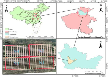
Accurate diagnosis of nitrogen status is essential for precision fertilization in winter wheat. Single-modal or single-temporal remote sensing often fails to capture the multidimensional crop responses to nitrogen stress. In this study, we propose a hybrid framework based on CNN-LSTM-XGBoost for interpretable classification of wheat nitrogen stress gradients using multimodal unmanned aerial vehicle (UAV) multispectral and thermal infrared (TIR) imagery. Field experiments were conducted at the Xinxiang base in Henan Province during the 2023–2024, following a randomized block design involving 10 cultivars, four nitrogen levels, and four water treatments. Multisource UAV images acquired at jointing, heading, and filling stages were used to construct a multimodal feature set consisting of manual features (spectral bands, vegetation indices (VIs), TIR, and their interaction terms) and seven temporal statistical features. A deep learning model (CNN-LSTM) was utilized to further extract deep spatiotemporal features, and its performance was systematically compared with traditional machine learning models. The results show that multimodal feature fusion significantly enhanced classification performance. The CNN-LSTM model achieved an accuracy of 89.38% with fused multimodal features, outperforming all traditional machine learning models. Incorporating multi-temporal features improved the F1macro of the XGBoost model to 0.9131, a 9.42 percentage-point increase over using the single heading stage alone. The hybrid model (CNN-LSTM-XGBoost) achieved the highest overall performance (Accuracy = 0.9208; F1macro = 0.9212; AUCmacro = 0.9879; Kappa = 0.8944). SHAP analysis identified TIR × NDRE as the most influential indicator, reflecting the coupled physiological response of reduced chlorophyll content and increased canopy temperature under nitrogen deficiency. The proposed multimodal, multi-temporal, and interpretable framework provides a robust technical foundation for UAV-assisted precision nitrogen management.

7 February 2026

Study area and experimental design.

Satellite precipitation products (SPPs) generally exhibit varying accuracy and error characteristics, which influence their applicability in hydrological modeling. Based on gauge-observed precipitation and streamflow data, as well as runoff simulations from the SWAT model, this study evaluates the data accuracy, hydrological utility, and error propagation characteristics of eight SPPs derived from the GSMaP, IMERG, and PERSIANN algorithms in the Yellow River Source Region (YRSR), an alpine mountainous watershed. Results show that for estimating precipitation amounts and detecting precipitation events, post-processed GSMaP_Gauge (GGauge) performs best, followed by IMERG Final run data. These two datasets present good substitutability for gauge-based observations and demonstrate considerable potential in streamflow modeling. Specifically, after parameter recalibration, the performance of GGauge is comparable to that of gauge-derived simulations. Most propagation ratios of systematic bias (γRB) exceed one, while the ratios of random error (γubRMSE) are below 1, indicating that, through hydrological simulation, systematic bias in precipitation data is more likely to be amplified, whereas random error is generally suppressed. Additionally, γubRMSE exhibits more pronounced autocorrelation than γRB, with hotspots in the central region and cold spots in the western part of the YRSR, which is highly related to the basin slope. The statistical features and spatial patterns of error propagation indices help to identify zones that are sensitive to precipitation errors in the study area and highlight the need for targeted strategies to address different types of data error in the modification of SPPs for hydrological application.

7 February 2026

Geographical location, elevation, and distribution of meteorological and hydrological sites in the Yellow River source region (YRSR).

Clouds critically influence Earth’s radiation balance and climate, making accurate cloud detection essential for improving climate models. This study develops the TSAR model to improve the cloud detection accuracy of the FY-4A CLM product by incorporating physical features. The input features include FY-4A brightness temperature (BT) data from channels 8–14, geometric parameters (satellite zenith angle (SAZ), satellite azimuth angle (SAA), solar zenith angle (SOZ), solar azimuth angle (SOA), and latitude), and four ERA5 meteorological factors (2 m air temperature (T2m), skin temperature (SKT), air temperature profiles (ATP), and relative humidity profiles (RH)). Using the CALIPSO cloud detection product as labels, the model outputs cloud/clear-sky classification results. Additionally, four machine learning (ML) algorithms—RF, LightGBM, XGBoost, and MLP—achieved overall accuracies of 91.5%, 92.2%, 92.5%, and 92.8%, respectively, considerably outperforming the FY-4A L2 CLM product (83.1%). The results demonstrate that incorporating physical factors significantly improves cloud detection performance regardless of the algorithm employed. Incorporating meteorological factors notably improved nighttime and water–cloud detection, narrowing day–night accuracy gaps. Shapley additive explanation (SHAP) analysis indicated feature contributions of 15.8%, 50.8%, and 33.3% from geometric, BT, and meteorological variables, respectively, with stronger meteorological effects at mid- to high-latitudes. These findings demonstrate that integrating meteorological factors significantly improves FY-4A cloud detection accuracy and consistency, highlighting the MLP-TSAR model’s effectiveness for reliable all-day operational applications.

7 February 2026

Individual (a) air temperature profile (ATP) and (b) relative humidity (RH) profile under cloudy and clear-sky conditions on 1 July 2020. The red and blue lines represent single-pixel profiles extracted from cloudy and clear-sky samples, respectively, illustrating the characteristic vertical structure differences between the two conditions.

Soil organic carbon (SOC) plays a critical role in the terrestrial carbon cycle, yet its spatial patterns and drivers in arid regions remain poorly understood. This study aims to clarify SOC distribution mechanisms in the Akesai region, where limited water–heat conditions and land use create high environmental heterogeneity. Four machine learning models were applied to predict SOC content and produce high-resolution spatial maps, and SHAP analysis was used to quantify the contributions of key environmental variables. The Gradient Boosting model had the best performance (R2 = 0.675; RMSE = 1.304 g kg−1), followed by XGBoost, LightGBM, and Random Forest. The results indicated that the main factors controlling SOC variation were NDVI, DEM, sand, clay, mean temperature, and ERVI. Furthermore, NDVI and clay parameters were positively associated with promoted SOC accumulation, while sand showed a negative effect. Spatially, higher SOC values were found in mountainous zones and vegetated valleys, while low SOC values were observed in flat, arid plains. These findings demonstrate that incorporating vegetation-type indicators substantially improves large-scale SOC estimation and enhances our understanding of SOC spatial dynamics and the driving mechanisms in arid environments. This provides a scientific basis for carbon-stock assessment and sustainable land management.

7 February 2026

Soil sampling sites and location of the Aksai region: (a) location of Gansu Province in China, (b) location of Aksai in Gansu Province, and (c) soil sampling sites and elevation map of the Aksai region.

News & Conferences

Issues

Open for Submission

Editor's Choice

Reprints of Collections

Advanced Multi-GNSS Positioning and Its Applications in Geoscience
Reprint

Advanced Multi-GNSS Positioning and Its Applications in Geoscience

Editors: Ahao Wang, Yize Zhang, Xuexi Liu, Xiangdong An, Junping Chen

Get Alerted

Add your email address to receive forthcoming issues of this journal.

XFacebookLinkedIn
Remote Sens. - ISSN 2072-4292