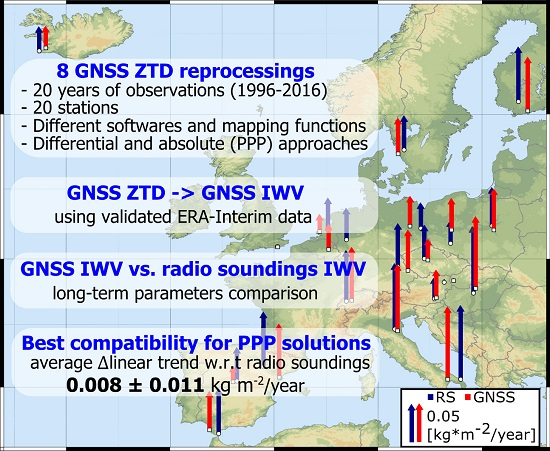
Assessment of the Impact of GNSS Processing Strategies on the Long-Term Parameters of 20 Years IWV Time Series


Abstract

1. Introduction
2. Methodology
2.1. Atmospheric Propagation Delay
2.2. ZTD from GNSS Processing
2.3. Meteorological Parameters
3. Results
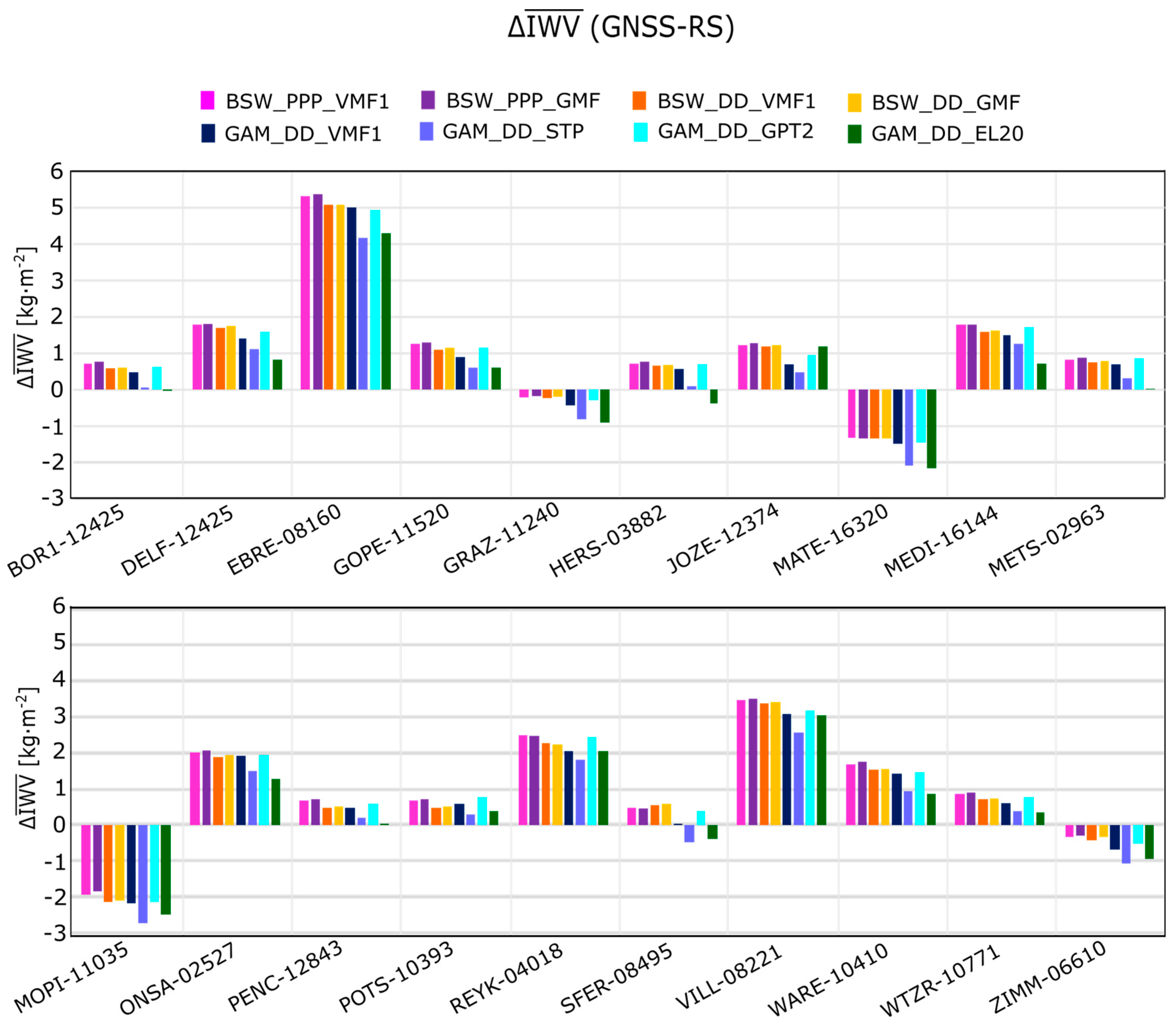
3.1. Mean IWV
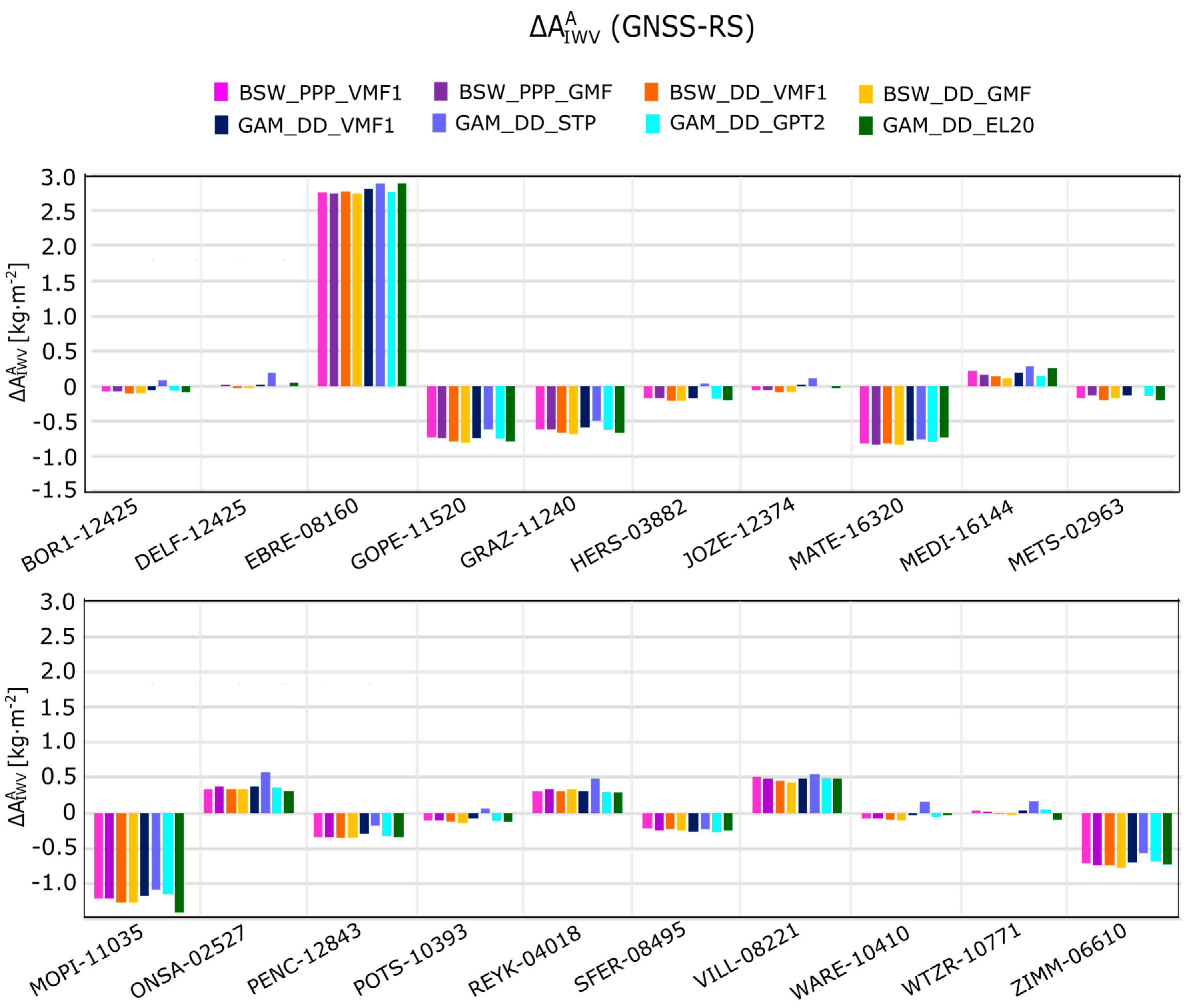
3.2. IWV Amplitudes
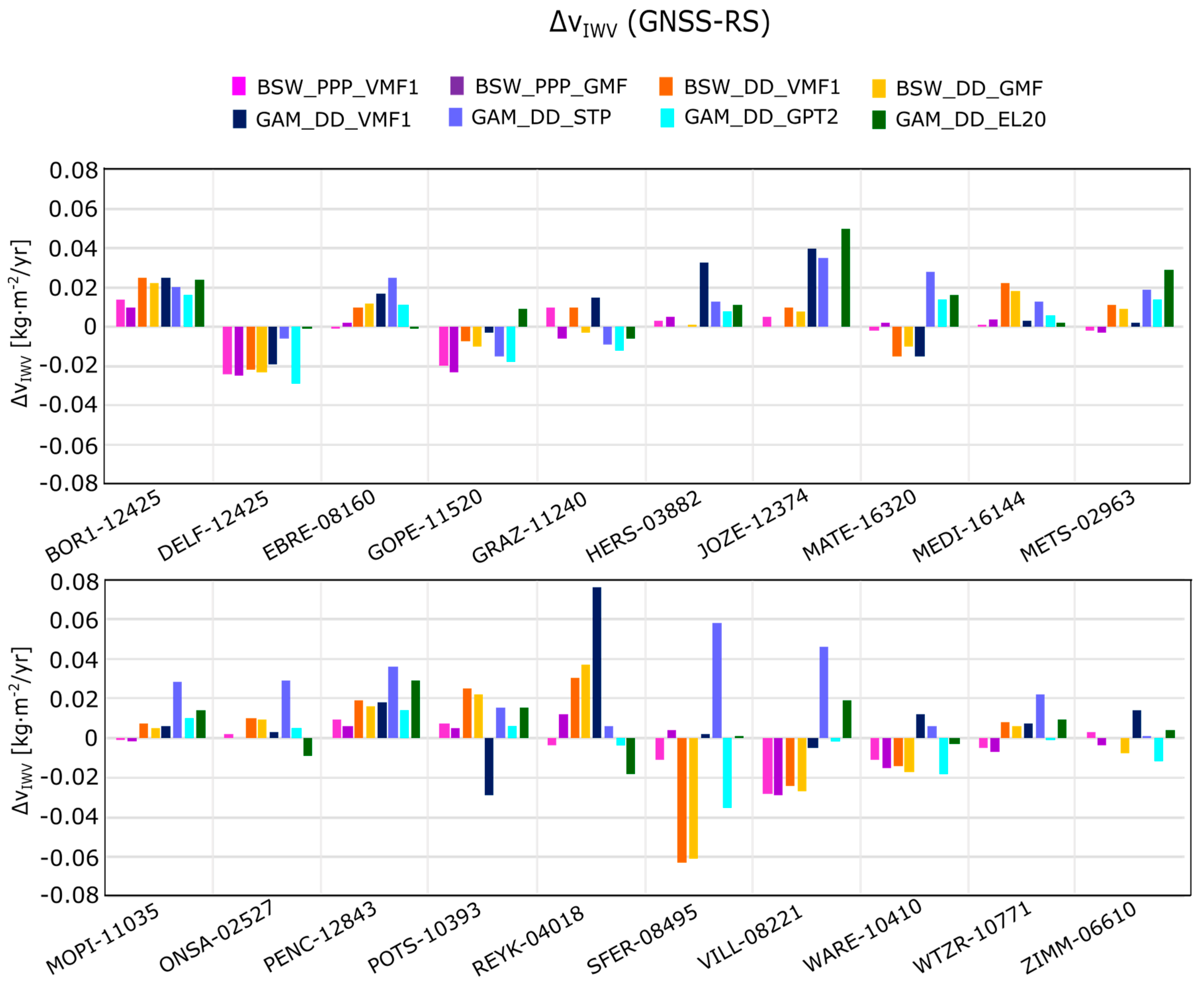
3.3. IWV Linear Trend
4. Discussion
5. Conclusions
- The highest consistency between the GNSS IWV linear trends and RS IWV linear trends was found for the PPP solutions. Both in terms of using VMF1 or GMF in PPP mode, estimated long term IWV changes were usually characterized by the highest accuracy.
- The highest differences between the GNSS PPP and RS were found only for these stations, which are located at higher altitudes. Therefore, some altitude-dependent error both for the GNSS PPP and RS methods should be considered in future works.
- DD solutions, widely regarded as the most accurate, were characterized by lower consistency w.r.t. RS than the PPP ones. The PPP solutions are realized individually, whereas the DD solutions are realized in regional network. This may indicate that, due to some network effects, the DD method may introduce to the troposphere solutions errors that affect the proper investigation of long term changes.
- GPT2 brings benefits to climate-related studies. This is probably due to the fact that this empirical model better represents long term tropospheric variations than numerical weather models like ECMWF, which are mostly focused on short-time forecasts.
Acknowledgments
Author Contributions
Conflicts of Interest
Abbreviations
| ATML | atmospheric loading model |
| DD | double differences |
| ECMWF | European Centre for Medium-Range Weather Forecasts |
| EPN | EUREF Permanent Network |
| EPN AC | EUREF Permanent Network Analysis Centre |
| GMF | global mapping function |
| GNSS | global navigation satellite systems |
| GPS | Global Positioning System |
| GPT | global pressure and temperature model |
| GPT2 | global pressure and temperature model 2 |
| IGS | International GNSS Service |
| IMF | isobaric mapping function |
| IWV | integrated water vapour |
| MUT | Military University of Technology |
| NMF | Niell mapping function |
| NWM | numerical weather model |
| PPP | precise point positioning |
| PWV | precipitable water vapour |
| RS | radio sounding |
| SHD | slant hydrostatic delay |
| STP | standard temperature pressure |
| SWD | slant wet delay |
| VLBI | very long baseline interferometry |
| VMF1 | Vienna mapping function 1 |
| ZHD | zenith hydrostatic delay |
| ZPD | zenith path delay |
| ZTD | zenith tropospheric delay |
| ZWD | zenith wet delay |
Appendix A

| GNSS Station | [kg m−2] | |||||||
|---|---|---|---|---|---|---|---|---|
| BSW_PPP_VMF | BSW_PPP_GMF | BSW_DD_VMF | BSW_DD_GMF | GAM_DD_VMF | GAM_DD_STP | GAM_DD_GPT2 | GAM_DD_EL20 | |
| BOR1 | 16.34 | 16.38 | 16.20 | 16.24 | 16.10 | 15.68 | 16.25 | 15.59 |
| DELF | 18.08 | 18.11 | 18.01 | 18.04 | 17.72 | 17.42 | 17.88 | 17.14 |
| EBRE | 22.01 | 22.05 | 21.76 | 21.77 | 21.69 | 20.86 | 21.64 | 20.98 |
| GOPE | 16.52 | 16.56 | 16.37 | 16.40 | 16.17 | 15.86 | 16.41 | 15.88 |
| GRAZ | 16.56 | 16.61 | 16.54 | 16.58 | 16.34 | 15.95 | 16.50 | 15.87 |
| HERS | 17.67 | 17.70 | 17.59 | 17.61 | 17.50 | 17.03 | 17.65 | 16.58 |
| JOZE | 16.48 | 16.53 | 16.45 | 16.49 | 15.94 | 15.73 | 16.20 | 16.43 |
| MATE | 17.46 | 17.45 | 17.43 | 17.44 | 17.31 | 16.71 | 17.34 | 16.62 |
| MEDI | 20.62 | 20.63 | 20.43 | 20.46 | 20.33 | 20.08 | 20.55 | 19.56 |
| METS | 12.86 | 12.91 | 12.78 | 12.82 | 12.72 | 12.34 | 12.88 | 12.07 |
| MOPI | 15.10 | 15.20 | 14.89 | 14.93 | 14.86 | 14.30 | 14.90 | 14.53 |
| ONSA | 15.19 | 15.26 | 15.06 | 15.12 | 15.08 | 14.65 | 15.11 | 14.45 |
| PENC | 17.33 | 17.35 | 17.15 | 17.17 | 17.12 | 16.84 | 17.23 | 16.66 |
| POTS | 16.18 | 16.22 | 15.99 | 16.02 | 16.10 | 15.79 | 16.28 | 15.91 |
| REYK | 13.97 | 13.94 | 13.74 | 13.71 | 13.52 | 13.28 | 13.89 | 13.49 |
| SFER | 20.01 | 19.96 | 20.07 | 20.08 | 19.52 | 19.02 | 19.89 | 19.12 |
| VILL | 17.41 | 17.46 | 17.31 | 17.35 | 17.02 | 16.52 | 17.13 | 17.00 |
| WARE | 17.14 | 17.20 | 16.99 | 17.01 | 16.90 | 16.39 | 16.92 | 16.35 |
| WTZR | 15.11 | 15.16 | 14.94 | 14.99 | 14.87 | 14.63 | 15.01 | 14.61 |
| ZIMM | 14.70 | 14.76 | 14.63 | 14.70 | 14.36 | 13.95 | 14.53 | 14.11 |
| RS Station | [kg m−2] | [kg m−2 /year] | [kg m−2] | [kg m−2] |
|---|---|---|---|---|
| 02527 | 13.17 ± 0.09 | 0.046 ± 0.009 | 6.96 ± 0.07 | 1.51 ± 0.07 |
| 02963 | 12.03 ± 0.09 | 0.079 ± 0.007 | 7.83 ± 0.06 | 2.04 ± 0.06 |
| 03882 | 16.94 ± 0.10 | 0.001 ± 0.009 | 6.77 ± 0.07 | 1.00 ± 0.07 |
| 04018 | 11.46 ± 0.08 | 0.029 ± 0.007 | 4.67 ± 0.06 | 1.45 ± 0.06 |
| 06260 | 16.30 ± 0.07 | 0.043 ± 0.008 | 7.02 ± 0.06 | 1.09 ± 0.06 |
| 06610 | 15.04 ± 0.08 | 0.073 ± 0.007 | 7.88 ± 0.06 | 0.96 ± 0.06 |
| 08160 | 16.68 ± 0.10 | 0.078 ± 0.009 | 7.08 ± 0.07 | 0.75 ± 0.07 |
| 08221 | 13.95 ± 0.09 | 0.044 ± 0.008 | 5.00 ± 0.06 | 0.22 ± 0.06 |
| 08495 | 19.51 ± 0.11 | 0.063 ± 0.011 | 5.52 ± 0.08 | 0.99 ± 0.08 |
| 10393 | 15.51 ± 0.07 | 0.032 ± 0.006 | 8.11 ± 0.05 | 1.37 ± 0.05 |
| 10410 | 15.46 ± 0.09 | 0.042 ± 0.008 | 7.22 ± 0.07 | 1.07 ± 0.07 |
| 10771 | 14.24 ± 0.09 | 0.060 ± 0.007 | 7.52 ± 0.06 | 1.19 ± 0.06 |
| 11035 | 17.04 ± 0.09 | 0.005 ± 0.008 | 9.27 ± 0.06 | 1.41 ± 0.06 |
| 11240 | 16.77 ± 0.13 | 0.025 ± 0.011 | 9.67 ± 0.09 | 1.28 ± 0.09 |
| 11520 | 15.26 ± 0.09 | 0.044 ± 0.008 | 8.34 ± 0.06 | 1.35 ± 0.06 |
| 12374 | 15.25 ± 0.10 | 0.052 ± 0.008 | 8.82 ± 0.07 | 1.78 ± 0.07 |
| 12425 | 15.62 ± 0.10 | 0.028 ± 0.008 | 8.63 ± 0.07 | 1.59 ± 0.07 |
| 12843 | 16.65 ± 0.10 | 0.097 ± 0.009 | 9.38 ± 0.07 | 1.36 ± 0.07 |
| 16144 | 18.83 ± 0.11 | 0.096 ± 0.011 | 9.63 ± 0.08 | 0.76 ± 0.08 |
| 16320 | 18.79 ± 0.08 | 0.109 ± 0.007 | 7.75 ± 0.06 | 0.27 ± 0.06 |
| GNSS Station | RS Station | [kg m−2] (GNSS-RS) | |||||||
|---|---|---|---|---|---|---|---|---|---|
| BSW_PPP_VMF | BSW_PPP_GMF | BSW_DD_VMF | BSW_DD_GMF | GAM_DD_VMF | GAM_DD_STP | GAM_DD_GPT2 | GAM_DD_EL20 | ||
| BOR1 | 12425 | 0.72 | 0.76 | 0.58 | 0.62 | 0.48 | 0.06 | 0.63 | −0.03 |
| DELF | 06260 | 1.78 | 1.81 | 1.71 | 1.74 | 1.42 | 1.12 | 1.58 | 0.84 |
| EBRE | 08160 | 5.33 | 5.37 | 5.08 | 5.09 | 5.01 | 4.18 | 4.96 | 4.30 |
| GOPE | 11520 | 1.26 | 1.30 | 1.11 | 1.14 | 0.91 | 0.60 | 1.15 | 0.62 |
| GRAZ | 11240 | −0.21 | −0.16 | −0.23 | −0.19 | −0.43 | −0.82 | −0.27 | −0.90 |
| HERS | 03882 | 0.73 | 0.76 | 0.65 | 0.67 | 0.56 | 0.09 | 0.71 | −0.36 |
| JOZE | 12374 | 1.23 | 1.28 | 1.20 | 1.24 | 0.69 | 0.48 | 0.95 | 1.18 |
| MATE | 16320 | −1.33 | −1.34 | −1.36 | −1.35 | −1.48 | −2.08 | −1.45 | −2.17 |
| MEDI | 16144 | 1.79 | 1.80 | 1.60 | 1.63 | 1.50 | 1.25 | 1.72 | 0.73 |
| METS | 02963 | 0.83 | 0.88 | 0.75 | 0.79 | 0.69 | 0.31 | 0.85 | 0.04 |
| MOPI | 11035 | −1.94 | −1.84 | −2.15 | −2.11 | −2.18 | −2.74 | −2.14 | −2.51 |
| ONSA | 02527 | 2.02 | 2.09 | 1.89 | 1.95 | 1.91 | 1.48 | 1.94 | 1.28 |
| PENC | 12843 | 0.68 | 0.70 | 0.50 | 0.52 | 0.47 | 0.19 | 0.58 | 0.01 |
| POTS | 10393 | 0.67 | 0.71 | 0.48 | 0.51 | 0.59 | 0.28 | 0.77 | 0.40 |
| REYK | 04018 | 2.51 | 2.48 | 2.28 | 2.25 | 2.06 | 1.82 | 2.43 | 2.03 |
| SFER | 08495 | 0.50 | 0.45 | 0.56 | 0.57 | 0.01 | −0.49 | 0.38 | −0.39 |
| VILL | 08221 | 3.46 | 3.51 | 3.36 | 3.40 | 3.07 | 2.57 | 3.18 | 3.05 |
| WARE | 10410 | 1.68 | 1.74 | 1.53 | 1.55 | 1.44 | 0.93 | 1.46 | 0.89 |
| WTZR | 10771 | 0.87 | 0.92 | 0.70 | 0.75 | 0.63 | 0.39 | 0.77 | 0.37 |
| ZIMM | 06610 | −0.34 | −0.28 | −0.41 | −0.34 | −0.68 | −1.09 | −0.51 | −0.93 |
| Absolute mean | 1.49 | 1.51 | 1.41 | 1.42 | 1.31 | 1.15 | 1.42 | 1.15 | |
| GNSS Station | [kg m−2] | |||||||
|---|---|---|---|---|---|---|---|---|
| BSW_PPP_VMF | BSW_PPP_GMF | BSW_DD_VMF | BSW_DD_GMF | GAM_DD_VMF | GAM_DD_STP | GAM_DD_GPT2 | GAM_DD_EL20 | |
| BOR1 | 8.55 | 8.56 | 8.53 | 8.53 | 8.58 | 8.72 | 8.57 | 8.54 |
| DELF | 7.02 | 7.03 | 7.00 | 7.00 | 7.03 | 7.21 | 7.02 | 7.08 |
| EBRE | 9.85 | 9.82 | 9.86 | 9.83 | 9.89 | 9.96 | 9.84 | 9.96 |
| GOPE | 7.61 | 7.60 | 7.55 | 7.54 | 7.60 | 7.73 | 7.60 | 7.55 |
| GRAZ | 9.06 | 9.05 | 9.01 | 8.99 | 9.08 | 9.18 | 9.06 | 9.00 |
| HERS | 6.59 | 6.59 | 6.54 | 6.53 | 6.59 | 6.79 | 6.59 | 6.55 |
| JOZE | 8.75 | 8.75 | 8.72 | 8.72 | 8.82 | 8.93 | 8.81 | 8.79 |
| MATE | 6.93 | 6.92 | 6.93 | 6.91 | 6.98 | 7.00 | 6.96 | 7.02 |
| MEDI | 9.84 | 9.78 | 9.77 | 9.74 | 9.81 | 9.91 | 9.76 | 9.87 |
| METS | 7.66 | 7.70 | 7.64 | 7.66 | 7.70 | 7.83 | 7.70 | 7.64 |
| MOPI | 8.06 | 8.06 | 8.00 | 7.99 | 8.09 | 8.18 | 8.12 | 7.85 |
| ONSA | 7.32 | 7.35 | 7.31 | 7.32 | 7.35 | 7.54 | 7.33 | 7.29 |
| PENC | 9.04 | 9.04 | 9.03 | 9.02 | 9.08 | 9.19 | 9.06 | 9.04 |
| POTS | 8.00 | 8.00 | 7.98 | 7.97 | 8.03 | 8.18 | 8.00 | 7.98 |
| REYK | 4.97 | 5.00 | 4.98 | 5.00 | 4.98 | 5.15 | 4.96 | 4.95 |
| SFER | 5.30 | 5.28 | 5.29 | 5.28 | 5.26 | 5.29 | 5.26 | 5.28 |
| VILL | 5.49 | 5.45 | 5.43 | 5.40 | 5.45 | 5.52 | 5.45 | 5.46 |
| WARE | 7.15 | 7.15 | 7.13 | 7.12 | 7.19 | 7.38 | 7.18 | 7.19 |
| WTZR | 7.51 | 7.49 | 7.46 | 7.44 | 7.51 | 7.65 | 7.52 | 7.38 |
| ZIMM | 7.17 | 7.14 | 7.14 | 7.11 | 7.18 | 7.31 | 7.20 | 7.15 |
| GNSS Station | RS Station | [kg m−2] (GNSS-RS) | |||||||
|---|---|---|---|---|---|---|---|---|---|
| BSW_PPP_VMF | BSW_PPP_GMF | BSW_DD_VMF | BSW_DD_GMF | GAM_DD_VMF | GAM_DD_STP | GAM_DD_GPT2 | GAM_DD_EL20 | ||
| BOR1 | 12425 | −0.08 | −0.07 | −0.10 | −0.10 | −0.05 | 0.09 | −0.06 | −0.09 |
| DELF | 06260 | 0.00 | 0.01 | −0.02 | −0.02 | 0.01 | 0.19 | 0.00 | 0.06 |
| EBRE | 08160 | 2.77 | 2.74 | 2.78 | 2.75 | 2.81 | 2.88 | 2.76 | 2.88 |
| GOPE | 11520 | −0.73 | −0.74 | −0.79 | −0.80 | −0.74 | −0.61 | −0.74 | −0.79 |
| GRAZ | 11240 | −0.61 | −0.62 | −0.66 | −0.68 | −0.59 | −0.49 | −0.61 | −0.67 |
| HERS | 03882 | −0.16 | −0.16 | −0.21 | −0.22 | −0.16 | 0.04 | −0.16 | −0.20 |
| JOZE | 12374 | −0.06 | −0.06 | −0.09 | −0.09 | 0.01 | 0.12 | 0.00 | −0.02 |
| MATE | 16320 | −0.82 | −0.83 | −0.82 | −0.84 | −0.77 | −0.75 | −0.79 | −0.73 |
| MEDI | 16144 | 0.22 | 0.16 | 0.15 | 0.12 | 0.19 | 0.29 | 0.14 | 0.25 |
| METS | 02963 | −0.17 | −0.13 | −0.19 | −0.17 | −0.13 | 0.00 | −0.13 | −0.19 |
| MOPI | 11035 | −1.21 | −1.21 | −1.27 | −1.28 | −1.18 | −1.09 | −1.15 | −1.42 |
| ONSA | 02527 | 0.35 | 0.38 | 0.34 | 0.35 | 0.38 | 0.57 | 0.36 | 0.32 |
| PENC | 12843 | −0.34 | −0.34 | −0.35 | −0.36 | −0.30 | −0.19 | −0.32 | −0.34 |
| POTS | 10393 | −0.11 | −0.11 | −0.13 | −0.14 | −0.08 | 0.07 | −0.11 | −0.13 |
| REYK | 04018 | 0.31 | 0.34 | 0.32 | 0.34 | 0.32 | 0.49 | 0.30 | 0.29 |
| SFER | 08495 | −0.22 | −0.24 | −0.23 | −0.24 | −0.26 | −0.23 | −0.26 | −0.24 |
| VILL | 08221 | 0.52 | 0.48 | 0.46 | 0.43 | 0.48 | 0.55 | 0.48 | 0.49 |
| WARE | 10410 | −0.07 | −0.07 | −0.09 | −0.10 | −0.03 | 0.16 | −0.04 | −0.03 |
| WTZR | 10771 | 0.04 | 0.02 | −0.01 | −0.03 | 0.04 | 0.18 | 0.05 | −0.09 |
| ZIMM | 06610 | −0.71 | −0.74 | −0.74 | −0.77 | −0.70 | −0.57 | −0.68 | −0.73 |
| Absolute mean | 0.48 | 0.47 | 0.49 | 0.49 | 0.46 | 0.48 | 0.46 | 0.50 | |
| GNSS Station | [kg m−2] | |||||||
|---|---|---|---|---|---|---|---|---|
| BSW_PPP_VMF | BSW_PPP_GMF | BSW_DD_VMF | BSW_DD_GMF | GAM_DD_VMF | GAM_DD_STP | GAM_DD_GPT2 | GAM_DD_EL20 | |
| BOR1 | 1.61 | 1.63 | 1.62 | 1.60 | 1.60 | 1.57 | 1.63 | 1.58 |
| DELF | 1.01 | 1.05 | 1.03 | 0.99 | 1.03 | 0.97 | 1.03 | 0.98 |
| EBRE | 1.29 | 1.34 | 1.35 | 1.30 | 1.32 | 1.26 | 1.33 | 1.27 |
| GOPE | 1.29 | 1.31 | 1.28 | 1.25 | 1.25 | 1.23 | 1.28 | 1.24 |
| GRAZ | 1.30 | 1.32 | 1.32 | 1.29 | 1.29 | 1.25 | 1.29 | 1.29 |
| HERS | 0.91 | 0.95 | 0.96 | 0.92 | 0.93 | 0.86 | 0.94 | 0.88 |
| JOZE | 1.83 | 1.85 | 1.85 | 1.84 | 1.78 | 1.76 | 1.80 | 1.87 |
| MATE | 0.23 | 0.24 | 0.23 | 0.21 | 0.19 | 0.21 | 0.24 | 0.16 |
| MEDI | 0.81 | 0.85 | 0.81 | 0.78 | 0.80 | 0.74 | 0.80 | 0.79 |
| METS | 1.96 | 1.98 | 1.97 | 1.95 | 1.91 | 1.90 | 1.97 | 1.93 |
| MOPI | 1.38 | 1.38 | 1.38 | 1.36 | 1.33 | 1.30 | 1.37 | 1.33 |
| ONSA | 1.54 | 1.56 | 1.54 | 1.52 | 1.50 | 1.49 | 1.56 | 1.46 |
| PENC | 1.36 | 1.38 | 1.36 | 1.34 | 1.35 | 1.31 | 1.36 | 1.33 |
| POTS | 1.40 | 1.41 | 1.38 | 1.36 | 1.38 | 1.33 | 1.39 | 1.34 |
| REYK | 1.50 | 1.53 | 1.52 | 1.50 | 1.50 | 1.45 | 1.53 | 1.42 |
| SFER | 1.29 | 1.25 | 1.14 | 1.19 | 1.13 | 1.20 | 1.14 | 1.19 |
| VILL | 0.33 | 0.32 | 0.31 | 0.33 | 0.33 | 0.38 | 0.35 | 0.35 |
| WARE | 1.05 | 1.08 | 1.06 | 1.03 | 1.04 | 0.98 | 1.05 | 0.99 |
| WTZR | 1.27 | 1.29 | 1.27 | 1.25 | 1.25 | 1.21 | 1.28 | 1.25 |
| ZIMM | 0.88 | 0.92 | 0.89 | 0.85 | 0.88 | 0.84 | 0.89 | 0.83 |
| GNSS Station | RS Station | [kg m−2] (GNSS-RS) | |||||||
|---|---|---|---|---|---|---|---|---|---|
| BSW_PPP_VMF | BSW_PPP_GMF | BSW_DD_VMF | BSW_DD_GMF | GAM_DD_VMF | GAM_DD_STP | GAM_DD_GPT2 | GAM_DD_EL20 | ||
| BOR1 | 12425 | 0.02 | 0.04 | 0.03 | 0.01 | 0.01 | −0.02 | 0.04 | −0.01 |
| DELF | 06260 | −0.08 | −0.04 | −0.06 | −0.10 | −0.06 | −0.12 | −0.06 | −0.11 |
| EBRE | 08160 | 0.54 | 0.59 | 0.60 | 0.55 | 0.57 | 0.51 | 0.58 | 0.52 |
| GOPE | 11520 | −0.06 | −0.04 | −0.07 | −0.10 | −0.10 | −0.12 | −0.07 | −0.11 |
| GRAZ | 11240 | 0.02 | 0.04 | 0.04 | 0.01 | 0.01 | −0.03 | 0.01 | 0.01 |
| HERS | 03882 | −0.11 | −0.07 | −0.06 | −0.10 | −0.09 | −0.16 | −0.08 | −0.14 |
| JOZE | 12374 | 0.05 | 0.07 | 0.07 | 0.06 | 0.00 | −0.02 | 0.02 | 0.09 |
| MATE | 16320 | −0.04 | −0.03 | −0.04 | −0.06 | −0.08 | −0.06 | −0.03 | −0.11 |
| MEDI | 16144 | 0.04 | 0.08 | 0.04 | 0.01 | 0.03 | −0.03 | 0.03 | 0.02 |
| METS | 02963 | −0.09 | −0.07 | −0.08 | −0.10 | −0.14 | −0.15 | −0.08 | −0.12 |
| MOPI | 11035 | −0.04 | −0.04 | −0.04 | −0.06 | −0.09 | −0.12 | −0.05 | −0.09 |
| ONSA | 02527 | 0.02 | 0.04 | 0.02 | 0.00 | −0.02 | −0.03 | 0.04 | −0.06 |
| PENC | 12843 | 0.00 | 0.02 | 0.00 | −0.02 | −0.01 | −0.05 | 0.00 | −0.03 |
| POTS | 10393 | 0.03 | 0.04 | 0.01 | −0.01 | 0.01 | −0.04 | 0.02 | −0.03 |
| REYK | 04018 | 0.07 | 0.10 | 0.09 | 0.07 | 0.07 | 0.02 | 0.10 | −0.01 |
| SFER | 08495 | 0.30 | 0.26 | 0.15 | 0.20 | 0.14 | 0.21 | 0.15 | 0.20 |
| VILL | 08221 | 0.07 | 0.06 | 0.05 | 0.07 | 0.07 | 0.12 | 0.09 | 0.09 |
| WARE | 10410 | −0.02 | 0.01 | −0.01 | −0.04 | −0.03 | −0.09 | −0.02 | −0.08 |
| WTZR | 10771 | 0.10 | 0.12 | 0.10 | 0.08 | 0.08 | 0.04 | 0.11 | 0.08 |
| ZIMM | 06610 | −0.08 | −0.04 | −0.07 | −0.11 | −0.08 | −0.12 | −0.07 | −0.13 |
| Absolute mean | 0.09 | 0.09 | 0.08 | 0.09 | 0.08 | 0.10 | 0.08 | 0.10 | |
| GNSS Station | [kg m−2/year] | |||||||
|---|---|---|---|---|---|---|---|---|
| BSW_PPP_VMF | BSW_PPP_GMF | BSW_DD_VMF | BSW_DD_GMF | GAM_DD_VMF | GAM_DD_STP | GAM_DD_GPT2 | GAM_DD_EL20 | |
| BOR1 | 0.042 | 0.038 | 0.053 | 0.050 | 0.053 | 0.048 | 0.044 | 0.052 |
| DELF | 0.019 | 0.018 | 0.021 | 0.020 | 0.024 | 0.037 | 0.014 | 0.042 |
| EBRE | 0.077 | 0.080 | 0.088 | 0.090 | 0.095 | 0.103 | 0.089 | 0.077 |
| GOPE | 0.024 | 0.021 | 0.037 | 0.034 | 0.041 | 0.029 | 0.026 | 0.053 |
| GRAZ | 0.035 | 0.019 | 0.035 | 0.022 | 0.040 | 0.016 | 0.013 | 0.019 |
| HERS | 0.004 | 0.006 | 0.001 | 0.002 | 0.034 | 0.014 | 0.009 | 0.012 |
| JOZE | 0.057 | 0.052 | 0.062 | 0.060 | 0.092 | 0.087 | 0.052 | 0.102 |
| MATE | 0.107 | 0.111 | 0.094 | 0.099 | 0.094 | 0.137 | 0.123 | 0.125 |
| MEDI | 0.097 | 0.100 | 0.118 | 0.114 | 0.099 | 0.109 | 0.102 | 0.098 |
| METS | 0.077 | 0.076 | 0.090 | 0.088 | 0.081 | 0.098 | 0.093 | 0.108 |
| MOPI | 0.004 | 0.003 | 0.012 | 0.010 | 0.011 | 0.033 | 0.015 | 0.019 |
| ONSA | 0.048 | 0.046 | 0.056 | 0.055 | 0.049 | 0.075 | 0.051 | 0.037 |
| PENC | 0.106 | 0.103 | 0.116 | 0.113 | 0.115 | 0.133 | 0.111 | 0.126 |
| POTS | 0.039 | 0.037 | 0.057 | 0.054 | 0.003 | 0.047 | 0.038 | 0.047 |
| REYK | 0.025 | 0.041 | 0.059 | 0.066 | 0.105 | 0.035 | 0.025 | 0.011 |
| SFER | 0.052 | 0.067 | 0.000 | 0.002 | 0.065 | 0.121 | 0.028 | 0.064 |
| VILL | 0.016 | 0.015 | 0.020 | 0.017 | 0.039 | 0.090 | 0.042 | 0.063 |
| WARE | 0.031 | 0.027 | 0.028 | 0.025 | 0.054 | 0.048 | 0.024 | 0.039 |
| WTZR | 0.055 | 0.053 | 0.068 | 0.066 | 0.067 | 0.082 | 0.059 | 0.069 |
| ZIMM | 0.076 | 0.069 | 0.073 | 0.065 | 0.087 | 0.074 | 0.061 | 0.077 |
| GNSS Station | RS Station | [kg m−2/year] (GNSS-RS) | |||||||
|---|---|---|---|---|---|---|---|---|---|
| BSW_PPP_VMF | BSW_PPP_GMF | BSW_DD_VMF | BSW_DD_GMF | GAM_DD_VMF | GAM_DD_STP | GAM_DD_GPT2 | GAM_DD_EL20 | ||
| BOR1 | 12425 | 0.014 | 0.010 | 0.025 | 0.022 | 0.025 | 0.020 | 0.016 | 0.024 |
| DELF | 06260 | −0.024 | −0.025 | −0.022 | −0.023 | −0.019 | −0.006 | −0.029 | −0.001 |
| EBRE | 08160 | −0.001 | 0.002 | 0.010 | 0.012 | 0.017 | 0.025 | 0.011 | −0.001 |
| GOPE | 11520 | −0.020 | −0.023 | −0.007 | −0.010 | −0.003 | −0.015 | −0.018 | 0.009 |
| GRAZ | 11240 | 0.010 | −0.006 | 0.010 | −0.003 | 0.015 | −0.009 | −0.012 | −0.006 |
| HERS | 03882 | 0.003 | 0.005 | 0.000 | 0.001 | 0.033 | 0.013 | 0.008 | 0.011 |
| JOZE | 12374 | 0.005 | 0.000 | 0.010 | 0.008 | 0.040 | 0.035 | 0.000 | 0.050 |
| MATE | 16320 | −0.002 | 0.002 | −0.015 | −0.010 | −0.015 | 0.028 | 0.014 | 0.016 |
| MEDI | 16144 | 0.001 | 0.004 | 0.022 | 0.018 | 0.003 | 0.013 | 0.006 | 0.002 |
| METS | 02963 | −0.002 | −0.003 | 0.011 | 0.009 | 0.002 | 0.019 | 0.014 | 0.029 |
| MOPI | 11035 | −0.001 | −0.002 | 0.007 | 0.005 | 0.006 | 0.028 | 0.010 | 0.014 |
| ONSA | 02527 | 0.002 | 0.000 | 0.010 | 0.009 | 0.003 | 0.029 | 0.005 | −0.009 |
| PENC | 12843 | 0.009 | 0.006 | 0.019 | 0.016 | 0.018 | 0.036 | 0.014 | 0.029 |
| POTS | 10393 | 0.007 | 0.005 | 0.025 | 0.022 | −0.029 | 0.015 | 0.006 | 0.015 |
| REYK | 04018 | −0.004 | 0.012 | 0.030 | 0.037 | 0.076 | 0.006 | −0.004 | −0.018 |
| SFER | 08495 | −0.011 | 0.004 | −0.063 | −0.061 | 0.002 | 0.058 | −0.035 | 0.001 |
| VILL | 08221 | −0.028 | −0.029 | −0.024 | −0.027 | −0.005 | 0.046 | −0.002 | 0.019 |
| WARE | 10410 | −0.011 | −0.015 | −0.014 | −0.017 | 0.012 | 0.006 | −0.018 | −0.003 |
| WTZR | 10771 | −0.005 | −0.007 | 0.008 | 0.006 | 0.007 | 0.022 | −0.001 | 0.009 |
| ZIMM | 06610 | 0.003 | −0.004 | 0.000 | −0.008 | 0.014 | 0.001 | −0.012 | 0.004 |
| Absolute mean | 0.008 | 0.008 | 0.017 | 0.016 | 0.017 | 0.022 | 0.012 | 0.014 | |
| SD | 0.011 | 0.011 | 0.022 | 0.022 | 0.023 | 0.018 | 0.015 | 0.016 | |
References
- Baldysz, Z.; Nykiel, G.; Figurski, M.; Szafranek, K.; Kroszczynski, K. Investigation of the 16-year and 18-year ZTD Time Series Derived from GPS DATA Processing. Acta Geophys. 2015, 63, 1103–1125. [Google Scholar] [CrossRef]
- Baldysz, Z.; Nykiel, G.; Araszkiewicz, A.; Figurski, M.; Szafranek, K. Comparison of GPS tropospheric delays derived from two consecutive EPN reprocessing campaigns from the point of view of climate monitoring. Atmos. Meas. Tech. 2016, 9, 4861–4877. [Google Scholar] [CrossRef]
- Hagemann, S.; Bengtsson, L. On the determination of atmospheric water vapor from GPS measurements. J. Geophys. Res. 2003, 108, 4678. [Google Scholar] [CrossRef]
- Morland, J.; Collaud Coen, M.; Hocke, K.; Jeannet, P.; Matzler, C. Tropospheric water vapour above Switzerland over the last 12 years. Atmos. Chem. Phys. 2009, 9, 5975–5988. [Google Scholar] [CrossRef]
- Guerova, G.; Jones, J.; Dousa, J.; Dick, G.; de Haan, S.; Pottiaux, E.; Bock, O.; Pacione, R.; Elgered, G.; Vedel, H.; et al. Review of the state of the art and future prospects of the ground-based gnss meteorology in Europe. Atmos. Meas. Tech. 2016, 9, 5385–5406. [Google Scholar] [CrossRef]
- Yong, W.; Binyun, Y.; Debao, W.; Yanping, L. Zenith Tropospheric Delay from GPS monitoring climate change of Chinese Mainland, Education Technology and Training. In Proceedings of the 2008 International Workshop on Geoscience and Remote Sensing, ETT and GRS 2008, Shanghai, China, 21–22 December 2008. [Google Scholar] [CrossRef]
- Bevis, M.; Businger, S.; Herring, T.; Rocken, C.; Anthes, R.; Ware, R. GPS meteorology: Remote sensing of atmospheric water vapor using the global positioning system. J. Geophys. Res. 1992, 97, 15787–15801. [Google Scholar] [CrossRef]
- Wang, J.; Zhang, L. Climate applications of a global, 2-hourly atmospheric precipitable water dataset derived from IGS tropospheric products. J. Geodesy 2009, 83, 209–217. [Google Scholar] [CrossRef]
- Nilsson, T.; Elgered, G. Long-term trends in the atmospheric water vapor content estimated from ground-based GPS data. J. Geophys. Res. 2008, 113, D19101. [Google Scholar] [CrossRef]
- Ning, T.; Elgered, G.; Willen, U.; Johansson, J.M. Evaluation of the atmospheric water vapour content in a regional climate model using ground-based GPS measurements. J. Geophys. Res. 2013, 118, 329–339. [Google Scholar] [CrossRef]
- Guerova, G.; Bettems, J.-M.; Brockmann, E.; Matzler, C. Assimilation of the GPS-derived integrated water vapouur (IWV) in the MeteoSwiss numerical weather prediction model. Phys. Chem. Earth Parts 2004, 29, 177–186. [Google Scholar] [CrossRef]
- Nykiel, G.; Wolak, P.; Figurski, M. Atmospheric opacity estimation based on IWV derived from GNSS observations for VLBI applications. GPS Solut. 2018, 22, 9. [Google Scholar] [CrossRef]
- Ning, T.; Wang, J.; Elgered, G.; Dick, G.; Wickert, J.; Bradke, M.; Sommer, M.; Sommer, M.; Querel, R.; Smale, D. The uncertainty of the atmospheric integrated water vapour estimated from GNSS observations. Atmos. Meas. Tech. 2016, 9, 79–92. [Google Scholar] [CrossRef]
- Tregoning, P.; Herring, T.A. Impact of a priori zenith hydrostatic delay errors on GPS estimates of station heights and zenith total delays. Geophys. Res. Lett. 2006, 33. [Google Scholar] [CrossRef]
- Boehm, J.; Heinkelmann, R. Schuh H Short note: A global model of pressure and temperature for geodetic applications. J. Geodesy 2007. [Google Scholar] [CrossRef]
- Vey, S.; Dietrich, R.; Fritsche, M.; Rülke, A.; Rothacher, M.; Steigenberger, P. Influence of mapping functions parameters on global GPS network analyses: Comparison between NMF and IMF. Geophys. Res. Lett. 2006, 33, L01814. [Google Scholar] [CrossRef]
- Niell, A.E. Global mapping functions for the atmospheric delay at radio wavelengths. J. Geophys. Res. 1996, 101, 3227–3246. [Google Scholar] [CrossRef]
- Niell, A.E. Improved atmospheric mapping functions for VLBI and GPS. Earth Planet Space 2000, 52, 699–702. [Google Scholar] [CrossRef]
- Steigenberger, P.; Boehm, J.; Tesmer, V. Comparison of GMF/GPT with VMF1/ECMWF and Implications for Atmospheric Loading. J. Geodesy 2009, 83, 943. [Google Scholar] [CrossRef]
- Boehm, J.; Niell, A.; Tregoning, P.; Schuh, H. Global mapping function (GMF): A new empirical mapping function based on numerical weather model data. Geophys. Res. Lett. 2006, 33, L07304. [Google Scholar] [CrossRef]
- Boehm, J.; Werl, B.; Schuh, H. Troposphere mapping functions for GPS and very long baseline interferometry from European Centre for Medium-Range Weather Forecasts operational analysis data. J. Geophys. Res. 2006, 111, B02406. [Google Scholar] [CrossRef]
- Thomas, I.D.; King, M.A.; Clarke, P.J.; Penna, N.T. Precipitable water vapor estimates from homogeneously reprocessed GPS data: An intertechnique comparison in Antarctica. J. Geophys. Res. 2011, 116. [Google Scholar] [CrossRef]
- Schmid, R.; Steigenberger, P.; Gendt, G.; Ge, M.; Rothacher, M. Generation of a consistent absolute phase center correction model for GPS receiver and satellite antennas. J. Geodesy 2007, 81, 781–798. [Google Scholar] [CrossRef]
- Elósegui, P.; Davis, J.L.; Jaldehag, R.T.K.; Johansson, J.M.; Niell, A.E.; Shapiro, I.I. Geodesy using the global positioning system: The effects of signal scattering on estimates of site position. J. Geophys. Res. 1995, 100, 9921–9934. [Google Scholar] [CrossRef]
- Vey, S.; Dietrich, R.; Fritsche, M.; Rülke, A.; Steigenberger, P.; Rothacher, M. On the homogeneity and interpretation of precipitable water time series derived from global GPS observations. J. Geophys. Res. 2009, 114, D10101. [Google Scholar] [CrossRef]
- Dousa, J.; Vaclavovic, P.; Elias, M. Tropospheric products of the second GOP European GNSS reproessing (1996-2014). Atmos. Meas. Tech. 2017, 10, 3589–3607. [Google Scholar] [CrossRef]
- Bruyninx, C.; Habrich, H.; Söhne, W.; Kenyeres, A.; Stangl, G.; Völksen, C. Enhancement of the EUREF Permanent Network Services and Products. Geodesy Planet Earth 2012, 136, 27–35. [Google Scholar] [CrossRef]
- Ning, T.; Elgered, G. Trends in Atmopsheric Water Vapour Content From Ground-Based GPS: The Impact of the Elevation Cutoff Angle. IEEE J. Sel. Top. Appl. Earth Obs. Remote Sens. 2012, 5. [Google Scholar] [CrossRef]
- Dee, D.P.; Uppala, S.M.; Simmons, A.J.; Berrisford, P.; Poli, P.; Kobayashi, S.; Andrae, U.; Balmaseda, M.A.; Balsamo, G.; Bauer, P.; et al. The ERA-Interim reanalysis: Configuration and performance of the data assimilation system. Q. J. R. Meteorol. Soc. 2011, 137, 553–597. [Google Scholar] [CrossRef]
- Dach, R.; Lutz, S.; Walser, P.; Fridez, P. Bernese GNSS Software Version 5.2; User Manual; Astronomical Institute, University of Bern: Bern, Germany, 2015; ISBN 978-3-906813-05-9. [Google Scholar]
- King, R.; Herring, T.; Mccluscy, S. Documentation for the GAMIT GPS Analysis Software 10.4; Technology Report; Massachusetts Institute of Technology: Cambridge, MA, USA, 2010. [Google Scholar]
- Davis, J.L.; Herring, T.A.; Shapiro, I.I.; Rogers, E.E.; Elgered, G. Geodesy by radio interferometry: Effects of atmospheric modeling errors on estimates of baseline length. Radio Sci. 1985, 20, 1593–1607. [Google Scholar] [CrossRef]
- Rüger, J.M. Refractive Index Formulae for Radio Waves. In Proceedings of the FIG XXII International Congress, Washington, DC, USA, 19–26 April 2002. [Google Scholar]
- Saastamoinen, J. Atmospheric correction for the troposphere and stratosphere in ranging satellites. In The Use of Artificial Satellites for Geodesy, Geophysical Monography No. 15; American Geophysical Union: Washington, DC, USA, 1972; pp. 247–251. [Google Scholar]
- Bevis, M.; Businger, S.; Chiswell, S.; Herring, T.A.; Anthes, R.A.; Rocken, C.; Ware, R.H. GPS Meteorology: Mapping Zenith Wet Delays onto Precipitable Water. J. Appl. Meteorol. Climatol. 1994, 33, 379–386. [Google Scholar] [CrossRef]
- Mendes, V.B. Modeling the neutral-atmospheric propagation delay in radiometric space techniques. UNB Geodesy and Geomatics Engineering Technical Report, No. 199. Available online: http://www2.unb.ca/gge/Pubs/TR199.pdf (accessed on 1 March 2018).
- Solbrig, P. Untersuchungen Uber Die Nutzung Numerischerwettermodelle Zurwasserdampf Bestimmungmit Hilfe des Global Positioning System. Ph.D. Thesis, Institute of Geology and Navigation, University FAF Munich, Neubiberg, Germany, 2000. [Google Scholar]
- Schueler, T.; Posfay, A.; Hein, G.W.; Biberger, R. A global analysis of the mean atmospheric temperature for GPS water vapour estimation. C5: Atmospheric effects. In Proceedings of the IONGPS2001—14th International Technical Meeting of Satellite Division of the Institute of Navigation, Salt Lake City, UT, USA, 11–14 September 2001. [Google Scholar]
- Herring, T.A. Modeling Atmospheric Delays in the Analysis of Space Geodetic Data. In Proceedings of the Refraction of Transatmospheric Signals in Geodesy, Delft, The Netherlands, 19–22 March 1992; Geod.: The Hague, The Netherlands, 1992. [Google Scholar]
- Chen, G.; Herring, A. Effects of atmospheric azimuthal asymmetry on the analysis of space geodetic data. J. Geophys. Res. 1997, 102, 20489–20502. [Google Scholar] [CrossRef]
- Uppala, S.M.; KÅllberg, P.W.; Simmons, A.J.; Andrae, U.; Bechtold, V.D.C.; Fiorino, M.; Gibson, J.K.; Haseler, J.; Hernandez, A.; Kelly, G.A.; et al. The ERA-40 re-analysis. Q. J. R. Meteorol. Soc. 2005, 131, 2961–3012. [Google Scholar] [CrossRef]
- Pacione, R.; Araszkiewicz, A.; Brockmann, E.; Dousa, J. EPN-Repro2: A reference GNSS tropospheric data set over Europe. Atmos. Meas. Tech. 2017, 10, 1689–1705. [Google Scholar] [CrossRef]
- Lagler, K.; Schindelegger, M.; Bohm, J.; Krasna, H.; Nillson, T. GPT2: Empirical slant delay model for radio space geodetic techniques. Geophys. Res. Lett. 2013, 40, 1069–1079. [Google Scholar] [CrossRef] [PubMed]
- Steigenberger, P.; Lutz, S.; Dach, R.; Schaer, S.; Jäggi, A. CODE Repro2 Product Series for the IGS; Astronomical Institut, University of Bern: Bern, Germany, 2016. [Google Scholar]
- Hernández-Pajares, M.; Juan, J.M.; Sanz, J.; Orús, R. Second-order ionospheric term in GPS: Implementation and impact on geodetic estimates. J. Geophys. Res. 2007, 112, B08417. [Google Scholar] [CrossRef]
- Petrie, E.J.; King Moore, P.; Lavallee, D.A. Higher-order ionospheric effects on the GPS reference frame and velocities. J. Geophys. Res. 2010, 115, B03417. [Google Scholar] [CrossRef]
- Lomb, N. Least-squares frequency analysis of unequally spaced data. Astrophys. Space Sci. 1976, 39, 448–462. [Google Scholar] [CrossRef]
- Klein Baltink, H.; van der Marel, H.; Hoeven, A.G.H. Integrated atmospheric water vapor estimates from a regional GPS network. J. Geophys. Res. 2002, 107. [Google Scholar] [CrossRef]
- Wang, J.; Zhang, L.; Dai, A.; Van Hove, T.; Van Baelen, J. A near-global, 2-hourly data set of atmospheric precipitable water from ground-based GPS measurements. J. Geophys. Res. 2007, 112, D11107. [Google Scholar] [CrossRef]
- Kirkland, E.J. Bilinear Interpolation. In Advanced Computing in Electron Microscopy; Springer: Boston, MA, USA, 2010. [Google Scholar]
- Bock, O.; Willis, P.; Wang, J.; Mears, C. A high-quality, homogenized, global, long-term (1993–2008) DORIS precipitable water data set for climate monitoring and model verification. J. Geophys. Res. Atmos. 2014, 119, 7209–7230. [Google Scholar] [CrossRef]
- Rothacher, M. Estimation of Station Heights with GPS. Int. Assoc. Geodesy Symp. 2002, 124, 81–90. [Google Scholar] [CrossRef]
- Fund, F.; Morel, L.; Mocquet, A.; Boehm, J. Assessment of ECMWF-derived tropospheric delay models within the EUREF Permanent Network. GPS Solut. 2010, 15, 39–48. [Google Scholar] [CrossRef]
- Zhai, P.; Eskride, R.E. Analyses of Inhomogeneities in Radiosonde Temperature and Humidity Time Series. J. Clim. 1996, 9, 884–896. [Google Scholar] [CrossRef]


| BSW_PPP_VMF | BSW_PPP_GMF | BSW_DD_VMF | BSW_DD_GMF | GAM_DD_VMF | GAM_DD_STP | GAM_DD_GPT2 | GAM_DD_EL20 | |
|---|---|---|---|---|---|---|---|---|
| software | Bernese 5.2 | Bernese 5.2 | Bernese 5.2 | Bernese 5.2 | GAMIT 10.50 | GAMIT 10.50 | GAMIT 10.50 | GAMIT 10.50 |
| method | PPP | PPP | DD | DD | DD | DD | DD | DD |
| data | daily 30-s GPS observations from 20 EPN stations (since 01.1996 to 12.2015) | |||||||
| a priori ZHD | VMF1 | GPT | VMF1 | GPT | VMF1 | STP | GPT2 | VMF1 |
| Tropo. mapping function | VMF1 | GMF | VMF1 | GMF | VMF1 | Niell | GPT2 | VMF1 |
| cut-off angle | 5° | 5° | 5° | 5° | 5° | 5° | 5° | 20° |
| High order ionospheric effects | 2nd and 3rd order | |||||||
| Ephemerides | CODE R2 (2013) | |||||||
| Antenna models | Type mean (IGS08) | |||||||
| Reference Frame | IGb08 | |||||||
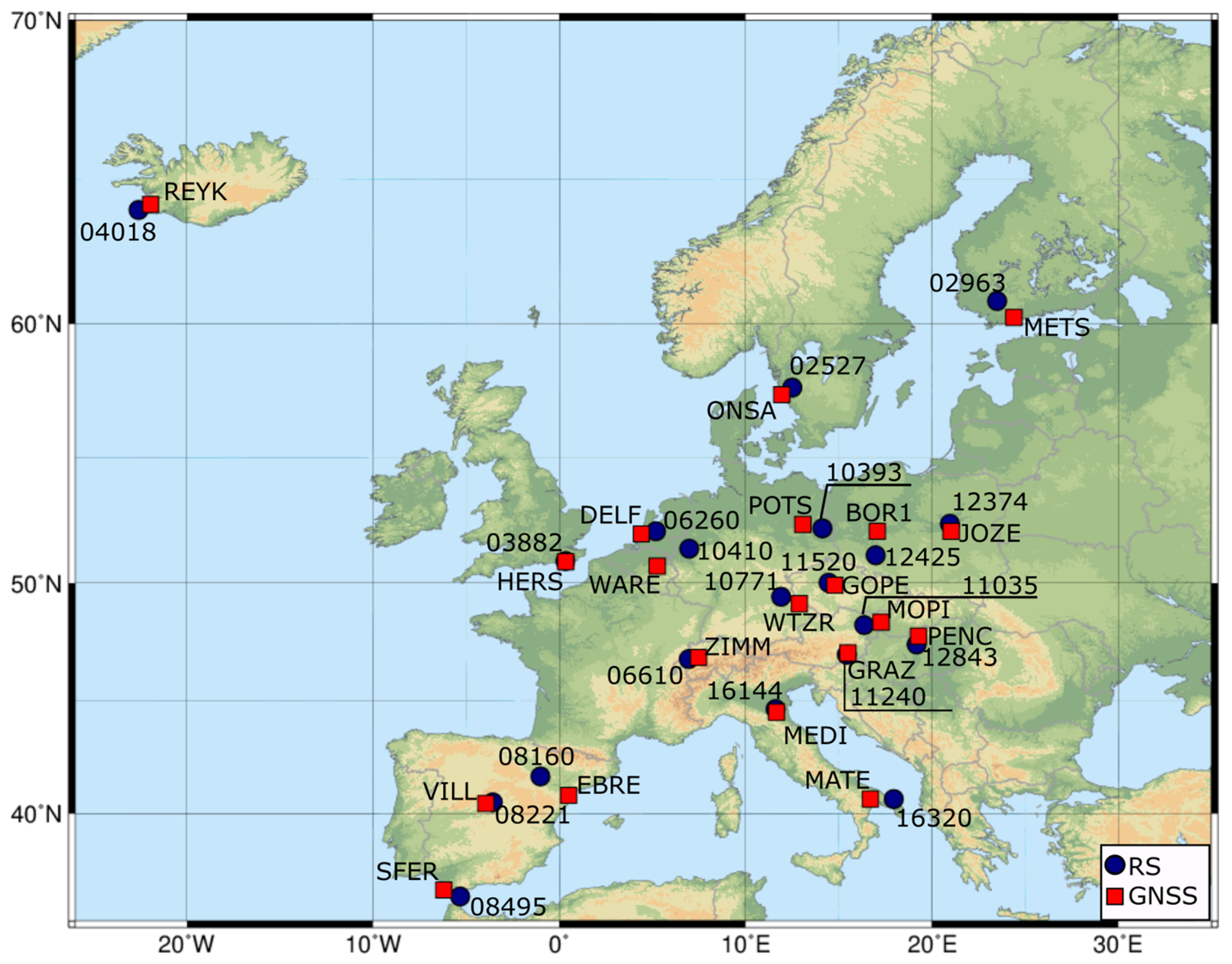
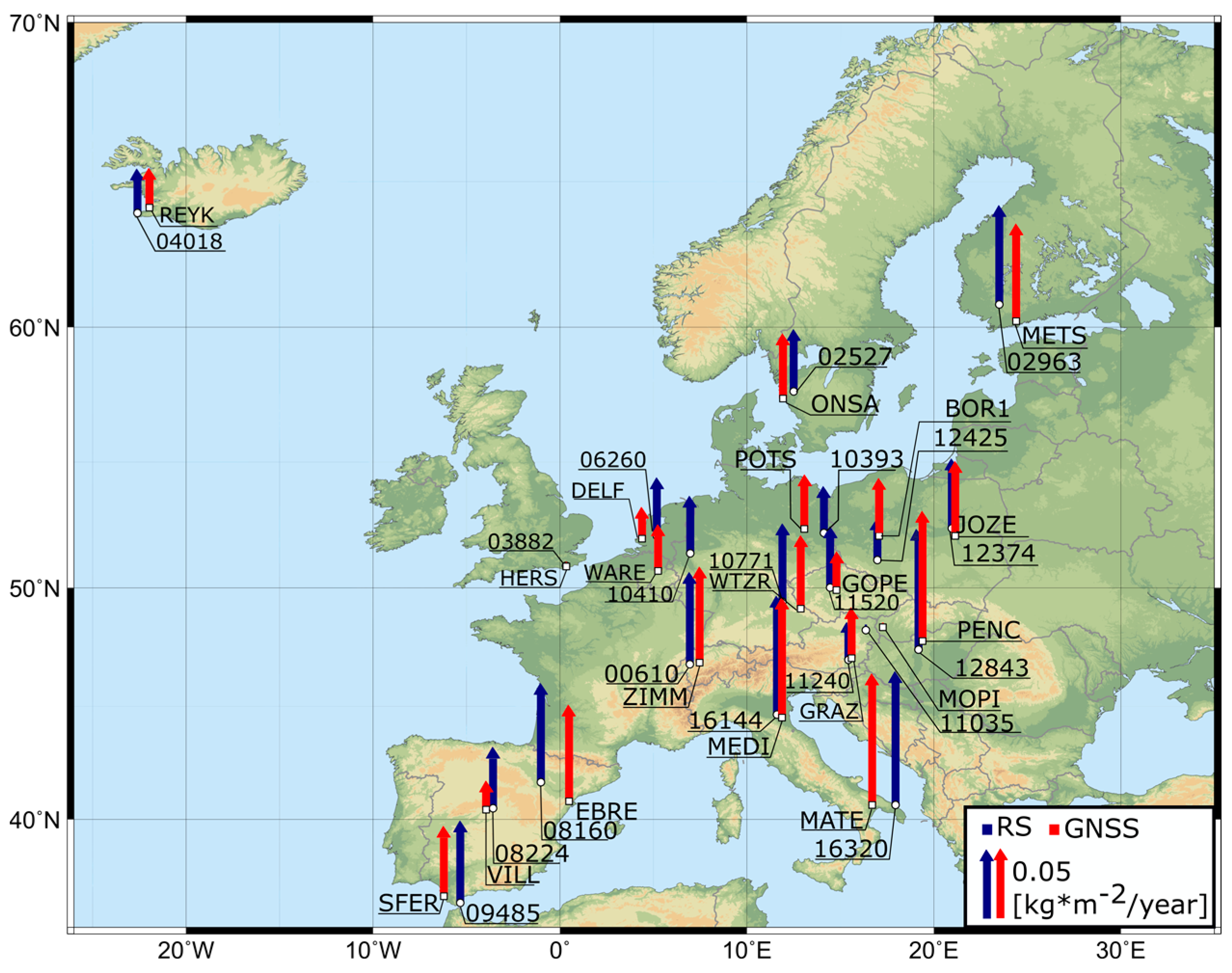
| GNSS Station | RS Station | Approx. Distance [km] | Δh [m] |
|---|---|---|---|
| BOR1 (Borowiec, Poland) | 12425 (Wroclaw, Poland) | 130 | −27 |
| DELF (Delft, Netherlands) | 06260 (De Bilt, Netherlands) | 55 | 29 |
| EBRE (Roquetes, Spain) | 08160 (Zaragoza, Spain) | 147 | −200 |
| GOPE (Ondrejov, Czech Rep.) | 11520 (Praha, Czech Rep.) | 27 | 244 |
| GRAZ (Graz, Austria) | 11240 (Graz, Austria) | 9 | 144 |
| HERS (Hailsham, Great Britain) | 03882 (Herstmonceux, Great Britain) | 4 | −21 |
| JOZE (Jozefoslaw, Poland) | 12374 (Legionowo, Poland) | 34 | 14 |
| MATE (Matera, Italy) | 16320 (Brindisi, Italy) | 110 | 480 |
| MEDI (Medicina, Italy) | 16144 (Pietro Capofiume, Italy) | 15 | −1 |
| METS (Kirkkonummi, Finland) | 02963 (Jokioinen, Finland) | 83 | −27 |
| MOPI (Modra-Piesok, Slovakia) | 11035 (Wien, Austria) | 68 | 335 |
| ONSA (Onsala, Sweden) | 02527 (Goteborg, Sweden) | 35 | −155 |
| PENC (Penc, Hungary) | 12843 (Budapest, Hungary) | 41 | 109 |
| POTS (Potsdam, Germany) | 10393 (Lindenberg, Germany) | 74 | −11 |
| REYK (Reykjavik, Iceland) | 04018 (Keflavikurflugvollur, Iceland) | 37 | −27 |
| SFER (San Fernando, Spain) | 08495 (Gibraltar, Spain) | 84 | 36 |
| VILL (Villafranca, Spain) | 08221 (Madrid, Spain) | 32 | −38 |
| WARE (Waremme, Belgium) | 10410 (Essen, Germany) | 145 | −11 |
| WTZR (Bad Koetzting, Germany) | 10771 (Kuemmersbruck, Germany) | 78 | 201 |
| ZIMM (Zimmerwald, Switzerland) | 06610 (Payerne, Switzerland) | 40 | 416 |
| RS Station | (RS-Era-Interim) | (RS-Era-Interim) | ||||||
|---|---|---|---|---|---|---|---|---|
[hPa] | [hPa] | [hPa] | [hPa/year] | [K] | [K] | [K] | [K/year] | |
| 02527 | −0.07 | 0.04 | 0.02 | 0.00 | −0.77 | 0.42 | 0.12 | 0.00 |
| 02963 | −0.06 | 0.02 | 0.01 | 0.00 | −0.59 | 0.44 | 0.09 | 0.00 |
| 03882 | −0.09 | 0.01 | 0.03 | 0.04 | −0.33 | 0.19 | 0.04 | −0.03 |
| 04018 | −1.26 | 0.04 | 0.03 | −0.02 | −0.04 | 0.12 | 0.04 | −0.03 |
| 06260 | −0.60 | 0.01 | 0.03 | 0.03 | −0.53 | 0.28 | 0.03 | 0.01 |
| 06610 | −0.64 | 0.09 | 0.05 | 0.01 | 1.61 | 0.29 | 0.15 | 0.00 |
| 08160 | −0.66 | 0.12 | 0.08 | −0.01 | 1.71 | 0.27 | 0.17 | −0.04 |
| 08221 | 1.07 | 0.15 | 0.04 | 0.01 | 0.95 | 0.25 | 0.04 | −0.02 |
| 08495 | 0.29 | 0.38 | 0.10 | 0.04 | −0.22 | 0.38 | 0.03 | −0.01 |
| 10393 | 0.15 | 0.14 | 0.07 | −0.02 | −0.84 | 0.39 | 0.03 | 0.00 |
| 10410 | 0.91 | 0.03 | 0.04 | −0.02 | −0.90 | 0.41 | 0.02 | 0.03 |
| 10771 | 0.89 | 0.03 | 0.02 | −0.03 | −0.47 | 0.37 | 0.09 | 0.00 |
| 11035 | −0.20 | 0.13 | 0.04 | 0.00 | 0.20 | 0.44 | 0.12 | −0.02 |
| 11240 | 0.09 | 0.24 | 0.07 | −0.03 | 0.34 | 0.51 | 0.05 | −0.01 |
| 11520 | 0.59 | 0.03 | 0.03 | 0.00 | −0.06 | 0.33 | 0.10 | −0.01 |
| 12374 | 0.20 | 0.02 | 0.02 | 0.01 | −0.25 | 0.41 | 0.12 | −0.02 |
| 12425 | −0.45 | 0.10 | 0.03 | 0.01 | −0.10 | 0.47 | 0.07 | 0.00 |
| 12843 | −0.47 | 0.07 | 0.01 | 0.05 | −0.25 | 0.38 | 0.11 | −0.02 |
| 16144 | 0.56 | 0.07 | 0.13 | 0.01 | −0.04 | 0.31 | 0.18 | −0.01 |
| 16320 | 0.53 | 0.20 | 0.15 | 0.03 | −0.85 | 0.42 | 0.08 | 0.00 |
| abs mean | 0.49 | 0.10 | 0.05 | 0.02 | 0.55 | 0.35 | 0.08 | 0.01 |
| RS Station | [K] | [m] | [kg m−2] | [kg m−2] | [kg m−2] | [kg m−2/year] |
|---|---|---|---|---|---|---|
| 02527 | 270.58 | 0.085 | −0.06 | 0.03 | 0.01 | 0.000 |
| 02963 | 268.87 | 0.078 | −0.05 | 0.03 | 0.01 | 0.000 |
| 03882 | 274.59 | 0.108 | −0.05 | 0.02 | 0.01 | 0.012 |
| 04018 | 268.76 | 0.075 | −0.44 | 0.02 | 0.01 | −0.008 |
| 06260 | 273.88 | 0.104 | −0.24 | 0.02 | 0.01 | 0.011 |
| 06610 | 273.35 | 0.096 | −0.14 | 0.05 | 0.03 | 0.004 |
| 08160 | 278.64 | 0.105 | −0.14 | 0.06 | 0.04 | −0.006 |
| 08221 | 277.17 | 0.088 | 0.43 | 0.07 | 0.02 | 0.003 |
| 08495 | 282.10 | 0.122 | 0.09 | 0.16 | 0.04 | 0.014 |
| 10393 | 272.56 | 0.099 | 0.01 | 0.07 | 0.03 | −0.007 |
| 10410 | 273.08 | 0.099 | 0.27 | 0.03 | 0.02 | −0.005 |
| 10771 | 272.06 | 0.092 | 0.29 | 0.03 | 0.01 | −0.011 |
| 11035 | 273.81 | 0.109 | −0.06 | 0.07 | 0.02 | −0.001 |
| 11240 | 273.07 | 0.107 | 0.05 | 0.12 | 0.03 | −0.011 |
| 11520 | 272.50 | 0.098 | 0.20 | 0.03 | 0.02 | −0.001 |
| 12374 | 272.26 | 0.098 | 0.06 | 0.03 | 0.01 | 0.002 |
| 12425 | 272.53 | 0.100 | −0.16 | 0.06 | 0.01 | 0.004 |
| 12843 | 274.01 | 0.106 | −0.18 | 0.05 | 0.01 | 0.017 |
| 16144 | 277.18 | 0.119 | 0.20 | 0.05 | 0.06 | 0.003 |
| 16320 | 279.39 | 0.118 | 0.13 | 0.10 | 0.06 | 0.011 |
| Absolute mean | 0.16 | 0.05 | 0.02 | 0.006 | ||
© 2018 by the authors. Licensee MDPI, Basel, Switzerland. This article is an open access article distributed under the terms and conditions of the Creative Commons Attribution (CC BY) license (http://creativecommons.org/licenses/by/4.0/).
Share and Cite
Baldysz, Z.; Nykiel, G.; Figurski, M.; Araszkiewicz, A. Assessment of the Impact of GNSS Processing Strategies on the Long-Term Parameters of 20 Years IWV Time Series. Remote Sens. 2018, 10, 496. https://doi.org/10.3390/rs10040496
Baldysz Z, Nykiel G, Figurski M, Araszkiewicz A. Assessment of the Impact of GNSS Processing Strategies on the Long-Term Parameters of 20 Years IWV Time Series. Remote Sensing. 2018; 10(4):496. https://doi.org/10.3390/rs10040496
Chicago/Turabian StyleBaldysz, Zofia, Grzegorz Nykiel, Mariusz Figurski, and Andrzej Araszkiewicz. 2018. "Assessment of the Impact of GNSS Processing Strategies on the Long-Term Parameters of 20 Years IWV Time Series" Remote Sensing 10, no. 4: 496. https://doi.org/10.3390/rs10040496
APA StyleBaldysz, Z., Nykiel, G., Figurski, M., & Araszkiewicz, A. (2018). Assessment of the Impact of GNSS Processing Strategies on the Long-Term Parameters of 20 Years IWV Time Series. Remote Sensing, 10(4), 496. https://doi.org/10.3390/rs10040496