



Journal Menu
► ▼ Journal Menu-
- Remote Sensing Home
- Aims & Scope
- Editorial Board
- Reviewer Board
- Topical Advisory Panel
- Photography Exhibition
- Instructions for Authors
- Special Issues
- Topics
- Sections & Collections
- Article Processing Charge
- Indexing & Archiving
- Editor’s Choice Articles
- Most Cited & Viewed
- Journal Statistics
- Journal History
- Journal Awards
- Society Collaborations
- Conferences
- Editorial Office
Journal Browser
► ▼ Journal BrowserNeed Help?
Announcements
7 March 2023
Displaying Co-Authors’ Email Addresses on the Webpage of Published Papers
MDPI is pleased to announce that we now display the co-authors’ email addresses in addition to the corresponding author’s email address on the webpage of published papers, protected by Captcha. For more information about this change, please visit the journal’s instructions for authors page.
We believe this change will facilitate academic discussions and advance our cause of open science and research. The corresponding authors are responsible for communicating with their co-authors and indicating in our system (https://susy.mdpi.com/) if co-authors would prefer for their email addresses not to be displayed.
22 February 2023
Meet Us at the 2023 AAG Annual Meeting, 23–27 March 2023, Denver, USA

Conference: 2023 AAG Annual Meeting
Date: 23–27 April 2023
Location: Denver, USA
MDPI will be attending the 2023 AAG Annual Meeting as an exhibitor, and we welcome researchers from different backgrounds to visit and share their latest ideas with us.
This conference is organized by the American Association of Geographers (AAG). The theme of the meeting is “Toward More Just Geographies”. At the meeting, specialists will share and discuss the latest in research and applications in geography, sustainability, and GIScience.
The following MDPI journals will be represented:
- Remote Sensing (leading journal);
- Sustainability (leading journal);
- IJGI;
- Hydrology;
- Land;
- Water;
- Earth;
- Atmosphere;
- IJERPH;
- Fire;
- Oceans;
- GeoHazards;
- Coasts;
- Geomatics.
Remote Sensing (ISSN: 2072-4292, IF: 5.349) publishes regular research papers, reviews, technical notes and communications covering all aspects of remote sensing science, from sensor design and validation/calibration to its application in geosciences, environmental sciences, ecology, and civil engineering. The aim is to publish novel/improved methods/approaches and/or algorithms of remote sensing to benefit the community, open to everyone in need of them.
Sustainability (ISSN: 2071-1050, IF: 3.889) encourages experts to publish their experimental, computational and theoretical research on sustainability. This encompasses topics related to social sciences, natural and applied science and engineering, in order to enable the application and development of sustainability.
If you are planning to attend this conference, please do not hesitate to start an online conversation with us. Our delegates look forward to meeting you in person and answering any questions that you may have. For more information about the conference, please visit the following website: https://www.aag.org/events/aag2023/.
16 February 2023
Increasing Visibility for Preprints.org – Clarivate adds the Preprint Citation Index to the Web of Science

On 9 February 2023, Clarivate, a global leader in providing trusted insights and analytics, added the Preprint Citation Index to the Web of Science platform, streamlining the research process by allowing researchers to locate and link to preprints alongside other trusted content in the database.
The Preprint Citation Index will act as a bridge to connect cutting-edge preprints with peer-reviewed journal articles published within the Web of Science Core Collection. Alerts can be easily set to monitor new research across several repositories and authors will also be able to include preprints on their Web of Science Research Profile to more accurately display their various research outputs.
As of its launch, the Preprint Citation Index will provide nearly two million preprints from various repositories, including MDPI’s own Preprints.org.
MDPI's Preprints Platform – Preprints.org
To advance Open Science and the fast dissemination of research, MDPI offers researchers a free multidisciplinary preprint platform. Preprints.org accepts submissions from all research areas and offers authors high visibility, permanent archiving, article-level Metrics and immediately citable content by assigning a Digital Object Identifier (DOI) to all preprints.
During submission to any MDPI journal, authors have the option to share their research as a preprint. After an initial screening, the manuscript is available online in 48 hours or less. Once online, preprints can be downloaded, shared, commented on, and cited, providing authors maximum visibility.
We invite you to join the ranks of the over 100k researchers using Preprints.org and share your research.
For more information, please visit Preprints.org.
22 December 2022
Special Issue Mentor Program
We are pleased to announce the launch of a new initiative—the MDPI Special Issue Mentor Program.
This program will enable early career researchers (who must hold a Ph.D. in a related field) to experience editing a Special Issue in MDPI journals, under the mentorship of our experienced Editorial Board Members or other experienced scientists. The mentor program will provide an excellent opportunity for early career scientists to gain editorial experience, and to cultivate their ability to edit scientific research.
The mentee’s responsibilities include:
- Proposing a Special Issue title and assisting the mentor in preparing a summary (around 200–400 words) and 3–10 keywords describing the background, importance, and goal of the Issue;
- Writing a brief promotion plan for the Special Issue;
- Preparing a list of scholars who may be interested in the Issue and personally e-mailing invitations on behalf of Guest Editors;
- Writing an editorial for the online Special Issue together with the mentor.
The mentor’s responsibilities include:
- Conducting a final check before the Special Issue is published online;
- Performing editorial control of the Special Issue and quality control of the publications, both of which must be carried out in a timely manner;
- Providing suggestions to younger scholars if they have any doubts or concerns regarding submissions;
- Organizing video calls with young scholars and the Editorial Office regularly to discuss problems and improvement suggestions for the Special Issue;
- Making and submitting decisions regarding submissions with the assistance of mentees.
Certificates and awards:
After the Special Issue closes, the Editorial Office will provide official certificates for all the mentors and early career researchers.
If you are interested in this opportunity, please send your Special Issue proposal to the Editorial Office of a journal you choose, and we will discuss the process (i.e., mentor collaboration, Special Issue topic feasibility analysis, etc.) in further detail. The full list of MDPI journals is as follows: https://www.mdpi.com/about/journals.
In addition to the new Special Issue Mentor Program, we will continue to welcome all Special Issue proposals focusing on hot research topics.
14 December 2022
"Thanks a Million!" – One Million Articles Published in MDPI Journals
MDPI has just become the first open access (OA) publisher to reach the milestone of one million articles published. That is one million articles freely available to all, to circulate and build upon! We are proud to share this special moment with the global scientific community.
This landmark has been reached thanks to the immeasurable support of more than 600,000 expert reviewers, 66,000 editorial board members and 6700 hard-working colleagues across MDPI’s global offices.
Within more than 25 years of publishing, our journals received 2.1 million manuscripts and generated 4.6 million peer review reports to get to one million papers published.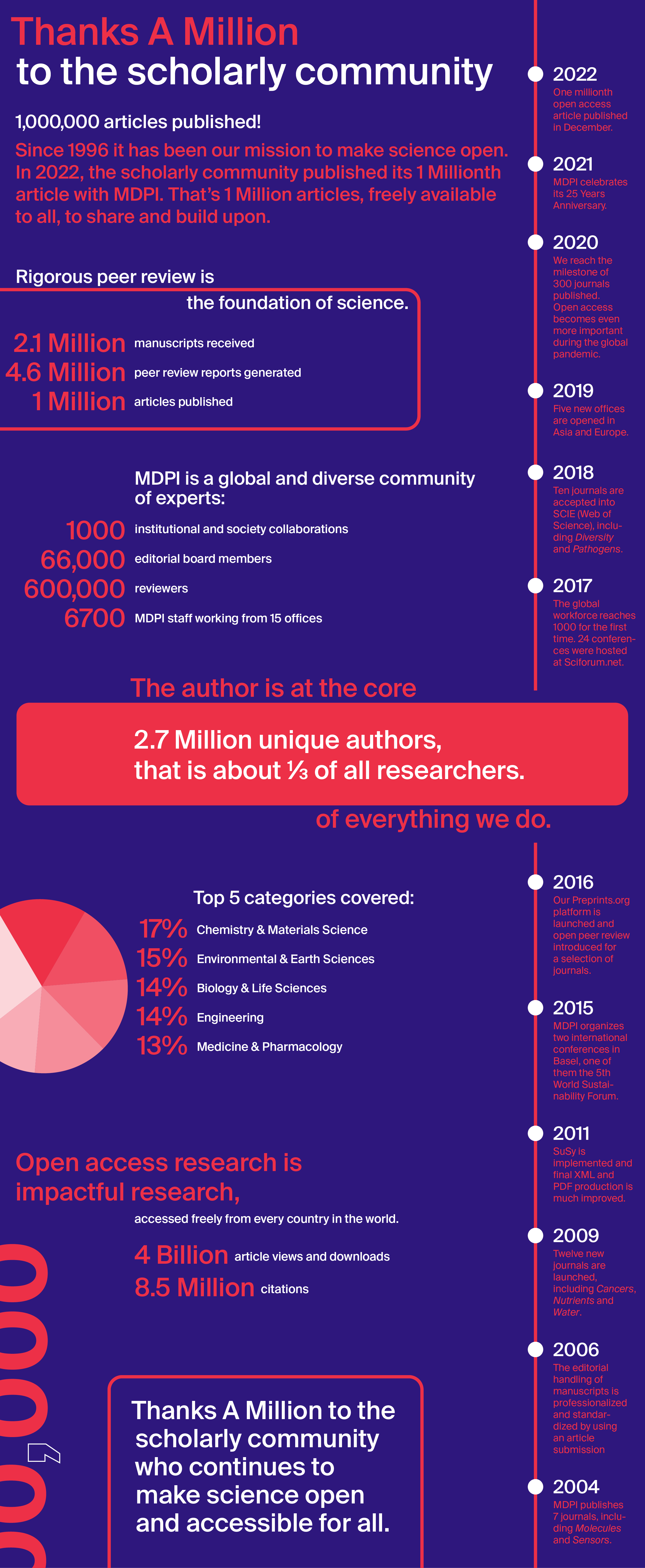
Reaching the milestone of one million articles published reinforces our mission to remove any existing barriers and to make scientific research accessible to all. Since its inception, MDPI’s goal has been to create reliable processes to make science open. This is a path towards facilitating the dissemination of novel insights in scientific communities.
Regular feedback from authors and reviewers shows that our service is greatly appreciated and needed. At the same time, the feedback helps us identify areas for further improvement.
As it stands, a significant share of published research findings remain closed access. More than half of the content published with the most well-known legacy publishers stays behind a paywall, and that is not including articles published in hybrid OA journals, or made available months or years after publication.
A new policy announced by the US administration in August 2022 requires that, as of January 2026, all US federally funded research be made freely and immediately available after publication. While the new policy does not mandate articles be published under an open access license, it is aligned with the open access movement in removing all barriers to research. Similarly, some of the most advanced research institutions in the world intend to have all funded research articles published in open access by 2025.
MDPI is proud to be the leading agent of the transition to open access.
"Thanks a Million" to all the contributors!
8 December 2022
MDPI Sustainability Foundation: New Look and Nominations for the 2023 Sustainability Awards Now Open
We are pleased to announce that the website of the MDPI Sustainability Foundation has been revamped! For the past couple of months, our UX UI team and front-end developers have been working hard to launch the website in time for the opening of the Sustainability Awards nominations.
The website is not the only thing that has had a remodeling. Indeed, the format of the Emerging Sustainability Leader Award (ESLA) has been updated. ESLA is now a competition open to individual researchers or start-ups founded by researchers under the age of 35. Nominee applications will go through 2 rounds of selection until the final 3 are decided. The finalists will then be invited to give pitch presentations during the Award Ceremony to win either first place (10,000 USD) or runner-up (2 x 5000 USD).
The World Sustainability Award, on the other hand, remains the same: a total prize money of 100,000 USD is up for grabs by senior individual researchers or groups of researchers from the international research community.
Nominations for both the World Sustainability Award and the Emerging Sustainability Leader award are now open! Check out our new website for more information on how to nominate.
2 December 2022
Editorial Board Members from Remote Sensing Featured among the World’s Top 2% Scientists in 2022

The list of the World’s Top 2% Scientists in 2022 was released by scientists at Stanford on 10 October 2022 to recognize influential scholars around the world. According to the statistics, 220 Remote Sensing Editorial Board Members from different research fields have been selected for the list, which recognizes them for their high-quality research results and outstanding contributions in their fields of expertise.
For the details of the listed scholars, please see the full list below:
| Name | Affiliation |
| Prof. Dr. Adrian Stern | Ben-Gurion University, Israel |
| Dr. Akram Al-Hourani | RMIT University, Australia |
| Dr. Alemu Gonsamo | McMaster University, Canada |
| Dr. Alessandro Matese | 1. Institute of BioEconomy, National Research Council (CNR-IBE), Italy; 2. Geosystems Research Institute, Mississippi State University, USA |
| Prof. Dr. Alexander Brenning | Friedrich Schiller University Jena, Germany |
| Dr. Alexander Kokhanovsky | German Research Centre for Geosciences, Germany |
| Prof. Dr. Alfredo Huete | University of Technology Sydney, Australia |
| Dr. Amin Beiranvand Pour | Universiti Malaysia Terengganu (UMT), Malaysia |
| Dr. Ana I. de Castro | Instituto Nacional de Investigacion y Tecnologia Agraria y Alimentaria, Spain |
| Prof. Dr. Anatoly Gitelson | 1. Israel Institute of Technology, Israel; 2. University of Nebraska - Lincoln, USA |
| Prof. Dr. Andrea Garzelli | University of Siena, Italy |
| Prof. Dr. Andreas Reigber | German Aerospace Center (DLR), Germany |
| Prof. Dr. Andrew Skidmore | University of Twente, the Netherlands |
| Prof. Dr. Andrzej Stateczny | Gdansk Technical University, Poland |
| Dr. Anup Basu | University of Alberta, Canada |
| Dr. Arko Lucieer | University of Tasmania, Australia |
| Prof. Dr. Arturo Sanchez-Azofeifa | University of Alberta, Canada |
| Dr. Ashraf Dewan | Curtin University, Australia |
| Prof. Dr. Assefa M. Melesse | Florida International University, USA |
| Prof. Dr. Atul Jain | University of Illinois, USA |
| Dr. Augusto Getirana | 1. NASA Goddard Space Flight Center, USA; 2. Science Applications International Corporation, USA |
| Dr. Bailang Yu | East China Normal University, China |
| Prof. Dr. Long Xiao | China University of Geosciences, China |
| Prof. Dr. Bas van Wesemael | Université Catholique de Louvain, Belgium |
| Prof. Dr. Bisheng Yang | Wuhan University, China |
| Dr. Bo Du | Wuhan University, China |
| Dr. Brian Alan Johnson | Natural Resources and Ecosystem Services, Institute for Global Environmental Strategies, Japan |
| Dr. Bruno Aiazzi | Institute of Applied Physics "Nello Carrara", National Research Council of Italy, Italy |
| Prof. Dr. Bruno Basso | Michigan State University, USA |
| Dr. Carlos Alberto Silva | University of Florida, USA |
| Prof. Dr. Carmine Serio | University of Basilicata, Italy |
| Dr. Chandra Giri | United States Environmental Protection Agency, USA |
| Prof. Dr. Changshan Wu | University of Wisconsin-Milwaukee, USA |
| Prof. Dr. Chaowei Yang | George Mason University, USA |
| Dr. Chengbin Deng | State University of New York at Binghamton, USA |
| Dr. Chris Roelfsema | The University of Queensland, Australia |
| Prof. Dr. Christian Wöhler | TU Dortmund University, Germany |
| Dr. Christopher D. Elvidge | NOAA National Geophysical Data Center, USA |
| Prof. Dr. Christopher Small | Columbia University, USA |
| Dr. Claudia Kuenzer | German Aerospace Center, DLR, Germany |
| Dr. Claudio Persello | University of Twente, the Netherlands |
| Dr. Clement Albergel | ESA - European Space Agency, UK |
| Dr. Clement Atzberger | University of Natural Resources and Life Sciences, Austria |
| Prof. Dr. Conghe Song | University of North Carolina at Chapel Hill, USA |
| Prof. Dr. Costas Varotsos | National and Kapodistrian University of Athens, Greece |
| Prof. Dr. Danfeng Hong | The Key Laboratory of Digital Earth Science, Aerospace Information Research Institute, Chinese Academy of Sciences, China |
| Prof. Dr. Danilo Orlando | Università degli Studi “Niccolò Cusano”, Italy |
| Prof. Dr. Danlin Yu | Montclair State University, USA |
| Dr. Dar Roberts | University of California, USA |
| Dr. David M. Johnson | USDA / National Agricultural Statistics Service, USA |
| Prof. Dr. David Skole | Michigan State University, USA |
| Dr. David W. Johnston | Duke University, USA |
| Prof. Dr. Debra F. Laefer | 1. New York University, USA; 2. University College Dublin, Ireland |
| Prof. Dr. Dehua Mao | Northeast Institute of Geography and Agroecology, Chinese Academy of Sciences, China |
| Prof. Dr. Dengsheng Lu | Fujian Normal University, China |
| Dr. Dino Ienco | French National Institute for Agriculture, Food and Environment, Department of Territories, France |
| Dr. Dominik Seidel | University of Göttingen, Germany |
| Dr. Dominique Arrouays | INRAE, InfoSol Unit, France |
| Dr. Edoardo Pasolli | University of Naples Federico II, Italy |
| Dr. Eileen H. Helmer | United States Department of Agriculture, USA |
| Prof. Dr. Eric Small | University of Colorado, USA |
| Dr. Eric Vermote | NASA Goddard Space Flight Center, USA |
| Dr. Eugenio Sansosti | Istituto per il Rilevamento Elettromagnetico dell’Ambiente (IREA), National Research Council (CNR) of Italy, Italy |
| Dr. Eyal Ben-Dor | Tel Aviv University (TAU), Israel |
| Prof. Dr. Filippo Catani | University of Florence, Italy |
| Prof. Dr. Francesco Martellotta | Politecnico di Bari, Italy |
| Dr. Francesco Mattia | National Research Council of Italy (CNR), Institute for Electromagnetic Sensing of the Environment (IREA), Italy |
| Dr. Francesco Nex | University of Twente, the Netherlands |
| Dr. Francesco Soldovieri | National Research Council of Italy (CNR), Institute for Electromagnetic Sensing of the Environment (IREA), Italy |
| Dr. Frédéric Frappart | INRAE, Université de Bordeaux, France |
| Prof. Dr. Fumio Yamazaki | 1. Chiba University, Japan; 2. National Research Institute for Earth Science and Disaster Resilience (NIED), Japan |
| Dr. Gabriel B. Senay | USGS EROS Center, North Central Climate Adaptation Science Center, USA |
| Dr. Gemine Vivone | Institute of Methodologies for Environmental Analysis, CNR-IMAA, Italy |
| Dr. Geoffrey Parker | Smithsonian Environmental Research Center, USA |
| Dr. George P. Petropoulos | Harokopio University of Athens, Greece |
| Dr. George Xian | USGS Center for Earth Resources Observation and Science, USA |
| Dr. Gianpaolo Balsamo | European Centre for Medium-range Weather Forecasts, UK |
| Dr. Gianpaolo Coro | National Research Council of Italy (CNR), Institute of Information Science and Technologies "Alessandro Faedo" (ISTI-CNR), Italy |
| Prof. Dr. Giles Foody | University of Nottingham, UK |
| Prof. Dr. Giuseppe Modica | Università degli Studi Mediterranea di Reggio Calabria, Italy |
| Prof. Dr. Greg Okin | University of California, USA |
| Dr. Guillaume Ramillien | Géosciences Environnement Toulouse, CNRS/IRD/UPS, Observatoire Midi-Pyrénées, France |
| Dr. Guoqing Zhou | 1. Guilin Iniversity of Technology, China; 2. Tianjin University, China |
| Dr. Gwanggil Jeon | Incheon National University, South Korea |
| Dr. Hamish D. Pritchard | British Antarctic Survey, UK |
| Prof. Dr. Hongtao Duan | Nanjing Institute of Geography and Limnology, Chinese Academy of Sciences, China |
| Prof. Dr. Hubert Hasenauer | BOKU University of Natural Resources and Life Sciences, Austria |
| Prof. Dr. Ignacio A. Ciampitti | Kansas State University, USA |
| Prof. Dr. Inge Sandholt | Technical University of Denmark, Denmark |
| Dr. Ira Leifer | Bubbleology Research International, USA |
| Prof. Dr. Isabel Trigo | (IPMA) EUMETSAT Land Surface Analysis - Satellite Application, Facility Project Manager Rua C ao Aeroporto, Portugal |
| Prof. Dr. Ismail Gultepe | Ontario Technical University, Canada |
| Prof. Dr. James Campbell | Virginia Polytechnic Institute and State University (Virginia Tech), USA |
| Prof. Dr. James Carton | University of Maryland, USA |
| Prof. Dr. Janet E. Nichol | University of Sussex, UK |
| Dr. Janne Heiskanen | University of Helsinki, Finland |
| Prof. Dr. Jan-Peter Muller | UCL Mullard Space Science Laboratory, UK |
| Dr. Jean-Christophe Calvet | CNRM, Meteo-France, France |
| Dr. Jean-Louis Roujean | CESBIO, Toulouse, France |
| Prof. Dr. Jeffrey F. Kelly | Plains Institute, University of Oklahoma, USA |
| Prof. Dr. Jianghui Geng | Wuhan University, China |
| Prof. Dr. Jianxi Huang | China Agricultural University, China |
| Prof. Dr. Jie Shan | Purdue University, USA |
| Dr. Jin Wu | The University of Hong Kong, Hong Kong, China |
| Dr. Jochem Verrelst | University of Valencia, Spain |
| Prof. Dr. Jörg Bendix | Laboratory for Climatology and Remote Sensing, Phillips- University of Marburg, Germany |
| Prof. Dr. Jose Moreno | Universitat de València, Spain |
| Prof. Dr. Josep Peñuelas | Global Ecology Unit CREAF‐CSIC‐UAB, Spain |
| Prof. Dr. Juha Hyyppä | Finish Geospatial Research Institute, Finland |
| Prof. Dr. Jungho Im | Ulsan National Institute of Science and Technology, South Korea |
| Prof. Dr. Junjun Jiang | Harbin Institute of Technology, China |
| Dr. Junshi Xia | Geoinformatics Unit, RIKEN Center for Advanced Intelligence Project, Japan |
| Dr. Justin Morgenroth | University of Canterbury, New Zealand |
| Prof. Dr. Kaicun Wang | Peking University, China |
| Dr. Kim Calders | Ghent University, Belgium |
| Dr. Kohei Arai | Saga University, Japan |
| Dr. Konstantinos Topouzelis | University of the Aegean, Greece |
| Dr. Konstantinos X. Soulis | Agricultural University of Athens, Greece |
| Dr. Krzysztof Stereńczak | Forest Research Institute, Poland |
| Prof. Dr. Lalit Kumar | East Coast Geospatial Consultants, Australia |
| Prof. Dr. Lefei Zhang | Wuhan University, China |
| Dr. Leonor Calvo | Universidad de León, Spain |
| Prof. Dr. Liping Di | George Mason University, USA |
| Prof. Dr. Lizhe Wang | Institute of Remote Sensing and Digital Earth, Chinese Academy of Sciences, China |
| Dr. Luca Brocca | National Research Council, Research Institute for Geo-Hydrological Protection, Italy |
| Prof. Dr. Lunche Wang | China University of Geosciences, China |
| Prof. Dr. Marco Scaioni | Politecnico di Milano, Italy |
| Dr. Martin Mlynczak | NASA Langley Research Center, USA |
| Prof. Dr. Massimiliano Pieraccini | University of Florence, Italy |
| Prof. Dr. Massimo Menenti | Aerospace Information Research Institute, Chinese Academy of Sciences, State Key Laboratory of Remote Sensing Science, China |
| Dr. Matthew Clarke | Sonoma State University, USA |
| Prof. Dr. Matthew McCabe | King Abdullah University of Science and Technology, Saudi Arabia |
| Dr. Mauro Dalla Mura | GIPSA-Lab, Grenoble Institute of Technology, France |
| Dr. Mehrez Zribi | Universite Paul Sabatier Toulouse III, Italy |
| Prof. Dr. Miaogen Shen | Beijing Normal University, China |
| Dr. Michael H. F. Wilkinson | University of Groningen, the Netherlands |
| Prof. Dr. Michael Lefsky | Colorado State University, USA |
| Prof. Dr. Michael Vohland | Leipzig University, Germany |
| Dr. Michele Meroni | European Commission, Joint Research Centre, Directorate D – Sustainable Resources, Food Security Unit, Italy |
| Dr. Mohammad Awrangjeb | Griffith University, Australia |
| Dr. Nancy E. Grulke | USDA Forest Service Pacific Northwest Research Station, USA |
| Dr. Nicolas Baghdadi | University of Montpellier, France |
| Prof. Dr. Noam Levin | The Hebrew University of Jerusalem, Israel |
| Dr. Okan Yurduseven | Queen’s University Belfast, UK |
| Dr. Oleg Dubovik | Laboratoire d’Optique Atmosphérique, CNRS/Universite Lille, France |
| Dr. Olivier Merlin | CESBIO, Université de Toulouse, France |
| Dr. Pamela Nagler | U.S. Geological Survey, Southwest Biological Science Center, USA |
| Dr. Parth Sarathi Roy | Sustainable Landscapes and Restoration, World Resources Institute India, India |
| Dr. Paul Honeine | LITIS Lab, Université de Rouen Normandie, France |
| Prof. Dr. Paul Scheunders | Vision Lab, University of Antwerp (CDE), Belgium |
| Dr. Paulo Pereira | Environmental Management Laboratory, Mykolas Romeris University, Lithuania |
| Prof. Dr. L. Monika Moskal | University of Washington (UW), USA |
| Dr. Peng Fu | Harrisburg University, USA |
| Prof. Dr. Peng Jia | Wuhan University, China |
| Prof. Dr. Pinliang Dong | University of North Texas, USA |
| Prof. Dr. Piotr Samczynski | Warsaw University of Technology, Poland |
| Prof. Dr. Prem Prakash Jayaraman | Swinburne University of Technology, Australia |
| Prof. Dr. Qi Wang | Northwestern Polytechnical University, China |
| Dr. Qiangqiang Yuan | Wuhan University, China |
| Prof. Dr. Qihao Weng | Indiana State University, USA |
| Prof. Dr. Qile Zhao | Wuhan University, China |
| Dr. Qinghua Guo | State Key Laboratory of Vegetation and Environmental Change, Institute of Botany, Chinese Academy of Sciences, China |
| Prof. Dr. Qiuhong Tang | Key Laboratory of Water Cycle and Related Land Surface Processes, Institute of Geographic Sciences and Natural Resources Research, Chinese Academy of Sciences, China |
| Dr. Qiusheng Wu | University of Tennessee, USA |
| Dr. Ralph R. Ferraro | NOAA/NESDIS/Center for Satellite Applications and Research (STAR), USA |
| Prof. Dr. Raphael M. Kudela | University of California, USA |
| Dr. Robert Brewin | University of Exeter (Penryn Campus), UK |
| Dr. Robert Treuhaft | Jet Propulsion Laboratory, California Institute of Technology, USA |
| Dr. Ronald C. Estoque | Forestry and Forest Products Research Institute (FFPRI), Japan |
| Dr. Ronan Fablet | Institut Mines-Télécom, Telecom-Bretagne, France |
| Dr. Rosa Lasaponara | CNR-IMAA (Institute of Environmental Analysis), Italy |
| Prof. Dr. Ruiliang Pu | University of South Florida, USA |
| Prof. Dr. Salah Bourennane | Ecole Centrale de Marseille, France |
| Dr. Sandra Eckert | University of Bern, Switzerland |
| Prof. Dr. Sébastien Lefèvre | IRISA, Université Bretagne Sud, Campus de Tohannic, France |
| Dr. Seyed Amir Naghibi | Lund University, Sweden |
| Dr. Shawn P. Serbin | Brookhaven National Laboratory, USA |
| Prof. Dr. Shuanggen Jin | Shanghai Astronomical Observatory, Chinese Academy of Sciences, China |
| Dr. Shubha Sathyendranath | Plymouth Marine Laboratory, UK |
| Prof. Dr. Shuguang Liu | Central South University of Forestry and Technology, China |
| Prof. Dr. Shunichi Koshimura | Tohoku University, Japan |
| Prof. Dr. Simon Jones | RMIT University, Australia |
| Prof. Dr. Soe W. Myint | Arizona State University, USA |
| Dr. Soo Chin Liew | National University of Singapore, Singapore |
| Prof. Dr. Stefania Bonafoni | University of Perugia, Italy |
| Dr. Stefano Mattoccia | University of Bologna, Italy |
| Dr. Stefano Tebaldini | Politecnico di Milano, Department of Information, Electronics, and Bioengineering, Italy |
| Prof. Dr. Stuart Phinn | University of Queensland, Australia |
| Prof. Dr. Tamas Sziranyi | Machine Perception Research Laboratory, Hungary |
| Dr. Tao Lei | Shaanxi University of Science and Technology, China |
| Prof. Dr. Thomas Udelhoven | University of Trier, Germany |
| Prof. Dr. Toby N. Carlson | Pennsylvania State University, USA |
| Dr. Tomoaki Miura | University of Hawai‘i at Mānoa, USA |
| Prof. Dr. Valerio Tramutoli | University of Basilicata, Italy |
| Dr. W. Gareth Rees | University of Cambridge, UK |
| Prof. Dr. Weiqi Zhou | State Key Laboratory of Urban and Regional Ecology, Research Center for Eco-Environmental Sciences, Chinese Academy of Sciences, China |
| Prof. Dr. Wenge Ni-meister | Hunter College The City University of New York, USA |
| Prof. Dr. Wenhui Kuang | Key Laboratory of Land Surface Pattern and Simulation, Institute of Geographical Sciences and Natural Resources Research, Chinese Academy of Sciences, China |
| Dr. Wenjiang Huang | Aerospace Information Research Institute, Chinese Academy of Sciences, China |
| Dr. Xia Yao | Nanjing Agricultural University, China |
| Dr. Xian Sun | Aerospace Information Research Institute, Chinese Academy of Sciences, China |
| Prof. Dr. Xiangrong Zhang | Xidian University, China |
| Prof. Dr. Xiaohua Tong | Tongji University, China |
| Dr. Xiaoxiong Xiong | Sciences and Exploration Directorate, NASA Goddard Space Flight Center, USA |
| Dr. Xin Li | Cold and Arid Regions Environmental and Engineering Research Institute, Chinese Academy of Sciences, China |
| Dr. Xuecao Li | China Agricultural University, China |
| Prof. Dr. Yanfei Zhong | Wuhan University, China |
| Prof. Dr. Yang Hong | University of Oklahoma, USA |
| Prof. Dr. Yongjiu Dai | Sun Yat-sen University, China |
| Dr. Yongxiang Hu | NASA Langley Research Center, USA |
| Dr. Yoshio Inoue | University of Tokyo, Japan |
| Dr. Yuanwei Qin | University of Oklahoma, USA |
| Prof. Dr. Yuji Murayama | University of Tsukuba, Japan |
| Prof. Dr. Yunlin Zhang | Nanjing Institute of Geography and Limnology, Chinese Academy of Sciences, China |
| Dr. Yuwei Chen | Finnish Geospatial Research Institute, Finland |
| Dr. Yuxin Miao | University of Minnesota, USA |
| Dr. Zhe Zhu | University of Connecticut, USA |
| Prof. Dr. Zhenhong Li | Chang’an University, China |
| Prof. Dr. Zhenwei Shi | Beihang University, China |
| Prof. Dr. Zhong Lu | Southern Methodist University, USA |
Congratulations to the scholars again!
Source: September 2022 data update for “Updated science-wide author databases of standardized citation indicators”: https://elsevier.digitalcommonsdata.com/datasets/btchxktzyw/4.
2 December 2022
Editorial Board Members from Remote Sensing Featured in the 2022 Highly Cited Researchers List Published by Clarivate
Recently, Clarivate™ revealed its 2022 list of Highly Cited Researchers™—individuals at universities, research institutes and commercial organizations.
The scientists who were selected into this year’s list of Highly Cited Researchers have published highly cited papers in the 11-year period from January 2011 to December 2021, with citation frequency in the top 1% of academic subjects and the same year of publication in the Web of Science™ database. Based on Web of Science Citation data, 6,938 researchers from across the globe who have demonstrated a disproportionate level of significant and broad influence in their chosen field or fields over the last decade have been awarded Highly Cited Researcher 2022 designations. The list is truly global, spanning 69 countries or regions and spread across a diverse range of research sciences and social sciences.
According to statistics, 27 members of the Editorial Board of Remote Sensing (ISSN: 2072-4292) have been selected into the list of Highly Cited Researchers of Clarivate in 2022. They are being recognized for their high-quality scientific research achievements and outstanding contributions to professional fields. The Remote Sensing journal office sincerely congratulates all elected Editorial Board Members and hopes that they continue to have an academically productive relationship with the journal.
| Name | Affiliation |
| Dr. Arko Lucieer | University of Tasmania, Australia |
| Prof. Dr. Atul Jain | University of Illinois Urbana-Champaign, USA |
| Prof. Dr. Bas van Wesemael | Universite Catholique Louvain, Belgium |
| Dr. Bo Du | Wuhan University, China |
| Prof. Dr. Danfeng Hong | Chinese Academy of Sciences, China |
| Prof. Dr. Eric Rignot | University of California Irvine, USA |
| Dr. Gianpaolo Balsamo | European Centre for Medium-Range Weather Forecasts (ECMWF), UK |
| Prof. Dr. Jon Atli Benediktsson | University of Iceland, Iceland |
| Prof. Dr. Junjun Jiang | Harbin Institute of Technology, China |
| Prof. Dr. Lefei Zhang | Wuhan University, China |
| Prof. Dr. Liangpei Zhang | Wuhan University, China |
| Prof. Dr. Licheng Jiao | Xidian University, China |
| Prof. Dr. Xiaoping Liu | Sun Yat-Sen University, China |
| Prof. Dr. Matthew F. McCabe | King Abdullah University of Science & Technology, Saudi Arabia |
| Dr. Naoto Yokoya | University of Tokyo, Japan |
| Prof. Dr. Nicholas C. Coops | University of British Columbia, Canada |
| Dr. Pedram Ghamisi | Helmholtz-Zentrum Dresden-Rossendorf (HZDR), Germany |
| Prof. Dr. Qi Wang | Northwestern Polytechnical University, China |
| Prof. Dr. Qian Du | Mississippi State University, USA |
| Dr. Qiangqiang Yuan | Wuhan University, China |
| Dr. Shutao Li | Hunan University, China |
| Prof. Dr. Weiqi Zhou | Chinese Academy of Sciences, China |
| Prof. Dr. Yang Hong | Tsinghua University, China |
| Prof. Dr. Yu Liu | Peking University, China |
| Dr. Yuanwei Qin | University of Oklahoma System, USA |
| Dr. Yuyu Zhou | Iowa State University, USA |
| Dr. Zhe Zhu | University of Connecticut, USA |
8 November 2022
Meet Us at the 13th China Satellite Navigation Conference, 16–18 November 2022, Beijing, China

Conference: The 13th China Satellite Navigation Conference
Date: 16–18 November 2022
Place: Beijing, China
Sensors (ISSN: 1424-8220) will be attending the 13th China Satellite Navigation Conference as an exhibitor. This meeting will take place from 16 to 18 November in Beijing, China.
The China Satellite Navigation Conference (CSNC) is an open academic exchange platform. It aims to strengthen academic innovation and promote the cooperation and exchange of satellite navigation systems, strengthen technological innovation and promote the engineering construction of satellite navigation systems, strengthen theoretical innovation and promote the progress of satellite navigation theories, and strengthen application innovation and promote the scientific development of satellite navigation industry. The conference has been successfully held for 12 years and has produced a large number of excellent results in academic, technical, theoretical, application, and talent aspects.
The following MDPI journals will be represented:
- Sensors;
- Remote Sensing;
- Atmosphere;
- Aerospace;
- Technologies;
- Drones;
- Signals;
- Smart Cities;
- AI;
- Geomatics.
If you are planning to attend this conference, please do not hesitate to start an online conversation with us (booth #B18). Our delegates look forward to meeting you in person and answering any questions that you may have. For more information about the conference and virtual booth, please visit the following website: https://www.beidou.org/annualmeeting.html.
31 October 2022
Remote Sensing | Editor’s Choice Articles in 2020
We are pleased to invite you to read the Editor’s Choice Articles in Remote Sensing (ISSN: 2072-4292). The list of high-quality and interesting papers that were specifically recommended by our Editorial Board Members can be found at the following link: https://www.mdpi.com/journal/remotesensing/editors_choice. The paper list is as follows:
|
1. “Feasibility of Burned Area Mapping Based on ICESAT−2 Photon Counting Data” |
2. “Potential of Night-Time Lights to Measure Regional Inequality” |
|
3. “Antarctic Supraglacial Lake Detection Using Landsat 8 and Sentinel-2 Imagery: Towards Continental Generation of Lake Volumes” |
4. “Cloud Removal with Fusion of High Resolution Optical and SAR Images Using Generative Adversarial Networks” |
|
5. “Evaluation of Coherent and Incoherent Landslide Detection Methods Based on Synthetic Aperture Radar for Rapid Response: A Case Study for the 2018 Hokkaido Landslides” |
6. “Harmonization of Landsat and Sentinel 2 for Crop Monitoring in Drought Prone Areas: Case Studies of Ninh Thuan (Vietnam) and Bekaa (Lebanon)” |
|
7. “Predicting Forest Cover in Distinct Ecosystems: The Potential of Multi-Source Sentinel-1 and -2 Data Fusion” |
8. “Integrating Remote Sensing and Street View Images to Quantify Urban Forest Ecosystem Services” |
|
9. “Mapping Landslides on EO Data: Performance of Deep Learning Models vs. Traditional Machine Learning Models” |
10. “Comparison of Machine Learning Methods Applied to SAR Images for Forest Classification in Mediterranean Areas” |
|
11. “How Well Do Deep Learning-Based Methods for Land Cover Classification and Object Detection Perform on High Resolution Remote Sensing Imagery?” |
12. “LiCSBAS: An Open-Source InSAR Time Series Analysis Package Integrated with the LiCSAR Automated Sentinel-1 InSAR Processor” |
|
13. “Towards Routine Mapping of Shallow Bathymetry in Environments with Variable Turbidity: Contribution of Sentinel-2A/B Satellites Mission” |
14. “Error Estimation of Pathfinder Version 5.3 Level-3C SST Using Extended Triple Collocation Analysis” |
|
15. “Mapping the Land Cover of Africa at 10 m Resolution from Multi-Source Remote Sensing Data with Google Earth Engine” |
16. “A High-Resolution Global Map of Giant Kelp (Macrocystis pyrifera) Forests and Intertidal Green Algae (Ulvophyceae) with Sentinel-2 Imagery” |
|
17. “The Spatial and Spectral Resolution of ASTER Infrared Image Data: A Paradigm Shift in Volcanological Remote Sensing” |
18. “Land-Cover Changes to Surface-Water Buffers in the Midwestern USA: 25 Years of Landsat Data Analyses (1993–2017)” |
|
19. “Sentinel-1 DInSAR for Monitoring Active Landslides in Critical Infrastructures: The Case of the Rules Reservoir (Southern Spain)” |
20. “Using NDVI to Differentiate Wheat Genotypes Productivity Under Dryland and Irrigated Conditions” |
|
21. “Combining InfraRed Thermography and UAV Digital Photogrammetry for the Protection and Conservation of Rupestrian Cultural Heritage Sites in Georgia: A Methodological Application” |
22. “Mapping Three Decades of Changes in the Brazilian Savanna Native Vegetation Using Landsat Data Processed in the Google Earth Engine Platform” |
|
23. “Applications of Unmanned Aerial Vehicles in Cryosphere: Latest Advances and Prospects” |
24. “On the Performances of Trend and Change-Point Detection Methods for Remote Sensing Data” |
|
25. “Accounting for Training Data Error in Machine Learning Applied to Earth Observations” |
26. “Tree Species Classification of Drone Hyperspectral and RGB Imagery with Deep Learning Convolutional Neural Networks” |
|
27. “Remote Sensing of River Discharge: A Review and a Framing for the Discipline” |
28. “Regional Dependence of Atmospheric Responses to Oceanic Eddies in the North Pacific Ocean” |
|
29. “Similarities and Differences in the Temporal Variability of PM2.5 and AOD Between Urban and Rural Stations in Beijing” |
30. “Satellite Observations for Detecting and Forecasting Sea-Ice Conditions: A Summary of Advances Made in the SPICES Project by the EU’s Horizon 2020 Programme” |
|
31. “The Status of Earth Observation Techniques in Monitoring High Mountain Environments at the Example of Pasterze Glacier, Austria: Data, Methods, Accuracies, Processes, and Scales” |
32. “An Overview of Platforms for Big Earth Observation Data Management and Analysis” |
|
33. “Harmonized Landsat 8 and Sentinel-2 Time Series Data to Detect Irrigated Areas: An Application in Southern Italy” |
34. “Relation of Photochemical Reflectance Indices Based on Different Wavelengths to the Parameters of Light Reactions in Photosystems I and II in Pea Plants” |
|
35. “Near Real-Time Monitoring of the Christmas 2018 Etna Eruption Using SEVIRI and Products Validation” |
36. “Sun-Angle Effects on Remote-Sensing Phenology Observed and Modelled Using Himawari-8” |
|
37. “High Quality Zenith Tropospheric Delay Estimation Using a Low-Cost Dual-Frequency Receiver and Relative Antenna Calibration” |
38. “Compatibility of Aerial and Terrestrial LiDAR for Quantifying Forest Structural Diversity” |
|
39. “Integrating National Ecological Observatory Network (NEON) Airborne Remote Sensing and In-Situ Data for Optimal Tree Species Classification” |
40. “A. Deep Learning Approaches Applied to Remote Sensing Datasets for Road Extraction: A State-Of-The-Art Review” |
|
41. “Mapping Floristic Patterns of Trees in Peruvian Amazonia Using Remote Sensing and Machine Learning” |
42. “U-Net-Id, an Instance Segmentation Model for Building Extraction from Satellite Images—Case Study in the Joanópolis City, Brazil” |
|
43. “LiDAR-Based Estimates of Canopy Base Height for a Dense Uneven-Aged Structured Forest” |
44. “Enhancing Methods for Under-Canopy Unmanned Aircraft System Based Photogrammetry in Complex Forests for Tree Diameter Measurement” |
|
45. “60 Years of Glacier Elevation and Mass Changes in the Maipo River Basin, Central Andes of Chile” |
46. “Object Detection and Image Segmentation with Deep Learning on Earth Observation Data: A Review-Part I: Evolution and Recent Trends” |
|
47. “Aboveground Biomass Estimation in Amazonian Tropical Forests: a Comparison of Aircraft- and GatorEye UAV-borne LiDAR Data in the Chico Mendes Extractive Reserve in Acre, Brazil” |
48. “Adaptive Modeling of the Global Ionosphere Vertical Total Electron Content” |
|
49. “Remote Sensing Support for the Gain-Loss Approach for Greenhouse Gas Inventories” |
50. “Evaluating the Performance of Sentinel-3A OLCI Land Products for Gross Primary Productivity Estimation Using AmeriFlux Data” |
|
51. “An Estimation of Top-Down NOx Emissions from OMI Sensor Over East Asia” |
52. “From Monitoring to Forecasting Land Surface Conditions Using a Land Data Assimilation System: Application over the Contiguous United States” |
|
53. “Surface Temperature of the Planet Earth from Satellite Data over the Period 2003–2019” |
54. “Analysis and Assessment of BDS-2 and BDS-3 Broadcast Ephemeris: Accuracy, the Datum of Broadcast Clocks and Its Impact on Single Point Positioning” |
|
55. “Sea Level Variability in the Red Sea: A Persistent East–West Pattern” |
56. “Satellite-Based Drought Impact Assessment on Rice Yield in Thailand with SIMRIW−RS” |
|
57. “Identification of Short-Rotation Eucalyptus Plantation at Large Scale Using Multi-Satellite Imageries and Cloud Computing Platform” |
58. “EANet: Edge-Aware Network for the Extraction of Buildings from Aerial Images” |
|
59. “Development of the Chinese Space-Based Radiometric Benchmark Mission LIBRA” |
60. “Gas Emission Craters and Mound-Predecessors in the North of West Siberia, Similarities and Differences” |
|
61. “Carbon Dioxide Retrieval from TanSat Observations and Validation with TCCON Measurements” |
62. “Sentinel-2 Data for Land Cover/Use Mapping: A Review” |
|
63. “Contribution of Remote Sensing Technologies to a Holistic Coastal and Marine Environmental Management Framework: A Review” |
64. “Estimating River Sediment Discharge in the Upper Mississippi River Using Landsat Imagery” |
|
65. “Assessment of Tree Detection Methods in Multispectral Aerial Images” |
66. “Multi-Year Comparison of CO2 Concentration from NOAA Carbon Tracker Reanalysis Model with Data from GOSAT and OCO-2 over Asia” |
|
67. “Vegetation Detection Using Deep Learning and Conventional Methods” |
68. “Classification of Urban Area Using Multispectral Indices for Urban Planning” |
|
69. “Adjusting for Desert-Dust-Related Biases in a Climate Data Record of Sea Surface Temperature” |
70. “Land Surface Temperature Retrieval from Passive Microwave Satellite Observations: State-of-the-Art and Future Directions” |
|
71. “Variations of Mass Balance of the Greenland Ice Sheet from 2002 to 2019” |
72. “Analyzing Spatio-Temporal Factors to Estimate the Response Time between SMOS and In-Situ Soil Moisture at Different Depths” |
|
73. “Neural Network Training for the Detection and Classification of Oceanic Mesoscale Eddies” |
74. “The ESA Permanent Facility for Altimetry Calibration: Monitoring Performance of Radar Altimeters for Sentinel-3A, Sentinel-3B and Jason-3 Using Transponder and Sea-Surface Calibrations with FRM Standards” |
|
75. “Recent Advances of Hyperspectral Imaging Technology and Applications in Agriculture” |
76. “Application of Convolutional Neural Network for Spatiotemporal Bias Correction of Daily Satellite-Based Precipitation” |
|
77. “A Novel Deep Forest-Based Active Transfer Learning Method for PolSAR Images” |
78. “Multi-Hazard Exposure Mapping Using Machine Learning for the State of Salzburg, Austria” |
|
79. “The Dimming of Lights in China during the COVID-19 Pandemic” |
80. “Modality-Free Feature Detector and Descriptor for Multimodal Remote Sensing Image Registration” |
|
81. “The Effect of Climatological Variables on Future UAS-Based Atmospheric Profiling in the Lower Atmosphere” |
82. “Hyperspectral Image Classification Using Feature Relations Map Learning” |
|
83. “Investigating the Impact of Digital Elevation Models on Sentinel-1 Backscatter and Coherence Observations” |
84. “Applications of Remote Sensing in Precision Agriculture: A Review” |
|
85. “Quality Assessment of Photogrammetric Models for Façade and Building Reconstruction Using DJI Phantom 4 RTK” |
86. “A Google Earth Engine Tool to Investigate, Map and Monitor Volcanic Thermal Anomalies at Global Scale by Means of Mid-High Spatial Resolution Satellite Data” |
|
87. “Wide-Area Near-Real-Time Monitoring of Tropical Forest Degradation and Deforestation Using Sentinel-1” |
88. “Magnetospheric–Ionospheric–Lithospheric Coupling Model. 1: Observations during the 5 August 2018 Bayan Earthquake” |
|
89. “UAV Framework for Autonomous Onboard Navigation and People/Object Detection in Cluttered Indoor Environments” |
90. “Evidence That Reduced Air and Road Traffic Decreased Artificial Night-Time Skyglow during COVID-19 Lockdown in Berlin, Germany” |
|
91. “A Quantitative Framework for Analyzing Spatial Dynamics of Flood Events: A Case Study of Super Cyclone Amphan” |
92. “Application of Google Earth Engine Cloud Computing Platform, Sentinel Imagery, and Neural Networks for Crop Mapping in Canada” |
|
93. “Individual Tree Attribute Estimation and Uniformity Assessment in Fast-Growing Eucalyptus spp. Forest Plantations Using Lidar and Linear Mixed-Effects Models” |
94. “Forest Drought Response Index (ForDRI): A New Combined Model to Monitor Forest Drought in the Eastern United States” |
|
95. “Photogrammetric 3D Model via Smartphone GNSS Sensor: Workflow, Error Estimate, and Best Practices” |
96. “Land Cover Dynamics and Mangrove Degradation in the Niger Delta Region” |
|
97. “Land Subsidence Susceptibility Mapping in Jakarta Using Functional and Meta-Ensemble Machine Learning Algorithm Based on Time-Series InSAR Data” |
98. “Detecting Change at Archaeological Sites in North Africa Using Open-Source Satellite Imagery” |
|
99. “The Google Earth Engine Mangrove Mapping Methodology (GEEMMM)” |
100. “Dark Glacier Surface of Greenland’s Largest Floating Tongue Governed by High Local Deposition of Dust” |
|
101. “A Satellite-Based Spatio-Temporal Machine Learning Model to Reconstruct Daily PM2.5 Concentrations across Great Britain” |
102. “Remote Sensing of Ecosystem Structure: Fusing Passive and Active Remotely Sensed Data to Characterize a Deltaic Wetland Landscape” |
|
103. “Using GIS and Machine Learning to Classify Residential Status of Urban Buildings in Low and Middle Income Settings” |
104. “Combining Evolutionary Algorithms and Machine Learning Models in Landslide Susceptibility Assessments” |
|
105. “Novel Techniques for Void Filling in Glacier Elevation Change Data Sets” |
106. “Optimizing Near Real-Time Detection of Deforestation on Tropical Rainforests Using Sentinel-1 Data” |
|
107. “Accuracy Assessment of GEDI Terrain Elevation and Canopy Height Estimates in European Temperate Forests: Influence of Environmental and Acquisition Parameters” |
108. “Assessing the Potential Replacement of Laurel Forest by a Novel Ecosystem in the Steep Terrain of an Oceanic Island” |
|
109. “Analysis of Drought Impact on Croplands from Global to Regional Scale: A Remote Sensing Approach” |
110. “Design and Development of a Smart Variable Rate Sprayer Using Deep Learning” |
|
111. “Derivation of Shortwave Radiometric Adjustments for SNPP and NOAA-20 VIIRS for the NASA MODIS-VIIRS Continuity Cloud Products” |
112. “H-YOLO: A Single-Shot Ship Detection Approach Based on Region of Interest Preselected Network” |
