1. Introduction
EST obtained according to [
1] was compared with the global annual air temperatures estimated by the NOAA’s National Climatic Data Center (NOAA-NCDC) [
6].
2. Method
The worldwide average values of SST(
SSTMODIS) and LST (
LSTMODIS) were calculated from the MODIS Terra products at 1:30 h and 13:30 h and Aqua at 10:30 h and 22:30 h, respectively, according to [
1]:
where
and
are given by:
and are the values of SST and LST for each pixel (i,j) on a given time (t), respectively, m and n are the number of columns and rows of the satellite image, Aij is the area of each pixel, and Atotal is the sum of the area of the considered pixels.
The Earth’s surface temperature (EST) is calculated by weighting the SST and the LST with the proportion of the planet’s surface covered by the sea (
PSST) and the land (
PLST), respectively:
where
PSST = (
ASST/
ATOTAL),
ASST being the surface of the planet surface covered by the sea, and
PLST = 1 −
PSST.
The surface temperature was also estimated for the northern (NH) and southern (SH) hemispheres, and for six latitudinal zones: the low latitudes from the equator to the Tropic of Cancer and the Tropic of Capricorn, the mid latitudes from the Tropics to the Arctic and Antarctic Circle, and the high latitudes from the Arctic and Antarctic Circles to the Poles.
3. Results
Following this methodology [
1], the comparison between the surface temperature values of the Planet Earth obtained from MODIS products (EST) and the NOAA-NCDC data over the period 2003–2019 is shown in
Figure 1. The correlation coefficient between both data is 0.96, with linear trends of 0.021 ± 0.001 °C/yr for MODIS EST and 0.022 °C/yr for NOAA-NCDC anomalies. This slightly improves the previous results given in [
1] which showed a correlation coefficient of 0.93, and linear trends of 0.018 ± 0.007 °C/yr and 0.021 °C/yr for EST MODIS and NOAA NCDC, respectively.
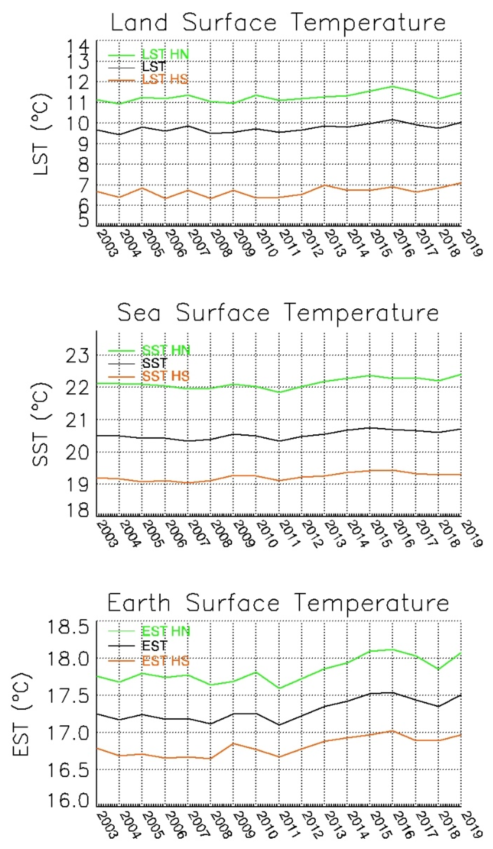
The annual values of LST, SST and EST are presented in
Figure 2 for the period 2003–2019 by hemisphere and globally. Stability in surface temperatures prevails, as in [
1], until 2011, when the temperature begins to rise, reaching a maximum in 2015 for SST (20.75 °C) and in 2016 for LST (10.18 °C) and EST (17.54 °C). This is followed by a gradual decrease until 2018 followed by an increase in 2019. The temperature variations 2011–2019 suppose, in absolute terms, an increase for SST, LST and EST of 0.38, 0.48 and 0.41 °C, respectively. The variations of NOAA NCDC global (EST) anomalies during 2011–2019 is 0.38 °C. Finally, how the values obtained in the NH are higher than those of the SH is also shown. Thus, the average of the last 17 years shows that the LST, SST and EST are 4.6 °C, 2.9 °C and 1.0 °C higher in NH than in SH.
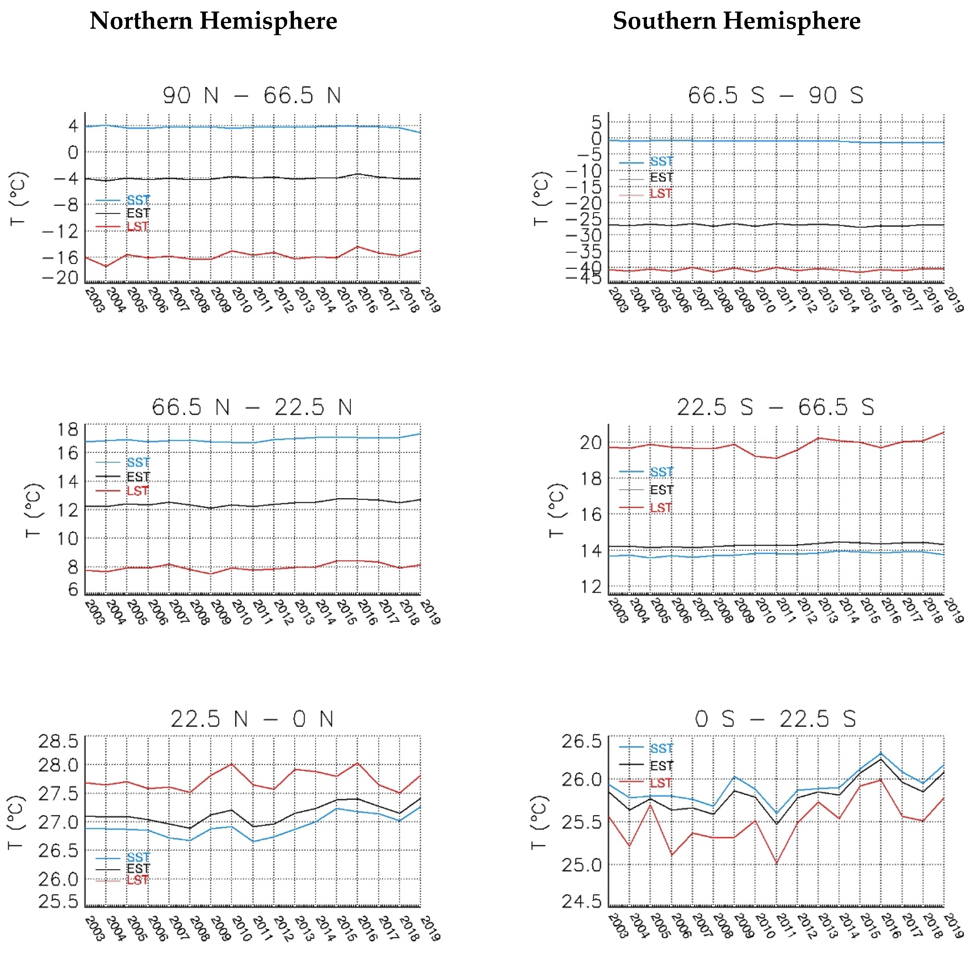
In
Figure 3, SST, LST and EST are shown for the six latitudinal zones considered. The results are very similar to those observed in [
1], with the inclusion of years 2017, 2018 and 2019. In general, the curves show a decrease in temperature from 2016 to 2018 followed by an increase in 2019. Thus, SST curves show a smoother behavior than LST curves. Sea surface is significantly higher than land surface at low and mid latitudes in NH and at low latitudes in the SH, therefore the final EST curve is closer to SST than to LST.
In
Table 1, linear trends in LST, SST and EST were estimated for the period 2003–2019 at global, hemispheric and latitudinal levels. For LST, the highest and lowest values are obtained for the highest and lowest latitudes in NH, while for SST and EST they are obtained for the mid latitudes in the NH and the highest in the SH, respectively. It is also observed that the trends are higher in the NH than in the SH for all cases and for the global trends of LST, SST and EST are obtained increases of 0.027, 0.019 and 0.021 °C per year respectively.
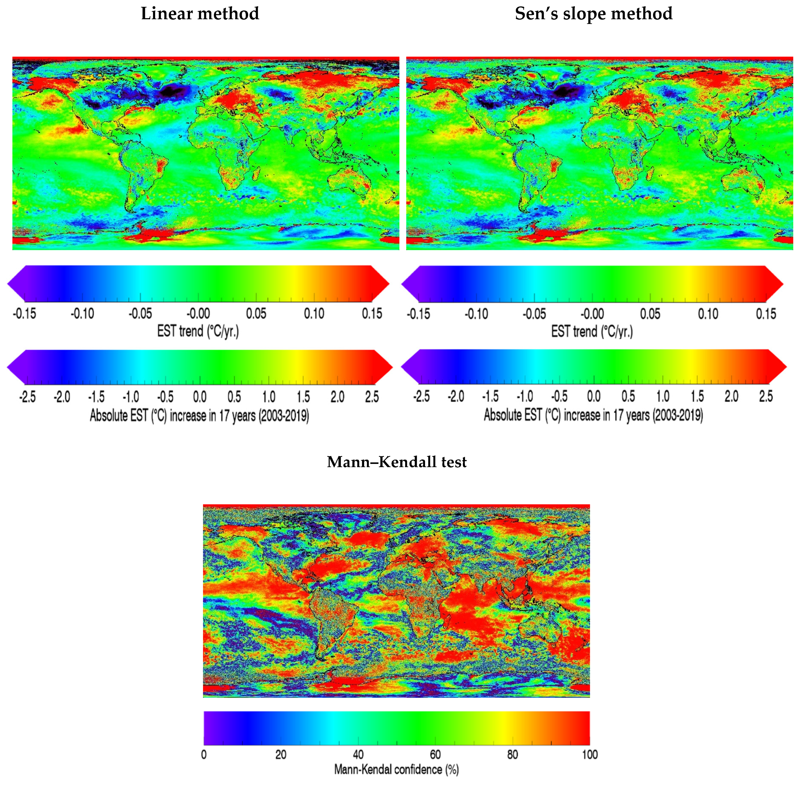
Finally,
Figure 4 shows the global trend maps estimated by both linear and Sen’s slope methods, for the period 2003–2019. A large area on the North Atlantic next to Greenland displays a decreasing SST. However, the remaining areas show an increase in their SST compared to the results derived from [
1] with a Mann–Kendal level significance of 99.7%. Particularly significant are the areas in red that imply temperature increases greater than 2 degrees, over the 17-year period analyzed.
4. Conclusions
This is an update of Sobrino et al.’s paper [
1], which extends the calculation of the Earth’s surface temperature to the period 2003–2019 and uses the new version 2019.0 for the sea surface temperature product MODIS, which is available from 15 January 2020 and replaces version 2014.0. The results corroborate and improve those obtained in Sobrino et al.’s paper [
1], thus the comparison between the Earth Surface Temperature presented in this work and the NOAA-NCDC air temperature data show a correlation coefficient of 0.96, 0.93 in Sobrino et al.’s paper [
1], demonstrating the high potential of thermal infrared satellite data to provide accurate data for climatic and meteorological studies.
The global EST trend obtained for the period 2003–2019 is 0.021 °C/yr, which is very similar to 0.022 °C/yr provided by the NOAA-NCDC air temperature dataset. Global results from both datasets show a temperature decrease from 2016 to 2018, with an increase in the year 2019. EST trends are similar in the NH (0.023 °C/yr) and in the SH (0.019 °C/yr). Differences are more remarkable with latitude, thus, in the case of SST, negative trends are observed in the high latitudes of both hemispheres, while in the rest of the areas, the trend is positive. As for the LST, a positive trend of 0.071 °C (2.6 times the global trend of the SST) is obtained in the high latitudes of the NH. Finally, EST only shows a negative trend of −0.014 °C/year in the high latitudes of SH and positive in the rest of the areas.
In summary, this paper demonstrates that global temperature trends obtained from air temperature data can be replicated with surface temperature obtained from satellite data. Seventeen years of data were analysed and new data will be added in the future as they become available in order to monitor the temperature of our planet from satellites.
Author Contributions
Authors contributions are detailed: conceptualization, J.A.S.; methodology, J.A.S., Y.J. and S.G.-M.; software, Y.J. and S.G.-M.; validation, J.A.S., S.G.-M. and Y.J.; formal analysis, J.A.S., S.G.-M. and Y.J.; investigation, J.A.S., Y.J. and S.G.-M.; resources, J.A.S.; data curation, Y.J. and S.G.-M.; writing—original draft, J.A.S., Y.J. and S.G.-M.; writing—review and editing, J.A.S.; visualization, S.G.-M.; supervision, J.A.S. and Y.J.; project administration, J.A.S.; funding acquisition, J.A.S. All authors have read and agreed to the published version of the manuscript.
Funding
This research was funded by Ministerio de Ciencia, Innovación y Universidades project ESP2017-85770-R and grant number FPU18/01239.
Acknowledgments
The authors thank the NASA Land Processes Distributed Active Archive Center and Physical Oceanography Distributed Active Archive Center and the NOAA teams for making data freely available.
Conflicts of Interest
The authors declare no conflict of interest. The funders had no role in the design of the study; in the collection, analyses, or interpretation of data; in the writing of the manuscript, or in the decision to publish the results.
References
- Sobrino, J.A.; Julien, Y.; García-Monteiro, S. Surface Temperature of the Planet Earth from Satellite Data. Remote Sens. 2020, 12, 218. [Google Scholar] [CrossRef]
- Physical Oceanography Distributed Active Archive Center (PO.DAAC). Firefox ESR v38.4.0. Web Page; NASA EOSDIS PO.DAAC: Pasadena, CA, USA, 2018. Available online: https://podaac.jpl.nasa.gov/ (accessed on 17 January 2020).
- Land Processes Distributed Active Archive Center (LP DAAC). NASA EOSDIC LP.DAAC: Sioux Falls, South Dakota, 2018. Available online: https://lpdaac.isgs.gov/ (accessed on 17 January 2020).
- Wan, Z. New refinements and validation of the collection-6 MODIS land-surface temperature/emissivity product. Remote Sens. Environ. 2014, 140, 36–45. [Google Scholar] [CrossRef]
- Brown, O.B.; Minnett, P.J. MODIS Infrared Sea Surface Temperature Algorithm Theoretical Basis Document, Ver 2.0. 1999. Available online: http://modis.gsfc.nasa.gov/data/atbd/atbd_mod25.pdf (accessed on 25 January 2020).
- NOAA National Centers for Environmental Information. State of the Climate: Global Climate Report for Annual 2018. Available online: https://www.ncdc.noaa.gov/sotc/global/201913 (accessed on 20 February 2020).
© 2020 by the authors. Licensee MDPI, Basel, Switzerland. This article is an open access article distributed under the terms and conditions of the Creative Commons Attribution (CC BY) license (http://creativecommons.org/licenses/by/4.0/).


