


Land 2026, 15(5), 836; https://doi.org/10.3390/land15050836 (registering DOI) - 14 May 2026
Abstract
Subsidence is the lowering of the ground surface caused by both natural processes, such as geological and tectonic dynamics, and anthropogenic activities related to land and resource use. Identifying and monitoring this phenomenon is essential for several reasons, including ensuring public safety, supporting
[...] Read more.
Subsidence is the lowering of the ground surface caused by both natural processes, such as geological and tectonic dynamics, and anthropogenic activities related to land and resource use. Identifying and monitoring this phenomenon is essential for several reasons, including ensuring public safety, supporting the sustainable management of subsurface resources, and mitigating potential economic impacts. This study investigates ground deformation in an underexplored sector of the Calabria Region (Southern Italy), namely the Sant’Eufemia Plain. To this end, long-term Sentinel-1 datasets were processed using multi-temporal Synthetic Aperture Radar Interferometry techniques. Significant subsidence, reaching locally up to −17 mm/yr, was detected in the industrial area of San Pietro Lametino. Historical SAR datasets (ERS, ENVISAT) and optical imagery were used to reconstruct the long-term evolution of deformation since the 1990s. Satellite observations were integrated with rainfall records, piezometric data, and geotechnical modelling. A spatially distributed comparison between groundwater level variations and InSAR-derived deformation, supported by local time-series analysis, highlights weak and inconsistent correlations, indicating that groundwater fluctuations alone do not linearly control subsidence. The results suggest that subsidence is primarily associated with long-term consolidation processes affecting highly compressible Holocene deposits, likely enhanced by anthropogenic loading, while groundwater variations may contribute by modifying effective stress conditions within the subsoil. The relative contribution of these processes remains unquantified, highlighting the need for coupled hydro-mechanical investigations.
Full article
(This article belongs to the Special Issue Digital Earth and Remote Sensing for Land Management, 2nd Edition)
►
Show Figures
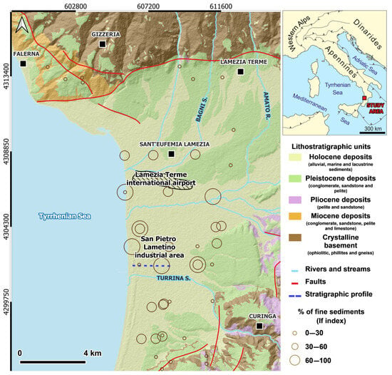
Figure 1


