
Skip to Content
You are currently on the new version of our website. Access the old version .
  • 2.5
    Impact Factor
  • 2.6
    CiteScore
  • 28 days
    Submission to First Decision
  • 8 days
    Acceptance to Publication

Oceans

Oceans is an international, peer-reviewed, open access journal of oceanography, published bimonthly online by MDPI.

Get Alerted

Add your email address to receive forthcoming issues of this journal.

All Articles (371)

  • Article
  • Open Access

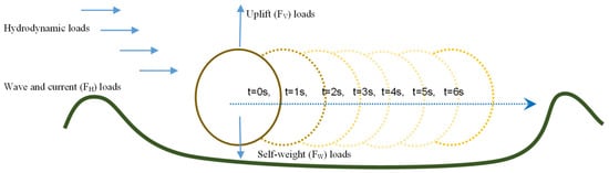
The interactions between subsea pipelines and the seabed generate complex vibratory responses that can compromise structural integrity, yet these interactions remain difficult to characterize with sufficient fidelity for design purposes. This study examines a numerical workflow for incorporating hydrodynamic forces and displacement-dependent pipe-soil interaction into the finite element analysis of a nominally 400 m subsea pipeline. The hydrodynamic formulation includes irregular wave kinematics, directional spreading, current effects, and force corrections related to pipeline movement, while the geotechnical representation uses prescribed pipe-soil contact and lateral resistance relationships. The workflow links local resistance characterization with the global structural response and investigates the sensitivity of calculated lateral displacement to applied stabilization weight and seabed strength assumptions. This approach enables computationally efficient structural analysis without sacrificing the fidelity needed to assess whole-system performance, directly addressing the central modeling challenge posed by the pipe-soil interface. Over a 100-year simulated service life, the maximum lateral displacement recorded across the 400 m pipeline reached 5.43 m, while displacement peaked at approximately 3.98 m under a chain weight of 18.37 kg. These results demonstrate the model’s sensitivity to key design parameters governing pipeline stability. The analysis provides an implementation-based case study for assessing the consequences of alternative seabed-resistance assumptions rather than establishing a new soil constitutive model or an independently validated through-life design procedure, and it provides a robust foundation for future subsea pipeline engineering practices.

Oceans

10 November 2026

Schematic of pipe loading and potential displacement response.
  • Review
  • Open Access

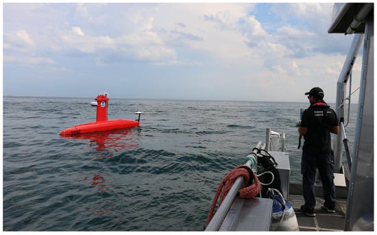
Unmanned surface vehicles (USVs) have emerged as a new type of marine carrier platform and are attracting increasing attention in marine geological surveying owing to their flexibility, low observability and unmanned operation. This review systematically traces the development history and current status of USVs worldwide and in China and summarizes the state of the art of USV-based marine geological survey technology from three perspectives: autonomous control, sensor integration, and data transmission and processing. Two representative applications, seafloor topographic and geomorphological surveying and sub-seafloor geophysical exploration, are examined to illustrate engineering practice. Recent advances and technological trends are then outlined in terms of cross-domain collaborative operations, upgrading of core equipment, expansion of application scenarios and standardization. Remaining challenges are analyzed, including limited adaptability to complex environments, insufficient autonomous decision-making, data quality control and the low domestic production rate of core components, and future development directions are proposed. With continued technological progress, deeper research and improvement of the relevant survey standards, USVs are expected to mature into a stand-alone technical means for marine geological surveying.

Oceans

9 November 2026

DriX USVs operated from the shore-based remote operations center at the Center for Coastal and Ocean Mapping, University of New Hampshire, during the NOAA “Dual DriX” project in the Gulf of Maine, October 2024 (source: NOAA, public domain; also cited as Ref. [24]).
  • Article
  • Open Access

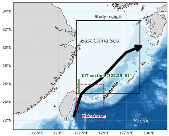
The Pacific Decadal Oscillation (PDO) is the leading mode of North Pacific sea-surface temperature variability and exerts a profound influence on marine fisheries. Focusing on Larimichthys polyactis in the East China Sea (ECS), our analysis reveals a lagged effect of the PDO on the Larimichthys polyactis catch. The PDO–catch relationship for Larimichthys polyactis in the ECS is associated with three environmental factors: kuroshio intrusion transport (KIT), chlorophyll a (Chl a), and subsurface water temperature. These findings provide a scientific basis for integrating climate information into fisheries forecasting and adaptive management for the ECS.

Oceans

4 November 2026

Map of the study area, the ECS (25–33° N, 122–129° E). The black curved arrow denotes the Kuroshio. Two Kuroshio transport indices are marked: the surface mainstream speed index, defined as the maximum surface current speed over 23–26° N, 122–125° E (red dashed box), representing the intensity of the Kuroshio mainstream; and the Kuroshio intrusion transport (KIT), defined as the eastward volume transport over 0–200 m across the 122.25° E section between 25 and 26.5° N (green solid line), representing the intensity of Kuroshio intrusion onto the ECS shelf.
  • Article
  • Open Access

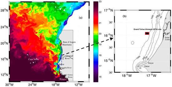
Recent offshore hydrocarbon discoveries along the Senegalese–Mauritanian margin increase the need to quantify oil-spill risk under the highly dynamic circulation of the southern Canary Current upwelling system. We investigate seasonal pollutant dispersion along the Senegalese Grande Côte using Lagrangian particle-tracking experiments forced by outputs from the open-source hydrodynamical ocean model CROCO. The analysis focuses on the role of wind-driven circulation, Ekman transport, and upwelling variability in controlling cross-shore and alongshore transport pathways. Results show a strong seasonal coastal circulation variability. During the cold season (January–May), intensified northerly winds drive coastal upwelling and offshore Ekman transport, enhancing divergence of surface currents and promoting the export of particles away from the coast. This regime limits particle nearshore accumulation but favors broader offshore dispersion over the continental shelf. In contrast, during the warm season (June–September), weakened upwelling-favorable winds and the establishment of anticyclonic circulation north of the Cape induce onshore transport and coastal retention. Particle-release experiments reveal enhanced trapping and accumulation along the Grande Côte during this period. The Kayar region and the Cape Verde Peninsula exhibit relatively higher pollutant exposure during the cold season, whereas the inner continental shelf along the Grande Côte becomes particularly vulnerable during the warm season. These findings suggest that seasonal wind forcing and associated Ekman dynamics have a significant influence on the trajectories of oil spills. Incorporating this variability into contingency planning is essential, as the inner continental shelf of the Senegalese Grande Côte is a dynamically sensitive, high-exposure zone under the warm-season circulation regime.

Oceans

28 October 2026

Instantaneous SST (°C) field from CROCO (a) for the core of the upwelling season (2 April 2002) and (b) the study area (Grande Côte of Senegal). Isobaths 50, 100, 200, and 1000 m are also shown. The black box with red contour represents the Grand Tortue Ahmeyim (GTA) offshore oil and gas platform location.

Featured Articles of Last Quarter

Highly Accessed Articles

News & Conferences

Latest Issues

Open for Submission

Journal Sections

XFacebookLinkedIn
Oceans - ISSN 2673-1924