


Coasts 2026, 6(2), 21; https://doi.org/10.3390/coasts6020021 - 19 May 2026
Abstract
►
Show Figures
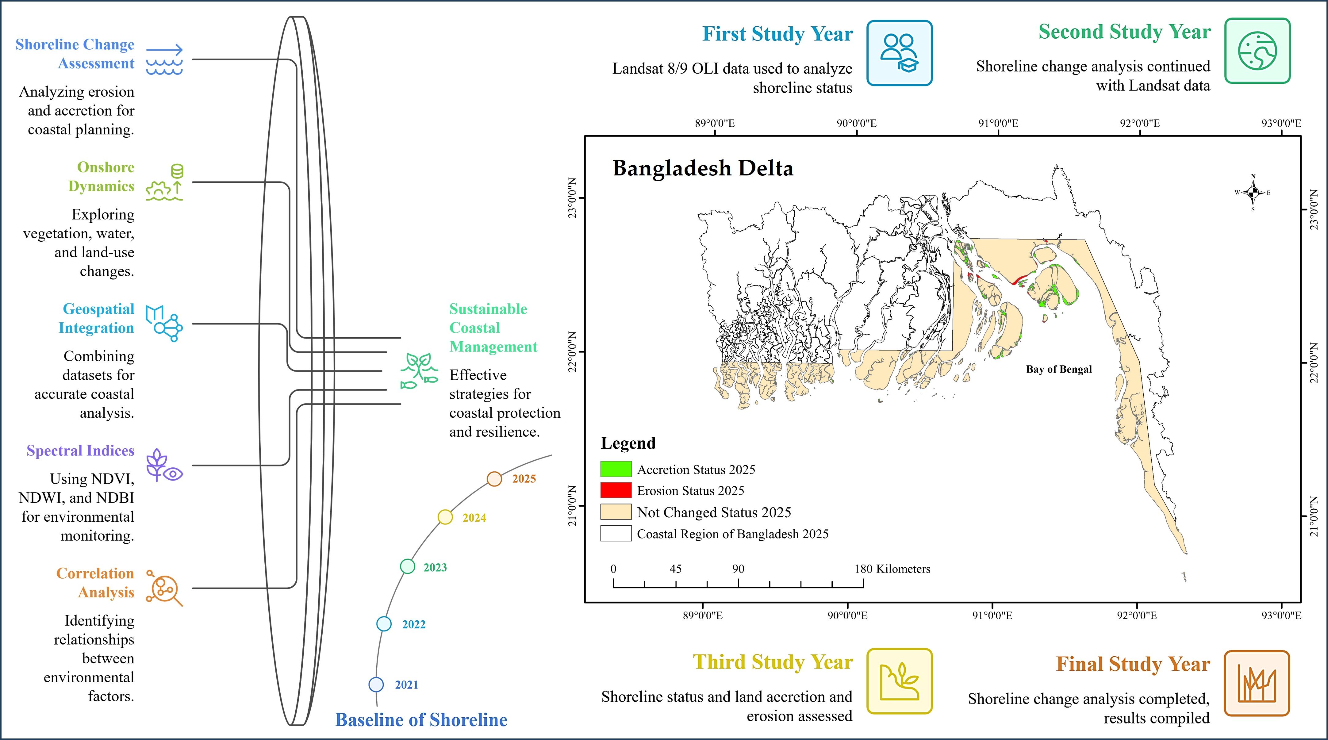
Bangladesh is an extremely climate-exposed country, with erosion, accretion, tidal surges, and cyclones continuously modifying coastal districts. Shoreline change in Bangladesh is crucial for sustainable coastal management and disaster resilience. Therefore, the objectives of this research are as follows: (i) to assess accretion-
[...] Read more.
Bangladesh is an extremely climate-exposed country, with erosion, accretion, tidal surges, and cyclones continuously modifying coastal districts. Shoreline change in Bangladesh is crucial for sustainable coastal management and disaster resilience. Therefore, the objectives of this research are as follows: (i) to assess accretion- and erosion-based shoreline changes of the Bangladesh delta adjacent to the Bay of Bengal for 2021–2025 using a fixed 2021 reference shoreline and a 2025 shoreline proxy extracted from Landsat 8/9 imagery, and (ii) to explore onshore change dynamics from satellite-derived NDVI, NDBI, and NDWI for 2022–2025. The study covers 14 coastal districts and integrates the 2021 baseline shoreline, Survey of Bangladesh geospatial datasets, and 17,055 Ground Reference Points (GRPs) to support geometric consistency and spatially explicit reporting at the delta scale. Three spectral indices—Normalized Difference Vegetation Index (NDVI), Normalized Difference Water Index (NDWI), and Normalized Difference Built-up Index (NDBI)—were applied to assess vegetation health, surface water distribution, and built-up/exposed land characteristics. Results indicate spatial variability in coastal change, with 383.49 km2 of land gained through accretion and 124.12 km2 lost to erosion, resulting in a neat accretion of 259.37 km2 between 2021 and 2025; 8747.91 km2 remained geomorphologically stable. Spectral index trends show minimal inter-annual NDVI and NDWI variability, suggesting stable vegetation cover and no long-term expansion of surface water. In contrast, a slight increase in NDBI indicates localized exposure of new sediments or small-scale land-use transitions along emerging coastal zones. Spearman correlation analysis highlights consistent negative relationships between NDVI and NDWI and moderate contrasts between NDVI and NDBI, reinforcing the coexistence of vegetation recovery, water withdrawal, and sediment-driven land emergence. The novelty of this study lies in the provision of consistent, near-real-time coastal change inventory for the full ~710 km Bangladesh delta coastline by combining a common 2021 baseline shoreline with harmonized Landsat 8/9 OLI surface reflectance (2022–2025) and linked onshore spectral-index dynamics over the same period. Overall, this short-term assessment reveals a sedimentary system that is active but balanced, with accretion surpassing erosion despite cyclone-affected disturbances, underscoring the value of operational satellite monitoring for coastal management, hazard preparedness, and climate-adaptive planning.
Full article
Graphical abstract


