

Journal Menu
► ▼ Journal Menu-
- Remote Sensing Home
- Aims & Scope
- Editorial Board
- Reviewer Board
- Topical Advisory Panel
- Photography Exhibition
- Instructions for Authors
- Special Issues
- Topics
- Sections & Collections
- Article Processing Charge
- Indexing & Archiving
- Editor’s Choice Articles
- Most Cited & Viewed
- Journal Statistics
- Journal History
- Journal Awards
- Society Collaborations
- Conferences
- Editorial Office
Journal Browser
► ▼ Journal BrowserNeed Help?
Announcements
7 November 2017
MDPI has signed the Jussieu Call for Open Science and Bibliodiversity
The Jussieu Call aims to develop and implement alternative models to meet the aims of open science while promoting bibliodiversity. In particular it wishes to promote new business models for funding open access publication. It was drafted on the Jussieu campus in Paris by a group of French researchers and scientific publishing professionals.
MDPI supports scholarly communities and initiatives that innovate and further promote Open Access publishing. There is a need to explore different frameworks to fund open access in ways that ensure that excessive funds are not diverted from research towards publishing. Many fair funding models already exist, and they can be further developed and extended. These include institutional support, library contributions or subsidies, premium services, participatory funding, etc. For this reason, MDPI has signed up to the Jussieu call and welcomes its aims.
More information can be found at http://jussieucall.org/ (archived here)

6 October 2017
Dr. Franck Vazquez, MDPI CEO, Interviewed by Scholarly Kitchen
The Society for Scholarly Publishing’s popular blog about topics in academic publishing, Scholarly Kitchen, recently interviewed MDPI’s CEO, Dr. Franck Vazquez. He shared some thoughts and information on the past and future of MDPI and open access publishing in general:
“In the long run, we aim to anchor MDPI in research communities. We recently developed and launched the preprint platform Preprints, revamped our free-to-use conference hosting platform Sciforum, and are working on other projects, such as Scilit, our bibliographic database.”
Read the full interview here.
27 September 2017
Meet Us at Pecora 20: 13–16 September 2017, Sioux Falls, South Dakota, USA
Members of the ISPRS International Journal of Geo-Information and Remote Sensing editorial teams will be attending Pecora 20, in Sioux Falls, South Dakota, USA (http://pecora.asprs.org/). The theme of Pecora 20 is “Observing a Changing Earth: Science for Decisions…Monitoring, Assessment, and Projection.” This conference will offer a session on applications of satellites and other Earth observations to monitor, assess, and perform projections of future land and water resources, as well as big data and other analytical technologies to improve decision making utilizing satellite data
Please come along to our booth (B21) to chat with our delegates about online publishing and any specific questions you may have regarding our journals. We look forward to meeting you in person!
For more information on the Pecora 20, please visit:
http://pecora.asprs.org/ and for information on our journals:
ISPRS International Journal of Geo-Information (https://www.mdpi.com/journal/ijgi)
Remote Sensing (https://www.mdpi.com/journal/remotesensing)
19 September 2017
A Warm Welcome to the New IOAP Participants
We are delighted to have welcomed 24 new participants to our Institutional Open Access Programme (IOAP) since the beginning of September this year. These are University libraries and Research Institutions located around the world; from the USA and Canada to the UK, and from Norway and Spain to Greece. Well respected Universities, such as the University of Denver, the University of Colorado Boulder, and the University of Arizona in the US, have signed up, while their researchers can now benefit from a 10% discount on the Article Processing Charges (APC) for any papers they publish in MDPI journals, at no cost for the library or the University.
We are more than happy to see the Open Access movement growing stronger and wider every day and we appreciate the vital role which librarians, repository managers, and other scholarly communications professionals play in the field. Our communication with and service to this community is, therefore, one of our principal priorities. The IOAP is our way to support academic and scientific Institutions as well as their scholars in managing, administrating, and publishing research in an Open Access world.
The IOAP set of free services, provided by MDPI to institutions that sign up, include:
- No fee for participants and no obligation to prolong after the initial 12 months. The participants may withdraw from the programme at any time, and we will also keep it free for the library for as long as they continue in the programme.
- Authors affiliated with the university will receive a discount on the article processing charge (APC).
- The institution is granted free access to the MDPI submission system and can receive free alerts of new submissions to our journals.
- By default, authors from the institution will continue to be invoiced directly unless the institution opts for central billing.
- Auto-archiving of papers into the institutions´ repository as long as it supports SWORD 1.3.
More details about the programme and a list of our current participant institutions can be found at: https://www.mdpi.com/about/ioap
Institutions which are interested to participate may do so online at: https://www.mdpi.com/ioap-form
The full list of the Institutions that signed up in September is as follows:
- University of Denver, USA
- University of Colorado Boulder, USA
- University of Arizona, USA
- Institute of Metrology of Bosnia and Herzegovina, Bosnia and Herzegovina
- Middlebury College, USA
- Touro College, USA
- University of New Orleans, USA
- University of Leicester, UK
- Indiana University-Purdue University Indianapolis, USA
- University of Strathclyde, UK
- Cranfield University, UK
- Hope College, USA
- Oregon State University, USA
- Drew University, USA
- Swansea University, UK
- University of South Florida, USA
- University of Georgia, USA
- Arizona State University, USA
- University of Southern Mississippi, USA
- Université du Québec à Chicoutimi, Canada
- Grinnell College, USA
- Norwegian University of Science and Technology, Norway
- University of Patras, Greece
- Public University of Navarre, Spain
23 June 2017
Congratulations for Publishing the 100,000th Peer-Reviewed Article
Congratulations to the authors Javier Monroy and Javier Gonzalez-Jimenez from Universidad de Malaga, Spain, Victor Hernandez-Bennets, Han Fan and Achim Lilienthal from Örebro University, Sweden for publishing the 100,000th peer-reviewed article.
The article is published in the Chemical Sensors section of Sensors.
GADEN: A 3D Gas Dispersion Simulator for Mobile Robot Olfaction in Realistic Environments
Evermore pressing environmental concerns have led global actors and decision-makers to search for stricter emission monitoring approaches. As part of novel monitoring systems, robots with gas and environmental sensors are a promising solution. However, validation of such robotic inspectors is expensive, time consuming, and plagued by repeatability issues. In this article, we present GADEN (the short form for Gas Dispersion Simulator for Mobile Robot Olfaction in Realistic Environments), which combines gas dispersion and robotics simulation in a common framework. Developed under the widely used Robot Operating System (ROS), GADEN enables validation of sensing strategies with gas dispersion being simulated using computational fluid dynamics and filament dispersion theory. GADEN allows simulating complex, realistic, 3D environments for reproducible testing of robotic gas sensing algorithms. Through qualitative and quantitative evaluations, we show that GADEN is a versatile and user-friendly evaluation tool and emphasize its enormous potential for the mobile robot olfaction community.
Read the full article here: https://www.mdpi.com/1424-8220/17/7/1479/htm
14 June 2017
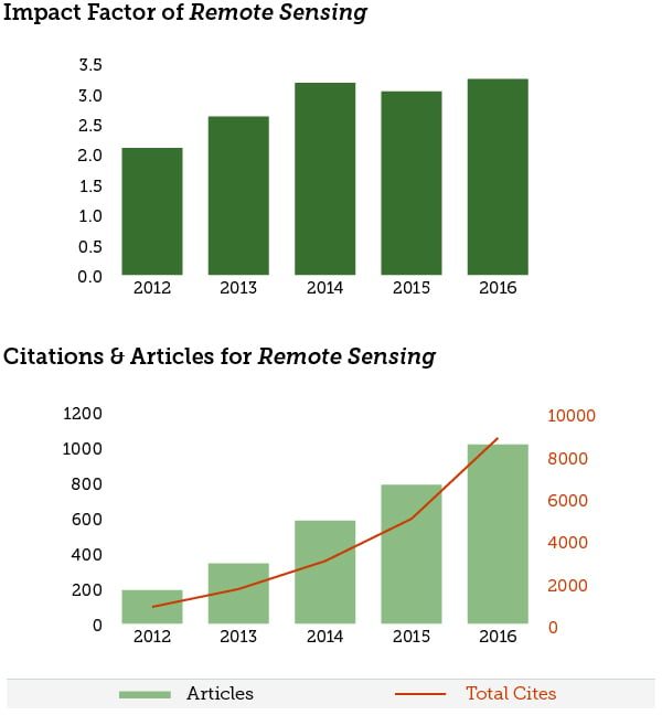
2016 Impact Factor Released for Remote Sensing – 3.244
Remote Sensing now ranks 7/29 (Q1) in the ‘Remote Sensing’ category. It is the highest ranking Open Access journal in this field.
Evolution of Impact Factor, Citations and Publications for Remote Sensing:
6 June 2017
CiteScore™ Metrics Released for Scopus Journals
The CiteScore, the new citation metric for journals covered in the Scopus® database, was released on 1 June 2017, reflecting the citation activity in 2016 for articles published during the three previous years. Please note that the list below does not contain all MDPI journals covered in Scopus. For the CiteScore to serve as a reliable metric at least three volumes of articles need to be indexed in Scopus; journals which have not met this criterion have been omitted here.
Ten MDPI journals received a CiteScore which is in the Top 10% of scores in at least one of the categories, while a further 21 journals exhibit scores that are in the first quartile of the respective categories.
CiteScore Data for MDPI Journals
| Journal | Rank | Category | Link | CiteScore 2016 | 2015 |
2014 |
| Algorithms | 44/112 (Q2) 49/111 (Q2) 19/42 (Q2) 52/113 (Q2) |
• Numerical Analysis • Computational Mathematics • Computational Theory and Mathematics • Theoretical Computer Science |
Link | 1.15 | 1.07 | 1.06 |
| Animals | 69/343 (Q1) 21/146 (Q1) |
• Animal Science and Zoology • General Veterinary |
Link | 1.46 | 1.66 | 0.74 |
| Biology | 13/92 (Q1) 34/81 (Q1) 10/75 (Q1) |
• General Agricultural and Biological Sciences • General Biochemistry, Gene- tics and Molecular Biology • General Immunology and Microbiology |
Link | 3.02 | 2.78 | 1.74 |
| Biomolecules | 234/382 (Q3) 260/353 (Q3) |
• Biochemistry • Molecular Biology |
Link | 1.67 | 3.08 | 1.00 |
| Biosensors | 36/118 (Q2) 209/2156 (Q1) |
• Clinical Biochemistry • General Medicine |
Link | 2.83 | 2.37 | 2.04 |
| Cancers | 29/196 (Q1) 27/321 (Q1) |
• Cancer Research • Oncology |
Link | 5.02 | 4.07 | 2.31 |
| Catalysts | 18/44 (Q2) 27/144 (Q1) |
• Catalysis • Physical and Theoretical Chemistry |
Link | 3.44 | 3.45 | 2.17 |
| Crystals | 70/270 (Q2) 25/64 (Q2) 118/398 (Q2) 131/424 (Q2) |
• General Chemical Engineering • Inorganic Chemistry • Condensed Matter Physics • General Materials Science |
Link | 1.89 | 1.47 | 1.03 |
| Diversity | 10/41 (Q1) 9/25 (Q2) 76/291 (Q2) 24/109 (Q1) |
• Agricultural and Biological Sciences (miscellaneous) • Ecological Modelling • Ecology • Nature and Landscape Conservation |
Link | 2.03 | 1.96 | 1.82 |
| Energies | - | - | Link | 2.50 | 2.87 | 2.66 |
| Entropy | 51/198 (Q2) | • General Physics and Astronomy | Link | 1.87 | 1.99 | 1.69 |
| Forests | 17/127 (Q1) | • Forestry | Link | 2.06 | 1.76 | 1.84 |
| Games | 204/398 (Q3) 83/181 (Q2) 48/105 (Q2) |
• Applied Mathematics • Statistics and Probability • Statistics, Probability and Uncertainty |
Link | 0.87 | 0.57 | 0.64 |
| Genes | 62/300 (Q1) 18/90 (Q1) |
• Genetics • Genetics (clinical) |
Link | 3.62 | 3.18 | 1.33 |
| Geosciences | 36/169 (Q1) |
• General Earth and Planetary Sciences | Link | 1.67 | 1.29 | 1.13 |
| Information | 156/237 (Q3) | • Information Systems | Link | 0.78 | 0.94 | 0.74 |
| Insects | 28/131 (Q1) | • Insect Science | Link | 1.81 | 1.38 | 1.23 |
| International Journal of Environmental Research and Public Health (IJERPH) | 67/446 (Q1) 31/102 (Q2) |
• Public Health, Environmental and Occupational Health • Health, Toxicology and Mutagenesis |
Link | 2.38 | 2.42 | 2.47 |
| International Journal of Molecular Sciences (IJMS) | 23/157 (Q1) 8/64 (Q1) 90/353 (Q1) 22/144 (Q1) 16/44 (Q1) 8/62 (Q1) |
• Organic Chemistry • Inorganic Chemistry • Molecular Biology • Physical and Theoretical Chemistry • Catalysis • Spectroscopy |
Link | 3.73 | 3.37 | 3.06 |
| ISPRS International Journal of Geo-Information | 12/29 (Q2) 28/79 (Q2) 96/587 (Q1) |
• Computers in Earth Sciences • Earth and Planetary Sciences (miscellaneous) • Geography, Planning and Development |
Link | 1.62 | 1.52 | - |
| Journal of Low Power Electronic Applications (JLPEA) | 301/645 (Q2) | • Electrical and Electronic Engineering | Link | 0.98 | 0.83 | 0.83 |
| Life | 65/525 (Q1) 36/186 (Q1) 5/92 (Q1) 20/80 (Q2) |
• Ecology, Evolution, Behavior and Systematics • General Biochemistry, Gene- tics and Molecular Biology • Palaeontology • Space and Planetary Science |
Link | 2.95 | 1.68 | 1.20 |
| Marine Drugs | 18/145 (Q1) | • Drug Discovery | Link | 3.83 | 3.66 | 3.59 |
| Materials | 63/424 (Q1) | • General Materials Science | Link | 3.26 | 3.11 | 2.69 |
| Membranes | 103/424 (Q1) | • Materials Science | Link | 2.19 | 2.95 | 2.42 |
| Micromachines | 173/645 (Q2) 69/211 (Q2) 113/526 (Q1) |
• Electrical and Electronic Engineering • Control and Systems Engineering • Mechanical Engineering |
Link | 1.83 | 1.78 | 2.10 |
| Minerals | 45/206 (Q1) 29/167 (Q1) |
• Geology • Geotechnical Engineering and Engineering Geology |
Link | 2.13 | 1.77 | - |
| Molecules | 32/157 (Q1) | • Organic Chemistry | Link | 3.09 | 2.65 | 2.62 |
| Nutrients | 12/247 (Q1) | • Food Science | Link | 4.29 | 4.07 | 3.78 |
| Pharmaceuticals | 8/168 (Q1) 21/158 (Q1) |
• Pharmaceutical Science • Molecular Medicine |
Link | 4.90 | 3.64 | 1.92 |
| Pharmaceutics | 19/168 (Q1) | • Pharmaceutical Science | Link | 3.83 | 2.68 | 2.46 |
| Polymers | 13/138 (Q1) 44/354 (Q1) |
• Polymers and Plastics • General Chemistry |
Link | 3.74 | 3.37 | 4.10 |
| Remote Sensing | 13/169 (Q1) | • General Earth and Planetary Sciences | Link | 3.56 | 3.76 | 3.23 |
| Sensors | 25/96 (Q2) 25/159 (Q1) 124/382 (Q2) 103/645 (Q1) |
• Analytical Chemistry • Atomic and Molecular Physics, and Optics • Biochemistry • Electrical and Electronic Engineering |
Link | 2.78 | 2.21 | 2.40 |
| Sustainability | 49/129 (Q2) 68/587 (Q1) 56/236 (Q1) |
• Renewable Energy, Sustai-nability and the Environment • Geography, Planning and Development • Management, Monitoring, Policy and Law |
Link | 1.96 | 1.78 | 1.52 |
| Symmetry | 17/42 (Q2) 49/111 (Q2) |
• Numerical Analysis • Computational Mathematics |
Link | 1.12 | 0.95 | 1.02 |
| Toxins | 16/102 (Q1) 16/108 (Q1) |
• Health, Toxicology and Mutagenesis • Toxicology |
Link | 3.34 | 3.76 | 2.85 |
| Vaccines | 146/184 (Q4) 151/250 (Q3) 93/145 (Q3) 186/299 (Q3) 130/232 (Q3) |
• Immunology • Infectious Diseases • Drug Discovery • Pharmacology • Pharmacology (medical) |
Link | 1.23 | 3.76 | 2.85 |
| Viruses | 15/68 (Q1) 34/250 (Q1) |
• Virology • Infectious Diseases |
Link | 3.60 | 3.74 | 3.80 |
| Water | 33/184 (Q1) 48/195 (Q1) 62/587 (Q1) 198/382 (Q3) |
• Water Science and Technology • Aquatic Science • Geography, Planning and Development • Biochemistry |
Link | 2.05 | 1.96 | 1.45 |
17 May 2017
Three New Institutional Memberships Established
![]()
We are pleased to announce that the Goethe University of Frankfurt, the Technical University of Hamburg (TU Hamburg-Harburg), as well as the Humboldt University of Berlin, in Germany, have joined MDPI's institutional membership program: Primary authors from these instititions will benefit from a 10% discount on the article processing charges.
Additional details can be found on our institutional membership page.


4 May 2017
MDPI Supports the Initiative for Open Citations (I4OC)
As an open access publisher, we are keen to support openness and transparency in the research process. Citation data is very important for assessing the value of individual papers and the contribution of researchers. As such, we support the recently launched Initiative for Open Citations (I4OC). The initiative recognizes that citations should be freely available and machine-readable. By doing so, authors gain the maximum benefit from having their work cited.
MDPI now uploads citation data with metadata uploaded to Crossref when registering digital object identifiers (DOIs) for published papers. We are delighted to take this step to support a truly open research environment.
2 May 2017
Publons Peer Review Academy Goes Live
Getting high quality review reports is critical for any journal’s editorial process. At MDPI we have put in place several measures to motivate reviewers and reward them for their work. We are proud of the quality of reviewer reports we receive and grateful for the hours put in by active researchers from across the globe.
Reviewers of MDPI’s largest journals can get recognition via Publons, a website dedicated to rewarding peer reviewers. They have now taken this one step further and launched the Publons Reviewer Academy to help train reviewers to provide useful feedback. Through the academy, researchers can be trained and tutored in various aspects of how to provide structured feedback that will be of genuine help to editors and authors. We support this initiative and recommend it to potential MDPI reviewers, especially early career researchers. See the Publons announcement for further information.
More information on reviewing for MDPI, including how to volunteer as a reviewer, can be found here.