Journal Description
Geosciences
Geosciences
is an interdisciplinary, international peer-reviewed open access journal of geoscience, future earth and planetary science published monthly online by MDPI. The European Federation of Geologists (EFG) is affiliated with Geosciences, and its members receive a discount on the article processing charge.
- Open Access— free for readers, with article processing charges (APC) paid by authors or their institutions.
- High Visibility: indexed within Scopus, ESCI (Web of Science), GeoRef, Astrophysics Data System, and other databases.
- Journal Rank: CiteScore - Q1 (General Earth and Planetary Sciences)
- Rapid Publication: manuscripts are peer-reviewed and a first decision is provided to authors approximately 22.5 days after submission; acceptance to publication is undertaken in 3.6 days (median values for papers published in this journal in the second half of 2022).
- Recognition of Reviewers: reviewers who provide timely, thorough peer-review reports receive vouchers entitling them to a discount on the APC of their next publication in any MDPI journal, in appreciation of the work done.
Latest Articles
Berriasian–Valanginian Geochronology and Carbon-Isotope Stratigraphy of the Yellow Cat Member, Cedar Mountain Formation, Eastern Utah, USA
Geosciences 2023, 13(2), 32; https://doi.org/10.3390/geosciences13020032 (registering DOI) - 26 Jan 2023
Abstract
The Early Cretaceous Yellow Cat Member of the terrestrial Cedar Mountain Formation in Utah, USA. has been interpreted as a “time-rich” unit because of its dinosaur fossils, prominent paleosols, and the results of preliminary chemostratigraphic and geochronologic studies. Herein, we refine prior interpretations
[...] Read more.
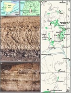
The Early Cretaceous Yellow Cat Member of the terrestrial Cedar Mountain Formation in Utah, USA. has been interpreted as a “time-rich” unit because of its dinosaur fossils, prominent paleosols, and the results of preliminary chemostratigraphic and geochronologic studies. Herein, we refine prior interpretations with: (1) a new composite C-isotope chemostratigraphic profile from the well-known Utahraptor Ridge dinosaur site, which exhibits δ13C features tentatively interpreted as the Valanginian double-peak carbon isotope excursion (the so-called “Weissert Event”) and some unnamed Berriasian features; and (2) a new cryptotephra zircon eruption age of 135.10 ± 0.30/0.31/0.34 Ma (2σ) derived from the CA-ID-TIMS U-Pb analyses of zircons from a paleosol cryptotephra. Our interpretations of δ13C features on our chemostratigraphic profile, in the context of our new radiometric age, are compatible with at least one prior age model for the “Weissert Event” and the most recent revision of the Cretaceous time scale. Our results also support the interpretation that the Yellow Cat Member records a significant part of Early Cretaceous time.
Full article
(This article belongs to the Special Issue Terrestrial Paleoclimatology and Paleohydrology of the Cretaceous Greenhouse World)
Open AccessArticle
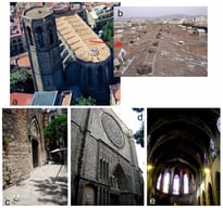
Nature of Paleozoic Basement of the Catalan Coastal Ranges (Spain) and Tectonic Setting of the Priorat DOQ Wine Terroir: Evidence from Volcanic and Sedimentary Rocks
by
, , , , and
Geosciences 2023, 13(2), 31; https://doi.org/10.3390/geosciences13020031 (registering DOI) - 26 Jan 2023
Abstract
The Paleozoic volcano-sedimentary rocks within the structural basement of the horst-and-graben system of the Catalan Coastal Ranges (CCR) are composed of black shale, volcaniclastic sediments, lava flows, sills and lithocrystalloclastic tuffs. Paleozoic sediments are depleted in high-field strength elements (HFSE) such as Nb,
[...] Read more.
The Paleozoic volcano-sedimentary rocks within the structural basement of the horst-and-graben system of the Catalan Coastal Ranges (CCR) are composed of black shale, volcaniclastic sediments, lava flows, sills and lithocrystalloclastic tuffs. Paleozoic sediments are depleted in high-field strength elements (HFSE) such as Nb, Ta, Zr, Hf and Ti, suggesting their accumulation within the Andean-type active continental margin environment. Volcanic rocks within the Paleozoic CCR sequence belong to shoshonitic and high-K volcanic series and are enriched in Cs, Rb and Ba and depleted in HFSE, which is consistent with their derivation from metasomatized (possibly through deep recycling of pelagic sediments) subduction-related mantle source. The presence of sills (sill-sediment complex) suggests that Paleozoic basement of the CCR was formed within the rifted active continental margin or an arc-back-arc basin system akin to the modern Western Pacific subduction configuration. This complex volcanic terroir hosts world-class wines of the Priorat DOQ region. The presence of framboidal pyrite and magnetite, siderite, sphalerite xenotime, (La–Ce–Nd)-monazite, zircon and baddeleyite, as well as cuprite, tenorite and cupriferous and native silver in volcanic-derived black shale (and consequently in the world-famous “llicorella” soil overlying it) may have had dramatic effects on wine quality and sensory characteristics. These mineral features, together with strong enrichment of Priorat shale in Au, Ag and, to a lesser extent, Pt could have pronounced effects on (1) rates and specific types of chemical reactions; (2) plant metabolism; (3) response to nutrient components and (4) determination of grape flavor. Volcanic wine terroirs, such as the Priorat DOQ region, are special geologic environments for wine growth, capable of producing unique wine aromatic and gustatory characteristics.
Full article
(This article belongs to the Special Issue Selected Papers from the 4th International Electronic Conference on Geosciences (IECG 2022))
Open AccessArticle
Slope Dynamics in Relation to the Occupation and Abandonment of a Mountain Farm in Þistilfjörður, Northeast Iceland
Geosciences 2023, 13(2), 30; https://doi.org/10.3390/geosciences13020030 - 25 Jan 2023
Abstract
Extreme weather events such as storms, heavy snow accumulation, rapid snowmelt, and heavy rain have been closely related to slope instability in arctic and subarctic regions. In this paper, we investigate the historical activity of slope processes such as snow avalanches and debris
[...] Read more.
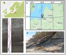
Extreme weather events such as storms, heavy snow accumulation, rapid snowmelt, and heavy rain have been closely related to slope instability in arctic and subarctic regions. In this paper, we investigate the historical activity of slope processes such as snow avalanches and debris flows in Þistilfjörður, northeastern Iceland, and examine their possible role in the occupation and abandonment of three archaeological sites located on slopes of Mt. Flautafell. The study combines geomorphological and stratigraphical surveys with historical records, notably Jarðabók Árna Magnússonar og Páls Vídalíns and Sýslu og sóknarlýsingar Bókmenntafélagsins Svalbarðssókn. Geomorphological surveys show numerous features that are indicative of active slope movement processes in and around the investigated sites. Our results suggest that the slopes experienced periods of instability during the occupation of these sites. The burial or destruction of some parts of the homefield at the Flautafell farm reveals slope activity, which may also be related, at least indirectly, to the abandonment of the farm at Norður Hús sometime before A.D. 1300. Nearby auxiliary farm installations of Stekkur remained untouched by slope processes even though they are situated in a vulnerable area. Further study and dating of slope processes and farm occupation could allow them to be used as proxies for deteriorating environmental conditions affecting the region.
Full article
(This article belongs to the Special Issue Arctic Geoarchaeology and Environmental Archaeology)
Open AccessArticle
UAV Application for Short-Time Evolution Detection of the Vomice Landslide (South Italy)
Geosciences 2023, 13(2), 29; https://doi.org/10.3390/geosciences13020029 - 25 Jan 2023
Abstract
This paper investigates the possibility to detect the short-time evolution of the slow-moving Vomice earth flow, located in the northeastern sector of the Calabria region (South Italy), by combining the information obtained from two different drone flights, carried out in February 2019 and
[...] Read more.
This paper investigates the possibility to detect the short-time evolution of the slow-moving Vomice earth flow, located in the northeastern sector of the Calabria region (South Italy), by combining the information obtained from two different drone flights, carried out in February 2019 and June 2022, with field surveys. The obtained results consisted of delimiting all landslide bodies constituting the Vomice earth flow, detecting landslide types and the state of activity, as well as identifying spatial and volumetric changes. The obtained results showed that depletion and transition zones of the Vomice earth flow are active, while the accumulation zone appears prevalently dormant. Particularly, in the analyzed period, the depletion zone was characterized by local collapses of the main scarps where several slides evolving in earth flows caused more than 20 m of retrogressive fail upslope. The maximum elevation changes observed in these zones were about ±5 m. The volume of the material mobilized by mass movements was about 114.2 × 10³ m3, whereas the volume of the accumulated material was approximately 92.7 × 10³ m3. The transition zone was affected by several slow earthflows that re-mobilized the displaced material located in the middle portion of the landslide and reached the accumulation zone. Overall, the results of this study demonstrated the practicality and feasibility of using UAV tools for detecting the short-time evolution of a large landslide.
Full article
(This article belongs to the Topic Landslide Detection and Monitoring Using Multisource Remote Sensing Data)
Open AccessArticle
Earthquake-Induced Tsunamis in Western Greece (Ionian Sea and Western and Southern Peloponnese): Use of Tsunami Quantities, Impact and ITIS-2012 Intensities for Highlighting Susceptible Areas
Geosciences 2023, 13(2), 28; https://doi.org/10.3390/geosciences13020028 - 25 Jan 2023
Abstract
Taking into account recent studies on the tsunamigenic potential of strike-slip faults, it is concluded that there is a need to reassess their near-source tsunami hazard and risk. One of the areas which needs reassessment is Western Greece, especially the Ionian Islands and
[...] Read more.
Taking into account recent studies on the tsunamigenic potential of strike-slip faults, it is concluded that there is a need to reassess their near-source tsunami hazard and risk. One of the areas which needs reassessment is Western Greece, especially the Ionian Islands and the western coastal Peloponnese, where major seismogenic strike-slip structures occur. In this context, an extensive review of the available literature is conducted, including not only earthquake and tsunami catalogues but also tsunamis’ imprints on the stratigraphic record. It is concluded that the Ionian Islands and the western Peloponnese have a rich history of tsunamis since 6000 BC, revealing that they are subjected to high tsunami hazard. In addition to the teletsunami effects of distant earthquakes, there are also local tsunamis with smaller physical quantities and slighter coastal impact that are attributed mainly to local offshore faults and earthquake-triggered landslides. The fact that no destructive local tsunamis have been detected so far does not exclude the possibility of future triggering. In order to identify areas susceptible to future tsunami impact, we extract tsunami quantities and coastal impact data from available sources and we apply the Integrated Tsunami Intensity Scale 2012 (ITIS-2012) for all the events with available and adequate information. The highly susceptible areas comprise straits, funnel-shaped bays and extensive coastal areas exposed to major strike-slip seismogenic sources in the Ionian Sea and the western Hellenic Trench. Based on the aforementioned information, the inclusion of the Ionian Sea in the tsunamigenic zones of Greece is strongly recommended.
Full article
(This article belongs to the Special Issue Interdisciplinary Geosciences Perspectives of Tsunami Volume 4)
Open AccessEditorial
Editorial for Special Issue “Linking Tectonic Setting to Sedimentological and Stratigraphic Variability”
Geosciences 2023, 13(2), 27; https://doi.org/10.3390/geosciences13020027 - 22 Jan 2023
Abstract
The stratigraphic evolution of sedimentary basins reveals (1) the spatial and temporal development of depositional settings; (2) the geotectonic settings; (3) the climatic conditions [...]
Full article
(This article belongs to the Special Issue Linking Tectonic Setting to Sedimentological and Stratigraphic Variability)
Open AccessEditorial
Acknowledgment to the Reviewers of Geosciences in 2022
Geosciences 2023, 13(2), 26; https://doi.org/10.3390/geosciences13020026 - 21 Jan 2023
Abstract
High-quality academic publishing is built on rigorous peer review [...]
Full article
Open AccessArticle
Assessment of the Record-Breaking 2020 Rainfall in Guinea-Bissau and Impacts of Associated Floods
by
and
Geosciences 2023, 13(2), 25; https://doi.org/10.3390/geosciences13020025 - 20 Jan 2023
Abstract
The impacts of Climate Change are quite visible in Guinea-Bissau. Greater irregularity at the beginning and end of the rainy season, as well as in relation to the interannual variability of precipitation, are evidence that shows these phenomena in West African countries and
[...] Read more.
The impacts of Climate Change are quite visible in Guinea-Bissau. Greater irregularity at the beginning and end of the rainy season, as well as in relation to the interannual variability of precipitation, are evidence that shows these phenomena in West African countries and particularly in Guinea-Bissau, where the agriculture is rain-fed. The year 2020 was characterized as very rainy in comparison to the climatological average of 1981–2020, with positive anomalies throughout the country, despite the late arrival of the wet season, which usually occurs in May. July, August, and September 2020 were the rainiest months, registering above a normal frequency of days with precipitation greater than 50 mm. Bissau, the capital, registered a record-breaking annual rainfall and monthly amounts higher than the 90th and 95th percentiles in July and August, respectively. This heavy rain accompanied by strong winds caused flooding in several urban areas and agricultural fields, and the destruction of roads, houses, and infrastructures in different cities across the country. As a way of mitigating these impacts, the government, through the Ministry of Solidarity, made available 100 million CFA francs (6.5 million euros) to help families that were victims of the floods.
Full article
(This article belongs to the Special Issue Scientific Assessment of Recent Natural Hazard Events)
Open AccessArticle
The Fate of Phosphorus in Experimental Burials: Chemical and Ultramicroscopic Characterization and Environmental Control of Its Persistency
by
, , , , , and
Geosciences 2023, 13(2), 24; https://doi.org/10.3390/geosciences13020024 - 20 Jan 2023
Abstract
The permanence of a buried body in soil always induces the formation of a decomposition island that can serve as a significant recording location to understand how the persistence of a clandestine grave affects soil. This study aims to analyze the elemental exchange
[...] Read more.
The permanence of a buried body in soil always induces the formation of a decomposition island that can serve as a significant recording location to understand how the persistence of a clandestine grave affects soil. This study aims to analyze the elemental exchange from buried bodies to soil, with a focus on phosphorus content, and to determine the effects of environmental factors on its persistency. The experiment was carried out using eleven swine carcasses buried in an open site (northern Italy). The analyses were performed using the Olsen P method, which allowed for a recognition of the trend of the amount of phosphorus over time, due to the decomposition of phospholipids, followed by the transfer of the element from bone to soil. Additionally, microanalyses performed using a scanning electron microscope (SEM-EDS) on two different soil sample specimens (i.e., “dust” and “plug”) allowed for the identification of numerous phosphatic features (i.e., coatings, infillings, impregnations, and organo-mineral associations), which are the result of the interaction between soil and body fluids and can thus be used as indicators of the former presence of decomposing body (even in its absence). The ultramicroscopic analysis also shows increasing and decreasing amounts of P2O5 over time in the soil, which could be related to environmental conditions (i.e., soil moisture), due to the leaching of phosphorus induced by the percolation of natural rainwater. The study underlines the potential use of these methods to evaluate the possibility of a cadaver‒soil linkage and of assessing the burial in the soil for a variable period. Moreover, the study may aid in analyzing the dynamics of phosphorus migration from buried bodies to soil during and after the decomposition process.
Full article
(This article belongs to the Special Issue The State-of-Art Methods and Case Studies in Geoforensics)
Open AccessArticle
Laboratory-Scale Investigation on Shear Behavior of Non-Persistent Joints and Joint Infill Using Lattice-Spring-Based Synthetic Rock Mass Model
Geosciences 2023, 13(2), 23; https://doi.org/10.3390/geosciences13020023 - 20 Jan 2023
Abstract
Discontinuities mainly control the mechanical behavior of rock mass and cause a significant reduction in the rock mass strength. Joint persistency and joint infill conditions are considered the most significant joint parameters that control the mechanical response of rock mass. In this study,
[...] Read more.
Discontinuities mainly control the mechanical behavior of rock mass and cause a significant reduction in the rock mass strength. Joint persistency and joint infill conditions are considered the most significant joint parameters that control the mechanical response of rock mass. In this study, numerical and statistical analyses were performed on pre-cracked specimens with two flaws to investigate the effect of joint persistence parameters on shear strength. In addition, an extensive study was conducted to explore the effect of infilled mineral strength, infill thickness, and infill wall roughness on shear strength. The Lattice-Spring-Based Synthetic Rock Mass (LS-SRM) approach was utilized to perform the numerical models. The results showed that the tensile crack propagation is limited at higher normal stresses as tensile damage is largely suppressed. The increases in rock bridge angle slightly increased the shear strength and caused a change in the failure mechanisms of the rock bridge from tensile to shearing. The results of the models with infilled minerals revealed that infilled minerals mainly controlled the shear strength of specimens when the infill thickness was 4.0 mm or greater. The infill wall roughness had no apparent effect on the shear strength. In contrast, it governed the failure mechanisms; cracks initiated at the asperity of the rough filling wall and propagated through the hosted rock mass.
Full article
(This article belongs to the Special Issue Advanced Numerical Modelling and Analysis in Geotechnical Engineering)
Open AccessArticle
Prospective Study on Geosciences On-Line Education: UNESCO Global Geoparks in Spain and Portugal
by
, , and
Geosciences 2023, 13(2), 22; https://doi.org/10.3390/geosciences13020022 - 19 Jan 2023
Abstract
UNESCO Global Geoparks (UGGps) stand out as territories of excellence for the development of educational activities in the international arena. Their didactic potential, their multidisciplinarity and their importance for the development of non-formal and informal teaching activities have drawn the attention of institutions,
[...] Read more.
UNESCO Global Geoparks (UGGps) stand out as territories of excellence for the development of educational activities in the international arena. Their didactic potential, their multidisciplinarity and their importance for the development of non-formal and informal teaching activities have drawn the attention of institutions, organizations and governments of many countries. This, to such an extent, that the number of UGGps continues to increase year after year, having currently reached 177 territories spread over 46 countries. All of them work every day developing different activities and educational proposals aimed at the creation of the so-called “Quality Education”, the fourth objective of the SDGs of the 2030 Agenda. The diversity of didactic plans, their adaptability and their accessibility mean that each UGGp is unique and different from the rest, maintaining the key values that make up this group of territories. This study describes the different educational proposals and activities that the Spanish and Portuguese UGGps show on their official websites, with the aim of analyzing their level of visibility before visiting the territories and highlighting their relevance in the education development framework.
Full article
(This article belongs to the Special Issue Geoheritage and Geotourism Resources: Education, Recreation, Sustainability II)
Open AccessArticle
On the Annual and Semi-Annual Components of Variations in Extent of Arctic and Antarctic Sea-Ice
Geosciences 2023, 13(1), 21; https://doi.org/10.3390/geosciences13010021 - 16 Jan 2023
Abstract
In this paper, the 1978–2022 series of northern (NHSI) and southern (SHSI) hemisphere sea ice extent are submitted to singular spectral analysis (SSA). The trends are quasi-linear, decreasing for NHSI (by 58,300 km /yr) and increasing for SHSI (by 15,400 km
[...] Read more.
In this paper, the 1978–2022 series of northern (NHSI) and southern (SHSI) hemisphere sea ice extent are submitted to singular spectral analysis (SSA). The trends are quasi-linear, decreasing for NHSI (by 58,300 km /yr) and increasing for SHSI (by 15,400 km /yr). The amplitude of annual variation in the Antarctic is double that in the Arctic. The semi-annual components are in quadrature. The first three oscillatory components of both NHSI and SHSI, at 1, 1/2, and 1/3 yr, account for more than 95% of the signal variance. The trends are respectively 21 (Antarctic) and 4 times (Arctic) less than the amplitudes of the annual components. We next analyze variations in pole position (PM for polar motion, coordinates , ) and length of day (lod). Whereas the SSA of the lod is dominated by the same first three components as sea ice, the SSA of the PM contains only the 1-yr forced annual oscillation and the Chandler 1.2-yr component. The 1-yr component of NHSI is in phase with that of the lod and in phase opposition with m1, while the reverse holds for the 1-yr component of SHSI. The semi-annual component appears in the lod and not in . The annual and semi-annual components of NHSI and SHSI are much larger than the trends, leading us to hypothesize that a geophysical or astronomical forcing might be preferable to the generally accepted forcing factors. The lack of modulation of the largest (SHSI) forced component does suggest an alternate mechanism. In Laplace’s theory of gravitation, the torques exerted by the Moon, Sun, and planets play the leading role as the source of forcing (modulation), leading to changes in the inclination of the Earth’s rotation axis and transferring stresses to the Earth’s envelopes. Laplace assumes that all masses on and in the Earth are set in motion by astronomical forces; more than variations in eccentricity, it is variations in the inclination of the rotation axis that lead to the large annual components of melting and re-freezing of sea-ice.
Full article
(This article belongs to the Section Cryosphere)
►▼
Show Figures

Figure 1
Open AccessArticle
Seepage-Induced Pore Pressure Variations Beneath an Earthen Levee Measured with a Novel Seismic Tool
Geosciences 2023, 13(1), 20; https://doi.org/10.3390/geosciences13010020 - 12 Jan 2023
Abstract
Shear-wave seismic reflection velocity-versus-depth models can complement our understanding of seepage pore pressure variations beneath earthen levees at locations between geotechnical sites. The seasonal variations of water level in the Mississippi River create pore pressure changes in the adjacent hydraulically connected aquifer on
[...] Read more.
Shear-wave seismic reflection velocity-versus-depth models can complement our understanding of seepage pore pressure variations beneath earthen levees at locations between geotechnical sites. The seasonal variations of water level in the Mississippi River create pore pressure changes in the adjacent hydraulically connected aquifer on the protected side of artificial levees. Time-lapse shear-wave velocity analysis or repetition of seismic acquisition over an area is a non-invasive method that can detect seasonal pore pressure variations in shallow (<40 m) aquifers. The seismic reflection patterns during the seasonal pore pressure variations of the river show a distinctive change in the velocity semblance analysis, which is translated as a change in the average stress carried by the grain-to-grain contact, or simply the effective pressure. The seismic data show a greater variation of up to +140/−40 m/s or +700/−150 kPa in the confined aquifer zone, compared with the leaky confined aquifer zone of up to +46/−48 m/s or +140/−80 kPa. These relative effective pressure characteristics allow us to distinguish between confined and leaky aquifers and can be an optional approach for pressure prediction in floodplains along levees without the need to drill borings in the area to measure piezometric data.
Full article
(This article belongs to the Section Geophysics)
►▼
Show Figures

Figure 1
Open AccessArticle
Full Waveform Inversion Based on an Asymptotic Solution of Helmholtz Equation
Geosciences 2023, 13(1), 19; https://doi.org/10.3390/geosciences13010019 - 12 Jan 2023
Abstract
This study considers the full waveform inversion (FWI) method based on the asymptotic solution of the Helmholtz equation. We provide frequency-dependent ray tracing to obtain the wave field used to compute the FWI gradient and calculate the modeled data. With a comparable quality
[...] Read more.
This study considers the full waveform inversion (FWI) method based on the asymptotic solution of the Helmholtz equation. We provide frequency-dependent ray tracing to obtain the wave field used to compute the FWI gradient and calculate the modeled data. With a comparable quality of the inverse problem solution as applied to the standard finite difference approach, the speed of the calculations in the asymptotic method is an order of magnitude higher. A series of numerical experiments demonstrate the approach’s effectiveness in reconstructing the macro velocity structure of complex media for low frequencies.
Full article
(This article belongs to the Special Issue The State-of-Art Methods and Case Studies in Exploration Seismology)
►▼
Show Figures

Figure 1
Open AccessArticle
Not Every Circle Is a Crater: Kettle Hole Size Distributions and Their Implications in Planetary Surface Age Dating
Geosciences 2023, 13(1), 18; https://doi.org/10.3390/geosciences13010018 - 10 Jan 2023
Abstract
►▼
Show Figures
Circular landscape features, including kettle lakes, sinkholes, pingos, calderas, and craters, develop from a variety of different geomorphic processes on Earth. On many rocky extraterrestrial surfaces, including Mars, the most common circular landscape features are craters, and the density of these craters is
[...] Read more.
Circular landscape features, including kettle lakes, sinkholes, pingos, calderas, and craters, develop from a variety of different geomorphic processes on Earth. On many rocky extraterrestrial surfaces, including Mars, the most common circular landscape features are craters, and the density of these craters is commonly used to estimate the age of the surface. On planetary bodies where fluvial, volcanic, and glacial geomorphic processes are not present, alternative interpretations of circular features can safely be ignored. However, Mars once hosted an Earth-like climate and many elements of the Martian landscape that are visible today were formed by ancient fluvial, glacial, or volcanic processes. In this work, we focus on the potential presence of postglacial kettle hole depressions on Mars. We explore the size and density distribution of kettle lakes in three analog postglacial landscapes on Earth and discuss the implications for planetary surface age dating if kettles and craters are present together in the landscape on Mars.
Full article

Figure 1
Open AccessArticle
The Influence of Input Motion Scaling Strategies on Nonlinear Ground Response Analyses of Soft Soil Deposits
Geosciences 2023, 13(1), 17; https://doi.org/10.3390/geosciences13010017 - 06 Jan 2023
Abstract
A key issue for the estimation of ground shaking is the proper selection of input motions at the seismic bedrock. At the same time, the effect of the input motion scaling strategy on structural response is typically studied disregarding the presence of the
[...] Read more.
A key issue for the estimation of ground shaking is the proper selection of input motions at the seismic bedrock. At the same time, the effect of the input motion scaling strategy on structural response is typically studied disregarding the presence of the soil deposit. In this work, different soft soil deposits are selected by varying the shear wave velocity profiles and the depth to the seismic bedrock, modelling the soil behaviour through a nonlinear constitutive model implemented into a fully coupled FE code. Seven input motions are retrieved for several selection strategies in conjunction with two seismic intensity levels. Hence, more than 300 one-dimensional ground response analyses are performed. The results of the analysed cases, which are presented in terms of spectral response at ground surface and amplification factors, indicate that: (i) the use of an advanced elasto-plastic soil constitutive model accounts for nonlinear ground response effects, including higher site amplification in the mid-period range and deamplification of the peak ground accelerations; (ii) the different scaling strategies lead to comparable mean values of the amplification factors, and (iii) the variability of the amplification factors is significantly reduced when the scaling strategy seeks the compatibility with the target spectrum over a specified period range. The research will aid the prediction of local seismic site response over large areas, particularly in the absence of the fundamental period of a structure and facilitate its use in general recommendation for quantifying and reducing uncertainty.
Full article
(This article belongs to the Special Issue Seismic Site Response: Case Histories, Research Issue and Best Practice)
►▼
Show Figures

Figure 1
Open AccessArticle
Virtual Fossils for Widening Geoeducation Approaches: A Case Study Based on the Cretaceous Sites of Figueira da Foz (Portugal) and Tamajón (Spain)
by
, , and
Geosciences 2023, 13(1), 16; https://doi.org/10.3390/geosciences13010016 - 01 Jan 2023
Abstract
Accessible palaeontological sites conform highly adequate out-of-school environments for meaningful learning experiences regarding formal and non-formal teaching of geosciences. With a perspective of international cooperation, two correlative Cenomanian–Turonian (Upper Cretaceous) outcrops from the Iberian Peninsula have been chosen as the focus of this
[...] Read more.
Accessible palaeontological sites conform highly adequate out-of-school environments for meaningful learning experiences regarding formal and non-formal teaching of geosciences. With a perspective of international cooperation, two correlative Cenomanian–Turonian (Upper Cretaceous) outcrops from the Iberian Peninsula have been chosen as the focus of this project—the sections of Figueira da Foz (Portugal) and Tamajón (Spain)—along with the Palaeontological and Archaeological Interpretation Centre of Tamajón (CIPAT). Virtualization of fossil samples and sites has been undertaken by means of phase-shift scanning, photogrammetry, and small object scanning by structured light and laser triangulation, resulting in three-dimensional virtual models of the main fossil tracks and invertebrate fossil samples. These virtual fossils have allowed the development of transdisciplinary didactic activities for different educational levels and the general public, which have been presented as file cards where the age of participants, objectives, multiple intelligences, European Union key competences, needed resources, development, and further observations are specified. This work aims to contribute to improving the design and development of didactic sequences for out-of-school education at these sites, organizing effective transdisciplinary teaching tools, and developing awareness, values, and responsibility towards geoheritage.
Full article
(This article belongs to the Special Issue Geoheritage and Geotourism Resources: Education, Recreation, Sustainability II)
►▼
Show Figures

Figure 1
Open AccessArticle
Numerical Modeling of the Effect of Desaturation on Liquefaction Hazard Mitigation
by
and
Geosciences 2023, 13(1), 15; https://doi.org/10.3390/geosciences13010015 - 31 Dec 2022
Abstract
Earthquake-induced liquefaction is always a concern when the soil near the surface of a site is composed of relatively loose saturated sand. One of liquefaction mitigation methods is to induce gas bubbles into the deposit to reduce the degree of saturation. A coupled
[...] Read more.
Earthquake-induced liquefaction is always a concern when the soil near the surface of a site is composed of relatively loose saturated sand. One of liquefaction mitigation methods is to induce gas bubbles into the deposit to reduce the degree of saturation. A coupled pore-scale model is presented herein to investigate liquefaction resistance of desaturated granular materials. The multiphase fluid, which mimics the behavior of air and water, is modeled using the multiphase single component lattice Boltzmann method. The solid phase is modeled using the discrete element method. The coupled framework was utilized to study the behavior of a soil deposit with the different degrees of saturation of 100%, 92%, and 82% during an earthquake loading. Based on the results of the simulations performed, liquefaction occurred in the fully saturated granular deposit and was not observed anywhere at depth in the desaturated deposits. It has also been found that reducing the saturation level from 100% to 92% significantly affects behavior. In desaturated deposits, higher average coordination number, lower pore pressure buildup, and slower effective stress decay were observed compared to fully saturated deposits. However, it turned out that a further reduction in the degree of saturation from 92% to 82% does not have a significant impact on the calculated parameters.
Full article
(This article belongs to the Special Issue Assessment of Earthquake-Induced Soil Liquefaction Hazard)
►▼
Show Figures

Figure 1
Open AccessArticle
Role of Urban Landscapes in Changing the Irrigation Water Requirements in Arid Climate
Geosciences 2023, 13(1), 14; https://doi.org/10.3390/geosciences13010014 - 30 Dec 2022
Abstract
The estimation of urban irrigation water requirements has often been approached from an agricultural perspective. This approach is flawed, as the intention of estimating agricultural water is to optimize yield. Recent studies have reported that urban irrigation systems waste about 34% of water,
[...] Read more.
The estimation of urban irrigation water requirements has often been approached from an agricultural perspective. This approach is flawed, as the intention of estimating agricultural water is to optimize yield. Recent studies have reported that urban irrigation systems waste about 34% of water, an alarming number for arid cities. The intention for urban irrigation is complex and dependent on the microclimates created by the development of the landscape. In this paper, we investigate the role of the urban landscape on the irrigation water requirements in arid cities. The role of the landscape in determining the irrigation water requirements is examined through the changes in surface-heat energy exchanges. The effects of landscapes are examined through land use change, buildings’ geometry and orientation, and vegetation types. The irrigation water requirement is assessed as the function of urban evapotranspiration and irrigation efficiency. The development of land use characteristics includes the transition from undeveloped (natural) surfaces to residential, commercial, road surfaces, or vegetated surfaces. The orientation and geometry of the streets are assessed by changes in sky view factor values due to building geometry. Three landscapes varying in vegetation type and water use are investigated. The study focuses on understanding the heat exchanges and their effects on irrigation water requirements in arid climates. Two major cities were studied: Las Vegas Valley and Phoenix metropolitan. The study concludes that the development of hardscapes, including commercial and road infrastructures, increases the overall surface temperature by 2 °C per unit change in albedo, thereby increasing evapotranspiration and urban irrigation water requirement. In addition, landscape diversity also plays a crucial role in changing the irrigation water requirement. This study highlights the importance of making development decisions in urban settings and their effects on water resources. It also contributes by providing the major factors changing the urban irrigation requirement. The study can help urban water managers and climatologists to develop improved urban irrigation models.
Full article
(This article belongs to the Special Issue Advances in Urban Hydrology)
►▼
Show Figures

Figure 1
Open AccessArticle
Establishing Provenance from Highly Impoverished Heavy Mineral Suites: Detrital Apatite and Zircon Geochronology of Central North Sea Triassic Sandstones
Geosciences 2023, 13(1), 13; https://doi.org/10.3390/geosciences13010013 - 30 Dec 2022
Abstract
A study of Triassic sandstones in the central North Sea, UK, has shown that combined detrital zircon and apatite geochronology and apatite trace element analysis is a powerful tool for reconstructing provenance for sandstones with diagenetically impoverished heavy mineral suites. Sandstones in the
[...] Read more.
A study of Triassic sandstones in the central North Sea, UK, has shown that combined detrital zircon and apatite geochronology and apatite trace element analysis is a powerful tool for reconstructing provenance for sandstones with diagenetically impoverished heavy mineral suites. Sandstones in the earlier part of the succession (Bunter Sandstone Member and Judy Sandstone Member) have characteristics that indicate derivation from Moinian–Dalradian metasediments affected by Caledonian tectonothermal events, in conjunction with a Palaeoproterozoic-Archaean source unaffected by Caledonian metamorphism. Palaeogeographic reconstructions indicate that the sediment cannot have been input directly from either of these cratonic areas. This, in conjunction with the presence of common rounded apatite, indicates that recycling is the most likely possibility. The zircon-apatite association in the younger Joanne Sandstone Member sandstones indicates derivation from lithologies with mid-Proterozoic zircons (either crystalline basement or metasediments in the Caledonian Nappes), subjected to Caledonian metamorphism to generate early Palaeozoic apatites. This combination is compatible with a source region in southern and western Norway. The low degree of textural maturity associated with the detrital apatite, together with the unimodal Caledonian age grouping, indicates the Joanne sandstones have a strong first-cycle component.
Full article
(This article belongs to the Collection Detrital Minerals: Their Application in Palaeo-Reconstruction)
►▼
Show Figures

Figure 1

Journal Menu
► ▼ Journal Menu-
- Geosciences Home
- Aims & Scope
- Editorial Board
- Topical Advisory Panel
- Instructions for Authors
- Special Issues
- Topics
- Sections & Collections
- Article Processing Charge
- Indexing & Archiving
- Editor's Choice Articles
- Most Cited & Viewed
- Journal Statistics
- Journal History
- Journal Awards
- Society Collaborations
- Editorial Office
Journal Browser
► ▼ Journal BrowserHighly Accessed Articles
Latest Books
E-Mail Alert
News
Topics
Topic in
Applied Sciences, Geosciences, Materials, Minerals, Modelling
Stochastic Geomechanics: From Experimentation to Forward Modeling
Topic Editors: Zenon Medina-Cetina, Yichuan ZhuDeadline: 28 February 2023
Topic in
Geosciences, Land, Remote Sensing, Smart Cities, Sustainability
Machine Learning and Big Data Analytics for Sustainability and Resilience
Topic Editors: Isam Shahrour, Marwan Alheib, Wesam AlMadhoun, Hanbing Bian, Anna Brdulak, Weizhong Chen, Fadi Comair, Carlo Giglio, Zhongqiang Liu, Yacoub Najjar, Subhi Qahawish, Jingfeng Wang, Xiongyao XieDeadline: 15 March 2023
Topic in
Atmosphere, Environments, Geosciences, IJERPH, Remote Sensing
Advances in Environmental Remote Sensing
Topic Editors: Zhengqiang Li, Zhongwei Huang, Chi Li, Kai Qin, Han Wang, Tianhe Wang, Jie LuoDeadline: 20 April 2023
Topic in
Geosciences, Hydrology, Remote Sensing, Sustainability, Water
Hydrological Modeling and Engineering: Managing Risk and Uncertainties
Topic Editors: Md Jahangir Alam, Monzur Imteaz, Abdallah ShanblehDeadline: 31 May 2023

Conferences
Special Issues
Special Issue in
Geosciences
Rock Falls
Guest Editors: Alexander Preh, Johann Thomas SausgruberDeadline: 31 January 2023
Special Issue in
Geosciences
Progresses and Gaps on Monitoring of Snow and Its Components at the Local, Regional to Global Scale and Its Applications
Guest Editors: Ali Nadir Arslan, Carlo De Michele, Bartłomiej Luks, Aynur Sensoy, Leena LeppänenDeadline: 15 February 2023
Special Issue in
Geosciences
Bayesian Inference and Its Application to Geophysical Inversion
Guest Editor: Xin ZhangDeadline: 28 February 2023
Special Issue in
Geosciences
Landscape Evolution in Tectonically Active Regions
Guest Editor: Paola CianfarraDeadline: 20 March 2023
Topical Collections
Topical Collection in
Geosciences
Women in Geosciences: Past, Present, and Future
Collection Editor: Suzanne Golding
Topical Collection in
Geosciences
Early Career Scientists’ (ECS) Contributions to Geosciences
Collection Editor: Jesus Martinez-Frias
Topical Collection in
Geosciences
Advances in Statistical Seismology
Collection Editor: Luciano Telesca
Topical Collection in
Geosciences
Ethics in Geosciences
Collection Editors: Piero Farabollini, Francesco Muto, Francesca Romana Lugeri, Francesco De Pascale