




-
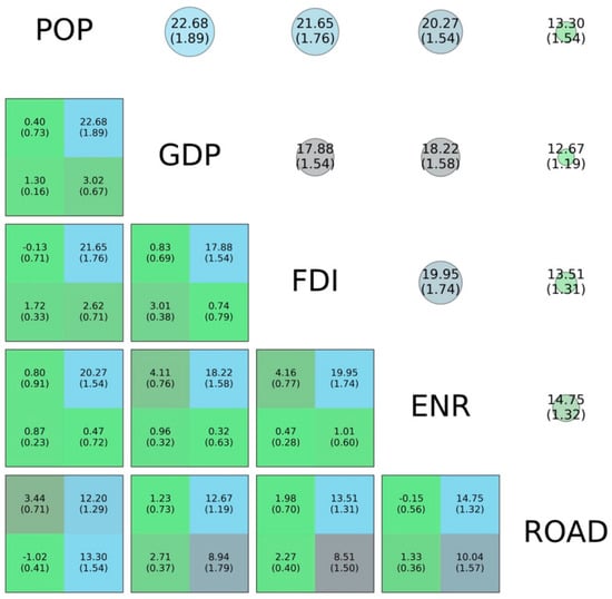
Spatio-Temporal Dynamics of Ecosystem Services in Protected Areas of Greece -
Wind as a Crucial Stress Factor in Green Roof Vegetation -
Public Perceptions of Wildfire Risk: Evidence from the Peak District (UK) -
Spatiotemporal Analysis of Land Subsidence in the Sant’Eufemia Plain (Calabria Region, Italy) Using InSAR Techniques
Journal Description
Land
Land
is an international, cross-disciplinary, peer-reviewed, open access journal on land system science, landscape, soil and water, urban study, land–climate interactions, water–energy–land–food (WELF) nexus, biodiversity research and health nexus, land modelling and data processing, ecosystem services, multifunctionality and sustainability, and is published monthly online by MDPI. The International Association for Landscape Ecology (IALE), International Federation of Landscape Architects (IFLA), European Land-use Institute (ELI), Landscape Institute (LI) and Urban Land Institute (ULI) are affiliated with Land, and their members receive discounts on the article processing charges.
- Open Access— free for readers, with article processing charges (APC) paid by authors or their institutions.
- High Visibility: indexed within Scopus, SSCI (Web of Science), GEOBASE, PubAg, AGRIS, GeoRef, RePEc, and other databases.
- Journal Rank: JCR - Q2 (Environmental Studies) / CiteScore - Q1 (Nature and Landscape Conservation)
- Rapid Publication: manuscripts are peer-reviewed and a first decision is provided to authors approximately 16.4 days after submission; acceptance to publication is undertaken in 2.8 days (median values for papers published in this journal in the first half of 2026).
- Recognition of Reviewers: Reviewers whose reports are timely and of high quality receive an APC discount voucher for a future publication in an MDPI journal. Become a reviewer.
- Companion journal: Drylands.
- Journal Cluster of Environmental Science: Sustainability, Land, Clean Technologies, Environments, Nitrogen, Recycling, Urban Science, Safety, Air, Waste, Aerobiology, Toxics, Pollutants, The Journal of Xenobiotics, Journal of Parks, Green and Environmental Remediation.
Impact Factor:
3.5 (2025);
5-Year Impact Factor:
3.7 (2025)
Latest Articles
Main Agroecological Structure and Landscape Context Shape Insect Biodiversity and Ecosystem Services During Agroecological Transition in Mediterranean Chile
Land 2026, 15(9), 1671; https://doi.org/10.3390/land15091671 - 9 Sep 2026
Abstract
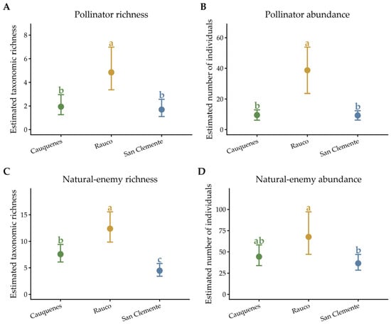
Farm-level ecological organization may influence insect biodiversity, although these relationships can vary among regional settings and may not be captured fully by an aggregated agroecological index. We evaluated associations between the Main Agroecological Structure (MAS), insect biodiversity, community composition, and functional groups associated
[...] Read more.
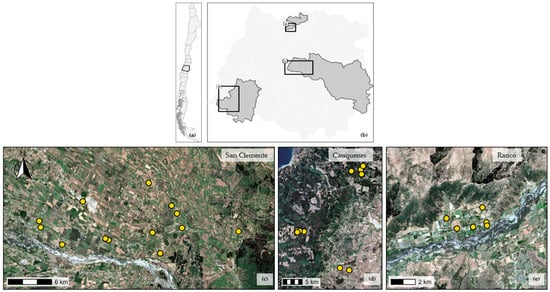
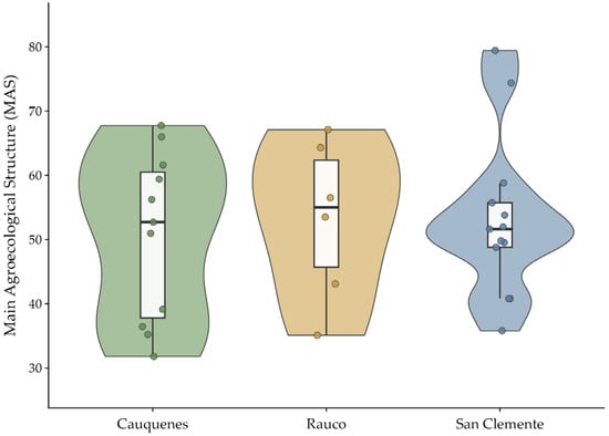
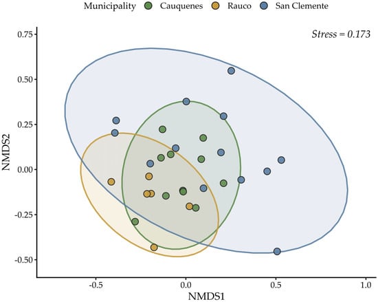
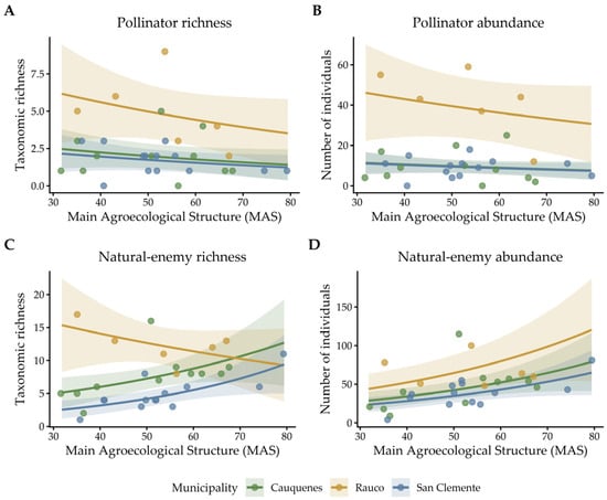
Farm-level ecological organization may influence insect biodiversity, although these relationships can vary among regional settings and may not be captured fully by an aggregated agroecological index. We evaluated associations between the Main Agroecological Structure (MAS), insect biodiversity, community composition, and functional groups associated with potential pollination and biological control across 30 smallholder farms in the Maule Region of Mediterranean Chile. The farms were distributed among Cauquenes, Rauco, and San Clemente, and their immediate surroundings were characterized within 500 m. A total of 3926 individuals representing 144 taxonomic units were collected using standardized yellow pan traps. MAS varied widely among farms (31.8–79.4) but did not differ among municipalities. After accounting for municipality, MAS was not associated with Hill diversity of orders q = 0, q = 1, or q = 2, and no MAS × municipality interaction was detected for these responses. Insect community composition differed among municipalities, although this result was accompanied by heterogeneous multivariate dispersion, whereas the within-municipality association between MAS and community composition was not significant. Pollinator richness and abundance were not associated with MAS. Natural-enemy richness showed a MAS × municipality interaction, with positive associations in Cauquenes and San Clemente but not in Rauco. Natural-enemy abundance increased with MAS, although residual spatial autocorrelation remained after spatial sensitivity analysis. These results indicate that MAS is useful for characterizing farm agroecological organization but was not a general predictor of insect biodiversity. Regional setting, individual MAS components, and the immediate surroundings of each farm should therefore be distinguished when evaluating biodiversity and ecosystem-service potential.
Full article
(This article belongs to the Special Issue Landscapes Across the Mediterranean)
►
Show Figures
Open AccessArticle
Landscape-Driven Spatial Heterogeneity of Ecosystem Service Values and Its Implications for Land Use Planning in the Huaihe River Basin
by
Yongju Yang, Liang Liu, Qianxi Zheng, Xuning Qiao, Hebing Zhang and Yangyang Gu
Land 2026, 15(9), 1670; https://doi.org/10.3390/land15091670 - 9 Sep 2026
Abstract
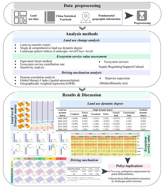
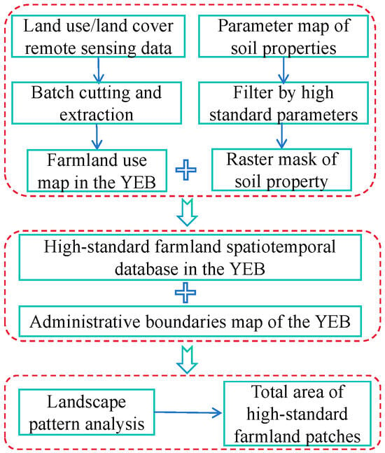
Rapid urbanization in the Huaihe River Basin has reshaped land use and intensified the tension between ecological protection and food security. A key gap is that most basin-scale ecosystem service value (ESV) assessments describe changes in land-cover composition but do not identify how
[...] Read more.
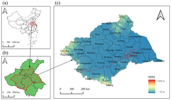
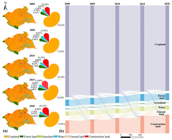
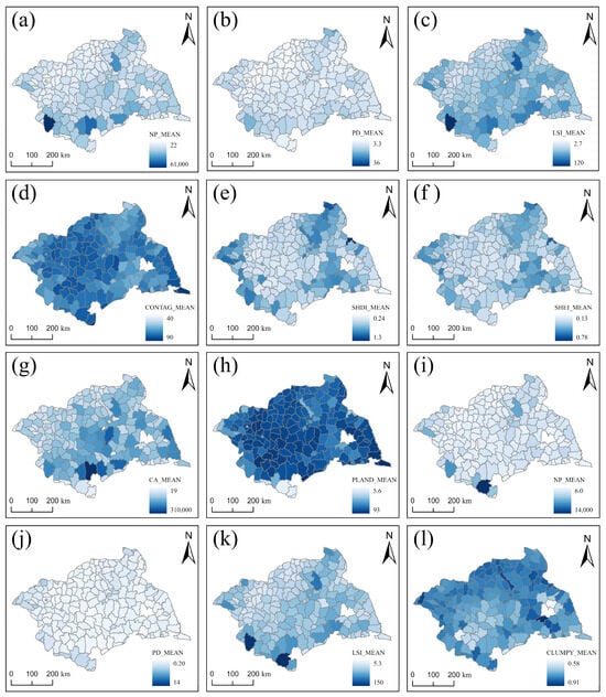
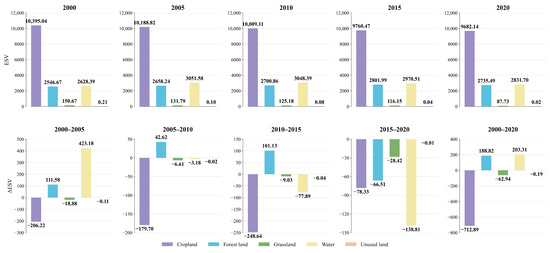
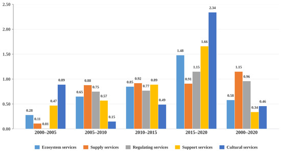
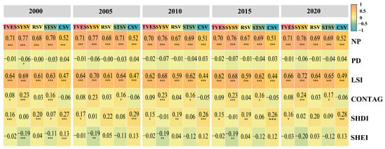
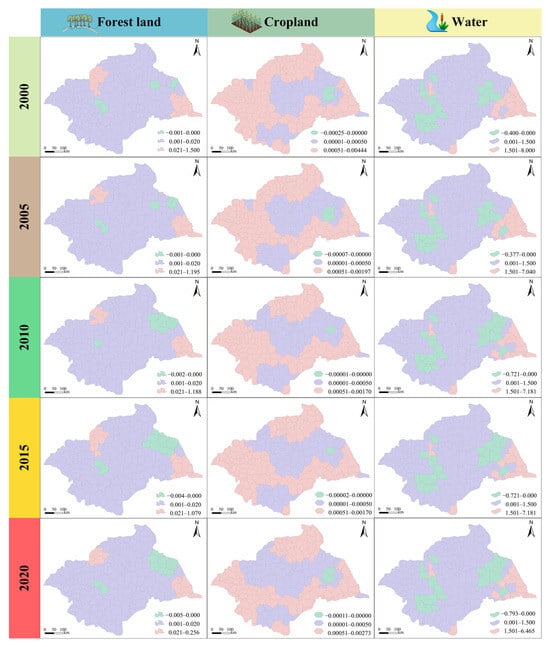
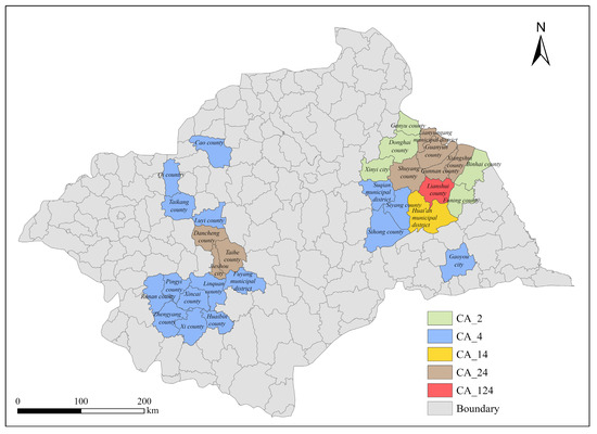
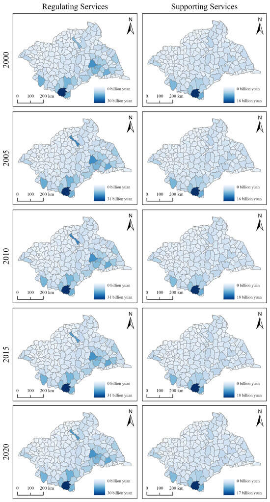
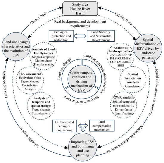
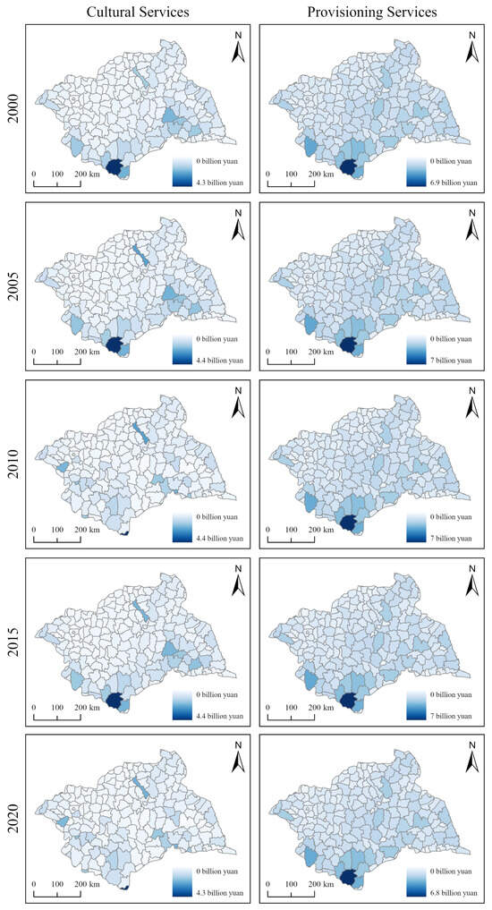
Rapid urbanization in the Huaihe River Basin has reshaped land use and intensified the tension between ecological protection and food security. A key gap is that most basin-scale ecosystem service value (ESV) assessments describe changes in land-cover composition but do not identify how landscape configuration–ESV associations vary across space. Using land use remote sensing images from 2000 to 2020, we quantitatively characterized the spatiotemporal evolution of land use via transfer matrices and landscape pattern indices. By integrating the equivalent value factor method, contribution analysis, spatial correlation analysis, and the geographically weighted regression (GWR) model, we examined the spatiotemporal dynamics and driving mechanisms of ecosystem service value (ESV). Key findings are as follows: (1) From 2000 to 2020, cropland area steadily decreased, while construction and forest land expanded markedly, with a synthetic land-use dynamic degree reaching 9.66%. (2) ESV first rose then fell, showing an overall decline. Forest land (18.882 billion CNY) and water areas (20.331 billion CNY) were the primary contributors. The ESV response to land use change manifested as a trade-off between short-term gains and long-term degradation. (3) Landscape patterns exhibited significant spatial heterogeneity, and ESV correlated strongly with patch number (NP) and landscape shape index (LSI). Class area (CA) emerged as the dominant factor, with CA of forest land, cropland, and water areas exerting the most pronounced effects. Based on the differential driving effects of landscape patterns and identified land use change hotspots, we propose enhancing ecosystem service values and mitigating conflicts between ecological conservation and food security through differentiated ecological engineering and ecological compensation strategies.
Full article
(This article belongs to the Section Land Use, Impact Assessment and Sustainability)
►▼
Show Figures

Figure 1

Open AccessArticle
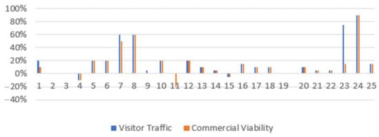
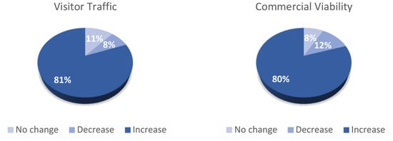
Assessing Heritage-Led Urban Regeneration Through Adaptive Reuse: Evidence from Two Cypriot Khans
by
Andreas Savvides and Despina Parpas
Land 2026, 15(9), 1669; https://doi.org/10.3390/land15091669 - 9 Sep 2026
Abstract
Adaptive reuse has emerged as a key strategy for sustainable urban regeneration by preserving cultural heritage while addressing contemporary socio-economic needs. It also contributes to climate-sensitive urban development through the conservation of embodied carbon, reduction in construction waste, retention of climate-responsive urban forms
[...] Read more.
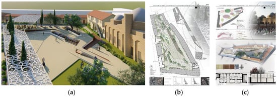
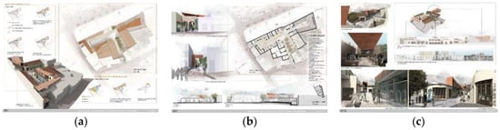
Adaptive reuse has emerged as a key strategy for sustainable urban regeneration by preserving cultural heritage while addressing contemporary socio-economic needs. It also contributes to climate-sensitive urban development through the conservation of embodied carbon, reduction in construction waste, retention of climate-responsive urban forms and enhancement of urban resilience. This study investigates the adaptive reuse of two historic khans in Cyprus using a post-occupancy evaluation (POE) framework to assess their transformation into public and commercial facilities. Combining literature review, on-site observations and structured questionnaires with users and occupants of adjacent properties, the research evaluates accessibility, functional compatibility, urban integration, user satisfaction, economic vitality, environmental quality, management effectiveness and socio-cultural performance. The findings show that successful adaptive reuse extends beyond architectural conservation to strengthen urban vitality, social inclusion and economic activity while supporting the long-term sustainability of historic districts. Well-integrated projects improve walkability, reinforce public life and contribute to climate-sensitive development by extending building life cycles, reducing embodied carbon and preserving passive environmental characteristics. The study demonstrates that post-occupancy evaluation offers an effective framework for assessing the long-term functional, socio-economic and environmental performance of adaptive reuse projects, arguing that heritage conservation and climate-sensitive urban planning are complementary strategies for resilient and sustainable cities.
Full article
(This article belongs to the Special Issue Designing the Climate-Sensitive City: Urban Design and Planning for Urban Resilience)
►▼
Show Figures

Figure 1
Open AccessArticle
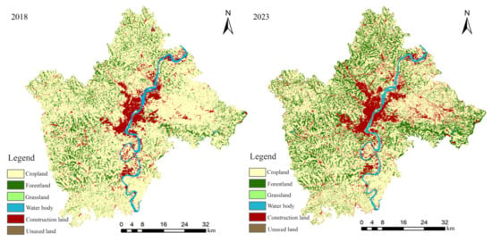
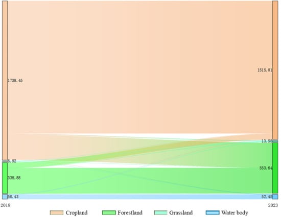
Ecosystem-Service Changes During Ecological Restoration and Urban Expansion in a Medium-Sized Hilly City: A Case Study of Nanchong, China
by
Hongfu Li, Zhijia Wang, Yuelin Wang, Yixin Hu and Ruojing Shen
Land 2026, 15(9), 1668; https://doi.org/10.3390/land15091668 - 9 Sep 2026
Abstract
Understanding how ecological restoration and urban expansion jointly reshape ecosystem-service patterns remains challenging in medium-sized inland hilly cities undergoing rapid land-use change. Nanchong, a representative hilly city in southwestern China, provides an opportunity to examine changes in ecosystem services associated with restoration-related land-use
[...] Read more.
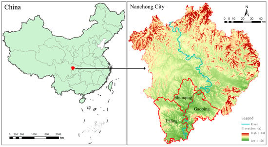
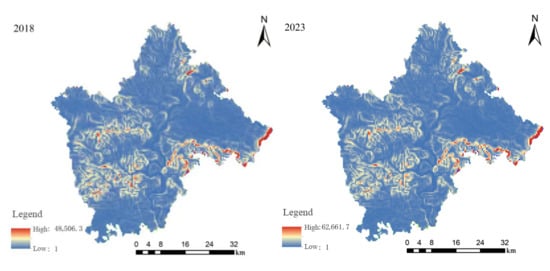
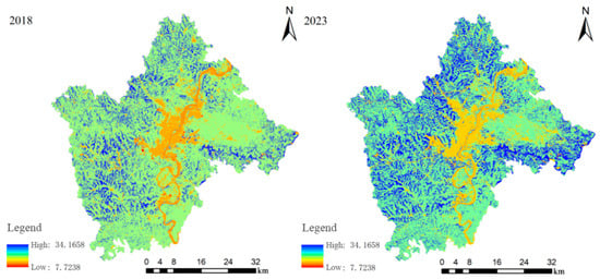
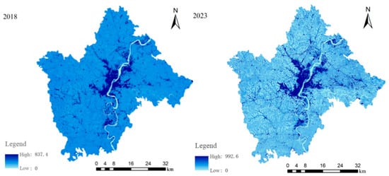
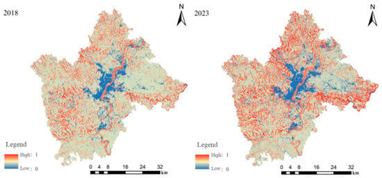
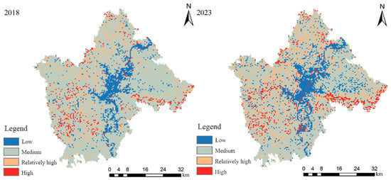
Understanding how ecological restoration and urban expansion jointly reshape ecosystem-service patterns remains challenging in medium-sized inland hilly cities undergoing rapid land-use change. Nanchong, a representative hilly city in southwestern China, provides an opportunity to examine changes in ecosystem services associated with restoration-related land-use transformation and urban development. Using multisource spatial data and the InVEST model, this study quantified changes in soil conservation, carbon storage, water yield, and habitat quality from 2018 to 2023 and established an integrated ecosystem-service zoning framework. Results showed substantial land-use restructuring during the study period, characterized by forest expansion and cropland reduction. Soil conservation increased by 9.52 × 10⁶ t (30.5%), and carbon storage increased by 2.38 × 10⁶ t (3.72%), with the major improvements concentrated in forested hilly regions. Water yield increased by 339.60 × 10⁶ m3 (43.3%), although this change was strongly associated with interannual precipitation variability. Mean habitat quality increased from 0.4443 to 0.4801, while the concurrent increase in habitat degradation indicated increasing spatial differentiation between restored areas and urban fringes. Integrated ecosystem-service zoning revealed a transition from medium-service dominance toward greater spatial polarization, with the proportion of relatively high- and high-service areas expanding from 14.54% to 23.20%. These findings indicate that restoration-related land-use changes were associated with increases in multiple ecosystem services but did not fully offset urbanization pressures, highlighting the need for spatially differentiated green-space management in hilly cities.
Full article
(This article belongs to the Section Landscape Ecology)
►▼
Show Figures

Figure 1
Open AccessArticle
An Improved Simulated Annealing Sampling Method for Land-Cover Accuracy Assessment
by
Fei Chen, Jiachun Hu and Yimin Gao
Land 2026, 15(9), 1667; https://doi.org/10.3390/land15091667 - 9 Sep 2026
Abstract
►▼
Show Figures
Landscape heterogeneity is the core attribute of land cover landscape patterns, and a critical factor that must be considered in land cover accuracy assessment. This paper regards sampling in land cover accuracy assessment as essentially a multi-objective optimization problem, where uniform distribution avoids
[...] Read more.
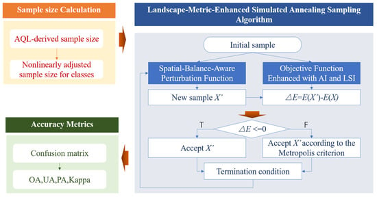
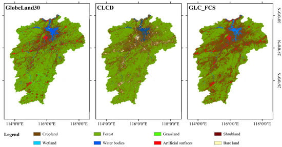
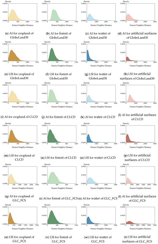
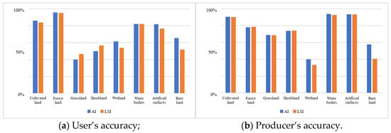
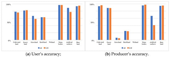
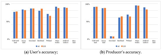
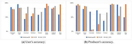
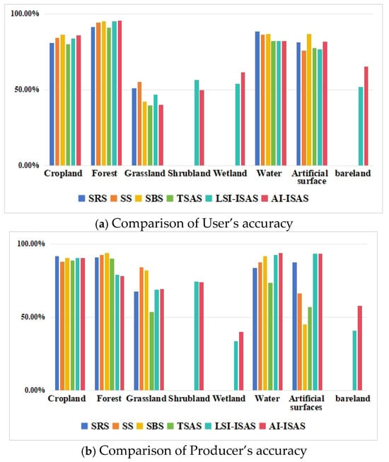
Landscape heterogeneity is the core attribute of land cover landscape patterns, and a critical factor that must be considered in land cover accuracy assessment. This paper regards sampling in land cover accuracy assessment as essentially a multi-objective optimization problem, where uniform distribution avoids spatial autocorrelation while accounting for landscape heterogeneity to enhance the robustness of evaluation results. This paper proposes a land cover accuracy assessment method based on landscape index-improved simulated annealing sampling. By adopting a perturbation function that considers spatial equilibrium, it uses the Aggregation Index (AI) and Landscape Shape Index (LSI) to modify the objective function, optimizing the sample uniformity in low-heterogeneity areas and increasing the sample coverage in high-heterogeneity regions to achieve dual sampling optimization. Taking Jiangxi Province as the study area, the performance of the proposed method is verified through two experiments. In the first experiment, accuracy assessment is carried out on three sets of 30 m land cover products, namely GlobeLand30, CLCD and GLC_FCS. The two sample sets generated by LSI optimization and AI optimization yield highly consistent results in terms of User’s Accuracy (UA), Producer’s Accuracy (PA), area-weighted overall accuracy and Kappa coefficient, which demonstrates that the proposed method has stable cross-product generality. The second comparative experiment with four types of traditional sampling methods shows that the traditional methods cannot complete the accuracy assessment of three rare land categories including wetland, shrubland and bare land, and supplementary samples are required through secondary sampling. The optimized method can complete the PA and UA assessment of all land categories in a single run, while ensuring that the global overall accuracy and Kappa coefficient are consistent with those of traditional methods.
Full article

Figure 1
Open AccessSystematic Review
GIS Applications in Industrial Heritage Architecture: A Systematic Review of Spatial Analysis Approaches
by
Fanfan Lu, Alejandro Jesús González Cruz and Federico Luis del Blanco García
Land 2026, 15(9), 1666; https://doi.org/10.3390/land15091666 - 8 Sep 2026
Abstract
In the field of architectural heritage, industrial built heritage plays an important role. Traditional research methods such as literature studies and field surveys have gradually evolved into digital-twin and machine-learning-based approaches. However, the study of industrial heritage remains a challenge. This study employs
[...] Read more.
In the field of architectural heritage, industrial built heritage plays an important role. Traditional research methods such as literature studies and field surveys have gradually evolved into digital-twin and machine-learning-based approaches. However, the study of industrial heritage remains a challenge. This study employs the PRISMA framework to conduct a systematic review of the existing literature, aiming to elucidate the impact of GIS on industrial heritage sites and its potential limitations. This study conducts a systematic review of GIS-based research on industrial heritage, focusing on studies published between 2000 and 2025. Among the 2166 records initially retrieved from Scopus and the 1771 records initially retrieved from Web of Science, 77 papers were ultimately retained after screening and deduplication. A total of 32 studies were selected based on thematic screening criteria, all of which focused on analysing the spatial characteristics of industrial heritage sites using GIS technology. Among these, 12 core studies were further selected for in-depth qualitative and methodological analysis. These documents form the foundation for exploring research hotspots, methodological approaches, and technological evolution. This review contributes a five-dimensional analytical framework that systematically classifies GIS-based industrial heritage research and identifies eight structural research gaps. The findings indicate that GIS applications remain predominantly focused on spatial mapping and distribution analysis, while their integration with ecological assessment, social and participatory approaches, archaeology, and multi-source technologies remains limited. This review provides a roadmap for integrating advanced spatial analysis tools into future industrial heritage research and planning.
Full article
(This article belongs to the Section Land Planning and Landscape Architecture)
Open AccessArticle
Land Use Restrictions and Livelihood Resilience in Ethnic Minority Communities Around the Giant Panda National Park, China: A Configurational Analysis
by
Yubo Ma, Guoqing Shi and Yitong Guo
Land 2026, 15(9), 1665; https://doi.org/10.3390/land15091665 - 8 Sep 2026
Abstract
Protected areas increasingly reshape land use rules, resource accessibility, and livelihood opportunities for adjacent communities. However, household livelihood resilience under protected-area land use restrictions is rarely explained by a single factor; rather, it is better understood through the combined configurations of spatial constraint
[...] Read more.
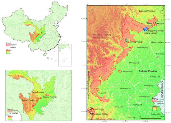
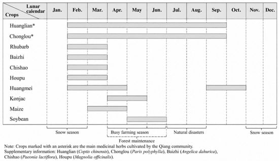
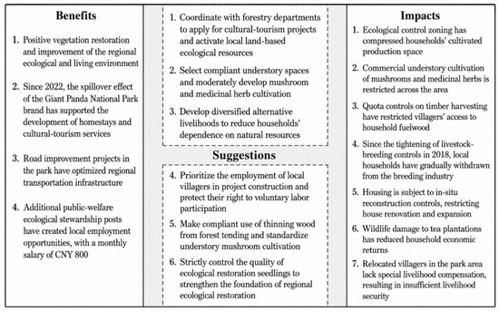
Protected areas increasingly reshape land use rules, resource accessibility, and livelihood opportunities for adjacent communities. However, household livelihood resilience under protected-area land use restrictions is rarely explained by a single factor; rather, it is better understood through the combined configurations of spatial constraint intensity, natural-capital dependence, social capital, and alternative livelihood capacity. Taking households in five sampled Yi, Qiang, and Hui villages around the Giant Panda National Park in China as empirical cases, this study examines the configurational relationships through which land use restrictions are associated with household livelihood resilience. Based on survey data from 200 households in five sampled Yi, Qiang, and Hui villages, supplemented by participatory rural appraisal and semi-structured interviews, we apply fuzzy-set qualitative comparative analysis to identify configurations associated with both high and low livelihood resilience. The results identify two robust high-resilience pathways: an opportunity conversion pathway characterized by weak spatial constraints and strong alternative livelihood capacity, and a dual-capacity support pathway in which social capital and alternative livelihood capacity jointly support livelihood resilience under natural-capital dependence. A third, less robust configuration is interpreted as a supplementary low-exposure livelihood stability configuration rather than active adaptive resilience. The analysis of low livelihood resilience further identifies a constraint-dependent vulnerability pathway characterized by strong spatial constraints, high natural-capital dependence, and the absence of alternative livelihood capacity. These pathways are closely associated with community-specific spatial locations and livelihood traditions. Rather than treating ethnicity as an intrinsic causal factor, this study interprets it as a socially embedded expression of spatial location, livelihood traditions, and informal institutional resources. The findings further suggest that the role of social capital depends not only on its volume but also on whether it can be converted into governance and livelihood-support functions. This study contributes to protected-area livelihood research by clarifying the configurational relationships through which land use restrictions are associated with household livelihood resilience, and it provides implications for differentiated governance and sustainable land management in national park regions.
Full article
(This article belongs to the Section Land Socio-Economic and Political Issues)
►▼
Show Figures

Figure 1

Open AccessArticle
Multi-Scenario Simulation of Land-Use Change and Its Impacts on Ecosystem Services in Hubei Province, China
by
Zhenwei Wang, Wenxuan Zhang, Yilei Wang and Xiaochun Wang
Land 2026, 15(9), 1664; https://doi.org/10.3390/land15091664 - 8 Sep 2026
Abstract
Land-use change is a primary driver of changes in ecosystem services, and different development scenarios imply markedly different ecological responses, with consequences for regional economic development and ecological protection. However, existing studies have mostly focused on historical and current conditions, and quantitative assessments
[...] Read more.
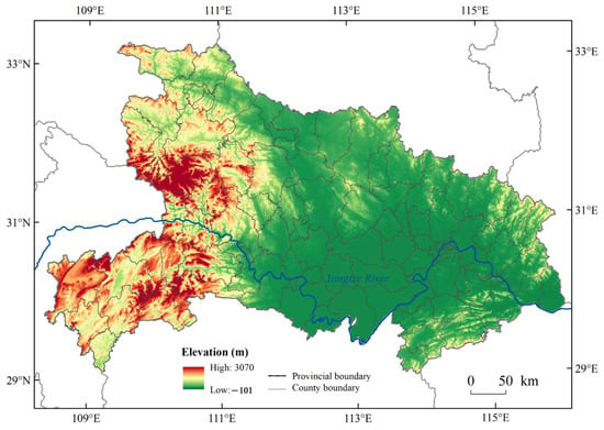
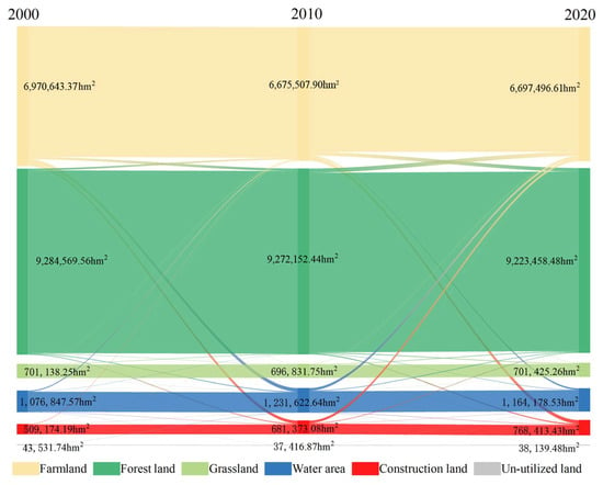
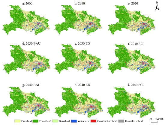
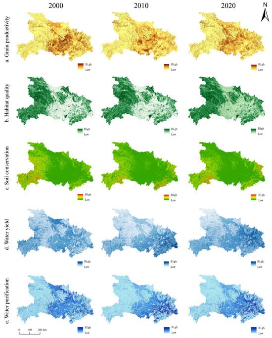
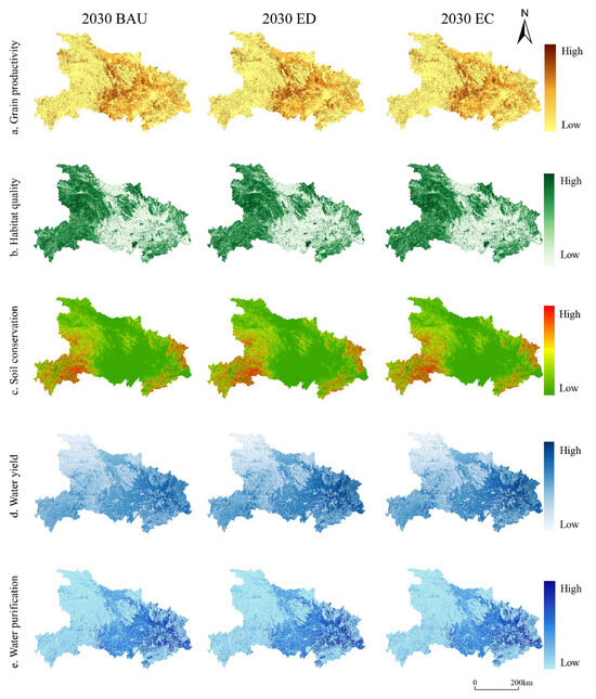
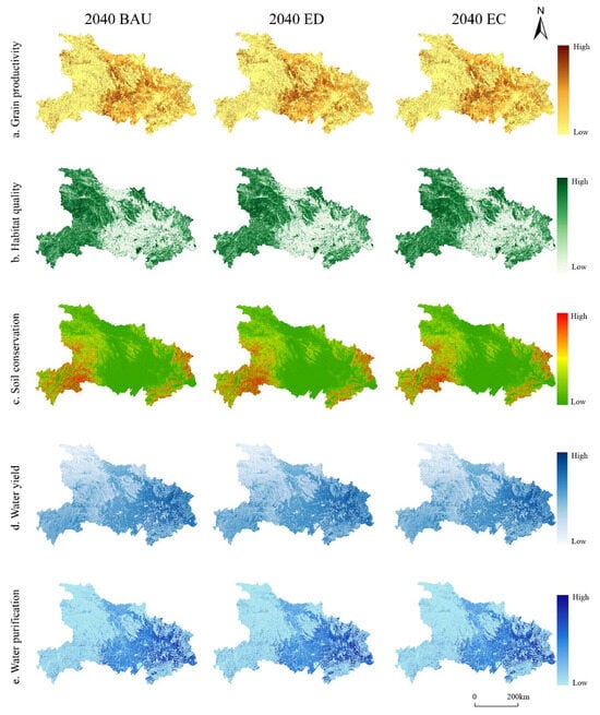
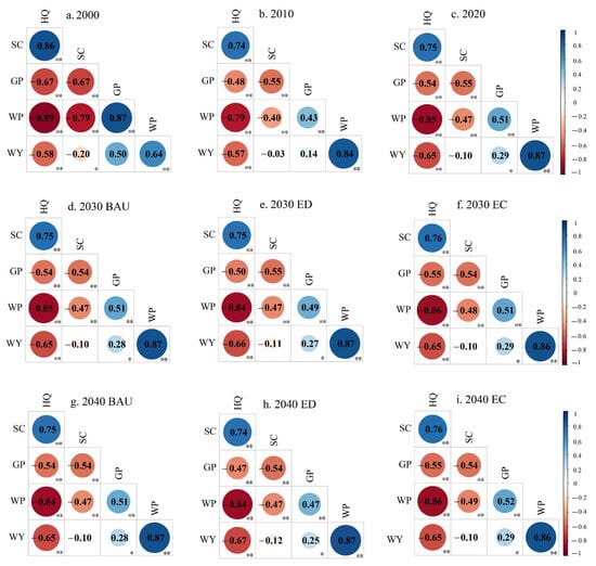
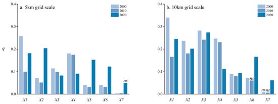
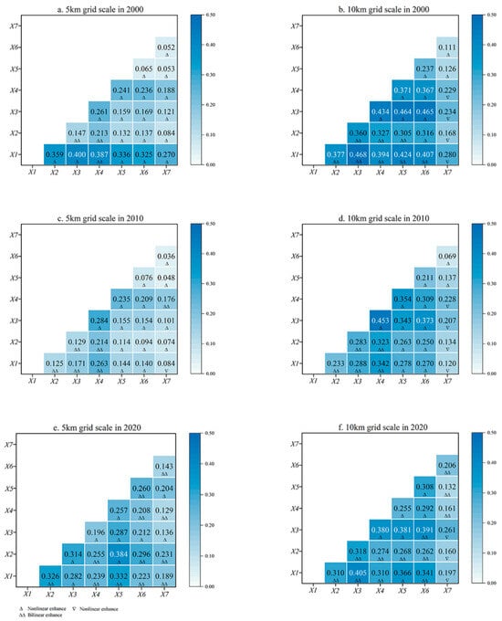
Land-use change is a primary driver of changes in ecosystem services, and different development scenarios imply markedly different ecological responses, with consequences for regional economic development and ecological protection. However, existing studies have mostly focused on historical and current conditions, and quantitative assessments of future ecosystem-service changes under multiple land-use scenarios remain limited. In this study, the patch-generating land-use simulation (PLUS) model was used to simulate land-use patterns of Hubei Province under business-as-usual (BAU), economic development (ED), and ecological conservation (EC) scenarios for 2030 and 2040; five ecosystem services—habitat quality (HQ), soil conservation (SC), grain productivity (GP), water yield (WY), and water purification (WP, proxied by nitrogen export)—were then assessed for 2000–2020 and the future scenarios at a 30 m resolution using InVEST-based modules; Spearman correlation analysis was used to identify trade-offs and spatial associations among services, and the geographical detector model (GDM) was applied at 5 km and 10 km grid scales to quantify the explanatory power of driving factors. The results show that from 2000 to 2020, cultivated land, forest land, grassland, and unused land in Hubei Province decreased by 273,146.76 hm2, 61,111.08 hm2, 8712.99 hm2, and 5392.26 hm2, respectively, while construction land and water areas expanded. Over the same period, GP, SC, and WY increased, nitrogen export grew (indicating a weakening of water purification), and HQ declined continuously from 0.545 to 0.527; the comprehensive ecosystem-service index (CESI) followed a U-shaped trajectory (0.268 in 2000, 0.243 in 2010, and 0.267 in 2020). Under the future scenarios, GP increases markedly under BAU and ED, while HQ and SC deteriorate and nitrogen export rises; under EC, HQ and SC improve significantly, GP first decreases and then increases, and both WY and nitrogen export decline. Among the driving factors, elevation, slope, and NDVI dominate the spatial heterogeneity of ecosystem services, and their explanatory power varies between the 5 km and 10 km scales. These findings provide a reference for optimizing land-resource allocation and for reconciling economic development, food security, and ecological protection in Hubei Province.
Full article
(This article belongs to the Special Issue Land Space Optimization and Governance)
►▼
Show Figures

Figure 1
Open AccessArticle
The Impact of China’s Pilot Policy for Inefficient Land Redevelopment on Urban Green Innovation: Evidence from Machine Learning
by
Yika Shen, Dengguo Wu, Jiabin Zhang, Zhiyuan Li and Weiwen Zhang
Land 2026, 15(9), 1663; https://doi.org/10.3390/land15091663 - 8 Sep 2026
Abstract
Redevelopment of inefficient land constitutes an important pathway for urban renewal and facilitates high-quality urban development. This study combines the traditional difference-in-differences (DID) framework with the state-of-the-art Causal Random Forests (CRF) approach to systematically evaluate the impact of China’s pilot policy targeting inefficient
[...] Read more.
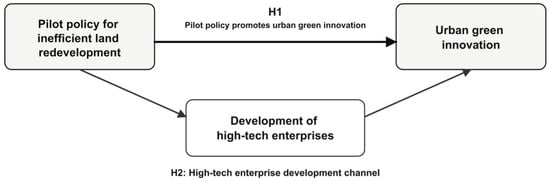
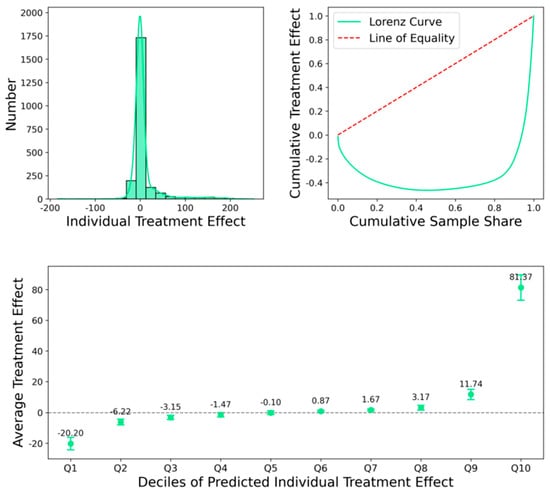
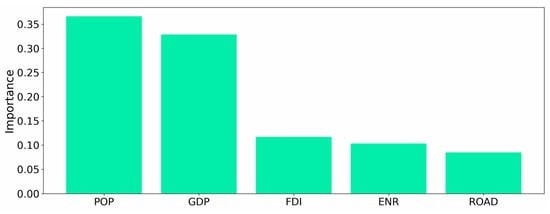
Redevelopment of inefficient land constitutes an important pathway for urban renewal and facilitates high-quality urban development. This study combines the traditional difference-in-differences (DID) framework with the state-of-the-art Causal Random Forests (CRF) approach to systematically evaluate the impact of China’s pilot policy targeting inefficient land redevelopment on urban green innovation, using data spanning from 2009 to 2023. The DID results indicate that, on average, exposure to the pilot policy significantly increases the number of green patents at the city level, with supporting evidence for the parallel trends assumption. Further analysis using CRF reveals substantial heterogeneity in policy effects across cities. In particular, cities with larger populations and higher levels of economic development experience more pronounced increases in green innovation following policy implementation. The mechanism analysis further indicates that the pilot policy promotes the development of nationally certified high-tech enterprises, providing evidence consistent with the proposed high-tech enterprise development channel. This study contributes to the literature by introducing a land policy perspective to the analysis of urban green innovation and by uncovering the heterogeneous impacts of policy interventions. The findings provide empirical evidence for refining place-based land redevelopment policies and coordinating land governance with green innovation in urban renewal.
Full article
(This article belongs to the Special Issue Land Use Transition Pathways: Governance, Resources, and Policies)
►▼
Show Figures

Figure 1
Open AccessArticle
High-Standard Farmland Construction and Agricultural Carbon Performance: Asymmetric Effects on Carbon Mitigation and Sequestration
by
Chunxia Zhu, Hailun Dai, Ruiyang Xiong and Wei Fan
Land 2026, 15(9), 1662; https://doi.org/10.3390/land15091662 - 8 Sep 2026
Abstract
High-Standard Farmland Construction (HSFC) is widely expected to support both food security and low-carbon agriculture in China, yet prevailing assessments treat agricultural carbon performance (ACP) as a single aggregate, obscuring the structural asymmetry between emission mitigation and carbon sequestration. This study examines whether
[...] Read more.
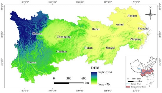
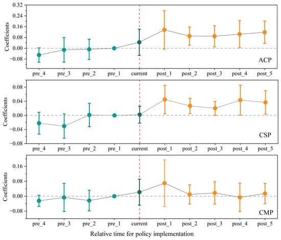
High-Standard Farmland Construction (HSFC) is widely expected to support both food security and low-carbon agriculture in China, yet prevailing assessments treat agricultural carbon performance (ACP) as a single aggregate, obscuring the structural asymmetry between emission mitigation and carbon sequestration. This study examines whether HSFC simultaneously reduces agricultural emissions and enhances carbon sequestration. Using a city-level panel of the Yangtze River Economic Belt (2007–2022), this study treats HSFC as a quasi-experiment and decomposes ACP into carbon sequestration performance (CSP) and carbon mitigation performance (CMP). The results show that HSFC robustly improves overall ACP and CSP, while its effect on CMP is statistically insignificant. Further decomposition indicates that HSFC promotes ACP through both efficiency change and technological change, though these gains are concentrated primarily in the sequestration dimension. Mechanism analysis shows that farmland scale management improves both efficiency and technology adoption, whereas agricultural socialized services promote both channels with a particularly pronounced effect on technological progress; neither channel, however, delivers a strong mitigation effect. In addition, the CSP-enhancing effect is robust across mechanization levels and in major grain-producing areas, whereas it is statistically absent in the upstream reaches characterized by fragmented terrain, and no significant CMP effect emerges in any subgroup. These findings provide new evidence on the climate consequences of farmland policies and offer implications for better aligning food security with agricultural decarbonization.
Full article
(This article belongs to the Section Land Use, Impact Assessment and Sustainability)
►▼
Show Figures

Figure 1

Open AccessArticle
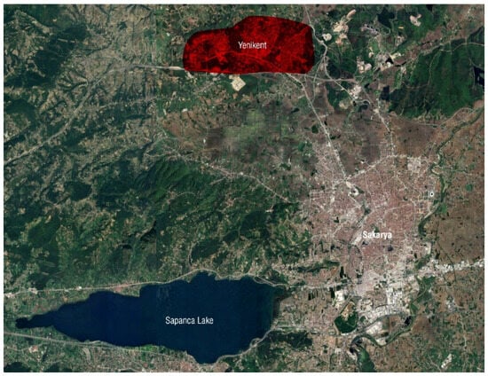
Morphological Factors Shaping the Spatial Vitality of Post-Disaster Commercial Blocks in Yenikent, Türkiye
by
Bekir Huseyin Tekin and Idris Can Iriz
Land 2026, 15(9), 1661; https://doi.org/10.3390/land15091661 - 8 Sep 2026
Abstract
Post-disaster reconstruction often prioritises the rapid delivery of housing and infrastructure, yet the long-term everyday performance of commercial environments embedded in recovery plans remains poorly understood. This study investigates why broadly similar post-disaster commercial blocks in Yenikent (Sakarya, Türkiye) have developed markedly different
[...] Read more.
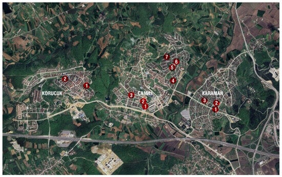
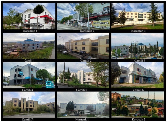
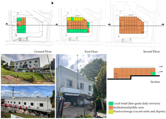
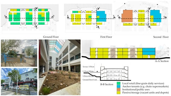
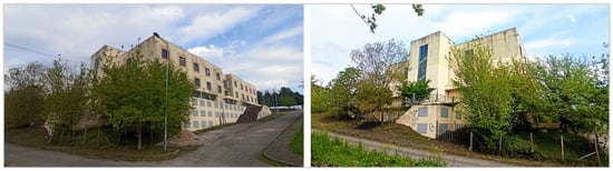
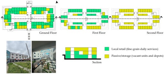
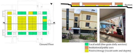
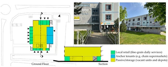
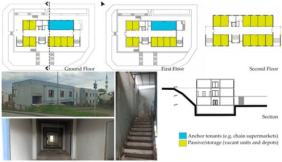
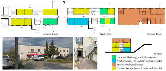
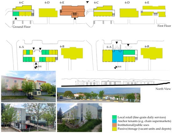
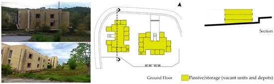
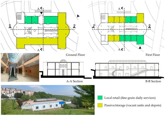
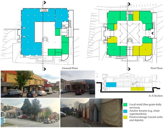
Post-disaster reconstruction often prioritises the rapid delivery of housing and infrastructure, yet the long-term everyday performance of commercial environments embedded in recovery plans remains poorly understood. This study investigates why broadly similar post-disaster commercial blocks in Yenikent (Sakarya, Türkiye) have developed markedly different levels of spatial vitality and long-term everyday use. Yenikent is a state-led satellite city developed after the 1999 Marmara Earthquake, where residential, administrative and service functions were relocated to higher ground as part of a planned secondary urban centre. Twenty-five years later, these purpose-built commercial centres display markedly different levels and forms of everyday use, ranging from active neighbourhood service hubs to abandoned urban voids. Using a multiple-case, mixed-methods design, the study analyses all twelve post-disaster commercial clusters (eighteen buildings) through sectional and morphological analysis, a four-indicator Spatial Vitality Matrix (stationary activity, pedestrian flow, physical permeability, and active occupancy), and 88 semi-structured interviews with businesses, users, and neighbourhood headmen. The findings identify three dominant trajectories: (i) relatively robust service hubs sustained by institutional and neighbourhood anchors, (ii) fragile clusters where vitality is concentrated along accessible ground-level edges while upper or internal spaces shift towards storage, institutional, or ancillary uses, and (iii) functionally obsolete complexes associated with peripheral siting, poor topographic adaptation, and weak accessibility. The results further demonstrate that formal occupancy is not necessarily equivalent to spatial vitality: sectional relationships with the terrain, entrance legibility, façade permeability, and the integration of anchors into shared circulation are closely associated with whether commercial spaces sustain everyday activity. Interview evidence additionally reveals case-specific differences in perceived safety and gendered use of internal corridors and courtyards. The study supports a section-sensitive approach to post-disaster commercial development that prioritises topographic adaptation, legible access, active edges, and the integration of everyday anchors into shared spatial networks.
Full article
(This article belongs to the Special Issue Reframing Urban Morphology: Heritage, Sustainability, and Contemporary Urban Transformation)
►▼
Show Figures

Figure 1

Open AccessArticle
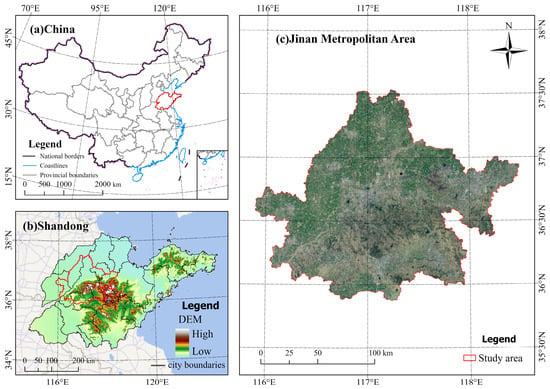
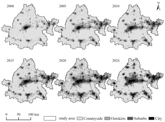
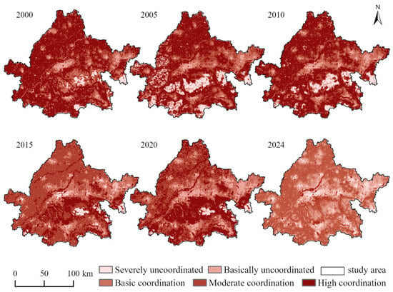
Analysis of Ecosystem Service Value and Driving Factors Under Different Urban–Rural Gradients in the Jinan Metropolitan Area
by
Yaxing Zhu, Haozhe Yu, Chao Fan and Yubin Liu
Land 2026, 15(9), 1660; https://doi.org/10.3390/land15091660 - 8 Sep 2026
Abstract
►▼
Show Figures
The co-evolution of urban–rural spatial transformation and ecosystem services represents a key scientific issue for high-quality basin development and metropolitan ecological governance. As a core growth pole in the lower Yellow River Basin, the Jinan Metropolitan Area (JMA) faces the overlapping pressures of
[...] Read more.
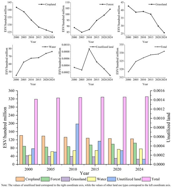
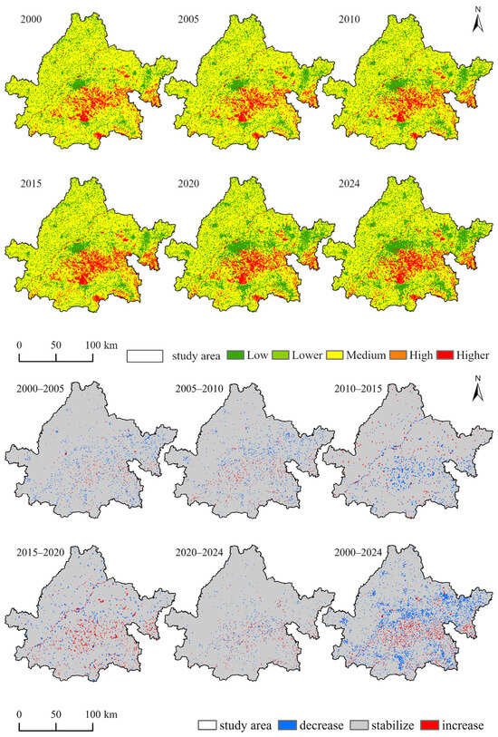
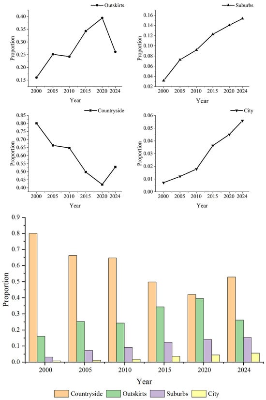
The co-evolution of urban–rural spatial transformation and ecosystem services represents a key scientific issue for high-quality basin development and metropolitan ecological governance. As a core growth pole in the lower Yellow River Basin, the Jinan Metropolitan Area (JMA) faces the overlapping pressures of rapid urbanization and ecological constraints, making it an appropriate case for exploring the interactions between the urban–rural gradient and ecosystem service value (ESV). Based on multisource spatiotemporal datasets for 2000–2024, this study deploys a modified equivalent-factor method, a multidimensional urban–rural gradient model, and a geographic detector to investigate ESV dynamics, the evolution of the urban–rural gradient, and their coupling relationship at a 1 km × 1 km grid scale. The results show that: (1) Total ESV in the JMA increased slightly from 2000 to 2024, with pronounced spatial heterogeneity. High-ESV areas were distributed in the southern mountainous region and along the Yellow River, whereas low-ESV areas were mainly distributed across the northern plains and urban built-up areas. Forestland and water bodies provided the primary foundation for regional ESV stability. (2) Inner-suburban areas expanded rapidly and became the dominant urban–rural transition zone, while rural areas continued to contract. Urban areas exhibited both polarization and sprawl along transportation corridors. (3) The coupling coordination between ESV and the urban–rural gradient exhibited a “high-periphery, low-middle” spatial pattern and declined slightly over time. Land-use change, population density and normalized difference vegetation index (NDVI) serve as core driving factors, with nonlinear threshold effects; pairwise factor interactions exert stronger explanatory power than individual factors. This study advances the analytical framework for examining ESV in basin-metropolitan areas and provides a reference for integrated urban–rural development and ecological protection in similar regions.
Full article

Figure 1
Open AccessArticle
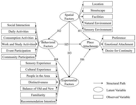
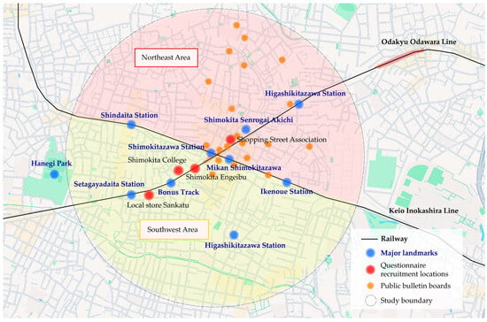
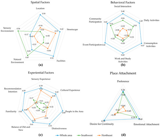
Spatial, Behavioral, and Experiential Associations with Place Attachment Among Engaged Area Users: A Cross-Sectional Study in Shimokitazawa, Tokyo
by
Jingyi Yin, Qin Huang, Yingnan Jiao, Junhua Zhang and Shiro Takeda
Land 2026, 15(9), 1659; https://doi.org/10.3390/land15091659 - 8 Sep 2026
Abstract
Place attachment is important in urban planning and environmental psychology, yet the relationships among spatial, behavioral, and experiential factors and place attachment remain insufficiently understood. This cross-sectional study examined these associations among users engaged with Shimokitazawa, Tokyo. A purposive sample of 127 participants
[...] Read more.
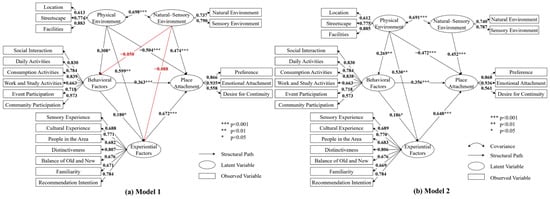
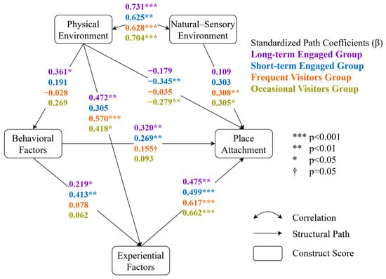
Place attachment is important in urban planning and environmental psychology, yet the relationships among spatial, behavioral, and experiential factors and place attachment remain insufficiently understood. This cross-sectional study examined these associations among users engaged with Shimokitazawa, Tokyo. A purposive sample of 127 participants evaluated three spatial areas each, yielding 381 evaluations nested within respondents. Structural equation modeling (SEM) using maximum likelihood estimation with robust standard errors (MLR) and respondent-level clustering was complemented by exploratory group comparison and qualitative text analysis. The results distinguished Physical Environment from Natural Sensory Environment. Natural Sensory Environment was positively associated with Place Attachment (β = 0.452), whereas Physical Environment showed positive associations with Behavioral (β = 0.269) and Experiential Factors (β = 0.530), as well as a positive total indirect association with Place Attachment (β = 0.472). Exploratory analyses identified four descriptive orientations—identity-, everyday-life-, repeated-experience-, and perception-oriented—but provided no statistically robust evidence of between-group differences in structural associations. The findings provide preliminary support for a conceptual framework linking spatial, behavioral, and experiential factors with place attachment and highlight the potential importance of environmental quality and opportunities for repeated engagement. Given the cross-sectional, non-probability sample and single-case context, causal, developmental, and broader population-level generalizations require further investigation.
Full article
(This article belongs to the Special Issue Urban Planning and the Quality of Life in Neighborhoods: The Built Environment’s Impact on Resident Well-Being)
►▼
Show Figures

Figure 1

Open AccessArticle
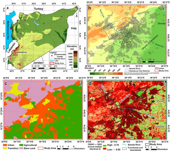
Nocturnal Surface Urban Heat Island Dynamics in a Semi-Arid Mediterranean City: Evidence from Damascus
by
Almustafa Abd Elkader Ayek, Mohannad Ali Loho, Motrih Al-Mutiry, Norah Alshahrani and Mena Elassal
Land 2026, 15(9), 1658; https://doi.org/10.3390/land15091658 - 8 Sep 2026
Abstract
Although nocturnal surface urban heat islands, which impede physiological recovery during rest, have been characterized in many cities worldwide, Syria’s capital, Damascus, situated in the Eastern Mediterranean region, remains without a quantitative, multi-time assessment of its nocturnal thermal behavior. This study delivers that
[...] Read more.
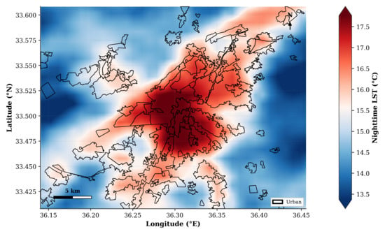
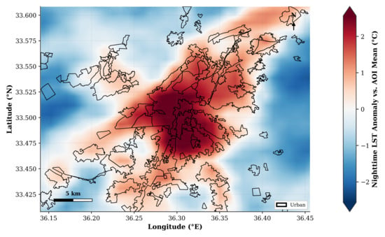
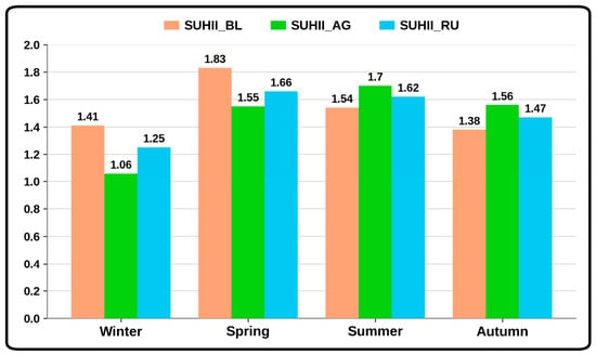
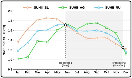
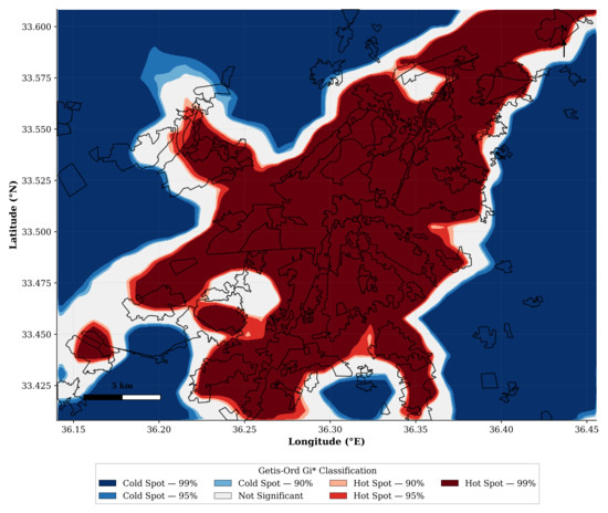
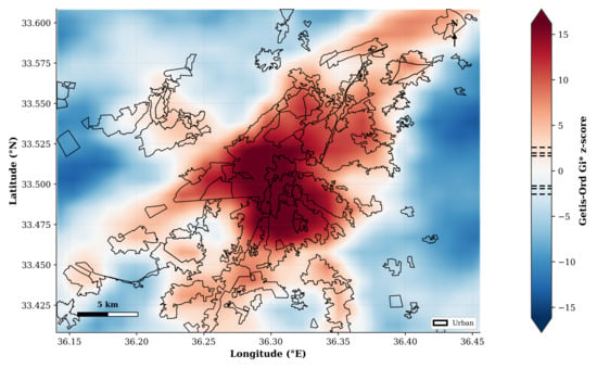
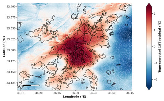
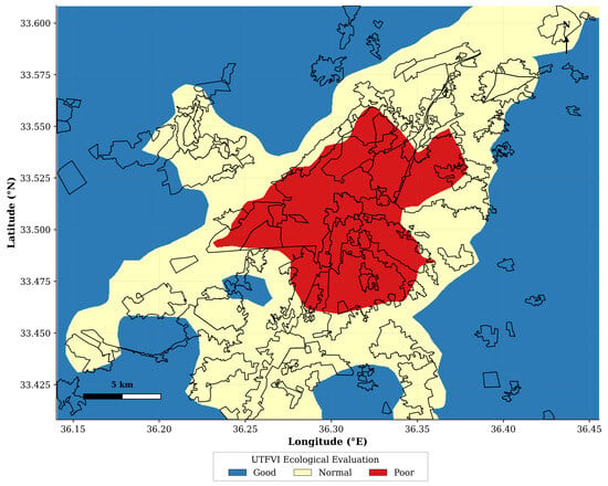
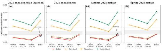
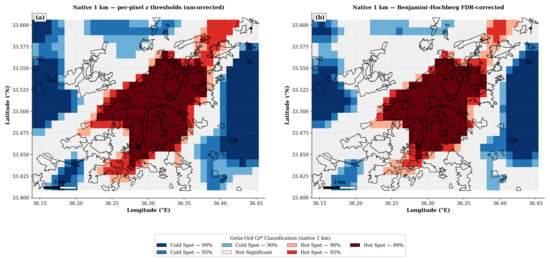
Although nocturnal surface urban heat islands, which impede physiological recovery during rest, have been characterized in many cities worldwide, Syria’s capital, Damascus, situated in the Eastern Mediterranean region, remains without a quantitative, multi-time assessment of its nocturnal thermal behavior. This study delivers that assessment for the city and its surroundings during 2023–2025, using 138 MOD11A2 (Collection 6.1) nighttime scenes processed within Google Earth Engine and Python. Six complementary axes were integrated: the thermal gradient across functional classes, the anomaly field, SUHI intensity (SUHII) against three rural references, the Getis–Ord Gi* statistic, a multivariate topographic regression, and the Urban Thermal Field Variance Index (UTFVI). A consistent nocturnal gradient emerged (urban: 16.28 °C; bare land: 14.74 °C), with an annual intensity of 1.50 °C, about 36% above the global mean. A genuine seasonal crossover between the bare-land and agricultural references occurred in June, reflecting the phenological cycle of soil thermal inertia. Topography explained only ~10% of the spatial variance (R2 = 0.102), and the topographically corrected intensity retained about 90% of its original value. The Gi* statistic identified a single central hot spot (p < 0.01 after false-discovery-rate correction, with significance adjusted for spatial autocorrelation) that coincided spatially with the “poor” thermal-stress nucleus delineated by UTFVI, covering 11.92% of the study area. The convergence of these complementary lines of evidence confirms the persistence of the phenomenon and provides a scientific basis for climate-aware urban planning in semi-arid Mediterranean cities.
Full article
(This article belongs to the Special Issue Sustainable Landscape Planning for Urban Heat Island Mitigation: Strategies, Tools, and Emerging Challenges)
►▼
Show Figures

Figure 1
Open AccessArticle
A Study on Multi-Tier Categorical Soil Classification Based on Decoupled Parallel Deep Learning: A Case Study in the Southern Foothills of Qilian Mountains
by
Yueyong Pang, Heng Xu, Sen Zou, Liming Zhu, Lizhi Miao and Jieying Zheng
Land 2026, 15(9), 1657; https://doi.org/10.3390/land15091657 - 7 Sep 2026
Abstract
High-precision, multi-tier categorical soil classification faces critical bottlenecks, including the neglect of spatial context by conventional pixel-based models, the error cascade propagation phenomenon in multi-level classification networks, and the disruption of geophysical directional anisotropy by traditional geometric data augmentation. To address these challenges,
[...] Read more.
High-precision, multi-tier categorical soil classification faces critical bottlenecks, including the neglect of spatial context by conventional pixel-based models, the error cascade propagation phenomenon in multi-level classification networks, and the disruption of geophysical directional anisotropy by traditional geometric data augmentation. To address these challenges, in this study, we propose a multi-level soil classification model based on MTSC-ResNet-Trans, which organically couples residual convolutional blocks with a 3-layer Transformer encoder to model long-range spatial dependencies. The framework integrates a geospatial-safe data augmentation pipeline to preserve the topological fidelity of absolute geographic coordinates alongside four decoupled parallel multi-task classification heads to substantially suppress inter-level error propagation. Evaluated in the Southern Foothills of Qilian Mountains using 18 environmental covariates, the framework achieves an Overall Accuracy of 0.8931 at the Great Group level under conventional random splitting. Under a distance-stratified spatial evaluation—which isolates the contribution of spatial autocorrelation to accuracy estimates—the framework maintains robust performance, with MTSC-ResNet-Trans consistently outperforming pixel-based baselines (Random Forest) by approximately 3.7 percentage points even at spatial separation distances exceeding 400 m. This protocol transparently decomposes predictive accuracy into a component attributable to spatial proximity and a component reflecting reduced spatial proximity performance. Across the four taxonomic levels, accuracy decay is suppressed to 5.11%. Although spatial-block cross-validation indicates a lower regional extrapolation accuracy (OA = 0.7389 ± 0.0671), the decoupled parallel framework provides an effective and robust baseline for high-resolution regional digital soil mapping.
Full article
Open AccessArticle
Integrating Collaborative Governance and Environmental Performance Assessment for Nature-Based Solutions: The euPOLIS Experience in Palermo
by
Ferdinando Trapani, Simona Colajanni and Luisa Lombardo
Land 2026, 15(9), 1656; https://doi.org/10.3390/land15091656 - 7 Sep 2026
Abstract
Nature-Based Solutions (NBSs) are increasingly recognized as strategic tools for climate adaptation and urban regeneration, yet their implementation requires balancing environmental performance, territorial identity, and governance feasibility. This article investigates the application of the euPOLIS H2020 methodology in Palermo, Italy, focusing on the
[...] Read more.
Nature-Based Solutions (NBSs) are increasingly recognized as strategic tools for climate adaptation and urban regeneration, yet their implementation requires balancing environmental performance, territorial identity, and governance feasibility. This article investigates the application of the euPOLIS H2020 methodology in Palermo, Italy, focusing on the proposed transformation of Villa Turrisi—a residual peri-urban agricultural area representing one of the last remnants of the historical Conca d’Oro landscape—into a new public green infrastructure within the framework of the new Municipal Development Plan (PRG/PUG). This study examines how a structured co-design process involving municipal actors, citizens, and local associations can be coupled with ecosystem service assessments. Rather than selecting a single optimal design, the analysis evaluates two alternative vision scenarios—a multifunctional framework aligned with euPOLIS principles and an intensive urban forest model—to generate quantitative and qualitative baseline data. Environmental indicators (carbon sequestration, microclimatic regulation, and hydrological resilience) are used not as deterministic selection criteria but as theoretical decision-support evidence within a predominantly qualitative, value-driven local planning process. The core contribution of this work lies in demonstrating the operational transferability of the euPOLIS framework from front-runner to follower cities within a Mediterranean planning context. The Palermo case shows how quantitative environmental simulations can effectively inform—rather than dictate—participatory governance, heritage preservation, and regulatory feasibility. Ultimately, this article offers a transferable planning and policy framework that bridges European NBS research with municipal decision-making, providing actionable insights for integrating climate-resilient green infrastructure into local urban plans.
Full article
(This article belongs to the Special Issue Ecosystem Services for Sustainable and Inclusive Urban Planning)
Open AccessArticle
Cloud-Based Mapping of Soil Erosion Susceptibility for Catchment Prioritisation in the Western Balkans Using a Modified Erosion Potential Method
by
Ivica Milevski, Bojana Aleksova and Siniša Polovina
Land 2026, 15(9), 1655; https://doi.org/10.3390/land15091655 - 7 Sep 2026
Abstract
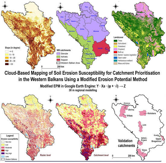
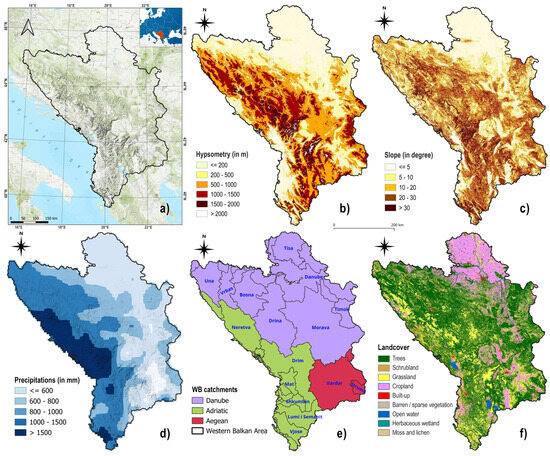
Soil erosion is recognised as one of the most pervasive forms of land degradation across the Western Balkans (WB), a 208,052 km2 region for which its erodible substrates, contrasting climates, and long history of land-use pressure produce highly variable erosion regimes. This
[...] Read more.
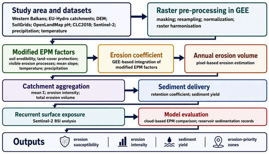
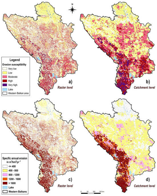
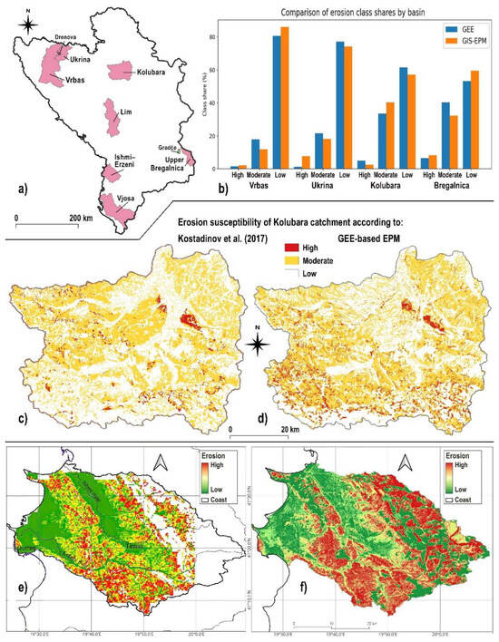
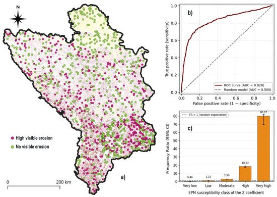
Soil erosion is recognised as one of the most pervasive forms of land degradation across the Western Balkans (WB), a 208,052 km2 region for which its erodible substrates, contrasting climates, and long history of land-use pressure produce highly variable erosion regimes. This study delivers the first regional-scale assessment of soil erosion susceptibility for the entire WB through a cloud-based implementation of a modified Erosion Potential Method (EPM) in Google Earth Engine (GEE). The computation was performed at 30 m resolution and aggregated across 9524 catchments derived from the EU-Hydro database, with the dimensionless erosion coefficient (Z) serving as the primary susceptibility metric. The modelled patterns reveal a strong north–south asymmetry in erosion intensity: The highest country-level coefficients were obtained for Albania (0.47), North Macedonia (0.38) and Montenegro (0.37), while Serbia (0.29) and Bosnia and Herzegovina (0.28) recorded lower regional means. About 19.8% of the WB area falls within catchments classified as highly to very highly susceptible, with such basins concentrated along the Adriatic-facing mountain front and across the Aegean headwaters. Validation was carried out at three complementary levels, including point-based statistical validation on 1379 field- and orthophoto-verified points distributed across the WB, which yielded an AUC = 0.828. Although the proposed framework should not be considered a substitute for fine-scale, field-based modelling, it provides a transparent, reproducible, and scalable basis for regional screening, catchment prioritisation, and the design of soil-conservation and land-management interventions across the WB.
Full article
(This article belongs to the Special Issue Soil Erosion Dynamics and Landform Evolution: Mapping, Modelling and Monitoring)
►▼
Show Figures

Graphical abstract
Open AccessArticle
Bridging Tree-Level Quantification and Continuous Forest Structural Characterization: A Framework Integrating Tree Counts and Crown Structure from UAV Imagery Using Forest Structural Zones
by
Guangzhi Yan, Yifang Sun and Xilin Zhou
Land 2026, 15(9), 1654; https://doi.org/10.3390/land15091654 - 7 Sep 2026
Abstract
Object detection and instance-segmentation methods have been widely used to locate trees and delineate individual crowns from aerial imagery, providing valuable tree-level information for estimating tree abundance, density, and spatial distribution. These variables form important inputs for quantitative assessments of forests and urban
[...] Read more.
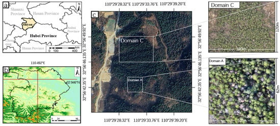
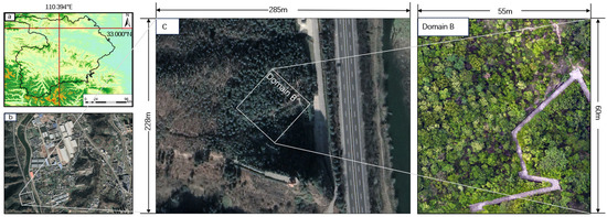
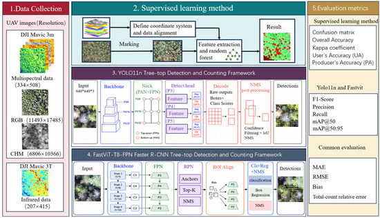
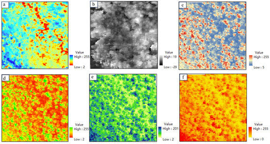
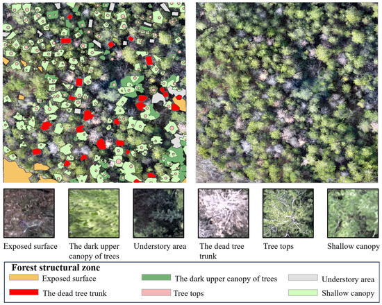
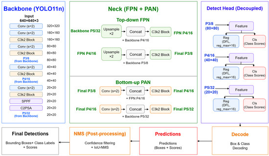
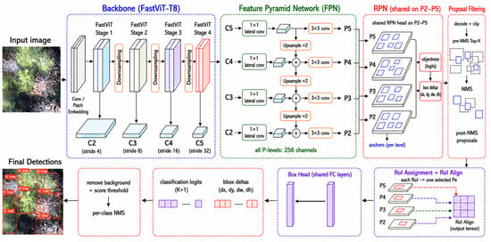
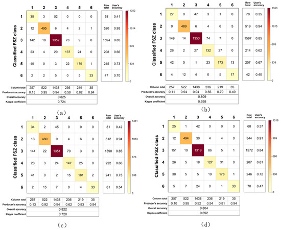
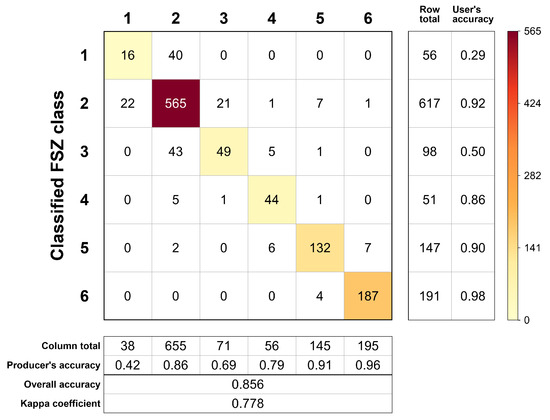
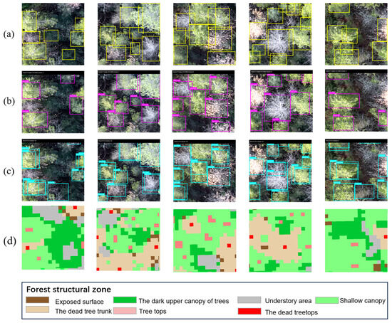
Object detection and instance-segmentation methods have been widely used to locate trees and delineate individual crowns from aerial imagery, providing valuable tree-level information for estimating tree abundance, density, and spatial distribution. These variables form important inputs for quantitative assessments of forests and urban greenery, including analyses of thermal environments, pollutant dispersion and removal, and carbon storage and sequestration. Yet, existing approaches remain centered on individual trees or crowns and lack a spatially continuous representation of forest structural conditions, leaving a gap between discrete tree-level objects and continuous forest structural patterns. To address this gap, this study develops a geospatial multilayer supervised-classification framework that jointly estimates visible tree-top abundance and maps continuous forest structural zones (FSZs), thereby integrating tree-count information with spatially explicit structural characterization. The FSZ workflow was evaluated against YOLO11n and FastViT-T8-FPN Faster R-CNN in Domain A and independently evaluated in Domain B (an urban-fringe planted landscape). It achieved an OA of 0.825 and absolute TCRE of 14.29% in Domain A and an OA of 0.856 and absolute TCRE of 19.15% in Domain B, demonstrating good applicability across both scenarios. By linking tree-top abundance with landscape-scale structural patterns, the FSZ framework provides a complementary spatial data product for forest and urban-greenery quantification and offers a foundation for subsequent assessments of microclimate regulation, air-pollution management, carbon accounting, and green-infrastructure performance.
Full article
(This article belongs to the Special Issue Urban Green Spaces as Multi-Functional Infrastructure: Integrating Climate Resilience, Environmental Health and Social Equity)
►▼
Show Figures

Figure 1

Open AccessArticle
Differentiated Agricultural Spaces and Uneven Geographies of Protest Under Market-Oriented Agricultural Reform: A Comparison of Punjab and Madhya Pradesh, India
by
Jin Pang, Jingjing Wen, Yuheng Zhou and Shibo Wen
Land 2026, 15(9), 1653; https://doi.org/10.3390/land15091653 - 7 Sep 2026
Abstract
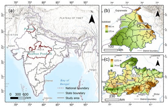
When national-level market-oriented agricultural reforms enter regional agricultural systems with different land-use structures, production infrastructure, and degrees of institutional dependence, they may generate spatially uneven political responses. Focusing on Punjab and Madhya Pradesh, India, this study integrates agricultural reform policy documents, public procurement
[...] Read more.
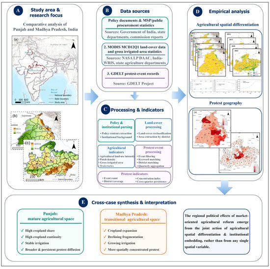
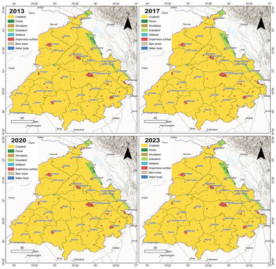
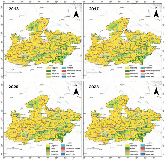
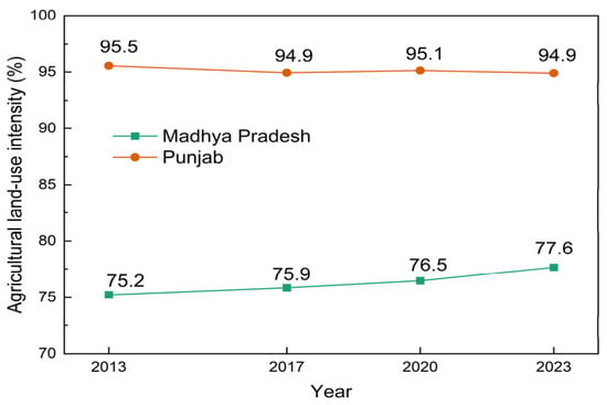
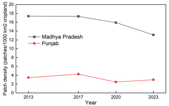
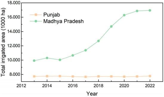
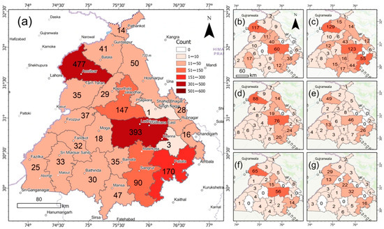
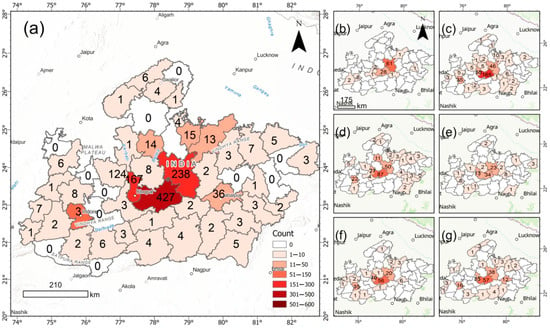
When national-level market-oriented agricultural reforms enter regional agricultural systems with different land-use structures, production infrastructure, and degrees of institutional dependence, they may generate spatially uneven political responses. Focusing on Punjab and Madhya Pradesh, India, this study integrates agricultural reform policy documents, public procurement statistics, MODIS land-cover data for 2013, 2017, 2020, and 2023, irrigation statistics for the 2013–2014 to 2022–2023 agricultural years, and protest-event records from the Global Database of Events, Language, and Tone (GDELT) Event Database for 25 September 2020 to 11 December 2021. We examine agricultural land-use intensity, cropland fragmentation, gross irrigated area, and the district-level coverage, spatial concentration, and cross-quarter persistence of protest events. Punjab maintained an agricultural land-use intensity of approximately 95%, a cropland patch density of 2.50–4.27 patches per 1000 km2, and only a 0.56% increase in gross irrigated area, indicating a mature agricultural space characterized by intensive land use, continuous cropland, and stable irrigation. By contrast, agricultural land-use intensity in Madhya Pradesh increased from 75.24% to 77.63%, cropland patch density declined from 17.40 to 13.15 patches per 1000 km2, and gross irrigated area increased by 70.87%, indicating a transitional agricultural space marked by gradual land expansion, increasing cropland connectivity, and rapid irrigation growth. Protest events were more widespread and persistent in Punjab but more concentrated in Madhya Pradesh. These findings show that agricultural land expansion, cropland fragmentation, or irrigation growth alone cannot explain regional differences in farmer protests. Rather, the observed regional differences are more consistent with an interpretation emphasizing the interaction between differentiated agricultural spaces and existing institutional arrangements, including minimum support prices, public procurement, and Agricultural Produce Market Committee markets. The study develops an integrated institutional–spatial framework for explaining uneven regional responses to uniform agricultural reform.
Full article
(This article belongs to the Special Issue Land Economics, Institutions, and Resource Governance: Socio-Economic and Political Interplays)
►▼
Show Figures

Figure 1
Open AccessArticle
A Threshold-Based Framework for Spatial Pre-Assessment of Coastal Salt Marsh Restoration Suitability
by
Yan Zheng, Wenhai Lu, Lijing Deng, Chang Liu, Xiaoqian Li and Xiaoxia Hu
Land 2026, 15(9), 1652; https://doi.org/10.3390/land15091652 - 6 Sep 2026
Abstract
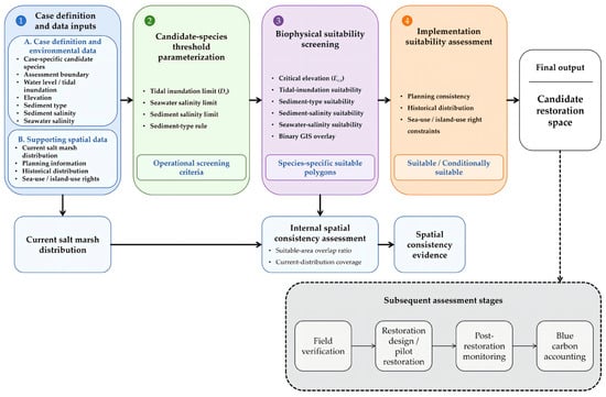
Coastal salt marsh restoration can support blue carbon sequestration, but spatial pre-assessment is needed to identify where environmental conditions support vegetation establishment before restoration design and carbon accounting. This study developed a threshold-based framework for spatial pre-assessment of coastal salt marsh restoration suitability.
[...] Read more.
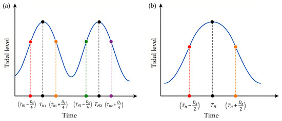
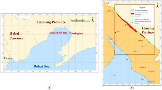
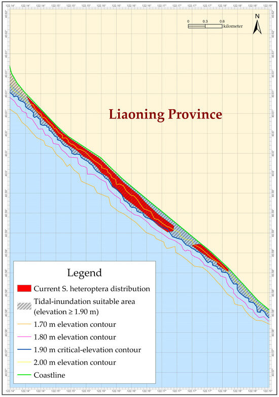
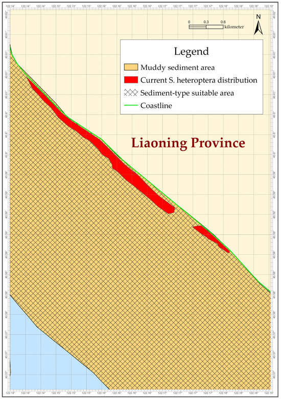
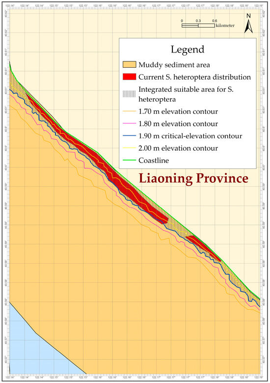
Coastal salt marsh restoration can support blue carbon sequestration, but spatial pre-assessment is needed to identify where environmental conditions support vegetation establishment before restoration design and carbon accounting. This study developed a threshold-based framework for spatial pre-assessment of coastal salt marsh restoration suitability. The framework combines species-specific limits for tidal inundation duration, seawater salinity and sediment salinity with sediment type in a geographic information system workflow. Tidal inundation limits are translated into critical-elevation boundaries, and retained polygons are examined against planning, historical-distribution and use-right conditions. A general threshold library was compiled for five representative native salt marsh species, while regional records define the candidate set for each application. In Yingkou, China, Suaeda heteroptera and Phragmites australis formed the candidate set. For S. heteroptera, the 3 h d−1 inundation limit corresponded to a critical elevation of 1.90 m. July 2024 sediment salinity (0.96–1.08%) and September 2025 seawater salinity (29.715–29.825‰) met the corresponding screening limits for S. heteroptera and excluded P. australis. The integrated restoration-suitability area covered 76.5 ha, and 99.5% of the mapped current S. heteroptera distribution fell within it. The framework identifies candidate restoration space for field verification, restoration planning and subsequent carbon accounting.
Full article
(This article belongs to the Special Issue Carbon Cycling and Carbon Sequestration in Wetlands)
►▼
Show Figures

Figure 1
Journal Menu
► ▼ Journal Menu-
- Land Home
- Aims & Scope
- Editorial Board
- Reviewer Board
- Topical Advisory Panel
- Early Career Editorial Board
- Instructions for Authors
- Special Issues
- Topics
- Sections & Collections
- Article Processing Charge
- Indexing & Archiving
- Editor’s Choice Articles
- Most Cited & Viewed
- Journal Statistics
- Journal History
- Journal Awards
- Society Collaborations
- Conferences
- Editorial Office
Journal Browser
► ▼ Journal BrowserHighly Accessed Articles
Latest Books
E-Mail Alert
News
8 September 2026
Land Webinar | Geomatics Supporting the Ecological, Digital and Energy Transition: Innovative Approaches for Sustainable Urban and Landscape Management, 8 September 2026
Topics
Topic in
Agronomy, Climate, Crops, Grasses, Horticulturae, Land, Plants
Reframing Strategies for a Low Carbon Future in Agricultural Systems
Topic Editors: M. Ibrahim Khalil, Bruce OsborneDeadline: 8 October 2026
Topic in
Agriculture, Agronomy, Crops, Land, Plants, Sustainability
Irrigation and Fertilization Management for Sustainable Agricultural Production
Topic Editors: Shihong Yang, Zewei Jiang, Ivan Francisco Garcia TejeroDeadline: 15 October 2026
Topic in
Agronomy, Crops, Land, Plants, Atmosphere, Nitrogen, Agriculture, Methane
Multi-Objective Optimization of Staple Crop Production for Yield, Carbon Sequestration, and Greenhouse Gas Mitigation
Topic Editors: Qiang Xu, Wei Yang, Ziyin Shang, Peng ZhangDeadline: 31 October 2026
Topic in
Applied Sciences, GeoHazards, Geosciences, Land, Remote Sensing
Remote Sensing and Geological Disasters
Topic Editors: Gan Feng, Qiao Lyu, Yunfeng Ge, Guoqing LiDeadline: 30 November 2026
Conferences
19–21 October 2026
The 6th International Electronic Conference on Remote Sensing—Global Perspectives for the Next Generation in Earth Observation

Special Issues
Special Issue in
Land
Urban Land Use Planning in Europe: A Comparative Perspective
Guest Editors: Ioannis A. Pissourios, Georgia Gemenetzi, Giancarlo CotellaDeadline: 10 September 2026
Special Issue in
Land
Sustainable Forest Landscape Management Towards Ecosystem Services and Biodiversity (Second Edition)
Guest Editors: Guillermo Martinez-Pastur, Robert Baldwin, Mónica Del Rosario Toro-Manríquez, Serban ChivulescuDeadline: 11 September 2026
Special Issue in
Land
Urban Morphology: A Perspective from Space (3rd Edition)
Guest Editors: Marco Maretto, Nicola MarzotDeadline: 15 September 2026
Special Issue in
Land
Human Activity-Driven Land Use Change: Insights and Perspectives from Novel Data and Methodologies
Guest Editors: Zhiqi Yang, Brice Hanberry, Wenpeng DuDeadline: 16 September 2026
Topical Collections
Topical Collection in
Land
Land Use Transitions and Land System Science
Collection Editor: Hualou Long
Topical Collection in
Land
Collection for the International Association for Landscape Ecology (IALE)
Collection Editor: Weiqi Zhou