1. Introduction
Protected areas are important institutional instruments for biodiversity conservation and ecosystem management, but their expansion and strengthened governance have also reshaped land use rules, resource accessibility, and livelihood choices in adjacent communities. Existing studies have shown that protected areas do not merely establish ecological boundaries; their governance arrangements often reconfigure local residents’ actual access to forests, grasslands, water sources, wild resources, and tourism opportunities, thereby being associated with both positive and negative social impacts [
1,
2]. In some protected areas, resource access restrictions and stronger enforcement may undermine the stability of traditional livelihoods, especially for households highly dependent on natural resources, because conservation rules directly reshape the spatial organization of production activities and income sources [
3]. At the same time, protected areas may also create new livelihood opportunities through nature-based tourism, ecological compensation, green products, and community-based co-management [
4]. Therefore, protected-area land use restrictions should not be understood simply in terms of either “losses” or “benefits”. Rather, they may constrain traditional resource use while simultaneously opening up market-oriented and green transformation opportunities for some communities.
Recent protected-area governance research increasingly emphasizes the role of local communities, Indigenous peoples, and marginalized groups as key actors in conservation. Dawson et al. argue that Indigenous peoples and local communities are not only recipients of conservation impacts but also essential actors in achieving effective and equitable conservation [
5]. Studies on inclusive conservation further suggest that protected-area governance should pay attention not only to ecological objectives but also to social equity, participation mechanisms, benefit sharing, and local knowledge [
6]. When community interests, institutional trust, and livelihood needs are overlooked, implicit social conflicts may emerge within protected areas and weaken residents’ compliance with, and cooperation in, conservation rules [
7]. This suggests that livelihood resilience in national parks and other strictly protected areas cannot be explained solely by the intensity of ecological regulation; it also depends on whether communities have the capacity to participate in governance, obtain compensation, access markets, and develop alternative livelihoods.
China’s national park system provides an important context for understanding the relationship between protected-area land use restrictions and community livelihood resilience. As one of China’s first national parks, the Giant Panda National Park is expected to simultaneously protect flagship species, maintain ecosystem integrity, and promote regional green development. Existing studies on the Giant Panda National Park have found that local participation affects community perceptions of co-management performance [
8]. Research on residents’ livelihoods in Chinese national parks also shows that regulatory land use restrictions and wildlife conflicts may disrupt land-based livelihood activities and affect livelihood stability [
9]. From the perspective of ecological carrying capacity, the Giant Panda National Park also faces the challenge of coordinating habitat protection with local socioeconomic development [
10]. These studies provide important insights into community participation, livelihood impacts, and ecological coordination in the Giant Panda National Park. However, explaining household livelihood resilience under land use restrictions requires a conceptual framework that links spatial constraints, livelihood dependence, social capital, and alternative livelihood capacity.
Livelihood resilience provides a useful concept for analyzing household adaptation and transformation under protected-area restrictions. The sustainable livelihoods framework emphasizes that livelihood outcomes depend on multiple asset combinations, including natural, human, social, financial, and physical capital; recent scholarship has further incorporated institutional change, power relations, and uncertainty into a revised livelihood framework for the twenty-first century [
11]. In studies of forest communities and resettled communities, livelihood resilience is commonly understood as the capacity of households to maintain, adapt, or reorganize their livelihood systems when exposed to external disturbances [
12,
13]. For households in national park-adjacent areas, spatial constraint intensity, natural-capital dependence, social capital, and alternative livelihood capacity are key dimensions for understanding household livelihood resilience. Spatial constraint intensity here does not refer to spatial exposure in a general sense; rather, it denotes the degree of overlap and conflict between national park governance zones and households’ traditional livelihood activity spaces. Natural-capital dependence reflects households’ economic reliance on regulated forests, grasslands, understory collection, and grazing spaces. Alternative livelihood capacity indicates whether households have the practical basis to shift from resource-dependent income to non-farm employment, nature-based tourism, household businesses, or skill-based income.
Social capital plays a distinctive role in shaping livelihood resilience in protected-area communities. Existing studies show that social networks can enhance household livelihood resilience under ecological compensation and payments for ecosystem services programs [
14] and can strengthen rural households’ capacity for coping with risk through information access, mutual support, and resource linkage [
15]. A systematic review of social capital and food security also suggests that social capital can improve community system stability through information sharing, mutual assistance, and social support [
16]. However, social capital does not necessarily translate into livelihood resilience. For ethnic minority communities around national parks, the key issue may not be merely the “volume” or presence of social capital but how local networks are connected with formal governance arrangements, compensation schemes, project resources, market channels, and institutional negotiation. In other words, social capital is more likely to become a resilience-enhancing resource under protected-area land use restrictions when it helps households connect with ecological compensation, project resources, market channels, and institutional negotiation.
Theoretically, the mechanisms through which protected-area land use restrictions are associated with household livelihood resilience do not follow a simple linear logic. Access theory argues that resource use depends not only on property rights but also on people’s ability to actually gain, control, and benefit from resources [
17]. In the context of national parks, even when formal ownership of land or forestland remains unchanged, households’ ability to enter and use traditional livelihood spaces may be weakened by regulatory boundaries and management rules. Meanwhile, the same restrictive condition may be associated with different livelihood outcomes when combined with different livelihood traditions, social capital, and alternative livelihood opportunities. Conventional regression models usually focus on the independent net effects of variables and are less able to reveal conjunctural causation, equifinality, and causal asymmetry. Fuzzy-set qualitative comparative analysis is well suited to examining such configurational relationships, because it identifies how different combinations of conditions can be associated with the same outcome and explains why high resilience and low resilience are not simply mirror images of each other [
18,
19].
Despite these advances, three gaps remain. First, existing studies have often examined protected-area livelihood issues through policy effects, participation, compensation, tourism development, or single livelihood outcomes, while paying less attention to how multiple household and community conditions combine with one another. Second, land use restrictions are often treated as a uniform institutional background, although households differ substantially in the extent to which their livelihood spaces overlap with national park governance zones. Third, although recent studies have begun to examine livelihood resilience in Giant Panda National Park communities, less is known about how spatial constraint intensity, natural-capital dependence, social capital, and alternative livelihood capacity jointly form configurations associated with high and low livelihood resilience. These gaps call for a configurational analysis that treats land use restrictions not as a homogeneous policy shock but as differentiated livelihood space constraints experienced by households in specific village contexts.
Most recently, Zhang et al. examined livelihood resilience in Giant Panda National Park communities and distinguished a dual pathway of inherent and learned resilience [
20]. Their study provides important evidence that livelihood resilience involves both structural endowments and adaptive processes in conservation–tourism contexts. However, the present study differs from and extends this recent work in three respects. First, it focuses specifically on land use restrictions as spatial governance constraints, rather than treating protected-area governance mainly as a general conservation or tourism development context. Second, it conceptualizes spatial constraint intensity as the experienced overlap and conflict between national park governance zones and households’ traditional livelihood activity spaces. Third, it uses fsQCA to identify configurations associated with both high and low livelihood resilience among households in five sampled villages, thereby highlighting equifinality and causal asymmetry under differentiated land use restrictions.
Based on these discussions, this study takes households in five sampled Yi, Qiang, and Hui villages around the Giant Panda National Park as empirical cases. Drawing on survey data from 200 households, supplemented by participatory rural appraisal and semi-structured interviews, we apply fuzzy-set qualitative comparative analysis to examine how spatial constraint intensity, natural-capital dependence, social capital, and alternative livelihood capacity combine in configurations associated with household livelihood resilience. This study addresses three questions. First, what configurations of conditions are associated with high and low household livelihood resilience under national park land use restrictions? Second, how are these configurations embedded in different sampled village settings, livelihood traditions, and spatial relationships with national park governance zones? Third, how can the role of social capital be interpreted when it appears in both high- and low-resilience configurations, and under what conditions may local networks help connect households with governance and livelihood-support resources?
The contributions of this study are threefold. First, this study advances protected-area livelihood research from single-factor or net-effect explanations to configurational explanations of livelihood resilience under land use restrictions. Second, it incorporates spatial constraint intensity into the analytical framework and conceptualizes it as the experienced overlap and conflict between national park governance zones and household livelihood activity spaces. Third, it provides a qualitatively informed interpretation of the conditional role of social capital, suggesting that social capital is more likely to support livelihood resilience when local networks can be connected with governance, market, compensation, or project-related support functions.
2. Materials and Methods
2.1. Study Area
The Giant Panda National Park is one of China’s first national parks and spans Sichuan, Shaanxi, and Gansu provinces. It is designed to protect the giant panda as a flagship species, enhance habitat connectivity, and maintain regional ecosystem integrity [
21,
22]. Compared with conventional nature reserves, the national park system has strengthened ecological red lines and zoning-based management requirements, while also redefining how adjacent communities can use forests, grasslands, understory collection areas, and nature-based tourism resources. The Giant Panda National Park therefore provides a representative context for examining the relationship between protected-area land use restrictions and livelihood resilience in adjacent communities.
In this study, the term “ethnic minority communities around the national park” refers to ethnic minority administrative villages located outside or near the boundary of the Giant Panda National Park, where residents’ traditional livelihood activity spaces overlap with, are adjacent to, or come into conflict with the park’s governance zones to varying degrees. This study does not focus on changes in formal land ownership. Rather, it examines how national park governance boundaries and management rules affect households’ actual ability to enter, use, and benefit from traditional livelihood spaces. Accordingly, spatial constraint intensity refers to the degree of overlap and conflict between national park governance zones and households’ traditional livelihood activity spaces, such as grazing areas, collection sites, and understory planting areas.
Five sampled villages were selected from Shimian County, Beichuan County, and Qingchuan County in Sichuan Province. These villages are inhabited mainly by Yi, Qiang, and Hui residents and differ markedly in elevation, terrain, livelihood traditions, resource dependence patterns, and access to alternative livelihoods. They therefore provide a comparative framework for analyzing household livelihood resilience under different forms of spatial constraint.
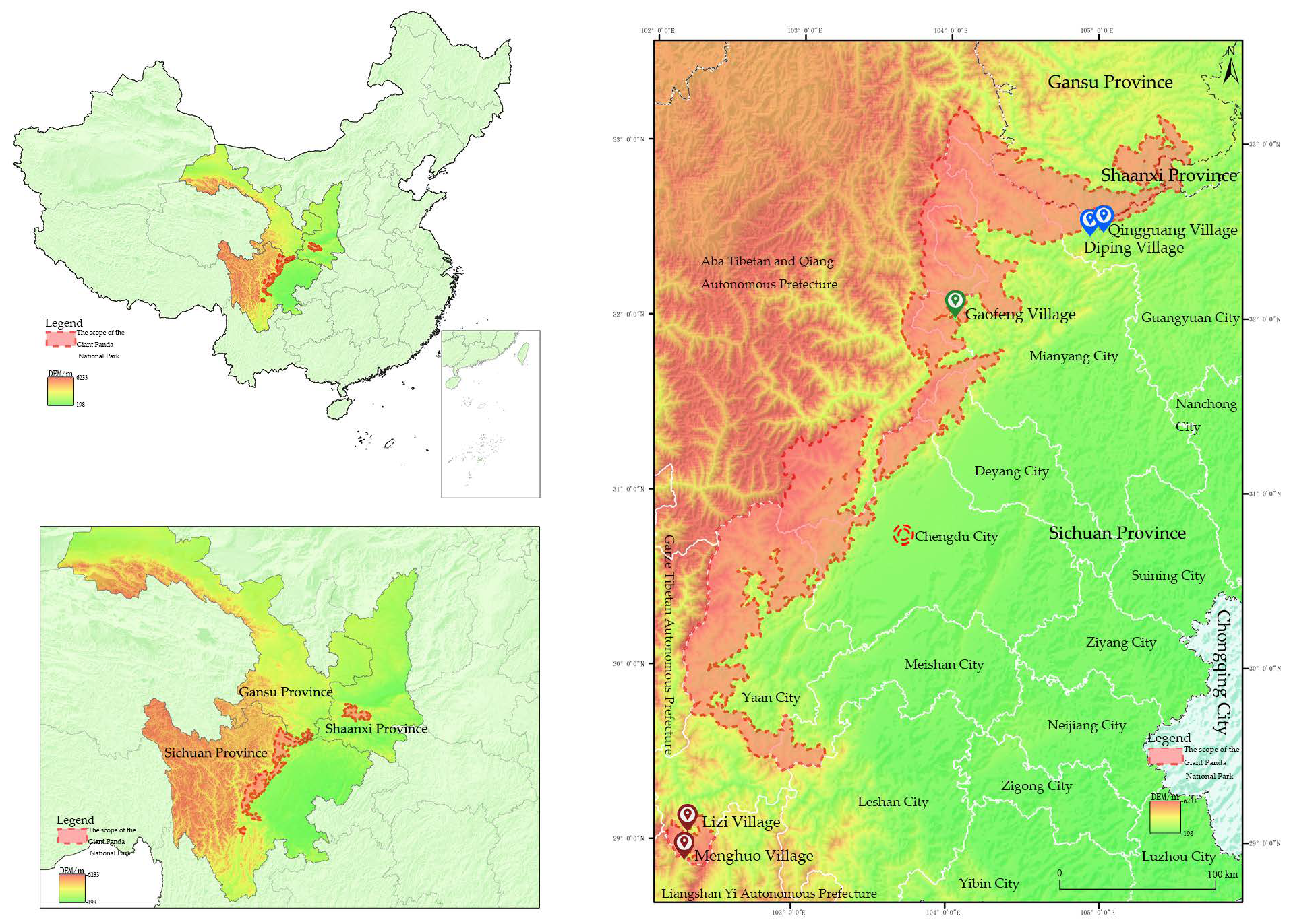
Menghuo Village and Lizi Village in Shimian County are located in the Daxiangling–Xiaoxiangling section of the Giant Panda National Park. These Yi villages are situated in high mountain valleys or steep mid-mountain slopes, where traditional livelihoods have mainly relied on free-range cattle and sheep grazing, supplemented by limited highland agriculture. Because traditional grazing spaces highly overlap with the core protection zone or the general control zone of the national park, Yi households face relatively strong spatial constraints. Gaofeng Village in Beichuan County is located in the Minshan section of the park and represents a Qiang community in a mid-mountain forest area. Qiang households have long relied on understory medicinal herb cultivation as an important livelihood source. Since some planting areas are located within the general control zone, spatial constraints are expressed mainly as restrictions on livelihood development space rather than as complete livelihood deprivation. Diping Village and Qingguang Village in Qingchuan County are located in low mountain hills and river valley terraces on the southern margin of the Minshan Mountains. Hui households mainly rely on tea cultivation, rice farming, migrant work, and, for some households, agritainment or homestay businesses. Their traditional livelihood activity spaces have a relatively low degree of overlap with the national park’s governance zones, and their access to alternative livelihoods is comparatively stronger.
These differences in spatial location, livelihood traditions, and organizational resources make the five villages suitable empirical sites for analyzing the differentiated mechanisms of household livelihood resilience under national park land use restrictions. The location of the study area is shown in
Figure 1, and the basic characteristics of the five sampled villages are summarized in
Table 1. This study does not treat ethnicity itself as an essential causal factor. Instead, ethnicity is understood as a social carrier through which spatial location, livelihood traditions, and informal institutional resources are historically embedded. From this perspective, the differences among sampled Yi, Qiang, and Hui villages are reflected primarily in different configurations of spatial constraint intensity, natural-capital dependence, the ways in which social capital is connected with governance and livelihood support resources, and alternative livelihood capacity.
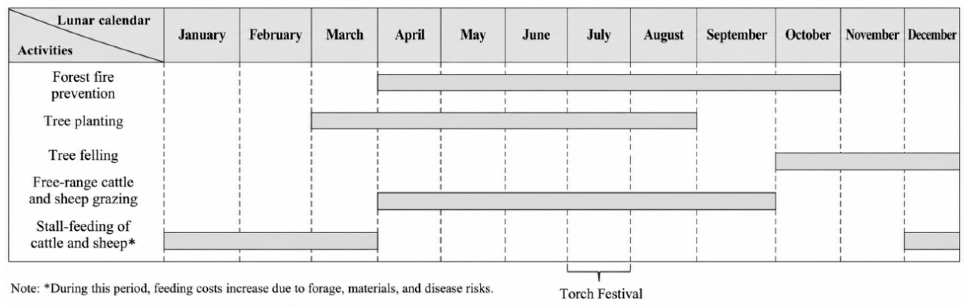
Figure 2,
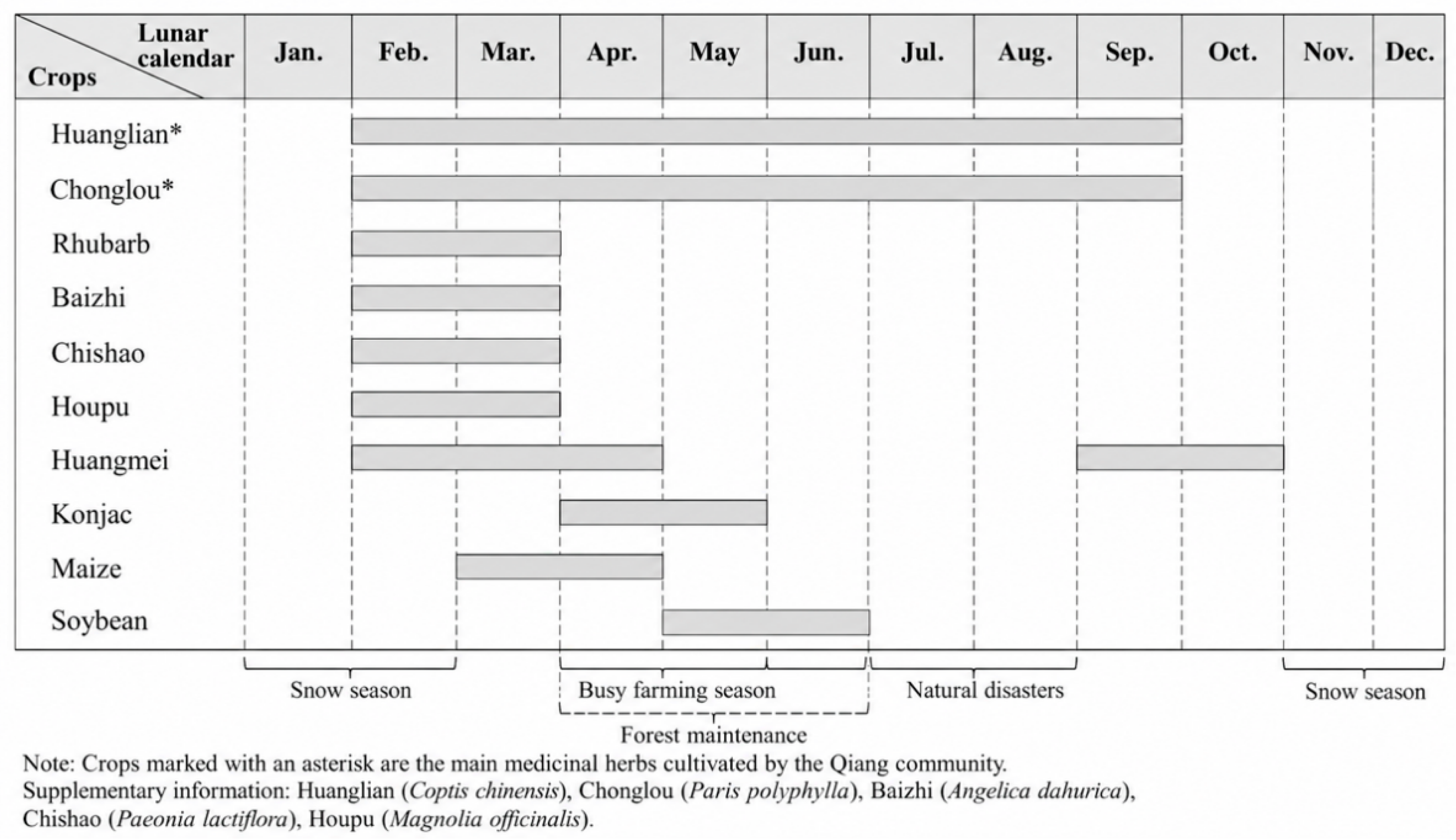
Figure 3 and
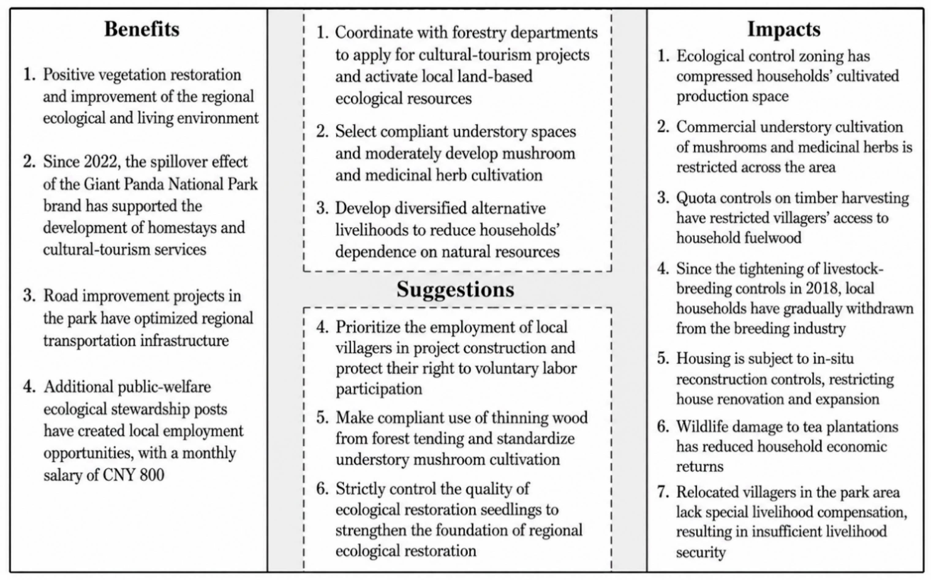
Figure 4 illustrate the livelihood calendars and spatial governance relationships of the sampled Yi, Qiang, and Hui villages, providing field-based context for interpreting differences in spatial constraint intensity, natural-capital dependence, and alternative livelihood capacity.
2.2. Data Sources
The data used in this study were collected through multiple rounds of fieldwork conducted in the five sampled villages from June to November 2025. The research team combined household surveys, participatory rural appraisal, and semi-structured interviews to obtain both household-level quantitative data and community-level qualitative evidence.
First, household surveys were conducted in the five villages, yielding 200 valid household questionnaires. A quota-informed purposive sampling strategy was adopted to cover households from different sampled villages, livelihood types, ethnic groups, and degrees of spatial constraint. The sample included 40 households from Menghuo Village, 38 from Lizi Village, 46 from Gaofeng Village, 38 from Diping Village, and 38 from Qingguang Village. The questionnaire included modules on household demographic characteristics, income structure, resource dependence, organizational participation, mutual-aid networks, perceptions of spatial regulation, alternative livelihood capacity, and livelihood coping capacity. All questionnaires were checked for completeness and logical consistency during fieldwork. No questionnaire was excluded because no missing values or clearly invalid responses were identified in the final analytical dataset.
Second, one participatory rural appraisal session was conducted in each sampled village, with a total of 142 villagers participating. These sessions focused on livelihood changes before and after the establishment of the national park, traditional resource use practices, the impacts of spatial regulation, community organizational resources, and household coping strategies. The participatory rural appraisal materials were used not only to understand the temporal rhythms and spatial organization of livelihood practices in the sampled village settings but also to provide field-based context for interpreting the configurational pathways identified by fsQCA.
Third, 32 formally recorded semi-structured interviews were conducted with village cadres, rural elites, members of cooperatives or religious organizations, and representative households. In addition, several informal follow-up conversations were used only as contextual field notes and were not counted as formal interviews. The interviews focused on livelihood changes before and after the establishment of the national park, restrictions on grazing and understory collection, experiences with ecological compensation and project participation, the role of social capital in resource access, and households’ perceptions of future livelihood risks. The interview records were organized and thematically coded and were then used for qualitative triangulation of the configurational results, particularly to interpret how households in different sampled village settings were associated with different configurational results.
Based on these data sources, the household survey data serve as the primary basis for the fsQCA, while the participatory rural appraisal and semi-structured interviews are used as important supplementary materials for interpreting configurational pathways and triangulating mechanism-based interpretations. This mixed-data structure helps overcome the limitations of relying solely on questionnaire data and allows for a more nuanced explanation of the multiple pathways through which national park land use restrictions are associated with household livelihood resilience. Detailed information on measurement items, coding rules, sample distribution, and qualitative materials is provided in
Appendix A,
Table A1,
Table A2 and
Table A12.
2.3. Analytical Framework and Variable Selection
This study aims to examine the configurational relationships associated with household livelihood resilience under national park land use restrictions. Drawing on the sustainable livelihoods framework, access theory, and a configurational perspective, livelihood resilience is understood here as the capacity of households to maintain, adjust, or reorganize their livelihood systems when facing spatial constraints related to national park governance [
23,
24]. Rather than assuming that household livelihood resilience can be explained by a single factor, this study emphasizes the combined effects of multiple conditions. Accordingly, an analytical framework consisting of one outcome variable and four conditions is developed.
The outcome variable of this study is household livelihood resilience. Specifically, livelihood resilience refers to the capacity of households to maintain income stability and cope with future disturbances when facing land use restrictions and constraints on traditional resource use. Based on the characteristics of household livelihood systems in the study area, livelihood resilience is measured through two dimensions: income stability and perceived coping capacity [
25,
26]. In the measurement process, the original indicators were directionally unified and standardized so that higher values consistently indicated stronger livelihood resilience. The two standardized dimensions were then aggregated with equal weights to generate a composite livelihood resilience score.
Four causal conditions are selected: spatial constraint intensity, natural-capital dependence, social capital, and alternative livelihood capacity. These conditions capture the external spatial constraints faced by households under national park land use restrictions, their economic dependence on regulated natural resources, their ability to obtain support and resources through social networks, and their capacity to shift from traditional resource-dependent livelihoods to alternative income sources, respectively. The definitions, measurement dimensions, and coding rules of the outcome and causal conditions are presented in
Table 2.
Spatial constraint intensity was measured as a fieldwork-based livelihood space constraint rather than as precise household-level GIS exposure. It captures the degree to which households’ traditional livelihood activities, such as grazing, collection, and understory planting, overlap with or are restricted by the governance zones of the national park. The measure was constructed from household reports on activity location, regulatory restriction, and perceived spatial restriction and was cross-checked with participatory rural appraisal, village-level field observations, and available information on national park zoning. Because precise household-level livelihood space boundaries and GPS trajectories were not available, spatial constraint intensity should be interpreted as an experienced and reported measure of livelihood space constraint.
2.4. Data Processing and Fuzzy-Set Calibration
Before conducting fsQCA, all questionnaire indicators were directionally unified so that higher values consistently represented stronger membership in the corresponding outcome or condition. Indicators measured on five-point scales were converted to standardized 0–1 scores, percentage indicators were divided by 100, and binary indicators were retained as 0–1 variables. Composite scores were then constructed by averaging the standardized indicators belonging to each outcome or condition.
This study adopted the direct method of fuzzy-set calibration to transform the outcome variable and causal conditions into membership scores ranging from 0 to 1. For each variable, three anchors were specified: full membership, the crossover point, and full non-membership. The calibration anchors used for the outcome and causal conditions are reported in
Table 3. The original score ranges, distributions, calibration anchors, and substantive justifications are reported in
Appendix A,
Table A3.
Because several variables were constructed as composite indicators rather than reflective psychometric scales, internal consistency coefficients were used as supplementary diagnostics rather than as the sole criterion of measurement quality. Measurement validity was strengthened through theoretical grounding, directional unification, standardized coding, participatory rural appraisal, village-level field observations, and interview-based triangulation. The reliability and validity assessments of the measurement construction are reported in
Appendix A,
Table A13.
2.5. fsQCA Procedure and Robustness Strategy
This study applied fuzzy-set qualitative comparative analysis to identify configurational relationships associated with high and low household livelihood resilience under national park land use restrictions. fsQCA is suitable for examining conjunctural causation, equifinality, and causal asymmetry. Unlike conventional regression models, which focus on the independent net effects of variables, fsQCA examines how different combinations of conditions are associated with an outcome [
28,
29,
30,
31].
The analysis proceeded in four steps. First, a necessity analysis was conducted to examine whether each condition or its absence constituted a necessary condition for high or low livelihood resilience. A condition was considered potentially necessary when its consistency exceeded 0.90, while coverage was also examined to assess its empirical relevance. Second, truth tables were constructed for both high livelihood resilience and low livelihood resilience. With four causal conditions, each truth table contained 16 logically possible configurations.
The main analysis used a case-frequency threshold of 2, a raw-consistency threshold of 0.80, and a PRI consistency threshold of 0.65. These thresholds were selected because the sample consisted of 200 households distributed across five villages, and the study aimed to retain sufficient configurational diversity while excluding empirically weak or contradictory rows. Truth-table rows that did not meet the frequency, raw consistency, or PRI consistency thresholds were not included in the minimization process.
Third, complex, parsimonious, and intermediate solutions were generated and compared. The intermediate solution was used as the main basis for substantive interpretation. For high livelihood resilience, the directional expectations were specified as the absence of spatial constraint intensity, the presence of social capital, and the presence of alternative livelihood capacity. Natural-capital dependence was not assigned a fixed directional expectation because its role is theoretically and empirically conditional: it may be associated with vulnerability under strong spatial constraints and weak livelihood alternatives, but it may also coexist with high livelihood resilience when combined with social capital and alternative livelihood capacity. For low livelihood resilience, the directional expectations were specified as the presence of spatial constraint intensity, the presence of natural-capital dependence, and the absence of alternative livelihood capacity, while social capital was not assigned a fixed directional expectation because its effect depends on whether it can be converted into formal governance and market linkages.
Fourth, core and peripheral conditions were identified by comparing the parsimonious and intermediate solutions. Conditions appearing in both the parsimonious and intermediate solutions were treated as core conditions, whereas conditions appearing only in the intermediate solution were treated as peripheral conditions. Typical and deviant cases associated with each pathway were identified according to their fuzzy-set membership in the corresponding configuration and outcome. The complete truth tables, row-selection rules, contradictory row treatment, solution formulas, logical remainders, and robustness checks are reported in
Appendix A,
Table A4,
Table A5,
Table A6,
Table A7,
Table A8 and
Table A9.
3. Empirical Results
3.1. Necessity Analysis of Single Conditions
Before conducting configurational analysis, this study first examined whether any single causal condition constituted a necessary condition for high or low livelihood resilience. Following common fsQCA practice, a condition can be considered close to necessary when its consistency exceeds 0.90.
Table 4 reports the necessity results for spatial constraint intensity, natural-capital dependence, social capital, alternative livelihood capacity, and their absence.
For high livelihood resilience, alternative livelihood capacity reached the necessity consistency threshold, with a consistency score of 0.905 and a coverage score of 0.890. This indicates that alternative livelihood capacity is highly relevant for high livelihood resilience. However, because necessity does not imply sufficiency, this condition should not be interpreted as a standalone explanation. The absence of spatial constraint intensity and the absence of natural-capital dependence also showed relatively high coverage values, suggesting that weak livelihood space constraints and reduced dependence on regulated natural resources are important background conditions for high livelihood resilience.
For low livelihood resilience, spatial constraint intensity and natural-capital dependence exceeded the 0.90 consistency threshold, with consistency scores of 0.925 and 0.996, respectively. Social capital also showed a relatively high consistency score of 0.895, while the absence of alternative livelihood capacity had a consistency score of 0.818. These results suggest that low livelihood resilience is closely associated with strong livelihood space constraints and high dependence on regulated natural resources. However, the coverage values indicate that these conditions are not individually sufficient. Low livelihood resilience therefore needs to be further examined through configurational sufficiency analysis.
3.2. Sufficiency Analysis of Configurations for High Livelihood Resilience
Based on the necessity analysis, this study further conducted sufficiency analysis for high household livelihood resilience. The intermediate solution identifies two principal high-resilience pathways and one supplementary low-exposure livelihood stability configuration. The overall solution consistency is 0.912, and the overall solution coverage is 0.726, indicating that the model explains a substantial proportion of high-resilience cases.
Table 5 presents the configuration formula, substantive interpretation, consistency, raw coverage, and unique coverage of each result.
3.2.1. Opportunity Conversion Pathway
The opportunity conversion pathway is expressed as ~SCI × ALC. This pathway indicates that high livelihood resilience is associated with the combination of weak spatial constraints and strong alternative livelihood capacity. When households’ traditional livelihood spaces have a relatively low degree of overlap or conflict with national park governance zones, land use restrictions exert less direct pressure on their livelihood systems. Under these conditions, households with stronger non-farm income and skill capacity are more able to convert ecological branding, tourism opportunities, market access, or other non-traditional livelihood resources into relatively stable livelihood outcomes.
This pathway suggests that weak livelihood space constraints alone are not sufficient; rather, livelihood stability and coping capacity are more likely to be maintained when low spatial exposure is combined with practical alternative livelihood capacity.
3.2.2. Dual-Capacity Support Pathway
The dual-capacity support pathway is expressed as NCD × SC × ALC. This pathway shows that natural-capital dependence does not necessarily result in low livelihood resilience. Even when households continue to depend on grazing, understory planting, collection, or other nature-based livelihood activities, high livelihood resilience may still be maintained when social capital and alternative livelihood capacity are simultaneously present.
In this configuration, social capital provides access to information, mutual support, organizational participation, and potential project linkages, while alternative livelihood capacity provides practical non-farm income and skill foundations. The joint presence of these two capacities helps households to buffer livelihood space restrictions and reduce the risks associated with continued dependence on natural resources. This finding also suggests that social capital becomes more meaningful when it is connected with practical livelihood alternatives.
3.2.3. Supplementary Low-Exposure Livelihood Stability Configuration
The supplementary low-exposure livelihood stability configuration is expressed as ~SCI × NCD × ~SC. This configuration should not be interpreted as active adaptive resilience in the strict sense. Rather, it reflects livelihood stability under relatively weak exposure to national park land use restrictions. Households in this configuration maintain relatively stable livelihood conditions not because they possess strong social capital or actively transform their livelihood strategies, but because their livelihood systems are less directly constrained by national park governance zones. This configuration therefore serves as a supplementary finding that helps distinguish low exposure from active adaptive capacity.
This configuration is retained in the analysis because low-exposure households remain part of the broader national park governance environment. Their inclusion helps clarify the distinction between exposure, sensitivity, adaptive capacity, and livelihood stability. However, this configuration has very low unique coverage and is not retained under stricter frequency or PRI thresholds. Therefore, it should be interpreted as a context-specific supplementary configuration rather than as a robust adaptive resilience pathway.
3.3. Sufficiency Analysis of Configurations for Low Livelihood Resilience
To further examine causal asymmetry, this study conducted sufficiency analysis for low livelihood resilience. The results identify one main configuration associated with low livelihood resilience: SCI × NCD × SC × ~ALC. This configuration can be interpreted as a constraint-dependence vulnerability pathway. Its consistency is 0.864, and its raw coverage is 0.735.
This pathway indicates that households are more likely to fall into low livelihood resilience when strong spatial constraints and high natural-capital dependence are combined with the absence of alternative livelihood capacity. Under this configuration, land use restrictions directly constrain traditional livelihood spaces, while household income remains highly dependent on regulated natural resources. The absence of alternative livelihood capacity further limits households’ ability to shift toward non-farm or less resource-dependent livelihood activities.
Notably, social capital is present in this low-resilience configuration. This finding suggests that social capital does not automatically enhance livelihood resilience. When social capital remains primarily within local mutual-aid networks and cannot be converted into non-farm skills, market access, ecological compensation, project participation, or institutional negotiation, it may provide temporary or emotional support but cannot offset the structural vulnerability caused by strong spatial constraints and limited alternative livelihood capacity.
The low-resilience pathway illustrates the causal asymmetry of livelihood resilience. Low livelihood resilience is not simply the mirror image of high livelihood resilience. Rather, it emerges from a specific configuration in which strong exposure, high dependence, and insufficient alternative livelihood capacity reinforce one another.
3.4. Robustness Check and Qualitative Triangulation
Several robustness checks were conducted to assess the stability of the configurational results. First, the raw-consistency threshold was increased from 0.80 to 0.85. Second, the case-frequency threshold was increased from 2 to 3. Third, the PRI consistency threshold was increased from 0.65 to 0.70. Fourth, a calibration sensitivity check was conducted using stricter calibration anchors, which slightly increased the full-membership thresholds and lowered the full-non-membership thresholds where theoretically appropriate.
The robustness results show that the opportunity conversion pathway and the dual-capacity support pathway remained stable across alternative threshold and calibration settings. The supplementary low-exposure livelihood stability configuration was not retained when the case frequency threshold or PRI consistency threshold was increased, and it is therefore interpreted as a supplementary and unstable configuration. Under the stricter calibration setting, the low-exposure component appeared in a broader form, ~SCI × NCD, but it was again not retained when the frequency threshold was increased to 3. These results further support the interpretation of this configuration as context-specific and supplementary rather than as a robust adaptive resilience pathway. The low-resilience constraint-dependence vulnerability pathway remained stable across the tested threshold and calibration settings. The robustness check results are reported in
Appendix A,
Table A9.
In addition, participatory rural appraisal materials and semi-structured interviews were used for qualitative triangulation of the configurational results [
32]. Representative and deviant cases within each pathway were compared with fieldwork evidence to examine whether the observed fuzzy-set memberships were consistent with household livelihood experiences, community-level resource use patterns, and reported land use restrictions. The qualitative evidence was used to support mechanism-based interpretation rather than to make deterministic causal claims. Interview-based evidence for configurational pathways and qualitative triangulation is reported in
Appendix A,
Table A10, and the qualitative triangulation protocol is reported in
Appendix A,
Table A11.
4. Discussion: From Configurations to Mechanisms
The fsQCA results show that household livelihood resilience under the land use restrictions of the Giant Panda National Park is associated with different combinations of spatial constraint intensity, natural-capital dependence, social capital, and alternative livelihood capacity. The analysis identifies two robust high-resilience pathways, one supplementary low-exposure livelihood stability configuration, and one low-resilience vulnerability pathway. These results suggest that livelihood resilience cannot be explained by a single factor or by a simple contrast between “affected” and “unaffected” households. Rather, it should be understood through the interaction among exposure to land use restrictions, dependence on regulated natural resources, practical alternative livelihood capacity, and the qualitatively interpreted role of social capital.
4.1. Contextual Interpretation of Configurational Results Across Sampled Villages
The sampled Yi, Qiang, and Hui villages differ in location, elevation, livelihood traditions, resource dependence, and access to non-farm opportunities. These contextual differences help explain why particular configurations are more meaningful in some sampled village settings than in others.
The opportunity conversion pathway is most clearly illustrated by the sampled Hui villages in Qingchuan County. Many households in these villages rely on tea cultivation, rice farming, migrant work, small businesses, or agritainment, and their main livelihood activities have relatively weak direct overlap with regulated grazing, collection, or understory planting spaces. Under these conditions, alternative livelihood capacity provides a practical basis for converting ecological branding, market access, and tourism-related opportunities into more stable livelihood outcomes.
The dual-capacity support pathway is better understood as a cross-context mechanism rather than as a pathway exclusively associated with one ethnic group. It is relevant to households that still retain a certain degree of natural-capital dependence but also possess social capital and alternative livelihood capacity. The sampled Qiang village provides an illustrative context because some households combine understory medicinal herb cultivation with cooperatives, herb trading, wage labor, migrant work, and diversified livelihood strategies. In such cases, natural-capital dependence does not necessarily become vulnerability when social and livelihood capacities are simultaneously present.
The supplementary low-exposure livelihood stability configuration is not tied to a specific ethnic community. It captures households whose livelihood systems are weakly exposed to national park land use restrictions. These households may maintain relatively stable livelihood conditions, but this stability is better understood as low-exposure livelihood stability rather than active adaptive resilience.
The low-resilience constraint-dependence vulnerability pathway provides an important contrast. The sampled Yi villages provide an illustrative context for this mechanism because grazing-related livelihood spaces are more directly constrained by park governance zones. However, this pathway should also be understood as a configurational vulnerability mechanism rather than as an ethnic-group-specific outcome.
Overall, these configurational results are embedded in specific village contexts, livelihood systems, and institutional resources. Ethnicity is treated here as a contextual marker intertwined with location and livelihood history, not as an intrinsic causal factor. The contextual interpretation of the identified configurational results across the sampled villages is summarized in
Table 6.
4.2. Spatial Constraint Intensity: From Governance Boundaries to Livelihood Space Conflicts
Spatial constraint intensity is the core concept through which this study interprets the livelihood implications of national park land use restrictions. Unlike spatial exposure in a general sense, spatial constraint intensity emphasizes the degree of overlap and conflict between national park governance zones and households’ traditional livelihood activity spaces. The key question is not only whether a village is located near the national park boundary but also how zoning-based governance is associated with changes in households’ actual ability to enter, use, and benefit from traditional livelihood spaces.
In the sampled Yi villages, spatial constraints are expressed as a strong contraction of traditional livelihood spaces. Grazing is not a production activity that can be relocated at will; rather, it is a complex system involving pasture elevation, seasonality, water sources, routes, and livestock management experience. In the sampled Qiang village, spatial constraints are more often expressed as restrictions on livelihood development space. In the sampled Hui villages, spatial constraints are generally weaker because their main livelihood activities have relatively little overlap with national park governance zones.
These differences indicate that livelihood outcomes under national park land use restrictions cannot be explained solely by whether villages are located near protected areas. Instead, they should be understood by examining the overlap and conflict between specific livelihood activity spaces and regulated zones. Spatial constraint intensity reflects the relationship among land use rules, actual access to traditional resources, and household livelihood portfolios.
In this study, spatial constraint intensity is a fieldwork-based measure constructed from household reports, participatory rural appraisal, village-level observations, and available information on park zoning. It is not a precise household-level GIS exposure measure. Therefore, its contribution lies in capturing experienced livelihood space constraint rather than measuring exact spatial exposure.
4.3. Alternative Livelihood Capacity and the Asymmetry of Natural-Capital Dependence
Natural-capital dependence is not necessarily associated with low livelihood resilience. The fsQCA results show that natural-capital dependence can appear in both high- and low-resilience configurations, depending on how it combines with spatial constraint intensity, social capital, and alternative livelihood capacity. This finding is consistent with the causal asymmetry of livelihood resilience.
In the dual-capacity support pathway, natural-capital dependence is combined with social capital and alternative livelihood capacity. Under this condition, households may still rely on grazing, understory planting, collection, or other nature-based livelihood activities, but their social networks and practical non-farm capacities provide additional resources for coping with land use restrictions. In other words, natural-capital dependence does not necessarily become vulnerability when households have alternative livelihood capacity and social capital that can support adjustment.
In contrast, the low-resilience pathway shows that natural-capital dependence becomes more problematic when it is combined with strong spatial constraints and the absence of alternative livelihood capacity. Under this configuration, households face direct restrictions on traditional livelihood spaces while lacking sufficient non-farm income or skill capacity to shift toward less resource-dependent livelihoods. This explains why the absence of alternative livelihood capacity is central to vulnerability.
The key policy implication is therefore not simply that we must reduce natural-capital dependence; we must strengthen the practical capacity of households to access and sustain alternative livelihoods. Such capacity includes non-farm skills, stable employment opportunities, market channels, and the ability to participate in ecological compensation, green product development, tourism services, or other livelihood support projects.
4.4. Social Capital: From Stock Logic to Interface Logic
A theoretically relevant interpretation concerns the role of social capital. The fsQCA results show that social capital appears in both the high-resilience dual-capacity support pathway and the low-resilience constraint-dependence vulnerability pathway. This pattern indicates that social capital alone is insufficient to explain household livelihood resilience. It also suggests that the role of social capital should not be understood only in terms of its volume or presence. When combined with the interview evidence and qualitative triangulation, the results point to the importance of how local networks are connected with formal governance arrangements, compensation schemes, project resources, market channels, and institutional negotiation [
33,
34]. The pathway-specific interview evidence and triangulation procedure reported in
Appendix A,
Table A10 and
Table A11 provide field-based support for this interpretation.
In the high-resilience configuration, social capital works together with alternative livelihood capacity. Under this condition, organizational participation, mutual-aid relations, and trust can help households obtain information, coordinate with projects, and connect with livelihood opportunities. Social capital therefore functions not merely as an internal community resource but as a potential interface between households and formal governance arrangements.
In the low-resilience configuration, however, social capital is also present. This suggests that local trust and mutual-aid networks may provide temporary support, emotional assistance, or internal solidarity, but they may not be sufficient to overcome structural vulnerability when households face strong spatial constraints, high natural-capital dependence, and limited alternative livelihood capacity.
Thus, the findings support an interface-oriented qualitative interpretation of social capital. Under national park land use restrictions, what matters is not simply whether social capital is abundant but whether it can function as an effective interface between households and formal governance arrangements.
4.5. Theoretical Implications
The findings of this study offer several theoretical implications for protected-area livelihood research. They first reinforce the value of a configurational perspective in explaining livelihood resilience under land use restrictions. National park regulations are not automatically associated with either livelihood vulnerability or green transformation. Their livelihood implications depend on how spatial constraint intensity, natural-capital dependence, social capital, and alternative livelihood capacity are combined in specific household and village contexts. This finding moves protected-area livelihood research beyond single-factor explanations and highlights the conjunctural relationships through which livelihood resilience is formed.
A further implication concerns the conceptual role of spatial constraint intensity. Rather than treating location near a protected area as a simple spatial attribute, this study conceptualizes spatial constraint intensity as the experienced degree of overlap and conflict between national park governance zones and households’ traditional livelihood activity spaces. This concept helps clarify why households or villages located around the same national park may experience substantially different livelihood consequences. It also links protected-area governance more directly with land use regulation, resource access, and household livelihood portfolios.
The study also offers an interface-oriented interpretation of social capital in protected-area livelihood resilience. Rather than assuming that more social capital is always better, the findings suggest that social capital may become more relevant when local networks and organizations help connect households with compensation schemes, project resources, market channels, and institutional negotiation. This interpretation highlights the need for future research to measure social capital’s functions more directly, especially with regard to the links between local networks and formal governance arrangements.
5. Conclusions and Policy Implications
5.1. Conclusions
Taking households in five sampled Yi, Qiang, and Hui villages around the Giant Panda National Park as empirical cases, this study used survey data from 200 households, supplemented by participatory rural appraisal and semi-structured interviews, to examine the configurational relationships between national park land use restrictions and household livelihood resilience. Fuzzy-set qualitative comparative analysis was applied to identify configurations associated with both high and low livelihood resilience.
First, we found that household livelihood resilience under national park land use restrictions is characterized by configurational causality, equifinality, and causal asymmetry. High livelihood resilience is not explained by any single factor alone, but by different combinations of spatial constraint intensity, natural-capital dependence, social capital, and alternative livelihood capacity. The analysis identified two robust high-resilience pathways and one supplementary low-exposure livelihood stability configuration. The opportunity conversion pathway shows that weak spatial constraints and strong alternative livelihood capacity can jointly support high livelihood resilience. The dual-capacity support pathway indicates that natural-capital dependence does not necessarily lead to vulnerability when social capital and alternative livelihood capacity are simultaneously present. The supplementary low-exposure livelihood stability configuration further suggests that stable livelihood outcomes may also occur under relatively weak exposure to land use restrictions, but this should be distinguished from active adaptive resilience.
Second, we found that low livelihood resilience is not simply the opposite of high livelihood resilience. The constraint-dependence vulnerability pathway shows that low livelihood resilience is associated with the combination of strong spatial constraints, high natural-capital dependence, social capital, and the absence of alternative livelihood capacity. This finding indicates that social capital alone cannot offset structural vulnerability when households remain highly dependent on regulated natural resources and lack practical non-farm income or skill capacity.
Third, spatial constraint intensity provides an important conceptual lens for understanding the livelihood implications of national park governance. It does not merely refer to physical proximity to protected areas but to the overlap and conflict between national park governance zones and households’ traditional livelihood activity spaces. This helps explain why households around the same national park may experience different livelihood outcomes.
Fourth, the results suggest that social capital alone is insufficient to explain livelihood resilience. When combined with qualitative evidence, the configurational findings support an interface-oriented interpretation: social capital is more likely to contribute to livelihood resilience when local networks help households connect with ecological compensation, project resources, market channels, institutional negotiation, and organized collective action. When social capital remains limited to local mutual aid or internal support, it may not be sufficient to transform livelihood vulnerability under strong land use restrictions.
5.2. Policy Implications
The findings suggest that policy support for communities around national parks should move beyond uniform compensation and adopt a more differentiated approach based on spatial constraint intensity and natural-capital dependence. Households whose traditional grazing, collection, or understory planting spaces highly overlap with national park governance zones and whose income depends heavily on regulated natural resources deserve priority in ecological compensation, livelihood safety nets, and resource substitution programs. For these households, conservation restrictions need to be accompanied by stable income support, employment assistance, and long-term livelihood transition mechanisms.
Strengthening alternative livelihood capacity is particularly important. In villages with market access and industrial foundations, policy support can focus on nature-based tourism, green agricultural products, local employment, small-scale household businesses, and ecological brand conversion. In villages where traditional livelihoods remain important but development space is compressed, support should include low-impact infrastructure, technical guidance, market platforms, and skill training under ecological protection requirements. The purpose is not simply to prohibit traditional resource use but to provide feasible and sustainable livelihood alternatives.
Policy design should also distinguish between low exposure, adaptive capacity, and vulnerability. Households in the opportunity conversion pathway require support for market access, ecological branding, tourism services, and non-farm livelihood expansion. Households in the dual-capacity support pathway require policies that combine livelihood transition with the strengthening of local organizations, cooperatives, project participation, and employment channels. Households represented by the supplementary low-exposure livelihood stability configuration may not require intensive intervention, but they still need basic public services, livelihood monitoring, and risk prevention support. Households in the constraint-dependence vulnerability pathway should be treated as priority groups for compensation, livelihood substitution, skill training, and targeted employment assistance.
Locally legitimate organizations should be incorporated as interfaces between formal governance systems and households [
35,
36]. National park administrations and local governments can identify cooperatives, village organizations, religious organizations, kinship networks, and community elites that have local legitimacy and organizational capacity. However, incorporating these actors should not mean simply relying on informal authority. Transparent mechanisms for benefit distribution, information communication, project participation, and accountability are necessary if social capital is to become a genuine livelihood support resource.
Community governance around national parks should therefore shift from a one-size-fits-all model to pathway-sensitive and household-differentiated governance. By identifying the configuration in which different households are located, policy design can better respond to livelihood heterogeneity under protected-area land use restrictions.
5.3. Limitations and Future Research
This study has several limitations. First, the analysis is based on household surveys in five sampled ethnic minority villages around the Giant Panda National Park, and the findings are therefore context-specific. The observed differences among sampled Yi, Qiang, and Hui villages should not be generalized as essential ethnic differences. Future research could extend the comparison to more villages, more national parks, and different types of protected areas.
Second, this study also relies on cross-sectional survey data, which limits its ability to capture dynamic changes in household livelihood resilience before and after the establishment of national parks. Longitudinal data would help to reveal how livelihood resilience evolves over time and how households adjust their livelihood strategies in response to changing conservation policies.
Third, in this study, spatial constraint intensity was measured mainly through household surveys and qualitative interviews. Although this approach helps to capture experienced livelihood space constraints, it does not provide precise household-level GIS exposure data. Future studies could integrate GIS-based spatial analysis, remote sensing data, land use change data, and household livelihood space mapping to more precisely measure the overlap and conflict between national park governance zones and household livelihood activity spaces.
Finally, this study emphasizes the functional role of social capital in protected-area governance. Further research could compare how different informal institutional resources—such as cooperatives, religious organizations, kinship networks, and community elites—operate as interfaces between households and formal governance systems.