


Land 2026, 15(5), 882; https://doi.org/10.3390/land15050882 (registering DOI) - 19 May 2026
Abstract
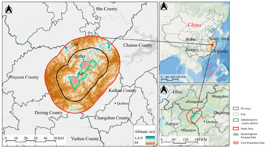
In Luoyuan Bay, China, Sporobolus alterniflorus invasion has hindered mangrove restoration and disrupted faunal communities within mangrove habitats. This study investigated its impact on mollusk, crab, and fish assemblages across mangrove, mudflat, and invaded habitats from 2019 to 2020. Results showed that species
[...] Read more.
In Luoyuan Bay, China, Sporobolus alterniflorus invasion has hindered mangrove restoration and disrupted faunal communities within mangrove habitats. This study investigated its impact on mollusk, crab, and fish assemblages across mangrove, mudflat, and invaded habitats from 2019 to 2020. Results showed that species diversity of three assemblages did not differ significantly between invaded and non-invaded mangrove habitats; however, assemblage structure was altered and functional traits declined markedly in invaded areas. Compared with non-invaded mangroves, invaded habitats showed decreases of 81.6% in mollusk density, 50.7% in mollusk biomass, 66.6% in crab density and 84.2% in crab biomass. Dominant fish species (Acanthogobius ommaturus, Liza carinata, Stolephorus chinensis) also exhibited lower body size, total size and biomass in invaded habitats. Given the close dependence of coastal residents on these faunal resources, a socioeconomic analysis of livelihood strategies was conducted, revealing Sinonovacula constricta aquaculture achieved the highest net income-to-investment ratio, 122.7% higher than nearshore fishery and 308.3% higher than shallow-sea oyster cultivation, while professional shellfish farming yielded the highest net income per hectare, 23.6% higher than oyster cultivation. Thus, both forms of shellfish aquaculture provide greater economic returns than other livelihood options. Based on these findings and niche theory, we propose a management framework: after removing S. alterniflorus, plant native mangroves (Kandelia obovata) in mid-to-high intertidal zones and lease lower flats for shellfish farming. This framework has the potential to integrate ecological restoration with local livelihoods and may inform similar efforts in other regions facing biological invasions and restoration challenges.
Full article
(This article belongs to the Section Land, Biodiversity, and Human Wellbeing)
►
Show Figures

Figure 1


