



Next Issue
Volume 18, September-1
Previous Issue
Volume 18, August-1
 
 
water-logo

Journal Browser

Journal Browser

Water, Volume 18, Issue 16 (August-2 2026) – 134 articles
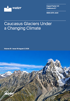
Cover Story (view full-size image): This aerial photograph, captured in September 2024 over Mt. Ushba (4700 m a.s.l.) and Guli Glacier in the Georgian Caucasus, illustrates a high-mountain environment undergoing pronounced glacial and geomorphic change. The observed landscape reflects persistent glacier mass loss, which has intensified since the early 2000s and is consistent with broader patterns of glacier recession across the Caucasus and other mountain regions in response to climatic warming. Beyond changes in glacier extent and volume, these processes have important implications for downstream hydrology, ecosystem dynamics, and the geomorphic development of glacierized catchments. View this paper
  • Issues are regarded as officially published after their release is announced to the table of contents alert mailing list.
  • You may sign up for e-mail alerts to receive table of contents of newly released issues.
  • PDF is the official format for papers published in both, html and pdf forms. To view the papers in pdf format, click on the "PDF Full-text" link, and use the free Adobe Reader to open them.
Order results
Result details
Section
Select all
Export citation of selected articles as:
33 pages, 6938 KB  
Article
Configurational Pathways for Improving Marine Environmental Governance Efficiency in the Digital Era: A Two-Stage Network SBM and fsQCA Analysis
by Yi Zhang, Yingchao Nie, Zhihui Zhao and Zhenshun Tu
Water 2026, 18(16), 2058; https://doi.org/10.3390/w18162058 - 21 Aug 2026
Viewed by 312
Abstract
With the backdrop of the coexistence of sustainable development of marine economy and ecological environment restrictions, how to enhance the efficiency of marine environmental governance (MEGE) has become a significant topic whereby coastal regions should attain green transformation. The research object in this [...] Read more.
With the backdrop of the coexistence of sustainable development of marine economy and ecological environment restrictions, how to enhance the efficiency of marine environmental governance (MEGE) has become a significant topic whereby coastal regions should attain green transformation. The research object in this paper is 11 coastal provincial administrative units in mainland China between 2013 and 2021, and marine environmental governance is divided into two stages of production and governance. MEGE and its stage efficiency are measured with the help of the two-stage super-efficiency Network SBM model, and the efficiency growth is characterized with the help of the Network Malmquist index. It is on this basis that, using the technology–organization–environment (TOE) framework, six antecedent conditions of digital economy, technological innovation, marine industrial structure, marine industrial agglomeration, environmental regulation, and degree of openness are chosen and fsQCA is applied to determine the multiple configuration paths of high MEGE growth. The findings indicate the following: (1) The MEGE in the coastal regions of China is improving in general, although the differences in the region remain evident. The efficiency characteristics of the production stage and the governance stage differ, and the inter-provincial differentiation of the governance stage is more pronounced. (2) No single condition is required to achieve high MEGE growth but four equifinal configurations created by the combined action of several conditions can be further reduced to three types, namely technology–environment driven, technology–organization–environment synergistic and technology–organization driven. (3) There exists apparent synergy, compensation, and substitution relationships between technology, organization, and environmental conditions. The most important aspect of high-efficiency growth is not that all positive conditions are on a high level simultaneously, but that a complex of conditions corresponding to the foundation of regional development is created. (4) High and non-high MEGE growth have a strong causal asymmetry and the effective driving routes in various regions are also different. This paper extends the study of the efficiency of marine environmental governance in the two dimensions of internal stage structure and configuration mechanism, and applies accurate, path adaptation, and regional differentiation governance to coastal regions. Full article
Show Figures

Graphical abstract

16 pages, 1985 KB  
Article
Global–Local Divergence in Technological Innovation: A Dual-Database Bibliometric Analysis of Dissolved Organic Matter–Heavy Metal Interactions (2004–2024)
by Junxi Luo, Yuan Wang, Lan Zhang, Baocheng Zhao, Zhenghui Fu and Zheng Li
Water 2026, 18(16), 2057; https://doi.org/10.3390/w18162057 - 21 Aug 2026
Viewed by 332
Abstract
Conventional heavy metal remediation technologies are constrained by low efficiency, secondary pollution risks, and limited scalability. Dissolved organic matter (DOM), with its green, cost-effective complexation properties, has become a promising pathway for pollution control. Existing patent bibliometric studies in this field suffer from [...] Read more.
Conventional heavy metal remediation technologies are constrained by low efficiency, secondary pollution risks, and limited scalability. Dissolved organic matter (DOM), with its green, cost-effective complexation properties, has become a promising pathway for pollution control. Existing patent bibliometric studies in this field suffer from single-database bias, limited causal quantification of policy impacts, and incomplete depiction of global–local technological heterogeneity. To address these gaps, this study maps the technological innovation landscape of DOM interactions with four typical heavy metals (Cd, Pb, Cu, Zn) during 2004–2024, using a complementary dual-database framework combining Derwent and IncoPat. We integrate a three-dimensional “time–region–technology” analytical framework with interrupted time series analysis (ITSA), after standardized data processing including family deduplication and citation normalization. Cross-validation confirms that China contributes the largest share of global patent output (46.6% in Derwent, 55.0% in IncoPat). Three milestone environmental policies in China exert sequentially intensifying causal effects on patent growth (all p < 0.05), forming a closed-loop mechanism of policy orientation, funding support, technology transfer, and international diffusion. We identify a pronounced global–local technological divergence: global frontier innovation centers on digital basic research, whereas local innovation in China prioritizes engineering applications. Core patents advance the field through cross-domain technology adaptation, and the representative technical paradigm (exemplified by patent CN101168852A) has been industrially validated. These findings provide empirical support for engineering translation and policy optimization in DOM-based heavy metal remediation. Full article
(This article belongs to the Special Issue Advances in Plateau Lake Water Quality and Eutrophication)
Show Figures

Figure 1

20 pages, 18912 KB  
Article
Analysis of the Effects of Mixed-Flow Pump Inlet Structure on Pressure Pulsations and Energy Transport Characteristics
by Guangyao Wu, Yongliang Xu, Xiaolin Shao, Yongxin Jin and Junlian Yin
Water 2026, 18(16), 2056; https://doi.org/10.3390/w18162056 - 21 Aug 2026
Viewed by 238
Abstract
To investigate the influence of inlet structure optimization on pressure pulsation and energy transport characteristics in mixed-flow pumps, this study employed experimental and numerical calculation methods to analyze both original and optimized models. The SST-SAS turbulence model was selected for flow field computation. [...] Read more.
To investigate the influence of inlet structure optimization on pressure pulsation and energy transport characteristics in mixed-flow pumps, this study employed experimental and numerical calculation methods to analyze both original and optimized models. The SST-SAS turbulence model was selected for flow field computation. The experimental and numerical results showed that inlet optimization increased the head at the design condition by 1.52 m, improved the efficiency by 5.38%, and reduced the pressure pulsation amplitude by more than 90%. Analysis of energy transport term distribution characteristics within the pump revealed the mechanism behind pulsation intensity improvement: the pressure propulsion power distribution in the impeller became more stable, while the Lamb vector divergence dissipation regions and enstrophy dissipation regions substantially decreased, thereby increasing the proportion of pressure propulsion power contribution. The enhanced energy transport characteristics and improved flow field stability in the impeller region collectively optimized energy conversion performance within the impeller. Full article
(This article belongs to the Section Hydraulics and Hydrodynamics)
Show Figures

Figure 1

41 pages, 11502 KB  
Article
Explainable Deep Ensemble Bias Correction of GloFAS-ERA5 Streamflow Across Snow-Influenced Transboundary Basins of Central Asia
by Tetyana Honcharenko, Serhii Dolhopolov, Alexandr Neftissov, Ilyas Kazambayev, Aliya Aubakirova, Lalita Kirichenko and Oleksandr Kuchanskyi
Water 2026, 18(16), 2055; https://doi.org/10.3390/w18162055 - 21 Aug 2026
Viewed by 476
Abstract
Global streamflow reanalyses such as GloFAS-ERA5 are available everywhere yet lose fidelity in small, snow- and glacier-fed headwaters that feed Central Asia’s transboundary rivers. We present an explainable, calibrated deep ensemble framework that corrects the GloFAS-ERA5 log-residual at gauges of the Syr Darya [...] Read more.
Global streamflow reanalyses such as GloFAS-ERA5 are available everywhere yet lose fidelity in small, snow- and glacier-fed headwaters that feed Central Asia’s transboundary rivers. We present an explainable, calibrated deep ensemble framework that corrects the GloFAS-ERA5 log-residual at gauges of the Syr Darya and Amu Darya systems using the CA-discharge archive. An entity-aware long short-term memory (LSTM) backbone drives a regime-gated mixture of experts trained under a closed-form mixture continuous ranked probability score (CRPS) and augmented with snow physics constraints and a regime-conditional (Mondrian) conformal layer; skill was assessed under temporal holdout, leave-one-basin-out and prediction in ungauged region protocols, with grouped Shapley value attribution. Correction rendered all 74 gauges skillful, raising the median modified Kling–Gupta efficiency (KGE′) from 0.386 (raw) to 0.825 (flagship); on temporal point skill the framework is statistically tied with gradient boosting (paired Wilcoxon p = 0.49). Under-dispersed raw intervals (90% coverage 0.68) were recalibrated to near-nominal coverage (~0.90), and high-flow exceedance decision skill was moderate (Q90 Brier skill score 0.34, ROC-AUC 0.92), while low-flow (Q10) exceedance showed no skill over climatology. Transfer to ungauged, more glacierized catchments was a measured limit that degraded with glacier fraction and basin area. The framework’s value is calibration, an inspectable (supervised) regime structure and regional physical insight, not point skill superiority. Full article
Show Figures

Figure 1

15 pages, 3046 KB  
Article
Research on the Ecosystem Service Value of the Xiaolangdi Reservoir Area Using the Value Equivalence Method
by Jie Li, Wei Wang, Liu Sun, Yawei Hu, Rongxu Chen and David Benson
Water 2026, 18(16), 2054; https://doi.org/10.3390/w18162054 - 21 Aug 2026
Viewed by 332
Abstract
Land-use transformation driven by large-scale water conservancy projects profoundly reshapes regional ecosystem structures and the supply capacity of ecosystem services, yet targeted quantitative assessments linking land-use evolution to ecosystem service values (ESV) in the Xiaolangdi Reservoir resettlement zone remain insufficient, restricting scientific ecological [...] Read more.
Land-use transformation driven by large-scale water conservancy projects profoundly reshapes regional ecosystem structures and the supply capacity of ecosystem services, yet targeted quantitative assessments linking land-use evolution to ecosystem service values (ESV) in the Xiaolangdi Reservoir resettlement zone remain insufficient, restricting scientific ecological management and territorial spatial governance for reservoir-affected counties and districts. This study draws on the latest ecosystem service valuation theories proposed by domestic and international scholars and applies the value equivalence method to quantify variations in land-use pattern changes and ESV across nine resettlement counties and districts (including the Sanmenxia urban area) affected by the Xiaolangdi Reservoir relocation project. Data collected included historical records (1995–2020), digital elevation models (DEM, 30 m resolution), and land-use information. By applying value equivalence theory and analyzing land-use change impacts, the study calculated changes in ESV and conducted sensitivity analyses across different land types. The findings reveal significant impacts on surrounding counties following the reservoir’s completion. Data indicate that the expansion of water areas drove the total ESV to rise from US$3.3261 billion in 1995 to a peak of US$3.6557 billion in 2010, followed by a decline to US$3.6128 billion in 2020. The most pronounced changes occurred during the first five years post-reservoir filling (2000–2005), marked by elevated water sensitivity indices. This research clarifies the differentiated responses of ecosystem service functions to land-use changes across reservoir-affected counties, provides quantitative decision-making support for coordinated ecological restoration, cultivated land protection, and sustainable land management in the resettlement area of the Xiaolangdi Reservoir, and offers a replicable technical framework for ecosystem service valuation of large sediment-laden river reservoir regions worldwide. Full article
Show Figures

Figure 1

20 pages, 12303 KB  
Article
Sensitivity Analysis and Calibration of the SWAN Model for Simulating Typhoon Doksuri Waves Along the Fujian Coast: Implications for Economic Decision Costs
by Tong Li, Hongkun Lin and Cheng Chen
Water 2026, 18(16), 2053; https://doi.org/10.3390/w18162053 - 21 Aug 2026
Viewed by 325
Abstract
This paper evaluates the sensitivity and calibration of the third-generation shallow-water wave model SWAN for Typhoon Doksuri (No. 202305) along the Fujian coast. Sensitivity analyses were conducted for model initialization, wind forcing, and key physical parameters. The results show that a 1-day spin-up [...] Read more.
This paper evaluates the sensitivity and calibration of the third-generation shallow-water wave model SWAN for Typhoon Doksuri (No. 202305) along the Fujian coast. Sensitivity analyses were conducted for model initialization, wind forcing, and key physical parameters. The results show that a 1-day spin-up period is sufficient to largely reduce the initial error caused by a cold start. A locally refined unstructured triangular grid was adopted, and ERA5 reanalysis winds were blended with the Holland empirical typhoon wind field to better represent extreme winds near the typhoon core. Further tests indicate that the combination of the Janssen wind input scheme, cds1 = 3.5, LTA triad wave interaction scheme, JONSWAP bottom friction scheme, and a wave-breaking parameter of 0.73 can effectively reproduce the typhoon wave process along the Fujian coast. The optimized simulations agree well with buoy observations and provide a reference for typhoon wave forecasting and coastal disaster risk assessment. Full article
Show Figures

Figure 1

16 pages, 15997 KB  
Article
Charging, Generation, and PID Control-Activation Characteristics of a One-Pipe–Two-Unit Hydraulic Short-Circuit Pumped-Storage System: A Simulation Case Study
by Fei Zhang, Jing Fu, Faye Jin and Xueli An
Water 2026, 18(16), 2052; https://doi.org/10.3390/w18162052 - 21 Aug 2026
Viewed by 459
Abstract
To address the limited pumping-mode flexibility of fixed-speed pumped-storage units, this paper presents a simulation case study of a one-pipe–two-unit parallel ternary system developed in OpenModelica and coupled with Python 3.7. The study examines pure charging and generation, hydraulic short-circuit (HSC) charging, and [...] Read more.
To address the limited pumping-mode flexibility of fixed-speed pumped-storage units, this paper presents a simulation case study of a one-pipe–two-unit parallel ternary system developed in OpenModelica and coupled with Python 3.7. The study examines pure charging and generation, hydraulic short-circuit (HSC) charging, and the PID control-activation transient at nominal speed. A 50 MW benchmark reproduces published pump and turbine shaft powers to within approximately 0.5%, while the system-efficiency difference is 0.14 percentage points, supporting implementation consistency; no plant-measurement validation is claimed. Dual-pump operation reduces the charging time by approximately 44% relative to single-pump operation but lowers efficiency, whereas dual-turbine operation is slightly more efficient because of improved per-unit flow matching. Across the full-cycle HSC sweep, average efficiency increases from 38.6% at 40 MW to 74.1% at 90 MW as internal recirculation decreases. In the PID sensitivity screen, the proportional gain k has the largest effect on the response, a small integral time Ti amplifies sensitivity to k and can increase overshoot or hydraulic loading, and the derivative coefficient wd has only a minor effect within the tested range. The numerical bounds are specific to the selected characteristic maps, reservoir, and waterway; the results are intended as retrofit-screening guidance rather than universal design limits. Full article
Show Figures

Figure 1

21 pages, 8588 KB  
Article
Assessing Water-Governance Fragility in a Water-Scarce Agricultural Area of Northern Mexico
by Gabriel López Porras, Gilberto Sandino-Aquino de Los Ríos, Leonor Cortés-Palacios and Lauro Manuel Espino Enríquez
Water 2026, 18(16), 2051; https://doi.org/10.3390/w18162051 - 21 Aug 2026
Viewed by 539
Abstract
Freshwater scarcity can weaken water governance when hydrological pressure interacts with intensive agricultural demand, regulatory weakness, and political conflict. This research evaluates whether Irrigation District 005 (IR 005) in Chihuahua, northern Mexico, demonstrates local water-governance fragility across three domains: public security, the rule [...] Read more.
Freshwater scarcity can weaken water governance when hydrological pressure interacts with intensive agricultural demand, regulatory weakness, and political conflict. This research evaluates whether Irrigation District 005 (IR 005) in Chihuahua, northern Mexico, demonstrates local water-governance fragility across three domains: public security, the rule of law, and the ability to sustain water access and food production. A mixed-methods approach integrates legal and human rights documentation, institutional records, published studies, and a structured media review with hydrological, agricultural, climatic, and reservoir data. Water balances were analysed for 1998–2023, precipitation trends for 1980–2020, and crop water requirements were estimated using the Food and Agriculture Organization’s Irrigation and Drainage Paper No. 56 (FAO-56) Penman–Monteith framework, the crop coefficient (Kc), the water-stress coefficient (Ks), the United States Soil Conservation Service (SCS) Curve Number method, and application-efficiency assumptions. The 2020 water conflict resulted in fatalities, injuries, arrests, and documented human rights violations. Rule-of-law capacity was further diminished by unauthorised withdrawals, cultivation beyond authorised irrigation plans, and limited enforcement. The annual water balance shifted to persistent deficits after 2016, reaching an estimated deficit of 2268 cubic hectometres (hm3) in 2020. Annual precipitation did not exhibit a statistically significant monotonic decline during 1980–2020 (Mann–Kendall Z = −0.79, τ = −0.0878, p = 0.4251; Sen’s slope = −1.1628 mm yr−1; Mann–Whitney p = 0.5313), indicating that recent stress is more closely linked to production scale, crop mix, governance conditions, and irrigation efficiency than to a long-term reduction in rainfall. Sensitivity analysis revealed that ±15% changes in Kc and Ks altered gross water requirements by approximately ±16–17%, while equivalent changes in effective precipitation produced changes of only 1–3%. These results demonstrate heightened water-governance fragility resulting from mutually reinforcing hydrological, institutional, and conflict-related pressures. Future research should refine locally calibrated water-demand parameters and develop reproducible monitoring systems that combine hydrological, institutional, satellite, and participatory data to support anticipatory, transparent, and rights-based water governance. Full article
(This article belongs to the Section Water Use and Scarcity)
Show Figures

Figure 1

34 pages, 6523 KB  
Article
Multidimensional Assessment of Hydroclimatic Changes in Northern Cyprus
by Hasan Zaifoglu
Water 2026, 18(16), 2050; https://doi.org/10.3390/w18162050 - 21 Aug 2026
Viewed by 350
Abstract
Climate change is driving hydroclimatic changes that are not fully captured by conventional trend analyses. This study presents a multidimensional assessment of hydroclimatic changes in Northern Cyprus using observational records from 27 precipitation stations and 12 temperature stations, with precipitation records spanning 35–46 [...] Read more.
Climate change is driving hydroclimatic changes that are not fully captured by conventional trend analyses. This study presents a multidimensional assessment of hydroclimatic changes in Northern Cyprus using observational records from 27 precipitation stations and 12 temperature stations, with precipitation records spanning 35–46 years and temperature records spanning 21–30 years. Modified Mann–Kendall (MMK), Pettitt (PT), Innovative Trend Analysis (ITA), and Structural Trend and Variability Identification (STVI) methods were integrated to examine monotonic trends, abrupt shifts, distribution-dependent changes, and mean–variability interactions at annual and seasonal scales. Results revealed pronounced spatial heterogeneity and seasonal asymmetry in precipitation totals and their temporal evolution. Increasing tendencies were mainly concentrated in the Kyrenia mountainous region and parts of the western coast, whereas several eastern coastal stations showed drying tendencies, particularly in spring. Winter exhibited the most coherent wetting signal, while spring was more fragmented and drying-dominated. Monthly mean of daily maximum temperature (Tmax) and monthly mean of daily minimum temperature (Tmin) generally showed widespread warming, although Tmin responses were more localized and season-dependent. ITA indicated asymmetric precipitation behavior, with medium and high precipitation values generally increasing, while low values often decreased or showed mixed responses. STVI further revealed that precipitation changes involved substantial restructuring of both mean and variability components, whereas temperature changes were mainly mean-driven. The findings provide a more comprehensive understanding of evolving hydroclimatic conditions, which can support climate adaptation and water resources management in semi-arid Mediterranean regions. Full article
(This article belongs to the Section Hydrology)
Show Figures

Figure 1

30 pages, 13098 KB  
Article
A Study on Seepage Pressure Forecasting for Concrete Dams Based on Multi-Scale Preprocessing and Dual-Model Integration
by Yutian Zhang, Tao Xu, Yantao Zhu, Shangfa Chen and Haoran Wang
Water 2026, 18(16), 2049; https://doi.org/10.3390/w18162049 - 20 Aug 2026
Viewed by 324
Abstract
Seepage pressure time series of concrete dams are governed by reservoir water level, rainfall, temperature and long-term aging effects, featured by strong nonstationarity and complex multi-scale fluctuations. Existing decomposition–ensemble methods ignore nonlinear coupling among scale components, suffering low prediction accuracy and poor physical [...] Read more.
Seepage pressure time series of concrete dams are governed by reservoir water level, rainfall, temperature and long-term aging effects, featured by strong nonstationarity and complex multi-scale fluctuations. Existing decomposition–ensemble methods ignore nonlinear coupling among scale components, suffering low prediction accuracy and poor physical interpretability. Current model fusion schemes fail to adapt to differentiated evolution mechanisms of frequency-varying seepage components and cannot fully mine implicit cross-scale nonlinear correlations. To overcome these drawbacks, this study proposes a concrete dam seepage pressure prediction approach integrating ensemble empirical mode decomposition, multi-scale preprocessing, and optimized dual-model selection combining ridge regression and Transformer–BiLSTM. Ensemble empirical mode decomposition adaptively denoises and decouples raw seepage series into high-, medium- and low-frequency IMFs according to oscillation cycles. A normalized Comprehensive Optimization Index is constructed to parallelly train ridge regression and Transformer–BiLSTM for each component and select the optimal submodel dynamically. A fully connected nonlinear fusion layer reconstructs multi-scale predictions to retain inherent component coupling features, replacing traditional simple linear superposition. Engineering cases verify that the proposed model efficiently captures periodic laws of key influencing factors, significantly boosting prediction accuracy and generalization capacity, thus possessing prominent theoretical and practical engineering application values. Full article
Show Figures

Figure 1

35 pages, 5537 KB  
Article
Accuracy–Cost–Robustness Trade-Offs in Rigid Water Column Model-Trained Machine Learning Surrogates for Transient Leakage Prediction During Pressure-Reducing Valve Manoeuvres
by Alex J. Garzón-Orduña, Modesto Pérez-Sánchez and Oscar E. Coronado-Hernández
Water 2026, 18(16), 2048; https://doi.org/10.3390/w18162048 - 20 Aug 2026
Viewed by 527
Abstract
Rapid leakage prediction during pressure-reducing valve manoeuvres requires models that reproduce inertial hydraulic effects at low computational cost. This study proposes a reproducible surrogate-modelling framework in which transient leakage responses are generated with an extended rigid water column model incorporating time-dependent valve resistance [...] Read more.
Rapid leakage prediction during pressure-reducing valve manoeuvres requires models that reproduce inertial hydraulic effects at low computational cost. This study proposes a reproducible surrogate-modelling framework in which transient leakage responses are generated with an extended rigid water column model incorporating time-dependent valve resistance and then used to train machine learning regressors. Twenty-eight regression models were evaluated using four SCADA-oriented predictors: time, inlet flow, upstream pressure head, and valve position. Model selection followed an accuracy–cost–predictive-stability assessment that considered predictive error, training time, inference speed, model size, and behaviour under near-domain, boundary-unseen, and extreme extrapolation scenarios. Gaussian process regression achieved the lowest in-domain errors, with test root mean square error values of 0.0017–0.0019 L/s, but required training times above 21,000 s and inference speeds below 700 observations/s. Bagged Trees provided the most balanced option for PRV-operation screening within the represented hydraulic domain, combining low prediction error, high inference capacity, and stable behaviour within the evaluated near-domain and boundary-unseen range. The P3 extrapolation test showed that prediction beyond the represented hydraulic envelope requires scenario-library expansion and model reassessment. The framework supports rapid valve-operation screening and numerical assessment of RWCM-generated transient leakage responses, while field or SCADA-supported use requires local calibration and validation. Full article
(This article belongs to the Special Issue Digital Innovations in Integrated Water Resources Management)
Show Figures

Figure 1

18 pages, 5007 KB  
Article
A Framework for Evaluating Meteorological Drought Indices as Indicators of Low Flows: A Case Study of the Biała Lądecka River Catchment Area
by Teresa Jakubczyk and Jacek Leśny
Water 2026, 18(16), 2047; https://doi.org/10.3390/w18162047 - 20 Aug 2026
Viewed by 405
Abstract
Meteorological, soil, and hydrological droughts are among the most important phenomena affecting the natural environment and water management. Prolonged precipitation deficits often result in low river flows, reducing water resources and degrading aquatic ecosystems. This study evaluates the potential of meteorological drought indices [...] Read more.
Meteorological, soil, and hydrological droughts are among the most important phenomena affecting the natural environment and water management. Prolonged precipitation deficits often result in low river flows, reducing water resources and degrading aquatic ecosystems. This study evaluates the potential of meteorological drought indices as predictors of observed low flows. Long-term meteorological and hydrological data, including precipitation and river discharge records, were analyzed for the Biała Lądecka River catchment in Lower Silesia, southwestern Poland. Meteorological drought was characterized using the Standardized Precipitation Index (SPI) and the Standardized Precipitation Evapotranspiration Index (SPEI) calculated for 1-, 3-, and 6-month timescales, together with corresponding one- and two-week indices. Relationships between drought index values and observed low flows were analyzed while accounting for the time lag of the catchment response. The predictive performance of individual indices was evaluated to determine their suitability for water resource monitoring and management. The results show that meteorological drought indices can effectively indicate the occurrence of low flows, although the strength of the relationships depends on the adopted timescale. Both classical and short-term indices proved useful for analyzing the development of hydrological drought and have potential applications in low-flow monitoring and early warning systems. Full article
(This article belongs to the Section Hydrology)
Show Figures

Figure 1

19 pages, 23971 KB  
Article
Evaluation and Prediction of the Thermal Melting Stability of Permafrost in the Source Region of Datong River Based on Geomorphic Classification
by Shengting Wang, Wenqi Gao and Xubin Huang
Water 2026, 18(16), 2046; https://doi.org/10.3390/w18162046 - 20 Aug 2026
Viewed by 272
Abstract
With the ongoing intensification of climate warming and human activities, the permafrost on the Qinghai–Tibet Plateau has exhibited a degradation trend characterized by rising ground temperatures and thickening active layers over the years. Particularly in ice-rich permafrost regions, thermal melting disasters, such as [...] Read more.
With the ongoing intensification of climate warming and human activities, the permafrost on the Qinghai–Tibet Plateau has exhibited a degradation trend characterized by rising ground temperatures and thickening active layers over the years. Particularly in ice-rich permafrost regions, thermal melting disasters, such as ground subsidence caused by thermal melting, pose a significant threat to infrastructure in permafrost areas. Based on monitoring data from the source region of the Datong River, this article developed a calculation model for active layer thickness (ALT) based on underlying surface types. Utilizing an underground ice distribution model established through geomorphic classification and lithological characteristics, in conjunction with the Nelson model, a risk evaluation of thermal melting disasters in the source region of Datong River was conducted. Based on the current warming trend, the future variation trend of ALT was predicted, and thermal stability was evaluated. The results indicated that ALT in the source region ranged from 1.0 to 3.5 m, with a close correlation between ALT and underlying surface types. The overall thermal stability of the source region is relatively satisfactory, yet it is inadequate in high-altitude areas and on bare ground. Compared to bare ground, swamp meadows and alpine meadows offer superior protective effects on the thermal stability of permafrost in the source region. Full article
(This article belongs to the Section Soil and Water)
Show Figures

Figure 1

19 pages, 7250 KB  
Article
Inactivation of Heterosigma akashiwo in Marine Water by UV-Activated Periodate: Efficacy and Mechanism
by Yuanxun Cheng, Pin Gan, Xuan Chen and Yuanyuan Zhang
Water 2026, 18(16), 2045; https://doi.org/10.3390/w18162045 - 20 Aug 2026
Viewed by 269
Abstract
The combination of ultraviolet (UV) and periodate (PI) is a promising advanced oxidation process. We investigated the inactivation of a typical harmful algae species, Heterosigma akashiwo by UV/PI treatment and explored the inactivation mechanism at the cellular and molecular levels. The inactivation efficacy [...] Read more.
The combination of ultraviolet (UV) and periodate (PI) is a promising advanced oxidation process. We investigated the inactivation of a typical harmful algae species, Heterosigma akashiwo by UV/PI treatment and explored the inactivation mechanism at the cellular and molecular levels. The inactivation efficacy of H. akashiwo by UV/PI and UV treatment alone was 9.21-ln and 1.23-ln within 37.5 min, respectively. Hydroxyl radicals (•OH) and singlet oxygen (1O2) contributed to H. akashiwo inactivation in the UV/PI system. Obvious destruction of the cell structure observed by transmission electron microscopy and the increases in extracellular DNA levels indicated membrane damage by the reactive species. The activity changes in the antioxidant enzymes and the decreases in ATP contents of H. akashiwo after UV/PI treatment were both more severe than that after UV treatment. The results indicated that the antioxidant defense system and the mitochondria of H. akashiwo cells were disrupted. The photosynthesis was also affected as both of the chlorophyll-a content and the maximum dark-adapted photochemical efficiency (Fv/Fm) of H. akashiwo decreased obviously. The transcriptomics analysis proved that UV/PI treatment caused abnormal energy metabolism and cell function. Moreover, the down regulation of gene expression enriched in the phagocytic pathway indicated that the cell was severely damaged and inactivated under oxidative stress. Full article
(This article belongs to the Special Issue The Oxidation and Disinfection Processes in Water Treatment)
Show Figures

Graphical abstract

24 pages, 8668 KB  
Article
Research on Precise Leakage Localization Technology in Water Supply Networks Based on Surface Array Sampling
by Wanhao Lin, Chengling Bai, Zhigang Liu, Lili Zhou, Yiyuan Zhu, Peng Wang and Tingchao Yu
Water 2026, 18(16), 2044; https://doi.org/10.3390/w18162044 - 20 Aug 2026
Viewed by 284
Abstract
Water leakage in water supply pipeline networks leads to water resource loss, drinking water contamination, and ground subsidence. The existing acoustic leak detection techniques are constrained by low signal-to-noise ratios of leakage signals, difficulties in wave velocity estimation, and rapid signal attenuation, often [...] Read more.
Water leakage in water supply pipeline networks leads to water resource loss, drinking water contamination, and ground subsidence. The existing acoustic leak detection techniques are constrained by low signal-to-noise ratios of leakage signals, difficulties in wave velocity estimation, and rapid signal attenuation, often resulting in localization errors of several meters. This study proposes a “wavenumber–frequency spectrum filtering and phase analysis” method for leak source localization, achieving precise positioning of underground water pipeline leaks through surface-mounted sensor array sampling. Based on the numerical simulation results, this research reveals the wavenumber–frequency spectrum characteristics of leakage noise on the ground surface, analyzes the impact of the sampling strategies on the wavenumber extraction, and ultimately constructs a localization model suitable for near-field array sampling. A mean localization error of 0.0374 m was achieved in a controlled experiment under single-layer sandy soil conditions, demonstrating the feasibility and accuracy of the proposed method under these tested conditions and providing a promising basis for precise leak localization in water supply networks that warrants further field validation. Full article
Show Figures

Figure 1

21 pages, 2567 KB  
Article
Seasonal Water Quality, Trace Element Concentrations, and Estuarine Salinity Dynamics in Two Urban Rivers of Panama with Contrasting Urbanization Levels
by Paul Schalin, Gabriela Mock, Kathia Broce and Gisselle Guerra-Chanis
Water 2026, 18(16), 2043; https://doi.org/10.3390/w18162043 - 20 Aug 2026
Viewed by 351
Abstract
Urban rivers face increasing degradation from wastewater, runoff, and land-use change, yet multi-season tropical estuarine datasets remain scarce. This study compared physicochemical water quality, metals, and salinity dynamics over one year in the Juan Díaz and Pacora rivers, two contrastingly urbanized Panama Bay [...] Read more.
Urban rivers face increasing degradation from wastewater, runoff, and land-use change, yet multi-season tropical estuarine datasets remain scarce. This study compared physicochemical water quality, metals, and salinity dynamics over one year in the Juan Díaz and Pacora rivers, two contrastingly urbanized Panama Bay watersheds. Juan Díaz showed higher nutrient concentrations, lower dissolved oxygen, and greater variability than Pacora. Dissolved oxygen in Juan Díaz fell below 5 mg/L in five of nine campaigns and ammonia nitrogen exceeded 3.7 mg/L in all three dry-season campaigns, versus two of seven campaigns below 5 mg/L in Pacora. Total dissolved solids exceeded 500 mg/L in four of nine Juan Díaz campaigns, all in the wet season, but stayed compliant in Pacora. Total nitrogen and total phosphorus were up to 10-fold and seven-fold higher, respectively, in Juan Díaz during the dry season. Cu exceeded its USEPA criterion in two of three detections; Cd was detected once, in Juan Díaz, below its saltwater criterion (0.0079 mg/L). Salinity confirmed stronger tidal influence in Juan Díaz (up to 24.7 g/kg) than Pacora (0.03–2.74 g/kg). PCA separated the two rivers along a nutrient–oxygen gradient explaining 53.6% of variance. Overall, Juan Díaz shows greater degradation, while Pacora remains less contaminated but requires continued monitoring amid rapid urbanization. Full article
(This article belongs to the Section Water Quality and Contamination)
Show Figures

Figure 1

29 pages, 13055 KB  
Article
Quantifying Future Drought Intensity and Frequency: A Multi-Scenario Study Using SPI, PDSI, and LPDF in the Mid-Atlantic Region of the US
by Majid Mirzaei, Adel Shirmohammadi, Paul T. Leisnham and Puneet Srivastava
Water 2026, 18(16), 2042; https://doi.org/10.3390/w18162042 - 20 Aug 2026
Viewed by 345
Abstract
Drought is a natural hazard characterized by gradual onset and prolonged precipitation deficit. With climate change intensifying precipitation variability, accurate drought assessment is critical for effective water resource management and mitigation. Focusing on Maryland in the Mid-Atlantic region of the United States, this [...] Read more.
Drought is a natural hazard characterized by gradual onset and prolonged precipitation deficit. With climate change intensifying precipitation variability, accurate drought assessment is critical for effective water resource management and mitigation. Focusing on Maryland in the Mid-Atlantic region of the United States, this study computes and analyzes drought indices to assess both near (2021–2060) and late (2061–2100) drought conditions, in the context of climate variability. We employed three distinct objectives to enhance drought assessment and monitoring capabilities under projected climate scenarios: (1) calculation of the Standardized Precipitation Index (SPI) reflecting meteorological conditions using precipitation data from seven GCMs across three SSPs for two future periods (2021–2060 and 2061–2100); (2) integration of both precipitation and temperature projections in the Palmer Drought Severity Index (PDSI) (implemented here as a simplified PDSI based on a standardized Z-index) to reflect combined hydrological and thermal influences (i.e., Hydrological indices); and (3) a Low Precipitation Duration–Frequency Analysis (LPDF) as indicator of both meteorological and hydrological conditions to quantify and compare the frequency and severity of low precipitation events across different SSPs. These objectives were achieved by fitting a gamma distribution for SPI and an Extreme Value Type I distribution for LPDF, and applying Z-index (i.e., long-term moisture abnormalities) and weighting factors representing the ratio of precipitation to evapotranspiration. Results reveal notable variability in SPI values, with a general trend toward increased extreme wet conditions, especially under high emission scenarios (i.e., SSP585) in the latter half of the century (2061–2100). Meanwhile, PDSI analysis indicated a subtle shift toward drier conditions despite increases in precipitation, particularly under SSP126 and SSP245, suggesting that temperature rises may offset precipitation gains. In addition, LPDF values indicated a reduced frequency of prolonged low-precipitation events under SSP585 compared to SSP126 and SSP245; this reflects higher total precipitation and should not be interpreted as resilience to drought, since the concurrent rise in temperature-driven evaporative demand can still intensify hydrological and agricultural drought stress. These results highlight the importance of incorporating climatic variables in drought assessments to understand future meteorological and hydrological scenarios under climate change projections. The study can help water resource managers and illustrates how such integrations can enhance our understanding of future drought scenarios under different climate change projections. Full article
(This article belongs to the Special Issue Advances in Extreme Hydrological Events Modeling)
Show Figures

Figure 1

23 pages, 6569 KB  
Article
Performance Assessment of Irrigation Systems and Water Management Practices in Selected Irrigated Schemes in Rwanda
by Sonia Ikundabayo, Jean de Dieu Bazimenyera and Romuald Bagaragaza
Water 2026, 18(16), 2041; https://doi.org/10.3390/w18162041 - 20 Aug 2026
Viewed by 406
Abstract
This study assessed the current status of irrigation systems and water management practices in Rwanda’s irrigated agricultural zones, focusing on the Nasho Government-Funded Irrigation (GFI) scheme in Kirehe District and the Kagitumba Irrigation Scheme in Nyagatare District. A mixed descriptive approach was used, [...] Read more.
This study assessed the current status of irrigation systems and water management practices in Rwanda’s irrigated agricultural zones, focusing on the Nasho Government-Funded Irrigation (GFI) scheme in Kirehe District and the Kagitumba Irrigation Scheme in Nyagatare District. A mixed descriptive approach was used, combining field observations with structured questionnaires administered via KoboToolbox to 224 respondents in Nasho and 188 in Kagitumba. Field observations were used to evaluate the physical condition and functionality of irrigation infrastructure, while questionnaires captured stakeholder perceptions, water management practices, institutional arrangements, and operational challenges. Results show that both irrigation schemes are operational but function below optimal efficiency due to multiple constraints. In Nasho, irrigation performance is primarily affected by sedimentation in canals and reservoirs, pump inefficiencies, and inadequate maintenance practices, resulting in unreliable water delivery. In Kagitumba, despite the use of modern center pivot systems, performance is constrained by pipeline corrosion, pressure losses, sediment-laden water, and uneven water distribution. Across both schemes, more than 80% of respondents reported frequent system failures, while over 95% indicated the absence of formal irrigation scheduling practices. Water management remains largely reactive, with limited preventive maintenance and weak technical capacity among users and institutions. The study concludes that improving irrigation efficiency in Rwanda requires integrated interventions that combine infrastructure rehabilitation, strengthened maintenance systems, improved water governance, and farmer capacity development to enhance sustainable water use and agricultural productivity. Full article
(This article belongs to the Section Water, Agriculture and Aquaculture)
Show Figures

Figure 1

25 pages, 747 KB  
Review
A Theoretical Framework for Reservoir Ecosystem Regimes: Connotation, Conditions, and Transitions
by Mengzhuo Yang, Shimin Tian, Rongxu Chen, Yang Zhang, Jingyi Chang, Jia Jia, Meng Xia and Xuejie Zhai
Water 2026, 18(16), 2040; https://doi.org/10.3390/w18162040 - 20 Aug 2026
Viewed by 381
Abstract
Reservoirs, driven jointly by artificial regulation and natural processes, are semi-artificial complex ecosystems whose equilibrium states affect the water ecological security and management effectiveness of a river basin. Understanding how operational dispatch alters hydrodynamic processes, habitat structures, and biological succession pathways is necessary, [...] Read more.
Reservoirs, driven jointly by artificial regulation and natural processes, are semi-artificial complex ecosystems whose equilibrium states affect the water ecological security and management effectiveness of a river basin. Understanding how operational dispatch alters hydrodynamic processes, habitat structures, and biological succession pathways is necessary, as traditional steady-state theories based on natural lakes struggle to fully explain the responses of reservoir ecosystems. Therefore, this review constructs a theoretical framework for reservoir ecosystem regimes, defining the core connotation of their “conditional metastable state” as the long-term maintenance of physicochemical, biological, and hydro morphological parameters within limits that allow ecosystem functioning under anthropogenic regulation and natural disturbances. It identifies typical characteristics such as habitat reconstruction-driven dynamics, altered ecological resilience, dual threshold effects, and regulation-modified hydrological processes. We propose that reservoir regime shifts can be analyzed from three levels: the evolutionary sequence of the full life cycle, stage transitions during the operational period, and disturbance responses at multiple time scales. Full article
(This article belongs to the Special Issue Advances in River Ecology Research)
Show Figures

Figure 1

30 pages, 8119 KB  
Systematic Review
Process-Based Mechanisms and Lifecycle Mitigation of Clogging in Interlocking Permeable Pavements: Critical Insights for Sustainable Urban Drainage Systems
by Bockarie Samai, Abiy S. Kebede, Carola S. König, Pedro Martin-Moreta and Alalea Kia
Water 2026, 18(16), 2039; https://doi.org/10.3390/w18162039 - 20 Aug 2026
Viewed by 391
Abstract
Interlocking permeable pavements (IPPs) are increasingly adopted within sustainable urban drainage systems to reduce runoff, improve water quality, and strengthen climate-resilient urban infrastructure. However, clogging remains the principal constraint on their long-term hydraulic performance and wider implementation. This review synthesises current evidence on [...] Read more.
Interlocking permeable pavements (IPPs) are increasingly adopted within sustainable urban drainage systems to reduce runoff, improve water quality, and strengthen climate-resilient urban infrastructure. However, clogging remains the principal constraint on their long-term hydraulic performance and wider implementation. This review synthesises current evidence on clogging mechanisms, hydraulic decline, and lifecycle mitigation strategies for permeable interlocking concrete pavements (PICPs), concrete grid pavements (CGPs), and plastic grid pavers (PGPs). The literature is dominated by PICP studies, with CGP and PGP underrepresented, restricting typology-specific assessment. Sediment accumulation within joints, grid openings, bedding layers, and near-surface interfaces is consistently identified as the primary clogging mechanism, while traffic, rainfall-runoff loading, biological processes, pollutant retention, and sediment inputs from adjacent impervious surfaces further influence hydraulic deterioration. The findings indicate that hydraulic performance is influenced not only by pavement age but also by interactions among pavement design, filler or joint material, drainage configuration, construction quality, sediment exposure, monitoring, and maintenance. Effective mitigation therefore requires lifecycle management, encompassing source control, pretreatment, appropriate material selection, construction quality assurance, routine hydraulic monitoring, and timely preventive and restorative maintenance. Future research should prioritise standardised clogging assessment protocols, improved laboratory–field integration, targeted investigation of CGP and PGP, biological and pollutant-linked clogging processes, climate-driven rainfall extremes, and decision-support. Full article
Show Figures

Graphical abstract

18 pages, 49005 KB  
Article
Full-Space Apparent Resistivity Rapid Imaging Based on Point-Source Attenuation Fields for Roof Water-Hazard Monitoring in Coal Mining
by Haiping Yang, Zhenyao Gao and Shengdong Liu
Water 2026, 18(16), 2038; https://doi.org/10.3390/w18162038 - 20 Aug 2026
Viewed by 280
Abstract
Mining disturbances can promote roof separation, fracture propagation, strata collapse, and water-conducting fracture-zone development, increasing roof water-hazard risk. Conventional apparent-resistivity pseudosection imaging is useful for rapid display; however, restricted electrode deployment limits effective coverage and representation of anomaly position and spatial continuity. Time-lapse [...] Read more.
Mining disturbances can promote roof separation, fracture propagation, strata collapse, and water-conducting fracture-zone development, increasing roof water-hazard risk. Conventional apparent-resistivity pseudosection imaging is useful for rapid display; however, restricted electrode deployment limits effective coverage and representation of anomaly position and spatial continuity. Time-lapse resistivity inversion can characterize progressive fracture development, but representation of discontinuous anomalies caused by rupture, fracture connection, or collapse can be affected by inversion model constraints. To address these limitations, this study proposes a full-space apparent-resistivity rapid imaging method based on point-source attenuation fields. Each current electrode is regarded as a point current source, and potential attenuation with distance is used to construct attenuation curves, map responses to target-region grids, fuse multi-source estimates, and extract representative apparent-resistivity values. Numerical simulations and a scaled physical model experiment show that the method improves the spatial continuity of electrical anomaly responses and provides a more direct representation of abrupt electrical changes. Field application indicates that the method can identify mining-related electrical anomalies in roofs and anomalous ranges potentially associated with fracture development. The maximum vertical extent of the electrical anomaly was approximately 37 m, which was broadly consistent with the empirical estimate of approximately 40 m. The proposed approach provides an efficient geoelectrical monitoring tool for roof water-hazard identification and fracture-zone delineation in coal mining. Full article
(This article belongs to the Special Issue Hydrogeophysical Methods and Hydrogeological Models)
Show Figures

Figure 1

37 pages, 14262 KB  
Article
Pluvial Flood Hotspots in Zhengzhou: Resident Complaints, Government Replies, and Field Verification
by Xiran Liu, Jiaqi Xu and Jun Cai
Water 2026, 18(16), 2037; https://doi.org/10.3390/w18162037 - 19 Aug 2026
Viewed by 370
Abstract
Rapid urbanization and extreme rainfall have increased pluvial flood pressure in dense urban areas, yet many drainage problems emerge at microscale interfaces that conventional flood monitoring does not capture well. Focusing on the built-up area of Zhengzhou, this study uses waterlogging complaints from [...] Read more.
Rapid urbanization and extreme rainfall have increased pluvial flood pressure in dense urban areas, yet many drainage problems emerge at microscale interfaces that conventional flood monitoring does not capture well. Focusing on the built-up area of Zhengzhou, this study uses waterlogging complaints from the People’s Daily Online Leadership Message Board to identify resident-perceived flood hotspots. Government replies, field verification, and built-environment indicators are then combined to examine how these sites are described, assigned, and validated. The complaint records reveal recurrent flood pressure at interface settings, including underground-space entrances, residential-compound–road edges, road depressions, and project boundaries. Field checks confirm that several reported hotspots correspond to visible site conditions. Government replies, however, differ in how clearly they recognize local drainage settings and responsibility boundaries. Persistent mismatches are concentrated at sites shared by multiple actors, and project-edge areas where maintenance and construction responsibilities are difficult to separate. Grid-based diagnosis further shows that planning priority is identified more effectively through the overlap of built-environment exposure, observed site pressure, and governance mismatch than through exposure indicators alone. The study treats complaint–reply exchanges as participatory spatial evidence and proposes a diagnostic procedure linking hotspot interfaces, responsibility boundaries, and field verification for pluvial flood planning. Full article
(This article belongs to the Section Water Resources Management, Policy and Governance)
Show Figures

Figure 1

20 pages, 14427 KB  
Article
Attribution of Seasonal and Interannual Turbidity Variations in Lake Sofia (Sofia Region, Madagascar) to Land-Cover and Climate Change
by Sietse O. Los, Jean-Basile Andriambeloson, Laurence A. Rasoamihaingo, Harison Andriambelo, Mark Grindley and Olly van Biervliet
Water 2026, 18(16), 2036; https://doi.org/10.3390/w18162036 - 19 Aug 2026
Viewed by 343
Abstract
Lake Sofia, located in the mountains of northern Madagascar (1100 m a.s.l.), has experienced increased sediment loads over the past century, which have adversely affected its biodiversity and reduced its lifespan. Lake Sofia provides critical ecosystem services and is an important habitat for [...] Read more.
Lake Sofia, located in the mountains of northern Madagascar (1100 m a.s.l.), has experienced increased sediment loads over the past century, which have adversely affected its biodiversity and reduced its lifespan. Lake Sofia provides critical ecosystem services and is an important habitat for threatened species, e.g., the critically endangered Madagascar Pochard (Aythya innotata). Suggested causes of the high sediment load in Lake Sofia are water erosion, wind erosion, and the stirring of mud from the bottom of the lake by recently introduced tilapia (Oreochromis spp.). Using publicly available weather reanalysis, satellite data, land cover data, soil data, and elevation data, we attribute high turbidity levels in Lake Sofia to water erosion, which explains over 90% of the variance in lake turbidity. Wind erosion was not significant, and tilapia did not contribute to sediment influx. Increased precipitation and decreased vegetation cover in agricultural areas contributed most to increased erosion risk, whereas lavaka (erosion gullies) contributed less. Erosion risk over crop lands has increased by 2% annually and is expected to increase further because of climate change and expected increased precipitation intensity. The erosion model identifies areas most at risk to be targeted for interventions, and is applicable to other catchments in Madagascar and elsewhere. Full article
Show Figures

Figure 1

24 pages, 13687 KB  
Article
Transient Fluctuations in Hydraulic Performance and Energy Dissipation in a Tubular-Flow Pump with Highly Twisted Blades
by Fuheng Wang, Weihu Zou, Qiang Pan, Linlin Geng, Desheng Zhang and Weidong Shi
Water 2026, 18(16), 2035; https://doi.org/10.3390/w18162035 - 19 Aug 2026
Viewed by 256
Abstract
Periodic fluctuations in pump head are a common unsteady phenomenon in tubular pumps; however, their underlying energy dissipation mechanism remains insufficiently understood. This study conducted transient numerical simulations on a two-blade tubular-flow pump with highly twisted blades operating at the design flow condition. [...] Read more.
Periodic fluctuations in pump head are a common unsteady phenomenon in tubular pumps; however, their underlying energy dissipation mechanism remains insufficiently understood. This study conducted transient numerical simulations on a two-blade tubular-flow pump with highly twisted blades operating at the design flow condition. Using entropy production theory, the research quantitatively examined Rotor–Stator Interaction (RSI), vortex development, and hydraulic loss characteristics. The findings reveal that turbulent entropy production is the primary contributor to total energy dissipation, while entropy generated by wall friction is minimal. Although the impeller experiences the greatest absolute energy loss, the fluctuations in entropy production within the guide vane are significantly larger. This indicates that the energy loss represented by the entropy production in the guide vane primarily drives the periodic head fluctuations of the pump. High entropy production is concentrated near both the leading and trailing edges of the guide vane, exhibiting a trough-shaped radial distribution influenced by the leading-edge hub vortex and tip leakage vortex. Additionally, the transient changes in entropy production under RSI are governed by the periodic formation and strengthening of the guide vane passage vortex, along with the shedding and breakdown of the wake vortex. Velocity analysis shows that the circumferential movement of the impeller wake continuously modifies the instantaneous inflow conditions at the guide vane’s leading edge, causing periodic changes in the incidence angle that enhance the passage vortex while weakening the wake vortex. This study provides deep insights into the operational stability of pumps and pumping stations in water transfer projects. Full article
Show Figures

Figure 1

24 pages, 12821 KB  
Article
Attenuation of Supercritical CO2 Phase-Change Shock Waves and Critical Safety Distances for Fish: A Combined Experimental–Numerical Study
by Erdi Abi, Jianbo Zhou, Yunjie Pu, Peng Zhang, Deying Tang, Mingwei Liu and Mingjing Jiang
Water 2026, 18(16), 2034; https://doi.org/10.3390/w18162034 - 19 Aug 2026
Viewed by 435
Abstract
This study demonstrates that supercritical carbon dioxide phase-change fracturing technology can reduce acute pressure-related injury potential compared to conventional explosives in underwater reef clearance operations along the Yangtze River. Employing a stepwise “pipe test, numerical simulation and engineering application” framework, a novel rock–water–fish [...] Read more.
This study demonstrates that supercritical carbon dioxide phase-change fracturing technology can reduce acute pressure-related injury potential compared to conventional explosives in underwater reef clearance operations along the Yangtze River. Employing a stepwise “pipe test, numerical simulation and engineering application” framework, a novel rock–water–fish coupled HJC–Gruneisen elastoplastic model was established to simulate cross-medium shock wave attenuation processes. The supercritical CO2 shock wave exhibits characteristics of “low peak overpressure (13% of equivalent explosives) and long duration (6–7 times longer than conventional explosives),” attenuating in water with a power-law index α = 0.717. A dual-parameter “resistance line (intact rock buffer between the fracturing tube and the rock–water interface)–water depth” correction model indicates that the resistance line reduces peak overpressure by 18.6%, while each 10 m increase in water depth enhances attenuation by 60.6%. The preliminary engineering critical safety threshold for 30 cm silver carp (indicated by swim bladder rupture) is 0.20 MPa. Based on the representative engineering scale of the Chaofu Waterway Regulation Project, characterized by water depths of approximately 6–16 m and a resistance-line-controlled buffer condition, a theoretical safety distance model Rsafe was also derived. Under these engineering constraints, the application results indicate that the lethal zone was confined to 7.5–9.9 m, enabling precise lethal-injury-safe zoning. This work establishes a fish injury threshold and safety assessment system for supercritical CO2 subaquatic fracturing, providing direct green guidelines for Yangtze River navigation projects. Full article
(This article belongs to the Section Biodiversity and Functionality of Aquatic Ecosystems)
Show Figures

Figure 1

21 pages, 5089 KB  
Article
The Effectiveness and Durability of the Sequential Application of Iron and Aluminum Coagulants as a Tool for Phosphorus Inactivation in Different Types of Lakes
by Jolanta Katarzyna Grochowska
Water 2026, 18(16), 2033; https://doi.org/10.3390/w18162033 - 19 Aug 2026
Viewed by 333
Abstract
The efficiencies of the restoration of three lakes of varied water dynamics—the polymictic Mielenko Lake (7.8 ha; 1.9 m), the meromictic Klasztorne Małe Lake (13.7 ha; 20.0 m), and the holomictic Klasztorne Duże Lake (57.5 ha; 8.5 m)—with the use of the phosphorus [...] Read more.
The efficiencies of the restoration of three lakes of varied water dynamics—the polymictic Mielenko Lake (7.8 ha; 1.9 m), the meromictic Klasztorne Małe Lake (13.7 ha; 20.0 m), and the holomictic Klasztorne Duże Lake (57.5 ha; 8.5 m)—with the use of the phosphorus inactivation method and with the sequential application of iron and aluminum compounds have been compared. The full dose of the Fe coagulant used for the restoration of these lakes varied between 9 and 93 tons (littoral zone). The full dose of the Al coagulant applied in the studied lakes ranged between 9 and 148 tons (profundal zone). After the application of the reagents, greater efficiency in phosphate removal from the water column was observed in the stratified Klasztorne Małe and Klasztorne Duże lakes. Notably, in both lakes, inhibition of the internal loading process was observed. Research carried out several years after the completion of lake restoration showed that the obtained effects persist quite well in Klasztorne Małe Lake and Klasztorne Duże Lake, and in the case of the shallow-water Mielenko Lake, there was a significant increase in the concentration of phosphorus compounds in the bottom parts of the water. This phenomenon may be related to the shallow depth of the lake, high coupling between water and bottom sediments, and the large surface area of the active bottom. The results obtained for the Klasztorne Lakes show that the use of two types of compounds makes it possible to reduce the cost of restoration, and moreover, the dosing of iron salts in the coastal areas of the lakes ensures a higher level of ecological safety. Full article
(This article belongs to the Section Water Quality and Contamination)
Show Figures

Graphical abstract

27 pages, 25412 KB  
Article
Vegetation–Atmosphere–Land Interactions Driven by Precipitation Extremes in Northeast China
by Fabrice Biot, Bonoua Faye and Bamba Kanvaly
Water 2026, 18(16), 2032; https://doi.org/10.3390/w18162032 - 19 Aug 2026
Viewed by 423
Abstract
Climate change is increasing the frequency and intensity of extreme rainfall events, profoundly affecting vegetation–atmosphere–soil interactions and ecosystem stability. Northeast China (NEC), a major ecological region, is highly sensitive to precipitation variability. However, the annual mechanisms underlying vegetation responses to rainfall extremes, the [...] Read more.
Climate change is increasing the frequency and intensity of extreme rainfall events, profoundly affecting vegetation–atmosphere–soil interactions and ecosystem stability. Northeast China (NEC), a major ecological region, is highly sensitive to precipitation variability. However, the annual mechanisms underlying vegetation responses to rainfall extremes, the mediating roles of soil moisture (SM) and vapor pressure deficit (VPD), and the ecosystem-specific differences remain insufficiently understood. This study investigates these processes during 2000–2022 by integrating precipitation extremes, normalized difference vegetation index (NDVI), SM, VPD, and land cover data. Ten rainfall extreme indices were evaluated using the Mann–Kendall (MK) test and Sen’s slope estimator, while NDVI responses were examined through correlation analysis, mixed-effects models, and structural equation modeling (SEM). Results show strong spatial heterogeneity in precipitation extremes, with intensified heavy rainfall in southern NEC and prolonged drought conditions in northern areas. Vegetation exhibited significant greening trends (NDVI slope = 0.0026 yr−1, R2 = 0.718, p < 0.001), accompanied by increasing SM (slope = 0.0478 yr−1, p = 0.003) and mild warming (slope = 0.0005 yr−1, p = 0.045). NDVI showed a strong correlation with SM (ρ = 0.65, p < 0.01) but a weak relationship with temperature (ρ = 0.04, p > 0.05), highlighting SM as the dominant driver of regional greening. Grasslands and cultivated lands were more sensitive to rainfall fluctuations, whereas forests showed greater resilience. SEM results indicate that extreme rainfall affects NDVI mainly through indirect pathways mediated by SM and VPD, with mediation effects exceeding 97%. These findings improve understanding of nonlinear vegetation–atmosphere–land interactions and provide scientific insights for climate adaptation, ecosystem management, and ecological restoration under future climate change. Full article
Show Figures

Figure 1

21 pages, 2409 KB  
Article
Deep Reinforcement Learning with Weather Forecasts and Budget Pacing Improves Irrigation Scheduling Under Water Scarcity
by Abdulelah S. Alshehri
Water 2026, 18(16), 2031; https://doi.org/10.3390/w18162031 - 19 Aug 2026
Viewed by 347
Abstract
Irrigation scheduling under seasonal water-use restrictions is a pressing challenge in water-scarce agricultural regions, where finite volumetric allocations demand careful timing and depth decisions to sustain profitability. Deep reinforcement learning (DRL) offers promise for optimizing such sequential decisions, yet existing observation designs rely [...] Read more.
Irrigation scheduling under seasonal water-use restrictions is a pressing challenge in water-scarce agricultural regions, where finite volumetric allocations demand careful timing and depth decisions to sustain profitability. Deep reinforcement learning (DRL) offers promise for optimizing such sequential decisions, yet existing observation designs rely on backward-looking weather statistics and omit near-term forecasts that may support the management of limited water across a growing season. This study evaluates whether augmenting the DRL agent’s observation space with seven-day precipitation and reference evapotranspiration forecasts and refactoring existing allocation information into three budget-pacing features can improve irrigation scheduling most effectively under seasonal water scarcity while retaining benefits as restrictions are relaxed. Proximal policy optimization policies were trained within the AquaCrop framework for irrigated maize in southwest Nebraska under 50, 75, 100, 125 mm and unrestricted seasonal water caps. Under the 50 mm cap, the augmented feedforward policy (FB-MLP) achieved 144.76 $/ha, which was 32.2% above the baseline policy and 22.3% above the optimized Soil Moisture Target benchmark against the validation set. Its best-run gains over the baseline across the other four scenarios averaged 2.52%, including a 1.2% improvement under unrestricted irrigation. Under the 75 mm cap, the augmented policy allocated 83.3% of its irrigation to flowering and yield formation. These findings show that the combined observation design improves irrigation scheduling most strongly where water scarcity is binding. Full article
(This article belongs to the Special Issue Water Management and Water-Saving Irrigation in Agricultural Areas)
Show Figures

Figure 1

12 pages, 6630 KB  
Article
Iron-Rich Slag from Lithium Iron Phosphate as an Efficient Heterogeneous Fenton Catalyst for Organic Pollutant Degradation
by Xiaoyan Ma, Cui Li, Gonggang Liu, Xiuxiu Zhang and Chongqing Wang
Water 2026, 18(16), 2030; https://doi.org/10.3390/w18162030 - 19 Aug 2026
Viewed by 293
Abstract
The fabrication of efficient Fenton catalysts from solid waste offers a sustainable strategy for achieving waste valorization and wastewater remediation. In this work, after selective separation of valuable Li from spent lithium iron phosphate (LFP), the generated iron-rich slag (IRS) was employed as [...] Read more.
The fabrication of efficient Fenton catalysts from solid waste offers a sustainable strategy for achieving waste valorization and wastewater remediation. In this work, after selective separation of valuable Li from spent lithium iron phosphate (LFP), the generated iron-rich slag (IRS) was employed as a Fenton catalyst for the degradation of organic pollutants. IRS catalysts consist of lumpy particles with abundant active sites, enabling efficient H2O2 activation. Under optimal conditions, 99.62% of doxorubicin hydrochloride (DOX) can be degraded within 30 min with a rate constant of 0.30 min−1. In the continuous-flow degradation experiment, the catalyst maintains a DOX removal efficiency of over 90% at an effluent volume of 1400 mL. The IRS catalyst exhibits efficient DOX degradation over a wide pH range (2.0–8.0), and it also potentially removes different pollutants, including amodiaquine, tetracycline, methyl orange, and methylene blue. Quenching tests and characterizations reveal the dominant contribution of ·OH radicals as reactive species, while the Fe2+/Fe3+ cycle facilitates continuous H2O2 activation. This work establishes an integrated strategy coupling lithium recovery from spent LFP with catalyst production for advanced wastewater treatment. Full article
Show Figures

Figure 1

36 pages, 13463 KB  
Article
Bench Characterization of Lightweight Object-Detection Models on an Edge-AI Camera for UAV-Oriented Source-Water Monitoring
by Jungwoo Lee, Ji-Hyun Park, Jeong-Hwan Hwang, Kyoungseok Noh, Jong-Chan Kim and Young-Ho Choi
Water 2026, 18(16), 2029; https://doi.org/10.3390/w18162029 - 19 Aug 2026
Viewed by 317
Abstract
A post-flight analysis of unmanned aerial vehicle (UAV) imagery has the potential to result in a delay in the inspection of source water. This delay can occur when visible debris or changes in the water surface necessitate a prompt response. The present study [...] Read more.
A post-flight analysis of unmanned aerial vehicle (UAV) imagery has the potential to result in a delay in the inspection of source water. This delay can occur when visible debris or changes in the water surface necessitate a prompt response. The present study does not evaluate in-flight operation; rather, it presents a bench-level feasibility assessment of two deployment tasks—broad two-class screening and close-range debris classification—using lightweight YOLO detectors on an edge-AI camera in a host-fed configuration that approximates the timing constraints of a future UAV workflow. The YOLOv8, YOLO11, and YOLO26 models were lightweighted through structural pruning (YOLOv8) or architecture scaling (YOLO11 and YOLO26). These models were then refined through a process of fine-tuning, exported to the camera, and evaluated in terms of several metrics. The metrics encompassed training-environment accuracy, the accuracy of device-returned outputs, round-trip latency, and snapshot-based operating-load estimates. The dataset under consideration is extensive, comprising 4813 training images and 575 validation images, accompanied by 13,051 and 1615 annotations, respectively. The depth-pruned YOLOv8s variant demonstrated a significant reduction in mean round-trip latency, from 426.87 milliseconds to 231.58 milliseconds (45.75%), while the mAP@0.5 metric exhibited a decrease from 0.7018 to 0.6650, and the mAP@0.5:0.95 metric demonstrated a decline from 0.5433 to 0.5290. A class-level analysis reveals that aggregate accuracy is primarily influenced by the weaker floating-debris class, whose AP@0.5 ranges from 0.29 to 0.46, in contrast to the 0.82 to 0.94 range observed for pond/reservoir. In comparison to a matched baseline that was trained for an equivalent number of epochs with the sampler disabled, debris-biased sampling contributes 1.5 ± 0.6 mAP@0.5 points for YOLO11 and 3.6 ± 0.2 points for YOLO26 across three seed-matched pairs. The primary effect of this method is to increase floating-debris recall by 4.7–5.9 percentage points, with a concomitant small reduction in precision. The latency reduction increased the broad-inspection rate by 1.85×, provided approximately 195 milliseconds of idle margin within a 1-hertz cycle, and increased the paired far/near rate by 1.59× with two models resident on the camera. Three-seed repetitions of compact-model fine-tuning yielded 0.6717 ± 0.0033 and 0.6290 ± 0.0028 mAP@0.5. These results express detector compression in terms of operational monitoring capacity rather than model-size reduction alone, while also showing that compression by itself does not resolve the weak-class limitation that governs source-water inspection accuracy. Full article
(This article belongs to the Special Issue Artificial Intelligence for Smart Water Treatment and Management)
Show Figures

Figure 1

Previous Issue
Back to TopTop
