

Remote Sens. 2025, 17(21), 3629; https://doi.org/10.3390/rs17213629 (registering DOI) - 2 Nov 2025
Abstract
The availability of reliable and spatially distributed rainfall data is a key element flood and landslide risk assessment, both for forecasting and post-event analysis. In this context, this study evaluates the contribution of radar-based rainfall estimates to enhancing the spatial accuracy of precipitation
[...] Read more.
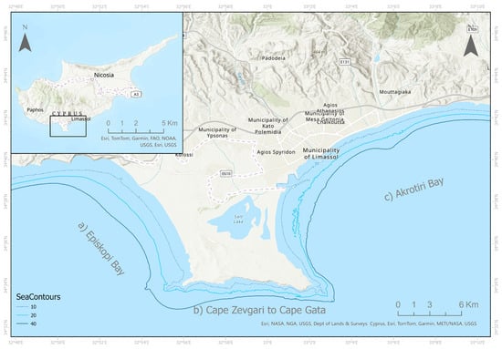
The availability of reliable and spatially distributed rainfall data is a key element flood and landslide risk assessment, both for forecasting and post-event analysis. In this context, this study evaluates the contribution of radar-based rainfall estimates to enhancing the spatial accuracy of precipitation fields with respect to those derived from rain gauge networks alone. The analysis was conducted over a ~100 km2 area in the Liguria Region, north-western Italy, characterized by a dense rain gauge network, with an average density of one gauge per 10 km2, and covers seven years of hourly rainfall observations. Radar-derived rainfall fields, available at a 1 × 1 km2 spatial resolution, were locally corrected across the study area by interpolating gauge-based local correction factors through an Inverse Distance Weighting (IDW) scheme. The corrected radar fields were then assessed through Leave-P-Out Cross-Validation and rainfall-intensity-based classification, also simulating scenarios with progressively reduced gauge density. The results demonstrate that radar-corrected estimates systematically provide a more accurate spatial representation of rainfall, especially for high-intensity events and in capturing the actual magnitude of local rainfall peaks, even in areas covered by a dense rain gauge network. Regarding the implications for rainfall-induced landslide hazard assessment, the analysis of 56 landslides from the ITALICA (Italian Rainfall-Induced Landslides Catalogue) database showed that including radar information can lead to significant differences in the estimation of rainfall thresholds for landslide initiation compared with gauge-only data.
Full article
(This article belongs to the Section Remote Sensing in Geology, Geomorphology and Hydrology)
►
Show Figures

Figure 1


