
Skip to Content
  • 2.9
    Impact Factor
  • 6.1
    CiteScore
  • 16 days
    Submission to First Decision
  • 3 days
    Acceptance to Publication

Applied Sciences

Applied Sciences is an international, peer-reviewed, open access journal on all aspects of applied natural sciences published semimonthly online by MDPI. The International Society for Plasma Medicine (ISPM) and the Polish Society of Applied Electromagnetics (PTZE) are affiliated with Applied Sciences and their members receive a discount on the article processing charges.

Get Alerted

Add your email address to receive forthcoming issues of this journal.

All Articles (94,385)

  • Article
  • Open Access

This study evaluates the performance of five conceptual hydrological models namely AWBM, BUDYKO, GR2M, IHACRES, and SIMHYD in simulating monthly streamflow across twelve tropical catchments in the Northern Pacific Region of Costa Rica. Building on existing regional hydrological modeling efforts, this study provides an intercomparison of lumped monthly conceptual models across steep, forest-dominated catchments characterized by bimodal precipitation patterns. The study aims to evaluate the relationship between model performance, complexity, structure, and calibration period duration. The Generalized Simulated Annealing (GSA) method was used for parameter optimization to assess its performance under these specific hydroclimatic conditions. Performance metrics, including KGE, PBIAS, D, and RSR, were computed to compare simulated and observed streamflows during calibration and validation periods. GSA proved effective in navigating complex, non-linear parameter spaces, handling diverse meteorological conditions. However, computational demands grew with model complexity. Simpler models converged faster, whereas higher-dimensional architectures increased costs without delivering substantial accuracy gains. All hydrological models exhibited satisfactory performance during calibration, with multiple independent metrics providing a more reliable assessment. These findings suggest that increased model complexity and overparameterization do not guarantee superior accuracy. Instead, parsimonious structures, such as GR2M and BUDYKO, often matched or outperformed heavier models, indicating that model performance is more influenced by structure and runoff generation representation than by complexity. Instead, for monthly streamflow simulation across the investigated tropical catchments, parsimonious structures, such as GR2M and BUDYKO, often matched or outperformed heavier models, indicating that model performance is more influenced by structure and runoff generation representation than by complexity. No single hydrological model universally outperformed the others, with model behavior remaining deeply context-dependent. Performance varied by catchment, underscoring that model strengths, weaknesses, and optimal choices depend on specific study objectives, catchment characteristics, and runoff generation representations. During validation, all models showed reduced simulation accuracy compared to calibration, particularly when calibrated on older data and validated on newer periods. This decline highlights challenges in temporal transferability caused by discrepancies in meteorological conditions and inter-annual climate variability. Given that no single model consistently outperforms the others, adopting multi-model intercomparisons frameworks offers a more reliable strategy. The methodology applied can be replicated in regions with similar conditions to assess water resources more accurately and support sustainable catchment management.

Appl. Sci.

5 November 2026
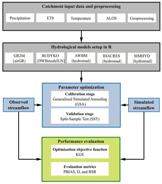
Flowchart of the research methodology adopted in this study.
  • Article
  • Open Access

Integrating CAD-based mine maps with GIS through ETL tools requires an intermediate spatial data format suitable for a range of applications. This industrial case study compares GeoJSON, GeoPackage and GML, each uncompressed and in ZIP archives, using production mine workings maps of three underground copper mines of KGHM Polska Miedź S.A. (1,179,967 vector features). The comparison was undertaken to support the enterprise’s internal mine map data integration needs. Eleven operations were timed in FME, GDAL/OGR and QGIS, covering local and network reading and writing as well as interactive display. Uncompressed GeoPackage was the fastest in nine of the eleven operations; in local reading in FME, it required 7.0 s, compared with 48.2 s for GeoJSON and 191.6 s for GML, and it was 24.76% and 39.94% smaller, respectively. ZIP compression reduced file sizes by 90.75–94.68%, with GeoJSON producing the smallest archive. Compression shortened network reading of GeoPackage and network writing of the text-based formats in FME (GeoJSON: from 991 to 172 s), but it slowed local reading and, for GeoPackage, zooming in QGIS (from 9 to 388 s). Working, transport and archival formats should therefore be selected against separate criteria, and format efficiency must be combined with change detection, concurrency control and limited disk operations in the ETL process.

Appl. Sci.

5 November 2026

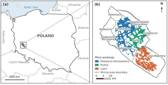
Location of the study area: (a) position of the Legnica–Głogów Copper District in Poland; (b) extent of the workings of the Polkowice-Sieroszowice, Rudna and Lubin mines against the boundaries of the mining areas. The extent of the workings and the mining area boundaries are shown in generalised form. Coordinate system: PL-1992 (EPSG:2180); national boundaries after Natural Earth (https://www.naturalearthdata.com).
  • Article
  • Open Access

Temperature-dependent mechanical behavior and wetting-induced swelling affect the stability of underground structures in expansive mudstone. Three modified constitutive models were evaluated against temperature-controlled triaxial compression and laterally constrained swelling tests. The Mohr–Coulomb strain-softening and Hoek–Brown-based unified hardening–softening models incorporated temperature effects and equivalent swelling strains. The unsaturated unified hardening model was extended through equivalent temperature–stress mapping. Mechanical calibration used data from 12 triaxial conditions, supplemented by evaluation at 40 °C after recalibration at 20 and 60 °C. Swelling parameters calibrated at 20 °C were held constant at higher temperatures. For the 12 calibration conditions, the Mohr–Coulomb model yielded the lowest errors in peak deviatoric stress and deviatoric stress at 5% axial strain. The hardening–softening model improved pre-peak response and peak-strain estimates relative to Mohr–Coulomb. The unsaturated model achieved the lowest pre-peak normalized root-mean-square error of 10.10% and a swelling mean absolute error of 0.22 percentage points across 40–80 °C, but overestimated deviatoric stress at 5% axial strain. The sensitivity results support a staged calibration procedure involving initial parameter estimation followed by joint refinement using the designated calibration data. These findings provide a basis for model selection and parameter calibration in analyses of temperature-dependent mechanical and swelling responses of expansive mudstone.

Appl. Sci.

5 November 2026

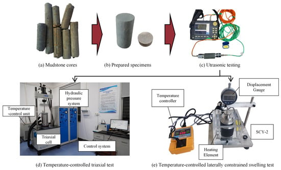
Rock sample preparation and test protocol.
  • Article
  • Open Access

Dynamic failure of roadways subjected to mining-induced seismicity poses a major challenge to support design and coal burst control in deep coal mines. Using the roadway of the 3102 working face at M Coal Mine in Inner Mongolia, China, as the engineering background, a UDEC-Trigon model was established to compare four support schemes: unsupported, bolt support, combined bolt and cable support, and combined support with bolts, cables, and hydraulic props. The results show that support configuration significantly affects roadway deformation, particle velocity, stress redistribution, and fracture development. Bolt support alone provides limited improvement, whereas the introduction of cables markedly reduces rib deformation, high-velocity ejection zones, and fracture propagation. The maximum left- and right rib displacements decrease from 0.75 and 0.65 m under the unsupported condition to 0.12 and 0.25 m under combined bolt and cable support, respectively. Tensile cracks are more widely distributed than shear cracks, with tensile failure dominating the shallow surrounding rock and shear failure occurring mainly in deeper zones. Fractal analysis further indicates that combined bolt and cable support effectively suppresses crack development and reduces fracture network complexity, whereas hydraulic props provide only limited additional improvement. Based on the numerical results, an optimized bolt and cable reinforcement scheme combined with roof pre-splitting blasting was implemented in the field. The maximum deformations of the roof, ribs, and bottom were reduced by 40.0%, 60.0%, and 55.6%, respectively. These findings provide a reference for support design and coal burst mitigation in deep coal roadways.

Appl. Sci.

5 November 2026

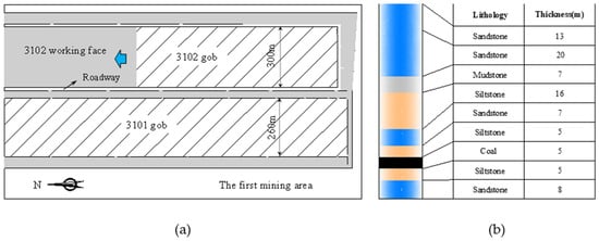
Geological and mining conditions of the study area: (a) layout of the 3102 working face; (b) lithological column of the roof and floor. The arrow indicates the advance direction of the 3102 working face.

Featured Articles of Last Quarter

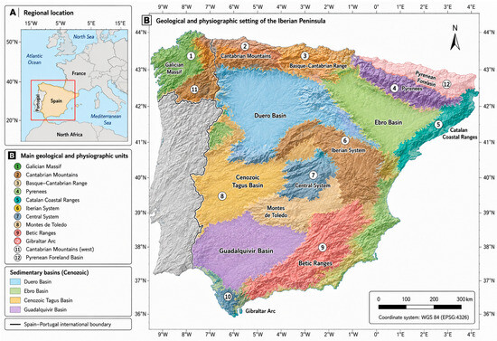
Geographical and geological setting of the study area: (A) Regional location of the Iberian Peninsula in southwestern Europe. (B) Main geological and physiographic units and major Cenozoic sedimentary basins of the Iberian Peninsula. The Spain–Portugal international boundary is also shown. Coordinates are referenced to WGS 84.
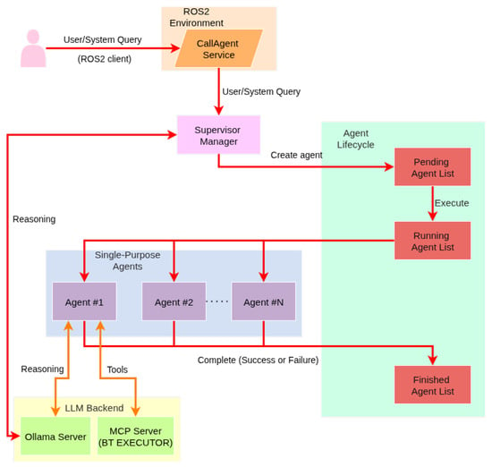
Overview of System Architecture.

Highly Accessed Articles

News & Conferences

Latest Issues

Open for Submission

Journal Sections

XFacebookLinkedIn
Appl. Sci. - ISSN 2076-3417