You are currently viewing a new version of our website. To view the old version click .

Remote Sensing, Volume 15, Issue 17

September-1 2023 - 244 articles

Cover Story: 
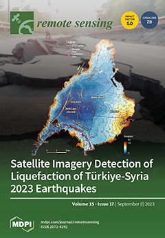
The 6 February 2023, earthquake doublet (Mw 7.7 and Mw 7.6) on the East Anatolian Fault Zone triggered widespread soil liquefaction in SE Türkiye and NW Syria. To address this, we refined a remote sensing method for mapping liquefaction. Using optical and radar satellite imagery, we identified 1850 liquefaction sites. The majority of them were located in river valleys, coastal plains, drained lakes, swamps, and lacustrine basins along the fault zone, revealing the influence of landform and surficial geology on liquefaction distribution. Remarkably, 95% of sites were within 25 km of the fault's surface trace, highlighting proximity to fault rupture as a more reliable predictor than epicenter distance. This desktop-based approach offers rapid and cost-effective earthquake-induced liquefaction mapping, aiding future hazard assessments. View this paper
  • Issues are regarded as officially published after their release is announced to the table of contents alert mailing list .
  • You may sign up for email alerts to receive table of contents of newly released issues.
  • PDF is the official format for papers published in both, html and pdf forms. To view the papers in pdf format, click on the "PDF Full-text" link, and use the free Adobe Reader to open them.

Articles (244)

  • Article
  • Open Access
15 Citations
3,410 Views
21 Pages

4 September 2023

Supraglacial lakes in Greenland are highly dynamic hydrological features in which glacial meltwater cumulates, allowing for the loss and transport of freshwater from a glacial surface to the ocean or a nearby waterbody. Standard supraglacial lake mon...

  • Article
  • Open Access
2 Citations
2,260 Views
20 Pages

Siamese Multi-Scale Adaptive Search Network for Remote Sensing Single-Object Tracking

  • Biao Hou,
  • Yanyu Cui,
  • Zhongle Ren,
  • Zhihao Li,
  • Shuang Wang and
  • Licheng Jiao

4 September 2023

With the development of remote sensing earth observation technology, object tracking has gained attention for its broad application prospects in computer vision. However, object tracking is challenging owing to the background clutter, occlusion, and...

  • Article
  • Open Access
16 Citations
2,769 Views
26 Pages

4 September 2023

Ship detection technology has achieved significant progress recently. However, for practical applications, lightweight ship detection still remains a very challenging problem since small ships have small relative scales in wide images and are easily...

  • Article
  • Open Access
1,883 Views
24 Pages

Neural Network-Based Wind Measurements in Rainy Conditions Using the HY-2A Scatterometer

  • Jing Wang,
  • Xuetong Xie,
  • Ruru Deng,
  • Mingsen Lin and
  • Xiankun Yang

4 September 2023

Wind measurement using spaceborne scatterometers has been used for various scientific and operational purposes. However, the major problem of such measurements is contamination by rain. To improve the wind measurement using the HY-2A scatterometer un...

  • Article
  • Open Access
2 Citations
1,899 Views
18 Pages

4 September 2023

Satellite precipitation data downscaling is gaining importance for climatic and hydrological studies at basin scale, especially in the data-scarce mountainous regions, e.g., the Upper Indus Basin (UIB). The relationship between precipitation and envi...

  • Article
  • Open Access
4 Citations
2,499 Views
20 Pages

4 September 2023

Mesoscale eddies play a crucial role in the transport of mass, heat, salt and nutrients, exerting significant influence on ocean circulation patterns, biogeochemical processes and the global climate system. Based on Lagrangian-Averaged Vorticity Devi...

  • Article
  • Open Access
13 Citations
4,485 Views
17 Pages

Vessel Detection with SDGSAT-1 Nighttime Light Images

  • Zheng Zhao,
  • Shi Qiu,
  • Fu Chen,
  • Yuwei Chen,
  • Yonggang Qian,
  • Haodong Cui,
  • Yu Zhang,
  • Ehsan Khoramshahi and
  • Yuanyuan Qiu

4 September 2023

The Sustainable Development Goals Science Satellite-1 (SDGSAT-1) Glimmer Imager for Urbanization (GIU) data is very sensitive to low radiation and capable of detecting weak light sources from vessels at night while significantly improving the spatial...

  • Article
  • Open Access
4 Citations
2,028 Views
20 Pages

4 September 2023

Scene matching plays a vital role in the visual positioning of aircraft. The position and orientation of aircraft can be determined by comparing acquired real-time imagery with reference imagery. To enhance precise scene matching during flight, it is...

  • Article
  • Open Access
6 Citations
2,190 Views
13 Pages

Estimating Leymus chinensis Loss Caused by Oedaleus decorus asiaticus Using an Unmanned Aerial Vehicle (UAV)

  • Bobo Du,
  • Xiaolong Ding,
  • Chao Ji,
  • Kejian Lin,
  • Jing Guo,
  • Longhui Lu,
  • Yingying Dong,
  • Wenjiang Huang and
  • Ning Wang

4 September 2023

Oedaleus decorus asiaticus is one of the dominant harmful pests in central Inner Mongolia, China. Large-scale outbreaks of this pest create many serious problems in animal husbandry and agriculture. Therefore, understanding the underlying mechanisms...

  • Article
  • Open Access
13 Citations
3,888 Views
25 Pages

4 September 2023

Despite significant advancements in remote sensing object tracking (RSOT) in recent years, achieving accurate and continuous tracking of tiny-sized targets remains a challenging task due to similar object interference and other related issues. In thi...

of 25

Get Alerted

Add your email address to receive forthcoming issues of this journal.

XFacebookLinkedIn
Remote Sens. - ISSN 2072-4292