Article

Deconstructing the Evolution of Historical Urban Landscapes: A Multidimensional Layering Approach
1
School of Architecture & Urban Planning, Lanzhou Jiaotong University, Lanzhou 730070, China
2
School of Marxism, Beijing Forestry University, Beijing 100083, China
3
College of Architecture & Urban Planning, Tongji University, Shanghai 200092, China
4
Welsh School of Architecture, Cardiff University, Wales CF10 3AT, UK
5
School of Architecture & Fine Art, Dalian University of Technology, Dalian 116024, China
*
Author to whom correspondence should be addressed.
Land 2026, 15(5), 869; https://doi.org/10.3390/land15050869
Submission received: 21 March 2026 / Revised: 10 May 2026 / Accepted: 12 May 2026 / Published: 18 May 2026

Abstract

As a form of living heritage, Historic Urban Landscapes (HULs) have long been limited by the static perspectives and reductionist tendencies of conventional conservation and research approaches. Although the geological and archaeological concept of “stratification” offers a methodological basis for understanding the diachronic evolution of heritage, its unidimensional temporal lens fails to capture the inherent complexity and systemic nature of historic urban landscapes. To address this gap, this study proposes a “multidimensional stratification” theoretical framework through theoretical critique and paradigm reconstruction. The framework introduces innovations at the ontological, epistemological, and methodological levels, positing that the evolution of historic urban landscapes emerges from the nonlinear interaction and dynamic interweaving of four core dimensions: time, space, society, and value. It further systematizes five intrinsic attributes of such landscapes: authenticity, integrity, continuity, adaptability, and dynamism. Building on this foundation, the paper constructs a systematic analytical pathway—elements–processes–patterns–modes–drivers–characteristics—that enables dynamic analysis from micro-level identification to macro-level generalization, offering a scalable tool for HUL conservation and regeneration. To demonstrate the framework’s applicability, the historic urban area of Shenyang—a nationally designated historical and cultural city—is selected as a case study. Its urban landscape comprises four core districts: the Shengjing City District, the South Manchuria Railway Concession District, the Commercial Port District, and the Tiexi Industrial District, representing historical strata from the Qing dynasty capital, modern colonial planning, commercial opening, to industrial heritage. Using the multidimensional stratification approach, this study elucidates the spatial complexity, temporal nonlinearity, social dynamism, and value pluralism embedded in Shenyang’s historic urban area. Corresponding conservation strategies grounded in holism, dynamism, and differentiation are proposed. The research not only advances the theoretical understanding of HUL but also provides a novel paradigm—integrating holistic, dynamic, and operational perspectives—for the conservation, renewal, and regenerative practice of historic urban landscapes worldwide.

1. Introduction

The Historic Urban Landscape (HUL), in its capacity as both material repository and intangible witness to the accumulation of human civilisation, undergoes formation and evolution through a protracted and intricate dynamic process. According to UNESCO’s concepts regarding historic urban landscapes, HUL does not refer solely to isolated heritage elements such as historic buildings, cultural relics, or traditional neighborhoods, but rather to a complex urban landscape system formed over a long historical evolution, comprising the natural environment, the built environment, spatial patterns, social life, cultural memory, and perceptions of value. Its core characteristics are reflected not only in the historicity of the physical remains but also in the continuous evolution of the urban environment as a whole, the coexistence of overlapping historical layers, the ongoing participation of social life, and the dynamic generation of diverse values.
Urban historical landscapes possess unique characteristics that distinguish them from general urban heritage sites. First, they exhibit a sense of wholeness: HULs are not simply a collection of individual cultural relics or historic buildings, but rather a holistic historical environment formed by the interplay of landscape patterns, topography, river systems, street networks, land parcel structures, architectural ensembles, public spaces, visual corridors, and urban functions. Layered Nature: Urban Historic Landscapes are not static remnants of a single historical period, but rather the result of multiple historical phases continuously overlapping, transforming, covering, continuing, and reinterpreting one another within the same urban space. Spatial forms, architectural types, social activities, and cultural memories from different eras often form complex historical layers through coexistence, nesting, discontinuity, or regeneration. Vitality: HUL is not a display-oriented heritage detached from real life, but rather a living space that continues to serve practical functions such as residents’ daily lives, local commerce, public interaction, festive rituals, cultural transmission, and urban renewal. Its preservation must not be divorced from contemporary social use and urban development needs. Diversity: The significance of urban historic landscapes stems not only from their age, architectural artistry, or historical events, but also from multiple values such as local identity, collective memory, social relations, cultural symbols, aesthetic experiences, ecological environments, and sustainable development. Moreover, these values are constantly reinterpreted as social perceptions, governance objectives, and modes of use evolve.
The question of how to systematically comprehend, interpret and safeguard this ‘living’ heritage has become a core issue in a range of interdisciplinary fields, including urban and rural heritage conservation, urban planning and human geography. Conventional conservation methodologies frequently regard historic urban districts as static, isolated ‘artefacts’ or ‘specimens’, placing a premium on ‘freeze-frame’ preservation of specific historical cross-sections or singular value dimensions. This approach has been demonstrated to cause a significant fracture in the temporal and spatial continuity of heritage, thus overlooking its dynamic, layered, and systemic nature as an organic entity. Consequently, conservation practices become disconnected from the authentic, complex historical evolution of these spaces [1].
Reflection on this predicament prompted academia to seek a theoretical tool capable of revealing the historical formation process and its intrinsic motivations. The concept of ‘layering’ thus entered the research landscape. The conceptual framework under discussion has its origins in the disciplines of geology and archaeology. In the field of geology, the Law of Superposition, first proposed by Nicolas Steno in 1669, established the temporal logic for interpreting the history of the Earth through the analysis of stratigraphic sequences [2]. The adoption of this methodology by archaeology has resulted in the development of archaeological stratigraphy. Through the excavation and deconstruction of cultural deposits, this discipline determines the relative chronology of remains and reconstructs the historical sequence of human activity [3]. The fundamental premise of this concept is the recognition that the contemporary state is the result of a series of diachronic events, and that the deconstruction of stratigraphic sequences can be utilised to reverse-engineer historical information regarding temporal change.
Furthermore, scholars have noted that the logic of stratification can be equally applied to the study of cities and cultural heritage. As scholars such as Peter Hall have noted, urban spaces constitute the physical manifestation of historical processes; dynamic systems formed through the interweaving and layered sedimentation of social, economic, and cultural activities. The 2011 UNESCO Recommendation concerning the Safeguarding and Sustainable Management of Historic Townscapes formally established the ‘Layering Approach’ as one of the core methodologies for HUL conservation. The objective of this approach is to comprehend the configuration and progression of urban landscapes by identifying their material and immaterial stratigraphic layers. This provides a foundation for the conservation and management of these landscapes.
Nevertheless, the prevailing layering theory and its applications continue to demonstrate significant limitations. Firstly, the majority of research remains confined to analysing ‘vertical layering’ (diachronic evolution) along the temporal dimension, lacking comprehensive consideration of ‘horizontal layering’ (synchronic associations) across multiple dimensions such as spatial, functional, social, and value-based factors. Secondly, the layering process is often interpreted in a simplistic manner as the physical accumulation of material entities, thus overlooking the active role of immaterial elements (e.g., social memory, cultural practices, and power relations) and their mechanisms of interaction and integration with material carriers. Thirdly, there is a paucity of in-depth analysis of the underlying mechanisms of dynamic layering processes, failing to reveal the complex non-linear interactions and emergent patterns among elements across different dimensions. These tendencies towards ‘one-dimensionalisation’ and ‘materialisation’ render extant theories ill-equipped to adequately address the inherent complexity and systemic nature of historical urban landscapes.
Drawing upon the critical reflections that have been previously outlined, this study seeks to broaden and refine the theoretical framework of conventional layering concepts. It innovatively proposes the theoretical framework of ‘multidimensional layering’. The theory posits that the evolution of historical urban landscapes does not occur in a straightforward manner as a simple superposition along a singular timeline. Rather, it is a complex network system formed by the mutual coupling and dynamic interweaving of four core dimensions: time, space, society, and value. The framework under discussion here reconfigures the theoretical paradigm across three philosophical dimensions: ontology, epistemology, and methodology. From an ontological perspective, the concept of urban heritage is understood as a dynamic, multidimensional networked entity, rather than a static object. From an epistemological perspective, it emphasises holistic understanding through multidimensional perspectives to grasp the truth of complex systems. Methodologically, it advocates interdisciplinary, systematic and dynamic analytical approaches.
In order to validate the explanatory power and operational value of this theoretical framework, this paper further constructs a multidimensional layered analytical pathway encompassing ‘elements, processes, patterns, modes, drivers, characteristics’. This pathway aims to systematically analyse the intrinsic logic and external manifestations of layered phenomena within historic neighbourhoods. The pathway provides a systematic analytical tool for the conservation and regeneration of Historic Urban Landscapes. This tool facilitates analysis progressing from the particular to the general, from the dynamic to the static, and from the concrete to the abstract.
This study not only deepens and supplements the theoretical framework of the HUL concept but also represents a pioneering attempt to transcend the prevailing reductionist and static paradigms within heritage conservation. Adopting a multidimensional, layered perspective is conducive to the acquisition of a more comprehensive and profound understanding of the generative logic and intrinsic value of historic urban landscapes. This approach provides a robust theoretical foundation and scientific decision-making support for their adaptive management and sustainable regeneration.

2. Materials and Methods

2.1. Research Proposal Design

2.1.1. Research Methods

(1)
Literature review and theoretical synthesis
Using a literature review approach, this study systematically examines relevant theories regarding urban historical landscapes, cultural landscapes, heritage stratification, urban morphological evolution, the production of social space, and heritage value assessment. It focuses on analyzing the issues of static interpretation, objectification, and a singular value orientation found in traditional heritage conservation methods and further discusses the theoretical possibilities and limitations of applying the concept of “stratification” from geology and archaeology to the field of urban heritage research. Building on this foundation, the study reflects on the tendency in existing stratification research to emphasize time series and the identification of material remains. It proposes that the stratification of urban historical landscapes should not be understood merely as the temporal superimposition of historical elements, but rather as the result of multidimensional interactions among time, space, society, and value. Through theoretical induction, this paper further distills five core attributes of the urban historical landscape—authenticity, integrity, continuity, adaptability, and dynamism—and establishes them as the foundation for constructing a multidimensional stratification theoretical framework.
(2)
Theoretical Construction Method
Based on theoretical analysis and employing a theoretical constructivist approach, this study proposes a “multidimensional stratification” analytical framework. The formation of urban historical landscapes is not merely a historical accumulation along a single temporal dimension, but rather a complex system shaped by the combined effects of temporal evolution, spatial configuration, social practices, and value construction. Within this framework, the temporal dimension serves to reveal the continuity, discontinuity, superimposition, and regeneration across different historical periods; the spatial dimension identifies the material manifestations of historical processes in urban patterns, street and alley networks, architectural forms, public spaces, and the natural environment; the social dimension explains how governments, residents, communities, capital, tourists, and other stakeholders participate in the production and reproduction of historical landscapes through daily use, governance practices, and cultural activities; and the value dimension assesses the multiple meanings of historical landscapes in terms of history, culture, society, aesthetics, economics, and sustainable development.
(3)
Single-case study method
To test the applicability and explanatory power of the multidimensional stratification theory framework, this paper proposes to conduct an empirical analysis using a representative case study. The selection of the case will adhere to the following principles: First, the case site should have a long historical development process and a relatively clear historical evolution; second, it should preserve a certain quantity and variety of historical remnants, including street and alley patterns, historic buildings, public spaces, cultural nodes, or traditional scenes of daily life; third, the site should exhibit distinct characteristics of active use, meaning that the historic landscape remains connected to contemporary residents’ lives, commercial activities, cultural practices, or urban renewal; fourth, the site should face certain conflicts between preservation and development, thereby reflecting the practical challenges encountered in HUL conservation.
(4)
Multi-source data collection method
To support the case studies, this paper employs a multi-source data collection method to establish the foundational database required for multidimensional stratigraphic analysis of urban historical landscapes. The data sources primarily include the following categories: First, historical documentary materials, including local annals, historical archives, urban development histories, planning documents, historical photographs, historical maps, cultural heritage survey data, and relevant research findings, which are used to reconstruct the developmental trajectory of the case study sites across different historical periods. Second, spatial imagery data, including historical maps, current topographic maps, remote sensing imagery, aerial photographs, cadastral maps, architectural survey data, and planning maps, are used to identify the evolution of urban spatial patterns, street and alley textures, building distributions, and landscape nodes. Third, heritage resource data, including protected cultural relics, historic buildings, historic districts, traditional architectural features, industrial heritage, cultural routes, intangible cultural heritage, and local cultural resources, are used to establish an inventory of historical landscape elements in the case study area. Fourth, social survey data, including field surveys, interview records, questionnaire surveys, behavioral observations, records of community activities, and public perception data, are used to analyze the social usage patterns, local identity, and public perception of value regarding the historical urban landscape. Fifth, current development data, including land use, commercial formats, traffic organization, population activities, tourism development, renewal projects, and conservation plans, are used to assess the adaptability of the historic urban landscape within contemporary urban development and identify sources of pressure. Through cross-verification of multi-source data, this paper aims to avoid the one-sidedness caused by relying on a single data source, enabling the case analysis to simultaneously cover multiple dimensions such as historical evolution, spatial form, social activities, and value perception.

2.1.2. Research Framework

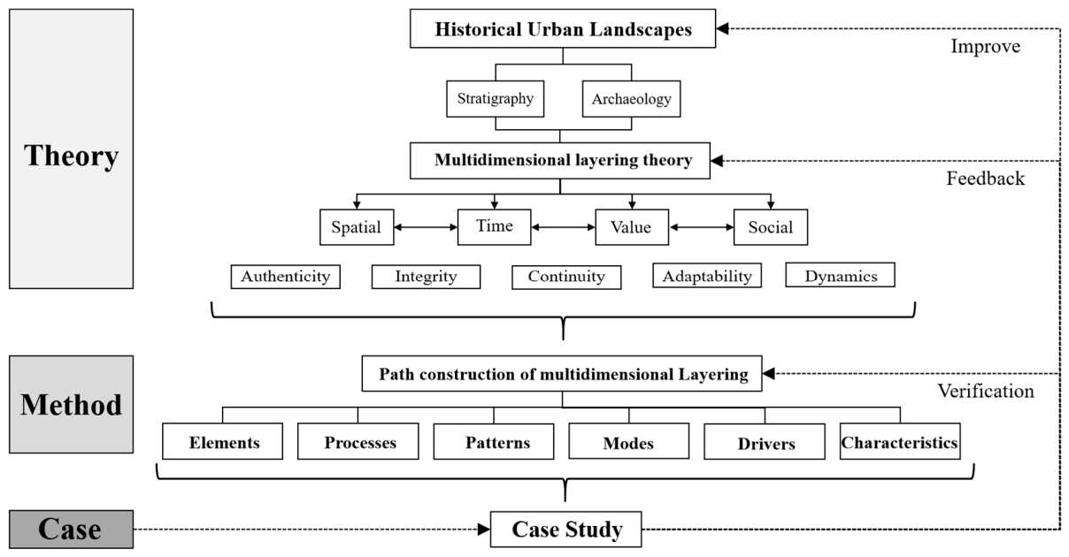
This study adopts a three-stage methodological strategy—theoretical critique, paradigm reconstruction, and case validation—to address the long-standing “static perspective and reductionist tendencies” in the conservation and research of Historic Urban Landscapes.
(1)
At the ontological level, HUL is understood as a “living stratified entity” formed through the nonlinear interaction and dynamic interweaving of four core dimensions: time, space, society, and value.
(2)
At the epistemological level, we emphasize the authenticity of multi-agent meaning-making and value conflicts, rejecting the narrative of a single expert.
(3)
At the methodological level, we construct and apply a systematic analytical framework comprising “elements, processes, laws, patterns, drivers, characteristics,” utilizing single-case studies to achieve dynamic analysis and decision support that progresses from micro-level identification to macro-level generalization (Figure 1).

2.1.3. Research Subject

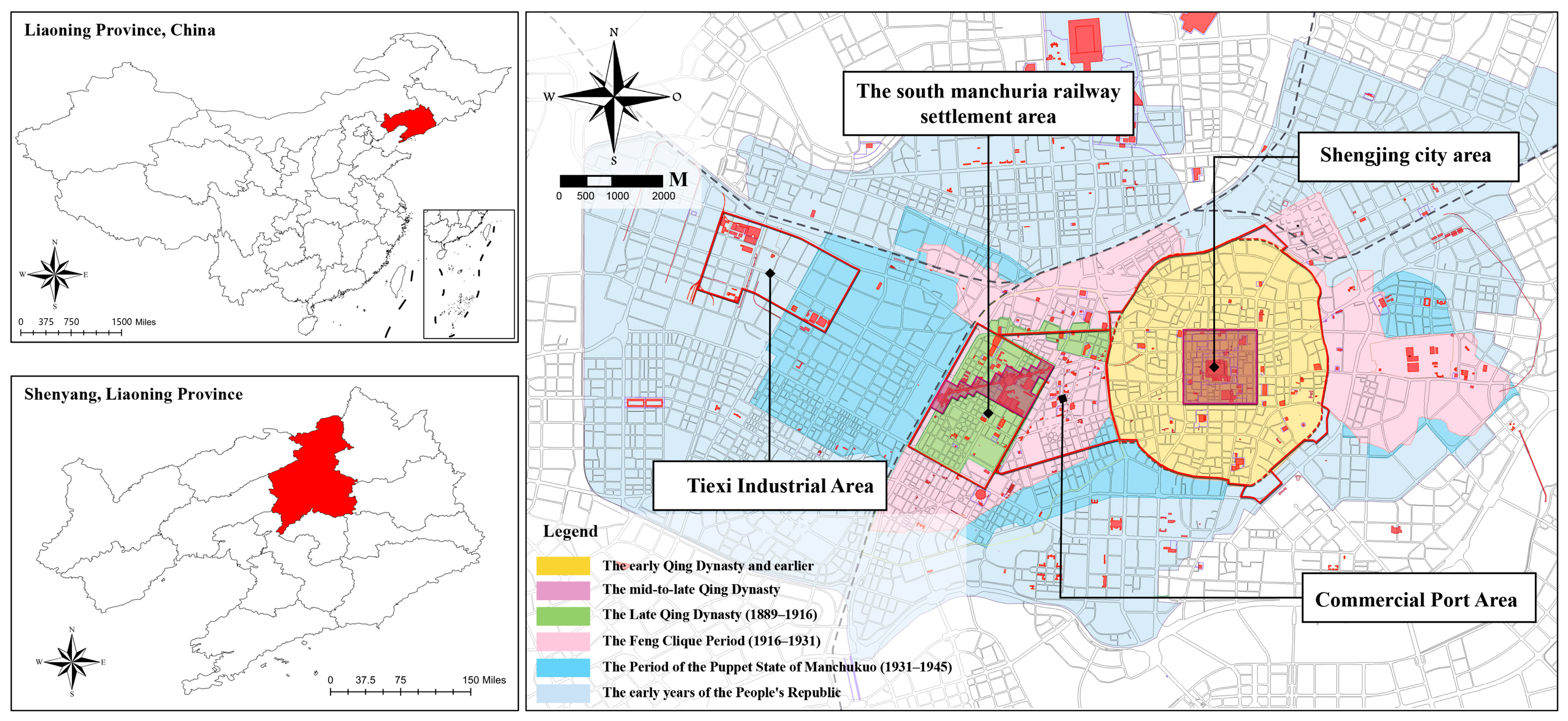
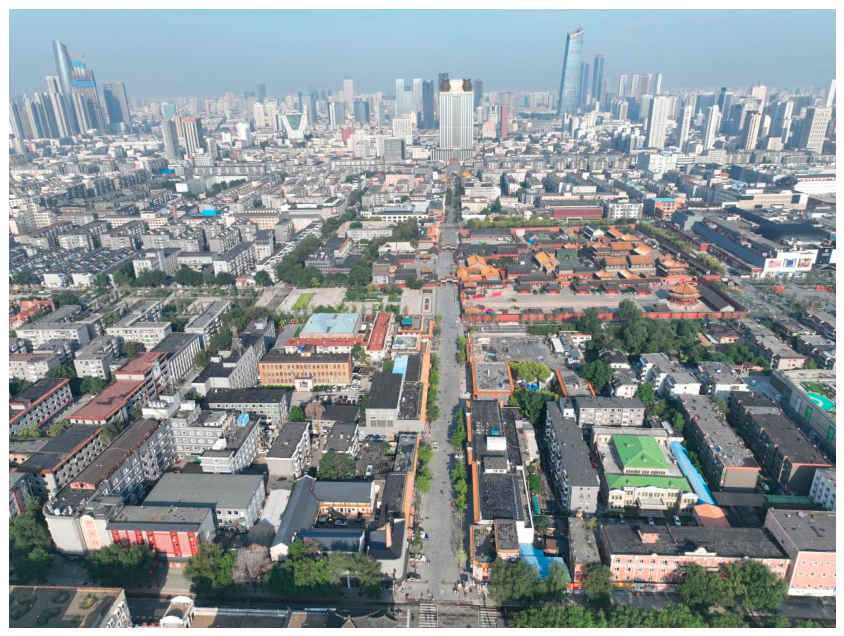
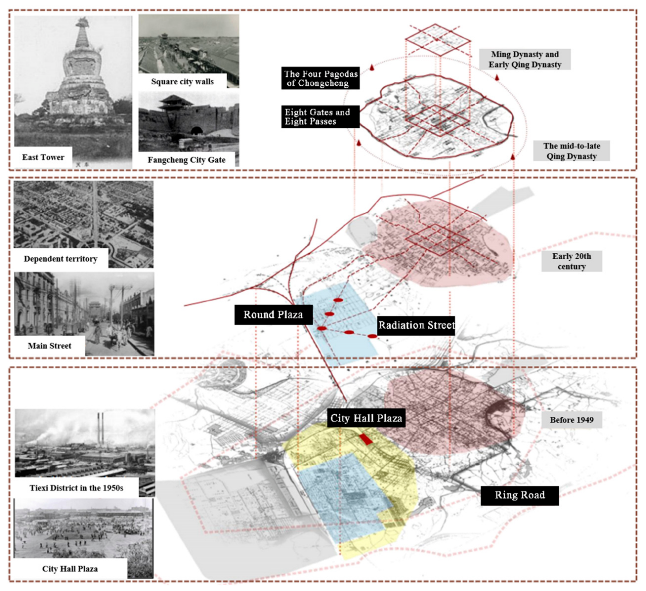
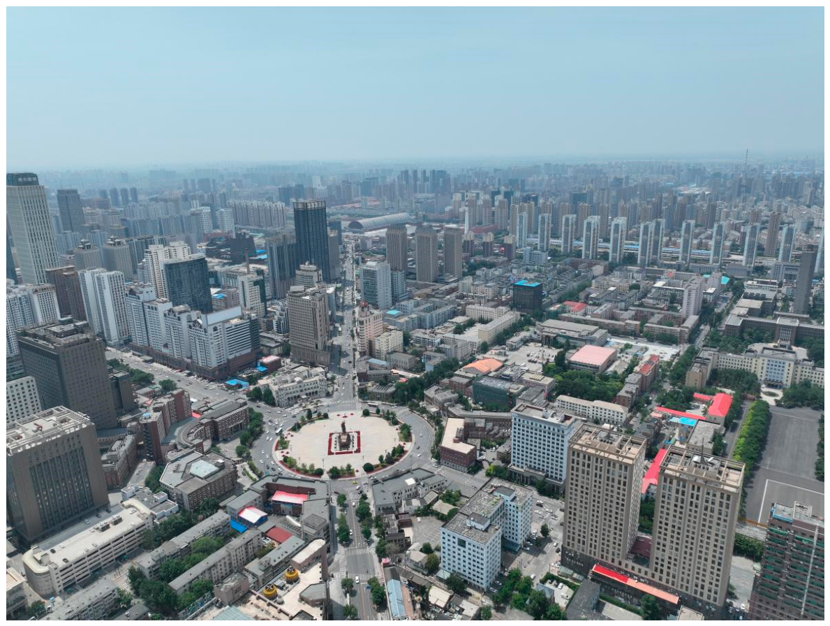
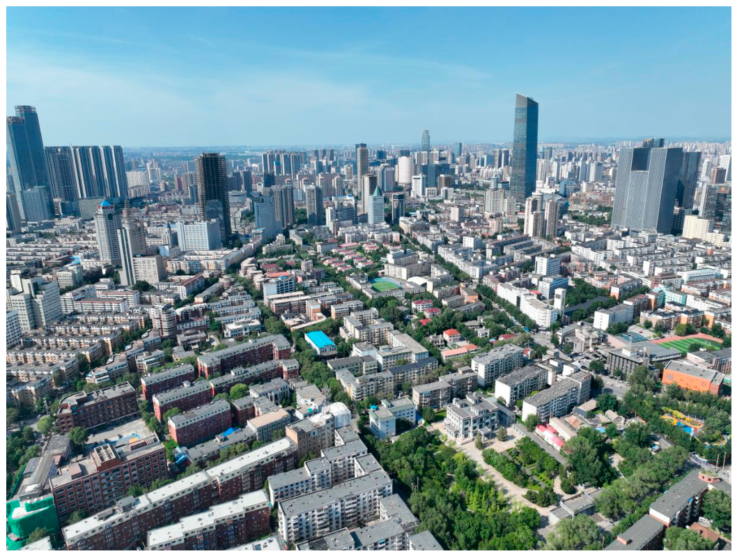
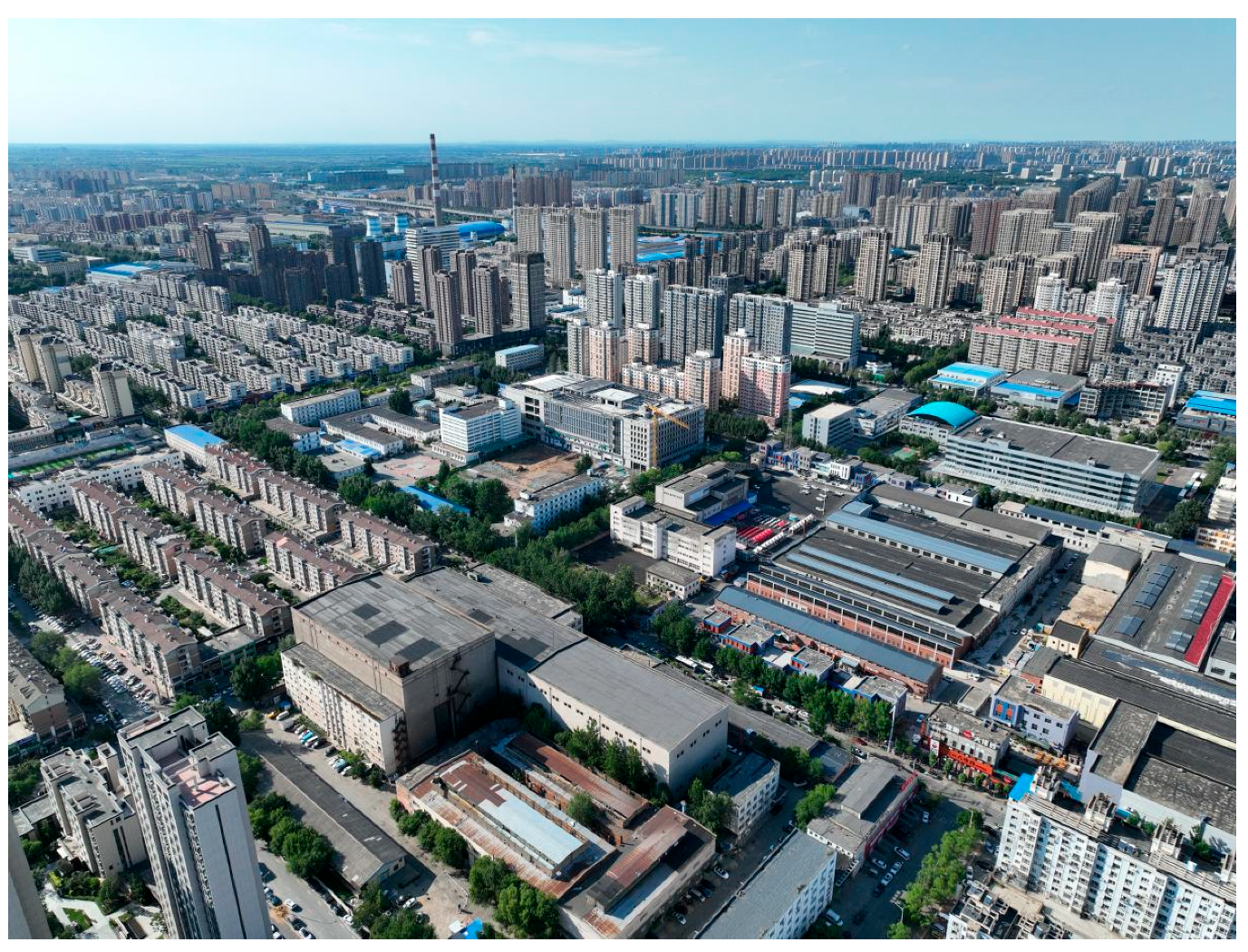
This study selects Shenyang as its single case study (Figure 2), primarily due to its typicality and complexity in the context of China’s urban historical evolution, Northeast regional development, and the preservation of urban historical landscapes. Shenyang is not only a nationally designated historical and cultural city but also served as the capital during the early Qing Dynasty, a modern political and military hub of the Northeast, and a major industrial base of the People’s Republic of China. Its urban historical landscape exhibits distinct characteristics of overlapping historical periods, cultural integration, coexistence of diverse spatial types, and the symbiosis of multiple values. As a single-case study subject, Shenyang is well-suited to fully demonstrate the holistic nature, layered accumulation, dynamic vitality, and value diversity of urban historical landscapes, while also providing an explanatory empirical context for the application of the “multidimensional layered accumulation” theoretical framework.
First, Shenyang has a long and continuous historical development, reflecting the temporal layering of the city’s historical landscape.
Second, Shenyang preserves a diverse range of historical landscapes, including the Qing Dynasty capital, imperial tombs, traditional commercial districts, modern railway trading hubs, and industrial heritage sites, demonstrating the spatial integrity and complexity of the Historical Urban Landscape.
Third, Shenyang’s historical landscapes remain closely intertwined with contemporary residents’ daily lives, commercial activities, cultural consumption, tourism, and urban renewal, thereby embodying the vitality of HUL.
Fourth, Shenyang embodies multiple values, including imperial culture, Manchu culture, modern history, memories of the War of Resistance, industrial culture, and local life memories, thereby demonstrating the value diversity of HUL.
Fifth, Shenyang currently faces real-world tensions between preservation and renewal, historical inheritance and functional transformation, and heritage display versus the continuity of daily life, making it suitable for testing the explanatory power and practical applicability of the multidimensional stratification theoretical framework.
Shenyang was not selected as a generic urban sample, but rather as a typical case characterized by a high degree of historical stratification and contemporary complexity, to provide an in-depth interpretation of the multidimensional interactive mechanisms of urban historical landscapes across temporal, spatial, social, and value dimensions. Through a single-case study of Shenyang, the validity of the “multidimensional stratification” theoretical framework can be verified within a specific urban context, and methodological references can be provided for the conservation, renewal, and regeneration of similar historical urban landscapes.

2.2. The Origin and Development of the Concept of Layering

The concept of layering was initially introduced into geology, where the term ‘layering’ is derived from the Greek words ‘stratum’ and ‘to stratify’. Stratigraphy denotes the method of studying the layered structure of rocks and minerals. In the context of stratigraphic research, layering is defined as the multi-layered geological structures that have been formed over time through various geological processes, including sedimentation, erosion, and climatic shifts. These processes occur within rock strata, sediments, and minerals that are present on or beneath the Earth’s surface. In 1669, the Danish scientist Nicolas Steno proposed the Law of Superposition, which states that ‘in an undisturbed depositional environment, sediments or rock layers accumulate sequentially to form stratigraphic sequences’. This fundamental principle was articulated by the aforementioned author in his treatise <De solido intra solido> [4]. Layering is a process that occurs over time and is driven by ongoing environmental changes. This process leads to the formation of distinct sedimentary layers, which are deposited as a result of the sedimentation of different layers of rock or soil. This layered accumulation is the result of continuous temporal and geological transformations, which enable stratigraphic analysis and interpretation based on chronological relationships. The fundamental principle of this theory is that ‘the present is the key to the past’, which suggests that the geological history of Earth can be understood by studying the superimposed stratigraphic sequences [5].
The concept of layering has been adopted by archaeology, which employs it to describe cultural deposits within human historical sites. This development has resulted in the establishment of archaeological stratigraphy, also referred to as archaeological layering. Stratigraphy, as the most fundamental theory and method within archaeology, is defined as ‘a method for determining the relative chronological relationships between sites by assessing the sequential processes of deposit formation within them’. Cultural sites are often distinguished by the presence of multiple strata. Through the process of excavation, analysis, and deconstruction of these layers, the processes of human historical, cultural, and social change are reconstructed. Artefacts and remains from distinct historical periods accumulate sequentially over time, forming multi-layered cultural deposits. Each stratum is defined by the accumulation of artefacts, structures, tools and other materials that are characteristic of a specific historical epoch. Through the process of excavation and analysis of these cultural layers, researchers are able to elucidate the social, cultural, and economic activities of disparate historical phases [6].
The concept of layering, as applied in the fields of geology and archaeology, has led scholars to discover that this theory is not only applicable to natural phenomena and archaeological sites but can also be used to describe multidimensional superimposition processes within cities, cultures, societies, and historical phenomena. This is particularly evident in the disciplines of cultural heritage conservation and urban historical landscape studies, where layering has assumed a pivotal role in theoretical frameworks. This development underscores the necessity for the integration of layering as a critical theoretical tool, facilitating a comprehensive understanding and the preservation of urban heritage. In 1985, the British scholar Peter Hall made the following observation in his work <The Cultural Heritage of the City: The concept of preservation and regeneration> that urban spaces are predicated on the notion that these spaces are not merely physical manifestations of historical processes, but dynamic systems formed by the interweaving of social, economic, and cultural activities [7]. It is evident that every city block, square and building is representative of the spatial sedimentation of cultural, social and economic activities across multiple historical periods. It is evident that space bears not merely the physical visage of history but also records traces of diverse social contexts, cultural identities, and historical events. Consequently, urban heritage is defined not just by individual buildings or stylistic expressions but as a living historical document through which the footprints of temporal and societal transformation can be traced. This provides a robust theoretical foundation for the layering approach [8].
In the domain of heritage conservation, the layering approach was initially put forward in the <Recommendation on the Historic Urban Landscapes (2011)>. This methodology is a pivotal element of the HUL conservation framework, with the objective of offering novel perspectives and practical tools for the preservation of historic urban landscapes. Historic cities are not merely static physical spaces, but complex landscapes formed through the layered accumulation of multiple, continuously evolving historical and cultural elements. The concept of layering encompasses more than the mere collection and consolidation of fundamental data on urban historical landscapes [9]. It is imperative to recognise the profound significance of this concept in the pursuit of comprehension of urban structures and their evolutionary processes, the deepening of appreciation of urban values, and the undertaking of preservation of urban landscapes. As a complementary theoretical framework to HUL theory and methodology, layering theory also provides the field of urban conservation with concrete research tools and practical operational instruments [10,11].

2.3. Multidimensional Layering Theory Construction

A critical examination of the one-dimensional temporal-spatial framework of layering theory reveals that the evolution of ‘layering’ into a ‘multidimensional layering’ theory signifies more than a mere accumulation of terminology. Instead, it symbolizes an iterative theoretical paradigm shift, propelled by profoundening disciplinary understanding and the escalating intricacy of research subjects. Within the HUL context, an exclusive focus on ‘vertical layering’ along the temporal axis while disregarding ‘horizontal layering’ across spatial, social, and functional dimensions results in a reduction in layering to the physical accumulation of material entities. This approach fails to consider the interaction and integration of immaterial elements and does not analyze the mechanisms underlying the dynamic layering process. Extant research has focused predominantly on diachronic evolution within a single dimension, thereby failing to reveal the interactive relationship between material and immaterial layering. It is particularly noteworthy for its emphasis on the active role of sociocultural elements in the layering process. The innovative introduction of ‘multidimensionality’ addresses this gap.

2.4. The Multidimensional Philosophical Implications

‘Multidimensionality’ in philosophy refers to the understanding of the complexity of things or phenomena beyond a single perspective, encompassing multiple angles and layers, emphasizing wholeness and complexity. From an ontological perspective, the essence of things is inherently multi-layered, encompassing dimensions such as matter, spirit, time, space, and social relations. From an epistemological perspective, the multidimensionality of cognition is manifested through multi-angle, multi-perspective analysis, thereby unveiling the multifaceted nature of truth. From a methodological perspective, multidimensional methodology pursues a comprehensive description and dynamic grasp of complex systems, rather than being confined to single variables or isolated relationships.
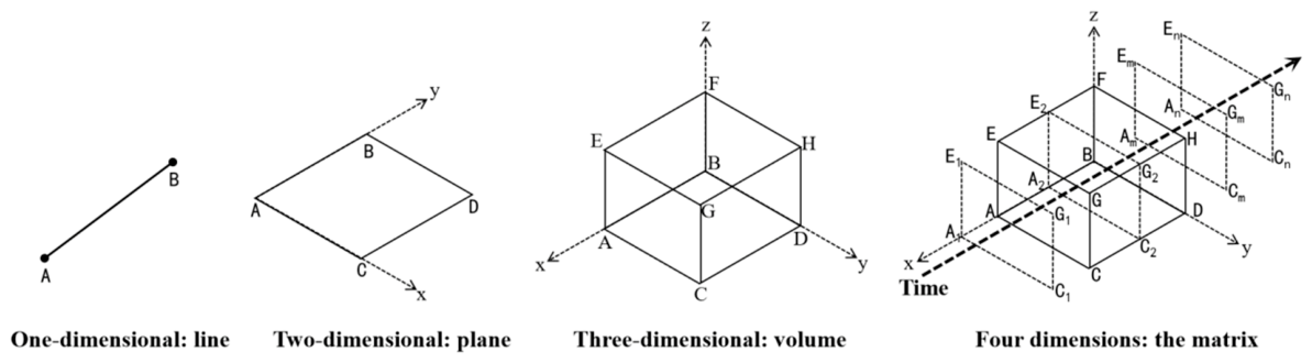
The term ‘one-dimensional’ is used to describe a single perspective or a linear thinking method. In spatial terms, this can be illustrated as straight lines or point-line relationships, or the simple, unidirectional connections between things. The term ‘two-dimensional’ is used to describe analyses that are conducted from dual perspectives, involving simple interactions or comparative relationships. The phenomenon manifests itself in a spatial context as either two intersecting lines or a branching line forming a planar structure. This configuration serves as a representation of the development of entities across two dimensions. The term ‘three-dimensional’ is used to emphasize a multi-angle analytical approach, capturing connections across multiple directions. The spatial representation of the concept under consideration is characterized by the presence of folded surfaces. The spatial structure in question is formed by the folding of two points on a two-dimensional plane through each other, thereby resulting in a three-dimensional spatial structure. This process adds depth and complexity that extends beyond the plane. The term ‘four-dimensional’ is introduced to denote the dimension of time, thereby creating a dynamic and evolving analytical perspective. The integration of three-dimensional structures with time is the spatial representation of dynamic modes formed based on spatiotemporal relationships (Figure 3).
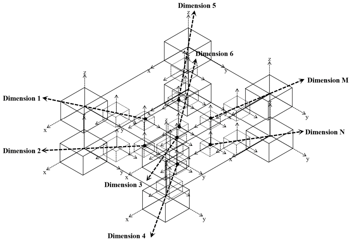
The term ‘multidimensional’ is used to describe complex networks that extend beyond four dimensions, involving multiple relationships and systemic interactions. This is not merely a simple superposition of dimensions; rather, it underscores the comprehensive nature of systems, manifesting as the networked structure of open systems and highlighting the interweaving and interaction of multidimensional perspectives. The transition from a ‘one-dimensional’ to a ‘four-dimensional’ approach can be conceptualized as a simplification of independent variables or causal relationships. This can be illustrated by decomposing motion directions or considering space and time separately. However, the concept of ‘multidimensionality’ underscores the intricate interplay and interconnectedness among all dimensions, which are inextricably intertwined and inherently cannot be readily decomposed into independent variables. A modification in one dimension often precipitates intricate alterations in other dimensions. In a ‘multidimensional’ space, phenomena cannot be understood by simplistically decomposing them into several independent variables or causal relationships. It is hypothesized that within a multidimensional space, a change in a physical quantity will arise from the mutual coupling and influence of variables across multiple dimensions. The relationship between dimensions is not a simple summation; rather, it is a complex, dynamic interaction. A change in one dimension may trigger chain reactions in others, and such reactions cannot be predicted through simple linear or independent variable modes. This phenomenon can be likened to the intricate interplay of multiple factors within a complex system, wherein any alteration in a single factor ultimately impacts the entire system through complex feedback mechanisms. Consequently, it cannot be reduced to the influence of any isolated, independent factor (Figure 4).

3. Results

3.1. Definition of Multidimensional Layering

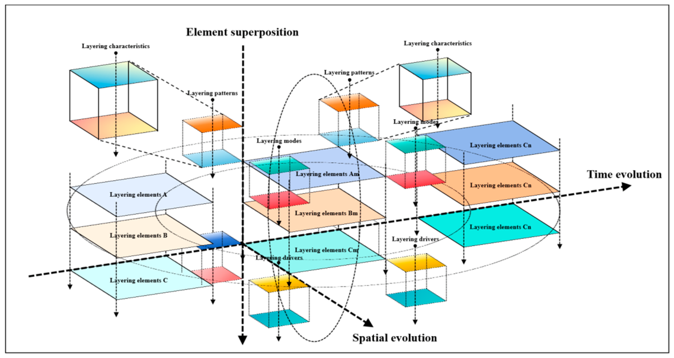
From a philosophical perspective, ‘multidimensional layering’ signifies an analytical framework that transcends singular dimensions, embodying complexity and dynamism. The concept under scrutiny herein places particular emphasis on the process of superposition and evolution within a multidimensional space. This concept delineates the modus operandi of phenomena, formed through the continuous layering of elements across multiple dimensions—such as space, time, society, and culture. Each stratum of the system is a continuation and expansion of the preceding one, and it simultaneously exerts influence on the form and function of the entire system. The phenomenon under scrutiny manifests the characteristics of dynamic accumulation and holistic emergence [12]. The concept of multidimensional stratification challenges conventional cognitive boundaries, transcending the conventional categories of three-dimensional historical space and four-dimensional temporal measurement. The approach under consideration builds upon diachrony and synchrony, utilizing individual stratum elements as evolutionary units. The temporal-spatial phenomena of historical space are reflected through the superposition of time and space, wherein material remains from different periods are layered within physical space, forming tangible temporal slices. Consequently, multidimensional stratification emerges as the consequence of interactions between a solitary evolutionary unit or multiple evolutionary units within the comprehensive historical space. This underscores the individuality and specificity of each evolutionary unit [13].
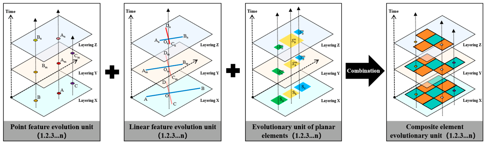
As demonstrated in Figure 5, the fundamental mechanism of multidimensional layered theory is characterized by the dynamic integration and emergence of evolutionary units within a spatiotemporal coupling framework. The spatial axis functions as the foundation, with arrows representing temporal progression driving the iterative deposition of historical elements. Concurrently, evolutionary units comprising point, line, and surface features undergo stacking and aggregation to form composite elements. This process entails the continuous addition of new layers along the temporal axis, accompanied by the restructuring and extension along the spatial axis. The process of analysis entails the compression of abstract temporal sequences into quantifiable spatial cross-sections, thereby materializing dynamic historical phenomena through tangible slices [9].
From an ontological perspective, multidimensional layering transcends the simplistic dichotomy of substance and attribute, subject and object found in traditional ontology, transforming existence into a multifaceted, contextually interwoven whole. In traditional ontology, entities are often defined within a single dimension or a limited number of dimensions. This approach restricts the understanding of existence to a relatively narrow framework. The concept of multidimensional layering reveals existence as a complex state of multidimensional interweaving and layered accumulation. This paradigm shift has led to a shift in perspective, moving from a perception of the internet as an isolated, static entity to a dynamic network constructed from numerous dimensions. This network encompasses levels ranging from the microscopic to the macroscopic, from the material to the spiritual, collectively shaping the essential nature of a thing’s existence [14]. Each dimension endows existence with a unique specificity, permeating and influencing one another. The concept of wholeness, as it pertains to multidimensional layering, cannot be reduced to the mere summation of its constituent elements. Instead, the interaction of each dimension generates entirely new existential characteristics that transcend the sum of any single dimension, greatly expanding the depth and breadth of existence. Within this network, even the slightest shift in any dimension can trigger a chain reaction and a re-layering of the entire structure, thereby altering the state of the whole [15].
At the epistemological level, multidimensional layering does not entail the comprehension of a solitary dimension or uncomplicated causal relationships. In contrast to conventional epistemologies that prioritize the pursuit of certainty and simplicity, seeking to reduce intricate phenomena to a limited number of decisive factors or independent variables through simplification and abstraction, understanding is a multifaceted, comprehensive process. The prevailing paradigm no longer relies on a solitary cognitive pathway or theoretical framework; rather, it necessitates the integration of information, perspectives, and theories from disparate dimensions. The interweaving and mutual supplementation of different dimensions collectively construct a more comprehensive and profound understanding of phenomena. Furthermore, it underscores the dynamic and relative character of cognition. Given the constant interaction and flux inherent to multidimensional layering, cognition itself is a process that is in a constant state of evolution [16]. It is important to note that there are no absolutely fixed cognitive conclusions; instead, understanding is continually revised and refined as each dimension changes. The relationship between the cognitive subject and the cognitive object is no longer a simple reflection and being reflected, but rather a mutual construction through multidimensional interaction. The cognitive structure and capabilities of the subject influence their grasp of the multidimensional aspects of the object, while the multidimensional characteristics of the object prompt the subject to continually adjust and expand their cognitive methods and scope.
At the methodological level, multidimensional layering employs a comprehensive and systematic research approach, emphasizing the dynamic evolution of holistic systems to grasp the interactive, overlapping, and evolving patterns across different dimensions. Conventional research methodologies predominantly emphasize specific domains or dimensions, striving for precision and certainty within a single dimension. Multidimensional layering, however, has been shown to highlight the synergy and mutual influence between dimensions rather than the simple stacking of isolated dimensions [17]. Consequently, the construction of an interdisciplinary, multidimensional research framework is imperative to facilitate a comprehensive analysis and exploration of the subject from multiple angles. The methodology of multidimensional layering prioritizes dynamism and process-oriented approaches [18]. Given that dimensions are in constant interaction and flux, research methods cannot be confined to static, cross-sectional analysis but must instead focus on the developmental evolution of phenomena within the interwoven fabric of multiple dimensions (Figure 6).

3.2. The Difference Between Multidimensional and Low-Dimensional Layering

Multidimensional layering encompasses not only spatial and temporal dimensions but also incorporates additional dimensions, such as social and value dimensions, thereby reflecting the systemic and complex nature of phenomena. Its defining characteristics manifest as an open, multidimensional, networked structure that emphasizes holistic patterns and regularities, along with highly coupled interactions between dimensions, exhibiting nonlinear dynamics and emergent properties [19]. The following distinctions are observed between multidimensional layering and low-dimensional layering.

3.2.1. Complexity and Simplicity

Multidimensional layering is characterized by a high degree of complexity, emphasizing interactions among multiple dimensions and the emergent properties of systems. The system’s core characteristic lies in the dynamic connections between dimensions, thereby enabling the system’s overall performance to far exceed the simple sum of its individual dimensions. This complexity is evident in the nonlinearity and unpredictability of system behavior, where local changes can trigger global effects. In this paradigm, the behavior of complex systems cannot be comprehended or predicted solely through single dimensions or causal relationships. Conversely, low-dimensional layering relies on a limited number of dimensions, employing linear relationships for analysis and inference. This approach simplifies multi-level interactions and connections, rendering it more suitable for relatively simple, stable systems. However, when confronted with dynamic social, cultural, or historical environments, low-dimensional layering frequently falls short of accurately reflecting the diversity and complexity of the system [18].

3.2.2. Holism and Partiality

Multidimensional layering underscores the holistic nature of systems, emphasizing the collective impact of interactions across dimensions. The development of phenomena is an emergent phenomenon that occurs through the cumulative evolution across multiple levels. It is important to note that no single dimension or localized analysis can fully capture the system’s entirety. The holistic approach offers a comprehensive perspective on intricate systems, facilitating researchers’ capacity to discern the hierarchical structures and dynamic evolutionary patterns inherent within these systems. Conversely, low-dimensional layering typically relies on localized analysis, focusing on a single dimension or partial phenomenon. While this approach facilitates addressing specific problems, it often overlooks the influence of other dimensions within the system. Consequently, it fails to clearly reveal the deep connections between phenomena and comprehensively grasp the system’s integrity and evolutionary process [19].

3.2.3. Non-Reductive and Reductive

The non-reductive nature of multidimensional layering is manifest in its systemic behavior and characteristics, which cannot be simply decomposed into independent dimensions or singular causal relationships. The repercussions of disparate dimensions manifest within the ambit of intricately interwoven interactions with other dimensions. Consequently, analyzing any single dimension or factor in isolation often fails to capture its interrelationships and combined impacts with other dimensions, endowing multidimensional layered systems with high complexity and unpredictability. Low-dimensional layering exhibits stronger reducibility, thereby enabling the simplification of complex multi-level relationships into singular causal chains or linear modes [20]. While this method is effective for analyzing relatively straightforward and intuitive phenomena, it often fails to accurately depict the full picture of complex, dynamically evolving systems. Additionally, it is deficient in its failure to adequately reflect the profound and intricate interactions that occur between dimensions, as well as the emergent behaviors that result from these interactions.

3.3. Dimensions and Implications of Multidimensional Layering

3.3.1. The Four Aspects of Multidimensional Layering

(1)
Spatial dimensions: the mutual shaping of urban heritage and spatial structure
The spatial dimension of stratification pertains to the evolution of the physical presence of geospatial and urban heritage over time. The concept of space, understood as the visible manifestation of historical layering, functions not only as a vessel for material heritage and cultural activities but also as a physical witness to historical progression. This spatial dimension encapsulates the accumulation of human activities across various historical periods and their physical traces in urban landscapes, including cities, buildings, public spaces, and other urban elements [7].
The theory of ‘cultural landscape’ proposed by German human geographer Carl Sauer emphasizes that space is not merely a static backdrop; its structure and form reflect the evolution of social life and human activities across historical periods. Space serves as the medium through which historical culture is transmitted, with a variety of cultural and social activities leaving distinct spatial imprints. Consequently, these imprints coalesce to form a multi-layered, multidimensional spatial structure [21]. According to British scholar Peter Hall, urban heritage is not merely a physical landscape; it also bears the historical memory of society and culture. The spatial structures within urban heritage have carried different functions and meanings across various historical periods. Throughout the course of historical evolution, spatial structures have functioned not only as containers for social activities but have undergone their own ‘historical reshaping’ during different eras. According to the French sociologist Henri Lefebvre’s seminal work <The Production of Space>, space is not merely a physically existing geographical backdrop, but rather the outcome of social productive activities. The configuration and arrangement of space are indicative of societal relations of production, power structures, and economic activities. As part of this spatial fabric, urban heritage is not only a remnant of past social productive activities but also a concrete manifestation of those activities and an embodiment of accumulated social history [22].
In the spatial dimension, historical layering underscores the role of urban space as a medium for historical evolution. The evolution of urban landscapes has been shaped by a myriad of social, political, and economic activities across different historical periods, resulting in a multi-layered, multifunctional urban landscape. The transformation of spatial structures not only mirrors the evolution of social, cultural, and economic activities but also shapes the form and function of urban heritage. The spatialization and materialization of urban heritage concretize the interactive processes between history and society, offering a crucial perspective for understanding and researching historical, cultural, and social relationships and their transformations.
(2)
Time dimension: historical layering and nonlinear evolution
Time is not merely a simple linear flow; rather, it is a dynamic, multi-layered, and complex process. In this process, factors such as the socio-cultural landscape, economic activities, and power structures of different eras continuously intertwine and reshape one another along the timeline, thereby forming a multidimensional phenomenon of temporal superposition—historical stratification. Historical stratification is not a linear progression; rather, it is the continuous alternation and superimposition of cultural, political, and economic elements from multiple historical periods at different temporal junctures [23]. The fundamental issue concerning the temporal dimension is that historical advancement does not necessarily entail the complete eradication of past elements. Rather, these elements are often ‘preserved’ and ‘recreated’ within subsequent historical processes. This temporal complexity renders urban heritage not merely a record of the past, but a cultural symbol that transcends time and space.
Fernand Braudel, a prominent figure of the French Annales School, introduced the concept of ‘multiple times’ in his seminal work <The Mediterranean and the Mediterranean World in the Age of Philip II>. He conceptualized historical time as comprising three distinct levels: geographical time, social time, and individual time. He underscored the notion that historical occurrences do not transpire in isolation, but rather emerge as the aggregate outcome of interconnected geographical, economic, and social factors [24]. French philosopher Paul Ricoeur posited that the materialization of time within urban heritage constitutes a vital manifestation of social memory and cultural identity. Each structural layer and remnant within urban heritage materializes the passage of time, serving as a document of the social activities and cultural values of different eras [25]. In his seminal work <A Study of History>, British historian Arnold Toynbee posits that the rise and fall of civilizations does not follow a linear path, but rather an alternating pattern of ‘challenge and response’. This theory underscores the inherent volatility and uncertainty that characterizes history. The decline of certain civilizations is often attributed to specific conditions; however, the influence of their cultural legacy on other civilizations through heritage forms can be a significant factor in the study of nonlinear evolution. The historian Hermann Schwabe has observed that history is not merely a retrospective of the past; rather, it is an ongoing process of interaction between the past and the present. The sedimentation of history is defined as the layered accumulation over time of social experiences, cultural activities, and material legacies from different historical periods [26]. In The Architecture of the City, Aldo Rossi proposes the concept of ‘urban heritage as the solidification of time,’ asserting that its value lies not in the historical significance of any single epoch but in its synthesis across multiple historical phases. The characteristics and legacies of each historical period within this process are often recreated or perpetuated in subsequent historical developments [27]. Therefore, understanding historical landscapes requires more than merely organizing them chronologically; it demands a deeper exploration of the ‘regeneration’ processes across different historical periods, particularly how earlier historical elements are ‘inherited’ and ‘transformed’ to varying degrees within later social practices.
(3)
Value dimension: the multifaceted value attributes of urban heritage
The layered accumulation of value manifests not only as the sedimentation of local history and culture but also reflects the recognition and redefinition of heritage’s multifaceted value within a global perspective. Urban heritage is not merely a physical presence; rather, it functions as a conduit for culture and value. The concept of value encompasses not only the preservation of physical remains but also the social identity, cultural continuity, and emotional memories inextricably linked to urban heritage. The layered dimensions of value explore how historical landscapes acquire distinct cultural and social significance across different eras within the historical accumulation process. These landscapes are continually imbued with new meaning throughout historical evolution.
The value stratum functions as a pivotal theoretical framework for historical heritage studies, underscoring the accumulation of multiple values and their reciprocal influence throughout historical evolution. As Randolph Starn’s research indicates, the value of historical heritage is not static; rather, it undergoes continuous reshaping and redefinition over time. The historical, social, and cultural values of heritage do not exist in isolation; rather, they accumulate and consolidate through ongoing social interactions and cultural recognition within the historical process, forming the multiple layers and depth of the historical landscape [28]. According to the theory of ‘cultural capital’ developed by the French sociologist Pierre Bourdieu, the cultural heritage of a society functions as a form of cultural capital. It possesses not only material value but also generates profound meanings of social recognition and cultural symbols through social interactions. In the process of value accumulation for urban heritage, societal cognition, demands, and historical memory collectively interact, endowing urban heritage with a dynamic and ever-evolving value [29]. The value of urban heritage is not merely the accumulation of material and historical layers but also the outcome of social relations and cultural interactions. Shifts in social cognition and transformations in values enable the renewal and expansion of heritage’s value attributes. As Alfred Gell noted in <Art and Aesthetics>, heritage value reflects not only sociocultural contexts but also the interplay of social forces. From a stratum-based perspective, urban heritage value transcends the material expression of any single historical period, emerging instead as a cultural symbol shaped by multiple historical eras [30]. By examining and understanding this multifaceted value, we can more effectively recognize the importance of preserving diverse urban heritages, thereby respecting their complexity and variety throughout the conservation process.
(4)
Social dimension: the interaction between social forces and historical landscapes
The layered social dimension refers to the continuous accumulation and reconfiguration of historical legacies, cultural landscapes, urban spaces, and other factors at the societal level. The historical period under consideration is inextricably linked to the prevailing social forces, and the evolution of historical landscapes is indicative of social transformation, albeit to varying degrees. It is imperative to recognize that factors such as historical progression, social structures, and cultural identity do not exist in isolation. Instead, they are intricately interwoven through social relationships, interactions, and power structures, collectively shaping and defining the multifaceted meanings of heritage. The layered social dimension underscores the notion that heritage is not merely a physical and cultural deposit, but also a reflection of social change, cultural identity, and power relations [31].
Sociologist Pierre Bourdieu’s theory of ‘social fields’ emphasizes that social space is not static but is jointly shaped by different social groups through interaction and competition. Therefore, the stratification of urban historical landscapes is not merely a simple accumulation of physical layers. Rather, it reflects how various social groups, under specific historical conditions, influence and mold the appearance and function of urban space through their behaviors, power dynamics, and capital operations [32]. Historical stratification is not only an accumulation of space and time but also a historical process of social actions and cultural practices. Helmut Kreuzer, in his research on urban heritage preservation, argues that the value of urban heritage is not inherently fixed but is progressively constructed through the interaction of social practices and political forces. Every site, every street, and every building in a city bears the social, political, and cultural imprints of different historical periods. For specific social groups, buildings are not only witnesses to history but also symbols of identity and cultural transmission. Therefore, heritage preservation is not merely about safeguarding physical structures; it is also about respecting and perpetuating social history. Changes in social structures and the dynamics of social forces directly influence the value and meaning of historical heritage. Hall Oster argues that the social significance of urban heritage largely stems from its function as collective memory. Historical heritage encompasses not only physical structures or landscapes but also carries society’s collective memory and emotional attachment to the past. French philosopher Michel Foucault’s theory of power highlights the intimate connection between history and power dynamics. Power manifests not only through political systems and legal frameworks but also through the norms and practices embedded in everyday social life [33]. His ‘disciplinary society’ theory provides a framework for understanding how urban heritage is shaped by social power structures. Across diverse historical contexts, social and political power shapes the meaning and value of heritage through its designation and control. Thus, the layering of the social dimension represents not merely material accumulation, but the sedimentation of social history, cultural identity, and power relations [34].
(5)
The couplings between the four dimensions
The four dimensions—time, space, society, and value—are not parallel, mutually independent analytical units, but rather constitute a continuous mechanism underlying the stratification and evolution of the historical urban landscape. Among these, the temporal and spatial dimensions form the foundational dimensions of the historical urban landscape, embodying the ways in which historical processes are deposited within the city’s physical environment; The social dimension serves as the dynamic mechanism linking spatiotemporal evolution with the generation of heritage significance, revealing how social actors, institutional forces, economic activities, and cultural practices at different historical stages intervene in and reshape urban space; the value dimension, meanwhile, constitutes the cognitive outcomes and evaluative systems formed on the basis of spatiotemporal accumulation and social interaction, reflecting the ways in which historical landscapes are understood, interpreted, recognized, and utilized across different periods. An intrinsic causal chain exists among these four dimensions, extending from “spatio-temporal processes” to “social practices” and then to “value construction.” Simultaneously, value perceptions exert a reciprocal influence on social actions and spatial renewal, forming a continuous, cyclical process of historical stratification [35].
The temporal dimension first and foremost determines that the formation of a city’s historical landscape is characterized by continuity, phased development, and non-linearity. The political systems, modes of production, lifestyles, and cultural concepts of different historical periods do not disappear entirely over time; rather, they enter subsequent historical processes through preservation, overlay, translation, rupture, or regeneration. The stratification of time provides historical depth to urban space, transforming it from a static outcome of a single era into a complex entity shaped by the combined effects of multiple historical processes. The spatial dimension, in turn, serves as the material expression of this temporal stratification. Historical processes must manifest through concrete spatial elements such as street patterns, architectural forms, land use, public spaces, infrastructure, and landscape nodes. While time provides the vertical thread of historical evolution, space offers the visible vessel for this evolution; together, they constitute the material foundation of the historical urban landscape.
The social dimension is not an external factor parallel to the spatio-temporal dimension, but rather a key mechanism driving spatio-temporal transformation. Urban spaces change not merely due to the passage of natural time, but because social actors across different eras continuously produce, occupy, use, and reinterpret these spaces under specific institutional, political, economic, and cultural conditions. Government governance, religious organizations, commercial capital, local communities, professional institutions, and everyday practices all intervene in the historical landscape through planning and construction, property rights adjustments, functional transformations, ritual activities, memory narratives, and conservation efforts. These interventions cause certain historical layers to be perpetuated, reinforced, or displayed, while others are obscured, replaced, or forgotten. The social dimension is the key to explaining “why certain spatial forms are preserved, why certain historical memories are perpetuated, and why the significance of certain heritage sites is highlighted.”
Value dimensions are the result of the combined effects of historical accumulation, spatial manifestation, and social practice. The value of urban heritage is not inherently fixed within physical remains, but rather emerges through a process in which society continuously identifies, selects, and ascribes meaning to these elements across different historical periods. A particular building, neighborhood, or landscape element may initially serve a utilitarian function primarily, but subsequently acquire historical, cultural, social, artistic, scientific, or economic value as it becomes associated with significant historical events, local memory, identity, aesthetic experiences, or economic development. Value is not an abstract judgment independent of time, space, and society, but rather a construction of meaning carried out by social actors based on existing temporal and spatial remnants. Differences in value perceptions among various actors also lead to differing choices in heritage conservation, revitalization, and spatial governance.
This causal relationship is not a unidirectional, linear process, but rather one characterized by feedback and cyclicality. Established perceptions of value further influence social actions—such as heritage identification, conservation planning, tourism development, community participation, and cultural exhibitions—which, in turn, alter the state of preservation, modes of use, and symbolic significance of urban spaces. These actions ultimately become new layers of historical accumulation, entering the next cycle of temporal evolution. Therefore, in the comprehensive assessment of historic urban landscapes, the four dimensions should be situated within an analytical framework characterized by intrinsic logical relationships: the temporal dimension addresses “how historical processes accumulate”; the spatial dimension addresses “how historical processes materialize and manifest”; the social dimension addresses “which actors and forces drive spatial changes and shifts in meaning”; and the value dimension addresses “why these temporal and spatial legacies are important, to whom they are important, and how they are reinterpreted and utilized by contemporary society.”
(6)
Application pathways across four dimensions
In the comprehensive assessment of historic urban landscapes, although the four dimensions—time, space, society, and value—collectively form the framework for stratigraphic analysis, their modes of presentation and evaluation pathways differ in practice. Among these, the temporal and spatial dimensions possess strong visual characteristics and can be intuitively represented through methods such as historical map overlay, urban form analysis, spatial distribution of heritage sites, identification of building eras, evolution of street and alley patterns, changes in land use, and landscape visual corridor analysis. The temporal and spatial dimensions can be relatively directly translated into layers, coordinates, boundaries, paths, patches, nodes, and morphological relationships, making them the aspects of historical urban landscape stratigraphic analysis that are easiest to present spatially and visually [36].
In contrast, the social and value dimensions are characterized by a high degree of implicitness, relationality, and interpretive complexity. The social dimension encompasses social actors, community relations, daily use, collective memory, local identity, governance structures, power relations, and stakeholder interests; the value dimension involves multiple assessments, including historical, cultural, social, aesthetic, scientific, economic, and contemporary utility values. These elements are not always directly discernible from the morphological features of urban space. In practical assessments, the social and value dimensions typically require the development of specialized indicator systems, employing a combination of qualitative and quantitative methods for identification, measurement, and interpretation.
At the operational level, the spatio-temporal dimension can serve as the foundational framework for assessing social and value dimensions. First, a spatio-temporal database of historical urban landscapes can be established using historical maps, current surveys, remote sensing imagery, cadastral data, building censuses, and urban form analysis to identify the spatial distribution, evolutionary trajectories, and stratigraphic intensity of heritage elements from different historical periods. Second, using blocks, plots, buildings, streets, alleys, public spaces, or landscape units as basic evaluation units, social and value indicators can be embedded within specific spatial objects [37]. For example, within the same historic district, different buildings may share similar ages and stylistic characteristics, yet exhibit significant variations in social usage intensity, community identification, public accessibility, frequency of cultural activities, and potential for conservation and utilization. Similarly, certain spatial remnants, despite having only moderate physical preservation, may possess high social value due to their role in carrying important local memories, folk activities, or group identity. In such cases, relying solely on spatiotemporal visualization cannot fully reveal their heritage significance; it must be supplemented by social and value indicators.
The indicator systems for the social and value dimensions should be established at the level of spatiotemporal units and correlated with spatial data. For the social dimension, indicators can be developed with a focus on aspects such as stakeholder participation, daily use, community identity, social memory, publicness, stakeholder relationships, and governance participation. For the value dimension, indicators can be developed based on aspects such as historical value, artistic and aesthetic value, scientific research value, cultural symbolic value, social value, economic utility value, and sustainable development value. Through methods such as questionnaire surveys, in-depth interviews, public participation, analysis of literature and archives, expert evaluations, behavioral observation, online text analysis, and spatial big data analysis, previously implicit social relationships and value judgments can be transformed into evaluation results that are comparable, interpretable, and spatially expressible.

3.3.2. The Five Dimensions of Multidimensional Layering

As articulated by the World Heritage Convention, authenticity should encompass ‘form and design, materials and substance, use and function, tradition and technology, location and setting, spirit and sentiment, and other intrinsic or extrinsic factors, including historical, artistic, archaeological, or cultural value.’ Authenticity, a fundamental aspect of heritage preservation, entails maintaining a form that is consistent with its original state to the greatest extent possible, thereby preserving its historical, cultural, and social context. Authenticity is defined by two components: the faithful preservation of physical remains and the respect for and transmission of historical processes and cultural significance. In his theory of ‘social sculpture’, Joseph Beuys underscored the inherent interconnectedness between art and society, asserting that the pursuit of authenticity ought to encompass not solely the material form but also the conveyance of cultural significance and the reconstruction of social value [38]. The authenticity of heritage is contingent upon the respect it engenders for its multidimensional nature, which is gradually revealed through historical stratification. This process unveils the unique value and significance of each historical phase, thereby fostering a comprehensive understanding of its complexity and richness. Stratigraphic authenticity is defined as the degree to which historical heritage accurately reflects the cultural characteristics, social transformations, and spatial forms of each historical period within its multi-layered, multidimensional accumulation process [39]. Authenticity, therefore, extends beyond the mere physical preservation of historical heritage to encompass the faithful representation of its historical value, cultural significance, and social context. The concept of historical heritage is not static; rather, it undergoes multiple layers of accumulation and transformation over extended periods of development and evolution. Each stratum of historical sedimentation authentically reflects distinct historical eras. The concept of stratigraphic authenticity underscores the imperative to honor and preserve the distinct characteristics of each historical period. It is essential to prevent modernization processes from distorting or oversimplifying historical features and cultural significations. This approach is predicated on the principle of preserving the heritage entity itself and recreating its historical context with precision [40].
The term ‘integrity’ is employed to denote the wholeness of natural or cultural heritage and its defining characteristics. The concept of stratigraphic integrity underscores the notion that historical heritage should be regarded as a cohesive entity that persists throughout the process of its accumulation and evolution across historical periods. This concept encompasses not only the physical record of history but also the collective accumulation of diverse cultural and social factors from different eras and societal contexts. This holistic nature of historical heritage across temporal and spatial dimensions is reflected in the comprehensive nature of the concept. The scope of heritage conservation encompasses not only physical restoration but also the prioritization of historical integrity and cultural context. Consequently, the concept of layered integrity necessitates a holistic approach to comprehending the multifaceted cultural attributes and social functions of historical heritage. This approach precludes oversimplified or partial ‘restoration’ or ‘reconstruction’. A comprehensive consideration of the impacts of various historical periods is necessary, as is respect for the interweaving of diverse cultural and social factors. The objective is to present a comprehensive and complete historical landscape [41].
The concept of continuity is not static; rather, it is a multi-layered, complex, ongoing evolution. The concept of stratified continuity in historical studies refers to the continuity and gradual progression of historical legacies across different historical phases. This concept emphasises the ‘temporal depth’ of such legacies, suggesting that they extend over a considerable duration. This suggests that historical legacies must not only preserve their present form, but also reflect their evolution and transmission throughout the historical continuum. Jürgen Habermas’s theory of the public sphere posits that the continuity of historical heritage constitutes a dynamic process of historical social construction. This demonstrates how historical heritage maintains its continuity and achieves ongoing cultural transmission through the interplay of social structures and cultural practices [42]. Therefore, the presence of stratigraphic continuity is of paramount importance in ensuring the preservation of cultural, historical and social functions in the context of societal transformation. It is imperative that the values of the past are not merely replicated, but that they are also able to be transmitted and empowered within new historical contexts.
The concept of adaptability, as initially theorised by Darwin in his study of evolution, signifies the progressive adjustment and coordination of organisms with their environment through the process of natural selection over an extended period. In Adaptation to Environment, Lawrence Henderson proposed that ‘an organism’s response to its natural environment drives its evolution towards adaptation to that environment, establishing a relationship of holistic coordination and mutual adaptation between organism and environment.’ This encompasses not only the organism’s adaptation to the environment, but also the environment’s reciprocal adaptation to the organism, constituting a bidirectional adaptation and holistic coordination relationship [43]. The concept of stratified adaptability signifies the continuous process of adapting to symbiotic environments, encompassing various dimensions such as time, geography, culture, architecture, function, community, economics, and society. This process is characterised by the achievement of holistic coordination through mutual adaptation and dynamic transformation. This concept encapsulates variability and adaptability across a range of historical contexts and social conditions. In accordance with Anthony Giddens’s structuration theory, the adaptability of heritage facilitates its ability to fulfil unique social functions throughout historical evolution. This is achieved through the continuous shaping of social structures and the constant innovation of social practices [44]. The concept of adaptive reuse underscores the manner in which historical heritage assimilates into present-day life within novel social and cultural milieus, thereby undergoing a transformation in its cultural significance and social functions through physical preservation. As Jane Jacobs observed in her seminal work <The Death and Life of Great American Cities>, the adaptive reuse of urban heritage is characterised by the reallocation of social, cultural, and economic functions during the process of modernisation [45]. Adaptive stratification facilitates the ongoing fulfilment of cultural value and social roles within new societal contexts by enabling interaction and transformation with modern society.
The term ‘dynamics’ is employed to denote the inherent property of a system being perpetually in a state of motion and development. The dynamics of urban stratification are defined by the characteristic of urban space undergoing continuous change, evolution, and transformation across both temporal and spatial dimensions. Carl Böhret’s theory of ‘historical transformation’ emphasises that historical heritage must reflect not only the static existence of history but also its dynamic processes and mechanisms of change. Immanuel Wallerstein proposes that urban space, as a consequence of socio-historical forces, undergoes transformation across different historical periods, continually reshaped and regenerated through social, economic, and political dynamics [46]. The dynamic nature of stratification implies that urban spatial transformations are not accidental but inevitable outcomes of temporal development. Furthermore, historical heritage is not static; it is subject to continuous alteration and renewal across historical periods, reflecting both socio-cultural contexts and the consequences of historical change. This dynamic stratification underscores the importance of focusing on the evolutionary processes and historical trajectories of heritage in order to ensure its effective research and conservation. In order to achieve this end, the developmental pathways, mechanisms of change, and intrinsic driving forces must be analysed.

3.4. A Multidimensional Layering Approach for Constructing the Evolution of HUL

The HUL perspective emphasizes the continuity and integrity of historic urban areas across temporal and spatial dimensions. In contrast, the ‘multidimensional layering’ theory provides a structured analytical framework integrating multiple elements, including historical layering components, spatial patterns, and functional evolution. The integration of these approaches not only addresses the limitations of ‘element fragmentation’ in conventional historic urban landscape conservation but also provides a methodological framework for establishing dynamic, systematic preservation mechanisms. Research on historic urban landscape encompasses a variety of academic disciplines, including architecture, planning, history, human geography, sociology, and culture. The formation, evolution, and preservation of these elements are a multi-layered, complex process. Conventional analytical methodologies frequently depend on a limited number of dimensions, thereby encountering difficulties in comprehensively elucidating the heterogeneity and evolving nature of historic districts. The multidimensional layering approach is a systematic analytical tool that enables in-depth analysis of the complex characteristics of historical urban landscapes. This method comprehensively considers the interactions and accumulations across multiple dimensions [47].

3.4.1. Method Applicability Analysis

(1)
Multiple documentation of historical urban landscapes
Layering itself constitutes a multifaceted record of historical space, revealing the cumulative processes of social, cultural, and economic factors across distinct historical periods. This multidimensional layering has been demonstrated to be an effective corrective measure for the longstanding ‘narrow-vision syndrome’ that is prevalent within the field of heritage studies. Previous approaches, with an excessive focus on singular historical periods, have frequently resulted in the loss of valuable historical information and the disruption of cultural transmission chains. The comprehensive coverage of the entire historical continuum is achieved by multidimensional layering, which preserves the unique imprints of each stage and restores urban historical landscape research to its richly diverse authenticity. Concurrently, it meticulously delineates the intricate texture of historical transformation [48]. The concept of continuity is manifested through the persistence of living customs and the transmission of fundamental construction techniques across generations. In contrast, distinct phases emerge through societal transformations and cultural innovations catalysed by major historical junctures. This approach constructs a platform spanning both material entities and socio-cultural structures.
(2)
Systematic construction of cultural landscape sequences
Multidimensional layering provides a groundbreaking perspective for the scientific and systematic construction of cultural sequences. It facilitates the precise mapping of historical, cultural and societal relationships within specific historical periods, organically integrating them into a coherent and hierarchically ordered cultural framework through the continuous sedimentation and evolution of temporal elements. Employing multidimensional stratification analysis for in-depth exploration, it deconstructs the sequence of the cultural timeline, clarifying the intrinsic connections and distinct differences across various historical phases in terms of cultural transmission and evolution [49]. By analysing the trajectories of diverse elements, it is possible to precisely identify core cultural factors that transcend time, persist to the present day, and retain their vitality, alongside those that have gradually waned or undergone qualitative transformations throughout historical evolution.
(3)
Revealing the complexity of multidimensional interactions
The multi-dimensional layered approach has been demonstrated to reveal the interactive relationship between the spatial patterns of the built environment and regional cultural context dimensions. Furthermore, it has been shown to construct a cognitive framework for understanding the urban historical landscape as a complex system. The evolution of architectural styles within urban historical landscapes is driven by a combination of shifts in social structures, economic development, and the introduction of external cultural influences. In comparison with conventional single-dimensional analyses that have the potential to overlook interactions between elements, multidimensional layered analysis facilitates a more profound comprehension of how each dimension influences urban character. The approach under discussion here succeeds in capturing the complex features accumulated across different historical phases, thereby avoiding the analytical biases inherent in single-perspective approaches [50].
(4)
Analysing the Dynamic Evolution of Historical Landscapes
The formation and development of historical urban landscapes is a long-term process of accumulation, involving transformations across multiple historical periods. The multi-dimensional layering approach emphasises the dynamic nature of systems and the layering process, revealing the patterns of change across different dimensions during historical evolution. In the interpretation of the evolution of urban historical landscapes, the focus is directed not solely towards the static characteristics of a specific period, but also towards the cumulative and evolutionary processes that occur across different historical stages. Through multidimensional analysis of urban historical landscapes at distinct temporal junctures, it is possible to discern the dynamic interrelationships within neighbourhoods concerning architectural styles, landscape characteristics, functional shifts, and social structural evolution. This approach unveils the manner in which such transformations interact within the holistic system to shape the distinctive character of urban historical landscapes. Consequently, it clarifies which morphological features endure over the long term and which are products of specific eras, thereby furnishing a multidimensional dynamic analytical framework for the evolution of historical urban landscapes [51].
(5)
Decision support for protection and renewal
The conservation and regeneration of urban historical landscapes extends beyond the preservation of architectural character, encompassing the balancing of historical value against contemporary demands and the resolution of conflicts between multicultural contexts and local traditions. The multi-dimensional layered approach proffers scientific decision support for the conservation and regeneration of urban historical landscapes, thereby addressing the question of how to preserve their historical and cultural value while meeting the demands of contemporary urban development. It is evident that, by comprehensively considering the various dimensions, analysing the potential impacts of different conservation measures and identifying possible optimisation pathways, the interrelationships between these dimensions are fully recognised. This ensures harmonious coexistence across all dimensions, thereby proposing more rational conservation strategies [52].

3.4.2. Path Construction of Multidimensional Layering

The multidimensional layering analysis pathway for historical urban landscapes constitutes a complete chain encompassing ‘layering elements—layering processes—layering patterns—layering modes—layering drivers—layering characteristics’. This framework encompasses progressive relationships from concrete to abstract, dynamic to static, and partial to holistic.
(1)
Stratigraphic elements are the basic units within an urban historical landscape that can be identified, documented, measured, and interpreted; they serve as the starting point for multidimensional stratigraphic analysis. Unlike general urban spatial analysis, the elements of an urban historical landscape are not limited to physical remains but encompass multiple components, including the natural substrate, the built environment, spatial structure, social activities, and cultural values. Stratified elements can be categorized as follows: First, natural environmental elements, such as topography, mountains, water systems, vegetation, and climatic conditions, which constitute the natural foundation for the formation of the urban historical landscape; second, physical spatial elements, such as city wall ruins, street and alley patterns, block textures, historic buildings, traditional courtyards, bridges, docks, squares, public spaces, and landscape nodes, which serve as the most intuitive spatial carriers of historical stratification; Third, functional and activity elements, such as historical functions—including residential, commercial, artisanal, religious, administrative, defensive, transportation, and public interaction—and their contemporary continuations; fourth, socio-cultural elements, such as local customs, festive activities, folk beliefs, occupational traditions, historical events, memories of notable figures, and community identity; Fifth are value-perception elements, such as historical value, artistic value, social value, cultural symbolic value, landscape aesthetic value, and contemporary utility value. These layered elements embody the holistic characteristics of the urban historical landscape. HUL is not composed of a single heritage type, but rather a composite system formed by the interplay of natural, spatial, social, and cultural values. These elements exist both as independent entities and as an interconnected network.
(2)
The process of stratification refers to the dynamic process in which various stratification elements are continuously generated, superimposed, replaced, integrated, decayed, and regenerated over time and across space. The historical landscape of a city is not the result of a one-time formation during a specific historical period, but rather a comprehensive landscape form that has gradually emerged through continuous evolution across different historical stages. From a temporal perspective, the stratification process manifests as continuity, discontinuity, and reconstruction across different historical phases. For example, a historic district may simultaneously preserve traditional street patterns, modern commercial buildings, contemporary infrastructure, and modern cultural consumption spaces. These elements from different periods are not simply juxtaposed but have been superimposed and reorganized through long-term evolution. From a spatial perspective, the process of stratification manifests as the continuous adjustment of urban patterns, street systems, block organization, architectural forms, and public spaces. From a social perspective, it is reflected in the practices of use, governance, transformation, and memory carried out by various social actors within the urban space. From a value perspective, it manifests as the continuous generation, translation, and redefinition of the historical landscape’s significance. The process of stratification concentrates the layered and dynamic nature of the urban historical landscape. The focus is not merely on explaining “what has been preserved,” but rather on elucidating “how these elements were formed, how they changed, and how they were sustained or replaced.” The stratification process represents the trajectory from single elements to a multifaceted, composite landscape; it also serves as the foundation for understanding the temporal depth, spatial evolution, and social continuity of the urban historical landscape [53].
(3)
The principle of stratification is a generalization and summary of the stratification process in urban historical landscapes. It refers to the relatively stable organizational relationships, modes of superposition, and spatial manifestations formed by various elements through long-term evolution. It reflects the unique evolutionary paths of urban historical landscapes and reveals how diverse elements integrate into recognizable landscape structures within specific environments. In urban historical landscapes, the laws of stratification typically manifest in the following categories: First, the law of spatial continuity, wherein historical alleys, axes, water systems, city walls, boundaries, or traditional blocks continue to influence urban form during subsequent development; second, the law of functional substitution, wherein the original spatial form is retained but its functional use changes—for example, traditional residential buildings are transformed into commercial, exhibition, or cultural consumption spaces; third, the pattern of morphological nesting, wherein buildings, streets, and public spaces from different historical periods coexist and intertwine within the same area; fourth, the pattern of value regeneration, wherein spaces originally used for ordinary production, daily life, or transportation are re-identified in the contemporary era as heritage spaces possessing historical, cultural, or social value; and fifth, the pattern of social memory continuity, wherein certain spaces maintain stable cultural significance by continuously embodying collective memory, local customs, or community identity [54].
(4)
Stratification patterns represent a further abstraction of evolutionary types and common logical principles derived from the laws of stratification. While these laws primarily reflect the evolutionary characteristics of specific cities or neighborhoods, patterns emphasize the universal structural elements that may recur across the historical landscapes of different cities. Stratification patterns can be categorized into several typical types. First is the continuity-based stratification pattern, in which the historical spatial layout, street fabric, and functional structure remain relatively stable over the long term, with subsequent development primarily manifesting as incremental renewal; second is the superimposition-based stratification pattern, in which architecture, functions, and cultural significance from different periods are layered upon one another within the same area, forming a composite landscape where multiple eras coexist; Third is the substitution-type stratification pattern, in which original spatial elements are partially or entirely replaced by new ones, yet retain certain historical traces or spatial memories; fourth is the embedding-type stratification pattern, in which new urban functions, infrastructure, or landscape nodes are embedded within existing historical spaces, creating a symbiotic relationship between the old and the new; fifth is the regeneration-type stratification pattern, in which historical remnants are reactivated through preservation, exhibition, renewal, and cultural utilization, thereby acquiring new social functions and value.
(5)
Cumulative factors are the fundamental forces driving the emergence, transformation, and reproduction of urban historical landscapes. The formation of urban historical landscapes is not a spontaneous process but rather the result of continuous evolution driven by the combined influence of various factors, including the natural environment, political systems, economic structures, social needs, cultural concepts, and technological conditions. From the perspective of external conditions, factors such as the natural geographical environment, regional transportation networks, military defense requirements, changes in administrative systems, industrial development, urban planning, and modernization efforts all profoundly influence the spatial organization and evolutionary trajectory of urban historical landscapes [55]. From the perspective of internal mechanisms, residents’ lifestyles, community relations, local beliefs, cultural traditions, property rights structures, commercial activities, and daily use continuously influence the preservation, transformation, and reuse of historical spaces. Furthermore, contemporary heritage conservation policies, tourism development, capital investment, and public participation also serve as new cumulative drivers, causing historical urban landscapes to be constantly reshaped through a balance of preservation and renewal.
(6)
The characteristics of stratification are the comprehensive result of the combined effects of stratification elements, processes, patterns, and driving forces; they represent the concentrated manifestation of what distinguishes the urban historical landscape from general urban spaces and individual heritage sites. These characteristics manifest not only as visible spatial forms but also as implicit social relationships, cultural memories, and values. Spatially, layered characteristics manifest as the continuity of the city’s historical layout, the complexity of street and alley patterns, the mix of architectural eras, the multifunctionality of public spaces, and the holistic interconnection between the natural and built environments. Temporally, they manifest as the coexistence, discontinuity, continuity, and regeneration across different historical periods. Socially, they manifest as the ongoing engagement of residents’ daily lives, local commerce, cultural activities, community identity, and governance practices with the historical landscape. In terms of value, the characteristics of stratification manifest as the multi-layered integration of historical, cultural, social, aesthetic, economic, and sustainable development values. These characteristics are not a simple summary of the aforementioned elements, but rather a comprehensive distillation of the unique attributes of the urban historical landscape. Ultimately, this addresses the core questions of HUL research: namely, how urban historical landscapes are formed through long-term historical evolution, how they are manifested through spatial forms, how they continue to play a role in contemporary social life, and why they possess irreplaceable value for both conservation and utilization [56].
The layering of historical urban landscapes is a dialectically unified system of dynamic interrelationships, encompassing multiple dimensions including ‘elements, processes, patterns, modes, drivers, and characteristics’. Each dimension functions as an independent component while concurrently contributing to a complex whole through interconnectedness, interaction, and evolution. In summary, each dimension of this multidimensional layering is both an autonomous part and, through mutual connection, interaction, and transformation, contributes to a complex integrated system. Layering drivers are the impetus for stratification phenomena. Layering elements serve as a concrete carrier for these drivers. Layering processes manifest the superposition and transformation of elements. Layering laws reveal universal patterns within these processes. Layering patterns encapsulate the intrinsic logic of these laws, while layering characteristics represent their comprehensive manifestation [57].

3.5. Case Study

3.5.1. Overview of Shenyang’s Historic District

Shenyang is a renowned historical and cultural city in China and a major central city in Northeast China. Its historic district is not a single, contiguous traditional old town, but rather consists of four core areas formed during different historical periods, driven by different factors, and characterized by distinct spatial typologies: the Shengjing City Area, the Manchurian Railway Concession Area, the Commercial Port Area, and the Tiexi Industrial Area. Each of these four districts possesses distinct spatial boundaries, unique historical origins, and distinctive landscape characteristics, collectively forming the most representative core areas of Shenyang’s urban historical landscape.
(1)
Shengjing city area
The Shengjing City District is bounded by Dongbiancheng Street to the east, Nanguan Road to the south, Qingnian Avenue to the west, and Huigong Street to the north, covering an area of approximately 14.2 square kilometers. This district marks the origin of Shenyang’s urban development and served as the former capital of the Qing Dynasty, as well as the best-preserved traditional capital city in Northeast China. The Shenyang Imperial Palace, the historical layout of Shengjing City, the traditional commercial district of Zhongjie, the Zhang Family Mansion, and modern financial and religious buildings are all concentrated here. The Shengjing City District holds significant value in the study of traditional Chinese capital construction as well as in the history of the Qing Dynasty and modern development. It is the core area of Shenyang’s urban historical landscape, possessing the greatest historical depth and cultural symbolism (Figure 7).
(2)
The south Manchuria railway settlement area
The South Manchuria Railway Enclave is bounded by Heping Street to the east, South 5th Road to the south, the Changda Railway to the west, and North 7th Road to the north, covering an area of approximately 4.0 square kilometers. This area is a landmark of Shenyang’s modern urban development and was the city’s first district to undergo comprehensive planning and design. It is home to a concentration of modern railway station areas, commercial spaces along Taiyuan Street, colonial-era urban planning layouts, and public buildings, making it of significant value for the study of Shenyang’s modern history and its urban economic and social development. The South Manchuria Railway Annex Area exemplifies the profound influence of modern transportation technology, colonial planning concepts, and modern urban lifestyles on Shenyang’s urban spatial structure (Figure 8).
(3)
Commercial Port Area
The Commercial Port Area is bounded by Qingnian Street to the east, Shisanwei Road to the south, Heping Street to the west, and Shifu Avenue to the north, covering an area of approximately 3.4 square kilometers. This district served as Shenyang’s primary gateway for external exchanges from the late Qing Dynasty through the Republican era, and it is also where the mansions and former residences of prominent figures from modern times are primarily concentrated. The development of the Commercial Port Area is closely linked to the opening of trade and commerce, diplomatic exchanges, and the gathering of the social elite in Northeast China during the modern era. Its spatial layout, architectural character, and memories of social life collectively constitute an important historical testament to Shenyang’s modern urban social transformation and external exchanges (Figure 9).
(4)
Tiexi Industrial Area
The Tiexi Industrial Area is bounded by Jingxing North Street to the east, North 3rd Road to the south, the existing road to the west, and North 1st Road to the north, covering an area of approximately 3.5 square kilometers. This area contains the highest concentration of existing industrial sites and the richest variety of industrial heritage within the historic Tiexi Industrial Zone, preserving its traditional urban fabric and character. The Tiexi Industrial Zone serves as a vital spatial embodiment of Shenyang’s status as the “eldest son of the Republic’s industry.” It carries the collective memory of New China’s industrialization, the lives of workers in their communities, and socialist industrial culture, standing as a central testament to Shenyang’s modern industrial development (Figure 10).

3.5.2. Historical Landscape Characteristics of Shenyang’s Historic District

(1)
A spatial layout featuring multiple sources arranged side by side
Unlike many historic and cultural cities, which have a single core centered on a traditional old town, Shenyang’s historic district is composed of four distinct types of urban spaces: the traditional imperial capital, the colonial planning zone, the commercial and trade zone, and the industrial production zone. These four types of spaces emerged from different historical contexts, development motivations, and planning philosophies, forming a complex urban fabric characterized by the coexistence of multiple centers, diverse types, and varied textures. This spatial composition itself serves as a vivid illustration of the layered nature of the city’s historical landscape.
(2)
A temporal depth spanning multiple historical periods
The formation of Shenyang’s historic urban area spans multiple historical phases, including the development of a military town during the Ming Dynasty, the construction of the imperial capital in the early Qing Dynasty, the growth of a secondary capital during the Qing Dynasty, modern-era colonial and commercial expansion, industrialization in the People’s Republic of China, and contemporary urban renewal. Each of these phases has left its own physical traces and social memories within the urban landscape, coexisting through processes of superimposition, juxtaposition, embedding, and reuse.
(3)
Distinctive characteristics of dynamic continuity
Shenyang’s historic district is not a museum-like exhibition space; rather, it continues to serve a wide range of urban functions and support social life. Zhongjie retains the vitality of a traditional commercial hub, while Taiyuan Street maintains the retail functions of a modern commercial district. Some of the modern buildings within the Shangbu area are still used as offices, cultural, and residential spaces, and the Tiexi Industrial Zone is currently undergoing a transformation from industrial production to cultural and creative industries and urban renewal.
(4)
A multifaceted meaning woven from multiple values
Shenyang’s historic district holds significance in terms of research on traditional Chinese capital cities, Qing dynasty politics and culture, modern colonial history and urban planning, commercial openness and social transformation, industrial heritage and memories of socialist construction, as well as contemporary urban renewal and sustainable development. These values do not exist in isolation but are interwoven across different districts, spaces, and social groups.
(5)
The complex reality of the intertwined contradictions between conservation and development
The Shengjing City area faces a tension between preserving its historical character and commercial tourism development; the Manchurian Railway Concession area involves issues of historical perception and contemporary value judgments regarding colonial heritage; in the Shangbu area, the level of protection for some modern buildings is insufficient; and the Tiexi Industrial Zone faces practical challenges such as the limited range of options for reusing industrial heritage and the fading memories of the working-class community. These issues precisely call for a multidimensional, layered approach.

3.5.3. Analysis Based on the Multidimensional Lattice Method

(1)
Layering factors
The historical district of Shenyang is rich in layered elements, encompassing a wide range of categories such as the natural environment, spatial forms, architectural heritage, functional activities, socio-cultural aspects, and perceptions of value. Each of the four sub-districts contributes distinct types of layered elements, collectively forming a multidimensional system of elements that defines the city’s historical landscape.
In terms of natural environmental factors, the Hun River serves as the most important natural foundation for the formation of Shenyang, influencing the selection of early settlement sites, the spatial development of the city, and the shaping of modern waterfront spaces. The Shengjing City area features flat terrain, which facilitated the development of the capital’s layout; conversely, the location of the Tiexi Industrial Zone was closely tied to the requirements of railway lines and industrial land for flat terrain.
In terms of spatial form, the Shengjing City area retains a relatively distinct memory of the traditional city site, a “well” pattern of streets and alleys, and a square city layout. The Shenyang Imperial Palace and its palace grounds, Zhongjie Street and the traditional commercial streets and alleys on either side, the Zhang Family Mansion and the surrounding modern architectural complex, as well as traditional siheyuan courtyards and the historical fabric of the area, constitute the core spatial elements of this district. The South Manchuria Railway Concession area is primarily defined by its modern grid-like road network, railway station precinct, the Taiyuan Street commercial axis, and public buildings from the colonial era. The Commercial District area features a modern planning layout structured around the Weilu and Jinglu roads, with notable residences of prominent figures, historic homes, and modern public buildings distributed throughout. The Tiexi Industrial Zone area is characterized by industrial plants, dedicated railway lines, workers’ residential areas, and production-oriented public spaces.
In terms of architectural heritage, the four districts are home to a large concentration of historical buildings of various types. The Shengjing City area includes the Shenyang Imperial Palace (a UNESCO World Heritage Site), the Zhang Family Mansion, the Former Residence of Zhao Yidi, the Bianye Bank, Zhongshan Square and its surrounding modern buildings, Shisheng Temple, Chang’an Temple, Taiqing Palace, and the Catholic Church. The South Manchuria Railway Concession area includes Shenyang Station, the former Fengtian Railway Station, the former Japanese Consulate, the South Manchuria Railway Fengtian Office, and modern commercial buildings on Taiyuan Street. The Commercial District includes the Yang Yuting Mansion, the Chang Yinhui Mansion, the Sun Yat-sen Square complex, and several other modern mansions and residences. The Tiexi Industrial Zone includes industrial heritage sites such as the Shenyang Foundry, Smelter, and Machine Tool Factory, as well as the Workers’ Village residential area.
In terms of functional and activity elements, Zhongjie has retained its role as a traditional commercial center to this day, while Taiyuan Street continues to serve as a hub for modern commercial and consumer activities. The Zhang Family Mansion and the Shenyang Imperial Palace have been transformed into museums and key tourist attractions, and some of the modern buildings in the Shangbu area now serve as office and cultural spaces. Meanwhile, industrial buildings in the Tiexi area are undergoing a transformation to accommodate cultural, creative, and exhibition uses. At the same time, social functions such as daily life, community interaction, religious activities, and festivals continue to thrive within each district.
In terms of socio-cultural elements, Shenyang’s historic district embodies the cultural heritage of the Manchu people and memories of the Qing dynasty capital; the political and military history of modern Northeast China; the colonial past and the struggle for national liberation; the legacy of commercial openness and the culture of the social elite; industrial culture and the collective memory of the working class; as well as the daily lives of its residents and the commercial traditions of time-honored businesses.
In terms of value recognition, the Shenyang Imperial Palace and the Qing Dynasty mausoleums possess historical and artistic value on a World Heritage scale; the urban layout of Shengjing holds significance for the study of traditional Chinese capital city planning; the Zhang Family Mansion and modern financial buildings are of value to modern and architectural history; the residences of prominent figures from the commercial district hold significance for modern social history; the Tiexi industrial heritage is significant both as industrial heritage and as a record of socialist construction; and Zhongjie and Taiyuan Street embody both commercial and cultural traditions as well as contemporary economic development.
(2)
Layering processes
The process of the accumulation of the urban historical landscape in Shenyang’s historic district can be divided into the following major phases, each of which has left specific physical traces, social memories, and imprints of value within the urban space (Figure 11).
The Formation of Early Settlements and Military Towns (Ming Dynasty and Earlier)
The Shenyang region has a long history of human activity; the Xinle Cultural Site indicates that relatively stable settlements existed here as early as more than 7000 years ago. The construction of Shenyang Zhongwei City during the Ming Dynasty gradually established Shenyang as a key military and administrative hub within the Liaodong frontier defense system. The site selection and layout of the Ming-era city provided the spatial foundation for the subsequent construction of the Qing Dynasty capital. The spatial stratification of this period is primarily reflected in the city’s location, the basic alignment of its roads, and the embryonic form of its urban layout.
Capital City Construction During the Later Jin and Early Qing Periods (1625–1644)
In 1625, Nurhaci moved the capital to Shenyang, marking a fundamental shift in the city’s status. During the reign of Huang Taiji, the city was further expanded and renamed Shengjing. The construction of the Shenyang Imperial Palace, the city walls, and the garrison areas for the Eight Banners established a traditional capital landscape centered on the imperial palace, with a grid-like road network serving as its framework and a square city layout as its foundation. This period marked the most significant phase in the formation of the historical layers within the Shengjing City area, and it was also the critical stage during which Shenyang distinguished itself from ordinary provincial cities and acquired the attributes of a capital.
Secondary Capitals of the Qing Dynasty and the Development of Traditional Commerce (1644–1840)
After the Qing dynasty entered the Pass, Shenyang retained its status as a secondary capital, holding significant political and ceremonial significance. The Shenyang Imperial Palace continued to serve as the imperial residence during the emperor’s eastern tours, and together with the Qing Fuling and Zhaoling mausoleums, it formed the “One Palace, Two Mausoleums” imperial heritage complex. At the same time, commercial spaces developed around the palace city and its internal transportation network, with Zhongjie emerging as Shenyang’s most important traditional commercial district. The layers of development during this period were primarily characterized by the continuation of ceremonial spaces, the establishment of traditional commercial functions, and the expansion of residential areas within the city.
The Diverse Expansion of Modern Cities (1840–1945)
Since the modern era, Shenyang has undergone profound transformations in its spatial structure. On the one hand, modern political, financial, and religious spaces were superimposed within the historic city of Shengjing, with structures such as the Zhang Family Mansion, the Border Industry Bank, and Catholic churches constructed in and around the old city. On the other hand, with the construction of the China-Eastern Railway and the South Manchuria Railway, the South Manchuria Railway Concession emerged west of the railway station area, introducing a comprehensive modern urban planning framework and colonial-style public architecture. At the same time, from the late Qing Dynasty through the Republican era, a commercial district formed between Shengjing City and the South Manchuria Railway Concession, serving as a spatial vehicle for foreign openness and commercial exchange. This phase transformed Shenyang from a traditional single-core capital into a modern city characterized by the coexistence of multiple centers and systems.
Industrialization in New China (1949–1978)
After the founding of the People’s Republic of China, Shenyang emerged as a major national base for heavy industry. The Tiexi District, located west of the railway, was designated as a large-scale industrial production zone, giving rise to an industrial urban landscape centered on factory buildings, dedicated railway sidings, workers’ residential areas, and functional public spaces. The Tiexi Industrial Zone was not merely a space for material production; it also served as a repository of memories associated with socialist industrialization, working-class culture, and collective life. This period added a layer of industrial heritage with a distinct modern character to Shenyang’s urban historical landscape.
Contemporary Urban Renewal and Heritage Preservation (1978–Present)
Since the launch of reform and opening-up, Shenyang’s historic district has entered a new phase characterized by the parallel pursuit of preservation and revitalization. The Shenyang Imperial Palace has been inscribed on the World Heritage List; Zhongjie has undergone multiple rounds of commercial revitalization; the Zhang Family Mansion has been restored and opened to the public; modern buildings in the South Manchuria Railway Enclave and the Commercial District have gradually been incorporated into the preservation system; and the Tiexi Industrial Zone has begun exploring the reuse of industrial heritage. At the same time, the historic district faces new challenges, including large-scale commercial development, damage to its historic fabric, the compression of traditional living spaces, and the commodification of tourism.
(3)
Layering patterns
The pattern of continuous reinforcement of the capital’s core. As the central space of Shengjing City, the Shenyang Imperial Palace has seen its status continuously reinforced throughout different historical periods. In the early Qing Dynasty, it served as the center of political power and ritual order; during the Qing Dynasty’s period as a secondary capital, it functioned as a space for the emperor’s eastern tours and symbolic rituals; since modern times, it has gradually transformed into a cultural heritage site and an emblem of the city’s image; and in the contemporary era, it has become a World Cultural Heritage site, a tourism hub, and a symbol of urban culture. Although its functions have continuously evolved, its status as the core of the urban landscape has remained consistent.
The Pattern of Dynamic Continuity in Traditional Commercial Spaces. Since the Qing Dynasty, Zhongjie has long maintained its status as a commercial center. Although business formats, architectural styles, and consumption patterns have constantly changed, its function as the city’s commercial core and public activity space has never been interrupted. Taiyuan Street, meanwhile, has continued the function of a modern commercial axis established during the Manchurian Railway Concession period. This demonstrates that commercial spaces possess a strong capacity for self-renewal and functional continuity.
The principle of coexistence rather than replacement of multi-source spaces. The four districts—Shengjing City, the South Manchuria Railway Concession, the Commercial Port Area, and the Tiexi Industrial Zone—coexist spatially rather than overlapping. The formation of each new urban space did not destroy or replace the core structures of the preceding phase but instead expanded outward from the existing urban framework. This has resulted in a pattern within Shenyang’s historic urban area where elements of different historical origins, spatial textures, and functional types coexist within the urban fabric.
The Pattern of Modern Functions Embedded in Traditional Layouts. Within the Shengjing City area, modern political, financial, and religious buildings did not entirely supplant Qing-dynasty spaces; rather, they embedded new functional layers into the existing capital city layout. Modern structures such as the Zhang Family Mansion, the Bianye Bank, and the Catholic Church are interwoven with the Shenyang Imperial Palace, traditional streets and alleys, and commercial spaces within the same area, creating a composite spatial state where elements from multiple historical periods coexist.
The Pattern of Mutual Construction Between Tangible Remnants and Collective Memory. The value of Shenyang’s historic district stems not only from visible buildings and streets but also from Manchu cultural memory, commercial traditions, modern political and military history, colonial history, and the collective memory of the working class. These intangible elements are anchored in specific spatial locations, while the spaces themselves acquire deeper cultural significance through these memories. A mutually supportive and mutually constitutive relationship is formed between tangible remnants and collective memory.
The Pattern of Functional Transformation of Industrial Heritage. With the restructuring of the industrial sector, the Tiexi Industrial Zone has gradually phased out its production functions, yet physical remnants such as industrial plants, dedicated railway lines, and workers’ residential areas have been partially preserved. These spaces are undergoing a transformation from production functions to cultural creativity, exhibition and experiential activities, and urban renewal functions, reflecting the evolutionary pattern of industrial heritage from “production spaces” to “cultural spaces” and ultimately to “urban renewal spaces.”
(4)
Layering modes
The Core Continuity Model of Layered Accumulation in Capital Cities. Represented by the Shenyang Imperial Palace and the core areas of Shengjing City. The historical center of power has been transformed in the contemporary era into a cultural heritage hub and a symbolic emblem of the city; its spatial form has been largely preserved, while its function has shifted from political and ceremonial purposes to heritage exhibition and cultural tourism. This model reflects the long-term stability of the historical space’s central status and the transformation of political symbolism into cultural value.
Commercial Continuity-Type Stratification Model. Represented by Zhongjie and Taiyuan Street. Traditional commercial functions have persisted over the long course of history and continue to adapt to contemporary urban life through business format renewal, spatial renovation, and consumer activities. Under this model, architectural forms may undergo significant changes, but the street’s functions, spatial status, and social uses remain highly consistent.
Colonial Planning Implantation-Type Stratification Model. Represented by the South Manchuria Railway Concession. Modern colonial powers constructed a completely new urban space outside the existing urban fabric, including a regular road network, railway station areas, modern public buildings, and commercial axes. This space was not developed by renovating the traditional city but was implanted as an independent spatial system, forming a juxtaposition with the traditional capital.
The Open Exchange and Transition-Type Stratification Model. Represented by the Commercial District. This area belongs neither to the core of the traditional capital city nor to the colonial planning zone; rather, it is a transitional urban space formed against the backdrop of modern openness. Its spatial composition blends modern mansions of prominent figures, historic residences, commercial buildings, and residential spaces, reflecting the activities of the modern urban elite and the city’s functions of external exchange.
Industrial Production Transformation Stratification Model. Represented by the Tiexi Industrial Zone. This area emerged during the industrialization of New China, centered on large-scale industrial plants, dedicated railway lines, workers’ housing, and production-oriented public spaces. With industrial restructuring, industrial production functions have gradually withdrawn, and the space is undergoing a functional transformation from production to culture, and from industry to urban renewal.
Modern Function-Embedded Stratification Model. Represented by the Zhang Family Mansion, the Border Industry Bank, and modern religious buildings. These spaces do not form independent districts but are embedded within the existing layout of Shengjing City, overlaying traditional capital city spaces with modern political, financial, and religious functions. This creates a composite state where elements from multiple historical periods coexist within the same area.
Heritage Display and Regeneration Stratification Model. Represented by the Shenyang Palace Museum, the Zhang Family Mansion Museum, and certain industrial heritage display and utilization projects in Tiexi. These spaces no longer serve their original political, military, or production functions but have acquired new social functions and cultural significance through restoration, exhibitions, cultural activities, and tourism.
(5)
Layering drivers
Natural geography and regional transportation factors. Shenyang is located in the central part of the Liao River Plain, on the north bank of the Hun River. With its flat terrain and favorable natural conditions, the area is well-suited for urban development. At the same time, Shenyang occupies a pivotal position in the Northeast region’s north–south and east–west transportation networks. This strategic location has long endowed the city with military, administrative, commercial, and transportation functions. Modern railway construction further solidified Shenyang’s status as a transportation hub in the Northeast, directly facilitating the formation of the South Manchuria Railway concession and the Tiexi Industrial Zone.
Political Power and Capital City Development. The political decisions of the Later Jin and early Qing dynasties were the fundamental driving forces behind the formation of Shengjing. Nurhaci’s relocation of the capital and Hong Taiji’s development of Shengjing transformed Shenyang from a military town into the political center of the dynasty. The construction of the imperial palace, the spatial arrangement of ritual spaces, the Eight Banners garrison system, and the shaping of the city’s fortifications endowed Shenyang with the distinctive landscape attributes of a capital city, setting it apart from ordinary provincial cities. The retention of Shenyang’s status as a secondary capital after the Qing dynasty’s entry into the Pass further perpetuated this space’s political symbolic function.
Colonial Expansion and Modern Planning. The formation of the South Manchuria Railway Concession stemmed directly from modern colonial expansion and railway control. Following the Russo-Japanese War, Japan, through the South Manchuria Railway Company, demarcated a concession around Shenyang Station and carried out comprehensive development in accordance with modern urban planning principles. This development led to the emergence of a modern urban space with a fully planned layout in Shenyang, distinct from the traditional imperial capital.
Commercial Opening and Social Exchange. The formation of the commercial district was closely linked to the late Qing Dynasty’s policy of opening to the outside world and modern commercial activities in Northeast China. As a gateway for Sino-foreign exchange and a hub for the social elite, the commercial district attracted the construction of numerous mansions of prominent figures, commercial institutions, and cultural facilities, adding a layer of open and diverse urban landscape to Shenyang’s historic city center.
National industrialization strategy. Following the founding of the People’s Republic of China, the national industrialization strategy and the development of the Northeast Heavy Industry Base were the direct catalysts for the formation of the Tiexi Industrial Zone. A large number of industrial enterprises were concentrated west of the railway, creating an urban space centered on industrial production. At the same time, supporting facilities such as residential areas, schools, hospitals, and cultural centers—built to serve the needs of workers—collectively shaped Tiexi’s socialist industrial cityscape.
Traditional Commerce and Local Life. The long-term continuity of Zhongjie’s commercial function stems not only from urban administrative and transportation conditions but also from the sustained support of residents’ consumption habits, the operational traditions of time-honored brands, and local commercial culture. This endogenous socio-economic momentum has enabled Zhongjie to maintain its status as the city’s commercial center throughout various historical periods.
Heritage Preservation and Urban Renewal. Contemporary preservation policies, cultural heritage designations, tourism development, and urban renewal projects are key drivers propelling Shenyang’s historic district into a new phase of stratification. The inscription of the Shenyang Imperial Palace on the World Heritage List, the protection plan for the Historic and Cultural City, the commercial renewal of Zhongjie and Taiyuan Street, and the reuse of Tiexi’s industrial heritage are all continuously transforming the spatial configuration, functional structure, and value expression of the historic district.
Social Identity and Collective Memory as Driving Forces. The sense of identity, memories, and emotional connections that different social groups hold toward the historic district also serve as vital forces for the continuation of its stratification and the generation of its value. Residents’ daily reliance on time-honored businesses and traditional alleys, citizens’ cultural identification with the Shenyang Imperial Palace and Zhongjie, and the collective memory of the working-class community regarding Tiexi’s industrial culture all contribute to the maintenance and reproduction of the historic district’s social significance.
(6)
Layering characteristics
Spatial Dimensions: a composite spatial structure characterized by the coexistence of four sources and multiple cores
The most distinctive spatial layering characteristic of Shenyang’s historic urban area lies in the juxtaposition of four urban districts with distinct historical origins, forming a composite layout where four spatial types—the traditional imperial capital core, the colonial planning zone, the commercial transition zone, and the industrial production zone—coexist side by side. Centered on the Shenyang Imperial Palace, the Shengjing City district preserves the traditional capital’s square city layout and “well” pattern of streets and alleys. Zhong Street, serving as the traditional commercial axis, runs north to south, with the Zhang Family Mansion and modern financial and religious buildings embedded within it, creating a core historical space where elements from multiple eras coexist. The South Manchuria Railway Concession District is structured around a regular modern grid road network, the railway station area, and the Taiyuan Street commercial axis, with its spatial texture forming a stark contrast to the traditional capital city. The Commercial District lies between the two in terms of spatial scale, featuring the mansions, residences, and commercial buildings of modern-era figures as its primary elements, reflecting the spatial organization of the urban elite in the modern era. The Tiexi Industrial Zone is fundamentally composed of large-scale industrial plants, dedicated railway lines, and workers’ residential areas, exhibiting distinct characteristics of an industrial city. Although the spatial textures, scales, forms, and interfaces of the four districts differ, they are adjacent and interconnected within the urban space, collectively forming the spatial framework of Shenyang’s urban historical landscape. This “four-source juxtaposition” pattern is unique among China’s historical and cultural cities; it not only embodies the integrity of the historical urban landscape but also fully reflects its spatial evolutionary characteristics of multi-layered superposition and multi-source symbiosis.
Temporal dimension: historical depth characterized by the overlap of six stages and nonlinear coexistence
The historical stratification of Shenyang’s historic district is not a simple linear progression, but rather manifests as the overlapping coexistence of six major historical phases within the urban fabric: early settlements and military towns; the construction of the Qing Dynasty’s early capital; the development of the Qing Dynasty’s secondary capital and commerce; modern colonial expansion and trade growth; industrialization under the People’s Republic of China; and contemporary preservation and renewal. These historical phases do not succeed one another in sequence, but coexist through preservation, superimposition, juxtaposition, and reuse. Shenjing City retains the core layout of the Qing dynasty capital while incorporating modern architecture; the South Manchuria Railway Concession preserves the colonial-era planning framework while supporting contemporary commercial renewal; and the Tiexi Industrial Zone retains spatial remnants from the industrialization period of the People’s Republic of China while undergoing functional transformation. The overlapping spatial layers of different historical periods within the same city endow Shenyang’s historic district with a rare historical depth and temporal complexity. This non-linear coexistence implies that the preservation of Shenyang’s historic district cannot simply select a single “golden age” for static preservation, but must instead respect the historical authenticity constituted by the collective remnants of multiple eras.
Social dimension: the interplay of multi-stakeholder participation, dynamic continuity, and social memory
Shenyang’s historic district is not a static exhibition space, but rather a living environment that continuously embodies the daily practices and collective memories of diverse social groups. In the Shengjing City area, Zhongjie retains its function as the city’s commercial center and its social vitality, with merchants, consumers, and tourists all participating in the use and regeneration of this historic space. The Shenyang Imperial Palace and the Zhang Family Mansion, meanwhile, attract visitors and researchers as museums and tourist attractions, their functions having shifted from political residences to cultural exhibitions and public education. Some residents still carry out their daily lives in the traditional streets and alleys, preserving the historic district’s livability and sense of community. In the Manchurian Railway Concession area, Taiyuan Street continues to serve as a consumer hub along the modern commercial axis, standing as one of Shenyang’s most important modern commercial centers. However, there exists a certain cognitive tension between the area’s historical identity as a colonial legacy and its contemporary commercial utilization. In the Commercial District, some former residences and mansions of modern-era figures are still used as office, cultural, or residential spaces, while others face issues of insufficient preservation and utilization, as well as low public awareness. In the Tiexi Industrial Zone, industrial production has largely ceased, yet the collective memories of factory life and the workers’ community remain vivid among the older generation of workers. While some industrial heritage sites have begun to serve as venues for cultural creativity, exhibitions, or urban renewal, the social relationships and collective identity within the worker communities face the risk of dissolution. Therefore, the characteristics of social stratification in Shenyang’s historic district can be summarized as follows: diverse social actors—including residents, merchants, tourists, administrators, and cultural practitioners—jointly participate in the use and redefinition of historic spaces; commercial vitality, tourism consumption, daily life, collective memory, and cultural display each have their own distinct emphases in different sub-districts; the historic district possesses strong capacity for dynamic continuity, yet traditional social life and collective memory face pressure from modern urban renewal.
Value dimensions: the convergence of multiple values and dynamic redefinition
The value of Shenyang’s historic urban area is not one-dimensional but rather consists of multiple types of heritage values that intersect across four distinct districts. The Shengjing City District possesses the most concentrated and diverse heritage values. The historical significance, architectural artistry, and World Heritage status of the Shenyang Imperial Palace make it the core symbol of Shenyang’s urban culture. The traditional commercial value, social life value, and local identity value of Zhongjie make it Shenyang’s most vibrant historic space. The Zhang Family Mansion, along with modern financial and religious buildings, complements the historical narrative of modern political, economic, and social transformation. The South Manchuria Railway Concession area holds significant value for the history of modern urban planning and colonial history research. As Shenyang’s first fully planned and designed urban district, its planning layout, architectural styles, and public spaces are indispensable for understanding the production of modern urban spaces in Northeast China and the impact of colonialism. At the same time, this district also addresses the complex issue of how colonial heritage is reinterpreted within national narratives and contemporary value systems. The Commercial District holds value in the history of modern social interaction and celebrity culture. The numerous mansions and former residences of prominent figures are not only architectural heritage but also bear the social memory and identity of the political, economic, and cultural elite of modern Northeast China. The Tiexi Industrial District possesses outstanding industrial heritage value, significance as a memory of socialist construction, and value in urban renewal and innovation. Its industrial plants and workers’ communities are not merely physical remnants but also vital testimonies to the nation’s industrialization process and the social life of the working class. As the revitalization and adaptive reuse of industrial heritage progresses, Tiexi is emerging as a key reference point for research on industrial heritage preservation and urban transformation in China. Overall, the value of Shenyang’s historic urban area is not static but is continually re-identified and redefined across different eras. The Shenyang Imperial Palace has evolved from a political space into a World Heritage site; Zhongjie has risen from a local commercial hub to a citywide cultural brand; and Tiexi has transformed from a declining industrial zone into a benchmark for industrial heritage revitalization. This dynamic generation and redefinition of value is a concentrated manifestation of the diversity of value within the city’s historical landscape.

3.5.4. Recommendations for Protection

(1)
Establishing an integrated conservation framework for coordinated management of the four districts
Shenyang’s historic urban area comprises four districts: Shengjing City, the Manchurian Railway Concession, the Commercial District, and the Tiexi Industrial Zone. Each possesses unique historical origins, spatial forms, and intrinsic values, yet they are adjacent to and interconnected within the urban fabric. In current conservation practices, these districts often operate in isolation, lacking a unified perspective on the historic urban landscape. A comprehensive conservation framework that coordinates these four districts must be established to clarify each district’s role and conservation priorities within Shenyang’s urban historical landscape system, while effectively addressing spatial connections, visual relationships, transportation links, and functional complementarity among them. This framework should transcend the scope of individual heritage sites or neighborhood conservation and instead be planned from the perspective of the systemic integrity of the urban historical landscape.
(2)
Establish a system for identifying and grading the protection of multi-period historical layers
The historical layers of Shenyang’s historic district encompass six major phases: the Qing Dynasty capital, the commercial activities of the secondary capital, the modern colonial period, the era of trade and openness, industrial development, and contemporary renewal. Conservation efforts should avoid highlighting only the Qing Dynasty capital or the Shenyang Imperial Palace as a singular historical narrative, thereby neglecting the existence and value of the modern, contemporary, and post-modern historical layers. It is recommended to conduct a comprehensive inventory of heritage sites from different periods within the historic district, label them by era, and establish a “Historical Stratification Inventory.” These layers should be classified based on their state of preservation, integrity, and significance. Strict protection measures should be implemented for high-value historical layers; coordinated protection approaches should be adopted for composite areas where multiple periods overlap; and for layers with weaker historical information but still identifiable, emphasis should be placed on documentation and presentation.
(3)
Strengthening the protection of Shengjing City’s historical layout and street fabric
The Shengjing City area is the origin of Shenyang’s urban development and a core historical landscape zone. Priority should be given to protecting the square city layout, the “well” pattern of the street grid, the Shenyang Imperial Palace and its surrounding spatial relationships, as well as the traditional commercial streets and historical block fabric of Zhongjie. In the vicinity of the Shenyang Imperial Palace, building height, scale, and style should be strictly controlled to preserve the integrity and visual prominence of the palace’s core space. For the traditional streets and alleys and historic courtyards on both sides of Zhong Street, large-scale demolition and reconstruction should be avoided to preserve the historical spatial scale and pedestrian environment. New construction projects should harmonize with the historic environment in terms of height, facades, color, and materials.
(4)
Strengthening the protection of modern heritage in the South Manchurian Railway Concession and commercial district
The South Manchuria Railway Concession and Commercial District are important spatial carriers of Shenyang’s modern history, but current protection efforts are relatively weak. It is recommended to strengthen the protection of modern planning patterns, modern architecture, and the former residences and mansions of prominent figures. In the South Manchuria Railway Annex Area, priority should be given to protecting the modern grid road network, railway station area remnants, and representative modern public buildings, while ensuring the preservation of modern spatial characteristics during the commercial renewal of Taiyuan Street. In the Commercial District, efforts should be intensified to restore and open to the public the mansions and former residences of prominent figures, enhancing public awareness through cultural exhibitions, public education, and community services.
(5)
Promoting the systematic protection and innovative utilization of the tiexi industrial heritage
The Tiexi Industrial Zone is the most modern and socially significant component of Shenyang’s urban historical landscape. Its protection should not be limited to the preservation of individual iconic factory buildings but should be approached from the perspective of an industrial heritage system, taking into account industrial architecture, railway facilities, workers’ housing, public spaces, and industrial cultural memory. It is recommended to establish a dedicated inventory for the protection of Tiexi’s industrial heritage, preserving representative industrial buildings and spatial layouts. In the process of revitalization and reuse, emphasis should be placed on the display and transmission of industrial culture, avoiding the use of industrial buildings merely as shells for commercial development. At the same time, attention should be paid to preserving the collective memory of the workers’ communities. Through the collection of oral histories, community cultural activities, and the establishment of exhibition spaces, the socio-cultural significance of Tiexi should be sustained.
(6)
Preserving the living social functions of the historic district
The value of Shenyang’s historic district stems not only from its physical heritage but also from its ongoing commercial activities, community life, and local memories. Preservation strategies should avoid turning the historic district into a purely tourist-oriented or scenic area. In commercial areas such as Zhongjie and Taiyuan Street, efforts should be made to maintain commercial vitality while controlling excessive homogenization of business formats, preserving spaces for locally distinctive businesses and time-honored brands. In traditional alleys and residential areas, a certain proportion of residential functions and spaces for daily life should be maintained to avoid large-scale population displacement. In the revitalization of industrial heritage, the participation and sense of belonging of both original residents and the industrial workforce should be taken into account.
(7)
Establishing a multi-dimensional, layered display and interpretation system
The multi-dimensional, layered characteristics of Shenyang’s historic district have not yet been systematically presented. It is recommended to utilize digital platforms, historical map overlay systems, walking tour routes, neighborhood interpretive signage, and thematic exhibition halls to present to the public the multi-period evolution of the historic district—from a Qing dynasty capital to a modern city and then to an industrial city. The content of these displays should not merely recount the stories of the Shenyang Imperial Palace or individual cultural relics, but should reveal the formation processes, spatial relationships, social life, and multifaceted values of the four districts. Through public education from a multidimensional and layered perspective, society’s understanding of the historical district’s overall value and awareness of its preservation can be enhanced.
(8)
Implement a differentiated protection strategy based on regional and categorical classifications
Based on the distinct stratigraphic characteristics, state of preservation, social vitality, and value attributes of the four zones, it is recommended to implement a differentiated conservation strategy tailored to each zone and category.
Shengjing City Core Heritage Zone (Shenyang Imperial Palace and surrounding areas): Implement strict protection, visual character control, and height restrictions to maintain the integrity of the core heritage space and the quality of the historical environment.
Traditional Commercial Vitality Continuation Zone (Zhongjie Street and surrounding areas): Control development intensity while maintaining commercial vitality, preserve the scale of streets and alleys as well as the spaces of time-honored businesses, and support the continuation of local commercial culture.
Concentrated Protection Zone for Modern Architecture (surroundings of the Zhang Family Mansion and the historic residences of prominent figures in the commercial district): Strengthen the restoration and public access of modern architecture to enhance public awareness and exhibition standards.
Protection Zone for Modern Planning Patterns (core area of the South Manchuria Railway Concession): Protect the modern road network and architectural remnants, maintaining spatial characteristics during commercial renewal.
Industrial Heritage Renewal Zone (Core Area of the Tiexi Industrial Zone): Promote the systematic protection and innovative utilization of industrial heritage, preserving the industrial spatial layout and the memories of workers’ communities.
Historic Character Coordination Zone (Transitional Areas at the Edges of Each District): Maintain the spatial relationship between the historic urban area and the surrounding city through height controls, interface guidance, and functional coordination.
(9)
Establish a protection assessment mechanism for multidimensional stratification
It is recommended that a multidimensional stratification assessment mechanism be incorporated into the Shenyang Historic District Conservation and Renewal Project, integrating the identification of temporal stratification, spatial integrity, social vitality, and multi-value evaluation into the conservation decision-making process. Conservation assessments should not focus solely on the physical condition of buildings but should also consider the richness of historical stratification, the continuity of social life, and the degree of public recognition of value. Through regular assessments and dynamic monitoring, issues such as damage to historical stratification, declining social vitality, and misperceptions of value can be identified in a timely manner, thereby enabling the adjustment and optimization of conservation strategies.

4. Discussion

The multidimensional layered concept of ‘elements, processes, patterns, modes, drivers and characteristics’ forms a complete logical chain, reflecting the dialectical thinking of the multidimensional layering of historical urban landscapes:
From the Part to the Whole: The relationship between elements and characteristics reveals the transformative connection between the local and the global. Elements are defined as the fundamental units of historical landscape evolution, while characteristics represent the collective expression of these elements over prolonged development. Changes in local elements are indicative of shifts in overall characteristics on a broader scale. The accumulation of elements—ranging from individual architectural forms and street layouts to community functions and social structures—ultimately gives rise to the holistic characteristics of a city’s historical landscape. This transition from the specific to the general illustrates that within a multidimensional layering process, each element exerts an influence not only on its immediate context but also on other elements, collectively contributing to the evolution and development of the overall form.
The relationship between process and law reveals stability and universality within dynamic accumulation, while the transition from dynamic to static embodies the connection between process and law. The evolution of urban historical landscapes is a process of dynamic accumulation, wherein various elements undergo continuous transformation, superposition, and integration over time. Nevertheless, this dynamic process is not entirely disordered; it inevitably gives rise to certain stable and universal patterns. The examination of stratification patterns offers insights into the direction and trajectory of urban historical landscape evolution. Additionally, it highlights the universality of stratification evolution under specific conditions.
The transition from the concrete to the abstract, from patterns to modes, signifies a shift from individual phenomena to general logic. Laws, as reflections of specific phenomena, are typically products of particular historical periods or contexts. In contrast, patterns represent the generalization and synthesis of these laws, thereby elevating and refining the intrinsic logic governing the evolution of urban historical landscapes. The identification of patterns in urban historical landscapes is a twofold process. First, it reveals the uniqueness of these landscapes. Second, it uncovers pathways of evolution that are universally applicable. By synthesizing patterns, it is possible to elevate the laws governing the evolution of urban historical landscapes into a universal theory. This theoretical framework can then serve as a guide for the transformation of such landscapes across diverse historical contexts.
The interplay between driving forces and characteristics reveals how historical accumulation influences the contemporary era and guides the regeneration of historical urban landscapes, from the present to the future. The driving forces that impel the stratification process of urban historical landscapes are fundamental to this phenomenon. These forces shape not only the formation of past neighborhoods but also influence the renewal and development of contemporary ones. As external conditions—social, economic, and cultural—shift, these driving forces continuously transform and evolve, propelling the ongoing regeneration and transformation of urban historical landscapes. The layering characteristics that emerge as outcomes of this accumulation process reveal an interplay between driving forces and features. This interconnection ensures that the regeneration of urban historical landscapes is not merely a physical renewal of space but also a reconstruction of cultural and social functions.

5. Conclusions

This paper systematically examines the theoretical transfer and paradigm expansion of the concept of “stratification” from geology and archaeology to the field of urban historical landscape studies, and, building on this foundation, constructs a theoretical framework of “multidimensional stratification” along with a systematic analytical methodology. The study demonstrates that stratification is not merely a static method for describing material accumulation, but rather a dynamic cognitive tool for understanding the formation and evolution of complex urban historical landscapes. Through a case study of Shenyang’s historic district, this paper validates the explanatory power and practical applicability of the multidimensional stratification theory.
This study clarifies the interdisciplinary process by which the concept of stratification—originating from the “law of superposition”—has gradually expanded to encompass urban heritage conservation and historical landscape research, demonstrating its strong theoretical explanatory potential. However, traditional stratification theories tend to focus on vertical superposition along the temporal dimension, neglecting the interactions among multidimensional elements such as space, society, and values within urban historical landscapes; consequently, they reveal significant limitations when addressing complex, living heritage. Taking the historic district of Shenyang as a typical case study, its composite landscape system—comprising four distinct zones: Shengjing City, the Manchurian Railway Concession, the Commercial District, and the Tiexi Industrial Zone—precisely embodies the complexity of this multidimensional stratification.
In response to this theoretical limitation, this study proposes a “multidimensional stratification” theoretical framework, reconstructing the philosophical foundations of stratification across three levels: ontology, epistemology, and methodology. This theory emphasizes that stratification is a multidimensional, nonlinear, and dynamically interwoven process, with its core focus on identifying the coupling mechanisms and emergent characteristics among the four dimensions of time, space, society, and value. Through a case study of Shenyang, this paper further validates the concrete manifestations of these four dimensions within the historical urban landscape: the temporal dimension is reflected in the superimposition of multiple historical periods, including the Qing dynasty capital, modern colonial era, and industrialization; the spatial dimension manifests as a complex configuration of four coexisting sources; the social dimension is reflected in dynamic practices such as commercial vitality, workers’ memories, and local identity; and the value dimension encompasses multiple meanings ranging from historical heritage to contemporary utilization.
Building on theoretical frameworks, this paper proposes five intrinsic attributes—authenticity, integrity, continuity, adaptability, and dynamism—which collectively form the basis for value judgments and conservation principles in a multidimensional, layered context. The Shenyang case study demonstrates that these attributes manifest in practice as follows: the authenticity of historical stratification requires respect for the coexistence of relics from multiple periods; integrity emphasizes the protection of the four districts as an integrated system; continuity is reflected in the living heritage of Zhongjie’s commercial district and the workers’ community; adaptability is reflected in the balance between heritage preservation and urban renewal; and dynamism is manifested in the continuous redefinition of value.
At the methodological level, this paper constructs a systematic analytical framework comprising “elements—processes—patterns—models—drivers—characteristics” and validates its practical applicability through the case study of Shenyang. The study found that various layered patterns—such as the continuity of the capital’s core in Shengjing City, the integration of colonial planning in the South Manchuria Railway concession, the open exchange in the commercial district, and the industrial transformation in Tiexi—can be clearly identified and explained through this framework. This methodology not only helps reveal the evolutionary mechanisms of Shenyang’s historic urban area but also provides process-oriented and holistic decision-making support for the conservation and renewal of similar historic urban landscapes.
The main theoretical contributions of this study are reflected in three aspects: First, it breaks away from the one-dimensional spatio-temporal perspective of traditional stratification theory and proposes a more systematic and dynamic multidimensional stratification paradigm; second, it validates the applicability of this framework in analyzing complex urban historical landscapes through the case study of Shenyang; and third, it provides new theoretical tools and practical pathways for the conservation and management of historical urban landscapes. The findings indicate that the multidimensional stratification theory can more comprehensively reveal the complexity of historical urban landscapes, particularly when dealing with the superimposition of multiple historical periods, the coexistence of diverse spatial types, the participation of multiple social actors, and the coexistence of multiple values.
Based on the aforementioned theoretical and practical explorations, there remains extensive research to be conducted regarding the “multidimensional stratification” methodological framework. This framework can be further extended beyond the Historical Urban Landscape (HUL) framework to realize its potential in broader interdisciplinary fields. Within the HUL framework, the work that needs to be refined includes: first, systematically testing the universality and regional adaptability of the multidimensional stratification theory by incorporating more empirical cases, particularly historical cities with different cultural backgrounds and historical development trajectories; second, deepening quantitative research on stratification mechanisms to establish a system of measurable indicators—such as stratification intensity, stratification clarity, and dimensional coupling—to integrate qualitative analysis with quantitative assessment; third, exploring the deep integration of this theory with digital technologies to achieve visual modeling, dynamic monitoring, and predictive simulation of stratification processes; and fourth, investigating how to more effectively translate the outcomes of multidimensional stratification analysis into practical tools for conservation planning, policy formulation, and public participation mechanisms, thereby establishing a complete pathway from theory to application.
Beyond the HUL framework, regarding the generalization and interdisciplinary expansion of the methodology, the multidimensional stratification theory should not be confined solely to the context of historical heritage conservation. Rather, it can serve as a universal spatial analysis tool applicable to a wide range of urban geography and sociology research, including general urban renewal, the governance of shrinking cities, the redevelopment of urban villages, and the evolution of urban-rural fringe areas. Future research could explore integrating spatial/material stratification with “social stratification and social mobility” in sociology and “nature-culture coupling” in ecology to investigate the deep-seated interactive mechanisms between urban spatial evolution, the distribution of social resources, and environmental change. This would expand the research perspective from “historical heritage conservation” to “contemporary urban spatial justice and sustainable development.”
Regarding the translation of methodological approaches into policies for modern governance systems, future research should transcend the narrow scope of spatial planning and delve deeply into the overlapping property rights, interest conflicts, and networks of multi-stakeholder participation underlying multidimensional stratification. Research should explore how to utilize the findings of “multidimensional stratification” analysis to provide diagnostic tools for contemporary urban governance, community building, and policy formulation in complex property rights environments. The Shenyang case study demonstrates that the “multidimensional stratification” theory not only enriches the research paradigm of heritage conservation but also possesses significant potential to serve as a foundational cognitive framework and operational tool within the broader field of urban science.

Author Contributions

Conceptualization, Y.W. and C.J.; methodology, Y.W. and D.X.; software, T.W. and M.Y.; validation, Y.W., T.W. and M.Y.; formal analysis, Y.W.; investigation, Y.W., T.W. and D.X.; resources, C.J.; data curation, Y.W. and D.X.; writing—original draft preparation, Y.W.; writing—review and editing, C.J. and M.Y.; visualization, Y.W.; supervision, D.X. and M.Y.; project administration, Y.W.; funding acquisition, Y.W. All authors have read and agreed to the published version of the manuscript.

Funding

This research was funded by the Special Funds Program for Basic Research Operating Expenses of Central Universities (Grant No. 82232013).

Data Availability Statement

The data are available from the corresponding author on reasonable request.

Conflicts of Interest

The authors declare no conflicts of interest.

References

  1. Turner, M. Heritage and Conservation of the Historic Urban Landscape. In Evolving Heritage Conservation Practice in the 21st Century; Springer Nature: Singapore, 2023; pp. 19–31. [Google Scholar]
  2. Catuneanu, O.; Abreu, V.A.; Bhattacharya, J.P.; Blum, M.D.; Dalrymple, R.W.; Eriksson, P.G.; Fielding, C.R.; Fisher, W.L.; Galloway, W.E.; Gibling, M.R.; et al. Towards the standardization of sequence stratigraphy. Earth-Sci. Rev. 2009, 92, 1–33. [Google Scholar] [CrossRef] [Scilit]
  3. Harris, E.C. Principles of Archaeological Stratigraphy; Elsevier: Amsterdam, The Netherlands, 2014. [Google Scholar]
  4. Guttormsen, T.S. Archaeology as a conceptual tool in urban planning. In Heritage and Sustainable Urban Transformations; Routledge: Oxfordshire, UK, 2019; pp. 35–54. [Google Scholar]
  5. Pezzetti, L.A. Layered Morphologies and Topographic Structures. Substrata and Design Writing. In Urban Substrata & City Regeneration. Morphological Legacies and Design Tools; Tongji University Press: Shanghai, China, 2020; pp. 369–382. [Google Scholar]
  6. Xiao, J.; Cao, K.; Li, H. The Evolution Laws and Layering Management Methodologies of Historic Urban Landscape. Urban Dev. Stud. 2018, 25, 59–69. [Google Scholar]
  7. Li, X.; Zhou, X.; Weng, F.; Ding, F.; Wu, Y.; Yi, Z. Evolution of cultural landscape heritage layers and value assessment in urban countryside historic districts: The case of Jiufeng Sheshan, Shanghai, China. Herit. Sci. 2024, 12, 96. [Google Scholar] [CrossRef] [Scilit]
  8. Fouseki, K. Re-conceptualizing ‘historic urban landscapes’. In Routledge Companion to Global Heritage Conservation; Routledge: Oxfordshire, UK, 2019; pp. 26–38. [Google Scholar]
  9. Gholipour Shayan, R.; Razavi, N. The Layered Life of Historic Urban Landscape. In Persian Paradises at Peril: Landscape Planning and Management in Contemporary Iran; Springer International Publishing: Cham, Germany, 2021; pp. 65–83. [Google Scholar]
  10. Zhang, J.Y.; Xu, Y.; Zhu, Y.F. Concept and Characteristic of Urban Landscape Layering, and Design Approach Towards Urban Regeneration. Landsc. Archit. 2025, 32, 32–40. [Google Scholar] [CrossRef] [Scilit]
  11. Bai, X.; Jiao, X.; Sakai, T.; Xu, H. Mapping the past with historical geographic information systems: Layered characteristics of the historic urban landscape of Nanjing, China, since the Ming Dynasty (1368–2024). Herit. Sci. 2024, 12, 1–29. [Google Scholar] [CrossRef] [Scilit]
  12. Cai, R.; Nasu, S. Adopting the ‘historic layering’concept from the Historic Urban Landscape approach as a methodological framework for urban heritage conservation. Int. J. Herit. Stud. 2025, 31, 573–591. [Google Scholar] [CrossRef] [Scilit]
  13. Ma, X.; Sun, J. A Study of Historic Urban Landscape Change Management Based on Layered Interpretation: A Case Study of Dongxi Ancient Town. Land 2024, 13, 2116. [Google Scholar] [CrossRef] [Scilit]
  14. Wang, Y.; Jin, C.; Xu, D.; Wang, T.; Wang, B. Analysis of Multi-Dimensional Layers in Historic Districts Based on Theory of the Historic Urban Landscape: Taking Shenyang Fangcheng as an Example. Land 2024, 13, 1736. [Google Scholar] [CrossRef] [Scilit]
  15. Wang, Y.; Jin, C.; Wang, T.; Xu, D. The Interpretation of Historical Layer Evolution Laws in Historic Districts from the Perspective of the Historic Urban Landscape: A Case Study in Shenyang, China. Land 2025, 14, 1029. [Google Scholar] [CrossRef] [Scilit]
  16. Wentz, E.A.; York, A.M.; Alberti, M.; Conrow, L.; Fischer, H.; Inostroza, L.; Jantz, C.; Pickett, S.T.A.; Seto, K.C.; Taubenböck, H. Six fundamental aspects for conceptualizing multidimensional urban form: A spatial map perspective. Landsc. Urban Plan. 2018, 179, 55–62. [Google Scholar] [CrossRef] [Scilit]
  17. Brown, B. Connectivity in the multi-layered city: Towards the sustainable city. Open House Int. 2011, 36, 24–35. [Google Scholar] [CrossRef] [Scilit]
  18. Bianca, S. Morphology as the study of city form and layering. In Reconnecting the City: The Historic Urban Landscape Approach and the Future of Urban Heritage; Jone Wiley & Sons: Hoboken, NJ, USA, 2014; pp. 85–111. [Google Scholar]
  19. Lang, X.; Wei, G.; Han, G.S. Study on the layering of the zhongzhou ancient city based on Historical map translation. J. Asian Archit. Build. Eng. 2025, 1–21. [Google Scholar] [CrossRef] [Scilit]
  20. Wang, M. Historical Layering and Historic Preservation in Relation to Urban Planning and Protecting Local Identity: City Study of Nanjingg. Ph.D. Thesis, University of Pennsylvania, Philadelphia, PA, USA, 2015. [Google Scholar]
  21. Yang, J.; Zhang, Q.P. Study on Layering Cognition of Zhongshan Historical and Cultural Landscape in Nanjing. Urban Dev. Stud. 2018, 11, 86–92. [Google Scholar]
  22. He, D.; Yuan, L.; Chen, W. The connections between Historic Urban Landscape layers in Jingdezhen, the porcelain capital of China. Landsc. Res. 2024, 49, 393–409. [Google Scholar]
  23. Mendes Zancheti, S.; Piccolo Loretto, R. Dynamic integrity: A concept to historic urban landscape. J. Cult. Herit. Manag. Sustain. Dev. 2015, 5, 82–94. [Google Scholar]
  24. Taylor, K. The Historic Urban Landscape paradigm and cities as cultural landscapes. Challenging orthodoxy in urban conservation. Landsc. Res. 2016, 41, 471–480. [Google Scholar] [CrossRef] [Scilit]
  25. Kuitert, W. Urban landscape systems understood by geo-history map overlay. J. Landsc. Archit. 2013, 8, 54–63. [Google Scholar] [CrossRef] [Scilit]
  26. Van der Hoeven, A. Historic urban landscapes on social media: The contributions of online narrative practices to urban heritage conservation. City Cult. Soc. 2019, 17, 61–68. [Google Scholar] [CrossRef] [Scilit]
  27. Yang, Y. Symbiotic Ideology in Historical Layering: Sustainable Development of Linhai City in Urbanisation. MAJ-Malays. Archit. J. 2025, 7, 102–116. [Google Scholar]
  28. Pezzetti, L.A. Layered Morphologies and Latent Structure: Reading, Decoding and Rewriting to Enhance Historic Rurban Landscape. U+ D Urbanform Des. 2021, 16, 190–191. Available online: https://re.public.polimi.it/handle/11311/1127294 (accessed on 11 May 2026).
  29. Zhang, X.; Edelenbos, J.; Gianoli, A. Balancing urban conservation and (re) development: Tracing policy layering in the Mainland of China (1906–2023). Policy Stud. 2025, 46, 147–167. [Google Scholar] [CrossRef] [Scilit]
  30. Üstün, Z.B. Assessing the Integrity of the Historic Layers of a Multi-Layered Settlement to the Current Urban Context: The Case of Ankara. Master’s Thesis, Middle East Technical University, Ankara, Turkey, 2024. [Google Scholar]
  31. Xiao, J.; Li, H.P.; Cao, K. Characteristic Recognition and Layering Interpretation of Historic Urban & Townish Landscapes in Southwest China. South Archit. 2017, 3, 18–25. [Google Scholar]
  32. Gul, D.E. Reviving the Multi-Layered City: Urban Regeneration Proposals in the Historic City, Balat, Istanbul. Enhancement of the Urban Landscape and Infrastructures. Master’s Thesis, School of Urban Architecture Construction Engineering, Milano, Italy, 2022. [Google Scholar]
  33. Sun, J.; Shao, L. Interpretation of historic urban landscape genes: A case study of harbin, china. Land 2024, 13, 1988. [Google Scholar] [CrossRef] [Scilit]
  34. Nishimura, Y. What is Integrity of Historic Urban Landscape? In Proceedings of the Conservation Turn-Return to Conservation: Tolerance for Change, Limits of Change: Proceedings of the International Conferences of the ICOMOS, International Scientific Committee for the Theory and the Philosophy of Conservation and Restoration, Prague Český Krumlov, Czech Republic, 5–9 May 2010, Florence, Italy, 3–6 March 2011; Polistampa: Fabrica di Roma, Italy, 2012. [Google Scholar]
  35. Liu, T.; Butler, R.J.; Zhang, C. Evaluation of public perceptions of authenticity of urban heritage under the conservation paradigm of Historic Urban Landscape—A case study of the Five Avenues Historic District in Tianjing, China. J. Archit. Conserv. 2019, 25, 228–251. [Google Scholar] [CrossRef] [Scilit]
  36. Xiao, J.; Cao, K. Historic Towns’ Preservation Methodologies Based on Analysis of Landscape Narration Grammar and Historic Layering Mechanism. Chin. Landsc. Archit. 2016, 6, 20–26. [Google Scholar]
  37. Prigkou, S. The Historic Urban Landscape Context in Urban Planning: The Case Study of Elefsina, European Cultural Capital 2023. In Proceedings of the International Conference on Changing Cities V: Spatial, Design, Landscape, Heritage & Socio-Economic Dimensions, Corfu Island, Greece, 20–25 June 2022. [Google Scholar]
  38. White, E. How to Define the Historic Urban Landscape of Pretoria Through an Understanding of Its Historic Layers; University of Pretoria: Pretoria, South Africa, 2018. [Google Scholar]
  39. Hussein, F.; Stephens, J.; Tiwari, R. Cultural memories and sense of place in historic urban landscapes: The case of Masrah Al Salam, the demolished theatre context in Alexandria, Egypt. Land 2020, 9, 264. [Google Scholar] [CrossRef] [Scilit]
  40. Drenthen, M. Layered Landscapes, Conflicting Narratives and Environmental Art. Painful Memories, Embarrassing Histories of Place; Oxford University Press: Oxford, UK, 2015. [Google Scholar]
  41. Welk, P.G. Layering: A Landscape Reading; National Library of Canada, Bibliothèque Nationale du Canada: Ottawa, ON, Canada, 2005. [Google Scholar]
  42. Yarza Pérez, A.J.; Verbakel, E. The role of adaptive reuse in historic urban landscapes towards cities of inclusion. The case of acre. J. Cult. Herit. Manag. Sustain. Dev. 2025, 15, 306–339. [Google Scholar] [CrossRef] [Scilit]
  43. Li, H.P.; Fu, P. The Interpretation and Preservation Strategies of the Layering Laws of Historic Urban Landscape. Chin. Landsc. Archit. 2020, 36, 49–54. [Google Scholar]
  44. Rudokas, K.; Grazuleviciute-Vileniske, I. The Concept of Pervading Authenticity: Contribution to Historic Urban Landscape approach. J. Herit. Manag. 2020, 5, 144–157. [Google Scholar] [CrossRef] [Scilit]
  45. Gorton, A. Layering History: Applying the Historic Urban Landscape Approach to the New Zealand Context. Doctoral Dissertation, Te Herenga Waka-Victoria University of Wellington, Wellington, New Zealand, 2023. [Google Scholar]
  46. Zancheti, S. Dynamic integrity as an approach to the conservation of Historic Urban Landscape (HUL): The case of Olinda and Recife. In International Meeting of Contemporary Architecture on Historic Settings; Centro de Estudos Avançados da Conservação Integrada (CECI): Olinda, Brazil, 2013. [Google Scholar]
  47. Chen, Z.; Xu, Q.; Zhou, X.; Yang, Y. New Insights into the Layering Process of Urban Environment and Private Garden Transformations: A Case Study on the Bubbling Well Road Area in Early Modern Times, Shanghai. Sustainability 2023, 15, 13939. [Google Scholar] [CrossRef] [Scilit]
  48. Wang, K.; Fouseki, K. Sustaining the Fabric of Time: Urban Heritage, Time Rupture, and Sustainable Development. Land 2025, 14, 193. [Google Scholar] [CrossRef] [Scilit]
  49. Mattheis, L.; Gurr, J.M. Superpositions: A typology of spatiotemporal layerings in buried cities. Lit. Geogr. 2021, 7, 5–22. [Google Scholar]
  50. Taylor, K. The historic urban landscape. Managing heritage in an urban century. Landsc. Res. 2014, 39, 326–329. [Google Scholar] [CrossRef] [Scilit]
  51. Amoruso, G. The image of historic urban landscapes: Representation codes. In Geospatial Research: Concepts, Methodologies, Tools, and Applications; IGI Global Scientific Publishing: Hershey, PA, USA, 2016; pp. 344–372. [Google Scholar]
  52. Grazuleviciute-Vileniske, I.; Zmejauskaite, D. ‘Archeology’ of Hidden Values of Underutilized Historic Industrial Sites in Context of Urban Regeneration and Nature-Based Solutions. Buildings 2025, 15, 205. [Google Scholar] [CrossRef] [Scilit]
  53. Tucci, M.; Ronza, R.W.; Giordano, A. Fragments from many pasts: Layering the toponymic tapestry of Milan. J. Hist. Geogr. 2011, 37, 370–384. [Google Scholar] [CrossRef] [Scilit]
  54. Liu, Y. The Anchoring-Layering Theory: For a Better Understanding and Conservation of Historic Urban Landscape. Ph.D. Thesis, Tsinghua University, Beijing, China, 2016. [Google Scholar]
  55. Cao, Y.M.; Li, H.P. Diachrony and Synchronism in the Protection of Historical Towns: Enlightenment and Thought of Historic Urban Landscape. Urban Dev. Stud. 2019, 29, 13–20. [Google Scholar]
  56. Gu, X. The Importance of Historic Layer Analysis to Urban Space Inentity: Based on the Concept and Approach of Historic Urban Landscape. Urban. Archit. 2016, 16, 41–44. [Google Scholar]
  57. Wang, Y.; Jin, C.X.; Wang, T.B.; Xu, D.Y. Regeneration Design Strategies for the Conservation of Historic Industrial District Based on Multidimensional Layer Analysis: Taking Shenyang Refractory Factory as an Example. Des. Res. 2025, 3, 61–68. [Google Scholar]
Figure 1. Research framework diagram (Source: drawing by W.Y.).
Land 15 00869 g001
Figure 2. Map of the research area (Source: Redrawn by W.Y., with the base map from Shenyang Planning and Design Institute).
Land 15 00869 g002
Figure 3. Schematic representation of space in different dimensions (Source: drawing by W.Y.).
Land 15 00869 g003
Figure 4. Schematic representation of ‘Multidimensional’ space (Source: drawing by W.Y.).
Land 15 00869 g004
Figure 5. Schematic of multi-dimensional lamination (Source: drawing by W.Y.).
Land 15 00869 g005
Figure 6. Diagram of multidimensional layered analysis method (Source: drawing by W.Y.).
Land 15 00869 g006
Figure 7. Aerial view of the Shengjing City area (Source: photo by W.Y.).
Land 15 00869 g007
Figure 8. Aerial view of the south Manchuria railway settlement area (Source: photo by W.Y.).
Land 15 00869 g008
Figure 9. Aerial view of the Commercial Port Area (Source: photo by W.Y.).
Land 15 00869 g009
Figure 10. Aerial view of the Tiexi Industrial Area (Source: photo by W.Y.).
Land 15 00869 g010
Figure 11. Map of stratigraphic changes in Shenyang’s historical landscape (Source: Redrawn by W.Y., with the base map from Shenyang Planning and Design Institute).
Land 15 00869 g011
Disclaimer/Publisher’s Note: The statements, opinions and data contained in all publications are solely those of the individual author(s) and contributor(s) and not of MDPI and/or the editor(s). MDPI and/or the editor(s) disclaim responsibility for any injury to people or property resulting from any ideas, methods, instructions or products referred to in the content.