

Hydrology 2026, 13(5), 137; https://doi.org/10.3390/hydrology13050137 - 16 May 2026
Abstract
Tunisia is characterized by high precipitation variability, which results in frequent extreme floods and droughts. This study aims to develop long-term forecasting models for total and daily maximum annual precipitation by incorporating information related to climate variability. These models use low-frequency climate oscillation
[...] Read more.
Tunisia is characterized by high precipitation variability, which results in frequent extreme floods and droughts. This study aims to develop long-term forecasting models for total and daily maximum annual precipitation by incorporating information related to climate variability. These models use low-frequency climate oscillation indices as predictors. A linear functional model for scalar response is developed for this purpose. The model based on functional data analysis is also compared to a linear regression model. The station under study is located in north-eastern Tunisia. The association between precipitation and four climate indices is evaluated: the North Atlantic Oscillation (NAO), the Pacific Decadal Oscillation (PDO), the Mediterranean Oscillation (MO) and the Western Mediterranean Oscillation (WeMO) climate indices. The results show that both linear and functional regression provide good and comparable results, likely due to the limited length of the data series. NAO, PDO and MO are the best indices to forecast total annual precipitation with an RMSE between 3.564% and 4.151% of the average precipitation, while MO seems to be the best index to forecast daily maximum annual precipitation achieving slightly higher RMSE between 11.174% and 11.916% of the average maximum precipitation. These results suggest that total precipitation at the study station is controlled by large-scale climatic processes operating over the Atlantic, Pacific, and Mediterranean regions, whereas the few most extreme precipitation events are primarily driven by regional climatic phenomena occurring at the Mediterranean scale. The results may have practical applications to improve disaster response preparedness and water resource management.
Full article
(This article belongs to the Special Issue Advances in the Measurement, Utility and Evaluation of Precipitation Observations: 2nd Edition)
►
Show Figures
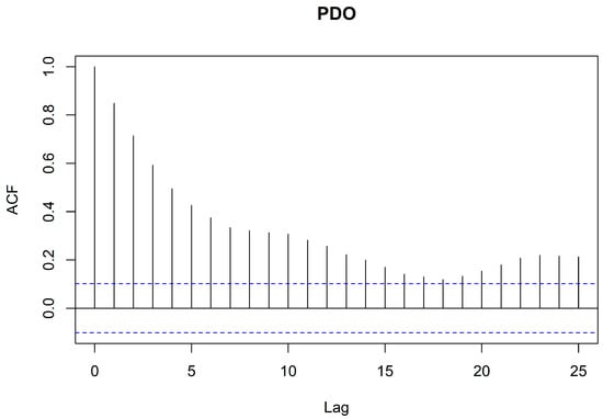
Figure 1


