


Abstract
Assessing hydropower potential in ungauged basins requires consistent derivation of key hydrological variables from heterogeneous geospatial and climatic data. Conventional GIS-based approaches often rely on fragmented, user-dependent workflows, limiting reproducibility and comparability. This study presents HYDROPOT, a web-based geospatial framework for the automated and reproducible extraction of hydrologically relevant basin descriptors for regional-scale hydropower screening. The platform integrates centralized datasets with server-side geoprocessing to delineate upstream catchments and compute quantitative basin descriptors, including drainage area (2–400 km2), Curve Number (CN), concentration time, and spatially aggregated monthly thermo-pluviometric variables derived from 95 stations over the 2004–2022 period. These descriptors provide essential inputs for rainfall–runoff modeling and preliminary discharge estimation, thereby supporting (although not directly performing) the assessment of water availability in ungauged basins. By eliminating manual preprocessing, HYDROPOT ensures consistent and reproducible analyses, reducing user-induced variability and improving comparability across applications, without implying increased predictive accuracy. The framework, applied to the Lazio Region (Central Italy) over the 2004–2022 period, enables rapid and transparent screening of river reaches, offering a scalable decision-support tool for preliminary, input-based screening in early-stage small hydropower planning.
1. Introduction
The transition toward low-carbon energy systems has intensified the need for reliable, scalable, and transparent tools to support the assessment and planning of renewable energy resources. Among these, hydropower remains one of the most mature and widely deployed technologies, contributing significantly to global electricity production [1,2]. In particular, small and mini-hydropower systems are increasingly recognized for their potential to provide decentralized and environmentally compatible energy solutions, especially in regions characterized by dense hydrographic networks [3,4].
A critical challenge in this context is the assessment of hydropower potential in ungauged or poorly monitored basins, where direct hydrological observations are limited or unavailable. In such settings, the estimation of water availability relies on indirect approaches based on geomorphological descriptors, land use information, and climatic variables [5,6]. These descriptors—such as drainage area, Curve Number, and concentration time—represent standardized inputs for rainfall–runoff modeling and preliminary discharge estimation, primarily in event-based or simplified hydrological analyses, which are essential for evaluating hydropower feasibility at early planning stages. Ensuring that these variables are derived consistently across multiple basins is therefore crucial for enabling reliable and comparable assessments at the regional scale.
Geographic Information Systems (GIS) have become a cornerstone of hydrological analysis and hydropower potential assessment, enabling the integration, processing, and visualization of spatial datasets at the catchment scale [7,8]. GIS-based methodologies typically rely on Digital Elevation Models (DEMs) to derive river networks, estimate hydraulic head, and delineate drainage basins, while hydrological models are used to approximate flow regimes and energy production potential [7,8]. These approaches have significantly improved the efficiency of preliminary site identification, reducing the time and cost associated with traditional field-based surveys [9,10]. Furthermore, integrated GIS frameworks have been successfully applied to combine morphometric analysis, hydrological modeling, and economic evaluation within unified workflows [11], as well as to incorporate environmental constraints and sustainability criteria [12]. Multi-criteria decision-making techniques, such as the Analytic Hierarchy Process (AHP), have further enhanced site selection by enabling the integration of multiple spatial indicators into suitability maps [13].
Despite these advances, several limitations persist from a hydrological perspective. Many existing approaches rely on workflows that are difficult to reproduce, as they involve manual preprocessing steps, fragmented software environments, and user-dependent parameter choices [14]. This lack of reproducibility affects the consistency of derived hydrological descriptors and limits the comparability of results across studies [15]. In addition, most GIS-based methodologies are implemented in desktop environments and require advanced technical expertise, restricting their accessibility to non-specialist users [15]. Although some web-based tools have recently been developed, they often provide only partial functionalities, lack integration with standardized geospatial datasets, or do not support fully automated workflows [16,17]. As a result, a gap remains between methodological developments and their practical application in large-scale, operational contexts [15,18].
Recent developments in web-based geospatial infrastructures and server-side geoprocessing offer a promising pathway to address these challenges. By centralizing data, models, and computational routines within a unified platform, such systems can ensure consistency in input datasets and automate the derivation of key hydrological variables, enabling fully reproducible analytical workflows [19]. This is particularly relevant for ungauged basins, where standardized procedures for extracting basin descriptors are essential for reducing uncertainty and ensuring comparability across regions. Moreover, the integration of geospatial databases with automated processing chains enhances both transparency and repeatability, allowing users to obtain hydrologically consistent results under uniform assumptions [20]. However, the application of these principles to hydropower assessment remains limited, particularly at the regional scale and in operational decision-support contexts [4,12].
To address these limitations, this study presents HYDROPOT, a web-based GIS application designed to provide a reproducible framework for the standardized extraction of hydrological basin descriptors to support the preliminary screening of hydropower potential in ungauged basins. The platform integrates centralized geospatial and meteorological datasets with automated catchment delineation and standardized parameter extraction [19,20]. It is important to note that HYDROPOT does not perform hydrological simulations or directly estimate discharge or energy production; rather, it provides consistently derived input variables that can support subsequent rainfall–runoff analyses and first-level assessments of water availability. By ensuring uniform data processing and minimizing user-dependent variability, the platform enables more transparent, scalable, and comparable analyses across large spatial domains [15,18].
The key novelty of HYDROPOT lies not only in its web-based implementation but also in its ability to provide a standardized and reproducible procedure for deriving hydrologically relevant basin descriptors across large spatial domains. By eliminating user-driven preprocessing steps typically performed in desktop GIS environments, the platform reduces user-induced variability and promotes more consistent derivation of variables, without fully constraining user choices or the inherent complexity of hydro-climatic systems. This represents a significant advancement over traditional GIS-based approaches, where differences in data handling and parameterization can lead to inconsistent hydrological interpretations.
By bridging the gap between hydrological theory and operational usability, HYDROPOT provides a practical decision-support tool for researchers, engineers, and public authorities involved in hydropower planning. More broadly, it contributes to the advancement of reproducible hydrological analysis, demonstrating how web-based infrastructures and automated workflows can support transparent, scalable, and comparable assessments of water resources and energy potential.
2. Materials and Methods
2.1. Study Area, Platform Scope and Data Sources
The HYDROPOT platform has been developed as a web-based GIS application to support the preliminary screening of hydropower potential within the Lazio Region (Central Italy), characterized by a total area of interest of 17,242 km2. The consistency of the outputs relies on the quality and standardization of these input datasets, which are preprocessed and harmonized within the platform following predefined procedures, enabling users to derive key hydrological and geomorphological indicators required for the identification of suitable sites for small and mini-hydropower development.
From a system architecture perspective, the proposed framework consists of three core components:
- Interactive Environment—A front-end interface enabling user interaction through a navigable map with drainage network and cross-sections overlays.
- Back-End and Database—This layer stores and manages preprocessed geospatial and hydrological data (e.g., corrected DEM, flow direction/accumulation, drainage network, land use, rainfall and temperature data), while also handling computational tasks and data exchange.
- Computational Routines—This module controls model execution by processing user inputs, calling geoprocessing models, and managing data exchange with the back-end and database.
From an operational perspective, the workflow proceeds as follows: (i) user selection of a river cross-section (the only required input), (ii) automatic watershed delineation, (iii) extraction of geomorphological and thermo-pluviometric descriptors, and (iv) output visualization and data export.
Starting from this selection, the system automatically delineates the corresponding upstream watershed and extracts a set of relevant parameters describing its physical and climatic characteristics. These include drainage area, land use–based runoff potential (expressed through Curve Number values), time of concentration, and spatially averaged thermo-pluviometric variables. Together, these indicators provide standardized inputs for simplified or event-based estimation of water availability and support a first-level, input-based evaluation of hydropower potential.
The analysis is specifically focused on drainage areas ranging between 2 km2 and 400 km2, corresponding to small river basins. These basins are typically ungauged or poorly monitored and therefore require indirect, data-driven approaches to assess hydrological behavior [21]. In this context, the integration of geomorphological descriptors and long-term meteorological information within a consistent spatial framework enables the identification of river reaches with higher potential for energy exploitation.
To ensure consistency and reproducibility, the platform relies on standardized input datasets, including the Copernicus EU-DEM (25 m resolution) for terrain analysis, which represents the reference spatial resolution adopted for all geomorphological processing within the framework, the official hydrographic network provided by ISPRA (https://www.isprambiente.gov.it/it, accessed on 7 April 2026) for drainage validation, the CORINE Land Cover 2018 dataset for land use characterization [22], and meteorological observations from the ARSIAL (https://www.arsial.it/, accessed on 12 April 2026) network for temperature and precipitation analysis. All datasets are preprocessed and harmonized within the system, allowing automated and repeatable analyses across the entire regional domain.
By combining centralized data management, automated watershed delineation, and integrated parameter extraction, HYDROPOT provides a scalable and reproducible framework for the rapid screening of hydropower potential. This approach allows users to move from raw geospatial data to actionable hydrological indicators through a single platform, significantly reducing the complexity and subjectivity typically associated with traditional GIS-based analyses.
2.2. Geomorphological Preprocessing and Terrain Analysis
The geomorphological analysis is based on a sequence of DEM preprocessing and terrain analysis procedures implemented within a GIS environment.
The pit-filling procedure was implemented using a depressionless DEM approach based on iterative elevation correction, ensuring hydrological connectivity without altering large-scale terrain features, in order to remove spurious topographic depressions that could affect flow routing [23]. Subsequently, a stream-burning procedure was applied using the ISPRA hydrographic network as a reference, by lowering DEM elevations along river paths with a fixed-depth enforcement to ensure alignment between modeled and observed drainage, in order to enforce consistency between the DEM-derived drainage network and the official hydrographic network provided by ISPRA. This step ensures that the extracted flow paths accurately reflect real river courses.
Flow direction and flow accumulation grids were then computed using the D8 algorithm [24], which assigns flow from each cell to the steepest downslope neighbor. These outputs were used to derive the drainage network and delineate contributing areas across the study region. Following validation of the DeM-derived river network against the official dataset, the network was discretized by generating points at regular 100 m intervals. These points represent potential river cross-sections and serve as interactive nodes within the web-based interface, allowing users to select specific locations for watershed extraction. Only nodes associated with contributing areas between 2 km2 and 400 km2 were retained for further analysis. Highly anthropized river reaches were excluded due to the need for higher-resolution, site-specific investigations.
Land use information from the CORINE (Copernicus Land Monitoring Service) Land Cover 2018 dataset was reclassified to assign Curve Number (CN) values according to the NRCS methodology, using lookup tables linking CORINE land cover classes to hydrological soil-cover complexes following established literature relationships [25]. It is noted that CN values are used here as generalized indicators of runoff potential rather than for direct event simulation. The reclassification was performed using lookup tables based on established relationships between land use classes and hydrological response, following the approach described in Grimaldi et al. [26].
2.3. Thermopluviometric Analysis, Watershed Delineation and Parameter Extraction
Meteorological data were obtained from 95 stations of the ARSIAL network, distributed across the Lazio Region. The dataset covers the period 2004–2022 and includes daily measurements of temperature and precipitation. Monthly aggregates were computed, including mean temperature (from daily averages), minimum temperature, maximum temperature, and total precipitation.
These variables were spatially interpolated using the Inverse Distance Weighting (IDW) method, with a power parameter equal to 2 and a variable search radius including the nearest stations (minimum 3, maximum 12) to produce continuous raster layers aligned with the spatial resolution and extent of the geomorphological datasets. The interpolation was performed on monthly aggregated data to reduce short-term variability and ensure consistency with the scale of the analysis.
The selection of a river cross-section within the platform triggers automated GIS routines for watershed delineation. Using the precomputed flow direction and accumulation grids, the upstream contributing area associated with the selected node is extracted.
For each delineated watershed, the platform computes the following parameters: total drainage area, average CN, concentration time (estimated using the Giandotti formula), monthly minimum, average, and maximum temperatures (spatially averaged over the basin), and total monthly precipitation (spatially averaged over the basin).
All outputs generated by the platform are made available for download to ensure transparency and reproducibility. These include both aggregated indicators and raster datasets associated with the delineated watershed: Digital Elevation Model (DEM), Flow Direction map, Flow Accumulation map, Land use map.
The entire workflow is executed through automated server-side geoprocessing routines, ensuring consistency in input datasets, processing steps, and results. This approach minimizes user-dependent variability and enables reproducible analyses across different users and applications. All spatial datasets were resampled to a common grid and aligned in terms of projection and resolution prior to analysis, ensuring consistency across geomorphological and climatic variables. These preprocessing steps follow standard GIS procedures and can be replicated independently of the platform.
2.4. Hydropower Potential Estimation Framework
The outputs provided by the HYDROPOT platform enable a preliminary, input-based hydrological assessment of water availability and hydropower potential for any selected watershed. In ungauged basins, discharge estimation relies on indirect approaches based on geomorphological and climatic descriptors. In this context, Curve Number and concentration time are not intended to represent long-term flow regimes, but rather to provide consistent descriptors supporting simplified rainfall–runoff-based estimations. The spatially averaged precipitation and temperature further support the characterization of hydrological regimes and their seasonal variability.
For contextual purposes, the theoretical hydropower potential (P) can be expressed as:
where P is the power (W), ρ is the water density (kg m−3), g is the gravitational acceleration (m s−2), Q is the discharge (m3 s−1), and H is the hydraulic head (m).
P = ρgQH
Within this framework, discharge (Q) is not directly computed by the platform but can be estimated externally using the derived basin descriptors, while the hydraulic head (H) can be approximated from elevation differences along the river reach using the DEM. Therefore, HYDROPOT does not perform hydropower calculations directly, but provides the necessary, consistently derived inputs to support reproducible first-level assessments.
Although the platform does not directly simulate hydrological processes or estimate hydropower production, it provides all the necessary, consistently derived inputs to support reproducible first-level hydrological assessments. This approach enables the rapid identification of river sections with higher potential for small and mini-hydropower development, while maintaining consistency in the derivation of key variables across different basins and users.
3. Results: The HYDROPOT Platform
The HYDROPOT platform is implemented as a web-based application that provides an interactive environment for exploring hydrological information and supporting the identification of potential sites for small-scale hydropower development. The system is accessible online (https://www.hydrolab.unitus.it/hydropot/#/dashboard, accessed on 7 May 2026) and is structured around a map-based interface that allows users to navigate across spatial scales and interact directly with the hydrographic network.
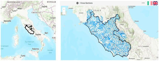
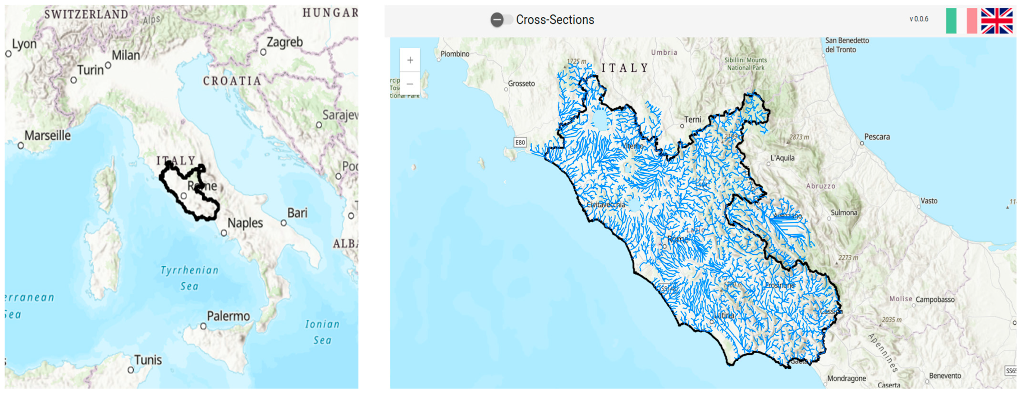
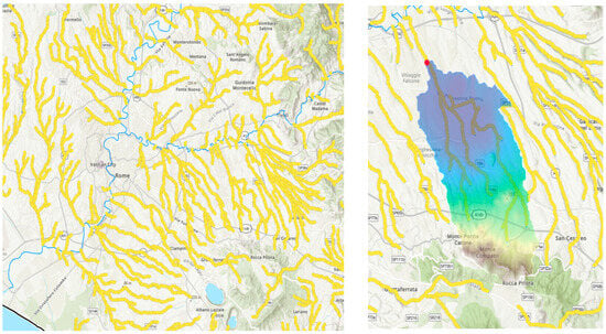
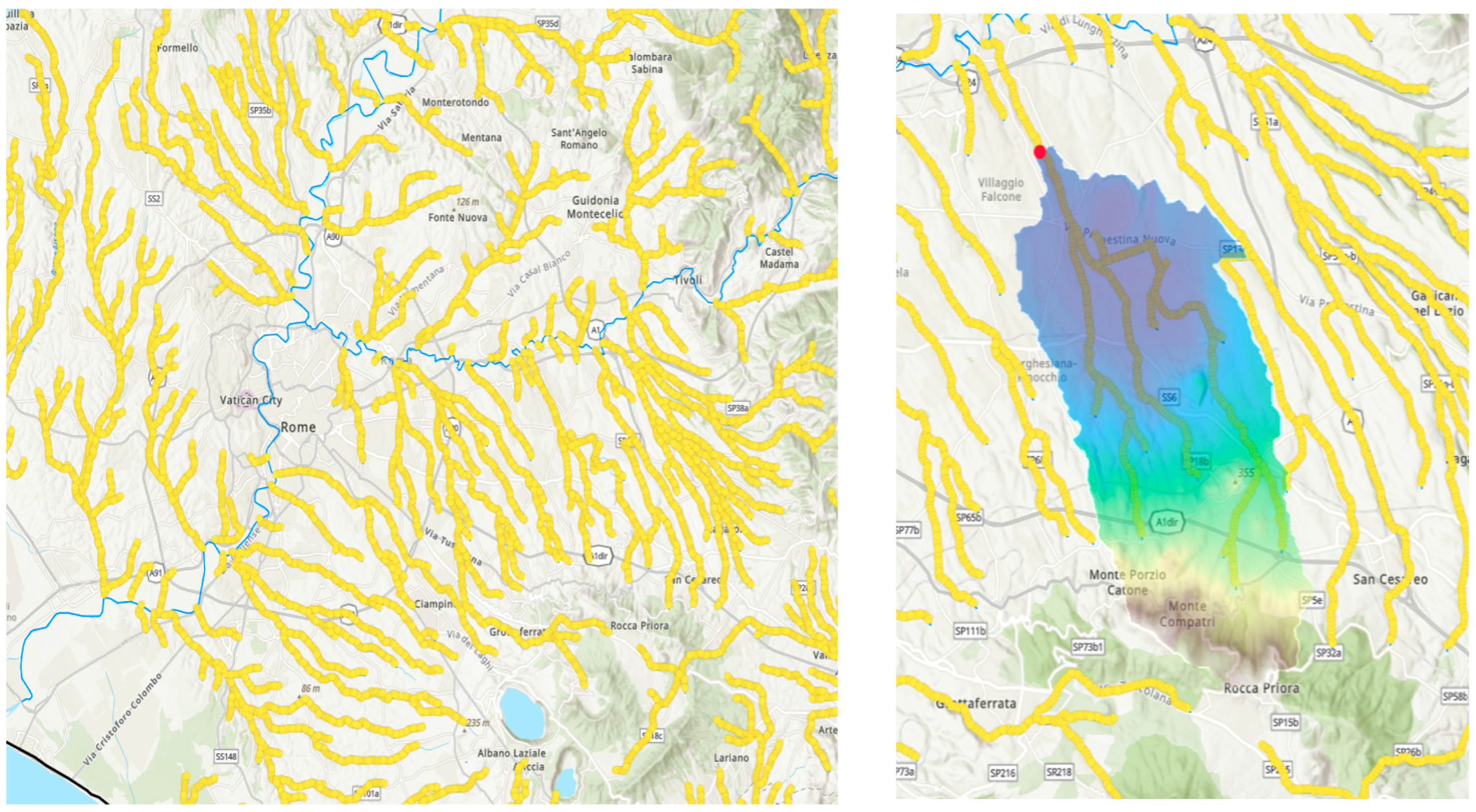
The core interaction consists of a map-based visualization of the regional hydrographic network, where preprocessed river cross-sections are displayed as selectable nodes. As shown in Figure 1, the platform allows users to navigate seamlessly between national and regional scales, providing spatial context for the analysis. The interactive map constitutes the main access point to the platform functionalities. The core interaction consists of selecting a river cross-section directly on the map (Figure 2). Each selectable point corresponds to a predefined outlet associated with a specific contributing area. Once selected, the platform automatically delineates the upstream watershed and retrieves the associated descriptors through server-side processing routines.
Figure 1.
Location of the study area (black polyline) at the national scale (left) and regional scale (Lazio Region, right).
Figure 2.
Interactive selection of river cross-sections (yellow points, left) and automatically delineated upstream watershed associated with the selected outlet (red point, right).
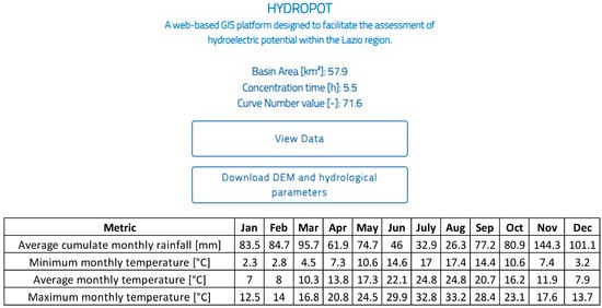
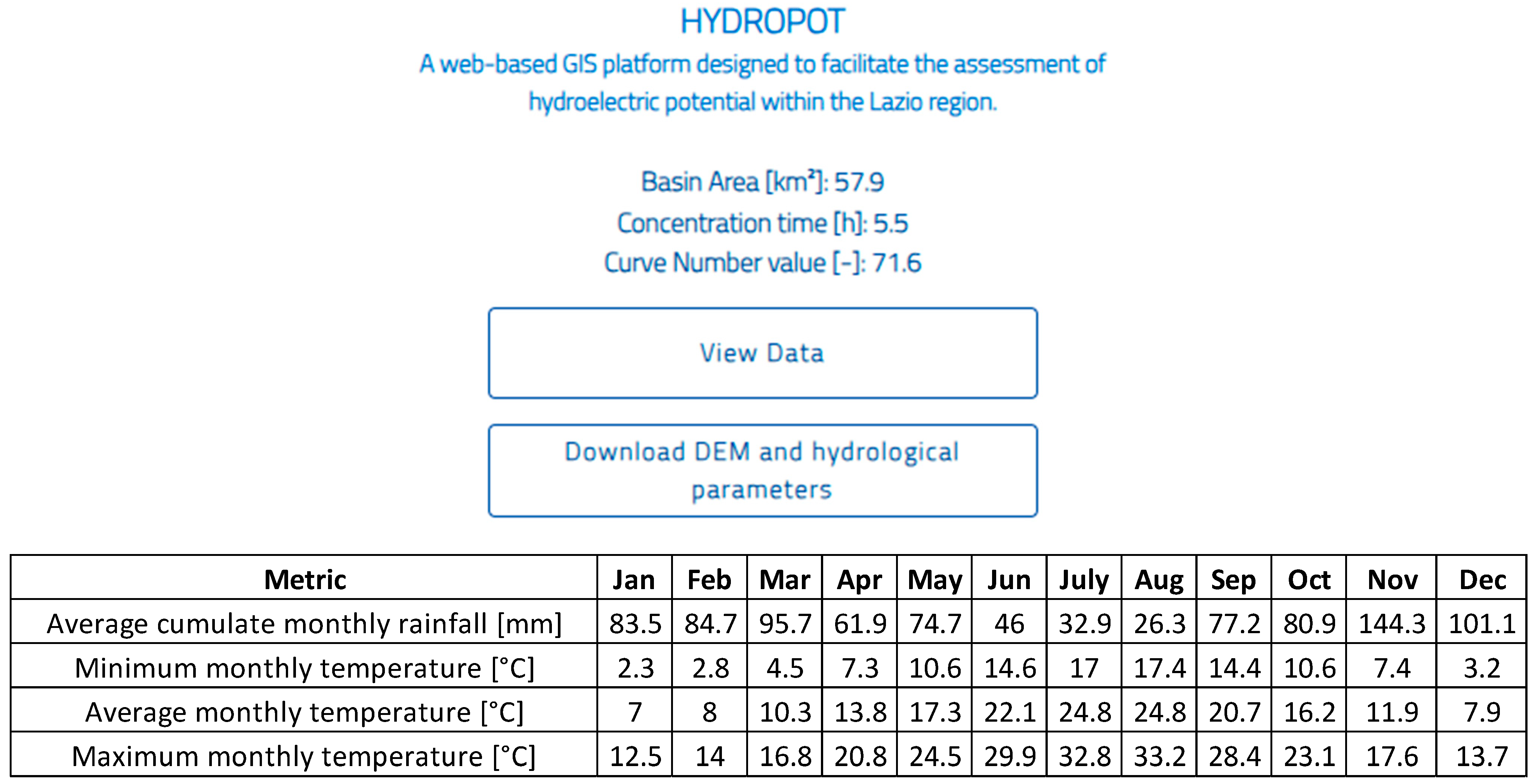
Following the selection, the platform returns a structured set of outputs describing the selected watershed (Figure 3). These outputs are presented in a clear and accessible format and include key indicators related to basin characteristics and climatic conditions. The visualization of results is coupled with the possibility of exporting both summary information and spatial datasets, enabling further offline analyses if required.
Figure 3.
Example of outputs provided by the platform, including basin area, concentration time, Curve Number (CN), and monthly precipitation and temperature averaged over the extracted watershed.
A distinctive aspect of the platform is the tight integration between data processing and visualization. All analytical operations are executed in the background, while the user interacts only with the results through the web interface. This separation allows the platform to maintain a simple and intuitive user experience while ensuring consistency in the underlying computations.
From an operational perspective, HYDROPOT supports rapid screening of multiple locations by allowing users to repeat the selection process across different river sections without additional processing steps. This capability is particularly useful in early-stage assessments, where a large number of potential sites must be evaluated in a consistent manner.
Overall, the platform translates complex geospatial analyses into a direct and accessible workflow, enabling users to obtain relevant hydrological information with minimal effort. By focusing on usability and interaction, HYDROPOT complements the methodological framework described in the previous sections and provides a practical tool for supporting decision-making processes in hydropower planning.
4. Discussion
The HYDROPOT platform addresses a key challenge in regional hydrological assessments, namely the need to derive consistent basin descriptors for ungauged catchments. In regional-scale analyses, variability in data preprocessing and parameter selection can lead to significant differences in hydrological indicators, affecting the comparability of results [15,18]. By formalizing the extraction of variables such as drainage area, Curve Number, and concentration time within a standardized workflow, the platform supports more coherent regional analyses and facilitates comparison of potential hydropower sites under uniform assumptions.
In comparison with existing GIS-based approaches for hydropower assessment, HYDROPOT introduces a shift from case-specific implementations toward a more systematic and transferable framework, with a specific focus on standardizing preprocessing steps rather than performing hydrological simulations. Previous studies have demonstrated the effectiveness of combining geomorphological analysis and hydrological modeling for site identification, typically relying on case-specific model setups and user-defined preprocessing workflows [9,10,11], as well as the integration of multi-criteria decision methods to incorporate environmental constraints [12,13]. However, these approaches are typically applied within project-specific contexts, making it difficult to replicate analyses across different regions or user groups. HYDROPOT contributes by enabling repeated application of the same analytical procedure across a large domain, thereby reducing user-dependent variability in data preprocessing and improving comparability across sites, supporting comparative screening rather than isolated evaluations.
The increasing availability of web-based geospatial infrastructures has opened new possibilities for hydrological applications [17,20]. Nevertheless, many existing tools are primarily oriented toward data visualization or provide limited analytical functionality [16]. In this context, HYDROPOT advances beyond visualization by directly linking user interaction with on-demand extraction of basin-scale hydrological information. This integration allows users to move from spatial selection to hydrologically meaningful outputs within a single workflow, which is particularly useful in exploratory and early-stage planning contexts.
From a hydrological perspective, the framework is particularly suited for preliminary assessments in ungauged basins, where indirect methods are required to infer flow characteristics. The standardized derivation of input variables reduces subjectivity in the application of rainfall–runoff approaches and supports more consistent estimation of discharge-related metrics across multiple sites. This aspect is especially relevant when the objective is not precise prediction, but the relative ranking or screening of potential locations.
Despite these advantages, some limitations should be acknowledged. The framework does not include direct hydrological simulation, discharge estimation, or validation against observed data, and therefore its outputs should be interpreted as indicative rather than predictive. In addition, the reliance on medium-resolution datasets may affect the representation of small-scale features, while the exclusion of highly anthropized reaches limits applicability in regulated systems. These aspects—primarily related to the absence of discharge validation, the use of medium-resolution input data, and the simplified representation of hydrological processes—should be considered when interpreting the results and defining subsequent, more detailed analyses.
Although HYDROPOT automates the full workflow within a web-based environment, all underlying procedures (DEM conditioning, watershed delineation, land use reclassification, and meteorological interpolation) are based on standard GIS techniques widely documented in the literature. The additional methodological details provided in this study are intended to facilitate independent replication of the approach in other regions using equivalent datasets.
Future developments may focus on coupling the current framework with rainfall–runoff models and expanding the range of input data to improve representation of local conditions. The integration of additional criteria, including environmental and regulatory constraints, would further support comprehensive decision-making processes.
5. Conclusions
This study presented HYDROPOT, a web-based framework designed to support the reproducible derivation of hydrological basin descriptors as inputs for the preliminary screening of hydropower potential at the regional scale. The platform integrates heterogeneous geospatial and meteorological datasets within a unified and automated workflow, enabling the consistent extraction of key variables such as drainage area, Curve Number, concentration time, and spatially aggregated thermo-pluviometric indicators.
From a hydrological perspective, the main contribution of HYDROPOT lies in providing a standardized approach for characterizing ungauged basins, where discharge estimation must rely on indirect methods. By ensuring that basin descriptors are derived under consistent assumptions, the platform supports subsequent rainfall–runoff analyses and preliminary assessments of water availability across large spatial domains. This reproducibility represents a relevant advancement over traditional GIS-based approaches, which are often affected by user-dependent preprocessing and heterogeneous data handling.
The system supports the identification of potentially suitable sites for small and mini-hydropower development. By combining automated geoprocessing with web-based accessibility, HYDROPOT enhances the transparency and accessibility of early-stage hydrological assessments.
However, the platform is intended for preliminary analysis and does not replace detailed hydrological modeling or site-specific investigations. Discharge is not directly simulated, and no calibration or validation against observed flow data is currently implemented. In addition, the spatial resolution of input datasets and the exclusion of highly anthropized river reaches may limit the applicability of results in complex environments. Future developments will focus on integrating rainfall–runoff models, improving spatial resolution, and incorporating additional modules for environmental constraints and energy production estimation.
Overall, HYDROPOT demonstrates how automated and reproducible workflows can support hydrological analyses in ungauged basins and provide a scalable basis for the preliminary evaluation of hydropower potential. The proposed framework contributes to improving the consistency, transparency, and operational applicability of hydropower screening at the regional scale.
Funding
This research was financed thanks to ‘Progetto ECS 0000024 Rome Technopole: CUP B83C22002820006, PNRR Missione 4 Componente 2 Investimento 1.5, finanziato dall’Unione europea–NextGenerationEU’. FP1-Decarbonization and digitalization in research on new green energy sources.
Data Availability Statement
The HYDROPOT platform is openly accessible at: https://www.hydrolab.unitus.it/hydropot/#/dashboard, accessed on 7 May 2026. Additional datasets used in this study are available from the corresponding author upon reasonable request.
Acknowledgments
The development and implementation of HYDROPOT have been strongly supported by the technical expertise of Innosystem s.r.l., whose contribution was essential and is sincerely acknowledged by the author.
Conflicts of Interest
The author declares no conflicts of interest.
References
- IEA (International Energy Agency). Hydropower; IEA: Paris, France, 2024; Available online: https://www.iea.org/energy-system/renewables/hydroelectricity (accessed on 15 April 2026).
- IHA (International Hydropower Association). World Hydropower Outlook 2025; International Hydropower Association: London, UK, 2025; Available online: https://www.hydropower.org/publications/2025-world-hydropower-outlook (accessed on 22 March 2026).
- Sofi, M.S.; Bhat, S.U. Small hydropower nexus: Debunking myths and assessing real impacts. SN Appl. Sci. 2025, 33, 16. [Google Scholar] [CrossRef] [Scilit]
- Duah, I.K.; Sekyere, C.K.K.; Kemausuor, F.; Amaning, K.A. Micro hydropower research and practice over the last decade for advancing decentralized energy access. Discov. Sustain. 2026, 7, 128. [Google Scholar] [CrossRef] [Scilit]
- Couto, T.B.A.; Olden, J.D. Global proliferation of small hydropower plants—Science and policy. Front. Ecol. Environ. 2018, 16, 91–100. [Google Scholar] [CrossRef] [Scilit]
- Azimov, U.; Avezova, N. Sustainable small-scale hydropower solutions in Central Asian countries for local and cross-border energy/water supply. Renew. Sustain. Energy Rev. 2022, 165, 112726. [Google Scholar] [CrossRef] [Scilit]
- Chen, H.-S.; Ho, H.-C.H. Applying GIS to identify potential location of small hydropower in catchment region. In Proceedings of the 39th IAHR World Congress, Granada, Spain, 19–24 June 2022. [Google Scholar]
- Grimaldi, S.; Petroselli, A.; Cappelli, F.; Piscopia, R.; Bianchini, S.; Centola, A.; Scarola, M.; De Gennaro, V.; Giove, M.R. An interactive platform for design hydrograph estimation in small and ungauged basins: Pilot implementation in the Lazio Region, Italy. Water 2025, 17, 3122. [Google Scholar] [CrossRef] [Scilit]
- Sammartano, V.; Liuzzo, L.; Freni, G. Identification of potential locations for run-of-river hydropower plants using a GIS-based procedure. Energies 2019, 12, 3446. [Google Scholar] [CrossRef] [Scilit]
- Tefera, W.M.; Kasiviswanathan, K.S. A global-scale hydropower potential assessment and feasibility evaluations. Water Resour. Econ. 2022, 38, 100198. [Google Scholar] [CrossRef] [Scilit]
- Palla, A.; Gnecco, I.; La Barbera, P.; Ivaldi, M.; Caviglia, D. An integrated GIS approach to assess the mini hydropower potential. Water Resour. Manag. 2016, 30, 2979–2996. [Google Scholar] [CrossRef] [Scilit]
- Paschetto, A.; Caselle, C.; Bonetto, S.M.R. A GIS-based methodology for hydropower potential assessment: Balancing energy production and ecosystem sustainability. Environ. Chall. 2025, 20, 101236. [Google Scholar] [CrossRef] [Scilit]
- Korkmaz, M. Geospatial evaluation of river basin small hydropower potential using AHP. Front. Environ. Sci. 2026, 14, 1749841. [Google Scholar] [CrossRef] [Scilit]
- Pal, D.; Saha, S.; Mukherjee, A.; Sarkar, P.; Banerjee, S.; Mukherjee, A. GIS-based modeling for water resource monitoring and management: A critical review. In Surface, Sub-Surface Hydrology and Management; Springer Geography; Springer: Cham, Switzerland, 2025. [Google Scholar]
- Knoben, W.J.M.; Clark, M.P.; Bales, J.; Bennett, A.; Gharari, S.; Marsh, C.B.; Nijssen, B.; Pietroniro, A.; Spiteri, R.J.; Tang, G.; et al. Community workflows to advance reproducibility in hydrologic modeling. Water Resour. Res. 2022, 58, e2021WR031753. [Google Scholar] [CrossRef] [Scilit]
- Li, W.; Hsu, C.-Y.; Wang, S.; Kedron, P. GeoAI reproducibility and replicability: A computational and spatial perspective. Ann. Am. Assoc. Geogr. 2024, 114, 2085–2103. [Google Scholar] [CrossRef] [Scilit]
- Pulla, S.T.; Yasarer, H.; Yarbrough, L.D. Transforming hydrology Python packages into web application programming interfaces: A comprehensive workflow using modern web technologies. Water 2024, 16, 2609. [Google Scholar] [CrossRef] [Scilit]
- Addor, N.; Melsen, L.A. Legacy, rather than adequacy, drives the selection of hydrological models. Water Resour. Res. 2019, 55, 378–390. [Google Scholar] [CrossRef] [Scilit]
- Maghami, I.; Van Beusekom, A.; Hay, L.; Li, Z.; Bennett, A.; Choi, Y.; Nijssen, B.; Wang, S.; Tarboton, D.; Goodall, J.L. Building cyberinfrastructure for the reuse and reproducibility of complex hydrologic modeling studies. Environ. Model. Softw. 2023, 165, 105689. [Google Scholar] [CrossRef] [Scilit]
- Choi, Y.-D.; Maghami, I.; Goodall, J.L.; Band, L.; Nassar, A.; Lin, L.; Saby, L.; Li, Z.; Wang, S.; Calloway, C.; et al. Toward reproducible and interoperable environmental modeling. Environ. Model. Softw. 2025, 183, 106239. [Google Scholar] [CrossRef] [Scilit]
- Grimaldi, S.; Volpi, E.; Langousis, A.; Papalexiou, S.M.; De Luca, D.L.; Piscopia, R.; Nerantzaki, S.; Papacharalampous, G.; Petroselli, A. Continuous hydrologic modelling for small and ungauged basins: A comparison of eight rainfall models for sub-daily runoff simulations. J. Hydrol. 2022, 610, 127866. [Google Scholar] [CrossRef] [Scilit]
- CORINE Project. CORINE Database for European Integrated Environmental Assessment; European Environment Agency: Copenhagen, Denmark, 2000. [Google Scholar]
- Jenson, S.K.; Domingue, J.O. Extracting topographic structure from digital elevation models. Photogramm. Eng. Remote Sens. 1988, 54, 1593–1600. [Google Scholar]
- O’Callaghan, J.F.; Mark, D.M. The extraction of drainage networks from digital elevation data. Comput. Vis. Graph. Image Process. 1984, 28, 323–344. [Google Scholar] [CrossRef] [Scilit]
- NRCS. Part 630 Hydrology, National Engineering Handbook; USDA: Washington, DC, USA, 2008.
- Grimaldi, S.; Petroselli, A.; Nardi, F. A parsimonious geomorphological unit hydrograph for rainfall–runoff modeling in small ungauged basins. Hydrol. Sci. J. 2012, 57, 73–83. [Google Scholar] [CrossRef] [Scilit]
Disclaimer/Publisher’s Note: The statements, opinions and data contained in all publications are solely those of the individual author(s) and contributor(s) and not of MDPI and/or the editor(s). MDPI and/or the editor(s) disclaim responsibility for any injury to people or property resulting from any ideas, methods, instructions or products referred to in the content. |
© 2026 by the author. Licensee MDPI, Basel, Switzerland. This article is an open access article distributed under the terms and conditions of the Creative Commons Attribution (CC BY) license.