Skip to Content

Hydrology

Hydrology is an international, peer-reviewed, open access journal on hydrology published monthly online by MDPI.
The American Institute of Hydrology (AIH) and Japanese Society of Physical Hydrology (JSPH) are affiliated with Hydrology and their members receive discounts on the article processing charges.
Quartile Ranking JCR - Q2 (Water Resources)

Get Alerted

Add your email address to receive forthcoming issues of this journal.

All Articles (1,763)

Hydrological Forcing of Anthropogenic Pulses of Trace Metal Mass Loading in the Santiago River, Mexico

  • Aida Alejandra Guerrero de León,
  • Valerie Natalia Salazar-Zepeda and
  • Jesús Barrera-Rojas
  • + 3 authors

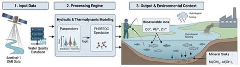
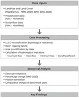
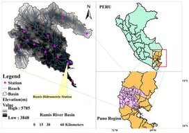
The Santiago River is a highly anthropogenically impaired lotic system globally, yet the mechanisms governing its contaminant transport remain poorly understood under static monitoring paradigms. This study evaluates how hydrological forcing dictates the mobilization and bioavailability of trace metals by integrating a 15-year public hydrochemical database from 10 monitoring nodes with SAR-derived discharge estimates and thermodynamic metal modeling (PHREEQC). To validate the structural integrity of the mass load estimates against hydrometric uncertainties, a deterministic boundary-sensitivity analysis was conducted. Results empirically refute the classical dilution paradigm, introducing the “Anthropogenic Pulse” to describe the non-linear acceleration of pollutant export during high-flow events (discharge Q surging from 36.62 to 286.13 m3/s). While climate-driven parameters follow seasonal cycles, industrial stressors (COD, Pb, Cd) remain in a chronic steady state, decoupling from volumetric dilution. Based on coupled × CQ × C (discharge × concentration) estimates, this dynamic induces a synchronized flushing of toxic burdens, exporting monthly peak loads exceeding 51,000 kg of Zinc, 6500 kg of Lead, and 3100 kg of Cadmium. Thermodynamic simulations reveal that this hydrological flushing functions as a chemical activator; the seasonal dilution of natural Alkalinity and Hardness suppresses the river’s theoretical buffered pH (from 8.5 to 7.0), maintaining metals in their uncomplexed free-ion states (Me2+). Modeling indicates that nearly 90% of the exported Cadmium remains in this highly labile, toxic form due to a dual coupling with both river Discharge (rs = 0.87) and pH (rs = 0.79). The identification of stochastic arsenic peaks 100 times above regulatory limits at Paso de Guadalupe (RS-08) underscores the failure of concentration-based monitoring. Our findings suggest that restoration strategies should shift toward mass-loading-based regulatory frameworks and targeted sediment management at critical nodes to mitigate the chronic export of bioavailable industrial waste.

18 June 2026

Workflow for quantifying the impact of hydrological forcing and flushing on hydrochemical dynamics and metal bioavailability in the Santiago River, Mexico. The diagram illustrates a three-stage sequential framework: (1) Input Data phase delivering independent physical and hydrochemical datasets, (2) Processing Engine phase representing data integration and thermodynamic modeling, and (3) Output & Environmental Context phase showing the final geochemical mapping mapped onto a conceptual river reach with directional arrows indicating flow and mass transport dynamics.

Land use and land cover change (LULCC) is increasingly recognized as a dominant driver of hydrological alteration in tropical watersheds, often exceeding the influence of climatic variability. This study evaluates the spatiotemporal dynamics of LULCC and their implications for hydrological sustainability in the Uberabinha River Basin, southeastern Brazil, between 1990 and 2020. Utilizing MapBiomas data and statistical analysis, the results reveal a marked expansion of mechanized agriculture, particularly soybean cultivation, which grew from 3426 ha to 54,162 ha, and urban areas, which expanded by approximately 89.4%. Conversely, natural vegetation and pasturelands decreased continuously, with pastures showing the sharpest absolute reduction, from 72,248 ha to 34,535 ha. Despite a 10.76% increase in annual precipitation between 1990 and 2020, the hydrological response exhibited a severe decline in streamflow, characterized by a 76.35% drop in minimum flow. Furthermore, the runoff index decreased from 0.0574 in 1990 to 0.0211 in 2020, indicating a critical loss in the basin’s capacity to convert rainfall into streamflow. These findings demonstrate a clear decoupling between precipitation and streamflow driven by LULCC, posing a severe threat to regional water security and highlighting the urgent need for integrated land–water management.

17 June 2026

Methodological framework.

Climate change is expected to significantly alter hydrological regimes in high-altitude tropical basins, where water availability strongly depends on precipitation variability and groundwater processes. The Ramis River basin, a major tributary of Lake Titicaca in the Peruvian Altiplano, is particularly vulnerable to hydroclimatic variability due to its dependence on seasonal water resources. This study evaluates the impacts of climate change on runoff, groundwater recharge, percolation, and renewable water resources using the SWAT hydrological model calibrated and validated for the period 1981–2024. Future projections were developed using the MPI-ESM-MR and ACCESS1-0 global climate models under RCP 4.5 and RCP 8.5 scenarios for the period 2025–2100, applying bias correction through CMhyd. The results indicate a strong sensitivity of basin hydrology to climate forcing. Under the MPI-ESM-MR model, runoff decreases by up to 68% under RCP 4.5, while extreme increases exceeding 130% are projected under RCP 8.5. In contrast, ACCESS1-0 shows moderate reductions in most scenarios. Renewable water resources exhibit a general declining trend (−23% to −41%), suggesting increasing water scarcity conditions. Additionally, the Standardized Precipitation Index (SPI) reveals a higher frequency and persistence of drought events toward the end of the century, particularly under high-emission scenarios. Overall, the findings indicate that the Ramis River basin may face a dual hydroclimatic risk characterized by reduced water availability and increased hydrological extremes. These results highlight the need to integrate climate projections into water resource management and to implement adaptive strategies to reduce future water vulnerability in high-Andean basins.

17 June 2026

Location and spatial configuration of the Ramis River basin.

With global warming continuously worsening drought hazards, the Fuhe River Basin urgently requires insight into drought evolution laws to support resilient water resources management. However, traditional univariate indices such as the Standardized Precipitation Index (SPI) and Standardized Soil Moisture Index (SSI) are limited by their inability to capture the coupled meteorological-agricultural drought process and the time-lag effects between precipitation and soil moisture response. Therefore, a multivariate drought index—which integrates both precipitation and soil moisture information—is needed as a core tool for drought early warning and precise regulation. In this study, the calibrated SWAT model was used to simulate monthly soil moisture content in the Fuhe River Basin over the past 60 years. On a 3-month time scale, a Multivariate Standardized Drought Index (MSDI) was established by coupling the Standardized Precipitation Index (SPI) and Standardized Soil Moisture Index (SSI) using the Copula function. The main findings are as follows: (1) The Nash–Sutcliffe efficiency coefficient (NS) of the SWAT (Soil and Water Assessment Tool) model during the validation period reached above 0.70, indicating favorable performance in monthly runoff simulation. (2) The MSDI revealed frequent drought events in two periods, namely 1960–1979 and 2000–2019, demonstrating the periodic fluctuation pattern of droughts in the basin. (3) Wavelet analysis showed that compared with the previous two periods, the frequency of droughts in the basin increased significantly after 2000, with weakened periodic characteristics, intensified extreme drought events, and a further rise in drought risks. This study deepens the understanding of drought dynamics in the Fuhe River Basin and provides a scientific basis for regional sustainable water resource management and the formulation of climate adaptation strategies.

16 June 2026

Distribution of the Fuhe River Basin and its hydro-meteorological stations.

News & Conferences

Volumes

Latest Issues

Open for Submission

Editor's Choice

XFacebookLinkedIn
Hydrology - ISSN 2306-5338