Skip to Content
You are currently on the new version of our website. Access the old version .

ISPRS International Journal of Geo-Information, Volume 9, Issue 1

2020 January - 60 articles

Cover Story: 
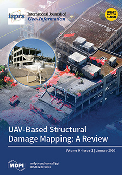
The cover image shows a 3D point cloud of a damaged building in Lyon, France, calculated from stereo imagery obtained with a consumer UAV/drone (DJI Phantom 3, inset) in the context of a European-funded research project (INACHUS, www.inachus.eu). The project focused on the development of methods to support first responders in search and rescue activities following accidents or disasters. The image illustrates the use of UAV in detailed scene reconstruction, and how the derived information together with advanced machine learning are used for structural damage detection, superimposed in red on the model. The article provides a detailed review of how UAV have been used in structural damage assessment.View this paper.
  • Issues are regarded as officially published after their release is announced to the table of contents alert mailing list .
  • You may sign up for email alerts to receive table of contents of newly released issues.
  • PDF is the official format for papers published in both, html and pdf forms. To view the papers in pdf format, click on the "PDF Full-text" link, and use the free Adobe Reader to open them.

Articles (60)

  • Article
  • Open Access
33 Citations
12,100 Views
12 Pages

Linguistic landscape research focuses on relationships between written languages in public spaces and the sociodemographic structure of a city. While a great deal of work has been done on the evaluation of linguistic landscapes in different cities, m...

  • Feature Paper
  • Review
  • Open Access
55 Citations
14,972 Views
28 Pages

Spaces in Spatial Science and Urban Applications—State of the Art Review

  • Sisi Zlatanova,
  • Jinjin Yan,
  • Yijing Wang,
  • Abdoulaye Diakité,
  • Umit Isikdag,
  • George Sithole and
  • Jack Barton

In spatial science and urban applications, “space" is presented by multiple disciplines as a notion referencing our living environment. Space is used as a general term to help understand particular characteristics of the environment. However, the def...

  • Article
  • Open Access
34 Citations
6,299 Views
15 Pages

Negative binomial (NB) regression model has been used to analyze crime in previous studies. The disadvantage of the NB model is that it cannot deal with spatial effects. Therefore, spatial regression models, such as the geographically weighted Poisso...

  • Article
  • Open Access
9 Citations
4,267 Views
21 Pages

Detecting Intra-Urban Housing Market Spillover through a Spatial Markov Chain Model

  • Daijun Zhang,
  • Xiaoqi Zhang,
  • Yanqiao Zheng,
  • Xinyue Ye,
  • Shengwen Li and
  • Qiwen Dai

This study analyzed the spillovers among intra-urban housing submarkets in Beijing, China. Intra-urban spillover imposes a methodological challenge for housing studies from the spatial and temporal perspectives. Unlike the inter-urban spillover, the...

  • Article
  • Open Access
9 Citations
4,750 Views
18 Pages

Average speed is crucial for calculating link travel time to find the fastest path in a road network. However, readily available data sources like OpenStreetMap (OSM) often lack information about the average speed of a road. However, OSM contains oth...

  • Case Report
  • Open Access
28 Citations
9,993 Views
18 Pages

Indonesia is an archipelago country in which the tourism sector plays a role as an economic locomotive. In 2016, Indonesia joined the World Halal Tourism Award (WHTA) and won 12 awards, three of which were won by West Sumatra. Bukittinggi is the prin...

  • Article
  • Open Access
14 Citations
4,808 Views
22 Pages

Comprehensive user evaluations of outdoor augmented reality (AR) applications in the architecture, engineering, construction and facilities management (AEC/FM) industry are rarely reported in the literature. This paper presents an AR prototype system...

  • Article
  • Open Access
19 Citations
7,962 Views
22 Pages

The U.S. electric-power infrastructure urgently needs renovation. Recent major power outages in California, New York, Texas, and Florida have highlighted U.S. electric-power unreliability. The media have discussed the U.S. aging power infrastructure...

  • Article
  • Open Access
28 Citations
6,368 Views
18 Pages

Spatio-Temporal Prediction of the Epidemic Spread of Dangerous Pathogens Using Machine Learning Methods

  • Wolfgang B. Hamer,
  • Tim Birr,
  • Joseph-Alexander Verreet,
  • Rainer Duttmann and
  • Holger Klink

Real-time identification of the occurrence of dangerous pathogens is of crucial importance for the rapid execution of countermeasures. For this purpose, spatial and temporal predictions of the spread of such pathogens are indispensable. The R package...

  • Article
  • Open Access
12 Citations
4,242 Views
19 Pages

While a road pattern influences wayfinding and navigation, its influence on the gaze behaviours of navigating pedestrians is not well documented. In this study, we compared gaze behaviour differences between regular and irregular road patterns using...

  • Article
  • Open Access
23 Citations
6,885 Views
23 Pages

An Efficient Staged Evacuation Planning Algorithm Applied to Multi-Exit Buildings

  • Litao Han,
  • Huan Guo,
  • Haisi Zhang,
  • Qiaoli Kong,
  • Aiguo Zhang and
  • Cheng Gong

When the occupant density of buildings is large enough, evacuees are prone to congestion during emergency evacuation, which leads to the extension of the overall escape time. Especially for multi-exit buildings, it’s a challenging problem to afford a...

  • Article
  • Open Access
4 Citations
4,236 Views
35 Pages

Hydropower dam displacement is influenced by various factors (dam ageing, reservoir water level, air, water, and concrete temperature), which cause complex nonlinear behaviour that is difficult to predict. Object deformation monitoring is a task of g...

  • Review
  • Open Access
37 Citations
8,747 Views
31 Pages

Interactive Planning Support Systems (PSS) implemented on a maptable are deemed suitable to support participatory planning processes. They are supposed to facilitate exchange of knowledge between stakeholders, consensus building among them, and group...

  • Article
  • Open Access
11 Citations
3,914 Views
17 Pages

Uncertainty Analysis of Remote Sensing Pretreatment for Biomass Estimation on Landsat OLI and Landsat ETM+

  • Qi Zhang,
  • Lihua Xu,
  • Maozhen Zhang,
  • Zhi Wang,
  • Zhangfeng Gu,
  • Yaqi Wu,
  • Yijun Shi and
  • Zhangwei Lu

The accurate quantification of biomass helps to understand forest productivity and carbon cycling dynamics. Research on uncertainty during pretreatment is still lacking despite it being one of the major sources of uncertainty and an essential step in...

  • Article
  • Open Access
8 Citations
3,343 Views
21 Pages

Light detection and ranging (Lidar) spatial coordinates, especially height data, and the intensity data of point clouds are often used for strip adjustment in airborne Lidar. However, inconsistency in the intensity data and then intensity gradient da...

  • Article
  • Open Access
7 Citations
3,576 Views
20 Pages

Integrated Visualization Approach for Real-Time and Dynamic Assessment of Storm Surge Disasters for China’s Seas

  • Lin Zhou,
  • Wei Hu,
  • Zhen Jia,
  • Xinfang Li,
  • Yaru Li,
  • Tianyun Su and
  • Qingsheng Guo

For improved prevention and reduction of marine disasters, China’s marine authorities and emergency response agencies require a solution that provides risk assessment, early warning, and decision-making support. This paper proposes a comprehens...

  • Article
  • Open Access
7 Citations
4,256 Views
16 Pages

A GRID-Based Spatial Interpolation Method as a Tool Supporting Real Estate Market Analyses

  • Agnieszka Szczepańska,
  • Dariusz Gościewski and
  • Małgorzata Gerus-Gościewska

The spatial distribution of prices is closely linked with the urban real estate market. Property prices are one of the key indicators of economic activity because they influence economic decisions. Decision-makers and consumers often need information...

  • Article
  • Open Access
28 Citations
6,929 Views
18 Pages

In this research, the concept of livability has been quantitatively and comprehensively reviewed and interpreted to contribute to spatial multi-objective land use optimization modelling. In addition, a multi-objective land use optimization model was...

  • Article
  • Open Access
26 Citations
6,299 Views
21 Pages

Assessing Emergency Shelter Demand Using POI Data and Evacuation Simulation

  • Wei Chen,
  • Yao Fang,
  • Qing Zhai,
  • Wei Wang and
  • Yijie Zhang

Mapping the fine-scale spatial distribution of emergency shelter demand is crucial for shelter planning during disasters. To provide shelter for people within a reasonable evacuation distance under day and night disaster scenarios, we formed an appro...

  • Article
  • Open Access
9 Citations
4,615 Views
20 Pages

Where Urban Youth Work and Live: A Data-Driven Approach to Identify Urban Functional Areas at a Fine Scale

  • Yiming Yan,
  • Yuanyuan Wang,
  • Zhenhong Du,
  • Feng Zhang,
  • Renyi Liu and
  • Xinyue Ye

As a major labor force of cities, young people provide a huge driving force for urban innovation and development, and contribute to urban industrial upgrading and restructuring. In addition, with the acceleration of urbanization in China, the young f...

  • Article
  • Open Access
2 Citations
3,297 Views
14 Pages

A quadrilateral table cartogram is a rectangle-shaped figure that visualizes table-form data; quadrilateral cells in a table cartogram are transformed to express the magnitude of positive weights by their areas, while maintaining the adjacency of cel...

  • Article
  • Open Access
66 Citations
9,974 Views
17 Pages

Some studies have confirmed the association between urban public services and population density; however, other studies using census data, for example, have arrived at the opposite conclusion. Mobile signaling data provide new technological tools to...

  • Article
  • Open Access
4 Citations
4,670 Views
21 Pages

Generalization of geographic information enables cognition and understanding not only of objects and phenomena located in space but also the relations and processes between them. The automation of this process requires formalization of cartographic k...

  • Article
  • Open Access
19 Citations
7,803 Views
18 Pages

A Data-Driven Framework for Walkability Measurement with Open Data: A Case Study of Triple Cities, New York

  • Chengbin Deng,
  • Xiaoyu Dong,
  • Huihai Wang,
  • Weiying Lin,
  • Hao Wen,
  • John Frazier,
  • Hung Chak Ho and
  • Louisa Holmes

Walking is the most common, environment-friendly, and inexpensive type of physical activity. To perform in-depth walkability analysis, one option is to objectively evaluate different aspects of built environment related to walkability. In this study,...

  • Article
  • Open Access
18 Citations
5,103 Views
21 Pages

Procedures for Condition Mapping Using 360° Images

  • Luigi Barazzetti,
  • Mattia Previtali and
  • Marco Scaioni

The identification of deterioration mechanisms and their monitoring over time is an essential phase for conservation. This work aimed at developing a novel approach for deterioration mapping and monitoring based on 360° images, which allows for s...

  • Article
  • Open Access
76 Citations
9,177 Views
16 Pages

Under the background of urban expansion, ecological protection cannot be delayed. The construction of ecological networks is of considerable significance to ecosystem services. However, in the process of constructing a corridor network, there is no u...

  • Article
  • Open Access
16 Citations
4,848 Views
17 Pages

Map Matching for Urban High-Sampling-Frequency GPS Trajectories

  • Minshi Liu,
  • Ling Zhang,
  • Junlian Ge,
  • Yi Long and
  • Weitao Che

As a fundamental component of trajectory processing and analysis, trajectory map-matching can be used for urban traffic management and tourism route planning, among other applications. While there are many trajectory map-matching methods, urban high-...

  • Article
  • Open Access
26 Citations
4,776 Views
13 Pages

The nighttime light (NTL) imagery acquired from the Visible Infrared Imaging Radiometer Suite (VIIRS) Day/Night Band (DNB) enables feasibility of investigating socioeconomic activities at monthly scale, compared with annual study using nighttime ligh...

  • Article
  • Open Access
15 Citations
5,289 Views
18 Pages

Geographic information-based planning support tools implemented in a maptable have the potential to mediate collaborative spatial planning processes. However, available tools for a maptable either lack advanced analytical functions or have usability...

  • Article
  • Open Access
5 Citations
3,400 Views
22 Pages

Soil health plays a major role in the ability of any nation to meet the Sustainable Development Goals. Understanding the spatial variability of soil health indicators (SHIs) may help decision makers develop effective policy strategies and make approp...

  • Article
  • Open Access
7 Citations
3,641 Views
13 Pages

Spatial and Temporal Evolution of the Infiltration Characteristics of a Loess Landslide

  • Dongdong Yang,
  • Haijun Qiu,
  • Yanqian Pei,
  • Sheng Hu,
  • Shuyue Ma,
  • Zijing Liu,
  • Yan Zhang and
  • Mingming Cao

Infiltration plays an important role in influencing slope stability. However, the influences of slope failure on infiltration and the evolution of infiltration over time and space remain unclear. We studied and compared the infiltration rates in undi...

  • Article
  • Open Access
4 Citations
3,063 Views
11 Pages

Circular arcs are a graphical element present in the cadastral systems of many countries. Unfortunately, this type of record of the geometry of parcel borders is a problem described by the directives of Infrastructure for Spatial Information in Europ...

  • Article
  • Open Access
39 Citations
9,912 Views
18 Pages

Land Suitability for Sustainable Aquaculture of Rainbow Trout (Oncorhynchus mykiss) in Molinopampa (Peru) Based on RS, GIS, and AHP

  • Christian Ricardo Calle Yunis,
  • Rolando Salas López,
  • Segundo Manuel Oliva Cruz,
  • Elgar Barboza Castillo,
  • Jhonsy Omar Silva López,
  • Daniel Iliquín Trigoso and
  • Nilton B. Rojas Briceño

Peruvian aquaculture, specifically trout production, has had significant growth over the past ten years. However, the establishment and expansion of small-scale aquaculture have been carried out without considering the suitability of the land. In Per...

  • Article
  • Open Access
19 Citations
19,623 Views
18 Pages

The city-building game Cities: Skylines simulates urban-related processes in a visually appealing 3D environment and thus offers interesting possibilities for visualizations of real-world places. Such visualizations could be used for presentation, pa...

  • Article
  • Open Access
8 Citations
3,876 Views
21 Pages

This paper presents an automatic building extraction method which utilizes a photogrammetric digital surface model (DSM) and digital orthophoto map (DOM) with the help of historical digital line graphic (DLG) data. To reduce the need for manual label...

  • Article
  • Open Access
3 Citations
3,917 Views
23 Pages

Uncertainty Visualization of Transport Variance in a Time-Varying Ensemble Vector Field

  • Ke Ren,
  • Dezhan Qu,
  • Shaobin Xu,
  • Xufeng Jiao,
  • Liang Tai and
  • Huijie Zhang

Uncertainty analysis of a time-varying ensemble vector field is a challenging topic in geoscience. Due to the complex data structure, the uncertainty of a time-varying ensemble vector field is hard to quantify and analyze. Measuring the differences b...

  • Article
  • Open Access
13 Citations
3,608 Views
17 Pages

Efficient Estimation of Biomass from Residual Agroforestry

  • Marco Bascietto,
  • Giulio Sperandio and
  • Sofia Bajocco

Cost-effective sampling methods for the estimation of variables of interest that are time-consuming are a major concern. Ranked set sampling (RSS) is a sampling method that assumes that a set of sampling units drawn from the population can be ranked...

  • Article
  • Open Access
37 Citations
5,097 Views
26 Pages

Hemeroby is an integrated indicator used to measure the impact and degree of all human interventions on ecological components or ecosystems. The constant exploitation of resources is a strong interference of human beings to the natural environment. W...

  • Article
  • Open Access
2 Citations
2,841 Views
18 Pages

Patterns of School Preference about the Local Heritage in Medium-Size Cities of Castilla-La Mancha (Spain). The Case of Ciudad Real

  • María Ángeles Rodríguez Domenech,
  • Ana Isabel Callejas Albiñana and
  • Miguel González-Mohino Sánchez

Context: The comprehension of patterns regarding the knowledge that grade schoolers of a certain city have, just like the facts which favor or alter this, been of great interest, as they allow one to conduct subsequent comparative analyses with group...

  • Article
  • Open Access
6 Citations
3,938 Views
17 Pages

Field Geological Investigations and Stability Analysis of Duanjiagou Landslide

  • Xingang Wang,
  • Tangdai Xia,
  • Longju Zhang,
  • Min Gao and
  • Kang Cheng

This paper analyses the stability of the Duanjiagou landslide on the Bazhong to Guangan Expressway K134–K135 segment in China. The Duanjiagou landslide took place on 4 November 2015. In order to discover the cause of the landslide, we carried o...

  • Article
  • Open Access
30 Citations
9,512 Views
16 Pages

Several areas of Earth that are rich in oil and natural gas also have huge deposits of salt below the surface. Because of this connection, knowing precise locations of large salt deposits is extremely important to companies involved in oil and gas ex...

  • Article
  • Open Access
5 Citations
4,220 Views
13 Pages

Vertex concavity-convexity detection for spatial objects is a basic algorithm of computer graphics, as well as the foundation for the implementation of other graphics algorithms. In recent years, the importance of the vertex concavity-convexity detec...

  • Article
  • Open Access
15 Citations
5,533 Views
15 Pages

The Database of Topographic Objects (DTO) is the official database of Poland for collecting and providing spatial data with the detail level of a topographic map. Polish national DTOs manage information about the spatial location and attribute values...

  • Article
  • Open Access
103 Citations
9,403 Views
22 Pages

Deep Learning-Based Named Entity Recognition and Knowledge Graph Construction for Geological Hazards

  • Runyu Fan,
  • Lizhe Wang,
  • Jining Yan,
  • Weijing Song,
  • Yingqian Zhu and
  • Xiaodao Chen

Constructing a knowledge graph of geological hazards literature can facilitate the reuse of geological hazards literature and provide a reference for geological hazard governance. Named entity recognition (NER), as a core technology for constructing...

  • Review
  • Open Access
172 Citations
17,521 Views
23 Pages

UAV-Based Structural Damage Mapping: A Review

  • Norman Kerle,
  • Francesco Nex,
  • Markus Gerke,
  • Diogo Duarte and
  • Anand Vetrivel

Structural disaster damage detection and characterization is one of the oldest remote sensing challenges, and the utility of virtually every type of active and passive sensor deployed on various air- and spaceborne platforms has been assessed. The pr...

  • Article
  • Open Access
7 Citations
4,328 Views
15 Pages

In the process of economic urbanization, because of competition among cities, agglomerations and polarization of regional economies are produced. This paper studies the urban polarization with Chinese characteristics and the regional economic urbaniz...

  • Article
  • Open Access
1 Citations
3,498 Views
26 Pages

A Novel Infringement Detection Method for GIS Vector Data

  • Zhi Tang,
  • Yun Zhang,
  • Jing Huang,
  • Hao He and
  • Yue Ding

There is undoubtedly a groundswell of support for the concept of geographic data sharing with the rapid development and wide-ranging application of geographic information science. However, copyright protection and infringement detection in the proces...

  • Article
  • Open Access
18 Citations
4,237 Views
34 Pages

Geospatial information is gaining immense interest and importance as we enter the era of highly developed transportation and communication. Despite the proliferation of cellular network and WiFi, on some occasions, users still face barriers to access...

of 2

Get Alerted

Add your email address to receive forthcoming issues of this journal.

XFacebookLinkedIn
ISPRS Int. J. Geo-Inf. - ISSN 2220-9964