



Journal Description
Land
Land
is an international, cross-disciplinary, peer-reviewed, open access journal on land system science, landscape, soil and water, urban study, land–climate interactions, water–energy–land–food (WELF) nexus, biodiversity research and health nexus, land modelling and data processing, ecosystem services, multifunctionality and sustainability, and is published monthly online by MDPI. The International Association for Landscape Ecology (IALE), International Federation of Landscape Architects (IFLA), European Land-use Institute (ELI), Landscape Institute (LI) and Urban Land Institute (ULI) are affiliated with Land, and their members receive discounts on the article processing charges.
- Open Access— free for readers, with article processing charges (APC) paid by authors or their institutions.
- High Visibility: indexed within Scopus, SSCI (Web of Science), GEOBASE, PubAg, AGRIS, GeoRef, RePEc, and other databases.
- Journal Rank: JCR - Q2 (Environmental Studies) / CiteScore - Q1 (Nature and Landscape Conservation)
- Rapid Publication: manuscripts are peer-reviewed and a first decision is provided to authors approximately 16.4 days after submission; acceptance to publication is undertaken in 2.8 days (median values for papers published in this journal in the first half of 2026).
- Recognition of Reviewers: reviewers who provide timely, thorough peer-review reports receive vouchers entitling them to a discount on the APC of their next publication in any MDPI journal, in appreciation of the work done.
- Companion journal: Drylands.
- Journal Cluster of Environmental Science: Sustainability, Land, Clean Technologies, Environments, Nitrogen, Recycling, Urban Science, Safety, Air, Waste, Aerobiology and Toxics.
Impact Factor:
3.5 (2025);
5-Year Impact Factor:
3.7 (2025)
Latest Articles
Spatiotemporal Evolution and Driving Mechanisms of Coupling Coordination Between Ecosystem Services and Landscape Ecological Risk in Arid Regions: Evidence from the Mainstream Tarim River
Land 2026, 15(7), 1246; https://doi.org/10.3390/land15071246 (registering DOI) - 11 Jul 2026
Abstract
Understanding the coordination between ecosystem service value (ESV) and landscape ecological risk (ERI) is essential for ecological management in arid inland river basins. However, their spatiotemporal coupling and nonlinear driving mechanisms remain poorly understood. Using the main stem of the Tarim River as
[...] Read more.
Understanding the coordination between ecosystem service value (ESV) and landscape ecological risk (ERI) is essential for ecological management in arid inland river basins. However, their spatiotemporal coupling and nonlinear driving mechanisms remain poorly understood. Using the main stem of the Tarim River as a case study, this study integrated multi-source data from 1990 to 2020 with a coupling coordination degree (CCD) model and the XGBoost-SHAP interpretable machine learning framework to investigate the evolution and drivers of ESV–ERI coordination. The results revealed a significant and intensifying spatial clustering of CCD, with Global Moran’s I increasing from 0.741 to 0.793. The basin showed a distinct spatial gradient, with high-value clustering in the upper reaches, transitional differentiation in the middle reaches, and low-value clustering in the lower reaches. Land use intensity (LUI) was identified as the dominant driver, explaining 68.9% of CCD variation. The driving mechanisms varied by river section: the upper reaches were mainly influenced by socioeconomic disturbances, the middle reaches were jointly controlled by LUI and deep soil moisture, and the lower reaches were more sensitive to climate variability and land-use change. Nonlinear analysis further showed an inverted U-shaped relationship between LUI and CCD, with a threshold near 1.53. These findings provide new insights into the spatially heterogeneous and nonlinear mechanisms of ESV–ERI coordination and offer scientific support for ecological risk control and land–water resource management in arid inland river basins.
Full article
Open AccessArticle
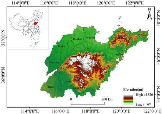
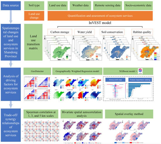
Spatiotemporal Changes, Driving Mechanisms, and Trade-Offs/Synergies of Ecosystem Services in Shandong Province, China
by
Yifei Feng, Likang Chen, Fanchang Meng, Yuyu Liu, Shiguo Xu and Hai Wang
Land 2026, 15(7), 1245; https://doi.org/10.3390/land15071245 - 10 Jul 2026
Abstract
Clarifying how ecosystem services (ESs) change over time and space, and how their trade-offs and synergies evolve, is essential for regional ecological protection and high-quality development. Using Shandong Province as a case study, this research quantified carbon storage (CS), water yield (WY), soil
[...] Read more.
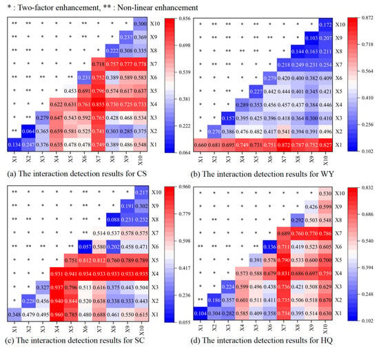
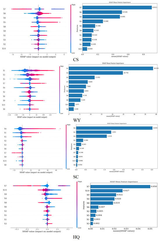
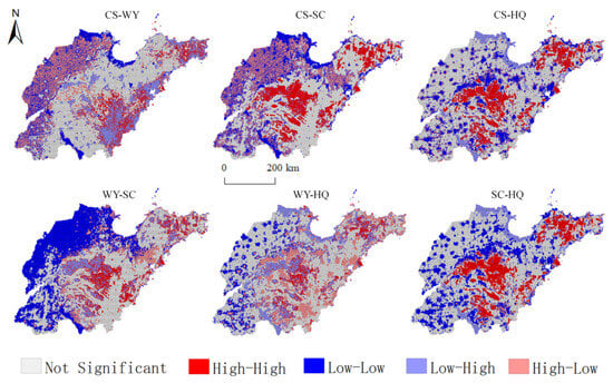
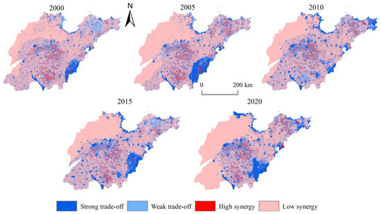
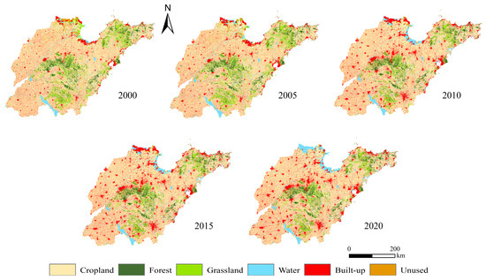
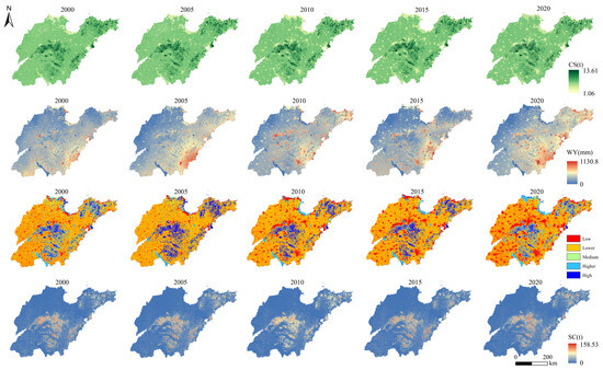
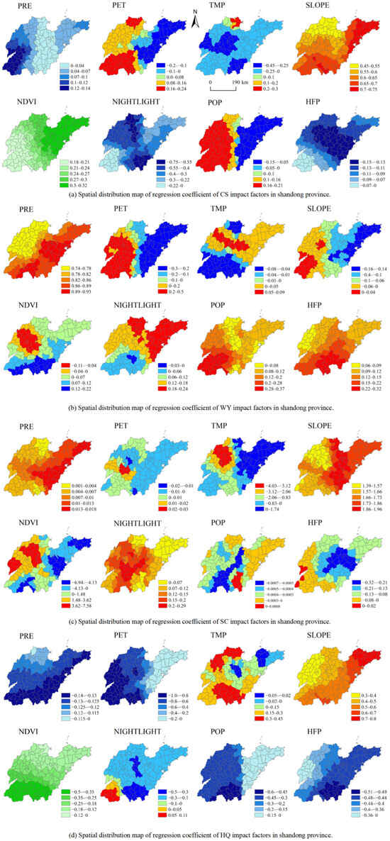
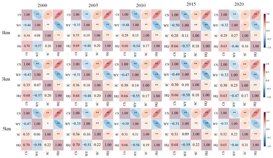
Clarifying how ecosystem services (ESs) change over time and space, and how their trade-offs and synergies evolve, is essential for regional ecological protection and high-quality development. Using Shandong Province as a case study, this research quantified carbon storage (CS), water yield (WY), soil conservation (SC), and habitat quality (HQ) with the InVEST model. GeoDetector, geographically weighted regression (GWR), XGBoost-SHAP, Spearman’s rank correlation, bivariate spatial autocorrelation, and spatial overlay analysis were then combined to examine ES patterns, driving mechanisms, and interaction relationships. The main findings are as follows. (1) During 2000–2020, the most evident land-use changes occurred in cropland, grassland, built-up land, and water bodies. (2) The dominant drivers varied markedly among services: CS and HQ were mainly shaped by land-use type and human activity, WY was chiefly controlled by precipitation, and SC was most sensitive to topographic conditions. Factor interactions were generally stronger than single-factor effects, with two-factor enhancement being the prevailing interaction type. (3) ES trade-off/synergy relationships were relatively stable through time. A strong synergy persisted between CS and HQ, whereas CS and SC exhibited a moderate synergistic relationship. By contrast, WY showed evident trade-offs with both HQ and CS, with the WY–HQ trade-off being particularly pronounced. (4) Spatial overlay results showed that the overall ES synergy level remained low. Low-synergy areas accounted for 69.23–70.94% of the study area across the study period. Although strong-trade-off areas expanded overall, high-synergy areas remained limited, indicating considerable room to improve the coordinated provision of ESs in Shandong Province.
Full article
(This article belongs to the Special Issue Application of the Ecosystem Service in Landscape Planning: From Cognition to Decision-Making (2nd Edition))
►▼
Show Figures

Figure 1
Open AccessArticle
Structural Transformation or Crisis? The Dynamics of Cultivated Land Abandonment and Reuse in China’s Rural Development, 1992–2022
by
Beibei Guo, Ya Fang, Xian Zou, Yingxue Cui, Suchen Ying and Yinkang Zhou
Land 2026, 15(7), 1244; https://doi.org/10.3390/land15071244 - 10 Jul 2026
Abstract
The study investigates whether cultivated land abandonment (CLA) reflects structural transformation or an intensifying crisis. CLA is defined as land that has remained uncultivated for a minimum of two consecutive years, with the exclusion of land that is subject to deliberate programs such
[...] Read more.
The study investigates whether cultivated land abandonment (CLA) reflects structural transformation or an intensifying crisis. CLA is defined as land that has remained uncultivated for a minimum of two consecutive years, with the exclusion of land that is subject to deliberate programs such as the “Grain-for-Green” initiative. Utilizing the China Land Cover Dataset and a moving-window approach, we conducted a comprehensive analysis of spatiotemporal patterns across 2847 Chinese counties from 1992 to 2022. The research employed OLS, Tobit, high-dimensional fixed effects and instrumental variable regressions. The findings of the present study indicate an annual average abandonment rate of 2.3995%, with 12.3649% of cropland abandoned at least once and 9.2028% reclaimed, suggesting a fragile equilibrium. The Huang-Huai-Hai region and Northeast China’s plains emerged as low-abandonment clusters. Cropland fragmentation was found to trigger abandonment, while a higher ecological land ratio significantly exacerbates CLA. Rural labor migration and urbanization drive cumulative abandonment, worsened by the COVID-19 pandemic. Effective governance requires context-specific interventions that address key constraints and integrate land reuse into sustainable rural development frameworks. The research methods and theoretical mechanisms presented offer a reference for balancing food security, rural revitalization, and ecological sustainability worldwide.
Full article
Open AccessArticle
Chain Decomposition Reveals Precipitation-Sensitive Patterns of Ecosystem Carbon–Water Coupling in Karst and Non-Karst Landscapes of Southwest China
by
Yutao He, Shaodong Qu, Suihua Liu and Man Li
Land 2026, 15(7), 1243; https://doi.org/10.3390/land15071243 - 10 Jul 2026
Abstract
Precipitation use efficiency (PUE) links ecosystem carbon uptake to precipitation input, but endpoint ratios alone cannot show where carbon–water coupling differs along ecohydrological pathways. This limitation is especially relevant in karst landscapes, where thin soils and heterogeneous hydrological pathways can decouple rainfall, soil
[...] Read more.
Precipitation use efficiency (PUE) links ecosystem carbon uptake to precipitation input, but endpoint ratios alone cannot show where carbon–water coupling differs along ecohydrological pathways. This limitation is especially relevant in karst landscapes, where thin soils and heterogeneous hydrological pathways can decouple rainfall, soil moisture, evapotranspiration, and plant carbon gain. Here, we developed a PUE chain decomposition framework based on gross primary productivity (GPP), transpiration (T), evapotranspiration (ET), soil moisture (SM), and precipitation (PRE): PUE = GPP/T × T/ET × ET/SM × SM/PRE. In this framework, GPP/T represents carbon fixation per unit transpiration, T/ET the transpiration fraction of evapotranspiration, ET/SM evapotranspiration output relative to soil moisture, and SM/PRE soil moisture status relative to precipitation input. We used multi-source remote-sensing and reanalysis data from 2003 to 2022 to compare karst and non-karst landscapes in Southwest China, applied variance decomposition to quantify the contributions of chain terms and their interactions, and used Stacking ensemble learning with Shapley additive explanations (SHAP) to interpret model-inferred environmental associations. Mean PUE was 1.16 g C m−2 mm−1 in non-karst areas and 1.08 g C m−2 mm−1 in karst areas, and all four chain components differed significantly between landform types. Variance decomposition identified SM/PRE and its interaction terms as the largest contributors to PUE variability, mainly reflecting a precipitation-sensitive diagnostic signal and soil moisture status relative to precipitation input. Machine learning interpretation showed that solar radiation, leaf area index, aridity, and groundwater storage were associated with different chain components; karst areas showed stronger groundwater-storage signals and lower model-inferred response thresholds. These findings indicate that PUE differences in Southwest China arise from multiple linked diagnostic stages rather than from endpoint carbon uptake or precipitation alone. The framework can help locate water-use constraints and support landform-specific ecological restoration and water management.
Full article
(This article belongs to the Special Issue Global Change and Vulnerable Land Ecosystems: Integrated Vegetation–Hydrology–Climate Responses and Policy Implications for Sustainable Land Governance)
Open AccessArticle
Determinants of Women’s Place Attachment in Middle-Income Neighborhoods of Santiago, Chile
by
Asal Kamani Fard, Mohammad Paydar and Pablo Azócar Fernández
Land 2026, 15(7), 1242; https://doi.org/10.3390/land15071242 - 10 Jul 2026
Abstract
Place attachment contributes to urban resilience, identity, and well-being by fostering a sense of belonging and emotional connection to place. In contexts of urban transformation and socio-spatial inequality, understanding its determinants is essential for improving urban livability and inclusive urban environments. This study
[...] Read more.
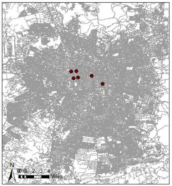
Place attachment contributes to urban resilience, identity, and well-being by fostering a sense of belonging and emotional connection to place. In contexts of urban transformation and socio-spatial inequality, understanding its determinants is essential for improving urban livability and inclusive urban environments. This study examines how women’s place attachment is influenced by individual, social, and built-environment factors in middle-income central and peri-central neighborhoods of Santiago, Chile. A key contribution is the inclusion of personal values in explaining place attachment, extending previous socio-spatial research. Data were collected through simple random sampling from 586 women residing in six middle-income neighborhoods of Santiago. Structural equation modeling was applied to analyze relationships between individual characteristics, personal values, social cohesion, accessibility, and subjective and objective built-environment conditions. Results show that working outside the home, length of residence, personal values, social cohesion, accessibility, aesthetic quality, and perceived comfort and insecurity significantly influence women’s place attachment. Built-environment characteristics related to accessibility and comfort emerge as key mechanisms shaping emotional attachment to urban neighborhoods. Findings highlight the importance of improving accessibility while maintaining neighborhood residential structure in middle-income areas undergoing urban transformation. Overall, the study provides empirical evidence on socio-spatial processes shaping women’s place attachment and contributes to understanding spatial equity, urban well-being, and inclusive urban environments in a Latin American metropolis.
Full article
(This article belongs to the Special Issue Healthy and Inclusive Urban Public Spaces)
►▼
Show Figures

Figure 1
Open AccessArticle
Perspectives for Ecological Restoration in the Agricultural Frontier: Challenges and Possibilities for the Socio-Environmental Conservation of the Brazilian Cerrado
by
Francis Barbosa Rocha and Sérgio Sauer
Land 2026, 15(7), 1241; https://doi.org/10.3390/land15071241 - 10 Jul 2026
Abstract
In 2019, the United Nations’ General Assembly established 2021 to 2030 as the Decade on Ecosystem Restoration, and ecological restoration should be adopted by the member nations. In 2015, Brazil had already committed to restoring (replanting) twelve million hectares of forests, and this
[...] Read more.
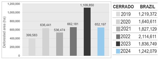
In 2019, the United Nations’ General Assembly established 2021 to 2030 as the Decade on Ecosystem Restoration, and ecological restoration should be adopted by the member nations. In 2015, Brazil had already committed to restoring (replanting) twelve million hectares of forests, and this commitment was reaffirmed in the National Plan for the Recovery of Native Vegetation in 2017 and relaunched at COP16 on diversity in 2024. Despite Brazil’s leadership in establishing the Tropical Forests Forever Fund (TFFF) in 2023, which was launched at COP30 in Belem in 2025, the expansion of the agricultural frontier remains the main driver of deforestation in the Amazon/Rain Forest and the Cerrado biomes. This article aims to examine the social and ecological consequences of the capitalist occupation and expansion of the agricultural frontier in the Cerrado. It will also study the counterpoint of the land struggles and initiatives of peasant organizations focused on conservation and restoration as possibilities and perspectives for the social and ecological restoration of the Cerrado landscapes. Based on an interdisciplinary approach, the specialized literature, and official agricultural data, the study shows that, in addition to degrading nature (deforestation, water and soil contamination, and desertification) and threatening the historical ways of life of countryside peoples, the frontier’s expansion blocks possibilities for restoration and hinders initiatives to protect the remaining nature of Brazil’s second-largest biome. On the other hand, resistance to expropriation and appropriation, and struggles for land and territory, have emerged as possibilities for socio-environmental restoration, beyond reforestation and the recovery of destroyed nature, by transforming landscapes, ways of life, and production, and by creating conditions for food sovereignty and sustainability in the countryside. Therefore, agroecological actions by agrarian movements and rural organizations in general, and those of the Movement of Landless Rural Workers (MST) in particular, have become emblematic in opposing agrarian extractivism and unsustainable monocrops imposed upon and disseminated throughout the Brazilian Cerrado.
Full article
(This article belongs to the Section Land Use, Impact Assessment and Sustainability)
►▼
Show Figures

Figure 1
Open AccessArticle
Highway Landscape Preference Along Malaysia’s North–South Expressway: A Comparison of Multimodal Large Language Models and Human Judgments
by
Hangyu Gao, Richard Smardon, Shamsul Abu Bakar, Suhardi Maulan and Jiani Yang
Land 2026, 15(7), 1240; https://doi.org/10.3390/land15071240 - 9 Jul 2026
Abstract
Visual landscape assessment informs highway corridor planning decisions, yet conventional surveys scale poorly with corridor length. Multimodal large language models (MLLMs) offer a scalable alternative, but their alignment with road-user preferences remains poorly understood. This study aimed to quantify the extent to which
[...] Read more.
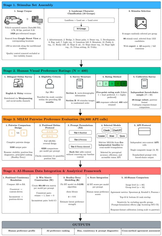
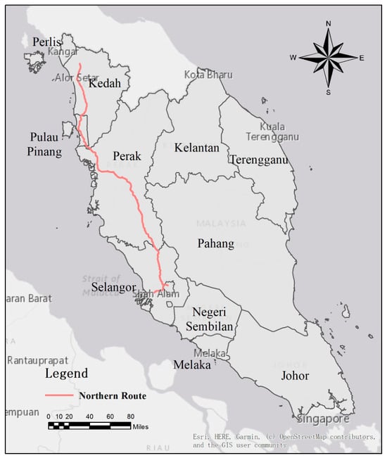
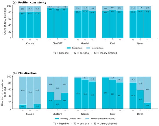
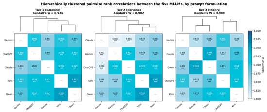
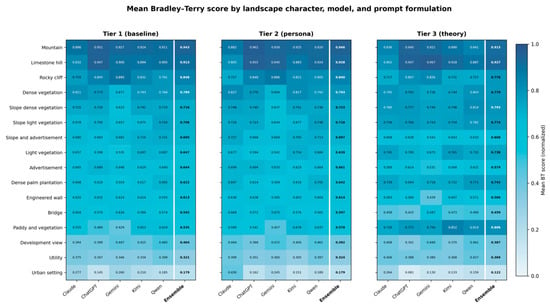
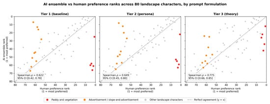
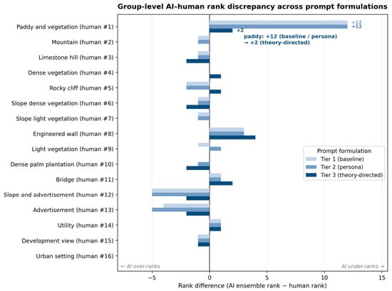
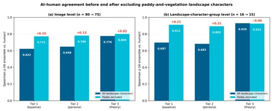
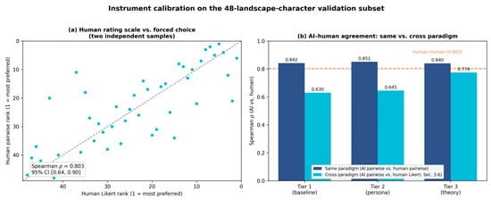
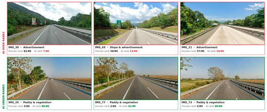
Visual landscape assessment informs highway corridor planning decisions, yet conventional surveys scale poorly with corridor length. Multimodal large language models (MLLMs) offer a scalable alternative, but their alignment with road-user preferences remains poorly understood. This study aimed to quantify the extent to which MLLM-derived visual preference rankings align with those of road users. The comparison used 80 images across 16 landscape character groups along 418 km of Malaysia’s North–South Expressway. Five MLLMs (ChatGPT, Claude, Gemini, Kimi, and Qwen) were queried under three prompt formulations using complete pairwise comparison with AB/BA reversal, yielding 94,800 judgements. Bradley–Terry rankings were then compared against rating-scale responses from 400 road users. The five models converged strongly (Kendall’s W = 0.926), whereas baseline AI–human agreement was moderate (image-level ρ = 0.622; group-level ρ = 0.697). Divergences are concentrated in two opposing categories. Paddy landscapes, ranked first by humans, fell to thirteenth in the AI ranking, whereas advertisement-dominated scenes were overvalued. Excluding the paddy group raised correlations to 0.772 and 0.911. A theory-directed prompt achieved comparable gains (ρ = 0.775 and 0.929) and restored paddy to third rank. A hybrid AI-screening, human-targeted protocol is proposed for corridor-scale visual planning.
Full article
(This article belongs to the Special Issue Urban and Peri-Urban Environment: Searching for Sustainable Planning, Design and Management Solutions)
►▼
Show Figures

Figure 1
Open AccessReview
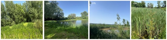
Beyond Water Storage: The Multifaceted Role of Agricultural Ponds in Rural Socio-Ecological Landscapes
by
Chuma Basimine Géant, Marcin Wójcik and Serge Schmitz
Land 2026, 15(7), 1239; https://doi.org/10.3390/land15071239 - 9 Jul 2026
Abstract
Agricultural ponds are often narrowly reduced to water storage units, purification systems, or biodiversity reservoirs, reflecting a dominant yet incomplete perspective that overlooks their role in rural landscapes. By moving beyond that, this study argues that they should be understood as multifunctional socio-ecological
[...] Read more.
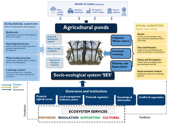
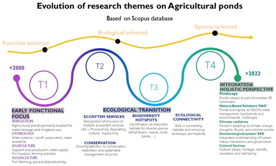
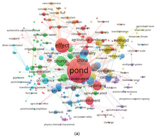
Agricultural ponds are often narrowly reduced to water storage units, purification systems, or biodiversity reservoirs, reflecting a dominant yet incomplete perspective that overlooks their role in rural landscapes. By moving beyond that, this study argues that they should be understood as multifunctional socio-ecological infrastructures embedded within rural territorial dynamics. Their functions extend beyond hydrological and ecological processes to include productive, social, cultural, and landscape-related dimensions. Both utilitarian and aesthetic, agricultural ponds contribute to territorial organisation, support agricultural productivity, sustain rural livelihoods, and shape local socio-ecological interactions. Based on a review of Scopus-indexed literature, this study proposes a reconceptualisation of agricultural ponds through a socio-ecological and landscape perspective. The analysis identifies the main research themes, their evolution, associated functions, and persistent knowledge gaps. Results reveal a fragmented literature, strongly dominated by biophysical approaches that focus on water quality, nutrient cycles, microbial dynamics, and ecosystem processes. Despite increasing methodological sophistication, social and territorial dimensions such as local perceptions, governance systems, practices, and spatial organisation remain marginal. Drawing on empirical illustrations from exploratory investigations of rural villages in Belgium and Poland, the study further highlights the role of agricultural ponds in shaping territorial organisation, identity, and community interactions. These examples demonstrate that pond-related systems are inherently multidimensional and have historically played an underappreciated role in shaping rural landscapes and mediating socio-ecological relationships across scales.
Full article
(This article belongs to the Special Issue Opportunities and Risks for Agriculture and the Environment at Landscape Scales)
►▼
Show Figures

Figure 1
Open AccessArticle
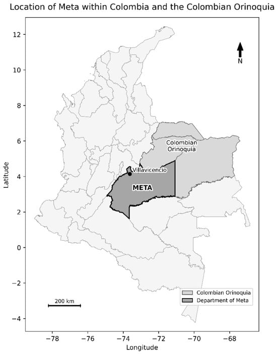
Prioritizing Socioeconomic Impacts of Oil Palm Residue Valorization in Meta, Colombia: A Case from the Orinoquia Region
by
Astrid León-Camargo and Hari Natali Saavedra-Aguirre
Land 2026, 15(7), 1238; https://doi.org/10.3390/land15071238 - 9 Jul 2026
Abstract
The rapid expansion of oil palm cultivation in the Colombian Orinoquia has generated economic benefits but also environmental and social pressures associated with biomass residue management. In this context, residue valorization through bioproduct production has gained relevance as a strategy linked to circular
[...] Read more.
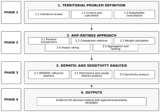
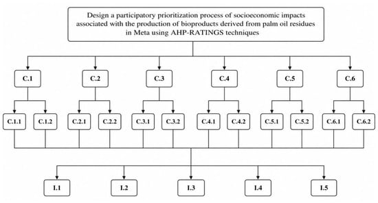
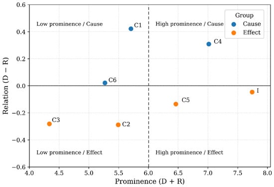
The rapid expansion of oil palm cultivation in the Colombian Orinoquia has generated economic benefits but also environmental and social pressures associated with biomass residue management. In this context, residue valorization through bioproduct production has gained relevance as a strategy linked to circular bioeconomy and regional sustainability. This article analyzes the prioritization of socioeconomic impacts associated with the reuse of oil palm residues in the department of Meta, Colombia, using a participatory multicriteria approach. The method combined the Analytic Hierarchy Process (AHP), the Ratings technique, and the DEMATEL method to evaluate social, economic, and environmental dimensions identified together with territorial stakeholders. The assessment process involved 31 participants representing academia, public institutions, productive sectors, financial entities, and civil society organizations. The results showed greater prioritization of impacts associated with employment generation and local economic development. The DEMATEL analysis revealed that economic and employment-related criteria exerted stronger influence within the evaluated system. Environmental sustainability also reached high relevance, whereas gender equity and post-pandemic regional resilience obtained lower relative weights in the prioritization process.
Full article
(This article belongs to the Special Issue Land Use Optimization for Sustainable Agricultural and Food Systems)
►▼
Show Figures

Figure 1
Open AccessArticle
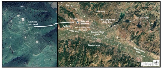
Recovering a Forgotten Wetland in Western Anatolia: Birds and Fish from Second-Millennium BCE Kaymakçı
by
Christina Luke, Tuğçe Yalçın, Safoora Kamjan and Christopher H. Roosevelt
Land 2026, 15(7), 1237; https://doi.org/10.3390/land15071237 - 9 Jul 2026
Abstract
Wetlands sustained some of the most exceptionally dynamic human–environment relationships in past societies. Tracing their presence and ecological characteristics in antiquity requires integrated recovery strategies that link excavation, systematic sampling, and laboratory analysis. This paper presents new zooarchaeological evidence from Middle and Late
[...] Read more.
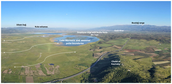
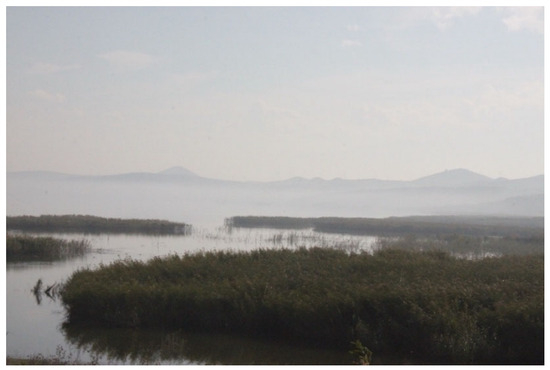
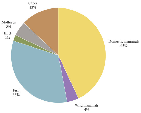
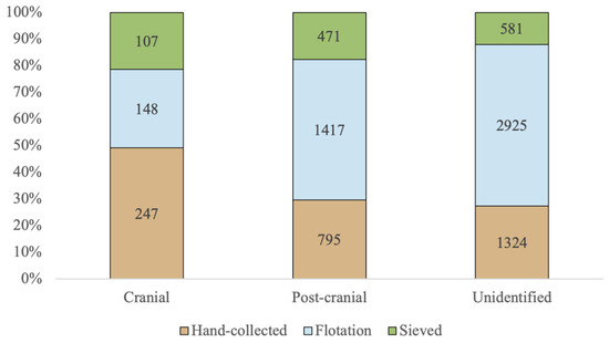
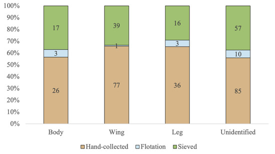
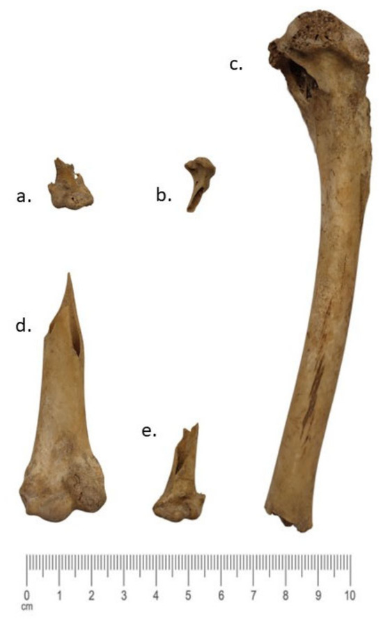
Wetlands sustained some of the most exceptionally dynamic human–environment relationships in past societies. Tracing their presence and ecological characteristics in antiquity requires integrated recovery strategies that link excavation, systematic sampling, and laboratory analysis. This paper presents new zooarchaeological evidence from Middle and Late Bronze Age Kaymakçı in the Marmara Lake Basin of western Türkiye to present evidence of an ancient wetland. Situated in the middle Gediz Valley within a pulse-lake landscape shaped by seasonal flooding, spring discharge, and ecological verticality extending from the basin floor to approximately 2150 m at the peak of Bozdağ, Kaymakçı is currently the largest-known second-millennium BCE settlement not only in this niche zone, but also in wider western Anatolia. The Kaymakçı Archeological Project (KAP) results show that recovery methods, especially heavy fraction, may significantly affect the resulting data and, therefore, the interpretations. The identified fish remains from KAP, dominated by carp and catfish, confirm a large, shallow, vegetated wetland with fluctuating littoral and flood-zone habitats. Bird remains also evidence a taxonomically diverse bird community typical of large wetland zones with nearby mountain ranges, including waterfowl, marsh-edge, and terrestrial taxa. Compared with contemporaneous Anatolian assemblages from central and southeastern regions of Anatolia, the KAP data extend our understanding of seasonally dynamic wetlands in western Anatolia and further confirm the value of integrated faunal analysis.
Full article
(This article belongs to the Special Issue Wetland Biodiversity and Habitat Conservation)
►▼
Show Figures

Figure 1
Open AccessArticle
Developing a Morphology–Structure–Function Coupled Framework to Delineate Critical Stages in Vegetation Restoration Trajectories of Opencast Mine Dump
by
Yanjun Guan, Jinxiu Yan, Kaiyuan Qi, Zhongke Bai and Wenwu Sun
Land 2026, 15(7), 1236; https://doi.org/10.3390/land15071236 - 9 Jul 2026
Abstract
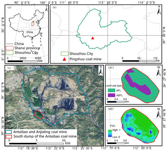
The reconstruction of vegetation in opencast mining areas constitutes an intricate process of ecological restoration within human-altered systems. A systematic characterization of the multi-dimensional synergistic successional pathways—encompassing morphology, structure, and function—and the corresponding delineation of key recovery phases holds significant potential to inform
[...] Read more.
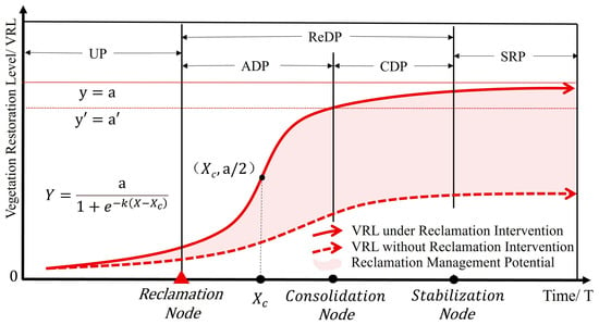
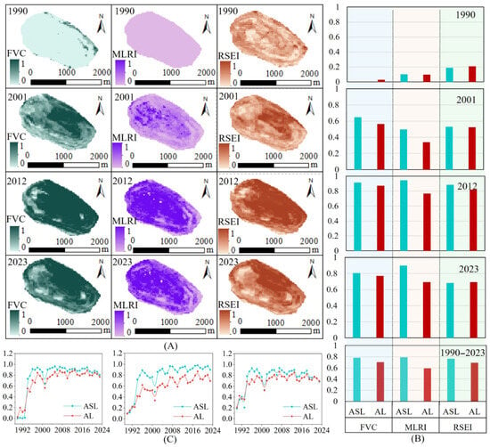
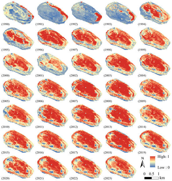
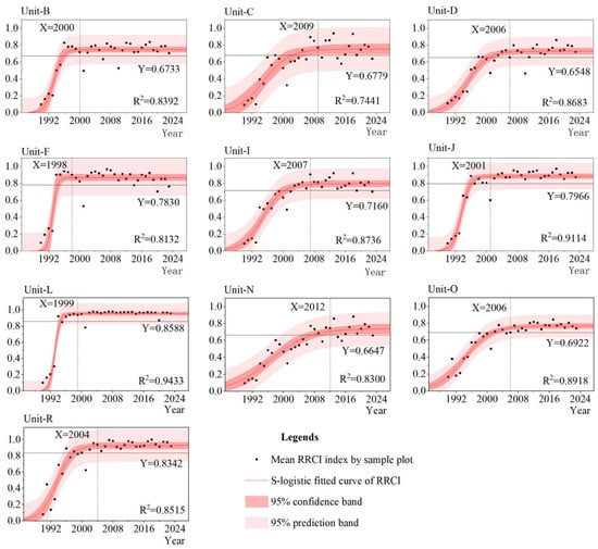
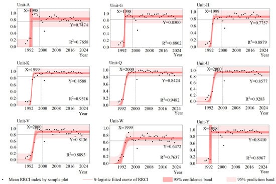
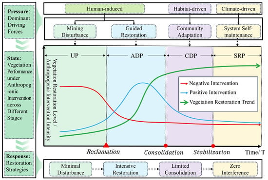
The reconstruction of vegetation in opencast mining areas constitutes an intricate process of ecological restoration within human-altered systems. A systematic characterization of the multi-dimensional synergistic successional pathways—encompassing morphology, structure, and function—and the corresponding delineation of key recovery phases holds significant potential to inform and refine land reclamation strategies. This study took the southern dump of the Antaibao Coal Mine within the Pingshuo mining area on the Loess Plateau as the study area. Using the Google Earth Engine (GEE) platform, time series Landsat remote sensing images from 1990 to 2023 were processed to derive three indicators representing vegetation coverage morphology, landscape pattern structure, and ecosystem service function: Vegetation Fractional Coverage (VFC), Mining Landscape Restoration Index (MLRI), and Remote Sensing Ecological Index (RSEI). A Reconstructed vegetation Restoration Comprehensive Index (RRCI) was established through the multi-dimensional collaborative analysis of morphology–structure–function. Based on the long-term evolutionary sequence of RRCI, the S-logistic growth curve model was employed for nonlinear fitting, and critical restoration stages of reconstructed vegetation were quantitatively delineated using preset threshold rules. The results demonstrate that time series RRCI data of the screened sample plots effectively characterize the spatiotemporal restoration dynamics of reconstructed vegetation, with a high model goodness of fit (R2 > 0.7). In accordance with the criteria for delineating critical stages of reconstructed vegetation restoration, the average durations of the accelerated development period, consolidation development period, and overall recovery development period of reconstructed vegetation in the study area are 5.09 years, 4.64 years, and 9.73 years, respectively. Significant differences exist in the accelerated development period and overall recovery development period between arbor forest lands and arbor shrub forest lands (p < 0.05), and the time required for vegetation restoration at each stage is longer in arbor forest lands than in arbor shrub forest lands. This study constructs a multi-dimensionally collaborative RRCI and quantifies critical stages of reconstructed vegetation evolution, which is of great significance for promoting the sustainable evolution and dynamic management of reconstructed vegetation in opencast mining areas.
Full article
(This article belongs to the Special Issue Land Use Change and Technological Innovations: Remote Sensing and Artificial Intelligence Approaches)
►▼
Show Figures

Figure 1
Open AccessArticle
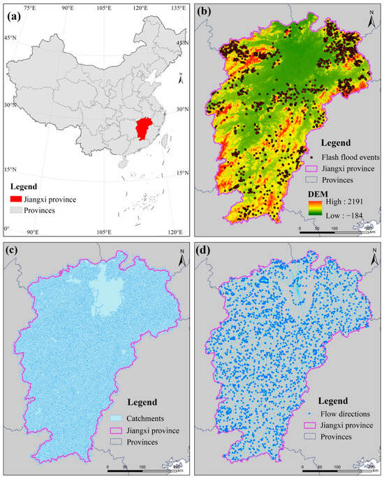
Identifying Homogeneous Regions for Flash Floods Using Graph Clustering Neural Networks in Jiangxi Province, China
by
Yuehong Chen, Yunqiang Li, Xiaoxiang Zhang and Qiang Ma
Land 2026, 15(7), 1235; https://doi.org/10.3390/land15071235 - 9 Jul 2026
Abstract
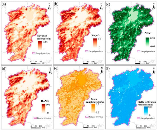
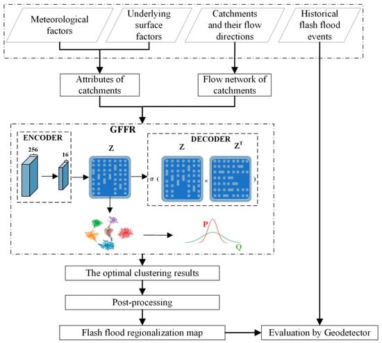
Identifying homogeneous flash flood regions through regionalization is essential for effective mitigation and prevention. However, most existing regionalization methods focus primarily on attribute similarity (e.g., meteorological and underlying factors), while ignoring structural similarity that reflects topological network and flow relationships among catchments. In
[...] Read more.
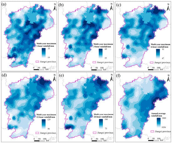
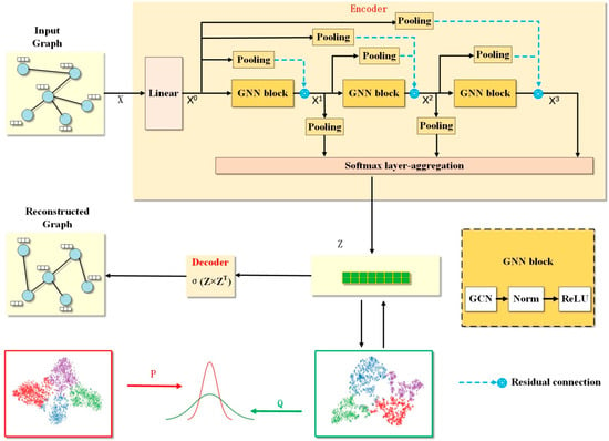
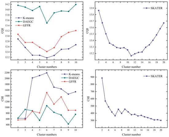
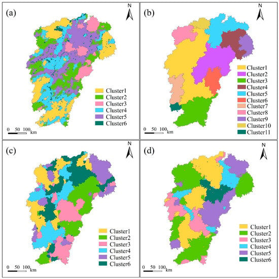
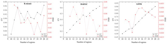
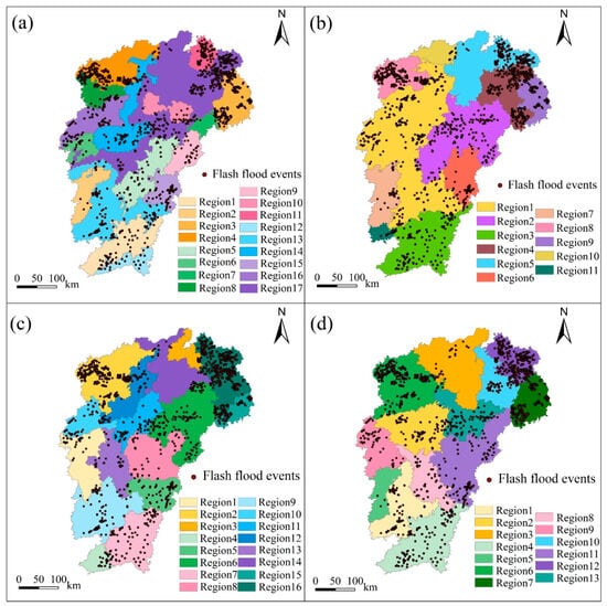
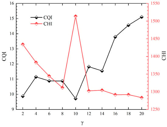
Identifying homogeneous flash flood regions through regionalization is essential for effective mitigation and prevention. However, most existing regionalization methods focus primarily on attribute similarity (e.g., meteorological and underlying factors), while ignoring structural similarity that reflects topological network and flow relationships among catchments. In this study, we developed a new graph-clustering-neural-network-based flash flood regionalization (GFFR) method to address these limitations and improve the homogeneous region delineation. Catchments were first represented as a directed graph. Within GFFR, we then designed a graph convolutional autoencoder to learn latent representations that capture both catchment structure and attributes, while a decoder grouped the catchments into clusters. GFFR was applied in Jiangxi province, China, where it outperformed three typical clustering methods. Historical flash flood events were used to validate the GFFR map, presenting strong spatial consistency with dense event clusters and achieving a determinant power of 81%. Furthermore, the GFFR achieved a 24% higher determinant power than the average performance of the three compared methods. Overall, GFFR provides a valuable tool for flash flood regionalization, while the delineated regions offer critical guidance for governmental flash flood prevention and mitigation strategies.
Full article
(This article belongs to the Special Issue Regional Sustainable Development of Yangtze River Delta, China—Fourth Edition)
►▼
Show Figures

Figure 1
Open AccessArticle
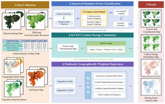
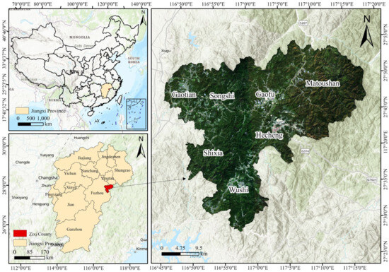
Fusing Multi-Source Remote Sensing Data and MGWR to Unravel Spatial Heterogeneity of Bamboo Forest Carbon Stocks in Mountainous Regions: A Case from Zixi, China
by
Hanchu Yu, Yue Zhou, Yuqian Yan and Hongsheng Huang
Land 2026, 15(7), 1234; https://doi.org/10.3390/land15071234 - 8 Jul 2026
Abstract
►▼
Show Figures
Quantifying mountain forest carbon stocks and elucidating their spatially heterogeneous driving mechanisms are both critical for terrestrial carbon management under the global carbon neutrality agenda. Conventional single-source remote sensing approaches can neither fully exploit multi-source data synergies nor adequately resolve spatial heterogeneity in
[...] Read more.
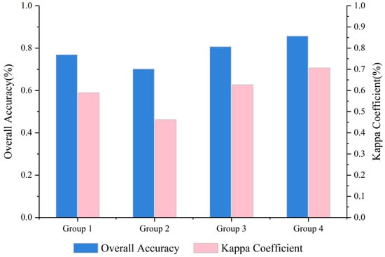
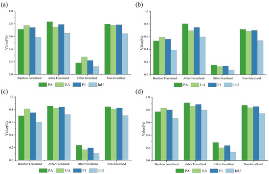
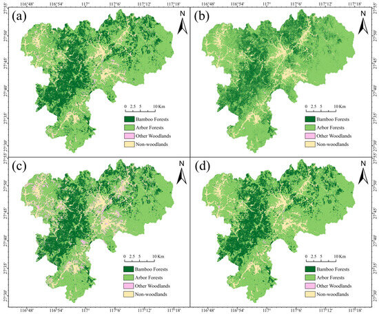
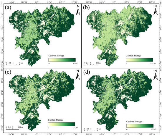
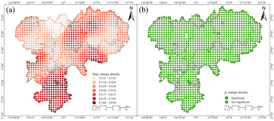
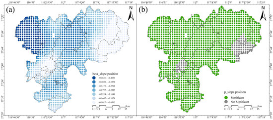
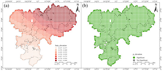
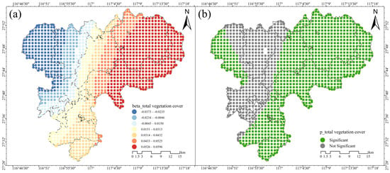
Quantifying mountain forest carbon stocks and elucidating their spatially heterogeneous driving mechanisms are both critical for terrestrial carbon management under the global carbon neutrality agenda. Conventional single-source remote sensing approaches can neither fully exploit multi-source data synergies nor adequately resolve spatial heterogeneity in complex terrains. This study develops an integrated framework combining multi-source remote sensing classification, InVEST-based carbon estimation, and multiscale geographically weighted regression (MGWR) and applies it to Zixi County, a subtropical mountainous bamboo-abundant region in southeastern China. Sentinel-2 imagery, PlanetScope data, and DEM derivatives were fused with an optimized Random Forest classifier, achieving an overall accuracy of 0.8565 (Kappa = 0.7065). Carbon stocks were then estimated via the InVEST model. MGWR analysis (adjusted R2 = 0.930, AICc = 594.032) substantially outperformed the global OLS model (adjusted R2 = 0.795, AICc = 1717.450), confirming strong spatial non-stationarity across all drivers. Canopy density exhibited the strongest positive local effect (coefficient range: 0.343–0.768); slope position showed predominantly negative regulation with localized positive reversals (−0.778 to 0.270); elevation displayed a broad-scale positive gradient (0.133–0.140); and total vegetation cover exhibited bidirectional effects (−0.134 to 0.208) with pronounced east–west divergence. This framework not only provides a robust methodological reference for carbon stock assessment in complex mountain landscapes but also supports targeted forest management and carbon sequestration strategies through spatially explicit driver identification.
Full article

Figure 1
Open AccessArticle
Land Use Carbon Budget Evolution and Functional Spatial Associations: An Empirical Analysis of the Pearl River Delta Urban Agglomeration in China
by
Wei Xuan and Yan Xu
Land 2026, 15(7), 1233; https://doi.org/10.3390/land15071233 - 8 Jul 2026
Abstract
Rapid urban expansion has increasingly reshaped the carbon budgets of urban agglomerations through land use change. However, the role of functional heterogeneity within construction land remains insufficiently considered when examining the spatial differentiation of construction expansion-related carbon increases. Using the Pearl River Delta
[...] Read more.
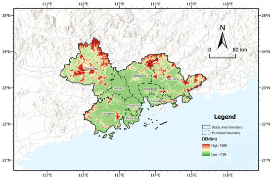
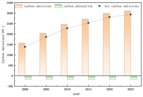
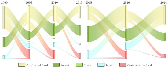
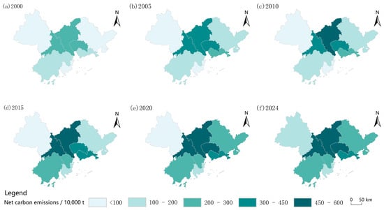
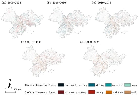
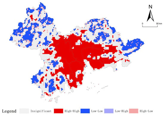
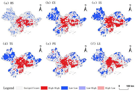
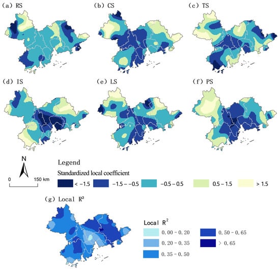
Rapid urban expansion has increasingly reshaped the carbon budgets of urban agglomerations through land use change. However, the role of functional heterogeneity within construction land remains insufficiently considered when examining the spatial differentiation of construction expansion-related carbon increases. Using the Pearl River Delta Urban Agglomeration in China as the study area, this research traced the spatiotemporal changes in land use carbon budgets between 2000 and 2024, evaluated how the expansion of construction land contributed to the growth of regional carbon emissions, and further examined the spatial associations between six construction land functional categories and expansion-related carbon increases over the period of 2010–2024. The results show the following. (1) During 2000–2024, approximately 15,200 km2 of land experienced use transitions, representing 28.2% of the regional land area. These transitions generated an accumulated increase of 15.46 million t in net carbon emissions, largely driven by the conversion of cultivated land, forest land, and other non-construction land into construction land. (2) Approximately 96.2% of the carbon increase from land use transitions was attributed to the conversion of other land use types into construction land, confirming construction land expansion as the dominant pathway of regional carbon increases. (3) From 2010 to 2024, expansion-related carbon increases showed significant spatial clustering, with high-value clusters mainly concentrated in the Guangzhou–Foshan–Dongguan–Shenzhen corridor and low-value clusters in peripheral areas. (4) Functional space variables were further associated with the spatial differentiation of carbon increases. Industrial and transportation spaces showed the strongest spatial associations, and their interaction showed the strongest explanatory effect, while GWR results revealed stronger local associations in peripheral areas and weaker associations in core areas. These findings provide empirical support for carbon-focused land use governance, functional optimization of construction land, and differentiated territorial spatial regulation in rapidly urbanizing urban agglomerations.
Full article
(This article belongs to the Special Issue Carbon-Focused Land Use Strategies: Pathways to Climate Resilience)
►▼
Show Figures

Figure 1
Open AccessArticle
Spatial Differentiation and Mechanisms of Spatial Mismatch Between Traditional Villages and Intangible Cultural Heritage: Collaborative Conservation Zoning and Strategies in Anhui Province, China
by
Wenzhe Wang, Xiaorui Zhang, Yeyang Han and Chenhao Fu
Land 2026, 15(7), 1232; https://doi.org/10.3390/land15071232 - 8 Jul 2026
Abstract
Traditional villages and intangible cultural heritage (ICH) are interrelated components of rural heritage landscapes, linking material spatial carriers with living cultural practices. Yet their spatial matching, mismatch-formation mechanisms, and translation into collaborative conservation zoning remain insufficiently understood. Taking Anhui Province, China, a north–south
[...] Read more.
Traditional villages and intangible cultural heritage (ICH) are interrelated components of rural heritage landscapes, linking material spatial carriers with living cultural practices. Yet their spatial matching, mismatch-formation mechanisms, and translation into collaborative conservation zoning remain insufficiently understood. Taking Anhui Province, China, a north–south transitional region, this study examines 836 traditional villages and 685 ICH items at or above the provincial level. We develop a stepwise spatial diagnostic framework that connects clustering identification, positional and quantity–structure mismatch diagnosis, corridor and multi-factor association interpretation, and strategy-oriented conservation zoning. The results show that traditional villages form a strong southern Anhui core (83.01%), whereas the officially attributed locations of listed ICH items are more widely distributed across southern, central, and northern Anhui (43.21%, 26.42%, and 30.36%). The provincial centroid mismatch distance reaches 160.15 km, and prefecture-level cities are classified into ICH-advantaged, traditional-village-advantaged, and relatively matched types. Huangshan further demonstrates that positional proximity does not necessarily imply quantity-structure matching. Mechanism analysis suggests two scale-dependent association patterns: an environmental preservation pattern for traditional villages and a social-transmission and institutional-attribution pattern for listed ICH items. Based on this provincial-scale diagnosis, the study delineates key, secondary, and general conservation zones as strategy-oriented diagnostic zones and proposes differentiated collaborative conservation strategy orientations.
Full article

(This article belongs to the Special Issue Monitoring and Modelling Human–Environment Interactions in Urban–Rural Areas)
Open AccessArticle
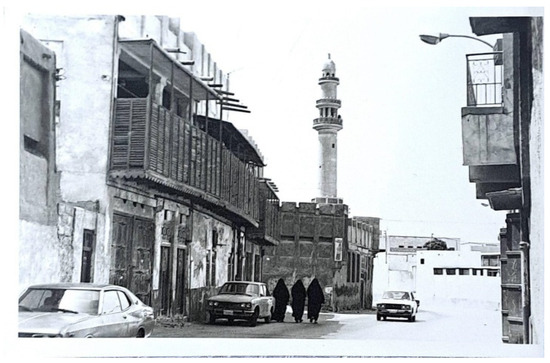
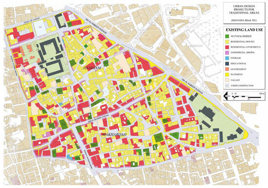
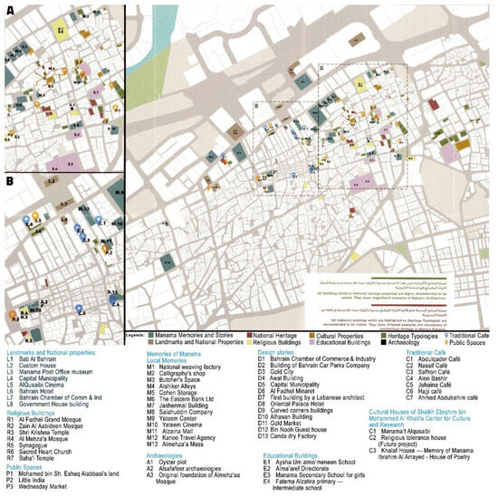
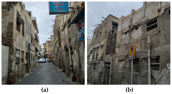
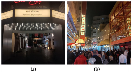
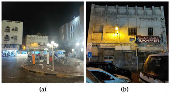
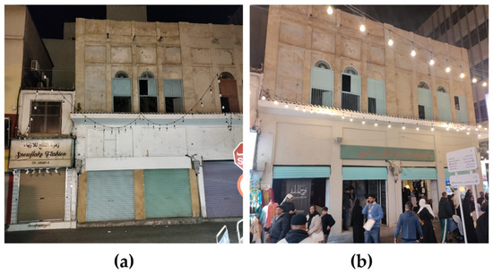
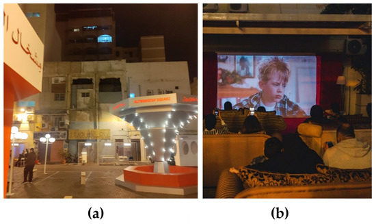
The Metamorphosis of Manama: Sustainable Integration of Leftover Heritage Buildings Through the Historic Urban Landscape (HUL) Approach
by
Saad Hanif, Nazish Abid and Abbas Abdo Al Warafi
Land 2026, 15(7), 1231; https://doi.org/10.3390/land15071231 - 8 Jul 2026
Abstract
This study examines how the Historic Urban Landscape (HUL) approach, proposed by UNESCO, can support the integration of leftover heritage buildings while balancing conservation with sustainable urban development. Furthermore, it investigates how the HUL approach can contribute to Manama’s ongoing efforts toward UNESCO
[...] Read more.
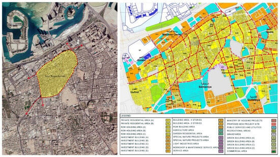
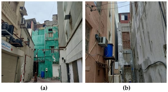
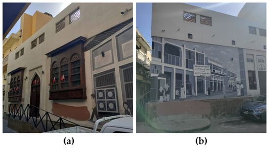
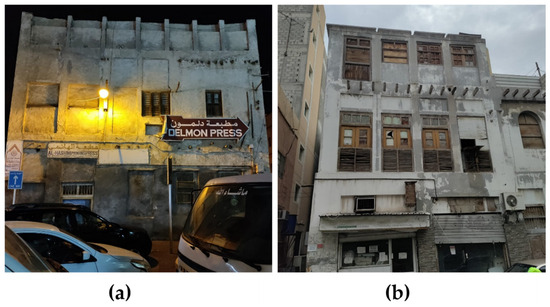
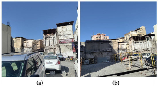
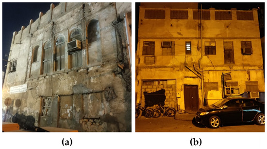
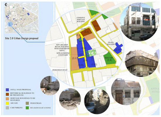
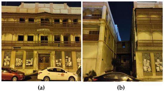
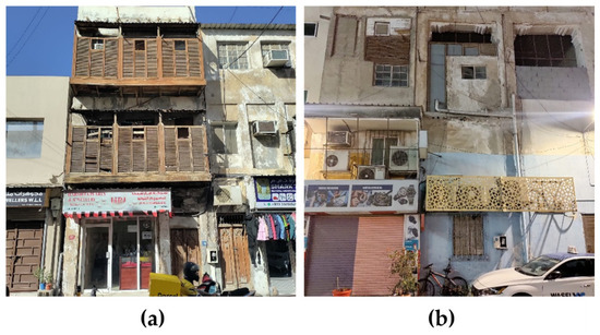
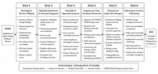
This study examines how the Historic Urban Landscape (HUL) approach, proposed by UNESCO, can support the integration of leftover heritage buildings while balancing conservation with sustainable urban development. Furthermore, it investigates how the HUL approach can contribute to Manama’s ongoing efforts toward UNESCO World Heritage inscription aligning with the Vision 2030. The research adopts an exploratory case study methodology, utilizing qualitative research techniques including document analysis and fieldwork. The data analysis follows the six-step process of HUL, which focuses on managing and safeguarding these leftover heritage buildings as part of urban heritage, while field observations provide direct evidence of physical deterioration and underutilization. The analysis reveals persistent fragmentation within the historic core of Manama, despite multiple conservation phases led by state authorities. Findings highlight that, while the heritage buildings were deprioritized during the post-modernization era, their integration through the HUL approach can act as a catalyst in sustainable urban development. By providing a framework, findings illustrate that such integration will enhance socio-economic vitality, contributing to Manama’s UNESCO inscription, after being on the tentative list for nearly a decade. The research findings are anticipated to inform Bahrain’s Development Strategy of the Vision 2030, which emphasizes continuous strategic planning to guide policy decisions, emphasizing sustainability-oriented planning that responds to national opportunities and constraints.
Full article

(This article belongs to the Special Issue Reframing Urban Morphology: Heritage, Sustainability, and Contemporary Urban Transformation)
►▼
Show Figures

Figure 1
Open AccessArticle
Forecasting Urban Heat Island Intensification in Arkansas, USA, Using the XGBoost Machine Learning
by
Rasool Vahid and Mohamed H. Aly
Land 2026, 15(7), 1230; https://doi.org/10.3390/land15071230 - 8 Jul 2026
Abstract
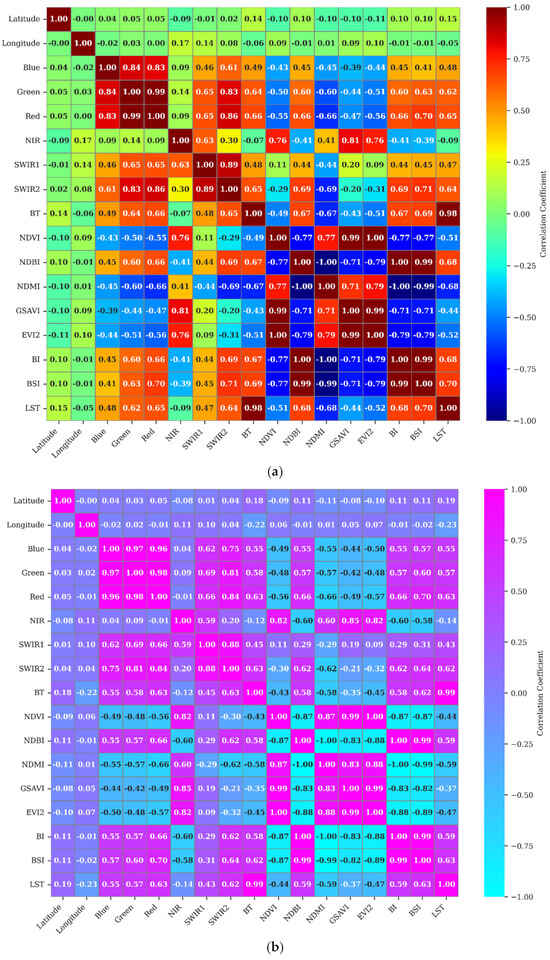
Urban heat islands (UHIs) significantly influence microclimatic conditions, energy consumption, and public health. This research leverages ensemble models and correlation analysis based on Landsat 5-8 satellite data to forecast LST and explore its environmental relationships. This study employed the XGBoost machine learning algorithm
[...] Read more.
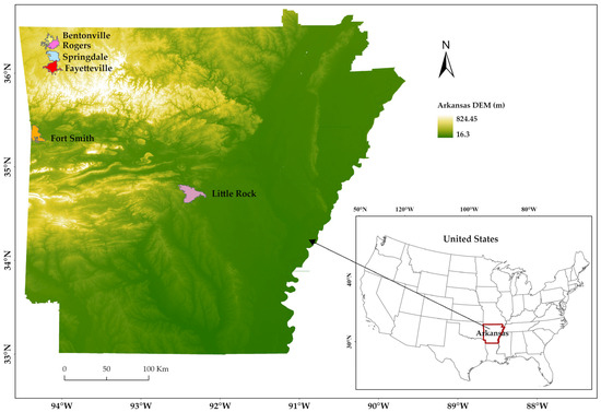
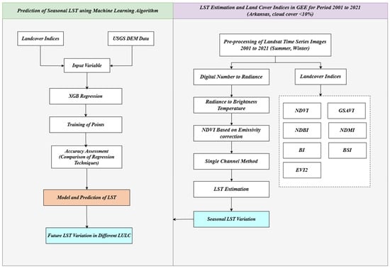
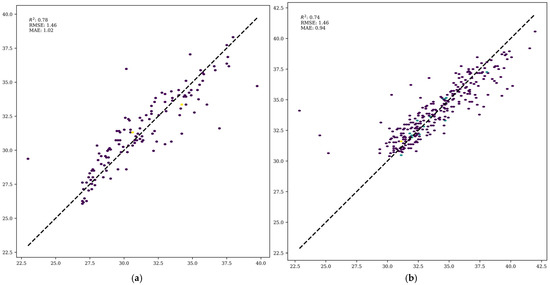
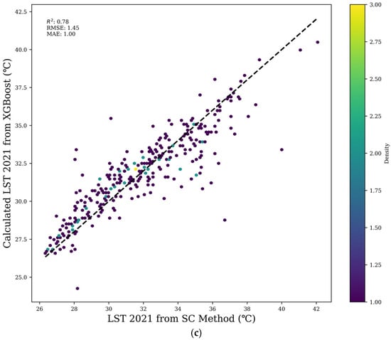
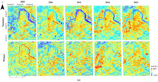
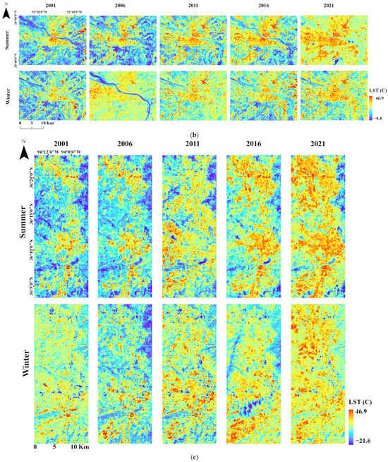
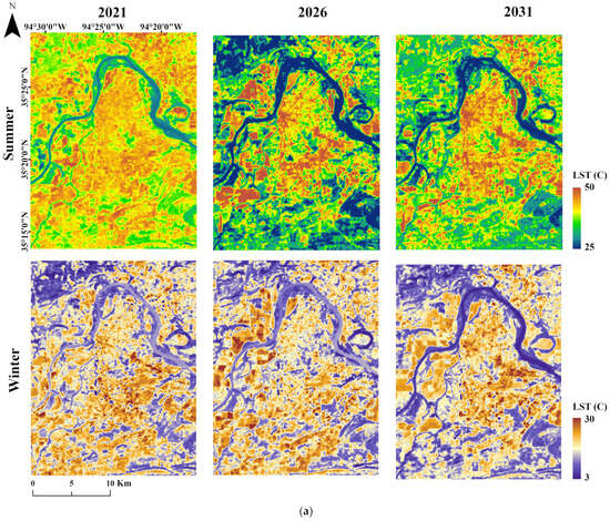
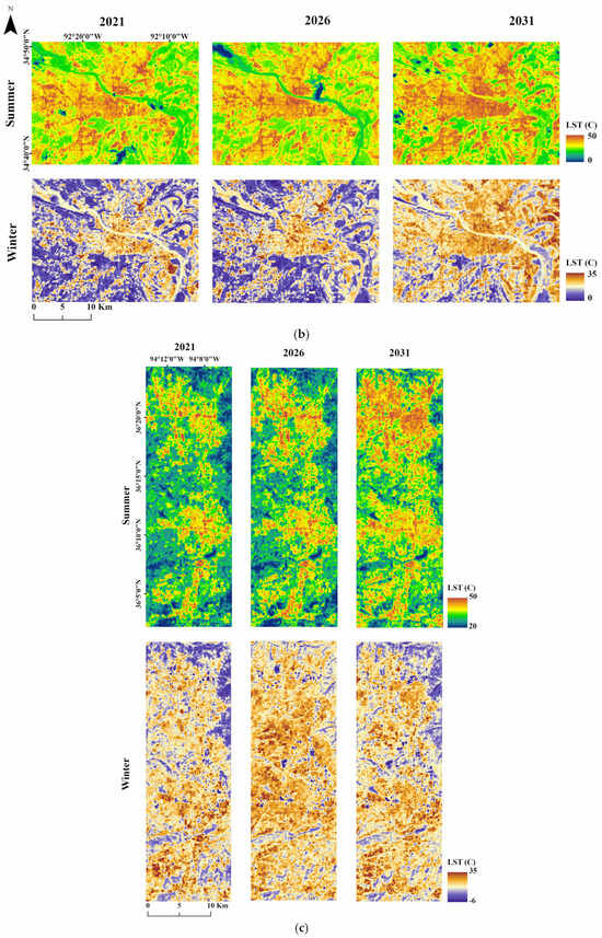
Urban heat islands (UHIs) significantly influence microclimatic conditions, energy consumption, and public health. This research leverages ensemble models and correlation analysis based on Landsat 5-8 satellite data to forecast LST and explore its environmental relationships. This study employed the XGBoost machine learning algorithm to model seasonal LST dynamics in three rapidly urbanizing Arkansas cities, including Fort Smith, Little Rock, and Northwest Arkansas, using Landsat imagery from 2001 to 2021. The results show significant increases in urban heat, particularly in the summer, with Fort Smith seeing an increase in the area classified in higher-temperature bins (35–45 °C) from approximately 33% in 2001 to more than 83% by 2021. Model validation showed high predictive performance (R2 = 0.74–0.78, RMSE ≤1.46 °C), indicating reliable project-based estimation of spatial LST variability for 2026 and 2031. The results revealed a substantial intensification of built-up area expansion, to 9.8% by 2026 and 20.7% by 2031, accompanied by cropland reductions of 13.2% and 25.5%, respectively. This rapid urban growth is projected to elevate summer LSTs above 45 °C across more than 700 km2 combined, and winter LSTs to ≥25 °C across nearly 125 km2 in the region by 2031. The integration of Landsat time series data and machine learning provide valuable insights for urban planners and policymakers, underscoring the critical importance of targeted climate-resilient strategies and sustainable urban development practices.
Full article
(This article belongs to the Special Issue Advances in AI and Geospatial Analytics for Land Use and Cover Change Modelling)
►▼
Show Figures

Figure 1
Open AccessArticle
Resilience Assessment, Type Identification and Spatial Zoning of Traditional Villages from a Tripartite Attribute Perspective: A Case Study of Jincheng City, Shanxi Province, China
by
Xue Wang and Kai Cui
Land 2026, 15(7), 1229; https://doi.org/10.3390/land15071229 - 8 Jul 2026
Abstract
►▼
Show Figures
Rapid urbanization and the urban-rural dualism are subjecting traditional villages to various slow-onset disturbances. The resilience of traditional villages (RTV) has become essential for their sustainable development. By measuring, classifying, and zoning RTV, this study aims to reveal its actual state and heterogeneous
[...] Read more.
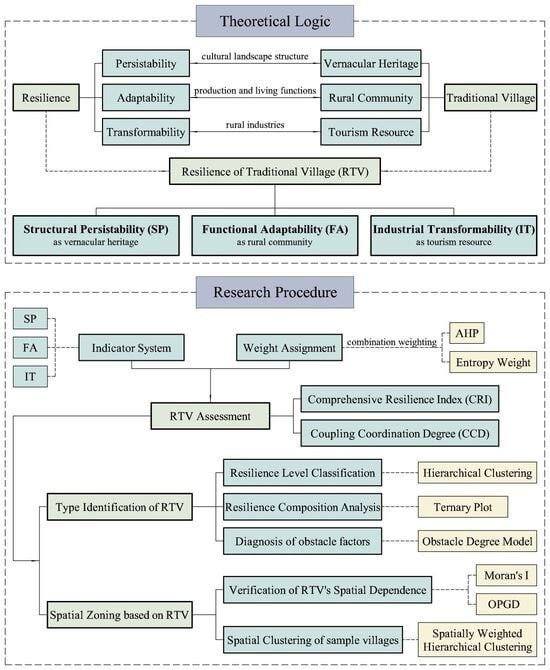
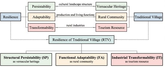
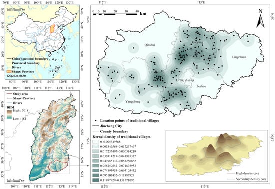
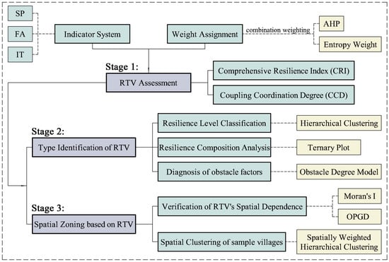
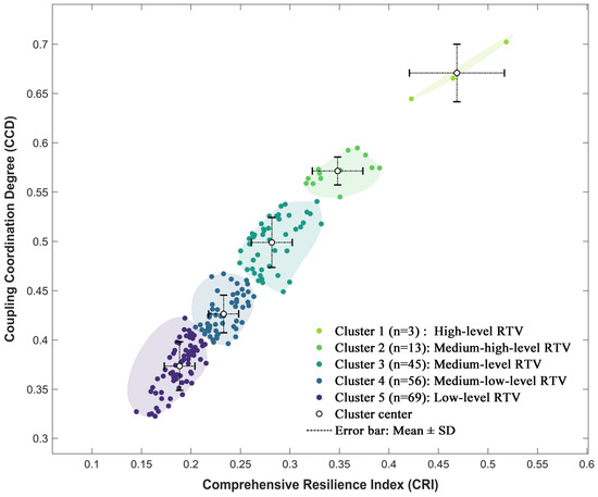
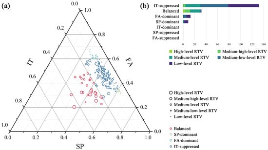
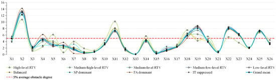
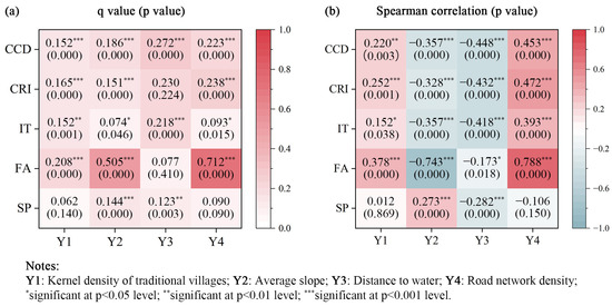
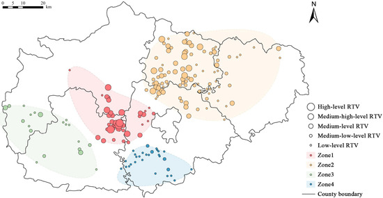
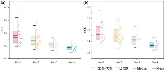
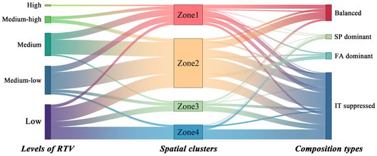
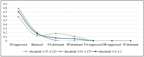
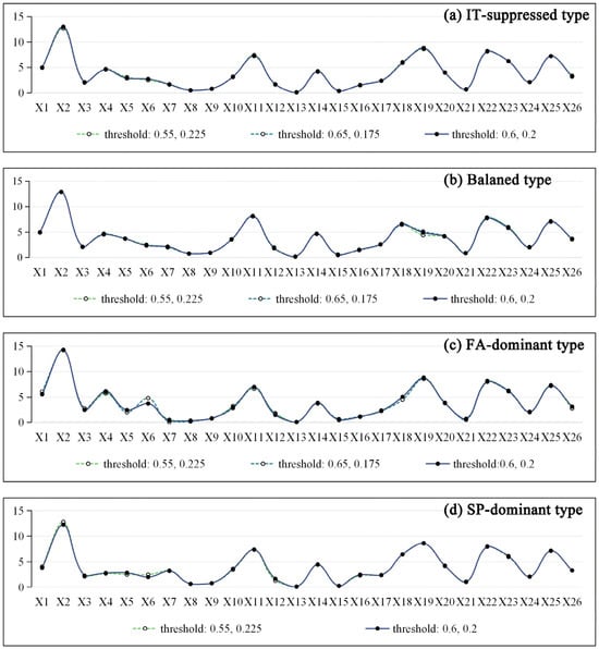
Rapid urbanization and the urban-rural dualism are subjecting traditional villages to various slow-onset disturbances. The resilience of traditional villages (RTV) has become essential for their sustainable development. By measuring, classifying, and zoning RTV, this study aims to reveal its actual state and heterogeneous characteristics, thereby offering clear guidance for differentiated sustainable development strategies in traditional villages. From an integrated perspective of the tripartite attributes of traditional villages, this study develops an RTV assessment framework comprising three dimensions: structural persistability (SP) as vernacular heritage, functional adaptability (FA) as rural communities, and industrial transformability (IT) as tourism resources. Using hierarchical clustering, the obstacle degree model, the optimal parameters-based geographical detector, and spatially weighted hierarchical clustering, this study identifies distinct RTV types, along with their statistical distributions, key constraints, and spatial patterns. The main conclusions are as follows. (1) Most traditional villages in Jincheng exhibit low or medium-low levels of resilience. Moreover, the three dimensions of RTV are unevenly developed, with the IT dimension lagging markedly behind the others. (2) The key obstacles to enhancing RTV are the scarcity of high-value heritage resources, insufficient public services, low regional socioeconomic vitality, low public visibility, a scarcity of high-quality tourism assets, inadequate tourism support facilities, and a limited local tourism supply market. (3) Jincheng’s traditional villages cluster into four resilience-based zones, enabling a regional approach to their conservation.
Full article
Graphical abstract
Open AccessArticle
Spatiotemporal Patterns and Socio-Ecological Drivers of Coastal Wetland Landscape Fragmentation in Yancheng, Jiangsu
by
Jie Wang, Yitao Zhou and Liang Fang
Land 2026, 15(7), 1228; https://doi.org/10.3390/land15071228 - 8 Jul 2026
Abstract
►▼
Show Figures
The coastal wetlands of Yancheng, Jiangsu Province, serve as a crucial overwintering and stopover site for rare waterbirds such as red-crowned cranes. The changes in their landscape pattern are directly related to the protection of regional wetland ecological functions and biodiversity. Using land
[...] Read more.
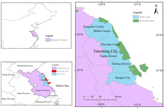
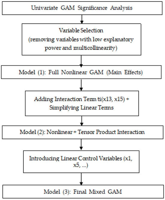
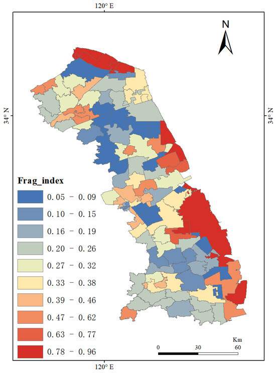
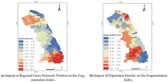
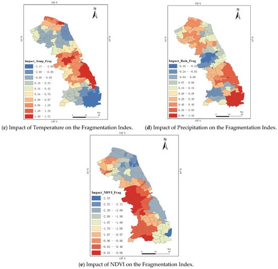
The coastal wetlands of Yancheng, Jiangsu Province, serve as a crucial overwintering and stopover site for rare waterbirds such as red-crowned cranes. The changes in their landscape pattern are directly related to the protection of regional wetland ecological functions and biodiversity. Using land use data from 2010 to 2022 to extract landscape pattern indicators for each period, this study adopts the Covariance–Analytic Hierarchy Process (Cov-AHP) to construct a comprehensive Landscape Fragmentation Index (LFI) for coastal wetlands, considering aspects including patch density, boundary complexity, spatial connectivity, and landscape diversity. Combined with multi-source indicators of Ecology–Economy–Society (EES), the Generalized Additive Model (GAM) and Geographically Weighted Regression (GWR) are adopted to systematically analyze the nonlinear response relationships and spatially heterogeneous driving mechanisms of landscape fragmentation. GWR is employed to reveal the spatial heterogeneity of the influence of each driving factor on fragmentation by mapping local regression coefficients. The results show that: (1) During the study period, the overall landscape fragmentation of the coastal wetlands in Yancheng, Jiangsu Province, exhibited a slow increase trend, with a spatial gradient pattern of “higher in the north and lower in the south, and higher in coastal areas than in inland areas,” reflecting the combined effects of varying levels of economic development and human activity intensity across different administrative regions and along the coast-inland gradient. (2) Based on the deviance explained by the GAMs, social factors generally had higher explanatory power for LFI than ecological and economic factors. Specifically, human population density and the proportion of construction land showed a significant positive correlation with LFI, while NDVI and the proportion of farmland exhibited obvious nonlinear effects under different fragmentation levels. (3) The GWR results indicated that the regression coefficients of the main driving factors were highly spatially non-stationary, and regions with high coastal development intensity had the most significant promoting effect on landscape fragmentation. The local coefficient maps further reveal that GDP and NDVI exhibit the strongest spatial heterogeneity, with their effects shifting from positive to negative across different sub-regions. The study demonstrates that the integrated framework of Cov-AHP combined with GAM and GWR can effectively characterize the spatiotemporal dynamics and multi-dimensional driving mechanisms of coastal wetland landscape fragmentation, providing a reference for the protection of coastal wetlands in Yancheng, Jiangsu Province, and the conservation of waterbird habitats represented by red-crowned cranes.
Full article
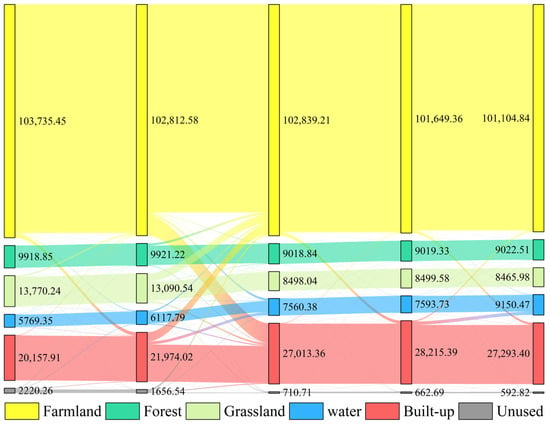
Figure 1
Open AccessArticle
Remote/Relict Marine Sediment Deposits: A First Attempt at Quantitative Evaluation of the Resource in Sicily (Italy)
by
Stefania Lanza, Diego Paltrinieri, Giovanni Randazzo and Francesco Gregorio
Land 2026, 15(7), 1227; https://doi.org/10.3390/land15071227 - 8 Jul 2026
Abstract
Sicily is a Mediterranean island region whose economy is based especially on tourism, with tourists being attracted to its beaches. The whole coastline of the island, including its minor islands, is 1745 km. At the moment, considering the whole period analyzed by the
[...] Read more.
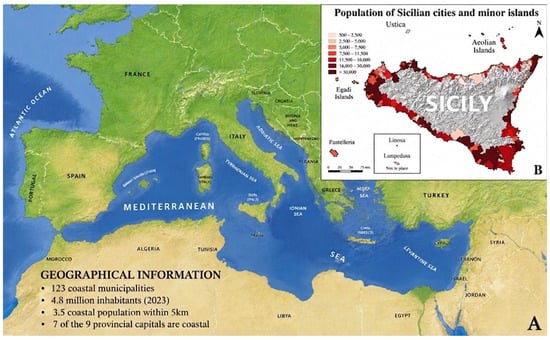
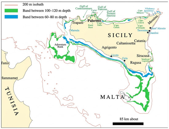
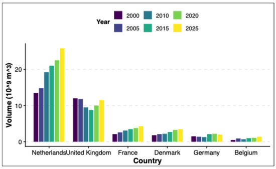
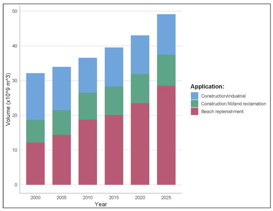
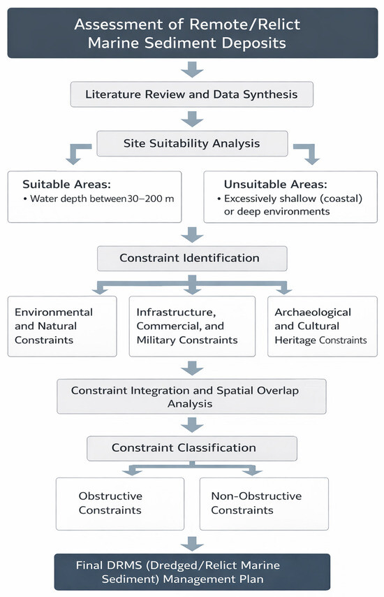
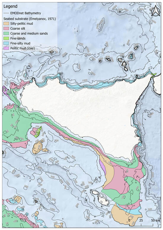
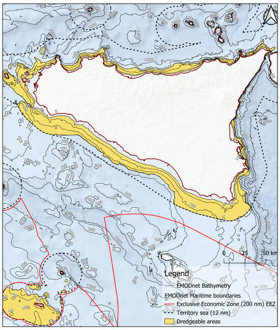
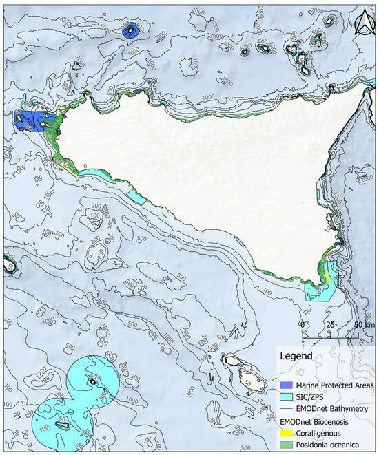
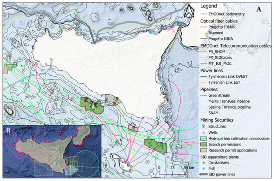
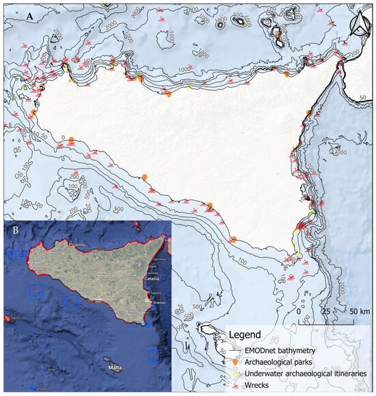
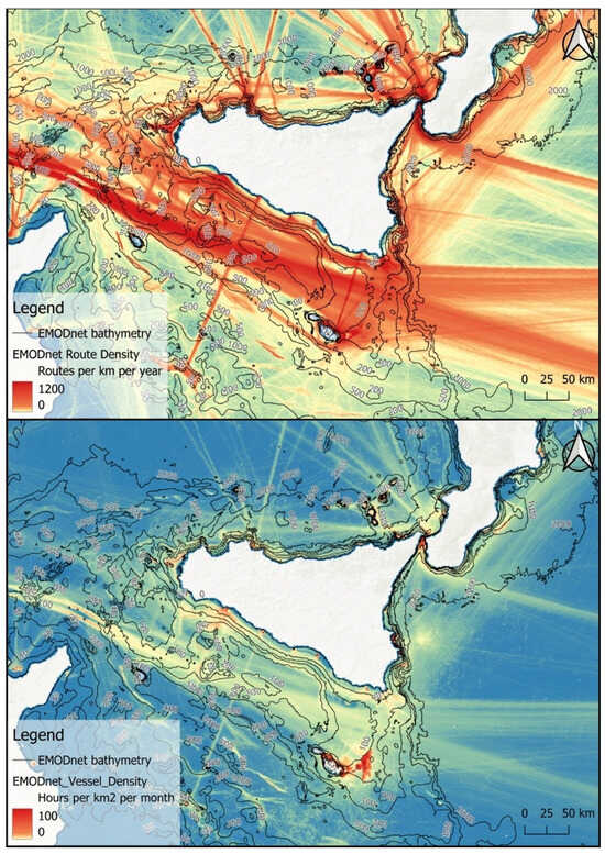
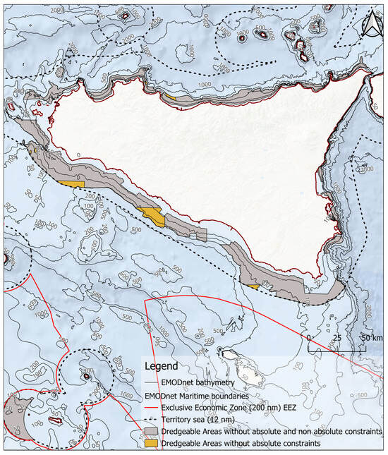
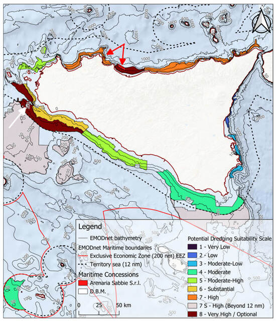
Sicily is a Mediterranean island region whose economy is based especially on tourism, with tourists being attracted to its beaches. The whole coastline of the island, including its minor islands, is 1745 km. At the moment, considering the whole period analyzed by the Coastal Plan of Sicilian Region (2008–2024), about 115 km of the 683 km of the main island’s sandy coastline present erosion problems that affect 23% of its unprotected coastline (506 km). Some of these problems are threatening Sicily’s economic and important historical assets as well as its cultural heritage; 177 km of protected beaches, using hard structure, have lost their original beauty. In the last fifty years, about 2.5 km2 of beaches were lost due to erosion, causing damages worth approximately 5 billion Euros. Current coastal management guidelines identify artificial beach nourishment as the most sustainable strategy for protecting the insular economy against the accelerating impacts of climate change. Successful nourishment, however, hinges on the availability of vast quantities of borrow material that must be granulometrically, compositionally, and chromatically compatible with native beach sediments. While subaerial quarries are being phased out due to their irreversible environmental degradation and logistical inefficiency, as well as local “ephemeral” sources (such as harbor dredging or over-alluvial deposits) providing insufficient volumes, the research has shifted toward Remote/Relict Marine Sediment Deposits (RMSDs). This study evaluates the strategic potential of RMSDs as a high-volume, low-impact resource for coastal defense. By integrating the geological, morphological, and sedimentological characteristics of the Sicilian continental shelf within a GIS framework, we have delineated potential dredging sectors. These areas are bounded by the −30 m isobath (the lower limit of Posidonia oceanica meadows) and the −200 m isobath, which represents the current operational limit of Jumbo Trailer Suction Hopper Dredgers (TSHDs). A multi-criteria constraint analysis was performed, categorizing environmental and infrastructural overlaps into fatal flaws (prohibitive) and non-prohibitive constraints. This subtractive spatial analysis reveals that approximately 6500 km2 of the Sicilian shelf may be eligible for resource exploitation concessions, pending site-specific, high-resolution surveys.
Full article
(This article belongs to the Special Issue Recent Progress in Land Degradation Processes, Control and Restoration)
►▼
Show Figures

Figure 1
Journal Menu
► ▼ Journal Menu-
- Land Home
- Aims & Scope
- Editorial Board
- Reviewer Board
- Topical Advisory Panel
- Early Career Editorial Board
- Instructions for Authors
- Special Issues
- Topics
- Sections & Collections
- Article Processing Charge
- Indexing & Archiving
- Editor’s Choice Articles
- Most Cited & Viewed
- Journal Statistics
- Journal History
- Journal Awards
- Society Collaborations
- Conferences
- Editorial Office
Journal Browser
► ▼ Journal BrowserHighly Accessed Articles
Latest Books
E-Mail Alert
News
Topics
Topic in
Businesses, Economies, Humanities, Land, Sustainability, Tourism and Hospitality, Urban Science
Human–Environmental Relations: Ecotourism and Sustainability
Topic Editors: Tamara Gajić, Minja Bolesnikov, Aleksandar ErcegDeadline: 15 July 2026
Topic in
Forests, Land, Remote Sensing, Urban Science
Remote Sensing of Urban Forests and Their Ecological Functions
Topic Editors: Zhibin Ren, Sheng Xu, Mingming Jia, Chunlin LiDeadline: 31 July 2026
Topic in
Agronomy, Drones, Geomatics, IJGI, Land, Remote Sensing
Advances in Multi-Scale Geographic Environmental Monitoring: Ecosystem Differences and Multi-Scale Comparisons
Topic Editors: Jingzhe Wang, Xiangyu Ge, Zipeng Zhang, Ivan Lizaga, Yinghui Zhang, Yangyi WuDeadline: 31 August 2026
Topic in
Agronomy, Climate, Crops, Grasses, Horticulturae, Land, Plants
Reframing Strategies for a Low Carbon Future in Agricultural Systems
Topic Editors: M. Ibrahim Khalil, Bruce OsborneDeadline: 8 October 2026
Conferences
Special Issues
Special Issue in
Land
Spatial Optimization of Land Use: A Perspective on Carbon Emission and Energy Landscape Planning
Guest Editors: Jing Huang, Wenjing Han, Chai Duo, Jing Lan, Shan GuoDeadline: 15 July 2026
Special Issue in
Land
Celebrating National Land Day of China
Guest Editors: Yurui Li, Fangzhou Xia, Hualin XieDeadline: 15 July 2026
Special Issue in
Land
Climate and Carbon Cycle Impact Assessment of Land Policies, Prospects and Challenges
Guest Editors: Jian Zhang, Xin Li, Hossein AzadiDeadline: 15 July 2026
Special Issue in
Land
Feature Papers for "Land Innovations—Data and Machine Learning" Section: 3rd Edition
Guest Editor: Chuanrong ZhangDeadline: 15 July 2026
Topical Collections
Topical Collection in
Land
Land Use Transitions and Land System Science
Collection Editor: Hualou Long
Topical Collection in
Land
Collection for the International Association for Landscape Ecology (IALE)
Collection Editor: Weiqi Zhou