Article

Resilience Assessment, Type Identification and Spatial Zoning of Traditional Villages from a Tripartite Attribute Perspective: A Case Study of Jincheng City, Shanxi Province, China


by
Xue Wang
1,2,* and
Kai Cui
1
1
College of Architecture and Art, Taiyuan University of Technology, Taiyuan 030024, China
2
Postdoctoral Research Center, Shanxi Construction Investment Group Co., Ltd., Taiyuan 030032, China
*
Author to whom correspondence should be addressed.
Land 2026, 15(7), 1229; https://doi.org/10.3390/land15071229 (registering DOI)
Submission received: 10 June 2026 / Revised: 6 July 2026 / Accepted: 6 July 2026 / Published: 8 July 2026

Abstract

Rapid urbanization and the urban-rural dualism are subjecting traditional villages to various slow-onset disturbances. The resilience of traditional villages (RTV) has become essential for their sustainable development. By measuring, classifying, and zoning RTV, this study aims to reveal its actual state and heterogeneous characteristics, thereby offering clear guidance for differentiated sustainable development strategies in traditional villages. From an integrated perspective of the tripartite attributes of traditional villages, this study develops an RTV assessment framework comprising three dimensions: structural persistability (SP) as vernacular heritage, functional adaptability (FA) as rural communities, and industrial transformability (IT) as tourism resources. Using hierarchical clustering, the obstacle degree model, the optimal parameters-based geographical detector, and spatially weighted hierarchical clustering, this study identifies distinct RTV types, along with their statistical distributions, key constraints, and spatial patterns. The main conclusions are as follows. (1) Most traditional villages in Jincheng exhibit low or medium-low levels of resilience. Moreover, the three dimensions of RTV are unevenly developed, with the IT dimension lagging markedly behind the others. (2) The key obstacles to enhancing RTV are the scarcity of high-value heritage resources, insufficient public services, low regional socioeconomic vitality, low public visibility, a scarcity of high-quality tourism assets, inadequate tourism support facilities, and a limited local tourism supply market. (3) Jincheng’s traditional villages cluster into four resilience-based zones, enabling a regional approach to their conservation.

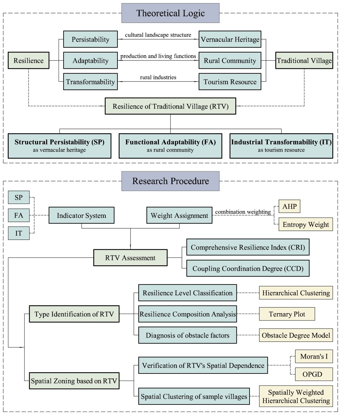
Graphical Abstract

1. Introduction

The resilience of traditional villages (RTV) can be conceptualized as the capacity of their territorial systems to resist and adapt to disturbances, maintain normal functioning, and reinvigorate development dynamics through self-adjustment [1,2]. Amid contemporary industrialization, urbanization, marketization, and informatization, the imbalance between urban and rural development is subjecting traditional villages to profound restructuring [3]. Responding effectively to these pressures is thus crucial, as it shapes both the conservation of cultural diversity and the outcome of rural revitalization efforts. Therefore, enhancing resilience is indispensable for achieving the sustainable development of traditional villages.
The concept of RTV stems from the broader discourse on rural resilience. As a critical issue for sustainable development worldwide, rural resilience has been examined from diverse perspectives, across multiple scales, and in varied geographical settings. As a theoretical tool, resilience theory has been applied to a wide range of rural issues, including rural human settlements [2], rural poverty [4], population hollowing [5], disaster response [6], land conservation [7], household livelihoods [8], and tourism development [9]. These studies confirm both the versatility of resilience theory and the complexity of rural resilience. However, in current rural resilience studies, the importance of culture-related issues remains significantly underestimated. Consequently, resilience research focusing specifically on traditional villages—a distinct settlement type characterized by its cultural significance—has drawn very limited scholarly attention. Moreover, existing RTV studies largely adhere to frameworks derived from general rural resilience research, often disaggregating RTV into economic, social, cultural, and ecological dimensions [1,10,11,12,13,14]. Traditional villages are not merely rural communities; they also embody scarce vernacular heritage and tourism resources. These multifaceted attributes render them particularly vulnerable to modernization and intensify the inherent tension between conservation and development. Due to that, existing frameworks for analyzing rural resilience fall short of capturing the specific characteristics of traditional villages. Furthermore, existing RTV research has largely adopted a disaster-response perspective [6,15,16,17,18]. However, the primary threats to the sustainable development of traditional villages today are not the physical destruction or social upheaval caused by sudden catastrophes—such as natural disasters, climate change, or pandemics—but the slow-onset, everyday disturbances, including the gradual transformation of cultural landscapes, economic decline, and persistent population loss [19]. With regard to research scale, most existing RTV studies have focused on a limited number of representative cases [1,11,13,14,16,20,21]. This study, therefore, adopts a broader spatial scale to examine the distribution pattern and spatial zoning of RTV, providing a scientific basis for implementing the policy of Centralized Contiguous Protection and Utilization of Traditional Villages (CCPUTV) [22]1.
In summary, existing RTV research has three main limitations. First, assessment systems are largely derived from generic rural resilience frameworks and are therefore not well-suited to capturing the particularities of traditional villages. Second, understandings of resilience have focused predominantly on responses to sudden-onset disasters. Third, large-scale regional research remains relatively scarce. To address these limitations, this study advances the application of rural resilience theory in traditional village research in three key respects. First, it develops an improved RTV measurement model to capture the comprehensive resilience of traditional villages amid the intertwined challenges of heritage conservation, community development, and economic transformation. Using this model, it also uncovers the differentiated development characteristics and latent tensions among these agendas. Second, it enriches the theoretical meaning of RTV by focusing on the context of everyday, slow-onset disturbances. Third, city-level regional research reveals the aggregate characteristics and spatial distribution patterns of RTV. By identifying distinct RTV types, along with their statistical distributions, key constraints, and spatial patterns, this study provides targeted guidance for sustainable development strategies in traditional villages.

2. Theoretical Framework

2.1. Resilience and Sustainable Rural Development

The term “resilience” originally denoted a system’s capacity to return to equilibrium or stability after being disturbed. In 1973, Holling introduced the concept from engineering into ecology [23], and later distinguished ecological resilience from engineering resilience by emphasizing characteristics related to system evolution [24]. Subsequently, the concept expanded from natural ecosystems to socio-ecological systems, in which humans and nature interact [2,25,26,27]. Social–ecological resilience has since become a central theme in research on sustainable human development. In this process, the understanding of resilience has shifted from a static, linear, and reactive perspective to a dynamic, nonlinear, and evolutionary one—a transition often characterized as moving from “bouncing back” to “bouncing forward”, where the latter denotes the long-term capacity to develop new growth paths through adaptation and transformation [28,29]. This notion of evolutionary resilience has thus emerged as a key theoretical framework for analyzing how urban and rural environments respond to complicating, long-term, and often imperceptible disturbances through gradual, discontinuous, and self-organizing processes.
Compared to well-established urban systems, rural territorial systems are more vulnerable. Rural decline has thus emerged as a major global issue, as rural areas face numerous challenges arising from both external and internal risks—including youth outmigration, inadequate infrastructure, limited access to basic services, declining agricultural productivity, and environmental degradation [2,5,7,30]. As a transition economy, China is witnessing unprecedented transformations in its rural areas. The future prospects of these regions are, however, a subject of theoretical uncertainty. One pessimistic perspective holds that rural areas are ultimately destined for structural decline and complete absorption into the urban system, a view exemplified by Friedmann’s core-periphery model [31] and Miller’s structural interpretation of rural population loss [32]. In contrast, a growing number of scholars have firmly rejected such determinism, arguing instead that rural areas can achieve sustainable revitalization by activating endogenous forces and pursuing multifunctional transformation, as reflected in the neo-endogenous development theory [33] and the rural resilience framework [34]. Whether rural areas ultimately follow a trajectory of decline or regeneration amid modernization hinges on the resilience of their territorial systems in an environment of rapid urban-rural resource flows [35]. Research on rural resilience has thus garnered increasing attention, with studies confirming its critical role in the sustainability of rural economies, societies, ecosystems, and cultures [4,8,36,37,38]. Among these, disaster-related resilience remains the dominant focus of academic inquiry [39,40,41]. This body of research rests primarily on the concept of engineering resilience, which emphasizes a system’s return to its previous stable state. However, slow-onset and less-traumatic disturbances are now driving socioeconomic and cultural changes in rural areas [19,30]. This ongoing “slow-burn” process constitutes the principal manifestation of rural decline and restructuring, underscoring the need for greater academic attention to the evolutionary resilience of rural areas under slow-onset disturbances [29]. This is especially true for traditional villages, where cultural and anthropological distinctiveness constitutes the core value, and where the systemic damage wrought by slow-onset disturbances is often fundamental and irreversible.
Traditional villages encounter not only the challenges common to rural areas [42,43] but also face more stringent and complex choices regarding their development pathways. The central question in their revitalization is how to harness historical and cultural resources. Yet underpinning this question are numerous inherent tensions—tradition versus modernity, the local versus the external, and short-term interests versus long-term heritage value. In recent years, research on traditional villages has undergone a notable shift: in perspective, from focusing on material composition toward essential driving factors [44]; and in methodology, from qualitative approaches such as simple spatial overlay analysis and descriptive statistical analysis toward mechanistic studies employing mathematical models [45,46]. However, persistent binary thinking that frames conservation and development as opposing forces has left conservation approaches often divorced from lived realities, fueling intractable conflicts among multiple stakeholders [47]. A comprehensive analytical framework that integrates the conservation and development of traditional villages into a unified system is therefore imperative.

2.2. Improved Conceptual Framework for RTV Integrating the Tripartite Attributes of Traditional Villages

2.2.1. Tripartite Attributes of Traditional Villages in the Contemporary Context

Traditional villages integrate three distinct attributes—vernacular heritage, rural communities, and tourism resources—that collectively shape their path toward sustainable development [48].
The conservation of vernacular heritage is essential for sustaining place identity and cultural diversity. Psychological research indicates that perceived cultural continuity is significantly associated with psychological distress [49]. Place identity is a fundamental mental need, and vernacular heritage enables its embodiment. Moreover, vernacular heritage constitutes an essential component of cultural diversity, a common heritage of humanity that serves as an indispensable pillar of sustainable development [50].
Rural community development is central to the well-being of rural residents and a necessary step toward bridging the urban-rural dualism. Since 2017, China has been implementing the Rural Revitalization Strategy, which aims to balance public resource allocation between urban and rural areas, expand economic opportunities in the countryside, and raise farmers’ incomes [19,51]. Tackling these issues is fundamental to maintaining social harmony and achieving common prosperity.
Rural tourism offers a vital pathway for the sustainable development of traditional villages. The decline of traditional villages is rooted in the gradual loss of the economic relevance of their original productive functions in the contemporary era [42]. Rural tourism can activate the endogenous development dynamics of traditional villages, revitalize rural industries, and reshape urban-rural relations, a role that has been widely recognized in international scholarship [9,52,53].

2.2.2. Improved Conceptual Framework for RTV

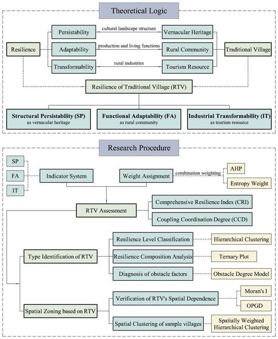
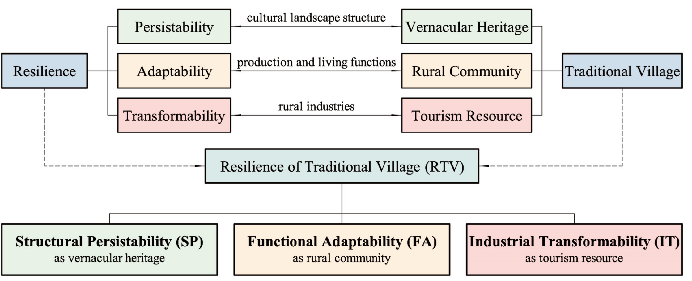
The three theoretical principles of “resilience” broadly recognized are persistability, adaptability, and transformability [54,55,56]. Persistability means that the system can withstand perturbations and still persist. Adaptability means that the system can respond to environmental changes through constant self-adjustment. Transformability means that the system can explore new development patterns through renewal and reform. To achieve sustainable development, traditional villages must possess all three dimensions of resilience.
Drawing on Li’s (2013) theory of the three attributes of traditional villages [48] and incorporating the three resilience dimensions of persistence, adaptability, and transformability proposed by Folke et al. (2010) [55] and Keck & Sakdapolrak (2013) [54], this study establishes the following RTV theoretical framework (Figure 1). This framework embeds RTV research within three contemporary core agendas for traditional villages—heritage conservation, community development, and economic transformation—thereby establishing clear theoretical connections. Within this framework, the sustainable development of traditional villages can be further deconstructed into three capacities. (1) As vernacular heritage, traditional villages must maintain the structural persistence of their cultural landscape amid the pressures of urbanization and industrialization, so that their cultural significance remains undiminished. (2) As rural communities, traditional villages must continuously enhance their functions to meet the growing productive and living needs of residents, thereby achieving a high standard of livability. (3) As tourism resources, traditional villages must be utilized scientifically to revitalize productive capacity through industrial transformation. In summary, RTV can be conceptualized as comprising three dimensions: structural persistability (SP) in the attribute as vernacular heritage, functional adaptability (FA) in the attribute as rural community, and industrial transformability (IT) in the attribute as tourism resource.
The framework is designed to address the following questions: (1) How can resilience measurement capture the overall performance of traditional villages amid their threefold development agendas? (2) How do traditional villages differ in their resilience across the three dimensions? (3) Does RTV exhibit spatial dependence, and if so, what spatial clusters emerge? (4) What development strategies should be pursued to enhance RTV?

3. Materials and Methods

3.1. Study Area

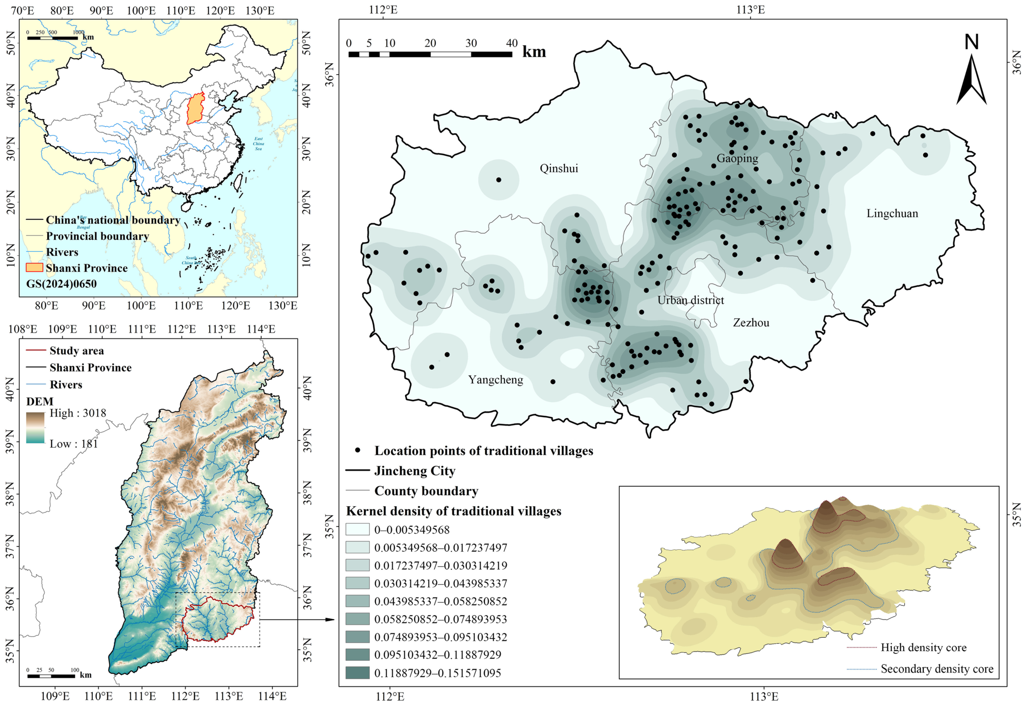
Jincheng is a prefecture-level city in southeastern Shanxi Province, China. As a cradle of Chinese civilization, it boasts a rich cultural heritage. With a forest coverage rate of 40.3%, it also features an exceptional natural environment. In 2021, it was designated a Model City for Healthy Ageing by the International Institute on Ageing, United Nations—Malta (INIA). Jincheng was selected as the study area primarily because it has the greatest number and highest density of traditional villages in Shanxi Province, making it the province’s only national demonstration city for CCPUTV. According to the first to sixth batches of the List of Chinese Traditional Villages released by the Ministry of Housing and Urban-Rural Development, Jincheng is home to 186 traditional villages, which serve as the analytical sample for this study (Figure 2).

3.2. Data Sources and Preprocessing

The dataset used in this study combines data from various sources and of multiple types (Table 1). To maintain temporal consistency, dynamic socioeconomic and land-use data are drawn from 2023 as single-year observations2, while data covering the most recent five-year period spans from 2018 to 2023.
The assessment indicators used in this study differ in their numerical ranges, units, and directions. To resolve these discrepancies, the min-max normalization method was applied [2,17,25]. After normalization, all indicator values were mapped to [0, 1] to facilitate linear weighted aggregation. The calculation formulas are as follows:
R i j   =   X i j X m i n X m a x X m i n   ( positive   indicators )
R i j = X m a x X i j X m a x X m i n   ( negative   indicators )
where Rij denotes the normalized indicator value for the ith village under the jth indicator, Xij denotes the raw indicator value, and Xmin and Xmax denote, respectively, the minimum and maximum values of a given indicator (the same hereinafter).

3.3. Research Design

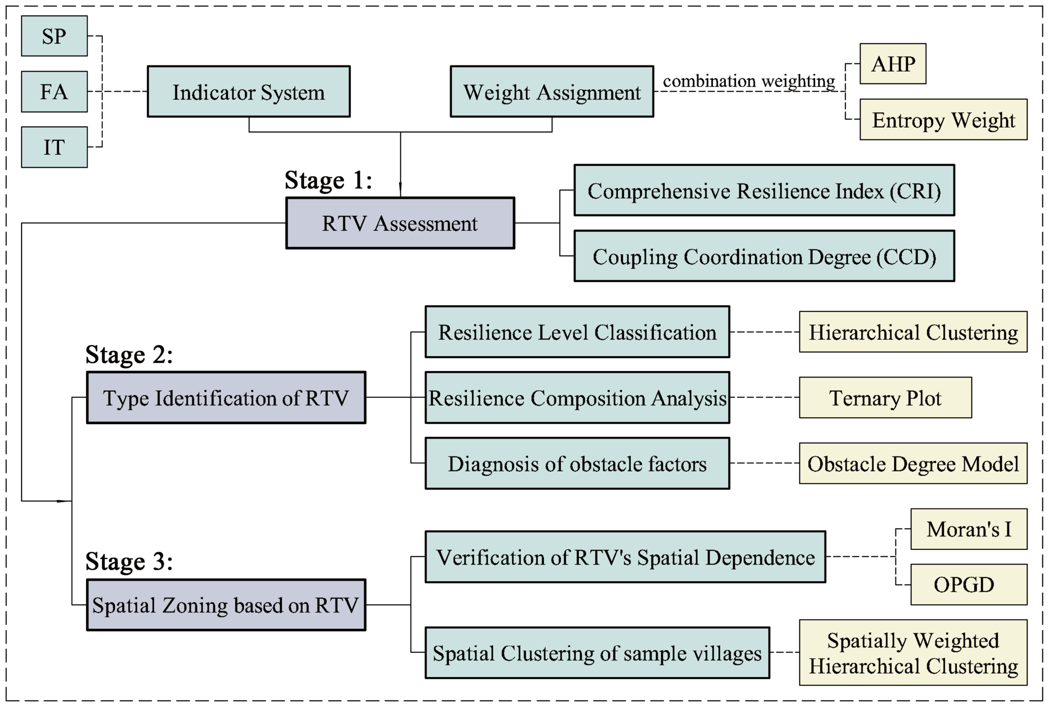
This study establishes a research framework for RTV following a “measurement system construction—type identification—spatial zoning” logic (Figure 3). The framework consists of three stages.
Stage 1 constructs a three-dimensional measurement model for RTV, comprising three steps: the construction of the indicator system, weight assignment, and a comprehensive assessment. Weights are assigned using a combined subjective-objective weighting method that integrates the Analytic Hierarchy Process (AHP) and the entropy weight method. Two composite indicators—the comprehensive resilience index (CRI) and the coupling coordination degree (CCD)—are used to measure the overall RTV level.
Stage 2 involves RTV type identification and characterization, encompassing three steps: classifying overall RTV levels, identifying ternary composition types, and comparing type-specific characteristics. Hierarchical clustering is used to classify overall RTV levels, while types defined by the three-dimensional composition of RTV are identified and visualized through a ternary plot. The obstacle degree model is then employed to identify the key obstacle factors for RTV and to examine how these factors perform differently across RTV types.
Stage 3 focuses on spatial zoning of traditional villages based on RTV, including two steps: verifying spatial dependence and performing spatial clustering. Spatial dependence is first examined using Global Moran’s I to preliminarily assess the spatial clustering pattern of RTV, and the optimal parameters-based geographical detector (OPGD) is subsequently employed to explore the geographical drivers of its spatial heterogeneity. Spatial clustering of the traditional villages is conducted using a spatially weighted hierarchical clustering algorithm that integrates both RTV and spatial locations into the clustering decision.

3.4. Measurement Method of RTV

3.4.1. Construction of the Indicator System for RTV Assessment

To ensure that the indicators comprehensively, objectively, and precisely reflect the characteristics of RTV, this study developed a rigorous indicator-construction process, as detailed below.
(1) Establishment of the assessment dimensions: The assessment dimensions—SP, FA, and IT—were drawn from the theoretical framework presented above (Figure 1), and serve as the criterion layer of the assessment framework. SP encompasses the built fabric and the landscape setting, which together form the structure of cultural landscapes. FA encompasses community functions such as agricultural production, modern life services, and socioeconomic vitality. IT involves key factors in tourism development, including resource endowments, locational conditions, organizational capacity, and supporting services.
(2) Preliminary selection of candidate indicators: Candidate indicators were drawn from three sources, including literature review, expert consultation, and field investigation. First, through a systematic review of the Web of Science and China Knowledge Network (CNKI) databases, assessment indicators used in existing studies on traditional villages [1,10,12,14,46] and rural resilience [2,25,37,57,58,59,60] were screened and categorized. Second, the authors consulted specialists with extensive experience in both the theoretical research and practice of traditional village conservation. Third, based on fieldwork conducted in a representative sample of traditional villages in Jincheng during August 2025, the key factors influencing their sustainable development were recognized.
(3) Confirmation of assessment indicators: The final selection of candidate indicators was based on two criteria: indicator redundancy and data availability. First, indicators with inaccessible data at the current stage were removed, and data were then collected for the remaining indicators. Next, using Spearman correlation analysis, indicator pairs with correlation coefficients exceeding 0.9 were selected for pairwise comparison. Finally, indicators were retained based on their logical interpretability and numerical variability (measured by information entropy H; see Formula (5) in Section 3.4.2). This process resulted in an RTV assessment indicator system comprising 26 indicators (See Table 2; Detailed explanation and calculation methods are provided in Table A1 in Appendix A). The correlation coefficients for all indicators ranged from −0.820 to 0.894, and each indicator directly reflected the assessment’s purpose.

3.4.2. Determination of Indicator Weights

This study employs a combined subjective–objective weighting method to assign indicator weights. The AHP calculates subjective weights, which capture the intentions and expertise of decision-makers but are susceptible to personal bias. The entropy weight method calculates objective weights based on data variability to avoid subjectivity; however, it does not reflect the practical significance of the indicators. Therefore, the combined weighting method reduces the subjectivity of the weights while preserving their practical meaning. Combining the AHP with the entropy weight method has become a well-established approach for mitigating bias in weight assignment. It is widely applied in assessments of ecological environments, social-ecological systems, and other complex systems [1,61,62,63,64]. The detailed implementation of the AHP and the entropy weight method is presented in Zeng et al. (2022) [62]. In this study, the subjective and objective weights are integrated using the geometric mean method [64,65], which aggregates information from different sources in a relatively balanced manner, resulting in a more robust weight assignment. The formulas for calculating the combined weights are as follows:
AV = λ max V
W sub - j = V j j = 1 m V j
H j = 1 ln n i = 1 n P i j × ln P i j
P ij = R i j i = 1 n R i j
W o b j - j = 1 H j j = 1 m 1 H j
W = W s u b × W o b j
W j = W j j = 1 m W j
In the above formulas, A denotes the pairwise comparison matrix of indicator importance in the AHP method, λmax denotes the maximum eigenvalue of A, and V denotes the eigenvector corresponding to λmax. Hj denotes the information entropy of the jth indicator. Wsub and Wobj denote the subjective and objective weights, respectively. Wj denotes the combined weight of the jth indicator. n denotes the number of villages, and m denotes the number of indicators (the same hereinafter). When calculating Wsub, the consistency ratios of the importance judgment matrices for the three dimensions were 0.0153, 0.0134, and 0.0148, all below the 0.1 threshold, confirming that each matrix satisfied the consistency requirement.
Indicator-layer weights for each dimension were calculated as described above. Subsequently, the criterion-layer weights for the three dimensions were each set to 1/3. The rationale for assigning equal criterion-layer weights to the three dimensions is twofold. First, from a theoretical perspective, all three dimensions are considered equally important to the system’s overall resilience. Assigning a higher weight to any single dimension may therefore undermine the intended objective of the assessment. Second, indicator weights were normalized within each criterion layer rather than globally, to prevent the number of indicators from distorting the criterion-layer weights. This also ensures that the composite scores across the three dimensions are comparable, thereby reflecting genuine differences in developmental levels rather than differences in weights. Equal criterion-layer weights also facilitate subsequent inter-dimensional analyses. This weighting approach has been widely adopted in previous studies [2,25], thereby confirming its validity. The results of the weight assignment are presented in Table 2.

3.4.3. Comprehensive Resilience Index (CRI)

CRI was calculated using the linear weighted method. Dimension scores were first calculated within each criterion layer and then aggregated to derive the overall CRI, as follows:
Dim _ k   =   j = 1 m W j × R i j   ( k   =   1 ,   2 ,   3 )
C R I   =   ( S P + F A + I T ) / 3
where Dim_k denotes the three dimensions—SP, FA, and IT.

3.4.4. Coupling Coordination Degree (CCD)

The CCD model is a well-established analytical tool for measuring coordinated development among multiple subsystems within a complex system [66]. CCD for the three dimensions was calculated as follows:
C   =   3 S P × F A × I T 3 S P + F A + I T
CCD = C × C R I

3.5. RTV Type Identification and Characterization

3.5.1. RTV Levels Classified Using Hierarchical Clustering

RTV levels were classified using both CRI and CCD by applying hierarchical clustering to the [CRI, CCD] matrix. Hierarchical clustering is an unsupervised learning algorithm that constructs clusters in a bottom-up, agglomerative manner by iteratively merging the two closest clusters at each step. It is not only the most widely used clustering approach but has also been demonstrated to outperform other algorithms, such as K-means clustering and self-organizing maps (SOM) [67]. This method is well-suited to this study for several reasons. First, it does not require a prespecified number of clusters, making it ideal for exploratory data analysis. Second, it can accommodate any distance metric, flexibly handling multidimensional indicators without assuming a spherical data distribution. This characteristic aligns well with the multidimensional and heterogeneous nature of the RTV indicator system. Finally, unlike K-means, the clustering result is uniquely determined by the data and the chosen linkage method, rather than relying on random initial centers, thereby ensuring the stability of the RTV-level classification. In this study, Ward’s method was employed as the linkage strategy, which minimizes within-cluster variance at each merger. Finally, clustering quality was assessed using the average silhouette coefficient, and RTV levels were identified based on the rank order of the cluster centers.

3.5.2. Composition Analysis of RTV

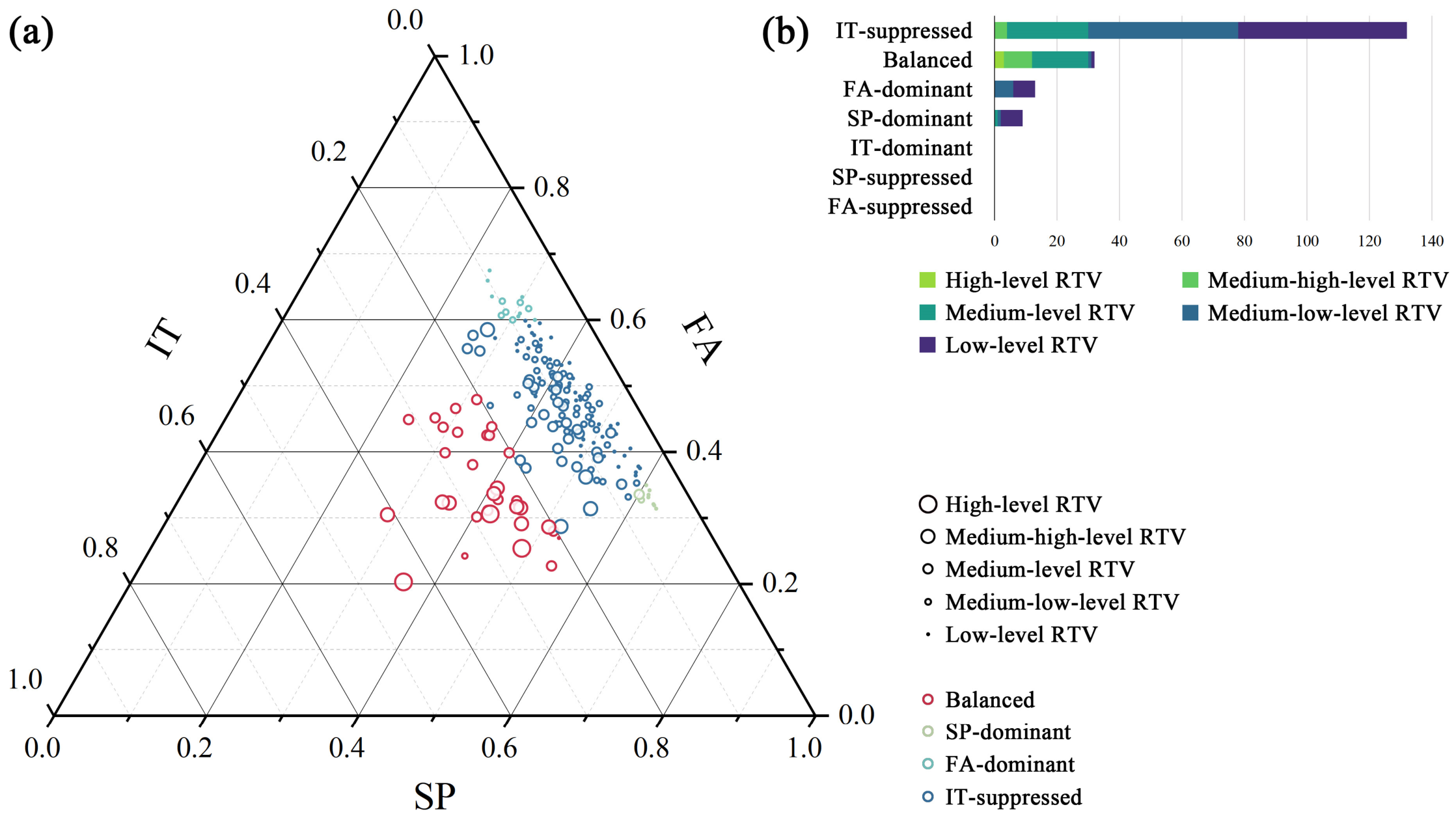
While RTV levels represent the overall resilience assessment, the internal relationships among the three dimensions require further analysis through decomposing RTV. A ternary plot with SP, FA, and IT as axes was used to visualize the distribution of the three dimensions’ contribution rates to CRI. When a dimension accounts for 0.6 or more, it is identified as dominant. When a dimension accounts for 0.2 or less, with the other two each accounting for less than 0.6, it is identified as suppressed. When the contribution rates across all three dimensions fall within the range of 0.2 to 0.6, the compositional pattern is identified as balanced. This threshold-setting scheme was informed by two considerations. First, the empirical data distribution shows that this scheme avoids an excessive concentration of data points near the threshold boundaries. Second, the scheme is mathematically justified. A dominance threshold (T_dom) greater than 0.5 ensures that only one dimension is dominant, since this implies that its contribution exceeds the combined contributions of the other two, thereby fully reflecting its dominant role. The suppression threshold, defined as T_sup = (1 − T_dom)/2, guarantees that when no dimension is dominant, only one dimension can be classified as suppressed. In this study, T_dom and T_sup were therefore set to 0.6 and 0.2, respectively. This classification approach uniquely determines the type of each village.
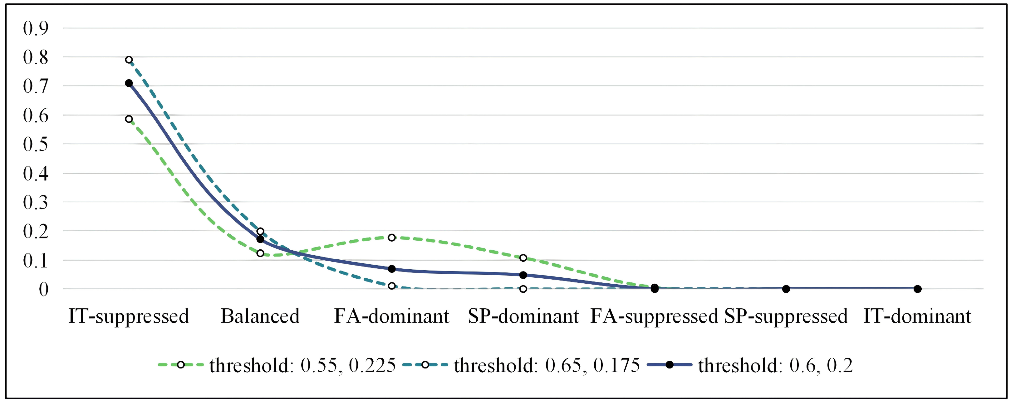
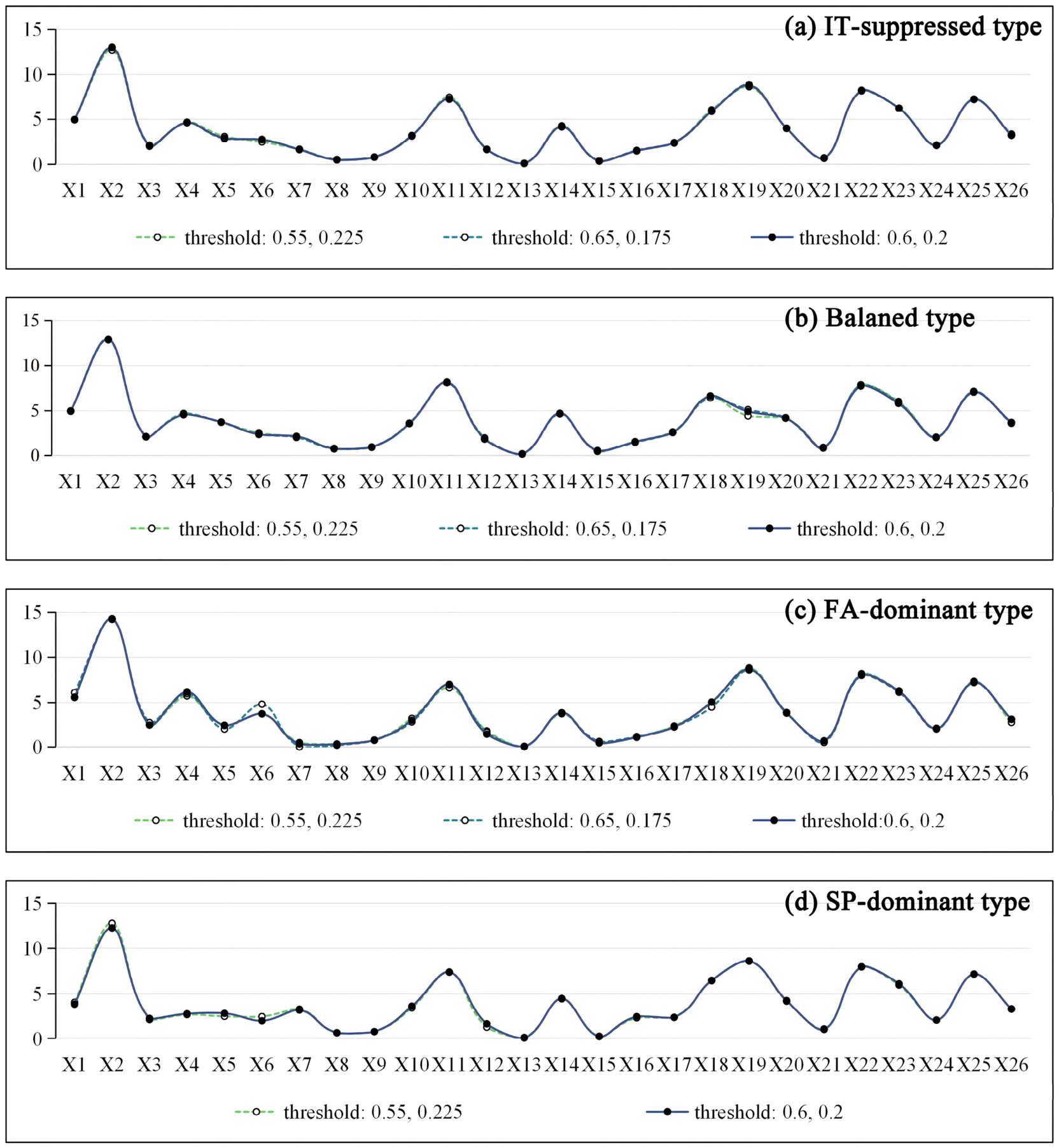
To further test the sensitivity of the RTV classification to threshold settings, two alternative parameter sets were introduced: T_dom = 0.65 with T_sup = 0.175, and T_dom = 0.55 with T_sup = 0.225. Comparing the distribution of RTV types across the three schemes showed that the statistical profile of each type remained largely stable, indicating that minor adjustments to the thresholds do not substantially alter the overall distribution pattern (see Figure A1 in Appendix B). Since the classification would subsequently underpin an obstacle degree analysis of different RTV types, obstacle degrees for each indicator were calculated under all three schemes. The resulting fluctuations were minimal across all indicators. With the exception of indicator X6, which displayed a maximum change of 1.07 in the FA-dominant type, the changes for all other indicators remained within ±0.5 (see Figure A2 in Appendix B). These results confirm the robustness of the chosen threshold scheme.

3.5.3. Identification of Key Obstacle Factors

The obstacle degree model was applied to identify key obstacles to enhancing RTV. The model is particularly effective at identifying the weakest link in a system and has been widely applied to attribution diagnostics following multi-indicator assessments [2,36,64]. RTV is a composite system comprising multiple interacting elements, and its overall level is typically determined by its most vulnerable components—a phenomenon often conceptualized as the “barrel effect”. By quantifying the constraining intensity of each indicator, the model accurately identifies the key obstacles to resilience, thereby providing clear guidance for targeted improvement strategies. The obstacle degree (O) is determined by both the factor contribution degree (F) and the index deviation degree (I). The calculation formulas are as follows:
F j = W i / 3
I i j = 1 R i j
O ij = F j × I i j j = 1 m F j × I i j   ×   100 %
where Wj represents the indicator-layer weight of the jth indicator, and m represents the number of indicators.

3.6. Spatial Clustering of Traditional Villages Based on RTV

3.6.1. Spatial Dependence of RTV

To assess the feasibility of spatial clustering based on RTV, global spatial autocorrelation analysis was first conducted on CRI and CCD to test for spatial dependence. The spatial clustering characteristics were assessed using Global Moran’s I, Z-score, and p-value.
To explore the mechanisms underlying the spatial dependence of RTV, this study further identifies the geographic factors that influence it. First, a set of geographic factors theoretically influencing the development of traditional villages is selected, including the kernel density of traditional villages (Y1), average slope (Y2), distance to water (i.e., the nearest permanent river or water body) (Y3), and road network density (Y4). The OPGD method is employed to assess the influence of these geographic factors on SP, FA, IT, CRI, and CCD. Since both the RTV indicators and the influencing factors are continuous variables, the conventional geographical detector often produces subjective results due to inconsistent discretization criteria. The OPGD method overcomes this limitation by automatically identifying the optimal discretization scheme—including both the method and the number of classes—that maximizes the explanatory power of each factor [68]. This provides a more objective measure of factor influence that better reflects the actual underlying processes. The explanatory power of each factor is measured by the q-value, and the direction of its influence is determined using Spearman correlation.

3.6.2. Zoning of Traditional Villages Using Spatially Weighted Hierarchical Clustering

This study sought to explore the spatial clustering of traditional villages based on their resilience characteristics. For this purpose, the spatially weighted hierarchical clustering method was applied. This method extends the standard hierarchical clustering algorithm by incorporating spatial weights, so that objects that are spatially proximate and similar in their attributes are more readily grouped together, which is consistent with the spatially clustered distribution of RTV. The clustering strategy was adopted based on two considerations. First, cluster-based conservation of traditional villages, guided by resilience characteristics, facilitates the exploration of differentiated, sustainability-oriented development pathways. Second, spatial proximity is a prerequisite for such cluster-based conservation, since spatial dispersion not only fragments cultural landscapes but also impedes resource sharing and coordinated development. The method constructs a spatially weighted distance (SWD) matrix as follows. A spatial distance (SD) matrix is constructed from the spatial coordinates, and an attribute distance (AD) matrix is constructed from the CRI and CCD values. The two matrices are then standardized and linearly combined, expressed as SWD = αSD + βAD (α + β = 1). In this study, spatial continuity was prioritized by assigning a slightly higher weight to SD, with α set to 0.6 and β to 0.4. The value of α was determined through a series of experiments in which it was iteratively adjusted within the range of 0.4 to 0.6. The results showed that when α fell below 0.6, the resulting clusters exhibited spatial fragmentation and overlap, undermining the practical meaning of the zoning scheme. At α = 0.6, the clusters still maintained an acceptable level of inter-cluster attribute differentiation. The value α = 0.6 was therefore selected as the minimum spatial weight that produces spatially contiguous, non-overlapping clusters while still preserving meaningful attribute cohesion.

4. Results

4.1. Identified RTV Types and Their Characteristics

4.1.1. RTV Levels and Their Distributions

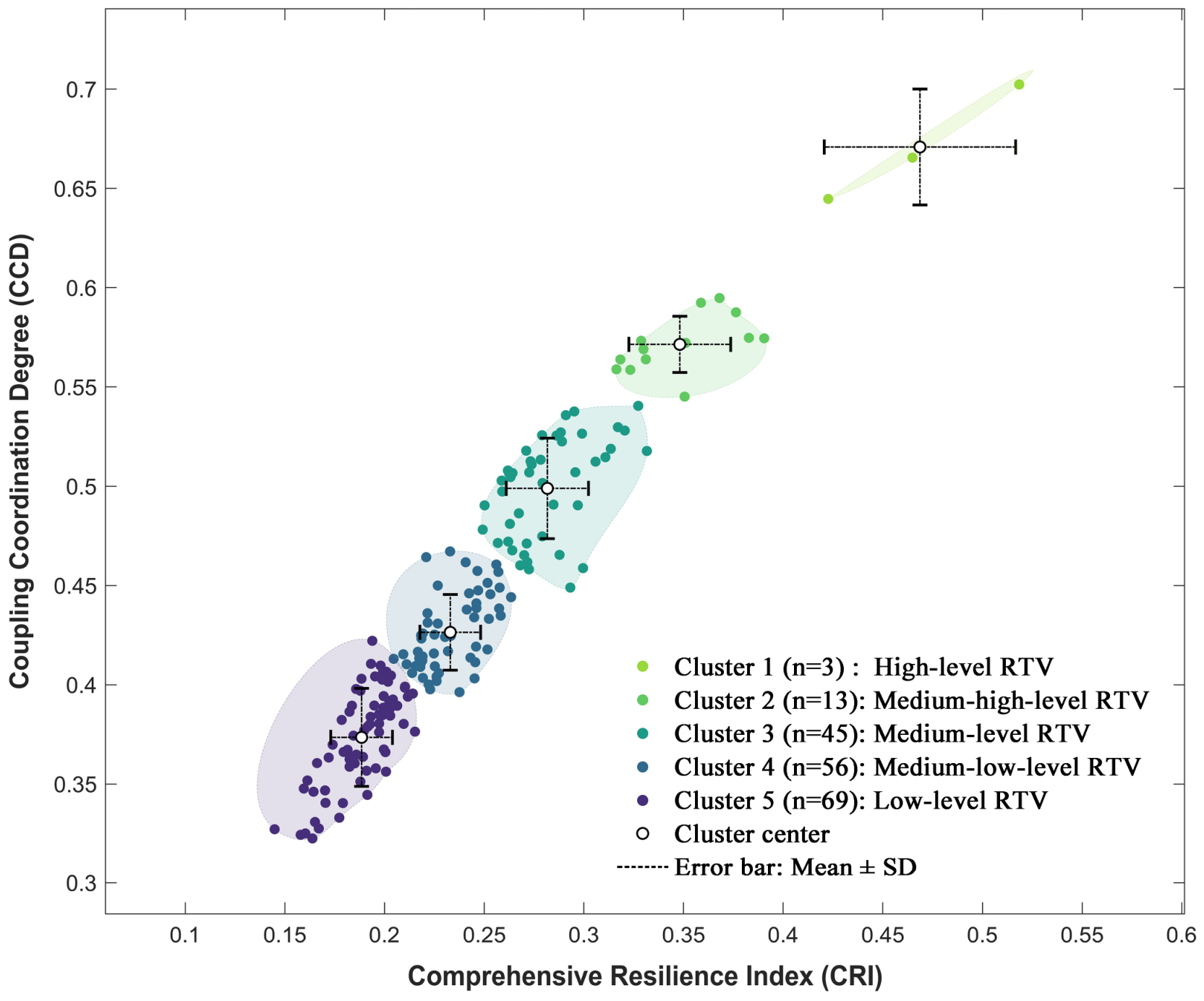
Using the hierarchical clustering algorithm, the [CRI, CCD] matrix data were grouped into five clusters (Figure 4). The average silhouette coefficient was 0.643 (>0.5), indicating robust clustering quality [36]. Based on the cluster centers, the 5 clusters were identified as high-level, medium-high-level, medium-level, medium-low-level, and low-level RTV. Among them, villages with high and medium-high resilience levels accounted for only 8.60% of the total; those with a medium resilience level accounted for 24.19%; and those with medium-low and low resilience levels accounted for 67.20%. This distribution indicates that most traditional villages in Jincheng currently need to improve their resilience, with only a few showing strong potential for sustainable development.

4.1.2. RTV Types Based on Compositional Features and Their Distributions

The ternary plot (Figure 5a) shows that the contribution rates of the three dimensions to comprehensive RTV are highly unevenly distributed, with an overall skew toward the side where the IT dimension is suppressed. The IT-suppressed type accounted for the majority of villages (70.97%), followed by the balanced type at 17.20% (Figure 5b). A small proportion were identified as FA-dominant (6.99%) and SP-dominant (4.84%). This distribution indicates that in most villages, the IT dimension remains underdeveloped, while agriculture continues to serve as the dominant industry. Notably, all villages with a relatively well-developed IT dimension were identified as the balanced type; none fell into the IT-dominant, SP-suppressed, or FA-suppressed types. This suggests that the IT dimension relies on the quality of the cultural landscape and community prosperity, both necessary conditions for rural tourism development in traditional villages. The balanced type mainly comprises villages with medium or higher resilience levels, including all high-resilience villages and most medium-high-resilience villages. In contrast, the IT-suppressed type primarily consists of villages with low and medium-low resilience levels. Overall, this pattern suggests that, at the dimension level, the primary constraint on RTV is the IT dimension.

4.1.3. Key Obstacles to Enhancing RTV

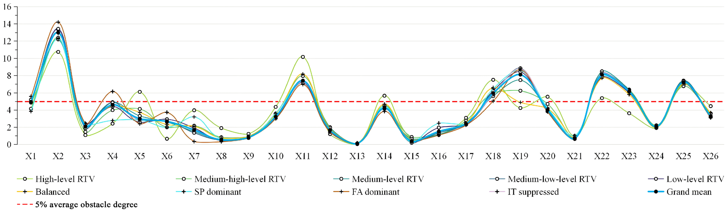
The obstacle degree analysis identified the key factors constraining RTV improvement at the indicator layer. Factors with an average obstacle degree exceeding 5%, in descending order, include (Figure 6): outstanding historical and cultural value (X2), online visibility (X22), abundance of tourism assets (X19), density of public service facilities (X11), number of restaurants and lodging facilities within the village (X25), locally based rural tourism enterprises (X23), and nighttime light intensity (X18).
Within the SP dimension, RTV is primarily constrained by the limited stock of historically and culturally significant heritage resources (X2). Additionally, X2 exhibits consistently high obstacle degrees across all types, peaking in the FA-dominant type. Within the FA dimension, the main constraints are an inadequate supply of public service facilities (X11) and insufficient regional prosperity and population concentration (X18). Moreover, the constraining effects of X11 and X18 are more pronounced in high-resilience villages than in other types. Within the IT dimension, the main constraints are insufficient public attention (X22), limited availability of high-quality tourism assets (X19), a shortage of restaurants and lodging facilities for visitors (X25), and a limited number of local rural tourism enterprises (X23). Only high-resilience villages receive relatively close public attention (X22). X19 displays a gradient across villages with different resilience levels; that is, villages with more abundant tourism assets tend to have higher resilience. Meanwhile, its obstacle degree remains consistently high in types with poor IT-dimension performance. The shortage of dining and accommodation facilities (X25) is a common issue across all types of villages. Except for high-resilience villages, all others currently exhibit limited tourism market supply (X23).
In addition, the obstacle degrees for several other indicators vary considerably across village types: high-resilience villages exhibit greater obstacle degrees for X5, X14, and X20; FA-dominant villages exhibit greater obstacle degrees for X1 and X4.

4.2. Conservation Zoning of Traditional Villages by RTV Cluster Differentiation

4.2.1. Spatial Clustering Characteristics of RTV

The global spatial autocorrelation analysis revealed statistically significant positive spatial autocorrelation in both CRI and CCD. For CRI, Moran’s I was 0.318 (Z-score = 16.035, p < 0.001). For CCD, Moran’s I was 0.303 (Z-score = 15.188, p < 0.001). These results indicate that RTV exhibits significant spatial clustering, supporting the feasibility of zoning traditional villages by their resilience characteristics.
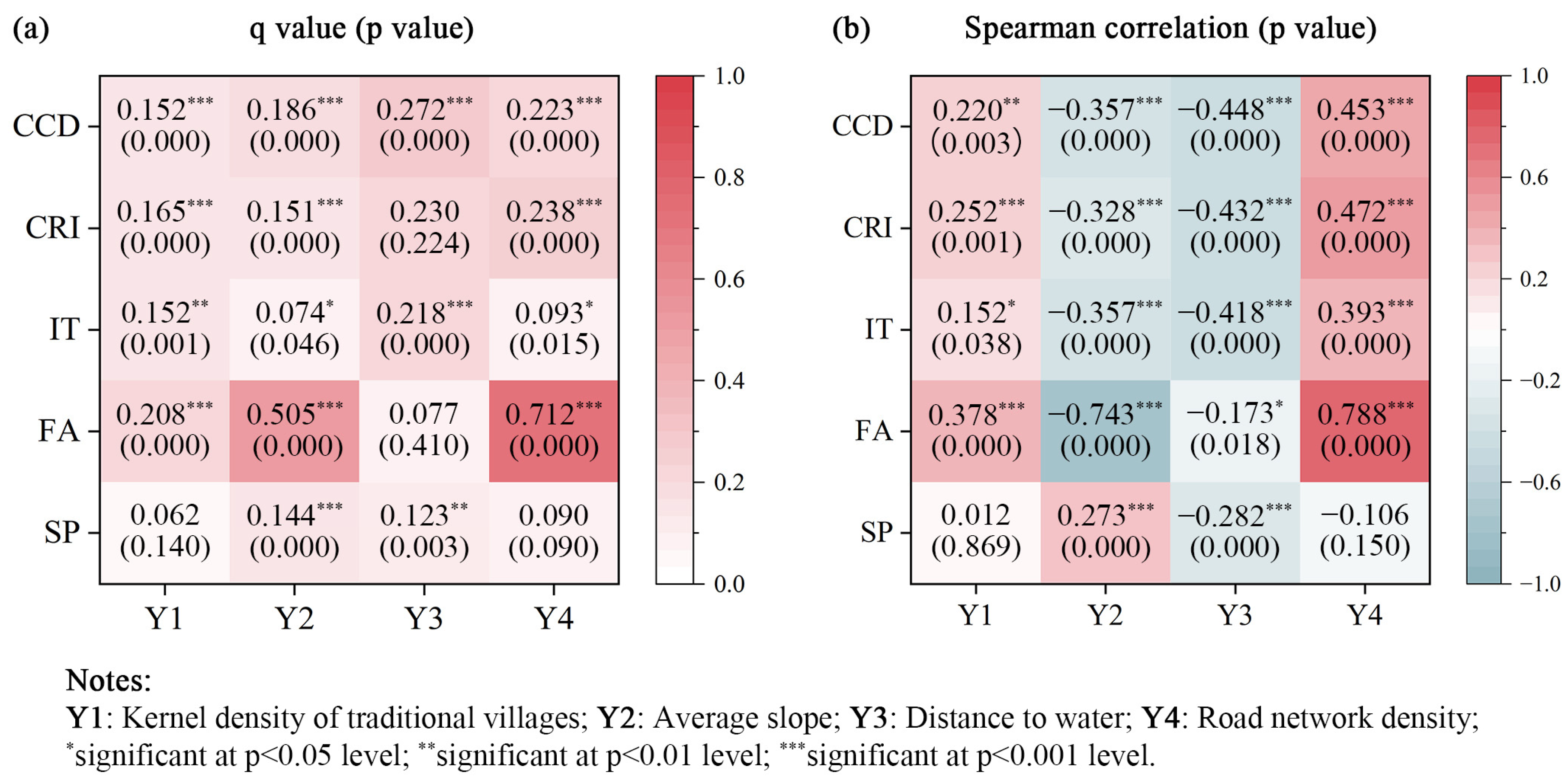
The OPGD and Spearman correlation analysis revealed that kernel density of traditional villages (Y1), average slope (Y2), and road network density (Y4) each explained a statistically significant portion of the spatial variation in both CRI and CCD. Among these factors, Y1 and Y4 had a positive effect, while Y2 had a negative effect (Figure 7). These findings indicate that RTV tends to be higher in areas characterized by a higher concentration of traditional villages, gentler terrain, or denser road networks. For the three dimensions separately, SP was influenced positively by Y2 and negatively by Y3; FA was influenced by the positive effects of Y1 and Y4 and the negative effects of Y2, with Y2 and Y4 demonstrating strong explanatory power; IT was mainly influenced positively by Y1 and negatively by Y3 (Figure 7). These findings suggest that in areas with clustered traditional villages, gentle terrain, or high road network density, community production and living functions are more developed. In areas with rugged terrain, community development is constrained, which in turn favors the conservation of cultural landscapes. Areas near water typically boast attractive landscapes and ecosystems, which enhance their tourism appeal. Furthermore, rural tourism tends to develop in regional clusters.

4.2.2. RTV-Based Traditional Village Zoning

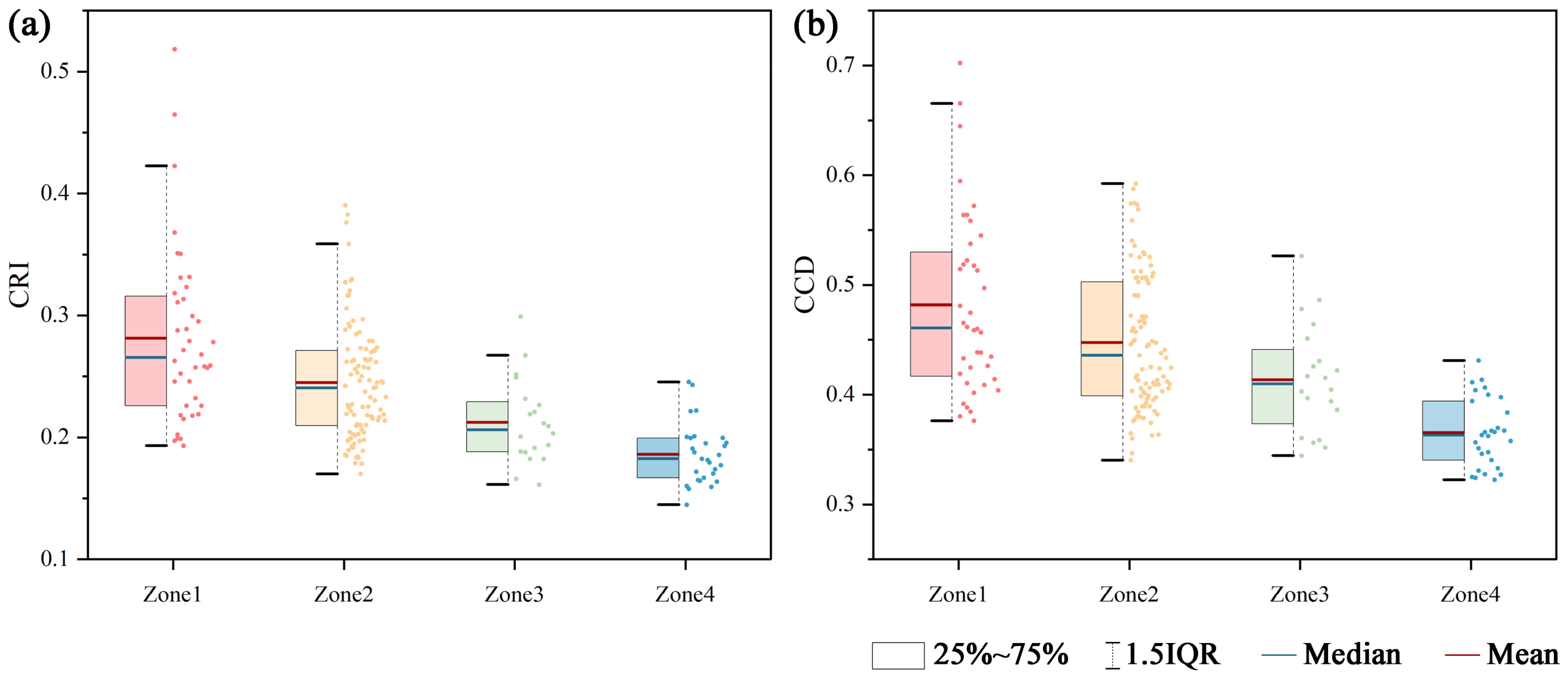
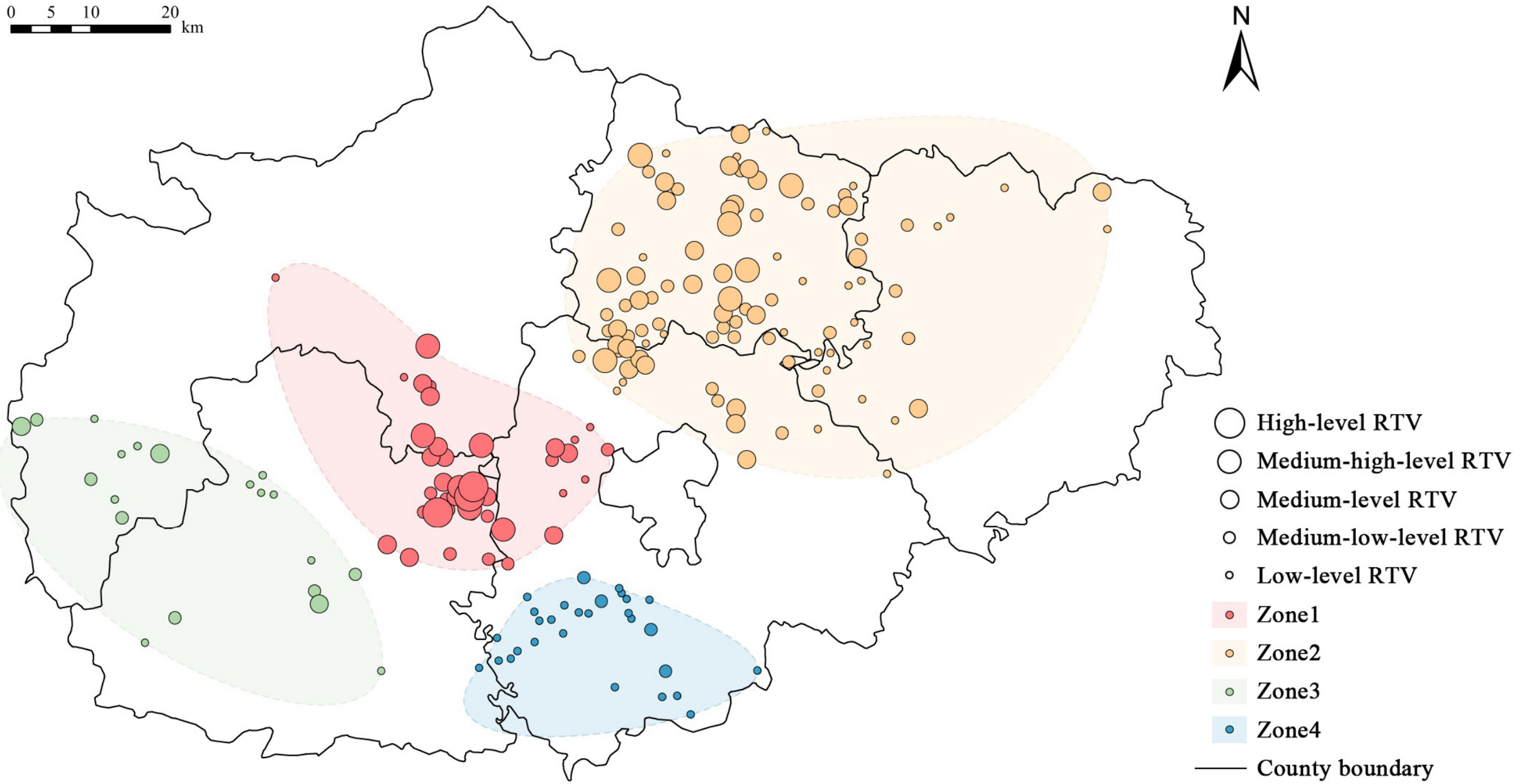
Through the spatially weighted hierarchical clustering, the traditional villages in Jincheng were classified into four zones. The average silhouette coefficient was 0.402 (within the 0.2–0.5 range), indicating acceptable clustering quality despite some overlap between clusters [36]. The spatial distribution of the four zones is shown in Figure 8. A Kruskal–Wallis test based on this zoning scheme revealed that both CRI and CCD varied significantly across the four zones (p < 0.001), indicating distinct resilience levels among them.
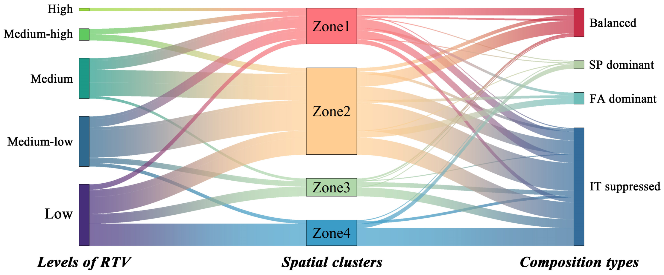
As shown in Figure 9, the average values of RTV across the zones rank as follows: Zone 1 > Zone 2 > Zone 3 > Zone 4. Figure 9 and Figure 10 together illustrate the characteristics of the four zones. Zone 1 has the highest average RTV and the greatest internal variation. It contains all high-resilience villages and approximately half of the medium-high-resilience villages. Zone 2 has the largest number of villages and the widest spatial extent, with an average RTV second only to Zone 1; it mainly consists of villages with medium and medium-low resilience levels. Zone 3 comprises primarily villages with medium-low and low resilience levels. Zone 4 is predominantly composed of low-resilience villages. The balanced-type villages are primarily located in Zone 1 and Zone 2. The IT-suppressed type accounts for over 60% of villages in each zone, and its share reaches approximately 80% in Zone 3 and Zone 4. These findings suggest that Zone 1 and Zone 2 have relatively higher overall development, yet they also show greater internal disparity. In contrast, Zone 3 and Zone 4 lag behind and require urgent improvement.

5. Discussion

5.1. Rural Tourism and Sustainable Development of Traditional Villages

Traditional villages in Jincheng generally struggle with industrial transformation. The vast majority continue to rely on agriculture as their primary industry. Existing studies indicate that tourism can bring both opportunities and challenges to traditional villages [20,53]. Positively, tourism can stimulate endogenous development in rural areas and help traditional villages escape poverty traps [69,70,71]. Uncontrolled exploitation of local resources, however, can inflict both physical and social harm on traditional villages [72]. This is largely attributable to persistent tensions among tourism revenue generation, residents’ daily needs, and the conservation of vernacular heritage [73,74,75]. Physical damage mainly includes inappropriate demolition or alteration of historic buildings, modifications to spatial patterns to accommodate tourism-related facilities [76], and disruption of local landscapes and ecosystems [77,78,79]. Social damage mainly includes social displacement and a decline in resident participation resulting from the transfer of community governance rights [53,80].
Through an obstacle degree analysis of the RTV indicators, this study identified several constraining factors that perform differently across RTV types, pointing to the potential physical impacts of current tourism development on traditional villages. High-resilience villages exhibit a higher obstacle degree for indicator X5, suggesting that villages with more developed community functions and tourism industries face a higher risk of landscape disturbance. This finding supports the results reported by Lin et al. (2024) [77], whose case study area, Huangcheng Village, is one of the high-resilience villages identified in this study. However, the number of high-resilience villages identified here is very limited; large-scale landscape disturbance has not occurred, and the degree of disturbance remains manageable. In contrast, community development is more closely associated with physical changes in settlement heritage than rural tourism is. In FA-dominant villages, higher obstacle degrees were observed in indicators X1, X2, and X4. The obstacle degrees for X1 and X2 reflect a trade-off between community development and heritage conservation, with the historic fabric being particularly vulnerable to damage during spatial expansion and renewal in rural areas. As existing studies have noted, traditional villages face a growing conflict between villagers’ increasing demand for a higher quality of life and inadequate facilities [76,81]. Furthermore, Shanxi Province has the highest concentration of historic architectural heritage in China. Yet due to the sheer number of such sites and limited funding and personnel, many cultural heritage resources have been demolished even before being listed as immovable cultural relics. Therefore, as rural revitalization proceeds, legal frameworks and management mechanisms for historic buildings must be improved in tandem. The obstacle degree for X4 suggests that villages with more developed community functions face heightened landscape vulnerability in terms of land use patterns. Given the current land use configuration in Jincheng, this issue arises primarily from the relatively high proportion of cropland. Therefore, agricultural practices should aim to maintain the stability of the farmland ecosystem without reducing the cultivated area.
The obstacle factor analysis also provides valuable insights into the social impacts of rural tourism. High-resilience villages exhibit higher obstacle degrees for indicators X11 and X20, suggesting that their current development is not yet significantly associated with improvements in regional public service provision; similarly, higher obstacle degrees for X14 and X18 indicate that tourism development has not been accompanied by population agglomeration or enhanced socioeconomic vitality either. These findings jointly suggest that current tourism development in these villages has not yet generated meaningful spillover effects on regional prosperity. As one of the six provinces in Central China, Shanxi has a relatively underdeveloped economy and continues to experience sharp urban-rural disparities. Consequently, rural tourism in Shanxi has generally progressed slowly and has yet to play a significant role in driving socioeconomic development. This supports the finding of Liu et al. (2017) that, in Central-Western China, relatively large urban-rural economic disparities tend to diminish the positive effects of tourism [52]. Therefore, in Jincheng, tourism development in these villages has not yet been matched by a notable expansion of regional public service facilities—a pattern observed in more economically developed areas with robust tourism markets [45]. On the contrary, the inadequate supply of public service facilities is widespread and has become a constraint on rural tourism development. Furthermore, at the current level of tourism development, these villages have not experienced a significant population influx or social displacement. Issues such as overcrowding and rural gentrification, as observed in other well-known rural tourism destinations [82,83,84], especially World Cultural Heritage sites [80,85], have not emerged in Jincheng’s traditional villages. Instead, the main problem facing these traditional villages is a broad lack of socioeconomic vitality in rural areas. Thus, the key challenge in conserving these villages is how to drive industrial transformation through wider, high-quality rural tourism development, thereby boosting regional socioeconomic vitality. The sustainability of tourism development remains an enduring principle. The core value of vernacular heritage and residents’ well-being should be the starting point for all development decisions, and the relationship between resource capacity and development intensity must be carefully balanced throughout the process.

5.2. Rezoning of Centralized Contiguous Areas Based on RTV

CCPUTV emphasizes the interactions between villages and their surrounding regional environment, an approach more conducive to the multi-dimensional revitalization of traditional villages. However, the first challenge in implementing this policy is defining the boundaries of centralized contiguous areas. Owing to administrative constraints, county-level governments currently serve as the main implementers of the policy. As existing research has shown, current centralized contiguous areas are constrained by county-level boundaries and the excessively large scale of city-level boundaries [22]. Jincheng, as a city-level centralized contiguous area, faces the same challenge: city-level planning and resource coordination cannot easily accommodate the diverse needs and endowments of specific village clusters, while rigid county boundaries hinder the flow and sharing of resources. Given the multiple sensitivities and vulnerabilities of traditional villages, conservation and development strategies aligned with their resilience characteristics can enhance the sustainability of their systems. Therefore, this study proposes using resilience characteristics to spatially classify traditional villages as a basis for defining the boundaries of centralized contiguous areas, thereby establishing characteristic-oriented conservation clusters that transcend administrative boundaries.
Among the four spatial clusters of traditional villages identified in this study, Zone 1 and Zone 2 exhibit relatively high average RTV. Additionally, small local clusters of villages with medium or higher resilience levels appear in parts of both zones (Figure 8). These clusters benefit from favorable local conditions and already have a foundation for tourism development. Examples include the Beiliu-Runcheng area in Zone 1 and the Dayang area in Zone 2. Therefore, in Zone 1 and Zone 2, existing tourism resources and market presence should be fully leveraged to develop a tourism-driven economy [71]. Through organized operations and destination branding, the industry chain can be gradually extended, and the spatial reach of rural tourism areas expanded. However, this process requires caution against excessive commercialization and homogenized competition. Highlighting cultural distinctiveness and strengthening cultural expression must be taken as core guiding principles.
Zone 3 and Zone 4 exhibit relatively low average RTV. These two zones are dominated by self-sufficient agricultural communities, where villages lack the resources to independently develop into attractive tourism destinations. However, some of these villages are located in mountainous or hilly areas with complex terrain, often featuring unique natural landscapes. Such areas could support a tourism model combining ecological sightseeing with traditional culture. Some other villages, primarily focused on agriculture, could adopt a tourism model integrating rural scenery, farming experiences, and traditional culture. By integrating diverse rural elements and creatively regenerating traditional culture [86], limited and scattered resources can be linked to form rich and varied rural tourism routes. Tourism development in these villages should follow a principle of low-intervention conservation of local natural and cultural resources. Their rurality should be preserved through ecological protection, spatial restoration, and respect for everyday life [87]. Meanwhile, distinctive industries should be developed by capitalizing on local resources, thereby fostering industrial diversification.

6. Conclusions

This study applies resilience theory to traditional village research. By integrating the tripartite attributes of traditional villages (i.e., vernacular heritage, rural communities, and tourism resources), it develops an improved conceptual framework for assessing RTV, comprising three dimensions: SP, FA, and IT. Using this assessment framework, not only is the overall RTV level comprehensively measured, but different development types are also identified based on their dimensional composition. Furthermore, this study incorporates both resilience characteristics and spatial distribution into the spatial clustering decisions of traditional villages to develop a new zoning scheme. This scheme helps overcome the previous limitation of restricted resource coordination that arose from using administrative boundaries as the basis for CCPUTV. It also allows for the proposal of differentiated, clustered conservation strategies aligned with the goals of sustainable development.
In Jincheng, more than 60% of traditional villages exhibit low or medium-low resilience, and over 80% show unbalanced development across resilience dimensions. The overall state of RTV is concerning, largely because most traditional villages in Jincheng still rely on a self-sufficient agricultural economy and have yet to restructure their production relations through rural tourism development. Tourism development in these villages is still at an early stage, and there is as yet no evidence of significant tourism-related degradation of the cultural landscape or alteration of the social structure. By contrast, a more pronounced tension is apparent between heritage conservation and community development in production and living functions. Therefore, sustainable rural tourism remains the primary pathway to comprehensive economic, social, and cultural revitalization of traditional villages.
As vernacular heritage, the main development obstacle facing Jincheng’s traditional villages is the scarcity of heritage resources with significant historical and cultural value. It is therefore urgent to strengthen the legal protection and management mechanisms for historic buildings that have not yet been granted official heritage status. As rural communities, the main development obstacles facing these traditional villages are insufficient public services and low regional socioeconomic vitality. Boosting socioeconomic vitality depends on enhancing rural attractiveness. This calls for improving livability through stronger public service systems and raising residents’ incomes through industrial transformation. As tourism resources, the main development obstacles facing these traditional villages are low public visibility, a scarcity of high-quality tourism assets, inadequate supporting facilities, and a limited local tourism supply market. Therefore, local governments should deploy policy tools to incentivize well-established tourism enterprises to collaborate with village collectives in planning, marketing, and operations. Villagers should also be included in decision-making and benefit-sharing. Such an approach can help generate more high-quality, locally embedded tourism assets.
RTV exhibits spatial dependence, reaching higher levels in areas of high traditional village density, gentle terrain, or a dense road network. Consequently, it displays a clear pattern of spatial clustering. Based on this characteristic, this study identifies four valid spatial clusters of traditional villages. In the two zones with higher overall RTV, where rural tourism has begun to take shape, the leading role of higher-performing villages should be fully leveraged to expand a tourism-driven economy on a broader scale. In the two zones with lower overall RTV that are relatively isolated and underdeveloped, rural resources—including natural landscapes, ecological agriculture, and traditional culture—should be creatively integrated, with an emphasis on low-intervention conservation and industrial diversification.
This study has several limitations that suggest directions for future work. (1) Indicator selection, the weighting scheme, and the distribution of the sample data all influence the final results. Therefore, the validity of this measurement framework requires further testing and optimization with more extensive sample data. (2) The indicators used in this study are all objective measures and thus cannot capture fine-grained human phenomena. Future research will involve micro-scale studies of representative villages using questionnaire surveys, interviews, and participant observation to capture the subjective aspects of RTV measurement. (3) Although two indicators reflecting changes over the past five years were incorporated, the use of cross-sectional data still limits the ability to capture dynamic changes and to draw causal inferences. Future research could therefore adjust the spatial scale of data collection—for instance, by adopting county-level units—to increase the availability of panel data. In addition, situating the analysis of RTV within a multi-scalar framework would enable the examination of resilience characteristics across different scales and their cross-scale relationships.

Author Contributions

Conceptualization, X.W.; methodology, X.W.; software, X.W.; validation, X.W. and K.C.; formal analysis, X.W.; investigation, X.W. and K.C.; resources, X.W. and K.C.; data curation, X.W.; writing—original draft preparation, X.W.; writing—review and editing, X.W. and K.C.; visualization, X.W.; supervision, X.W.; project administration, X.W.; funding acquisition, X.W. All authors have read and agreed to the published version of the manuscript.

Funding

This research was funded by the Humanities and Social Sciences Foundation of the Ministry of Education (Grant No. 25YJC760108) and Philosophy and Social Sciences Planning Project of Shanxi Province (Grant No. 2024QN031).

Data Availability Statement

The data are available from the corresponding author upon reasonable request.

Conflicts of Interest

Author Xue Wang is employed by the company, Shanxi Construction Investment Group Co., Ltd. The remaining author declares that the research was conducted in the absence of any commercial or financial relationships that could be construed as a potential conflict of interest.

Abbreviations

The following abbreviations are used in this manuscript:
RTVResilience of traditional village(s)
SPStructural persistability
FAFunctional adaptability
ITIndustrial transformability
CCPUTVCentralized Contiguous Protection and Utilization of Traditional Villages
CRIComprehensive resilience index
CCDCoupling coordination degree
AHPAnalytic Hierarchy Process
OPGDOptimal Parameters-Based Geographical Detector

Appendix A

Table A1. Indicator Descriptions and Calculation Methods for Assessing RTV.
IndicatorsIndicator Explanation and Calculation Methods
X1: Integrity of historic fabricProportion of historic buildings (dating from the Qing Dynasty or earlier)
X2: Outstanding historical and cultural valueWeighted sum of officially designated heritage sites: nationally designated = 3, provincially designated = 2, municipally designated = 1.
X3: Building conditionProportion of buildings that are either dilapidated or in poor condition.
X4: Landscape vulnerabilityDenoting the susceptibility of different landscape types to external disturbances. Based on their ecological stability, each landscape type was assigned a vulnerability score, after which the scores were summed with area weighting. Scoring method: unused land = 6, water area = 5, cropland = 4, grassland = 3, forest = 2, built area = 1 [88,89].
X5: Landscape disturbance indexHuman disturbance typically alters landscapes through fragmentation, the simplification of patch shapes, and reduced connectivity. To capture these three dimensions, a set of landscape pattern indices was selected. Redundant indicators were subsequently eliminated through Pearson correlation analysis [90]. The following core indices were retained: PD and DIVISION (characterizing the degree of landscape fragmentation); FRAC_AM (characterizing the complexity of patch shape); CONTAG and AI (characterizing landscape connectivity). Finally, these indices were integrated into the landscape disturbance index using principal component analysis.
X6: Landscape diversitySHDI (characterizing the richness and evenness of landscape patch types). Higher SHDI values are generally associated with greater ecological stability and enhanced landscape aesthetic quality.
X7: Land reclamation indexCropland area/Total land area
X8: Cropland use intensityMean cropland use intensity for the period 2018–2023, reflecting productivity per unit of cropland.
X9: Trend of cropland change over five years (2018–2023)ln(EV + 1) − ln(BV + 1), where EV represents End-of-period value, i.e., cropland area in 2023; BV represents Beginning-of-period value, i.e., cropland area in 2018.
X10: Number of agricultural cooperativesReflecting the degree of organization in agricultural production and management.
X11: Density of public service facilitiesNumber of public service facility POIs within the township/Township area
X12: Diversity of public service facilities−∑(Pi × ln Pi), where Pi denotes the proportion of the ith class facilities to the total number of facilities within the township.
X13: Accessibility of public transportationDistance to the nearest bus stop.
X14: Population densityNumber of permanent residents/Total land area
X15: Population retention rateNumber of permanent residents/Number of registered residents
X16: Population aging rateProportion of the population aged 65 and above
X17: Population shrinkage rate over five years (2018–2023)(BVEV)/BV, where BV represents Beginning-of-period value, i.e., population in 2018; EV represents End-of-period value, i.e., population in 2023.
X18: Nighttime light intensityMean nighttime light intensity within the township. It reflects the level of regional prosperity and population concentration.
X19: Abundance of tourism assetsWeighted sum of A-level scenic spots: 5A = 5, 4A = 4, 3A = 3, 2A = 2, A = 1.
X20: Number of public cultural facilities per 1000 residents within the townshipReflecting the level of rural cultural development. Public cultural facilities include cultural stations, cultural palaces, cultural centers, libraries, museums, and exhibition halls.
X21: Urban-rural distanceDistance to the nearest county town center, reflecting the intensity of spatial interaction between tourist destinations (rural areas) and source markets (urban areas).
X22: Online visibilityReflecting the extent to which a site is known and favored by the public, measured by the number of check-ins on Sina Weibo.
X23: Number of locally based rural tourism enterprisesReflecting the attractiveness of tourism opportunities and the scale of market supply.
X24: Level of rural collective economic developmentProvincial “Top Ten Villages” = 5, Provincial “Model Villages” = 4, Municipal “Top Ten Villages” = 3, Municipal “Model Villages” = 2, Non-honorary villages = 1, Designated impoverished villages = 03.
X25: Number of restaurants and lodging facilities within the villageReflecting the tourist reception capacity of a village.
X26: Number of commercial outlets and supermarkets with an operating area exceeding 50m2 in the townshipReflecting the regional commercial vitality.

Appendix B

Figure A1. Distribution of RTV types under different threshold schemes.
Land 15 01229 g0a1
Figure A2. Average obstacle degrees for each indicator under different threshold schemes.
Land 15 01229 g0a2

Notes

1 
In 2020, China’s Ministry of Finance and Ministry of Housing and Urban-Rural Development jointly issued the “Notice on Organizing the Application for Demonstration Cities for CCPUTV,” officially launching the policy. To date, 120 demonstration areas have been designated, comprising 10 cities and 110 counties or districts. The policy seeks to comprehensively improve the condition of traditional villages across entire regions, signaling a shift in conservation strategy from isolated village-level planning to a more integrated and networked regional approach.
2 
Because age-disaggregated population data are not reported in the statistical yearbooks, the most recent census data (2020) are used as a substitute.
3 
Since 2022, local governments have been implementing the call of the 20th National Congress of the Communist Party of China to develop new types of rural collective economies. In response, provincial and municipal authorities have recognized “Top Ten Villages” and “Model Villages” for their achievements in advancing the collective economy.

References

  1. He, Y.; Zhou, M.; Jia, Y.; Du, Y.; Ma, Y. Tourism High-Quality Development of Traditional Villages Based on Resilience Measurement: A Case Study of Henan Province. Econ. Geogr. 2022, 42, 222–231. (In Chinese) [Google Scholar] [CrossRef]
  2. Liu, R.; Zhang, L.; Tang, Y.; Jiang, Y. Understanding and evaluating the resilience of rural human settlements with a social-ecological system framework: The case of Chongqing Municipality, China. Land Use Policy 2024, 136, 106966. [Google Scholar] [CrossRef]
  3. Chen, X.; Xie, W.; Li, H. The spatial evolution process, characteristics and driving factors of traditional villages from the perspective of the cultural ecosystem: A case study of Chengkan Village. Habitat Int. 2020, 104, 102250. [Google Scholar] [CrossRef]
  4. Cui, Z.; Li, E.; Li, Y.; Deng, Q.; Shahtahmassebi, A. The impact of poverty alleviation policies on rural economic resilience in impoverished areas: A case study of Lankao County, China. J. Rural Stud. 2023, 99, 92–106. [Google Scholar] [CrossRef]
  5. Jansuwan, P.; Zander, K.K. What to do with the farmland? Coping with ageing in rural Thailand. J. Rural Stud. 2021, 81, 37–46. [Google Scholar] [CrossRef]
  6. Praptika, I.P.G.E.; Yusuf, M.; Heslinga, J.H. How can communities better prepare for future disasters? Learning from the tourism community resilience model from Bali, Indonesia. J. Tour. Futures 2024, 10, 504–523. [Google Scholar] [CrossRef]
  7. Kelly, C.; Ferrara, A.; Wilson, G.A.; Ripullone, F.; Nolè, A.; Harmer, N.; Salvati, L. Community resilience and land degradation in forest and shrubland socio-ecological systems: Evidence from Gorgoglione, Basilicata, Italy. Land Use Policy 2015, 46, 11–20. [Google Scholar] [CrossRef]
  8. Wu, X.; Liu, W.; He, L.; Duan, M.; Song, Z.; Feldman, M. Household livelihood resilience and natural resource dependence: Understanding their relationship for rural China’s disaster resettlement. Sustain. Futures 2026, 11, 101574. [Google Scholar] [CrossRef]
  9. Sun, J.; Zhou, M.; Wang, S. Localized practices of rural tourism makers from a resilience perspective: A comparative study in China. J. Rural Stud. 2025, 119, 103722. [Google Scholar] [CrossRef]
  10. Dai, W.; Cheng, T.; Jiang, Y.; Ding, Q. Resilience Evaluation of Traditional Villages from a Built-Environment Perspective: An Integrated Community–Ecology–Economy–Culture Approach. Buildings 2025, 16, 133. [Google Scholar] [CrossRef]
  11. Wang, X.; Zhu, Q. Influencing Factors of Traditional Village Protection and Development from the Perspective of Resilience Theory. Land 2022, 11, 2314. [Google Scholar] [CrossRef]
  12. Wang, Y.; Wu, C.; Wu, B.; Zhao, J.; Wang, H. Evaluation of Spatial Structure Resilience in Coastal Traditional Villages Using Complex Network Analysis: Case Study of Rongcheng City, Shandong Province. Land 2025, 14, 505. [Google Scholar] [CrossRef]
  13. Wang, H.; Liu, P.; Shan, Y.; Zhang, J.; Xia, S. Evolutionary Characteristics, Improvement Strategies and Driving Mechanisms of the Human Settlement Environment in Chinese Traditional Villages Based on Historical Hydrological Resilience Assessment. Buildings 2025, 15, 4264. [Google Scholar] [CrossRef]
  14. Gao, Y.; Mao, Z.; Chen, X.; Yi, C. Resilience Measurement of Rural Settlement in Hani Terrace Field Heritage in Yuanyang and Its Optimization Strategy: A Case Study of Duoyishu Village. Econ. Geogr. 2023, 43, 220–228. (In Chinese) [Google Scholar] [CrossRef]
  15. Sun, Y.; Shi, X.; Zhang, H. Identifying and evaluating the inheritance of resilience genes in traditional villages of southern Xinjiang in the context of disaster adaptation. J. Asian Archit. Build. Eng. 2025, 1–16. [Google Scholar] [CrossRef]
  16. Wang, Y.; Song, Z.; Yang, Q. Resilience of Wengding, the Phoenix Wa traditional village. Geogr. Sustain. 2023, 4, 372–378. [Google Scholar] [CrossRef]
  17. Li, Y.; Zhai, B.; Wang, P.; Villa, D.; Ventura, E. Spatial Resilience Differentiation and Governance Strategies of Traditional Villages in the Qinba Mountains, China. Land 2025, 14, 1852. [Google Scholar] [CrossRef]
  18. Jiang, X.; He, S.; Li, Z. A Study on the Water Management Knowledge of Traditional Villages from the Perspective of Stormwater Resilience—A Case Study of Changqi Ancient Village in Guangdong, China. Sustainability 2024, 16, 9807. [Google Scholar] [CrossRef]
  19. Zhang, R.; Yuan, Y.; Li, H.; Hu, X. Improving the framework for analyzing community resilience to understand rural revitalization pathways in China. J. Rural Stud. 2022, 94, 287–294. [Google Scholar] [CrossRef]
  20. Gocer, O.; Boyacioglu, D.; Karahan, E.E.; Shrestha, P. Cultural tourism and rural community resilience: A framework and its application. J. Rural Stud. 2024, 107, 103238. [Google Scholar] [CrossRef]
  21. Xie, D.; Wang, M.; Zhang, W. Cultural landscape resilience evaluation of Great Wall Villages: A case study of three villages in Chicheng County. PLoS ONE 2024, 19, e0298953. [Google Scholar] [CrossRef] [PubMed]
  22. Zhao, X.; Xue, P.; Wang, F.; Qin, Y.; Duan, X.; Yang, Z. How to become one? The modern bond of traditional villages in centralized contiguous protection and utilization areas in China. Habitat Int. 2024, 145, 103018. [Google Scholar] [CrossRef]
  23. Holling, C.S. Resilience and Stability of Ecological Systems. Annu. Rev. Ecol. Syst. 1973, 4, 1–23. [Google Scholar] [CrossRef]
  24. Holling, C.S. Engineering resilience versus ecological resilience. In Engineering Within Ecological Constraints; Schulze, P., Ed.; National Academy Press: Washington, DC, USA, 1996; pp. 31–44. [Google Scholar]
  25. Yin, Q.; Wang, Q.; Su, B.; Zhang, Q.; Shen, X.; Zhou, S. The evolution, interaction, and management of rural resilience in Jiangsu province, China: Insights from a social-ecological system. J. Rural Stud. 2026, 121, 103914. [Google Scholar] [CrossRef]
  26. Cote, M.; Nightingale, A.J. Resilience thinking meets social theory. Prog. Hum. Geogr. 2011, 36, 475–489. [Google Scholar] [CrossRef]
  27. Folke, C. Resilience: The emergence of a perspective for social–ecological systems analyses. Glob. Environ. Change 2006, 16, 253–267. [Google Scholar] [CrossRef]
  28. Boschma, R. Towards an Evolutionary Perspective on Regional Resilience. Reg. Stud. 2014, 49, 733–751. [Google Scholar] [CrossRef]
  29. Scott, M. Resilience: A Conceptual Lens for Rural Studies? Geogr. Compass 2013, 7, 597–610. [Google Scholar] [CrossRef]
  30. Wilson, G.A.; Hu, Z.; Rahman, S. Community resilience in rural China: The case of Hu Village, Sichuan Province. J. Rural Stud. 2018, 60, 130–140. [Google Scholar] [CrossRef]
  31. Friedmann, J. Regional Development Policy: A Case Study of Venezuela; MIT Press: Cambridge, MA, USA, 1966. [Google Scholar]
  32. Miller, A.R. Interstate migrants in the United States: Some social-economic differences by type of move. Demography 1977, 14, 1–17. [Google Scholar] [CrossRef]
  33. Ray, C. Neo-endogenous rural development in the EU. In Handbook of Rural Studies; Cloke, P., Marsden, T., Mooney, P., Eds.; SAGE Publications: London, UK, 2006; pp. 278–291. [Google Scholar]
  34. Wilson, G. Multifunctional ‘quality’ and rural community resilience. Trans. Inst. Br. Geogr. 2010, 35, 364–381. [Google Scholar] [CrossRef]
  35. Li, Y.; Westlund, H.; Liu, Y. Why some rural areas decline while some others not: An overview of rural evolution in the world. J. Rural Stud. 2019, 68, 135–143. [Google Scholar] [CrossRef]
  36. Tao, T.; Ma, L.; Liu, Y.; Tang, H.; Wang, X.; Wu, S. A systematic framework for rural resilience assessment in the rural Gansu Province, China. Environ. Impact Assess. Rev. 2025, 110, 107715. [Google Scholar] [CrossRef]
  37. Ma, L.; Tao, T.; Li, Z.; Wu, S.; Zhang, W. Study on spatial divergence of rural resilience and optimal governance paths in oasis: The case of Yongchang County in the Hexi Corridor of China. Environ. Dev. Sustain. 2023, 26, 4603–4627. [Google Scholar] [CrossRef]
  38. Wu, X.; Yuan, Z. Understanding the socio-cultural resilience of rural areas through the intergenerational relationship in transitional China: Case studies from Guangdong. J. Rural Stud. 2023, 97, 303–313. [Google Scholar] [CrossRef]
  39. McIntyre, S.; Roy, G. Revisiting the dimensions of rural resilience: The COVID-19 pandemic. J. Rural Stud. 2023, 103, 103107. [Google Scholar] [CrossRef]
  40. Fantechi, F.; Urso, G.; Modica, M. Can extreme events be an opportunity? Depopulation and resilience of rural communities in Central Italy after the 1997 earthquake. J. Rural Stud. 2020, 79, 311–321. [Google Scholar] [CrossRef]
  41. Sim, T.; Han, Z.; Guo, C.; Lau, J.; Yu, J.; Su, G. Disaster preparedness, perceived community resilience, and place of rural villages in northwest China. Nat. Hazards 2021, 108, 907–923. [Google Scholar] [CrossRef]
  42. Wang, D.; Zhu, Y.; Zhao, M.; Lv, Q. Multi-dimensional hollowing characteristics of traditional villages and its influence mechanism based on the micro-scale: A case study of Dongcun Village in Suzhou, China. Land Use Policy 2021, 101, 105146. [Google Scholar] [CrossRef]
  43. Wang, Y.; Uekita, Y. The hollowing out of rural China at the micro level: A case study of three traditional villages in southern Anhui province. Land Use Policy 2026, 161, 107882. [Google Scholar] [CrossRef]
  44. Hu, X.; Li, H.; Zhang, X.; Chen, X.; Yuan, Y. Multi-dimensionality and the totality of rural spatial restructuring from the perspective of the rural space system: A case study of traditional villages in the ancient Huizhou region, China. Habitat Int. 2019, 94, 102062. [Google Scholar] [CrossRef]
  45. Yue, K.; Yin, C.; Shan, J. Agglomeration phenomena and evolutionary patterns of contemporary architectural interventions in traditional villages: An empirical analysis from 211 cases in Songyang County, China. Habitat Int. 2025, 166, 103571. [Google Scholar] [CrossRef]
  46. Zhong, Q.; Xie, L.; Wu, J. Reimagining heritage villages’ sustainability: Machine learning-driven human settlement suitability in Hunan. Humanit. Soc. Sci. Commun. 2025, 12, 661. [Google Scholar] [CrossRef]
  47. Wang, S.; Sun, J. Construction and empirical research on the evaluation system of sustainable development of Chinese traditional villages. ACTA Geogr. Sin. 2021, 76, 921–938. (In Chinese) [Google Scholar] [CrossRef]
  48. Li, L. Tourism sustainable development of village based on multi-attributes: A case study of national cultural village. Hum. Geogr. 2013, 28, 155–160. (In Chinese) [Google Scholar] [CrossRef]
  49. Armenta, B.E.; Whitbeck, L.B.; Habecker, P.N. The Historical Loss Scale: Longitudinal measurement equivalence and prospective links to anxiety among North American indigenous adolescents. Cult. Divers. Ethn. Minor. Psychol. 2016, 22, 1–10. [Google Scholar] [CrossRef] [PubMed]
  50. UNESCO. Convention on the Protection and Promotion of the Diversity of Cultural Expressions. Available online: www.unesco.org (accessed on 12 March 2026).
  51. Zhou, Y.; Gu, H. Enhancing rural resilience through the rural revitalisation strategy in rural China: Evidence from Wushi Village, Hunan Province. J. Rural Stud. 2025, 113, 103493. [Google Scholar] [CrossRef]
  52. Liu, J.; Nijkamp, P.; Lin, D. Urban-rural imbalance and Tourism-Led Growth in China. Ann. Tour. Res. 2017, 64, 24–36. [Google Scholar] [CrossRef]
  53. Li, Y.; Ismail, M.A.; Aminuddin, A. How has rural tourism influenced the sustainable development of traditional villages? A systematic literature review. Heliyon 2024, 10, e25627. [Google Scholar] [CrossRef] [PubMed]
  54. Keck, M.; Sakdapolrak, P. What is social resilience? Lessons learned and ways forward. Erdkunde 2013, 67, 5–19. [Google Scholar] [CrossRef]
  55. Folke, C.; Carpenter, S.R.; Walker, B.; Scheffer, M.; Chapin, T.; Rockström, J. Resilience Thinking: Integrating Resilience, Adaptability and Transformability. Ecol. Soc. 2010, 15, 20. [Google Scholar] [CrossRef]
  56. Ashkenazy, A.; Calvão Chebach, T.; Knickel, K.; Peter, S.; Horowitz, B.; Offenbach, R. Operationalising resilience in farms and rural regions—Findings from fourteen case studies. J. Rural Stud. 2018, 59, 211–221. [Google Scholar] [CrossRef]
  57. Zhang, H.; Chen, H.; Geng, T.; Liu, D.; Shi, Q. Evolutionary Characteristics and Trade-Offs’ Development of Social–Ecological Production Landscapes in the Loess Plateau Region from a Resilience Point of View: A Case Study in Mizhi County, China. Int. J. Environ. Res. Public Health 2020, 17, 1308. [Google Scholar] [CrossRef] [PubMed]
  58. Li, H.; Jin, X.; Liu, J.; Feng, D.; Xu, W.; Zhou, Y. Analytical framework for integrating resources, morphology, and function of rural system resilience—An empirical study of 386 villages. J. Clean. Prod. 2022, 365, 132738. [Google Scholar] [CrossRef]
  59. Wang, J.; Wang, Y.; Lin, G. Study on Rural Classification and Resilience Evaluation Based on PSR Model: A Case Study of Lvshunkou District, Dalian City, China. Sustainability 2024, 16, 6708. [Google Scholar] [CrossRef]
  60. Geng, Y.; Li, X.; Chen, W.; Liu, X.; Chen, J.; Ji, H. Identification of rural regional system resilience types and driving mechanism: Taking Suiyang District, Shangqiu City as an example. Prog. Geogr. 2023, 42, 1755–1768. (In Chinese) [Google Scholar] [CrossRef]
  61. Xu, H.; Ma, C.; Lian, J.; Xu, K.; Chaima, E. Urban flooding risk assessment based on an integrated k-means cluster algorithm and improved entropy weight method in the region of Haikou, China. J. Hydrol. 2018, 563, 975–986. [Google Scholar] [CrossRef]
  62. Zeng, S.; Chu, Y.; Yang, Y.; Li, P.; Liu, H. Comprehensive Evaluation of Low-Carbon City Competitiveness under the “Dual-Carbon” Target: A Cross-Sectional Comparison between Huzhou City and Neighboring Cities in China. Systems 2022, 10, 235. [Google Scholar] [CrossRef]
  63. Ji, Y.; Gao, D.; Liu, Q.; Su, J.; Liu, Y.; Zhao, J.; Yang, Y.; Fu, Y.; Huang, G. An integrated framework for agricultural non-point source pollution control technology evaluation: Application of an improved multiple attribute decision making method. Expert Syst. Appl. 2023, 229, 120319. [Google Scholar] [CrossRef]
  64. Xiang, M.; Wu, Z.; Yang, X.; Yang, J.; Li, J.; Duan, L.; Liu, Y. Evolutionary characteristics and influencing factors of disaster resilience in rural areas of ecologically fragile zones —Empirical evidence from the upper Minjiang River, China. Ecol. Indic. 2025, 175, 113535. [Google Scholar] [CrossRef]
  65. Yan, W.; Li, J.; Bai, X. Comprehensive assessment and visualized monitoring of urban drinking water quality. Chemom. Intell. Lab. Syst. 2016, 155, 26–35. [Google Scholar] [CrossRef]
  66. Shen, W.; Chen, Y.; Rong, P.; Li, J.; Yan, W.; Cheng, J. The spatial coupling and its influencing mechanism between rural human-habitat heritage and key rural tourism villages in China. npj Herit. Sci. 2025, 13, 79. [Google Scholar] [CrossRef]
  67. Yang, Y.; Bao, W.; de Sherbinin, A. Mapping fine-resolution nested social-ecological system archetypes to reveal archetypical human-environmental interactions. Landsc. Urban Plan. 2023, 239, 104863. [Google Scholar] [CrossRef]
  68. Song, Y.; Wang, J.; Ge, Y.; Xu, C. An optimal parameters-based geographical detector model enhances geographic characteristics of explanatory variables for spatial heterogeneity analysis: Cases with different types of spatial data. GIScience Remote Sens. 2020, 57, 593–610. [Google Scholar] [CrossRef]
  69. Shen, J.; Chou, R.-J. Rural revitalization of Xiamei: The development experiences of integrating tea tourism with ancient village preservation. J. Rural Stud. 2022, 90, 42–52. [Google Scholar] [CrossRef]
  70. Ma, D.; Sun, D.; Wang, Z. Exploring the Rural Revitalization Effect under the Interaction of Agro-Tourism Integration and Tourism-Driven Poverty Reduction: Empirical Evidence for China. Land 2024, 13, 60. [Google Scholar] [CrossRef]
  71. Gao, J.; Wu, B. Revitalizing traditional villages through rural tourism: A case study of Yuanjia Village, Shaanxi Province, China. Tour. Manag. 2017, 63, 223–233. [Google Scholar] [CrossRef]
  72. Preda, M.; Vijulie, I.; Vânău, G.; Mareci, A.; Tudoricu, A. The Heritage Paradox: When Tourism Turns the Idyllic into the Mercantile in Rural Transylvania. Heritage 2025, 9, 9. [Google Scholar] [CrossRef]
  73. Wang, M.; Stoffelen, A.; Su, M.M.; Zhang, M.; Wang, J. The Impacts of Heritage Conservation and Tourism Development on the Community Well-Being of Agricultural Heritage Sites From Sustainable Development Perspective. Sustain. Dev. 2025, 33, 182–201. [Google Scholar] [CrossRef]
  74. Li, Y.; Feng, X.; Gao, Y.; Zhao, Z. Perceived tourism implicit conflict among community residents and its spatial variation. Humanit. Soc. Sci. Commun. 2024, 11, 1291. [Google Scholar] [CrossRef]
  75. Dai, M.L.; Fan, D.X.F.; Wang, R.; Ou, Y.H.; Ma, X.L. Does rural tourism revitalize the countryside? An exploration of the spatial reconstruction through the lens of cultural connotations of rurality. J. Destin. Mark. Manag. 2023, 29, 100801. [Google Scholar] [CrossRef]
  76. Li, B.; Yang, F.; Long, X.; Liu, X.; Cheng, B.; Dou, Y. The organic renewal of traditional villages from the perspective of logical space restoration and physical space adaptation: A case study of Laoche village, China. Habitat Int. 2024, 144, 102988. [Google Scholar] [CrossRef]
  77. Lin, Z.; Chen, K.; Jiao, K.; Li, Z. Spatio-temporal characteristics of traditional village landscape pattern and its influencing factors from the perspective of tourism development: A case study of Huangcheng Village, China. J. Asian Archit. Build. Eng. 2024, 24, 1000–1012. [Google Scholar] [CrossRef]
  78. Feng, J.; Xie, S.; Knight, D.W.; Teng, S.; Liu, C. Tourism-induced landscape change along China’s rural-urban fringe: A case study of Zhangjiazha. Asia Pac. J. Tour. Res. 2020, 25, 914–930. [Google Scholar] [CrossRef]
  79. Li, J.; Bai, Y.; Alatalo, J.M. Impacts of rural tourism-driven land use change on ecosystems services provision in Erhai Lake Basin, China. Ecosyst. Serv. 2020, 42, 101081. [Google Scholar] [CrossRef]
  80. Song, H.; Zhu, C.; Fong, L.H.N. Exploring Residents’ Perceptions and Attitudes towards Sustainable Tourism Development in Traditional Villages: The Lens of Stakeholder Theory. Sustainability 2021, 13, 13032. [Google Scholar] [CrossRef]
  81. Li, B.; Zhou, X.; Liu, P.; Chen, C.; Liu, Y. Function transformation and spatial reconstructuring of Zhangguying village in urbanization. Sci. Geogr. Sin. 2018, 38, 1310–1318. (In Chinese) [Google Scholar] [CrossRef]
  82. Cartier, E.A. Anti-migration in tourism destinations: An interpretation of population changes and the related socio-cultural impacts. Ann. Tour. Res. Empir. Insights 2024, 5, 100129. [Google Scholar] [CrossRef]
  83. Gocer, O.; Shrestha, P.; Boyacioglu, D.; Gocer, K.; Karahan, E. Rural gentrification of the ancient city of Assos (Behramkale) in Turkey. J. Rural Stud. 2021, 87, 146–159. [Google Scholar] [CrossRef]
  84. Yang, X.; Xu, H. Producing an ideal village: Imagined rurality, tourism and rural gentrification in China. J. Rural Stud. 2022, 96, 1–10. [Google Scholar] [CrossRef]
  85. Chan, J.H.; Iankova, K.; Zhang, Y.; McDonald, T.; Qi, X. The role of self-gentrification in sustainable tourism: Indigenous entrepreneurship at Honghe Hani Rice Terraces World Heritage Site, China. J. Sustain. Tour. 2016, 24, 1262–1279. [Google Scholar] [CrossRef]
  86. Chen, X.; Li, B. Rethinking Cultural Creativity and Tourism Resilience in the Post-Pandemic Era in Chinese Traditional Villages. Sustainability 2022, 14, 12371. [Google Scholar] [CrossRef]
  87. Zhang, Y.; Cai, T.; Liu, Z.; Shu, Y. Construction of Production-Living-Ecological Space Pattern Languages for Traditional Villages in Enshi Prefecture Based on Spatial Distribution Characteristics. Land 2025, 14, 1624. [Google Scholar] [CrossRef]
  88. Hu, H.; Liu, H.; Hao, J.; An, J. The Urbanization Effects on Watershed Landscape Structure and Their Ecological Risk Assessment. Acta Ecol. Sin. 2011, 31, 3432–3440. (In Chinese) [Google Scholar] [CrossRef]
  89. Wang, C.; Xia, Y.; Su, Q.; Peng, T.; Chen, H.; Sun, G.; Shen, Z.; Wang, B. Landscape Ecological Risk Assessment and Simulation Prediction in the Wanjiang River Basin based on Land Use Change. Resour. Environ. Yangtze Basin 2026, 35, 455–468. (In Chinese) [Google Scholar]
  90. Ma, J.; Li, J.; Wu, W.; Liu, J. Global forest fragmentation change from 2000 to 2020. Nat. Commun. 2023, 14, 3752. [Google Scholar] [CrossRef] [PubMed]
Figure 1. Theoretical logic framework of RTV.
Land 15 01229 g001
Figure 2. Location of Jincheng and the distribution of sample villages. (Note: The basemap was sourced from the Tianditu website. Administrative boundaries are shown without modification. Geographic locations of the traditional villages were obtained through the Amap API and coordinate-corrected to the WGS1984 coordinate system. The DEM data were sourced from the NASA Earth Science Data website. This figure presents the kernel density of traditional village distribution to more intuitively depict their spatial pattern. This kernel density layer will also serve as one of the candidate factors in the subsequent analysis of factors influencing the spatial distribution of RTV).
Land 15 01229 g002
Figure 3. Research framework.
Land 15 01229 g003
Figure 4. RTV levels identified through clustering.
Land 15 01229 g004
Figure 5. Distribution of RTV composition types. (a) ternary plot of three RTV dimensions; (b) count distribution by RTV composition type.
Land 15 01229 g005
Figure 6. Average obstacle degrees for each indicator.
Land 15 01229 g006
Figure 7. (a) Results of OPGD analysis; (b) Results of Spearman correlation analysis.
Land 15 01229 g007
Figure 8. Spatial distribution of traditional village zones based on RTV. (Note: The basemap was sourced from the Tianditu website. Administrative boundaries are shown without modification. Geographic locations of the traditional villages were obtained through the Amap API and coordinate-corrected to the WGS1984 coordinate system).
Land 15 01229 g008
Figure 9. (a) Statistical distribution of CRI across the four zones; (b) Statistical distribution of CCD across the four zones.
Land 15 01229 g009
Figure 10. Distribution of RTV types across the four zones.
Land 15 01229 g010
Table 1. Sources of data used in this study.
Data TypeData Sources
Cultural heritage resourcesShanxi Culture Relics Bureau, Jincheng Municipal Bureau of Culture and Tourism, conservation plans for traditional villages, and field investigation
Landscape pattern indicesCalculated by Fragstats 4.2.681 based on land cover data
Land cover data (10 m)Esri|Sentinel-2 Land Cover Explorer
https://livingatlas.arcgis.com/landcoverexplorer (accessed on 16 October 2025)
Cropland use data (10 m)QIU, Bingwen; LIU, Baoli; Xu, Weiming; et al. (2024). No.3 National-scale 10 m maps of cropland use intensity in China during 2018–2023. figshare. Dataset. https://doi.org/10.6084/m9.figshare.24633228.v3 (accessed on 10 November 2025)
Population dataChina Statistical Yearbook 2024 (Township), the Seventh National Population Census
Nighttime light data (500 m)Chen, Zuoqi; Yu, Bailang; Yang, Chengshu; et al. (2020). An extended time-series (2000–2023) of global NPP-VIIRS-like nighttime light data. Harvard Dataverse, V5. https://doi.org/10.7910/DVN/YGIVCD (accessed on 3 December 2025).
Point-of-interest (POI) dataThe Amap API (the coordinate system was converted to WGS 1984), geolocated Sina Weibo check-in data
List of tourism assetsCulture and Tourism Department of Shanxi Province
Tourism-related facilitieshttps://www.qcc.com (Qichacha) (accessed on 17 January 2025)
Additional rural socioeconomic dataDepartment of Agriculture and Rural Affairs of Shanxi Province, publicly available data from the official government websites of Jincheng City and its subordinate counties
Administrative boundaries https://cloudcenter.tianditu.gov.cn/administrativeDivision (accessed on 29 January 2025)
Water systems and road networkhttps://www.openstreetmap.org/ (accessed on 16 October 2025)
Terrain data (DEM, 12.5 m)https://www.earthdata.nasa.gov/ (accessed on 5 November 2024)
Table 2. Indicator system for RTV assessment.
Criterion Layer
(Weights)
Sub-Criterion LayerIndicator LayerAttributeIndicator-Layer Weights
SP
(0.3333)
The Built FabricX1: Integrity of historic fabric+0.1572
X2: Outstanding historical and cultural value+0.3389
X3: Building condition0.1019
The Landscape settingX4: Landscape vulnerability0.1641
X5: Landscape disturbance index0.1127
X6: Landscape diversity+0.1253
FA
(0.3333)
Agricultural production functionX7: Land reclamation index+0.0892
X8: Cropland use intensity+0.0384
X9: Trend of cropland change over five years (2018–2023)+0.0324
X10: Number of agricultural cooperatives+0.0994
Modern living functionsX11: Density of public service facilities+0.1785
X12: Diversity of public service facilities+0.0715
X13: Accessibility of public transportation0.0321
Socioeconomic vitalityX14: Population density+0.1112
X15: Population retention rate+0.0454
X16: Population aging rate0.0750
X17: Population shrinkage rate over five years (2018–2023)0.0673
X18: Nighttime light intensity+0.1594
IT
(0.3333)
Resource base and locational conditionsX19: Abundance of tourism assets+0.2054
X20: Number of public cultural facilities per 1000 residents within the township+0.1011
X21: Urban-rural distance0.0380
X22: Online visibility+0.1911
Organizational capacity and supporting servicesX23: Number of locally based rural tourism enterprises+0.1492
X24: Level of rural collective economic development+0.0599
X25: Number of restaurants and lodging facilities within the village+0.1728
X26: Number of commercial outlets and supermarkets with an operating area exceeding 50 m2 in the township+0.0825
Note: “+” denotes positive indicators, and “−” denotes negative indicators.
Disclaimer/Publisher’s Note: The statements, opinions and data contained in all publications are solely those of the individual author(s) and contributor(s) and not of MDPI and/or the editor(s). MDPI and/or the editor(s) disclaim responsibility for any injury to people or property resulting from any ideas, methods, instructions or products referred to in the content.