


Water 2026, 18(12), 1524; https://doi.org/10.3390/w18121524 (registering DOI) - 20 Jun 2026
Abstract
Plateau waters in Northern Sichuan, China, act as critical headwaters of the Yellow River. Microbial communities in water bodies and soil matrices within this region are increasingly pressured by intensive animal rearing; yet few studies have characterized microbial shifts across entire riverine niches.
[...] Read more.
Plateau waters in Northern Sichuan, China, act as critical headwaters of the Yellow River. Microbial communities in water bodies and soil matrices within this region are increasingly pressured by intensive animal rearing; yet few studies have characterized microbial shifts across entire riverine niches. In this study, we employed next-generation sequencing based metagenomics to investigate microbial features, community structure and diversity, metabolic potentials, and antibiotic resistance genes (ARGs) in the Baihe River, a tributary in the source region of the Yellow River. Sampling locations covered the main stem and three tributaries of the Baihe River, spanning from its source, through upstream and downstream segments, to the convergence site with the main stem of the Yellow River. Results revealed that Pseudomonadota and Bacteroidota were the most abundant phyla. The relative abundance of most taxa at multiple taxonomic levels exhibited an increasing trend along the river continuum driven by rising total nitrogen (TN) and total phosphorus (TP) concentrations; however, a notable exception occurred at BH1 (the Baihe source), where the abundance of numerous taxa was markedly higher than in downstream samples. We detected abundant ARGs predominantly associated with antibiotic resistance. Furthermore, prevalent viruses affiliated with the phyla Uroviricota and Nucleocytoviricota, together with pathogenic bacteria, were identified as etiological agents of diverse infectious diseases. This study provides novel perspectives for managing aquatic contamination in plateau river ecosystems by linking environmental variables, microbial succession, and resistome distribution.
Full article
(This article belongs to the Section Biodiversity and Functionality of Aquatic Ecosystems)
►
Show Figures
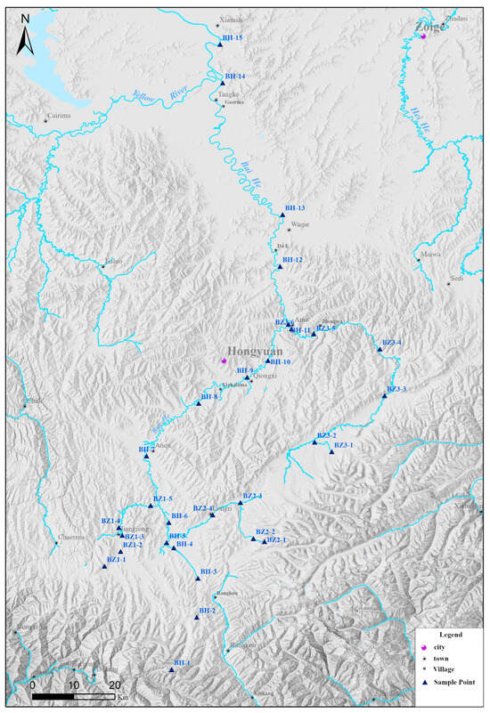
Figure 1


