


Infrastructures 2026, 11(7), 226; https://doi.org/10.3390/infrastructures11070226 - 1 Jul 2026
Abstract
This study addresses the impact of the location of transverse barriers on debris flow in the Libertad sub-basin, in Chosica, Peru. Intense seasonal rainfall in this region causes destructive flows that threaten infrastructure and human lives. Using geographic information system tools, hydrological models
[...] Read more.
This study addresses the impact of the location of transverse barriers on debris flow in the Libertad sub-basin, in Chosica, Peru. Intense seasonal rainfall in this region causes destructive flows that threaten infrastructure and human lives. Using geographic information system tools, hydrological models and hydraulic simulations, scenarios with barriers installed at different distances from the debris source were evaluated. The results indicate that the barrier located closest to the source (0.3L) is the most effective, achieving a reduction in velocity of 12.9% at the most critical urban monitoring point, the greatest volume retention capacity (790.02 m3), and the greatest decrease in flow escaping from the study area (65.7%). In contrast, barriers at 0.5L, 0.7L, and 0.9L show progressively lower effectiveness. This finding highlights the importance of a strategic design that optimises the position of the barriers according to the geomorphological and hydrological characteristics of the area. It is concluded that an adequate distribution of barriers, complemented with integrated watershed management strategies, can considerably mitigate the risks associated with debris flows in vulnerable urban areas.
Full article
(This article belongs to the Special Issue Advanced Technologies for Climate Resilient Infrastructures)
►
Show Figures
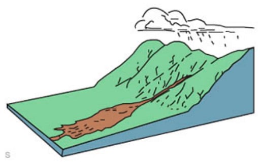
Figure 1


