Next Issue
Volume 17, June-2
Previous Issue
Volume 17, May-2
 
 
water-logo

Journal Browser

Journal Browser

Water, Volume 17, Issue 11 (June-1 2025) – 161 articles

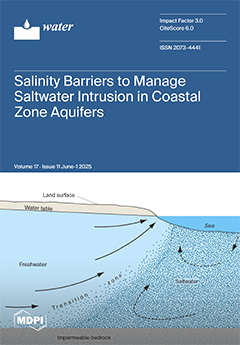
Cover Story (view full-size image): In the following study, eleven types of salinity barriers were investigated. The feasibility of the use of each salinity barrier type was evaluated within the context of the most recent projections of sea level changes. Key factors used in the evaluation included local hydrogeology, land surface slope, water use, the rate of sea level rise, technical feasibility (operational track record), and economics. View this paper
  • Issues are regarded as officially published after their release is announced to the table of contents alert mailing list.
  • You may sign up for e-mail alerts to receive table of contents of newly released issues.
  • PDF is the official format for papers published in both, html and pdf forms. To view the papers in pdf format, click on the "PDF Full-text" link, and use the free Adobe Reader to open them.
Order results
Result details
Section
Select all
Export citation of selected articles as:
18 pages, 4380 KiB  
Article
Deep Learning-Based Retrieval of Chlorophyll-a in Lakes Using Sentinel-1 and Sentinel-2 Satellite Imagery
by Bongseok Jeong, Sunmin Lee, Joonghyeok Heo, Jeongho Lee and Moung-Jin Lee
Water 2025, 17(11), 1718; https://doi.org/10.3390/w17111718 - 5 Jun 2025
Viewed by 561
Abstract
Remote sensing and AI models have been utilized for monitoring Chlorophyll-a (Chl-a), a primary indicator of eutrophication across broad water bodies. Previous studies have primarily relied on optical remote sensing data for assessing Chl-a’s spectral characteristics. Synthetic-aperture radar (SAR) data, which contain valuable [...] Read more.
Remote sensing and AI models have been utilized for monitoring Chlorophyll-a (Chl-a), a primary indicator of eutrophication across broad water bodies. Previous studies have primarily relied on optical remote sensing data for assessing Chl-a’s spectral characteristics. Synthetic-aperture radar (SAR) data, which contain valuable information about surface algae containing Chl-a, remains underutilized despite its high potential for improving Chl-a retrieval accuracy. Therefore, this study aims to develop a Convolutional neural network (CNN) based Chl-a retrieval model utilizing both SAR data and optical data in Korean lakes. The model dataset was established by acquiring Chl-a concentration data and Sentinel-1/2 imagery from the Copernicus Open Access Hub. The CNN model trained on both optical and SAR data exhibited superior performance (R2 = 0.7992, RMSE = 10.3282 mg/m3, RPD = 2.2315) compared with the model trained exclusively on optical data. Moreover, SAR data exhibited moderate variable importance among all variables, demonstrating their efficacy as input variables for Chl-a concentration estimation. Furthermore, the CNN model estimated Chl-a concentrations with a spatial distribution that matched the observed spatial heterogeneity of Chl-a concentrations. These results are expected to serve as a foundation for future research on remote monitoring of Chl-a using such data. Full article
Show Figures

Figure 1

15 pages, 1004 KiB  
Article
Survey of School Direct-Drinking Water Access for Children and Youth in Shanghai, China
by Yuan-Shen Zhu, Bing-Qing Hu, Rong Zheng, Ya-Juan Wang, Wei-Wei Zheng and Min-Juan Yang
Water 2025, 17(11), 1717; https://doi.org/10.3390/w17111717 - 5 Jun 2025
Viewed by 359
Abstract
Background: Over the past decade, Shanghai primary and middle schools have installed and updated direct-drinking water facilities in compliance with local policies, but few studies have assessed the schools providing direct-drinking water access. Methods: A cross-sectional study was conducted with 167 public primary, [...] Read more.
Background: Over the past decade, Shanghai primary and middle schools have installed and updated direct-drinking water facilities in compliance with local policies, but few studies have assessed the schools providing direct-drinking water access. Methods: A cross-sectional study was conducted with 167 public primary, middle, and high schools across Pudong New Area, Shanghai during Autumn 2024. The type, location, and working condition of all direct-drinking water facilities throughout each school were documented by trained research staff using a direct observation protocol. Information on school direct-drinking water quality was obtained from the routine monitoring program. Data were analyzed for comprehensive assessment of direct-drinking water facilities in the schools. Results: On average, each school had one faucet of direct-water facility per 41 students; 70% of the schools met the requirement for minimum direct-drinking water access, and >90% placed facilities in high-traffic areas. In addition, 83% of the schools selected water facilities with nanofiltration and a hot water system, and most only provided hot water (above 50 degrees Celsius). For school direct-drinking water quality, the concentrations of hardness, chemical oxygen demand (COD), and total dissolved solids (TDS), as well as pH values, were improved significantly, but the total bacteria count was prone to not meeting the requirement for standards in middle and high schools, which could be caused by insufficiency of chlorination in pumping stations or neglecting to clean facilities promptly. Conclusions: Wide usage of school direct-drinking water facilities could help most public schools to meet local policies for minimum student drinking water access in Shanghai, but microbial contamination was the potential threat. Water temperature is the key factor affecting students’ drinking water, providing an optional water temperature for students’ preferences and concerns. National sanitary standards of direct-drinking water quality and relevant additional regulations should be established and implemented in China. Full article
(This article belongs to the Special Issue Design and Management of Water Distribution Systems)
Show Figures

Figure 1

16 pages, 1698 KiB  
Article
Dark Fermentation of Sizing Process Waste: A Sustainable Solution for Hydrogen Production and Industrial Waste Management
by Marlena Domińska, Martyna Gloc, Magdalena Olak-Kucharczyk and Katarzyna Paździor
Water 2025, 17(11), 1716; https://doi.org/10.3390/w17111716 - 5 Jun 2025
Viewed by 369
Abstract
The possibility of hydrogen (H2) production from sizing waste, specifically starch-based substrates, was investigated through dark fermentation. Modified starch substrates produced less (up to 54% without heating and 18% after heating) H2 than natural ones. However, heating modified starch samples [...] Read more.
The possibility of hydrogen (H2) production from sizing waste, specifically starch-based substrates, was investigated through dark fermentation. Modified starch substrates produced less (up to 54% without heating and 18% after heating) H2 than natural ones. However, heating modified starch samples led to 18% higher H2 production than unheated ones, suggesting that high temperatures activate more favorable metabolic pathways. The highest H2 production (215 mL/gTVS_substrate) was observed with unheated natural starch, where the classic butyric–acetic fermentation pathway predominated. This variant also generated the highest CO2 levels (250 mL/gTVS_substrate), confirming the correlation between H2 and CO2 production in these pathways. Modified starch substrates shifted fermentation towards fatty acid chain elongation, reducing CO2 production. The proportion of CO2 in the fermentation gases correlated strongly with H2 production across all variants. A decrease in total volatile solids (TVS) indicated effective organic matter conversion, while varying dissolved organic carbon (DOC) levels suggested different degradation rates. Nitrogen analysis (TN) revealed that the differences between variants were due to varying nitrogen processing mechanisms by microorganisms. These results highlight the potential of sizing waste as a substrate for bioH2 production and offer insights for optimizing the process and developing industrial technologies for bioH2 and other valuable products. Full article
(This article belongs to the Special Issue Novel Methods in Wastewater and Stormwater Treatment)
Show Figures

Figure 1

18 pages, 4854 KiB  
Article
Comparing UAV-Based Hyperspectral and Satellite-Based Multispectral Data for Soil Moisture Estimation Using Machine Learning
by Hadi Shokati, Mahmoud Mashal, Aliakbar Noroozi, Saham Mirzaei, Zahra Mohammadi-Doqozloo, Kamal Nabiollahi, Ruhollah Taghizadeh-Mehrjardi, Pegah Khosravani, Rabindra Adhikari, Ling Hu and Thomas Scholten
Water 2025, 17(11), 1715; https://doi.org/10.3390/w17111715 - 5 Jun 2025
Viewed by 538
Abstract
Accurate estimation of soil moisture content (SMC) is crucial for effective water management, enabling improved monitoring of water stress and a deeper understanding of hydrological processes. While satellite remote sensing provides broad coverage, its spatial resolution often limits its ability to capture small-scale [...] Read more.
Accurate estimation of soil moisture content (SMC) is crucial for effective water management, enabling improved monitoring of water stress and a deeper understanding of hydrological processes. While satellite remote sensing provides broad coverage, its spatial resolution often limits its ability to capture small-scale variations in SMC, especially in landscapes with diverse land-cover types. Unmanned aerial vehicles (UAVs) equipped with hyperspectral sensors offer a promising solution to overcome this limitation. This study compares the effectiveness of Sentinel-2, Landsat-8/9 multispectral data and UAV hyperspectral data (from 339.6 nm to 1028.8 nm with spectral bands) in estimating SMC in a research farm consisting of bare soil, cropland and grassland. A DJI Matrice 100 UAV equipped with a hyperspectral spectrometer collected data on 14 field campaigns, synchronized with satellite overflights. Five machine-learning algorithms including extreme learning machines (ELMs), Gaussian process regression (GPR), partial least squares regression (PLSR), support vector regression (SVR) and artificial neural network (ANN) were used to estimate SMC, focusing on the influence of land cover on the accuracy of SMC estimation. The findings indicated that GPR outperformed the other models when using Landsat-8/9 and hyperspectral photography data, demonstrating a tight correlation with the observed SMC (R2 = 0.64 and 0.89, respectively). For Sentinel-2 data, ELM showed the highest correlation, with an R2 value of 0.46. In addition, a comparative analysis showed that the UAV hyperspectral data outperformed both satellite sources due to better spatial and spectral resolution. In addition, the Landsat-8/9 data outperformed the Sentinel-2 data in terms of SMC estimation accuracy. For the different land-cover types, all types of remote-sensing data showed the highest accuracy for bare soil compared to cropland and grassland. This research highlights the potential of integrating UAV-based spectroscopy and machine-learning techniques as complementary tools to satellite platforms for precise SMC monitoring. The findings contribute to the further development of remote-sensing methods and improve the understanding of SMC dynamics in heterogeneous landscapes, with significant implications for precision agriculture. By enhancing the SMC estimation accuracy at high spatial resolution, this approach can optimize irrigation practices, improve cropping strategies and contribute to sustainable agricultural practices, ultimately enabling better decision-making for farmers and land managers. However, its broader applicability depends on factors such as scalability and performance under different conditions. Full article
Show Figures

Figure 1

39 pages, 31656 KiB  
Article
Assessment of Satellite and Reanalysis Precipitation Data Using Statistical and Wavelet Analysis in Semi-Arid, Morocco
by Achraf Chakri, Nour-Eddine Laftouhi, Lahcen Zouhri, Hassan Ibouh and Mounsif Ibnoussina
Water 2025, 17(11), 1714; https://doi.org/10.3390/w17111714 - 5 Jun 2025
Viewed by 450
Abstract
Climate change, marked by decreasing rainfall and increasing extreme events, represents a major challenge for water resources, particularly in semi-arid regions. To estimate aquifer recharge, it is essential to assess the fraction of precipitation contributing to groundwater recharge and to implement a water [...] Read more.
Climate change, marked by decreasing rainfall and increasing extreme events, represents a major challenge for water resources, particularly in semi-arid regions. To estimate aquifer recharge, it is essential to assess the fraction of precipitation contributing to groundwater recharge and to implement a water balance model. However, the limited number of rainfall stations has led researchers to rely on satellite and reanalysis rainfall products. The accuracy of these datasets is essential for reliable hydrological modeling. In this study, we evaluated five rainfall products—CHIRPS, ERA5_Ag, CFSR, GPM, and PERSIANN-CDR—by comparing them to ground measurements from gauging stations in the central Haouz region of Marrakech. The evaluation was conducted at three temporal scales: daily, monthly, and annual. Statistical metrics, including RMSE, MAE, NSE, Bias, and Pearson correlation, as well as classification metrics (accuracy, F1 score, recall, precision, and Cohen’s Kappa), and wavelet analysis, were applied to assess the accuracy of the products. The results identified ERA5_Ag and GPM as the most accurate products in capturing rainfall events. Nevertheless, ERA5_Ag showed a high bias. After applying the quantile mapping method to correct the bias, the product exhibited greater accuracy. The corrected datasets from these two products will be used to estimate recharge over the last 30 years, contributing to the development of a hydrogeological model for groundwater dynamics. Full article
(This article belongs to the Special Issue Hydrogeological and Hydrochemical Investigations of Aquifer Systems)
Show Figures

Graphical abstract

19 pages, 2708 KiB  
Article
Simulation of Extreme Hydrographs in Heterogeneous Catchments with Limited Data
by Alfonso Arrieta-Pastrana, Oscar E. Coronado-Hernández and Helena M. Ramos
Water 2025, 17(11), 1713; https://doi.org/10.3390/w17111713 - 5 Jun 2025
Viewed by 385
Abstract
Rainfall-based methods have been employed for computing hydrographs in urban drainage systems. However, their implementation often introduces uncertainty in various aspects, such as the selection of a unit hydrograph, the choice of abstraction methods, and the formulas used to calculate the time of [...] Read more.
Rainfall-based methods have been employed for computing hydrographs in urban drainage systems. However, their implementation often introduces uncertainty in various aspects, such as the selection of a unit hydrograph, the choice of abstraction methods, and the formulas used to calculate the time of concentration, among others. Conventional consultancy studies tend to oversimplify catchment representation by treating it as a homogeneous unit or discretizing it into a few segments with simplified flood routing. This research proposes a streamlined methodology for computing hydrographs, considering the sub-basins’ heterogeneity. The methodology is based on the principles of proportionality and superposition. A sensitivity analysis of the proposed methodology is conducted, considering both homogeneous and heterogeneous catchments and the temporal distribution of rainfall. The proposed methodology is applied to the catchment of the Ricaurte channel, located in Cartagena de Indias (Colombia), with a watershed area of 728.8 ha. It has proven effective in representing a recorded simultaneous rainfall-runoff event, achieving a Root Mean Square Error of 3.93% in estimating the total volume of the measured hydrographs. A key advantage of the methodology, compared to traditional rainfall–runoff approaches, is that it does not require an extensive number of parameters to be calibrated. It may be utilized to estimate extreme flood events in urban areas with limited data availability, relying on minimal data inputs. Full article
(This article belongs to the Section Hydrology)
Show Figures

Figure 1

12 pages, 1337 KiB  
Article
Effects of BDE3 and the Co-Existence Copper on Photosynthesis and Antioxidative Enzymes in Salvinia natans (L.)
by Yao Yao, Bin Long, Mengjie Zhu, Simin Zhang, He Liu and Liyan Tian
Water 2025, 17(11), 1712; https://doi.org/10.3390/w17111712 - 5 Jun 2025
Viewed by 364
Abstract
Due to the unregulated handling of e-waste, the co-existence of PBDEs and heavy metals in water bodies and soil has been detected with high frequency. However, the combined toxicity for aquatic creatures remains unclear. This study investigated the single and combined stress of [...] Read more.
Due to the unregulated handling of e-waste, the co-existence of PBDEs and heavy metals in water bodies and soil has been detected with high frequency. However, the combined toxicity for aquatic creatures remains unclear. This study investigated the single and combined stress of BDE3 and copper on the photosynthesis and antioxidant enzyme system of Salvinia natans (L.). The results indicated that there were no negative effects on photosynthetic pigments under single stress of BDE3 or combined stress with copper. However, to deal with oxidative stress, antioxidant defense enzymes, including SOD and CAT, were activated in S. natans. SOD was sensitive in the first stage, while CAT activity was significantly increased until the end of 14 days of incubation. Malondialdehyde content increased significantly, which indicated that excessive reactive oxygen species from pollution of BDE3 or coexistence with copper could not be eliminated. BDE3 concentration in the aqueous phase declined with time, while copper was accumulated over time in S. natans, with BCF increasing to 0.31 ± 0.073 at the end. Our study indicated that the co-existence of copper could exacerbate the damage caused by BDE3 to S. natans in aqueous environment. Full article
Show Figures

Figure 1

2 pages, 129 KiB  
Correction
Correction: Li et al. Geographic Exposomics of Cardiac Troponin I Reference Intervals in Chinese Adults: Climate-Topography Coupling-Driven Spatial Prediction and Health Risk Assessment. Water 2025, 17, 1426
by Tianyu Li, Jiayu Zhang, Xinfeng Zhao and Zihao Wu
Water 2025, 17(11), 1711; https://doi.org/10.3390/w17111711 - 5 Jun 2025
Viewed by 239
Abstract
In the original publication [...] Full article
16 pages, 2426 KiB  
Article
Seasonal Distribution of Microbial Community and n-Alkane Functional Genes in Diesel-Contaminated Groundwater: Influence of Water Table Fluctuation
by Xuefeng Xia, Wenjuan Jia, Kai Wang and Aizhong Ding
Water 2025, 17(11), 1710; https://doi.org/10.3390/w17111710 - 4 Jun 2025
Viewed by 377
Abstract
Water table fluctuation alters environment properties and n-alkane transformation, leading to shifts in the groundwater microbial community and functions. A diesel-contaminated aquifer column experiment of seasonal water table fluctuation was designed to explore the mechanisms. Temporal changes in geochemical parameters, n-alkane concentration, bacterial [...] Read more.
Water table fluctuation alters environment properties and n-alkane transformation, leading to shifts in the groundwater microbial community and functions. A diesel-contaminated aquifer column experiment of seasonal water table fluctuation was designed to explore the mechanisms. Temporal changes in geochemical parameters, n-alkane concentration, bacterial community and functional gene composition were investigated. The results showed that water table fluctuation accelerated the depletion of the diesel n-alkane leakage point. Owing to the variations in the water table, the electron donors (dissolved organic carbon) and electron acceptors (dissolved oxygen, nitrate and sulfate) underwent regular changes, and the bacterial community structure was altered. Dissolved oxygen was the major parameter correlating with the abundance of aerobic functional genes (the sum of the alk_A, alk_R and alk_P) and was beneficial for enhancing the aerobic biodegradation function potential of n-alkanes. However, the static retention of the water table at the highest level inducing water saturation and hypoxia was the critical factor influencing the abundance of anaerobic functional genes (the sum of assA and mcrA) and was favorable for the anaerobic biodegradation function potential of n-alkane. Overall, this study links seasonal water table dynamics to n-alkane biodegradation function potential in aquifers, and suggests that the quality of recharge water, which impacts microbial community assembly and function, should be considered. Full article
(This article belongs to the Special Issue Application of Bioremediation in Groundwater and Soil Pollution)
Show Figures

Figure 1

25 pages, 2916 KiB  
Review
Navigating the Depths: A Comprehensive Review of 40 Years of Marine Oil Pollution Studies in the Philippines (1980 to 2024)
by Hernando P. Bacosa, Jill Ruby L. Parmisana, Nur Inih U. Sahidjan, Joevin Mar B. Tumongha, Keana Aubrey A. Valdehueza, Jay Rumen U. Maglupay, Andres Philip Mayol, Chin-Chang Hung, Marianne Faith Martinico-Perez, Kozo Watanabe, Mei-Fang Chien and Chihiro Inoue
Water 2025, 17(11), 1709; https://doi.org/10.3390/w17111709 - 4 Jun 2025
Viewed by 695
Abstract
This review synthesizes four decades (1980–2024) of marine oil spill research in the Philippines, analyzing 80 peer-reviewed publications sourced from Scopus, Web of Science, Clarivate, and Google Scholar. Findings show that oil spill research activity spikes after major spills, particularly the 2006 Guimaras [...] Read more.
This review synthesizes four decades (1980–2024) of marine oil spill research in the Philippines, analyzing 80 peer-reviewed publications sourced from Scopus, Web of Science, Clarivate, and Google Scholar. Findings show that oil spill research activity spikes after major spills, particularly the 2006 Guimaras incident, which accounts for over half of the reviewed studies and were mostly concentrated in the field of biology, followed by social sciences. Mangroves are the most studied as they are the widely affected ecosystem in the Philippines. Despite the number of published articles on oil spills in the Philippines, only the major events were emphasized, and small-scale spills remain under documented. Research on small-scale oil spills and the country’s two recent big oil spills (Mindoro Oil Spill and Manila Bay Oil Spill), particularly in a country’s environmentally sensitive areas, must be conducted in collaboration with academic institutions and relevant stakeholders to gain a deeper understanding and formulate appropriate countermeasures in the event of future spills. The review also highlights limited application of advanced techniques such as hydrocarbon fingerprinting, geospatial analysis, and next-generation DNA sequencing, limiting comprehensive assessments of oil fate and ecological effects. Addressing these gaps through interdisciplinary collaboration is critical to improving oil spill response, environmental management, and policy formulation in the Philippines’ complex archipelagic setting. Full article
Show Figures

Figure 1

22 pages, 2615 KiB  
Article
Degradation of 1,4-Dioxane by Au/TiO2 Janus Nanoparticles Under Ultraviolet Light: Experiments and Modeling
by Yangyuan Ji, Matthew J. Tao, Lamar O. Mair, Amit Kumar Singh, Yuhang Fang, Sathish Rajendran, Thomas E. Beechem, David M. Warsinger and Jeffrey L. Moran
Water 2025, 17(11), 1708; https://doi.org/10.3390/w17111708 - 4 Jun 2025
Viewed by 487
Abstract
Advanced oxidation processes (AOPs) show significant promise to degrade recalcitrant water contaminants, such as 1,4-dioxane, but slow degradation kinetics limit the energy efficiency of this technology. We realized substantial enhancements in the degradation of 1,4-dioxane (a suspected carcinogen) using gold-coated titanium dioxide (Au/TiO [...] Read more.
Advanced oxidation processes (AOPs) show significant promise to degrade recalcitrant water contaminants, such as 1,4-dioxane, but slow degradation kinetics limit the energy efficiency of this technology. We realized substantial enhancements in the degradation of 1,4-dioxane (a suspected carcinogen) using gold-coated titanium dioxide (Au/TiO2) Janus nanoparticles (JNPs) irradiated with above-bandgap ultraviolet (UV) light (peak wavelength, 254 nm). To explain this result, we combined experimental measurements quantifying 1,4-dioxane degradation at varying UV wavelengths with finite-element simulations that provided explanatory insight into the light–matter interactions at play. The enhanced photocatalytic activity at the optimal condition (254 nm light, high intensity, Au/TiO2) resulted from a larger quantity of photogenerated holes in the TiO2 capable of reacting with water to form hydroxyl radicals that degrade 1,4-dioxane. This increased production of holes resulted from two sources: (1) more viable electron–hole pairs were created under 254 nm light owing to increased light absorption by the TiO2 that was localized near the surface; (2) the metal sequestered photogenerated electrons from the TiO2, which prevented electron–hole pairs from recombining, leaving more holes available to react with water. Our results motivate the exploration of different metal coatings (especially non-precious metals) and suggest a path toward broader implementation of TiO2-based photocatalytic AOPs, which can effectively remove many water pollutants that survive conventional treatment techniques. Full article
(This article belongs to the Special Issue Water Treatment Technology for Emerging Contaminants, 2nd Edition)
Show Figures

Graphical abstract

29 pages, 1302 KiB  
Review
Artificial Intelligence (AI) in Surface Water Management: A Comprehensive Review of Methods, Applications, and Challenges
by Jerome G. Gacu, Cris Edward F. Monjardin, Ronald Gabriel T. Mangulabnan, Gerald Christian E. Pugat and Jerose G. Solmerin
Water 2025, 17(11), 1707; https://doi.org/10.3390/w17111707 - 4 Jun 2025
Cited by 1 | Viewed by 1865
Abstract
Surface water systems face unprecedented stress due to climate variability, urbanization, land-use change, and growing water demand—prompting a shift from traditional hydrological modeling to intelligent, adaptive systems. This review critically explores the integration of Artificial Intelligence (AI) in surface flow management, encompassing applications [...] Read more.
Surface water systems face unprecedented stress due to climate variability, urbanization, land-use change, and growing water demand—prompting a shift from traditional hydrological modeling to intelligent, adaptive systems. This review critically explores the integration of Artificial Intelligence (AI) in surface flow management, encompassing applications in streamflow forecasting, sediment transport, flood prediction, water quality monitoring, and infrastructure operations such as dam and irrigation control. Drawing from over two decades of interdisciplinary literature, this study synthesizes recent advances in machine learning (ML), deep learning (DL), the Internet of Things (IoT), remote sensing, and hybrid AI–physics models. Unlike earlier reviews focusing on single aspects, this paper presents a systems-level perspective that links AI technologies to their operational, ethical, and governance dimensions. It highlights key AI techniques—including Long Short-Term Memory (LSTM), Convolutional Neural Networks (CNNs), Graph Neural Networks (GNNs), Transformer models, and Reinforcement Learning—and discusses their strengths, limitations, and implementation challenges, particularly in data-scarce and climate-uncertain regions. Novel insights are provided on Explainable AI (XAI), algorithmic bias, cybersecurity risks, and institutional readiness, positioning this paper as a roadmap for equitable and resilient AI adoption. By combining methodological analysis, conceptual frameworks, and future directions, this review offers a comprehensive guide for researchers, engineers, and policy-makers navigating the next generation of intelligent surface flow management. Full article
Show Figures

Figure 1

21 pages, 931 KiB  
Article
Does the Belt and Road Initiative Affect the Trade in Virtual Water Imports of Grain? Evidence from China
by Junying Wang, Hao Ji, Lan Yao, Muhammad Naeem and Irfan Saleem
Water 2025, 17(11), 1706; https://doi.org/10.3390/w17111706 - 4 Jun 2025
Viewed by 353
Abstract
Based on trade data from 2005 to 2020, this study investigates the driving forces behind China’s grain virtual water (VW) import trade, with a particular focus on the role of the Belt and Road Initiative (BRI). By incorporating economic distance (ED) and institutional [...] Read more.
Based on trade data from 2005 to 2020, this study investigates the driving forces behind China’s grain virtual water (VW) import trade, with a particular focus on the role of the Belt and Road Initiative (BRI). By incorporating economic distance (ED) and institutional distance (ID) into the gravity model framework and applying a high-dimensional fixed-effects Poisson pseudo-maximum likelihood estimation method, the study offers new empirical insights. The results indicate that ED is negatively associated with virtual water trade (VWT) in grains, while ID exhibits an inverted U-shaped relationship with VWT. Furthermore, the BRI significantly moderates the effects of ED and ID, weakening their influence on VWT. Additionally, the initiative demonstrates a clear trade creation effect, promoting increased VW imports. These findings contribute to a deeper understanding of the mechanisms shaping VWT and offer valuable policy guidance for enhancing international cooperation under the BRI framework. Full article
(This article belongs to the Section Water Resources Management, Policy and Governance)
Show Figures

Figure 1

23 pages, 11459 KiB  
Article
Urban Flood Model-Driven Optimization of Flood Control and Drainage Engineering Solutions
by Yunning Liu, Wenbin Zang, Baoqi Li, Fuxin Chai and Xunping Liu
Water 2025, 17(11), 1705; https://doi.org/10.3390/w17111705 - 4 Jun 2025
Viewed by 409
Abstract
With the rapid advances of global climate change and urbanization, urban flooding is causing greater losses. Existing urban flood control and drainage engineering design standards are often applied to single projects. This paper proposes a set of urban flood model-driven optimization of flood [...] Read more.
With the rapid advances of global climate change and urbanization, urban flooding is causing greater losses. Existing urban flood control and drainage engineering design standards are often applied to single projects. This paper proposes a set of urban flood model-driven optimization of flood control and drainage engineering solutions. Applied to Shenzhen’s Shawan interception project, the preferred option demonstrates significant improvements, such as the following: a 25% reduction ratio of the maximum designed water depth at key points of the Shawan River main stream, a 0.26% reduction in the maximum submerged area of the urban surface, a 3.27% reduction in the full pipe rate of drainage pipe, and a 10.81% reduction in the overflow rate of inspection wells. The comprehensive flood control and drainage benefits are the best, and they achieve the solution of problems within the basin. Aiming at the shortage of comprehensive consideration of project scale, combination mode, and control scheme in urban flood control planning and design, this simulation scheme proposes a set of detailed design technologies of urban flood control engineering based on a flood numerical model. The analysis results show that the ideas proposed in this paper can provide a reference for the design of urban flood control and drainage engineering. Full article
(This article belongs to the Section Urban Water Management)
Show Figures

Figure 1

27 pages, 1827 KiB  
Review
Stormwater Pollution of Non-Urban Areas—A Review
by Antonia Potreck and Jens Tränckner
Water 2025, 17(11), 1704; https://doi.org/10.3390/w17111704 - 4 Jun 2025
Viewed by 440
Abstract
Stormwater runoff from areas with specific industrial, agricultural or logistic land use comprises a significant source of water pollution, yet research on its specific composition remains limited compared to urban stormwater pollution. This review synthesizes findings from different studies to analyze sampling methods, [...] Read more.
Stormwater runoff from areas with specific industrial, agricultural or logistic land use comprises a significant source of water pollution, yet research on its specific composition remains limited compared to urban stormwater pollution. This review synthesizes findings from different studies to analyze sampling methods, types of pollution parameters and their associated concentration ranges across various non-urban land use types, including industrial and commercial zones, transportation infrastructure (ports, airports, highways, railways) and agricultural areas. Studies differed in sample strategy, investigated phase (water, sediment) and analyzed chemical parameters. The latter can be grouped into sum parameters (e.g., total suspended solids (TSS), chemical oxygen demand (COD)), metals (e.g., nickel, copper, zinc, lead), nutrients (e.g., nitrogen, phosphorus), organic micropollutants (e.g., polycyclic aromatic hydrocarbons (PAH), perfluoroalkyl acids (PFAA)) and microbial contaminants. Results indicate that pollutant loads vary widely depending on land use, with industrial and railway areas showing the highest metal contamination, while agricultural and livestock farming areas exhibit elevated nutrient and microbial concentrations. The heterogeneity of the sampling, analysis and subsequent data processing hindered the statistical condensation of data from different studies. The findings underscore the need for standardized monitoring methods and tailored stormwater treatment strategies to mitigate pollution impact effectively. Full article
(This article belongs to the Special Issue Advances in Sustainable Management of Contaminated Stormwater)
Show Figures

Figure 1

23 pages, 8720 KiB  
Article
Meaningful Multi-Stakeholder Participation via Social Media in Coastal Fishing Village Spatial Planning and Governance
by Jing Wang, Ming-Ming He, Su-Hsin Lee and Shu-Chen Tsai
Water 2025, 17(11), 1703; https://doi.org/10.3390/w17111703 - 4 Jun 2025
Viewed by 450
Abstract
Due to the rapid development of China’s economy, the current situation of fishing villages in the southeastern coastal areas is spatial disorder caused by changes in population composition and industrial transformation. This study analyses the differences between the clan structure and the multi-stakeholder [...] Read more.
Due to the rapid development of China’s economy, the current situation of fishing villages in the southeastern coastal areas is spatial disorder caused by changes in population composition and industrial transformation. This study analyses the differences between the clan structure and the multi-stakeholder engagement model in traditional fishing villages. The main aim is to illustrate contemporary issues that fishing villages’ spaces need to deal with in governance and decision making. With the development of information technology, social media has become an important platform through which stakeholders can communicate and make decisions. The aims of this paper were as follows: (1) Identify the stakeholders involved in the governance of fishing villages; (2) explore how stakeholders participate in the planning and governance of fishing villages through social media; (3) examine the mechanisms of social media and its impact on the spatial planning of fishing villages. Through qualitative research methods such as field surveys and in-depth interviews, the following results were obtained: (1) Social media subverts the traditional fishing village governance model, and the scope of the governance subject is expanded; (2) spatial changes in fishing villages are affected by the joint influence of people, the environment, and the economy, and a social network acts as an intermediary to compensate for the deficiencies that existed in previous fishing village governance processes. Full article
(This article belongs to the Special Issue Coastal and Marine Governance and Protection)
Show Figures

Figure 1

24 pages, 4547 KiB  
Article
Future Changes in Precipitation Extremes over South Korea Based on Observations and CMIP6 SSP Scenarios
by Sunghun Kim, Ju-Young Shin, Gayoung Lee, Jiyeon Park and Kyungmin Sung
Water 2025, 17(11), 1702; https://doi.org/10.3390/w17111702 - 4 Jun 2025
Viewed by 811
Abstract
This research assesses four Shared Socioeconomic Pathway (SSP) scenarios (SSP1-2.6, SSP2-4.5, SSP3-7.0, SSP5-8.5) concerning precipitation quantiles across Korea, utilizing the CMIP6 multi-model ensemble comprising 23 General Circulation Models alongside observational data to project future changes. Precipitation quantiles, derived from regional frequency analysis conducted [...] Read more.
This research assesses four Shared Socioeconomic Pathway (SSP) scenarios (SSP1-2.6, SSP2-4.5, SSP3-7.0, SSP5-8.5) concerning precipitation quantiles across Korea, utilizing the CMIP6 multi-model ensemble comprising 23 General Circulation Models alongside observational data to project future changes. Precipitation quantiles, derived from regional frequency analysis conducted at 615 sites, are calculated as annual averages for the period from 2015 to 2024. Each SSP scenario is evaluated for its spatial distribution through the application of observational data and chi-square tests, with the results indicating that the SSP3-7.0 ensemble most accurately reflects the current quantile estimates derived from observational data. Furthermore, interannual precipitation quantiles are projected to extend to the year 2100 to discern long-term trends within each reproducible period. It is anticipated that precipitation associated with the 100-year reproducible period will increase by over 20% in most regions across the nation by the century’s end, with this increase becoming more pronounced in accordance with the severity of the pathway. These findings underscore significant increases in extreme rainfall events under high-emission scenarios and highlight the critical need for the integration of enhanced flood mitigation, water resource management, and climate adaptation strategies within Korea’s planning framework. Full article
(This article belongs to the Section Water and Climate Change)
Show Figures

Figure 1

17 pages, 5033 KiB  
Article
Dynamics of Nitrogen and Phosphorus Release from Submerged Soil–Plant Systems in the Three Gorges Reservoir
by Lei Hu, Liwei Xiao and Tao Wang
Water 2025, 17(11), 1701; https://doi.org/10.3390/w17111701 - 4 Jun 2025
Viewed by 526
Abstract
The water-level fluctuation zone (WLFZ) in the Three Gorges Reservoir (TGR) has attracted significant attention because of its pivotal role in shaping environmental processes. However, with the increasing water level, the effects of nitrogen and phosphorus release from submerged soil–plant systems in the [...] Read more.
The water-level fluctuation zone (WLFZ) in the Three Gorges Reservoir (TGR) has attracted significant attention because of its pivotal role in shaping environmental processes. However, with the increasing water level, the effects of nitrogen and phosphorus release from submerged soil–plant systems in the WLFZ on the deterioration in water quality remain poorly understood. In this study, a simulation experiment was conducted involving submerged undisturbed soil columns that was submerged once a year at different elevations (150, 160, and 170 m) before reservoir impoundment in the WLFZ within the TGR area. The results revealed that the concentrations of various forms of nitrogen and phosphorus in the overlying water released after system submergence first decreased, then rapidly increased after 30 days, and reached equilibrium after 120 days of flooding. Particulate N accounted for approximately 70% of the total nitrogen (TN) released, while particulate P accounted for more than 90% of the total phosphorus (TP) released by soil–plant systems after submergence for 200 days, which may be related to soil erosion and plant decomposition. The amounts of N and P released were significantly negatively correlated with the initial mass of the soil–plant system, indicating that nutrient release by the system is more susceptible to submerged soil than to submerged plants. During the flooding period of the WLFZ in the TGR, the release loads of soil–plant systems into reservoir water were 159.83 kg N ha−1 and 19.30 kg P ha−1. These results suggest that soil and plants in the WLFZ of the TGR could be at risk for water-induced deterioration. Therefore, additional vegetation management might be implemented to alleviate water eutrophication in the TGR caused by submerged soil and plants in the WLFZ. Full article
(This article belongs to the Special Issue Advanced Research in Non-Point Source Pollution of Watersheds)
Show Figures

Graphical abstract

26 pages, 7101 KiB  
Article
Enhancement of Electron Transfer Between Fe/Mn Promotes Efficient Activation of Peroxomonosulfate by FeMn-NBC
by Xiaoni Lin, Qiang Ge, Xianbo Zhou, Yan Wang, Congyun Zhu, Kuanyong Liu and Jinquan Wan
Water 2025, 17(11), 1700; https://doi.org/10.3390/w17111700 - 4 Jun 2025
Viewed by 541
Abstract
Bimetallic catalysts can effectively enhance the catalytic degradation efficiency of peroxymonosulfate (PMS), which is usually attributed to the enhancement of electron transfer, but currently, there is no clear explanation of the mechanism of how the electron transfer is enhanced. A nitrogen-doped Fe/Mn composite [...] Read more.
Bimetallic catalysts can effectively enhance the catalytic degradation efficiency of peroxymonosulfate (PMS), which is usually attributed to the enhancement of electron transfer, but currently, there is no clear explanation of the mechanism of how the electron transfer is enhanced. A nitrogen-doped Fe/Mn composite biochar (FeMn-NBC) was co-constructed by hydrothermal synthesis and high-temperature calcination. The FeMn-NBC activated PMS more efficiently than the monometallic one due to the enhanced electron transfer between Fe and Mn. The FeMn-NBC/PMS system activated PMS with Mn as the active center, and the high oxidation state of Mn4+ promoted the acceleration of the PMS adsorption of the generation of Mn2+/Mn3+. This gaining effect accelerated the electron cycling between Fe2+/Fe3+ and Mn2+/Mn3+/Mn4+, which enhanced the PMS catalysis to generate free radicals (•OH, SO4•− and •O2) and non-radicals (1O2) for the efficient degradation of diisobutyl phthalate (DIBP). Benefiting from this gaining effect, the degradation rate of DIBP by the FeMn-NBC/PMS system was increased by 2.43 and 3.38 times compared to Fe-NBC and Mn-NBC. The bimetallic-enhanced electron transfer mechanism proposed in this study facilitated the development of efficient catalysts for more efficient and selective removal of organic pollutants. Full article
(This article belongs to the Section Wastewater Treatment and Reuse)
Show Figures

Figure 1

24 pages, 3545 KiB  
Article
Leveraging Advanced Data-Driven Approaches to Forecast Daily Floods Based on Rainfall for Proactive Prevention Strategies in Saudi Arabia
by Anwar Ali Aldhafiri, Mumtaz Ali and Abdulhaleem H. Labban
Water 2025, 17(11), 1699; https://doi.org/10.3390/w17111699 - 3 Jun 2025
Viewed by 392
Abstract
Accurate flood forecasts are imperative to supervise and prepare for extreme events to assess the risks and develop proactive prevention strategies. The flood time-series data exhibit both spatial and temporal structures and make it challenging for the models to fully capture the embedded [...] Read more.
Accurate flood forecasts are imperative to supervise and prepare for extreme events to assess the risks and develop proactive prevention strategies. The flood time-series data exhibit both spatial and temporal structures and make it challenging for the models to fully capture the embedded features due to their complex stochastic nature. This paper proposed a new approach for the first time using variational mode decomposition (VMD) hybridized with Gaussian process regression (GPR) to design the VMD-GPR model for daily flood forecasting. First, the VMD model decomposed the (t − 1) lag into several signals called intrinsic mode functions (IMFs). The VMD has the ability to improve noise robustness, better mode separation, reduced mode aliasing, and end effects. Then, the partial auto-correlation function (PACF) was applied to determine the significant lag (t − 1). Finally, the PACF-based decomposed IMFs were sent into the GPR to forecast the daily flood index at (t − 1) for Jeddah and Jazan stations in Saudi Arabia. The long short-term memory (LSTM) boosted regression tree (BRT) and cascaded forward neural network (CFNN) models were combined with VMD to compare along with the standalone versions. The proposed VMD-GPR outperformed the comparing model to forecast daily floods for both stations using a set of performance metrics. The VMD-GPR outperformed comparing models by achieving R = 0.9825, RMSE = 0.0745, MAE = 0.0088, ENS = 0.9651, KGE = 0.9802, IA = 0.9911, U95% = 0.2065 for Jeddah station, and R = 0.9891, RMSE = 0.0945, MAE = 0.0189, ENS = 0.9781, KGE = 0.9849, IA = 0.9945, U95% = 0.2621 for Jazan station. The proposed VMD-GPR method efficiently analyzes flood events to forecast in these two stations to facilitate flood forecasting for disaster mitigation and enable the efficient use of water resources. The VMD-GPR model can help policymakers in strategic planning flood management to undertake mandatory risk mitigation measures. Full article
(This article belongs to the Section Hydrology)
Show Figures

Figure 1

24 pages, 7329 KiB  
Article
Integrated Groundwater Quality Assessment for Irrigation in the Ras El-Aioun District: Combining IWQI, GIS, and Machine Learning Approaches
by Zineb Mansouri, Haythem Dinar, Abdeldjalil Belkendil, Omar Bakelli, Tarek Drias, Amine Aymen Assadi, Lotfi Khezami and Lotfi Mouni
Water 2025, 17(11), 1698; https://doi.org/10.3390/w17111698 - 3 Jun 2025
Cited by 1 | Viewed by 361
Abstract
This study focuses on assessing the hydrogeochemical characteristics and irrigation suitability of groundwater in the Ras El Aioun and Merouana districts, using an integrated approach that combines physicochemical analysis, machine learning (ML), and Geographic Information Systems (GISs). Thirty groundwater samples were collected in [...] Read more.
This study focuses on assessing the hydrogeochemical characteristics and irrigation suitability of groundwater in the Ras El Aioun and Merouana districts, using an integrated approach that combines physicochemical analysis, machine learning (ML), and Geographic Information Systems (GISs). Thirty groundwater samples were collected in June 2023 and subjected to extensive analyses, including major ions (Ca2+, Mg2+, Na+, K+, HCO3, Cl, SO42−), pH, TDS, alkalinity, and hardness. Hydrochemical facies analysis revealed that the Ca-HCO3 type was dominant (93.33%), with some samples exceeding FAO limits, particularly for Na+, K+, SO42−, Cl, Mg2+, and HCO3. Assessment of groundwater irrigation suitability revealed generally favorable conditions based on three key parameters: all samples (100%) were classified as excellent based on the Sodium Adsorption Ratio (SAR < 10), 70% showed good-to-permissible status by Sodium Percentage (Na% < 60), and 83.3% were within safe limits for Residual Sodium Carbonate (RSC < 1.25 meq/L). However, the Permeability Index (PI > 75%) categorized 96.7% of samples as unsuitable for long-term irrigation due to potential soil permeability reduction. Additionally, Total Hardness (TH < 75 mg/L) indicated predominantly soft water characteristics (90% of samples), particularly in the central study area, suggesting possible limitations for certain agricultural applications that require mineral-rich water. GIS-based spatial analysis showed that irrigation suitability was higher in the eastern and western regions than in the central zone. Advanced machine learning algorithms provide superior predictive capability for water quality parameters by effectively modeling complex, non-linear feature interactions that conventional statistical approaches frequently fail to capture. Three ML models—Support Vector Regression (SVR), Random Forest (RF), and Extreme Gradient Boosting (XGBoost)—were used to predict the Irrigation Water Quality Index (IWQI). XGBoost outperformed the others (RMSE = 2.83, R2 = 0.957), followed by RF (RMSE = 3.12, R2 = 0.93) and SVR (RMSE = 3.45, R2 = 0.92). Integrating ML and GIS improved groundwater quality assessment and provided a robust framework for sustainable irrigation management. These findings provide critical insights for optimizing agricultural water use in water-scarce regions. Full article
(This article belongs to the Special Issue Global Water Resources Management)
Show Figures

Figure 1

37 pages, 3512 KiB  
Article
Performance of Combined Olive Mills Wastewater Treatment System: Electrocoagulation-Assisted Adsorption as a Post Polishing Sustainable Process
by Ahmad Jamrah, Tharaa M. Al-Zghoul, Zakaria Al-Qodah and Emad Al-Karablieh
Water 2025, 17(11), 1697; https://doi.org/10.3390/w17111697 - 3 Jun 2025
Viewed by 382
Abstract
This study investigates the effectiveness of electrocoagulation (EC) with locally sourced iron electrodes for treating olive mill wastewater (OMW) prior to adsorption with olive stone (OS). Using Response Surface Methodology (RSM), 60 experiments were conducted to evaluate various operational parameters, including current density [...] Read more.
This study investigates the effectiveness of electrocoagulation (EC) with locally sourced iron electrodes for treating olive mill wastewater (OMW) prior to adsorption with olive stone (OS). Using Response Surface Methodology (RSM), 60 experiments were conducted to evaluate various operational parameters, including current density (CD), reaction time (T), distance between electrodes (D), and the number of electrodes (N). The optimal conditions identified were a reaction time of 53.49 min, a current density of 15.1104 mA/cm2, 1 cm electrode spacing, and six electrodes. Under these conditions, the removal efficiencies achieved were 54.46% for total phenols (TPh), 73.25% for total Kjeldahl nitrogen (TKN), 92% for turbidity, 58.91% for soluble chemical oxygen demand (CODsoluble), and 58.55% for total COD (CODtotal), with an energy consumption of 14.3146 kWh/m3 and a projected cost of USD 3.92/m3. Following the EC process, the treated OMW underwent further adsorption using OS, enhancing pollutant removal. The combined EC and adsorption (ECA) method demonstrated superior performance, achieving TPh removal at 62.63%, TKN removal at 77.52%, and turbidity reduction at 83.73%. Additionally, CODtotal removal increased to 72.88% with CODsoluble removal at 70.04%. This integrated approach significantly improves pollutant removal, presenting a promising solution for effective OMW treatment. Full article
(This article belongs to the Section Wastewater Treatment and Reuse)
Show Figures

Figure 1

24 pages, 3457 KiB  
Article
Runoff and Drought Responses to Land Use Change and CMIP6 Climate Projections
by Tao Liu, Zhenjiang Si, Yan Liu, Longfei Wang, Yusu Zhao and Jing Wang
Water 2025, 17(11), 1696; https://doi.org/10.3390/w17111696 - 3 Jun 2025
Viewed by 488
Abstract
Climate and land use changes significantly affect runoff and hydrological drought, presenting challenges for water resource management. This study focuses on the Naoli River Basin, utilizing the SWAT model integrated with PLUS land use projections under the CMIP6 SSP245 and SSP585 scenarios to [...] Read more.
Climate and land use changes significantly affect runoff and hydrological drought, presenting challenges for water resource management. This study focuses on the Naoli River Basin, utilizing the SWAT model integrated with PLUS land use projections under the CMIP6 SSP245 and SSP585 scenarios to assess trends in runoff and drought characteristics from 2025 to 2100. The Standardized Runoff Index (SRI) and run theory are applied to analyze drought frequency and duration. Key findings include the following: (1) Under the SSP585 scenario (2061–2100), land use changes—specifically, a reduction in cropland and an increase in forest cover—resulted in a 12.59% decrease in runoff compared to the baseline period (1970–2014), with notable differences when considering climate-only scenarios. (2) The SSP585 scenario exhibits a significant rise in drought frequency and duration, particularly during summer, whereas SSP245 shows milder trends. (3) Based on the Taylor plot evaluation, the ensemble average MMM-Best (r = 0.80, RMSE = 26.15) has been identified as the optimal prediction model for the 2025–2100 period. Deviation analysis revealed that NorESM2-MM and IPSL-CM6A-LR demonstrated the greatest stability, while EC-Earth3 exhibited the largest deviation and highest uncertainty. (4) Land use changes under the SSP245 scenario help mitigate drought by enhancing water retention, although their effectiveness diminishes under SSP585 due to the dominant influence of climate factors, including increased temperature and precipitation variability. And (5) SRI-3 mutation analysis indicated that the mutation point occurred in July 2074 under the SSP245 scenario and in April 2060 under the SSP585 scenario (p < 0.05). The trend for SSP245 revealed significant fluctuations, with the number of crossover points rising to 40 following land use changes; conversely, the SSP585 trend remained stable with only seven crossover points, as high-emission scenarios predominantly influenced early mutations. These findings illuminate the interactive effects of land use and climate change, providing a scientific foundation for optimizing water resource management and developing effective drought mitigation strategies. Full article
Show Figures

Figure 1

20 pages, 14467 KiB  
Article
Optimization of 3D Borehole Electrical Resistivity Tomography (ERT) Measurements for Real-Time Subsurface Imaging
by Marios Karaoulis
Water 2025, 17(11), 1695; https://doi.org/10.3390/w17111695 - 3 Jun 2025
Viewed by 312
Abstract
In this work, we explore the optimization of 3D Electrical Resistivity Tomography (ERT) measurement protocols for a 3D borehole grid configuration. Currently, there is no widely accepted standard measurement scheme for such setups. The use of numerous electrodes and the possibility of cross-borehole [...] Read more.
In this work, we explore the optimization of 3D Electrical Resistivity Tomography (ERT) measurement protocols for a 3D borehole grid configuration. Currently, there is no widely accepted standard measurement scheme for such setups. The use of numerous electrodes and the possibility of cross-borehole configurations lead to an extremely large number of potential electrode combinations. However, not all these combinations contribute significantly to the final resistivity model, and a complete measurement cycle requires substantial time to perform. This becomes particularly problematic in dynamic subsurface conditions, where changes may occur during data acquisition. In such cases, the measurements collected within a single cycle may reflect different subsurface states. Conversely, attempting to shorten acquisition time can result in too few measurements to resolve the subsurface structure at high resolution. Furthermore, most existing approaches assume a uniform half-space model and treat all measurements equally, failing to prioritize those that are most sensitive to actual subsurface changes. To address these challenges, we propose a 3D measurement optimization approach that yields an efficient acquisition scheme. This method produces inversion results comparable to those obtained from much larger datasets while reducing both measurement and processing requirements. Our optimization is based on a sensitivity-driven selection algorithm that accounts for the real subsurface structure rather than assuming a generic half-space. The proposed methodology is validated using synthetic data and tested with experimental data obtained from a laboratory tank setup. These experimental measurements were used to monitor permeation grouting; a technique applied to reduce permeability and/or increase the strength of granular soils through targeted injection. Full article
(This article belongs to the Special Issue Application of Geophysical Methods for Hydrogeology—Second Edition)
Show Figures

Figure 1

15 pages, 3679 KiB  
Article
Research on the Influence of River Morphological Changes on Water Self-Purification Capacity: A Case Study of the Shiwuli River in Chaohu Basin
by Chenguang Xiao, Zengyuan Chai, Dan Chen, Zhaohui Luo, Yuke Li, Qijun Ou and Yuchuan Zhang
Water 2025, 17(11), 1694; https://doi.org/10.3390/w17111694 - 3 Jun 2025
Viewed by 328
Abstract
River pollution is a major issue in China’s urbanization process. Understanding the effects of river morphology and constructed wetlands on the self-purification capacity is crucial for water quality improvement. This study takes the Shiwuli River, a main tributary of Chaohu Lake, as an [...] Read more.
River pollution is a major issue in China’s urbanization process. Understanding the effects of river morphology and constructed wetlands on the self-purification capacity is crucial for water quality improvement. This study takes the Shiwuli River, a main tributary of Chaohu Lake, as an example. By monitoring the concentration changes of five water quality indicators—total nitrogen (TN), total phosphorus (TP), ammonia nitrogen (NH3-N), chemical oxygen demand (COD), and dissolved oxygen (DO)—in the river section for the years 2017 and 2024, we conducted a comparative analysis of the relationship between river morphology and self-purification capacity, as well as influencing factors. The results show that meandering rivers possess self-purification capabilities under natural conditions. There is a positive correlation between river sinuosity and the reduction rates of TP, TN, NH3-N, and COD, as well as the increase rate of DO—the greater the sinuosity, the stronger the purification capacity. Wetlands enhance both the self-purification capacity and the purification rate of river channels, reducing the required sinuosity for effective self-purification from 1.49 to 1.30. This study also discusses the mechanisms by which meandering rivers influence water self-purification, and proposes that increasing river sinuosity and constructing wetlands can enhance the self-purification capacity. This measure will increase the length and width of the river, prolong the purification time, improve the DO level, and enhance the exchange between the riverbed and groundwater. The findings of this study can provide a reference for river restoration and management in the context of urbanization. Full article
(This article belongs to the Section Water Quality and Contamination)
Show Figures

Figure 1

23 pages, 4211 KiB  
Article
A Cell Model for Pollutant Transport Quantification in Rainfall–Runoff Watershed Events
by Orjuwan Salfety, Ofek Sarne, Sriman Pankaj Boindala, Gopinathan R. Abhijith and Avi Ostfeld
Water 2025, 17(11), 1693; https://doi.org/10.3390/w17111693 - 3 Jun 2025
Viewed by 473
Abstract
Accurate modeling of pollutant transport during storm events is critical for watershed management and pollution mitigation. This study extends Diskin’s Cell Model, originally developed for rainfall–runoff simulations, to incorporate pollutant transport dynamics. By integrating an Instantaneous Unit Hydrograph (IUH), the model transforms pollutant [...] Read more.
Accurate modeling of pollutant transport during storm events is critical for watershed management and pollution mitigation. This study extends Diskin’s Cell Model, originally developed for rainfall–runoff simulations, to incorporate pollutant transport dynamics. By integrating an Instantaneous Unit Hydrograph (IUH), the model transforms pollutant loads into effective mass transport predictions while ensuring mass conservation. The framework accounts for contamination mobilized by rainfall, including agricultural runoff and industrial discharges, and applies convolution-based routing to capture pollutant dispersion. Calibrations using single-cell, two-cell, and fifteen-cell watersheds validate the model’s predictive capability and demonstrate its effectiveness in estimating pollutant accumulation at downstream locations. The results highlight the model’s potential for scalable water quality assessments, stormwater pollution control, and data-driven watershed management strategies. Full article
Show Figures

Figure 1

15 pages, 5388 KiB  
Article
From Data to Action: Rainfall Factor-Based Soil Erosion Assessment in Arid Regions Through Integrated Geospatial Modeling
by Mohamed Elhag, Mohamed Hafedh Hamza, Sarra Ouerghi, Ranya Elsheikh, Lifu Zhang and Khadija Diani
Water 2025, 17(11), 1692; https://doi.org/10.3390/w17111692 - 3 Jun 2025
Viewed by 403
Abstract
Soil erosion poses a significant threat to natural resources and agricultural productivity in arid regions. This study applied the Revised Universal Soil Loss Equation (RUSLE) model to simulate rainfall erosivity and soil erosion risk in the Wadi Allith basin, Saudi Arabia, using rainfall [...] Read more.
Soil erosion poses a significant threat to natural resources and agricultural productivity in arid regions. This study applied the Revised Universal Soil Loss Equation (RUSLE) model to simulate rainfall erosivity and soil erosion risk in the Wadi Allith basin, Saudi Arabia, using rainfall data from 2016 to 2018. The results demonstrated that the basin experienced a predominant slight level of erosion risk, with around 5 tons/ha annually. This study revealed that a very slight erosion risk was predominant in 2016 (97% of the basin area), 2017 (96%), and 2018 (95%), while less than 1% of the study area was exposed to severe erosion risks across all three years. An increasing trend in erosion severity was observed between 2016 and 2018, correlating with rising average annual rainfall amounts of 120 mm, 145 mm, and 155 mm. This underscores the importance of understanding how climatic factors influence soil stability, particularly in arid regions where water scarcity is typically a limiting factor. The successful application of Geographic Information Systems (GISs) and remote sensing tools integrating the various components of the RUSLE model showcases the effectiveness of these technologies in environmental monitoring and risk assessment. These tools facilitate a comprehensive analysis of the factors contributing to soil erosion, enabling researchers and policymakers to visualize erosion risk across the basin and prioritize areas for intervention. This study highlights the importance of ongoing soil erosion monitoring in arid environments such as the Wadi Allith basin, Saudi Arabia. Full article
(This article belongs to the Special Issue Effects of Vegetation on Open Channel Flow and Sediment Transport)
Show Figures

Figure 1

21 pages, 5418 KiB  
Article
BloomSense: Integrating Automated Buoy Systems and AI to Monitor and Predict Harmful Algal Blooms
by Waheed Ul Asar Rathore, Jianjun Ni, Chunyan Ke and Yingjuan Xie
Water 2025, 17(11), 1691; https://doi.org/10.3390/w17111691 - 3 Jun 2025
Cited by 1 | Viewed by 487
Abstract
Algal blooms pose significant risks to public health and aquatic ecosystems, highlighting the need for real-time water quality monitoring. Traditional manual methods are often limited by delays in data collection, which can hinder timely response and effective management. This study proposes a solution [...] Read more.
Algal blooms pose significant risks to public health and aquatic ecosystems, highlighting the need for real-time water quality monitoring. Traditional manual methods are often limited by delays in data collection, which can hinder timely response and effective management. This study proposes a solution by integrating automated monitoring systems (AMSs) with advanced machine learning (ML) techniques to predict chlorophyll-a (Chla) concentrations. Utilizing low-cost and readily available input variables, we developed energy-efficient ML algorithms optimized for deployment on buoys with a battery and hardware resources. The AMS employs preprocessing methods like the SMOTE and Random Forest (RF) for feature selection and ranking. Deep feature extraction is performed through a ResNet-18 model, while temporal dependencies are captured using a Long Short-Term Memory (LSTM) network. A Softmax output layer then predicts Chla concentrations. An alert system is incorporated to warn when Chla levels exceed 10 μg/L, signaling potential bloom conditions. The results show that this approach offers a rapid, cost-effective, and scalable solution for real-time water quality monitoring, enhancing manual sampling efforts and improving management of water bodies at risk. Full article
Show Figures

Figure 1

2 pages, 133 KiB  
Correction
Correction: Diakakis et al. Cascade Effects Induced by Extreme Storms and Floods: The Case of Storm Daniel (2023) in Greece. Water 2025, 17, 912
by Michalis Diakakis, Andromachi Sarantopoulou, Marilia Gogou, Christos Filis, Panagiotis Nastos, Ioannis Kapris, Emmanuel Vassilakis, Aliki Konsolaki and Efthymis Lekkas
Water 2025, 17(11), 1690; https://doi.org/10.3390/w17111690 - 3 Jun 2025
Viewed by 232
Abstract
The authors would like to make the following corrections to [...] Full article
16 pages, 1092 KiB  
Article
Trends and Determinants of Virtual Water Trade and Water Resource Utilization in Ghanaian Vegetable Production
by Emmanuel Adutwum Ampong, Alexander Sessi Kosi Tette and Kyung-Sook Choi
Water 2025, 17(11), 1689; https://doi.org/10.3390/w17111689 - 3 Jun 2025
Viewed by 480
Abstract
Water plays a critical role in ensuring sustainable food security, particularly in the face of increasing freshwater scarcity and climate variability. This study examines virtual water use and virtual water trade in Ghana’s vegetable production sector over a 30-year period (1994–2023), focusing on [...] Read more.
Water plays a critical role in ensuring sustainable food security, particularly in the face of increasing freshwater scarcity and climate variability. This study examines virtual water use and virtual water trade in Ghana’s vegetable production sector over a 30-year period (1994–2023), focusing on four key crops: tomato, pepper, onion, and eggplant. Using secondary data on production volumes, trade flows, and virtual water content, the research quantifies imported and exported virtual water volumes and assesses net virtual water trends. The results reveal a substantial increase in virtual water use for most crops, with the exception of pepper, which experienced a marked decline. Onion and tomato are identified as the dominant contributors to both imports and exports of virtual water, while pepper and eggplant play relatively minor roles. The study finds that Ghana is a net importer of virtual water in vegetable trade, emphasizing the need for integrated water resource management to balance agricultural growth with water sustainability. A gravity model analysis was applied to identify the primary determinants of virtual water trade, revealing that GDP per capita, population size, distance, land availability, virtual water use, and border-sharing significantly influence trade patterns. The findings suggest that enhancing domestic production capacity and promoting efficient water use practices can reduce Ghana’s reliance on imports and improve resilience against water-related risks. This research provides valuable insights for policymakers, researchers, and practitioners aiming to develop sustainable water and food systems in Ghana and similar contexts. Full article
(This article belongs to the Section Water Use and Scarcity)
Show Figures

Figure 1

Previous Issue
Next Issue
Back to TopTop