Next Issue
Volume 13, February
Previous Issue
Volume 12, December


Hydrology, Volume 13, Issue 1 (January 2026) – 42 articles

Cover Story (view full-size image): 
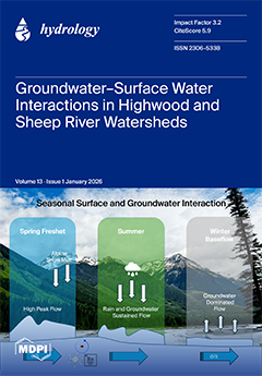
This study investigates seasonal interactions between groundwater and surface water in the Highwood and Sheep River watersheds of southern Alberta. Using hydrogeological mapping and isotopic tracers, we reveal how snowmelt, rainfall, and groundwater sustain streamflow across alpine and non-alpine regions. Spring freshet produces high peak flows driven by snowmelt, summer flows are maintained by rain and shallow groundwater, and winter baseflow is dominated by groundwater discharge. These findings highlight the critical role of alpine aquifers in year-round water supply and inform adaptive water management—timing storage, safeguarding recharge, and planning for earlier snowmelt, more intense rainfall, and longer low-flow periods under climate change. View this paper
  • Issues are regarded as officially published after their release is announced to the table of contents alert mailing list.
  • You may sign up for e-mail alerts to receive table of contents of newly released issues.
  • PDF is the official format for papers published in both, html and pdf forms. To view the papers in pdf format, click on the "PDF Full-text" link, and use the free Adobe Reader to open them.
Order results
Result details
Section
Select all
Export citation of selected articles as:
17 pages, 5601 KB  
Article
Spatiotemporal Variation in Land Use/Land Cover and Its Driving Causes in a Semiarid Watershed, Northeastern China
by Jian Li, Weizhi Li, Haoyue Gao, Hanxiao Liu and Tianling Qin
Hydrology 2026, 13(1), 42; https://doi.org/10.3390/hydrology13010042 - 22 Jan 2026
Viewed by 160
Abstract
The West Liaohe River Basin, a core arid region in Northeast China, faces a significant evaporation–precipitation imbalance and exhibits fragmented land systems, epitomized by the Horqin Sandy Land. Integrating three decades of land use/land cover (LULC) data with meteorological, ecological, and socioeconomic variables, [...] Read more.
The West Liaohe River Basin, a core arid region in Northeast China, faces a significant evaporation–precipitation imbalance and exhibits fragmented land systems, epitomized by the Horqin Sandy Land. Integrating three decades of land use/land cover (LULC) data with meteorological, ecological, and socioeconomic variables, we employed obstacle diagnosis and structural equation modeling (SEM) to elucidate the spatiotemporal dynamics and drivers of LULC transformations. The results demonstrate the following: (1) Land use exhibited a spatially heterogeneous pattern, with forests, shrubs, and grasslands predominantly concentrated in the northwest and southwest. (2) Vegetation coverage significantly increased from 53.15% in 1990 to 61.32% in 2020, whereas cropland and sandy land areas declined. While the overall basin landscape underwent a marked increase in fragmentation. (3) Human activities were the dominant contributor of LULC changes, particularly for cropland conversion, with key determinants such as population and GDP showing negative path coefficients of −0.59 and −0.77, respectively. Climate change was a secondary contributor, with precipitation exerting a strong positive path coefficient (0.63) that was particularly pronounced during the conversion of grassland to forest. These findings offer a scientific basis for land management, ecological restoration strategies, and water resource utilization in the basin. Full article
(This article belongs to the Section Hydrology–Climate Interactions)
Show Figures

Figure 1

27 pages, 9542 KB  
Article
Spatio-Temporal Evaluation of Hydrological Pattern Changes Under Climatic and Anthropogenic Stress in an Endorheic Basin: Coupled SWAT-MODFLOW Analysis of the Lake Cuitzeo Basin
by Alejandra Correa-González, Joel Hernández-Bedolla, Mario Alberto Hernández-Hernández, Sonia Tatiana Sánchez-Quispe, Marco Antonio Martínez-Cinco and Constantino Domínguez Sánchez
Hydrology 2026, 13(1), 41; https://doi.org/10.3390/hydrology13010041 - 21 Jan 2026
Viewed by 145
Abstract
In recent years, human activities have impacted surface water and groundwater and their interactions with natural water bodies. Lake Cuitzeo is one of Mexico’s most important water bodies but has significantly reduced its flooded area in recent years. Previous studies did not explicitly [...] Read more.
In recent years, human activities have impacted surface water and groundwater and their interactions with natural water bodies. Lake Cuitzeo is one of Mexico’s most important water bodies but has significantly reduced its flooded area in recent years. Previous studies did not explicitly evaluate the combined effects of hydrological variables on lake dynamics, limiting the understanding of how basin-scale processes influence lake-level. The objective of this study is to evaluate the change in spatio-temporal patterns of hydrological variables under climatic and anthropogenic stress in the Lake Cuitzeo endorheic basin. The proposed methodology uses the SWAT model to analyze at the basin scale, land use and land cover changes, and trends in precipitation and their effect on hydrological processes. Consequently, groundwater flow interactions were assessed for the first time for the Cuitzeo Lake Basin using an automatically coupled SWAT-MODFLOW (v3, 2019), despite limited observational data. A statistically significant change in mean precipitation was detected beginning in 2015, with a decrease of 10.22% compared to the 1973–2014 mean. Land use and land cover changes between 1997 and 2013 resulted in a 26.20% increase in surface runoff. In contrast, estimated evapotranspiration decreased by 1.77%, potentially associated with the reduction in forest cover. As a combined effect of decreased precipitation and land use and land cover change, groundwater percolation declined by 6.34%. Overall, the combined effects of climatic variables and anthropogenic activities have altered lake–aquifer interaction. Full article
Show Figures

Figure 1

21 pages, 2905 KB  
Article
Laboratory-Scale Evaluation of an Electrochemical Barrier System for Targeted Removal of Vinyl Chloride and Trichloroethylene from Groundwater
by Nataša Duduković, Lea Plavšin, Kristiana Zrnić Tenodi, Malcolm Watson, Marijana Kragulj Isakovski, Božo Dalmacija and Jasmina Agbaba
Hydrology 2026, 13(1), 40; https://doi.org/10.3390/hydrology13010040 - 20 Jan 2026
Viewed by 177
Abstract
Chlorinated solvents such as vinyl chloride (VC) and trichloroethylene (TCE) represent a persistent threat to groundwater-derived drinking-water supplies, including riverbank filtration well fields in alluvial aquifers. This work presents a laboratory-scale evaluation of an electrochemical barrier concept for targeted VC and TCE removal [...] Read more.
Chlorinated solvents such as vinyl chloride (VC) and trichloroethylene (TCE) represent a persistent threat to groundwater-derived drinking-water supplies, including riverbank filtration well fields in alluvial aquifers. This work presents a laboratory-scale evaluation of an electrochemical barrier concept for targeted VC and TCE removal performed using synthetic groundwater representative of a riverbank filtration setting in the Danube River basin. Experiments were conducted in a covered batch reactor equipped with Ti/IrO2–RuO2 mixed-metal-oxide anodes and Ti cathodes, systematically varying current intensity (10–60 mA), treatment time (0–60 min), active anode surface area (12–48 cm2), and inter-electrode distance (0.5–2.5 cm). At 60 mA, VC and TCE removals of 97% and 95%, respectively, were achieved within 20 min, while prolonged treatment to 60 min increased removal to about 99% for VC and 98.5% for TCE. Multivariate analysis (PCA) and correlation assessment identified applied current as the dominant control parameter, particularly for TCE removal, whereas electrode configuration and spacing played secondary roles within the investigated range. For the most cost-effective treatments meeting Serbian drinking-water criteria, estimated electricity costs were 0.39 €/m3 for VC and 0.10 €/m3 for TCE. Overall, the results demonstrate the technical feasibility and promising cost-effectiveness of electrochemical barriers as a proactive measure to protect riverbank filtration systems from future VC and TCE contamination n urban environments, while highlighting the need for follow-up studies on by-product formation and long-term performance. Full article
(This article belongs to the Section Water Resources and Risk Management)
Show Figures

Graphical abstract

20 pages, 4096 KB  
Article
Sustainable Hydrokinetic Energy System for Smart Home Applications
by Julio Jose Caparros Mancera, Antonio García-Chica, Rosa Maria Chica, Cesar Antonio Rodriguez Gonzalez and Angel Mariano Rodriguez Perez
Hydrology 2026, 13(1), 39; https://doi.org/10.3390/hydrology13010039 - 20 Jan 2026
Viewed by 198
Abstract
The exploitation of hydrokinetic resources represents a sustainable and efficient alternative for renewable energy generation. This study presents the design and real-world implementation of a compact hydrokinetic system capable of converting rainwater runoff into electricity within smart homes. Unlike conventional large-scale hydrokinetic technologies, [...] Read more.
The exploitation of hydrokinetic resources represents a sustainable and efficient alternative for renewable energy generation. This study presents the design and real-world implementation of a compact hydrokinetic system capable of converting rainwater runoff into electricity within smart homes. Unlike conventional large-scale hydrokinetic technologies, this system was specifically engineered for intermittent, low-flow conditions typical of residential rainwater collection networks. The turbine was manufactured using 3D-printed biodegradable materials to promote environmental sustainability and facilitate rapid prototyping. Through CFD simulations and laboratory testing, the system’s hydraulic behaviour and energy conversion efficiency were validated across different flow scenarios. The complete system, consisting of four turbines rated at 120 W each, was integrated into a real smart home without structural modifications. From an academic perspective, this study contributes a quantitatively validated hybrid hydrokinetic–low-head framework for residential rainwater energy recovery, addressing intermittent and low-flow urban conditions insufficiently explored in existing literature. Field tests demonstrated that the hydrokinetic system provides complementary energy during rainfall events, generating up to 6000 Wh per day and enhancing household energy resilience, particularly during periods of low solar availability. The results confirm the technical feasibility, sustainability, and practical viability of decentralized hydrokinetic energy generation for residential applications. Full article
Show Figures

Figure 1

22 pages, 3994 KB  
Article
Study on Temporal Convolutional Network Rainfall Prediction Model and Its Interpretability Guided by Physical Mechanisms
by Dongfang Ma, Yunliang Wen, Chongxu Zhao and Chunjin Zhang
Hydrology 2026, 13(1), 38; https://doi.org/10.3390/hydrology13010038 - 19 Jan 2026
Viewed by 186
Abstract
Rainfall, as the main driving force of natural disasters such as floods and droughts, has strong non-linear and abrupt characteristics, which makes it difficult to predict. As extreme weather events occur frequently in the Yellow River Basin, it is especially critical to reveal [...] Read more.
Rainfall, as the main driving force of natural disasters such as floods and droughts, has strong non-linear and abrupt characteristics, which makes it difficult to predict. As extreme weather events occur frequently in the Yellow River Basin, it is especially critical to reveal the physical mechanism of rainfall in the basin and integrate monthly scale meteorological data to achieve monthly rainfall prediction. In this paper, we propose a rainfall prediction model coupled with a physical mechanism and a temporal convolutional network (TCN) to achieve the prediction of monthly rainfall in the basin, aiming to reveal the physical mechanism between rainfall factors in the basin based on the transfer entropy and the multidimensional Copula function and based on the physical mechanism which is embedded into the TCN to construct a dual-driven prediction model with both physical knowledge and data, while the SHAP is used to analyze the interpretability of the prediction model. The results are as follows: (1) Temperature, relative humidity, and evaporation are key characteristic factors driving rainfall. (2) The physical mechanism features between temperature, relative humidity, and evaporation can be described by the three-dimensional Gumbel–Hougaard Copula function, with a more concentrated data distribution of their joint distribution probability. (3) The PHY-TCN model can accurately fit the extremes of the rainfall series, improving the model accuracy in the training set by 3.82%, 1.39%, and 9.82% compared to TCN, CNN, and LSTM, respectively, and in the test set by 6.04%, 2.55%, and 8.91%, respectively. (4) Embedding physical mechanisms enhances the contribution of individual feature variables in the PHY-TCN model and increases the persuasiveness of the model. This study provides a new research framework for rainfall prediction in the YRB and analyzes the physical relationship between the input data and output results of the deep learning model. It has important practical significance and strategic value for guiding the optimal scheduling of water resources, improving the risk management level of the basin, and promoting the ecological protection and high-quality development of the YRB. Full article
(This article belongs to the Special Issue Global Rainfall-Runoff Modelling)
Show Figures

Figure 1

20 pages, 6325 KB  
Article
A Rapid Prediction Model of Rainstorm Flood Targeting Power Grid Facilities
by Shuai Wang, Lei Shi, Xiaoli Hao, Xiaohua Ren, Qing Liu, Hongping Zhang and Mei Xu
Hydrology 2026, 13(1), 37; https://doi.org/10.3390/hydrology13010037 - 19 Jan 2026
Viewed by 162
Abstract
Rainstorm floods constitute one of the major natural hazards threatening the safe and stable operation of power grid facilities. Constructing a rapid and accurate prediction model is of great significance in order to enhance the disaster prevention capacity of the power grid. This [...] Read more.
Rainstorm floods constitute one of the major natural hazards threatening the safe and stable operation of power grid facilities. Constructing a rapid and accurate prediction model is of great significance in order to enhance the disaster prevention capacity of the power grid. This study proposes a rapid prediction model for urban rainstorm flood targeting power grid facilities based on deep learning. The model utilizes computational results of high-precision mechanism models as data-driven input and adopts a dual-branch prediction architecture of space and time: the spatial prediction module employs a multi-layer perceptron (MLP), and the temporal prediction module integrates convolutional neural network (CNN), long short-term memory network (LSTM), and attention mechanism (ATT). The constructed water dynamics model of the right bank of Liangshui River in Fengtai District of Beijing has been verified to be reliable in the simulation of the July 2023 (“23·7”) extreme rainstorm event in Beijing (the July 2023 event), which provides high-quality training and validation data for the deep learning-based surrogate model (SM model). Compared with traditional high-precision mechanism models, the SM model shows distinctive advantages: the R2 value of the overall inundation water depth prediction of the spatial prediction module reaches 0.9939, and the average absolute error of water depth is 0.013 m; the R2 values of temporal water depth processes prediction at all substations made by the temporal prediction module are all higher than 0.92. Only by inputting rainfall data can the water depth at power grid facilities be output within seconds, providing an effective tool for rapid assessment of flood risks to power grid facilities. In a word, the main contribution of this study lies in the proposal of the SM model driven by the high-precision mechanism model. This model, through a dual-branch module in both space and time, has achieved second-level high-precision prediction from rainfall input to water depth output in scenarios where the power grid is at risk of flooding for the first time, providing an expandable method for real-time simulation of complex physical processes. Full article
Show Figures

Figure 1

20 pages, 9753 KB  
Article
Groundwater Pollution Transport in Plain-Type Landfills: Numerical Simulation of Coupled Impacts of Precipitation and Pumping
by Tengchao Li, Shengyan Zhang, Xiaoming Mao, Yuqin He, Ninghao Wang, Daoyuan Zheng, Henghua Gong and Tianye Wang
Hydrology 2026, 13(1), 36; https://doi.org/10.3390/hydrology13010036 - 17 Jan 2026
Viewed by 234
Abstract
Landfills serve as a primary disposal method for municipal solid waste in China, with over 20,000 operational sites nationwide; however, long-term operations risk leachate leakage and groundwater contamination. Amid intensifying climate change and human activities, understanding contaminant evolution mechanisms in landfills has become [...] Read more.
Landfills serve as a primary disposal method for municipal solid waste in China, with over 20,000 operational sites nationwide; however, long-term operations risk leachate leakage and groundwater contamination. Amid intensifying climate change and human activities, understanding contaminant evolution mechanisms in landfills has become critically urgent. Focusing on a representative plain-based landfill in North China, this study integrated field investigations and groundwater monitoring to establish a monthly coupled groundwater flow–solute transport model (using MODFLOW and MT3DMS codes) based on site-specific hydrogeological boundaries and multi-year monitoring data, analyzing spatiotemporal plume evolution under the coupled impacts of precipitation variability (climate change) and intensive groundwater extraction (human activities), spanning the historical period (2021–2024) and future projections (2025–2040). Historical simulations demonstrated robust model performance with satisfactory calibration against observed water levels and chloride concentrations, revealing that the current contamination plume exhibits a distinct distribution beneath the site. Future projections indicate nonlinear concentration increases: in the plume core zone, concentrations rise with precipitation, whereas at the advancing front, concentrations escalate with extraction intensity. Spatially, high-risk zones (>200 mg/L) emerge earlier under wetter conditions—under the baseline scenario (S0), such zones form by 2033 and exceed site boundaries by 2037. Plume expansion scales positively with extraction intensity, reaching its maximum advancement and coverage under the high-extraction scenario. These findings demonstrate dual drivers—precipitation accelerates contaminant accumulation through enhanced leaching, while groundwater extraction promotes plume expansion via heightened hydraulic gradients. This work elucidates coupled climate–human activity impacts on landfill contamination mechanisms, proposing a transferable numerical modeling framework that provides a quantitative scientific basis for post-closure supervision, risk assessment, and regional groundwater protection strategies, thereby aligning with China’s Standard for Pollution Control on the Landfill Site of Municipal Solid Waste and the Zero-Waste City initiative. Full article
Show Figures

Figure 1

25 pages, 5495 KB  
Article
Coupling Modeling Approaches for the Assessment of Runoff Quality in an Urbanizing Catchment
by Lihoun Teang, Kim N. Irvine, Lloyd H. C. Chua and Muhammad Usman
Hydrology 2026, 13(1), 35; https://doi.org/10.3390/hydrology13010035 - 16 Jan 2026
Viewed by 292
Abstract
The impacts of land use on stormwater runoff quality and Best Management Practices to mitigate these impacts have been investigated since the 1970s, yet challenges remain in providing a modeling approach that concomitantly considers contributions from different land use types. In densely developed [...] Read more.
The impacts of land use on stormwater runoff quality and Best Management Practices to mitigate these impacts have been investigated since the 1970s, yet challenges remain in providing a modeling approach that concomitantly considers contributions from different land use types. In densely developed urban areas, a buildup/washoff approach is often applied, while in rural areas, some type of erosion modeling is employed, as the processes of detachment, entrainment, and transport are fundamentally different. This study presents a coupled modeling approach within PCSWMM, integrating exponential buildup/washoff for impervious surfaces with the Modified Universal Soil Loss Equation (MUSLE) for pervious areas, including construction sites, to characterize water quality in the large mixed urban–rural Sparrovale catchment in Geelong, Australia. The watershed includes an innovative cascading system of 12 online NbS wetlands along one of the main tributaries, Armstrong Creek, to manage runoff quantity and quality, as well as 16 offline NbS wetlands that are tributary to the online system. A total of 78 samples for Total Suspended Solids (TSS), Total Phosphorus (TP), and Total Nitrogen (TN) were collected from six monitoring sites along Armstrong Creek during wet- and dry-weather events between May and July 2024 for model validation. The data were supplemented with six other catchment stormwater quality datasets collected during earlier studies, which provided an understanding of water quality status for the broader Geelong region. Results showed that average nutrient concentrations across all the sites ranged from 0.44 to 2.66 mg/L for TP and 0.69 to 5.7 mg/L for TN, spanning from within to above the ecological threshold ranges for eutrophication risk (TP: 0.042 to 1 mg/L, TN: 0.3 to 1.5 mg/L). In the study catchment, upstream wetlands reduced pollutant levels; however, downstream wetlands that received runoff from agriculture, residential areas, and, importantly, construction sites, showed a substantial increase in sediment and nutrient concentration. Water quality modeling revealed washoff parameters primarily influenced concentrations from established urban neighborhoods, whereas erosion parameters substantially impacted total pollutant loads for the larger system, demonstrating the importance of integrated modeling for capturing pollutant dynamics in heterogeneous, urbanizing catchments. The study results emphasize the need for spatially targeted management strategies to improve stormwater runoff quality and also show the potential for cascading wetlands to be an important element of the Nature-based Solution (NbS) runoff management system. Full article
(This article belongs to the Special Issue Advances in Urban Hydrology and Stormwater Management)
Show Figures

Figure 1

26 pages, 7374 KB  
Article
Anticipated Compound Flooding in Miami-Dade Under Extreme Hydrometeorological Events
by Alan E. Gumbs, Alemayehu Dula Shanko, Abiodun Tosin-Orimolade and Assefa M. Melesse
Hydrology 2026, 13(1), 34; https://doi.org/10.3390/hydrology13010034 - 16 Jan 2026
Viewed by 315
Abstract
Climate change and the resulting projected rise in sea level put densely populated urban communities at risk of river flooding, storm surges, and subsurface flooding. Miami finds itself in an increasingly vulnerable position, as compound inundation seems to be a constant and unavoidable [...] Read more.
Climate change and the resulting projected rise in sea level put densely populated urban communities at risk of river flooding, storm surges, and subsurface flooding. Miami finds itself in an increasingly vulnerable position, as compound inundation seems to be a constant and unavoidable occurrence due to its low elevation and limestone geomorphology. Several recent studies on compound overflows have been conducted in Miami-Dade County. However, in-depth research has yet to be conducted on its economic epicenter. Owing to the lack of resilience to tidal surges and extreme precipitation events, Miami’s infrastructure and the well-being of its population may be at risk of flooding. This study applied HEC-RAS 2D to develop one- and two-dimensional water flow models to understand and estimate Miami’s vulnerability to extreme flood events, such as 50- and 100-year return storms. It used Hurricane Irma as a validation and calibration event for extreme event reproduction. The study also explores novel machine learning metamodels to produce a robust sensitivity analysis for the hydrologic model. This research is expected to provide insights into vulnerability thresholds and inform flood mitigation strategies, particularly in today’s unprecedented and intensified weather events. The study revealed that Miami’s inner bay coastline, particularly the downtown coastline, is severely impacted by extreme hydrometeorological events. Under extreme event circumstances, the 35.4 km2 area of Miami is at risk of flooding, with 38% of the areas classified as having medium to extreme risk by FEMA, indicating severe infrastructural and community vulnerability. Full article
Show Figures

Figure 1

13 pages, 2646 KB  
Article
Rainfall Erosivity Variations and Their Relationship with Sediment Delivery Changes in the Lancang River Basin
by Ximeng Xu
Hydrology 2026, 13(1), 33; https://doi.org/10.3390/hydrology13010033 - 16 Jan 2026
Viewed by 259
Abstract
Rainfall erosivity is a key driver of soil erosion and sediment delivery in the Lancang River Basin, but its spatiotemporal variations and relationship with sediment delivery changes remain unquantified. Based on the daily precipitation data from meteorological stations and the annual sediment delivery [...] Read more.
Rainfall erosivity is a key driver of soil erosion and sediment delivery in the Lancang River Basin, but its spatiotemporal variations and relationship with sediment delivery changes remain unquantified. Based on the daily precipitation data from meteorological stations and the annual sediment delivery data from the Yunjinghong hydrologic station, the spatial and temporal variations in rainfall erosivity and how rainfall erosivity changes contribute to the sediment delivery changes were examined in this study. The results showed that the annual average rainfall erosivity varied from 202.6 to 15,946.6 MJ mm ha−1 h−1 a−1 among stations. The rainfall erosivity increased from the upstream to the downstream as elevation decreased. Basin-wide average rainfall erosivity declined by about ten percent from 1958 to 2019, with a decreasing rate of −6.3 MJ mm ha−1 h−1 a−1 per year. Summer rainfall erosivity accounted for the largest portion of the rainfall erosivity throughout the whole year. The sediment delivery increased from 1963 to 2000 but has sharply decreased since 2001. Double mass curve analysis revealed that rainfall erosivity reduction accounted for 32% of the sediment delivery decrease after 2001, with human activities (vegetation restoration and dam operations) contributing the remaining 68%. Full article
Show Figures

Figure 1

20 pages, 6196 KB  
Article
Subsurface Temperature Distributions Constrain Groundwater Flow in Salar Marginal Environments
by David F. Boutt, Julianna C. Huba, Lee Ann Munk and Kristina L. Butler
Hydrology 2026, 13(1), 32; https://doi.org/10.3390/hydrology13010032 - 15 Jan 2026
Viewed by 191
Abstract
Interactions between surface water and groundwater in arid regions regulate their response to climate and human impacts. In the salar systems of the Altiplano-Puna plateau (Bolivia, Chile, Argentina), understanding how surface waters connect to groundwater is crucial for accurate modeling and assessment. This [...] Read more.
Interactions between surface water and groundwater in arid regions regulate their response to climate and human impacts. In the salar systems of the Altiplano-Puna plateau (Bolivia, Chile, Argentina), understanding how surface waters connect to groundwater is crucial for accurate modeling and assessment. This study introduces new data and analysis using subsurface thermal profiles and modeling to identify flow patterns and possible surface water links. We document, to our knowledge, for the first time in the literature, deep-seated cooling of the subsurface caused by extreme evaporation rates. The subsurface is cooled by 4–5 degrees Celsius below the mean annual air temperature to depths greater than 50 m, even though groundwater inflow waters are elevated by 10 degrees °C due to geothermal heating. Three thermal zones are observed along the southern edge of Salar de Atacama, with temperature dropping from 28 °C to about 12 °C over 2.5 km. A 2D numerical model of groundwater and heat flow was developed to test various hydrological scenarios and understand the factors controlling the thermal regime. Two flow scenarios at the southern margin were examined: a diffuse flow model with uniform flow and flux to the surface and a focused flow model with preferential discharge at a topographic slope break. Results indicate that the focused flow scenario matches thermal data, with warm inflow water discharging into a transition zone between freshwater and brine, cooling through evaporation, re-infiltration, and surface flow, then re-emerging near lagoons at the halite nucleus margin. This research offers valuable insights into the groundwater hydraulics in the Salar de Atacama and can aid in monitoring environmental changes causally linked to lithium mining and upgradient freshwater extraction. Full article
(This article belongs to the Section Surface Waters and Groundwaters)
Show Figures

Figure 1

34 pages, 14353 KB  
Article
Nationwide Prediction of Flood Damage Costs in the Contiguous United States Using ML-Based Models: A Data-Driven Approach
by Khaled M. Adel, Hany G. Radwan and Mohamed M. Morsy
Hydrology 2026, 13(1), 31; https://doi.org/10.3390/hydrology13010031 - 14 Jan 2026
Viewed by 296
Abstract
Flooding remains one of the most disruptive and costly natural hazards worldwide. Conventional approaches for estimating flood damage cost rely on empirical loss curves or historical insurance data, which often lack spatial resolution and predictive robustness. This study develops a data-driven framework for [...] Read more.
Flooding remains one of the most disruptive and costly natural hazards worldwide. Conventional approaches for estimating flood damage cost rely on empirical loss curves or historical insurance data, which often lack spatial resolution and predictive robustness. This study develops a data-driven framework for estimating flood damage costs across the contiguous United States, where comprehensive hydrologic, climatic, and socioeconomic data are available. A database of 17,407 flood events was compiled, incorporating approximately 38 parameters obtained from the National Oceanic and Atmospheric Administration (NOAA), the National Water Model (NWM), the United States Geological Survey (USGS NED), and the U.S. Census Bureau. Data preprocessing addressed missing values and outliers using the interquartile range and Walsh tests, followed by partitioning into training (70%), testing (15%), and validation (15%) subsets. Four modeling configurations were examined to improve predictive accuracy. The optimal hybrid regression–classification framework achieved correlation coefficients of 0.97 (training), 0.77 (testing), and 0.81 (validation) with minimal bias (−5.85, −107.8, and −274.5 USD, respectively). The findings demonstrate the potential of nationwide, event-based predictive approaches to enhance flood-damage cost assessment, providing a practical tool for risk evaluation and resource planning. Full article
Show Figures

Figure 1

28 pages, 9311 KB  
Article
Modeling Reliability Quantification of Water-Level Thresholds for Flood Early Warning
by Shiang-Jen Wu, Hao-Wen Yang, Sheng-Hsueh Yang and Keh-Chia Yeh
Hydrology 2026, 13(1), 30; https://doi.org/10.3390/hydrology13010030 - 14 Jan 2026
Viewed by 199
Abstract
This study proposes a framework, the RA_WLTE_River model, for quantifying the reliability of flood-altering water-level thresholds, considering rainfall and runoff-related uncertainties. The Keelung River in northern Taiwan is selected as the study area, and associated hydrological data from 2008 to 2016 are applied [...] Read more.
This study proposes a framework, the RA_WLTE_River model, for quantifying the reliability of flood-altering water-level thresholds, considering rainfall and runoff-related uncertainties. The Keelung River in northern Taiwan is selected as the study area, and associated hydrological data from 2008 to 2016 are applied in the development and application of the model. According to the results from the model development and demonstration, the average and maximum rainfall intensities, roughness coefficients, and maximum tide depths exhibit a significant contribution to the reliability quantification of the estimated water-level thresholds. In addition, empirically based water-level thresholds can achieve the goal of rainfall-induced flood early warning, with a high likelihood of nearly 0.95. Additionally, the probabilistically based water-level thresholds derived from the described reliability can efficiently ensure consistent flood early warning performance at all control points along the river. Full article
(This article belongs to the Section Statistical Hydrology)
Show Figures

Figure 1

18 pages, 3463 KB  
Article
Numerical Simulation of Typical River Closure Process and Sensitivity Analysis of Influencing Factors
by Lan Ma, Chao Li, Zhanquan Yao and Xuefei Ji
Hydrology 2026, 13(1), 29; https://doi.org/10.3390/hydrology13010029 - 12 Jan 2026
Viewed by 227
Abstract
River ice is a common natural phenomenon in cold regions during winter, and it is also one of the key factors that must be considered in the development and utilization of water resources in these areas. In this paper, based on a two-dimensional [...] Read more.
River ice is a common natural phenomenon in cold regions during winter, and it is also one of the key factors that must be considered in the development and utilization of water resources in these areas. In this paper, based on a two-dimensional hydrodynamic model and ice dynamics model coupled with a linear thermodynamic process, this study simulates and validates the formation, decay, transport, and accumulation of river ice at the Toudaoguai reach of the Yellow River in Inner Mongolia during the winters of 2019–2020 and 2020–2021. The influence of different parameters on backwater level variations caused by ice jams is further investigated using a modified Morris sensitivity analysis method. The results show that (1) the coupled thermal-dynamic model can accurately simulate the formation, transport, and accumulation process of river ice in natural river, as well as the freeze-up patterns and corresponding hydraulic characteristics. (2) Due to the influence of river topography, flow rate, and flow density, the freeze-up form is slightly different in different years, and the low discharge process favor a more stable freeze-up. (3) According to the modified Morris screening method, discharge (Q) and ice concentration (N) are the most sensitive to the change in the backwater water level after the ice jam, and the sensitivity is more than 50%. The next most sensitive factor is the ice-cover roughness (ni), whereas ice porosity (ef) exhibits a negative sensitivity to the water level after ice jam. Thus, this study provides effective tools to reproduce the process of river ice transport and accumulation in the reach of the Yellow River (Inner Mongolia section) and offers technical support and insights for ice-flood prevention and mitigation in this section. Full article
Show Figures

Figure 1

21 pages, 2195 KB  
Article
The Floodport App for Interactive Coastal Flood Risk Training
by Angelos Alamanos, Phoebe Koundouri, Nikolaos Nagkoulis and Olympia Nisiforou
Hydrology 2026, 13(1), 28; https://doi.org/10.3390/hydrology13010028 - 11 Jan 2026
Viewed by 289
Abstract
Coastal flooding can result from multiple interacting drivers and can be a complex, challenging topic for learners to grasp. Interactive learning with apps offers new opportunities for improving comprehension and engagement. We present the Floodport app, an educational interactive tool that puts students [...] Read more.
Coastal flooding can result from multiple interacting drivers and can be a complex, challenging topic for learners to grasp. Interactive learning with apps offers new opportunities for improving comprehension and engagement. We present the Floodport app, an educational interactive tool that puts students in the role of coastal risk analysts exploring how natural hazards threaten port safety. Users have to adjust key parameters, including high tides, storm surges, terrestrial rainfall contribution, sea-level rise, and engineered features such as dock height. These forces, individually or jointly, result in water-level rises that may flood the app’s port. The app supports exploration of mitigation designs for the port. Developed in Excel and Python 3.11.4 and deployed as an R/Shiny application, Floodport was used as a classroom game by 153 students with no prior knowledge on coastal flooding concepts. Pre–post survey statistical analysis showed significant learning gains and positively correlation with willingness to engage further. Floodport was found to be a useful tool for basic introduction to flooding concepts. The results indicate strong pedagogical promise and potential for using the app beyond the classroom, in contexts such as stakeholder engagement and training. Full article
Show Figures

Figure 1

24 pages, 3803 KB  
Article
Surface Runoff Responses to Forest Thinning in Semi-Arid Oak–Pine Micro-Catchments of Northern Mexico
by Gabriel Sosa-Pérez, Argelia E. Rascón-Ramos, David E. Hermosillo-Rojas, Alfredo Pinedo Alvarez, Eduardo Santellano-Estrada, Raúl Corrales-Lerma, Sandra Rodríguez-Piñeros and Martín Martínez-Salvador
Hydrology 2026, 13(1), 27; https://doi.org/10.3390/hydrology13010027 - 9 Jan 2026
Viewed by 483
Abstract
Hydrological behavior plays a critical role in seasonally dry forest ecosystems, as it underpins water availability for multiple productive activities, including forestry, agriculture, grazing, and urban supply. This study evaluated the hydrological effects of thinning treatments in a semi-arid oak–pine forest of Chihuahua, [...] Read more.
Hydrological behavior plays a critical role in seasonally dry forest ecosystems, as it underpins water availability for multiple productive activities, including forestry, agriculture, grazing, and urban supply. This study evaluated the hydrological effects of thinning treatments in a semi-arid oak–pine forest of Chihuahua, Mexico, using a Before–After–Control–Impact (BACI) design. Three Micro-catchments (MC) with initially comparable tree density and canopy cover were monitored during the rainy seasons of 2018 (pre-thinning) and 2019 (post-thinning). Thinning treatments were applied at 20% and 60% canopy cover in two MC, while a third remained unthinned as a 100% control. Precipitation and surface runoff were recorded at the event scale, and data were analyzed using Weibull probability models with a log link to capture the frequency and magnitude of runoff events. Precipitation patterns were broadly comparable across years, although 2018 included an extreme storm event (59 mm). In contrast, runoff volumes in 2019 were lower despite marginally higher seasonal rainfall, reflecting the absence of large storms. Statistical modeling indicated that for each additional millimeter of precipitation, mean runoff increased by approximately 12%, although thinning significantly altered baseline conditions. Relative to 2018, mean runoff ratios were 0.087 in the 100% canopy catchment, 0.296 in the 60% treatment, and 0.348 in the 20% treatment, suggesting that reduced canopy cover retained proportionally more runoff than the control. BACI contrasts confirmed that thinned catchments maintained higher proportions of runoff than the unthinned control, although statistical significance was marginal for the 20% canopy treatment. Overall, the study provides ecohydrological insights relevant to the management of semi-arid forest ecosystems. Full article
Show Figures

Figure 1

27 pages, 20617 KB  
Article
Evaluation of a Computational Simulation Approach Combining GIS, 2D Hydraulic Software, and Deep Learning Technique for River Flood Extent Mapping
by Nikolaos Xafoulis, Evangelia Farsirotou, Spyridon Kotsopoulos and Aris Psilovikos
Hydrology 2026, 13(1), 26; https://doi.org/10.3390/hydrology13010026 - 9 Jan 2026
Viewed by 382
Abstract
Floods are among the most catastrophic natural disasters, causing severe impact on human lives and ecosystems. The proposed methodology integrates Geographic Information Systems, 2D hydraulic modeling, and deep learning techniques to develop a computational simulation approach for flood extent prediction and was implemented [...] Read more.
Floods are among the most catastrophic natural disasters, causing severe impact on human lives and ecosystems. The proposed methodology integrates Geographic Information Systems, 2D hydraulic modeling, and deep learning techniques to develop a computational simulation approach for flood extent prediction and was implemented in the Enipeas River basin, located within the Thessalia River Basin District, Greece. Hydrological analysis was performed using the HEC-HMS software (version 4.12), while hydraulic simulations were conducted with HEC-RAS 2D. The hydraulic modeling produced synthetic flood scenarios for a 1000-year return period, generating spatially distributed outputs of flood extents. The deep learning algorithm was based on a U-Net (CNN) architecture. The model was trained using multi-channel raster tiles, including open access geospatial data such as Digital Elevation Model, slope, flow direction, stream centerline, land use, and simulated flood extents. Model validation was carried out in two independent domains (TS1 and TS2) located within the same river basin. Model outputs are adequately compared with both 2D hydraulic simulations and official Flood Risk Management Plan maps, and the comparison indicates close spatial and quantitative agreement, with flood extent area differences below 8%. Based on the results, the proposed methodology presents a potential and efficient tool for rapid flood risk mapping. Full article
Show Figures

Figure 1

28 pages, 8219 KB  
Article
Rainfall–Groundwater Correlations Using Statistical and Spectral Analyses: A Case Study on the Coastal Plain of Al-Hsain Basin, Syria
by Mahmoud Ahmad, Katalin Bene and Richard Ray
Hydrology 2026, 13(1), 25; https://doi.org/10.3390/hydrology13010025 - 8 Jan 2026
Viewed by 566
Abstract
Climate change and irregular precipitation patterns have increasingly threatened groundwater sustainability in semi-arid regions like the Eastern Mediterranean. Specifically, in coastal Syria, the lack of quantitative understanding regarding aquifer recharge mechanisms hinders effective water resource management. To address this, this study investigates the [...] Read more.
Climate change and irregular precipitation patterns have increasingly threatened groundwater sustainability in semi-arid regions like the Eastern Mediterranean. Specifically, in coastal Syria, the lack of quantitative understanding regarding aquifer recharge mechanisms hinders effective water resource management. To address this, this study investigates the dynamic relationship between rainfall and groundwater levels in the Al-Hsain Basin coastal plain using 48 months of monitoring data (2020–2024) from 35 wells. We employed a unified analytical framework combining statistical methods (correlation, regression) with advanced time–frequency techniques (Wavelet Coherence) to capture recharge behavior across diverse Quaternary, Neogene, and Cretaceous strata. The results indicate strong climatic control on groundwater dynamics, particularly in shallow Quaternary wells, which exhibit rapid recharge responses (lag < 1 month). In contrast, deeper aquifers showed delayed and buffered responses. A dual-variable model incorporating temperature significantly improved prediction accuracy (R2 = 0.97), highlighting the role of evapotranspiration. These findings provide a transferable diagnostic framework for identifying recharge zones and supporting adaptive groundwater governance in data-scarce semi-arid environments. Full article
Show Figures

Figure 1

12 pages, 1760 KB  
Article
Mechanisms of Multi-Path Runoff Leakage Induced by Cracks at the Rock–Soil Interface on Bedrock-Exposed Slopes in Karst Critical Zones
by Xingya Chen, Xudong Peng, Longpei Cen, Wenping Meng, Quanhou Dai and Yanyi Huang
Hydrology 2026, 13(1), 24; https://doi.org/10.3390/hydrology13010024 - 8 Jan 2026
Viewed by 472
Abstract
As exposed bedrocks commonly interface with the soil directly, lacking a transition layer, cracks at rock–soil interface cracks (RSI-Cracks), are well-developed, particularly following wet–dry alternation in karst critical zones. However, inadequate understanding of the influence of RSI-Cracks on multi-path runoff generation around bedrocks [...] Read more.
As exposed bedrocks commonly interface with the soil directly, lacking a transition layer, cracks at rock–soil interface cracks (RSI-Cracks), are well-developed, particularly following wet–dry alternation in karst critical zones. However, inadequate understanding of the influence of RSI-Cracks on multi-path runoff generation around bedrocks has hindered an in-depth comprehension of subsurface-dominated hydrological processes in karst areas. To address this gap, we developed micro-slope models replicating rock–soil interfacial configurations by building upon field investigations. Two conditions, namely, the presence and absence of RSI-Cracks, were incorporated, with rain intensity and rock surface inclination as experimental conditions. Our results indicate that RSI-Cracks significantly alter the runoff output (p < 0.05), exacerbating subsurface water leakage. Compared with that on slopes without RSI-Cracks, the proportion of surface runoff on slopes with RSI-Cracks is reduced, with a reduction range of 4 to 46%. Conversely, RSI-Cracks promote an increase in the proportion of outflow at the rock–soil interface (RSI flow), with an increase range of 7 to 38%. This is an important reason for the aggravation of subsurface water leakage through RSI-Cracks. However, there is no significant change in the water loss caused by internal soil seepage on slopes with or without RSI-Cracks. These findings provide novel insights into underground water loss, with valuable implications for the construction and improvement of hydrological models in karst areas. Full article
(This article belongs to the Special Issue The Influence of Landscape Disturbance on Catchment Processes)
Show Figures

Figure 1

21 pages, 4727 KB  
Article
Effects of Groundwater Flux on Denitrification in a Steep Coastal Agricultural Island in Western Japan Using Push–Pull Tests
by Kelly Tiku Tarh, Shin-ichi Onodera, Mitsuyo Saito, Sharon Bih Kimbi and Miho Awamura
Hydrology 2026, 13(1), 23; https://doi.org/10.3390/hydrology13010023 - 7 Jan 2026
Viewed by 704
Abstract
This study investigated the influence of groundwater flux and temperature on denitrification in a steep coastal agricultural Island in western Japan. Push–pull tests (PPTs) were conducted at depths of 3 m, 15 m, and 30 m, during winter, spring, and summer to assess [...] Read more.
This study investigated the influence of groundwater flux and temperature on denitrification in a steep coastal agricultural Island in western Japan. Push–pull tests (PPTs) were conducted at depths of 3 m, 15 m, and 30 m, during winter, spring, and summer to assess denitrification under varying hydrogeological and seasonal conditions. The 3 m layer is silty loam, 15 m is granitic weathered soil, and 30 m is granitic weathered rock, each with distinct hydraulic conductivities and fluxes. The objectives were to assess denitrification rates and fluxes, assess depth- and season-related variability, and determine the relative roles of hydraulic flux and temperature on denitrification. Denitrification was higher at shallow (3 m) and deep (30 m) boreholes during low-flux periods, while low at the intermediate depth (15 m) where fluxes were highest. Temperature variation had weak correlations compared to hydraulic flux, which showed a strong inverse correlation with denitrification. These findings demonstrate that residence time, controlled by groundwater flux, is the dominant factor influencing nitrate attenuation in this steep coastal aquifer. The PPTs results indicate that denitrification rates derived from PPTs decrease under higher hydraulic fluxes, as these conditions promote more oxic conditions. The study highlights the potential for natural denitrification to mitigate nitrate contamination during low-flux periods, providing insights for sustainable groundwater management in agricultural island environments. Full article
Show Figures

Graphical abstract

30 pages, 6524 KB  
Article
Modeling and Assessment of Salinity Reduction Strategies in the Jarahi River, Iran
by Javad Ahadiyan, Narges Yarahamdi, Asghar Akbari, Seyed Mohsen Sajjadi, Hossein Azizi Nadian and Farhad Bahmanpouri
Hydrology 2026, 13(1), 22; https://doi.org/10.3390/hydrology13010022 - 6 Jan 2026
Viewed by 286
Abstract
This study investigates the spatial and temporal variations in salinity in the Jarahi River and its traditional channels using field measurements and numerical simulations. The primary objective is to assess the effectiveness of different management strategies for salinity reduction under minimum-discharge conditions. Salinity [...] Read more.
This study investigates the spatial and temporal variations in salinity in the Jarahi River and its traditional channels using field measurements and numerical simulations. The primary objective is to assess the effectiveness of different management strategies for salinity reduction under minimum-discharge conditions. Salinity dynamics were analyzed through electrical conductivity (EC) measurements collected over a one-year period and simulated using the MIKE 11 hydrodynamic model. Model performance was evaluated by comparing simulated and observed EC values at key monitoring stations. The results indicate that maximum salinity levels occur during March and April in both the main river and traditional channels, while the highest temporal variability in EC was observed in October. The comparison between observed and simulated data showed a relative error of less than 10%, confirming the reliability of the model simulations. Four management scenarios were evaluated: (1) preventing inflow from the Motbeg drainage, (2) blocking non-centralized drainage inputs, (3) removing all inlet drains, and (4) increasing discharge releases from the Ramshir Dam. The first and third scenarios led to the highest salinity reductions, reaching up to 39% (approximately 1266 µS/cm) in the Gorgor channel, while reductions of up to 53% were observed in traditional streams such as Mansuri and Omal-Sakher under the third scenario. Increasing dam releases resulted in a maximum reduction of 23% (724 µS/cm) at the Gorgor station. Finally, the proposed management strategies significantly reduced salinity levels along the river system, particularly at the entrance of the Jahangiri traditional stream, providing practical insights for salinity control and river basin management. Full article
(This article belongs to the Section Hydrological and Hydrodynamic Processes and Modelling)
Show Figures

Figure 1

17 pages, 2944 KB  
Article
Prolonged Dry Periods Associated with Riparian Vegetation Growth and Channel Simplification
by Michael Nones and Yiwei Guo
Hydrology 2026, 13(1), 21; https://doi.org/10.3390/hydrology13010021 - 6 Jan 2026
Viewed by 244
Abstract
Climate change is impacting rivers worldwide, with a reduction in normal flow conditions in temperate regions like Poland. Such changes might have a significant influence on riparian vegetation and channel planform dynamics. To better understand how these changes impact the river morphology, this [...] Read more.
Climate change is impacting rivers worldwide, with a reduction in normal flow conditions in temperate regions like Poland. Such changes might have a significant influence on riparian vegetation and channel planform dynamics. To better understand how these changes impact the river morphology, this research focuses on a 250 km-long reach of the Polish Vistula River and investigates variations of monthly maximum discharges and vegetation conditions over the period 1984–2023 by means of Landsat satellite images. These satellite data were handled via Google Earth Engine, looking at a common index such as the Normalized Difference Vegetation Index, considered as a proxy of vegetation coverage variations. Results point out an increase in the median NDVI over the study area from 0.2 in 1984 to 0.3 in 2023, connected with a reduction of monthly discharge from around 920 m3/s to 880 m3/s. This suggests that changes in flow discharge are associated with a process of riparian vegetation growth, leading to a reduction of planform and bars dynamics and closure of secondary channels (i.e., oversimplification). This is particularly evident over the last couple of decades, during which water availability has decreased significantly, as more humid years in the middle of the study period are now no longer existing, with an observed decrease in the maximum monthly discharge during the last 20 years, likely connected with a more severe impact of climate change. This reduction in flooding events allows more time for vegetation to establish on river bars and banks, eventually creating new islands and causing the observed oversimplification of the active channel. In summary, using the Vistula River as an exemplary case study, this research suggests that prolonged dry periods, more common in recent decades due to climate change, might impact large rivers located in temperate climates, favouring the development of vegetation on exposed sandbars, eventually resulting in a less dynamic active channel. Full article
Show Figures

Figure 1

30 pages, 9248 KB  
Article
Groundwater and Surface Water Interactions in the Highwood River and Sheep River Watersheds: An Integrated Alpine and Non-Alpine Assessment
by Aprami Jaggi, Dayal Wijayarathne, Michael Wendlandt, Tiago A. Morais, Tatiana Sirbu, Andrew Underwood, Paul Eby and John Gibson
Hydrology 2026, 13(1), 20; https://doi.org/10.3390/hydrology13010020 - 6 Jan 2026
Viewed by 623
Abstract
Groundwater–surface water interactions were investigated in the Highwood River (3952 km2) and Sheep River watersheds (1568 km2), originating in the Rocky Mountains headwaters of the South Saskatchewan River (Alberta, Canada), to improve understanding of hydrological processes that potentially influence [...] Read more.
Groundwater–surface water interactions were investigated in the Highwood River (3952 km2) and Sheep River watersheds (1568 km2), originating in the Rocky Mountains headwaters of the South Saskatchewan River (Alberta, Canada), to improve understanding of hydrological processes that potentially influence water use and vulnerability to climatic change in representative, alpine-fed mixed-use watersheds. Similar to adjacent regions of the Bow, Red Deer and Oldman watersheds, the upper reaches of these watersheds are sparsely populated with significant seasonal glacier and snowmelt influence, while the lower watersheds are currently under increasing water supply pressure from competing agricultural–municipal interests, with notable risk of flooding during high-flow events and drought during the growing season. Investigations included mapping of hydrologic and hydrogeologic controls (aquifers, buried channels, colluvial deposits, etc.,) and synoptic geochemical and isotopic surveys (δ2H, δ18O, δ13C-DIC, 222Rn) to characterize evolution in water type and seasonal progression in streamflow sources and underlying mechanisms. Our findings confirm seasonal progression in streamflow water sources, characterized by a pronounced snowmelt-dominated spring freshet, but with a sustained recession fed by colluvial, moraine, fluvial, and fractured bedrock sources. Seasonal isotopic variations establish that shallow groundwater sources are actively maintained throughout the spring freshet, often accounting for a dominant portion of streamflow, which indicates active displacement of groundwater storage by snowmelt recharge during spring melt. The contrast in the proportion of alpine contributions in each watershed suggests these systems may respond very differently to climate change, which needs to be carefully considered in developing sustainable water-use strategies for each watershed. Full article
(This article belongs to the Section Surface Waters and Groundwaters)
Show Figures

Figure 1

24 pages, 13069 KB  
Article
China’s Seasonal Precipitation: Quantitative Attribution of Ocean-Atmosphere Teleconnections and Near-Surface Forcing
by Chang Lu, Long Ma, Bolin Sun, Xing Huang and Tingxi Liu
Hydrology 2026, 13(1), 19; https://doi.org/10.3390/hydrology13010019 - 4 Jan 2026
Viewed by 681
Abstract
Under concurrent global warming and multi-scale climate anomalies, regional precipitation has become more uneven and less stable, and extreme events occur more frequently, amplifying water scarcity and ecological risk. Focusing on mainland China, we analyze nearly 70 years of monthly station precipitation records [...] Read more.
Under concurrent global warming and multi-scale climate anomalies, regional precipitation has become more uneven and less stable, and extreme events occur more frequently, amplifying water scarcity and ecological risk. Focusing on mainland China, we analyze nearly 70 years of monthly station precipitation records together with eight climate drivers—the Pacific Decadal Oscillation (PDO), Atlantic Multidecadal Oscillation (AMO), Multivariate ENSO Index (MEI), Arctic Oscillation (AO), surface air pressure (AP), wind speed (WS), relative humidity (RH), and surface solar radiation (SR)—and precipitation outputs from eight CMIP6 models. Using wavelet analysis and partial redundancy analysis, we systematically evaluate the qualitative relationships between climate drivers and precipitation and quantify the contribution of each driver. The results show that seasonal precipitation decreases stepwise from the southeast toward the northwest, and that stability is markedly lower in the northern arid and semi-arid regions than in the humid south, with widespread declines near the boundary between the second and third topographic steps of China. During the cold season, and in the northern arid and semi-arid zones and along the margins of the Tibetan Plateau, precipitation varies mainly with interdecadal swings of North Atlantic sea surface temperature and with the strength of polar and midlatitude circulation, and it is further amplified by variability in near-surface winds; the combined contribution reaches about 32% across the Northeast Plain, the Junggar Basin, and areas north of the Loess Plateau. During the warm season, and in the eastern and southern monsoon regions, precipitation is modulated primarily by tropical Pacific sea surface temperature and convection anomalies and by related changes in the position and strength of the subtropical high, moisture transport pathways, and relative humidity; the combined contribution is about 22% south of the Yangtze River and in adjacent areas. Our findings reveal the spatiotemporal variability of precipitation in China and its responses to multiple climate drivers and their relative contributions, providing a quantitative basis for water allocation and disaster risk management under climate change. Full article
Show Figures

Figure 1

30 pages, 9320 KB  
Article
Flood Hazard Assessment Under Subsidence-Influenced Terrain Using Deformation-Adjusted DEM in an Oil and Gas Field
by Mohammed Al Sulaimani, Rifaat Abdalla, Mohammed El-Diasty, Amani Al Abri, Mohamed A. K. El-Ghali and Ahmed Tabook
Hydrology 2026, 13(1), 18; https://doi.org/10.3390/hydrology13010018 - 4 Jan 2026
Viewed by 339
Abstract
Flood hazards in arid oil-producing regions result from both natural hydrological processes and terrain changes due to land subsidence. In the Yibal field in northern Oman, long-term hydrocarbon extraction has caused measurable ground deformation, altering surface gradients and drainage patterns. This study presents [...] Read more.
Flood hazards in arid oil-producing regions result from both natural hydrological processes and terrain changes due to land subsidence. In the Yibal field in northern Oman, long-term hydrocarbon extraction has caused measurable ground deformation, altering surface gradients and drainage patterns. This study presents a deformation-adjusted flood hazard assessment by integrating a 2013 photogrammetric DEM with a 2023 subsidence-corrected DEM derived from multi-temporal PS-InSAR observations (RADARSAT-2 and TerraSAR-X). Key hydrological indicators—including slope, drainage networks, Height Above Nearest Drainage (HAND), floodplain depth, Curve Number, and extreme precipitation from the wettest monthly rainfall in a 10-year archive—were recalculated for both years. Flood hazard maps for 2013 and 2023 were generated using an AHP-based multi-criteria framework across five hydrologically motivated scenarios. Results indicate that while the total area of high- and very-high-hazard zones changed only slightly in most scenarios (within ±6%), these zones shifted into subsidence-affected depressions, reflecting deformation-driven redistribution of flood-prone areas. Low-hazard zones grew most significantly, especially in Scenarios S2–S4, with increases of 160–320% compared to 2013, while moderate-hazard areas showed smaller but consistent growth. Floodplain-dominated conditions (S5) produced the most pronounced nonlinear response, with a substantial increase in very low hazard and localized concentration of very high hazard in areas of deepest subsidence. Geomorphic analysis using the Geomorphic Flood Index (GFI) shows deepening of flow pathways and expansion of geomorphic depressions between 2013 and 2023, supporting the modeled redistribution of hazards. These findings demonstrate that even moderate subsidence can significantly alter hydrological susceptibility and underscore the importance of incorporating deformation-adjusted terrain modeling into flood hazard assessments in petroleum fields and other subsidence-prone areas. Full article
Show Figures

Figure 1

34 pages, 11413 KB  
Article
Hydrodynamic-Ecological Synergistic Effects of Interleaved Jetties: A CFD Study Based on a 180° Bend
by Dandan Liu, Suiju Lv and Chunguang Li
Hydrology 2026, 13(1), 17; https://doi.org/10.3390/hydrology13010017 - 2 Jan 2026
Viewed by 631
Abstract
Under the dual pressures of global climate change and anthropogenic activities, enhancing the ecological functions of hydraulic structures has become a critical direction for sustainable watershed management. While traditional spur dike designs primarily focus on bank protection and flood control, current demands require [...] Read more.
Under the dual pressures of global climate change and anthropogenic activities, enhancing the ecological functions of hydraulic structures has become a critical direction for sustainable watershed management. While traditional spur dike designs primarily focus on bank protection and flood control, current demands require additional consideration of river ecosystem restoration. Numerical simulations were performed using the RNG k-ε turbulence model to solve the three-dimensional Reynolds-averaged Navier–Stokes equations, a formulation that enhances prediction accuracy for complex flows in curved channels, including separation and reattachment. Following a grid independence study and the application of standard wall functions for near-wall treatment, a comparative analysis was conducted to examine the flow characteristics and ecological effects within a 180° channel bend under three configurations: no spur dikes, a single-side arrangement, and a staggered arrangement of non-submerged, flow-aligned, rectangular thin-walled spur dikes. The results demonstrate that staggered spur dikes significantly reduce the lateral water surface gradient by concentrating the main flow, thereby balancing water levels along the concave and convex banks and suppressing lateral channel migration. Their synergistic flow-contracting effect enhances the kinetic energy of the main flow and generates multi-scale turbulent vortices, which not only increase sediment transport capacity in the main channel but also create diverse habitat conditions. Specifically, the bed shear stress in the central channel region reached 2.3 times the natural level. Flow separation near the dike heads generated a high-velocity zone, elevating velocity and turbulent kinetic energy by factors of 2.3 and 6.8, respectively. This shift promoted bed sediment coarsening and consequently increased scour resistance. In contrast, the low-shear wake zones behind the dikes, with weakened hydrodynamic forces, facilitated fine-sediment deposition and the growth of point bars. Furthermore, this study identifies a critical interface (observed at approximately 60% of the water depth) that serves as a key interface for vertical energy conversion. Below this height, turbulence intensity intermittently increases, whereas above it, energy dissipates markedly. This critical elevation, controlled by both the spur dike configuration and flow conditions, embodies the transition mechanism of kinetic energy from the mean flow to turbulent motions. These findings provide a theoretical basis and engineering reference for optimizing eco-friendly spur dike designs in meandering rivers. Full article
Show Figures

Figure 1

21 pages, 3405 KB  
Article
Spatiotemporal Dynamics and Lagged Hydrological Impacts of Compound Drought and Heatwave Events in the Poyang Lake Basin
by Ningning Li, Yang Yang, Zikang Xing, Yi Zhao, Jianhui Wei, Miaomiao Ma and Xuejun Zhang
Hydrology 2026, 13(1), 16; https://doi.org/10.3390/hydrology13010016 - 30 Dec 2025
Viewed by 449
Abstract
Compound drought and heatwave (CDHW) events pose a rising threat to global water security and ecosystem stability. While their increased frequency under global warming is recognized, their spatiotemporal evolution and subsequent cascading impacts on hydrological processes in monsoonal lake basins remain poorly quantified. [...] Read more.
Compound drought and heatwave (CDHW) events pose a rising threat to global water security and ecosystem stability. While their increased frequency under global warming is recognized, their spatiotemporal evolution and subsequent cascading impacts on hydrological processes in monsoonal lake basins remain poorly quantified. This study investigates the characteristics and hydrological impacts of CDHW in the Poyang Lake Basin, China’s largest freshwater lake, from 1981 to 2016. Using a daily rolling-window approach with the Standardized Precipitation Index (SPI) and Standardized Temperature Index (STI), we identified CDHW events and characterized them with metrics of frequency, severity, and intensity. Event coincidence analysis (ECA) was employed to quantify the trigger relationship between CDHW and subsequent hydrological droughts (streamflow and lake water level). Our results reveal a paradigmatic shift in the CDHW regime post-2000, marked by statistically significant increases in all three metrics and a fundamental alteration in their statistical distributions. ECA demonstrated that intensified CDHW events significantly enhance hydrological drought risk, primarily through a robust and increasing lagged influence at seasonal timescales (peaking at 40–90 days). Decomposition of compound events attributes this protracted impact predominantly to the heatwave component, which imposes prolonged hydrological stress, in contrast to the more immediate but rapidly decaying influence of drought alone. This study highlights the necessity of integrating compound extremes and their non-stationary, lagged impacts into water resource management and climate adaptation strategies for monsoonal basins. Full article
Show Figures

Figure 1

24 pages, 2113 KB  
Article
Half a Century of Civil Engineering in the Bahlui River Hydrographic System: The Unexpected Journey from Gray Structures to Hybrid Resilience
by Nicolae Marcoie, Șerban Chihaia, András-István Barta, Daniel Toma, Valentin Boboc, Mihai Gabriel Balan, Cătălin Dumitrel Balan and Mircea-Teodor Nechita
Hydrology 2026, 13(1), 15; https://doi.org/10.3390/hydrology13010015 - 29 Dec 2025
Viewed by 384
Abstract
Water reservoirs are critical components of hydrological systems that mitigate floods and droughts, but their long-term performance under climate change and variable socioeconomic conditions remain insufficiently documented. This study examines the Bahlui River basin (northeastern Romania), where 17 reservoirs constructed mainly between the [...] Read more.
Water reservoirs are critical components of hydrological systems that mitigate floods and droughts, but their long-term performance under climate change and variable socioeconomic conditions remain insufficiently documented. This study examines the Bahlui River basin (northeastern Romania), where 17 reservoirs constructed mainly between the 1960s and 1980s have been operational for more than five decades. Using the most recent technical reservoir reports, land-use evolution, and present operational functions, the contribution of man-made reservoirs to flood attenuation and drought buffering over time was appraised. Flood mitigation is the most consistent and reliable function, with peak-flow reductions commonly exceeding 60–90% of design discharges at the basin scale. Engineered drought mitigation functions (irrigation and industrial water supply) have decreased significantly as a result of socioeconomic changes started in 1989. However, the gradual expansion of green infrastructure, such as wetlands and riparian vegetation, has improved passive water retention and low-flow buffering capacity. These unanticipated developments have resulted in variable levels of hybrid hydrological resilience. The findings show that, while artificial reservoirs have strong flood-control capacity over long periods of time, their contribution to drought mitigation is increasingly dependent on the integration of ecological components, emphasizing the importance of green-gray interactions in long-term reservoir management. Full article
Show Figures

Figure 1

39 pages, 8683 KB  
Article
Abandonment Integrity Assessment Regarding Legacy Oil and Gas Wells and the Effects of Associated Stray Gas Leakage on the Adjacent Shallow Aquifer in the Karoo Basin, South Africa
by Murendeni Mugivhi, Thokozani Kanyerere, Yongxin Xu, Myles T. Moore, Keith Hackley, Tshifhiwa Mabidi and Lucky Baloyi
Hydrology 2026, 13(1), 14; https://doi.org/10.3390/hydrology13010014 - 29 Dec 2025
Viewed by 407
Abstract
Shale gas extraction is underway in the Karoo Basin. Previous oil and gas explorers abandoned several wells, and the abandonment statuses of these wells are unknown. Critically, improperly abandoned wells can provide a pathway for the leakage of stray gas into shallow aquifers [...] Read more.
Shale gas extraction is underway in the Karoo Basin. Previous oil and gas explorers abandoned several wells, and the abandonment statuses of these wells are unknown. Critically, improperly abandoned wells can provide a pathway for the leakage of stray gas into shallow aquifers and degrade water quality. To understand the abandonment integrity risk posed by these wells, a qualitative risk model was developed to assess the likelihood of well-barrier failure leading to a potential leak. The potential leak paths identified include zones with cement losses during grouting, casing corrosion, cement channels, failure to case and cement risk zones, uncased and uncemented sources, uncemented annuli, and unplugged wells. To confirm whether these wells are leaking, geochemical tracing of stray gas was integrated. Eleven of the fifty samples collected had dissolved hydrocarbon gas concentrations that were high enough to use isotopic analysis to determine the source. The results revealed microbial gas via fermentation and carbon dioxide reduction, thermogenic gas, and geothermal gas, as evidenced by larger δ13C1 values and isotopic reversals associated with dolerite intrusions. The thermogenic-type gas detected in legacy abandoned wells and <1 km water boreholes adjacent to these wells serves as evidence that the downhole plugs did not maintain their integrity or were improperly plugged, whereas the thermogenic gas detected in >1 km water boreholes indicates leakage contamination due to natural fracture pathways. The presence of thermogenic gas in legacy wells and in groundwater boreholes <1 km from legacy wells implies that shale gas extraction using hydraulic fracturing cannot be supported in these situations. However, using safety buffer zones greater than 1 km from the legacy wells for shale gas drilling could be supported. Full article
(This article belongs to the Topic Advances in Groundwater Science and Engineering)
Show Figures

Figure 1

28 pages, 2974 KB  
Article
Climate Change Impacts on Agricultural Watershed Hydrology, Southern Ontario: An Integrated SDSM–SWAT Approach
by Rong Hu, Ramesh Rudra, Rituraj Shukla, Ashok Shaw and Pradeep Goel
Hydrology 2026, 13(1), 13; https://doi.org/10.3390/hydrology13010013 - 28 Dec 2025
Viewed by 755
Abstract
Understanding the local-scale impacts of climate change is critical for protecting water resources and ecosystems in vulnerable agricultural regions. This study investigates the Canagagigue Creek Watershed (CCW) in Southern Ontario, Canada, which is an area vital to the Grand River Basin yet threatened [...] Read more.
Understanding the local-scale impacts of climate change is critical for protecting water resources and ecosystems in vulnerable agricultural regions. This study investigates the Canagagigue Creek Watershed (CCW) in Southern Ontario, Canada, which is an area vital to the Grand River Basin yet threatened by sediment runoff, making it an ecologically sensitive area. We applied an integrated Statistical Downscaling Model (SDSM) and Soil and Water Assessment Tool (SWAT) (version 2012) approach under the IPCC A2 scenario to project impacts for the period 2025–2044. The results reveal a fundamental hydrological shift, and evapotranspiration is projected to claim nearly 70% of annual precipitation, leading to a ~30% reduction in total water yield. Seasonally, the annual streamflow peak is projected to shift from March to April, indicating a transition from a snowmelt-dominated to a rainfall-influenced system, while extended low-flow periods increase drought risk. Crucially, sediment yield at the watershed outlet is projected to decrease by 7.9–10.5%. The concomitant reduction in streamflow implies a weakened sediment transport capacity. However, this points to a heightened risk of increased in-stream deposition, which would pose a dual threat, (a) elevating flood risk through channel aggradation and (b) creating a long-term sink for agricultural pollutants that degrades water quality. By linking SDSM and SWAT, this study moves beyond generic predictions, providing a targeted blueprint for climate-resilient land and water management that addresses the complex, interacting challenges of water quantity. Full article
Show Figures

Figure 1

Previous Issue
Next Issue
Back to TopTop