


Abstract
As exposed bedrocks commonly interface with the soil directly, lacking a transition layer, cracks at rock–soil interface cracks (RSI-Cracks), are well-developed, particularly following wet–dry alternation in karst critical zones. However, inadequate understanding of the influence of RSI-Cracks on multi-path runoff generation around bedrocks has hindered an in-depth comprehension of subsurface-dominated hydrological processes in karst areas. To address this gap, we developed micro-slope models replicating rock–soil interfacial configurations by building upon field investigations. Two conditions, namely, the presence and absence of RSI-Cracks, were incorporated, with rain intensity and rock surface inclination as experimental conditions. Our results indicate that RSI-Cracks significantly alter the runoff output (p < 0.05), exacerbating subsurface water leakage. Compared with that on slopes without RSI-Cracks, the proportion of surface runoff on slopes with RSI-Cracks is reduced, with a reduction range of 4 to 46%. Conversely, RSI-Cracks promote an increase in the proportion of outflow at the rock–soil interface (RSI flow), with an increase range of 7 to 38%. This is an important reason for the aggravation of subsurface water leakage through RSI-Cracks. However, there is no significant change in the water loss caused by internal soil seepage on slopes with or without RSI-Cracks. These findings provide novel insights into underground water loss, with valuable implications for the construction and improvement of hydrological models in karst areas.
1. Introduction
Rocky desertification is one of the most critical ecological and environmental problems in karst areas globally [1]. It is a type of karst landform, representing the process or result of the large-scale exposure of bedrock and continuous reduction in soil area and quantity due to soil and water loss [2]. As a prevalent feature on karst landforms, both the exposed and unexposed bedrock greatly affects the hydrological processes in karst critical zones [3], especially dominating the rainfall runoff processes around the bedrock [4,5,6,7,8]. Compared with non-karst landforms, these bedrock-exposed landforms remarkably change soil water infiltration and surface runoff generation, and enhance the underground runoff process in karst landforms [7,9,10,11]. As a special surface for rainwater accumulation, the exposed bedrock collects rainwater, causing the rock surface flow entering the soil around the outcrops to far exceed the maximum rainfall intensity in some areas [12,13]. This would form a special multi-path runoff process around the outcrops, consisting of surface, rock–soil interface, and underground fissure.
In karst regions dominated by limestone lithology, as a transition layer (weathering residual layer) is absent, the direct contact between soil and carbonate bedrock creates a rock–soil interface (RSI) [8,14]. The RSI, as a key geological structural plane that controls shallow hydrological processes and material transport in karst rocky desertification areas, is often systematically overlooked in engineering geology research. Previous studies have proven that RSI is the main pathway for the conversion of rock surface flow to subsurface runoff in a form of rock–soil interface flow (RSI flow) during rainfall in rocky desertification areas [15]. As a crucial component of subsurface flow, RSI flow has a considerable impact on the conversion of rainfall runoff, rapid seepage of water flow, and soil erosion or leaking loss. Relevant dye tracer tests also indicated highly developed preferential flow at the RSI, which is affected by the soil and rock structure [9,16,17]. Therefore, understanding the underground runoff process is important to study the rainfall runoff process at the RSI in karst areas.
Previous studies, regarding the influence of outcrops on rainfall runoff, have frequently overlooked the contact between rocks and soil in rocky desertification areas. Similarly to the dry shrinkage cracks formed by soil dehydration and shrinkage under natural conditions, the RSI can also develop cracks with varying morphologies and depths under the effects of wet–dry cycles [18,19,20]. As a fast channel for water flow, soil cracks have been proven to accelerate soil water infiltration [9,20]. Related studies have found that the crack width and depth significantly influence water infiltration, where incompletely closed cracks can still provide preferential channels for water transport, exhibiting obvious preferential flow characteristics [21]. The development of soil shrinkage cracks can also inhibit the generation of surface runoff [3]. Through simulated rainfall experiments, some studies have found that the average runoff coefficient on slopes with cracks is reduced by 0.15 and 0.42, respectively, compared with that on slopes without cracks. This implies that the cracks at the RSI would provide a more preferential path for the underground leakage of surface runoff and rock surface flow derived from the exposed bedrocks [22]. In particular, the cracks at the RSI may accelerate the underground leakage of water in karst areas. However, how this process occurs on slopes with exposed outcrops and an unexposed RSI is still uncertain. Therefore, to understand how cracks at the RSI affect the underground leakage of water needs, micro-slopes with exposed outcrops and an unexposed RSI must be investigated.
Therefore, in this study, we designed a slope with an exposed bedrock surface occupying a catchment path and an unexposed RSI extending into the soil to examine multi-path runoffs output process and partitioning on the slope. In particular, we designed two experimental conditions, namely, RSIs with (RSI-Cracks) and without cracks (no RSI-Cracks), and two experimental variables, namely, rainfall intensity (R) and inclination of rock surfaces (IRS). Subsequently, a series of simulated rainfall experiments were conducted on these experimental slopes to elucidate the multi-path runoff leakage mechanisms induced by cracks at the RSI on bedrock-exposed slopes. The specific objectives of this study are as follows: (i) to characterise the output processes of multi-path runoff, (ii) to quantify the contribution of multi-path runoff to the total runoff leakage, and (iii) to elucidate the crack-induced coupled leakage mechanisms. The findings of this study will provide novel insights into subsurface water leakage mechanisms, and contribute to the development and refinement of hydrological models in karst rocky desertification areas.
2. Materials and Methods
2.1. Test Material
The test soil samples were collected from karst rocky sloping farmland located in Huaxi District, Guiyang City, Guizhou Province, China (106°39′18″ E, 26°19′17″ N). This area experiences an average annual temperature and rainfall of 15.3 °C and more than 1000 mm, respectively. The selected karst sloping farmland shows a higher bedrock exposure rate. The soil was collected at depths of 0–30 cm in the cultivated layer of calcareous soil derived from the weathering of carbonate rocks. The soil texture is as follows: 12.7, 51.8, and 35.5% of sand (0.05–1.00 mm), silt (0.05–0.001 mm), and clay (<0.001 mm) contents, respectively. The test soil was air-dried and passed through a 2 mm sieve. Subsequently, the sieved soil was filled into a self-initiated steel tank, which was used to simulate the slope comprising an exposed bedrock surface occupying a catchment path and an unexposed RSI extending into the soil. The steel tank contained a total soil thickness of 30 cm, with soil bulk densities of 0.9, 1.0, and 1.2 g/cm3 from the surface to bottom layers.
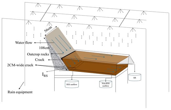
As mentioned above, the simulated rainfall experiments were conducted through the self-initiated steel tank and an automatic slot-type, downward-spraying artificial rainfall equipment (manufactured by Beijing Yike Lide Ecological Environment Technology Co., Ltd. (Beijing, China), Model: EL-RS3). The steel tank simulating the rock–soil structure comprised three parts: the soil tank, flow collection device, and supporting structure (Figure 1). The length, width, and depth of the soil tank were 100, 56, and 33 cm, respectively. The slope gradient could be adjusted between 0 and 50° through adjusting the supporting structure. The exposed bedrock with a catchment surface path of the slope was simulated through a rock slab with a certain roughness similar to rock surfaces in the sampling area, whose IRS value can be adjusted from 30 to 90°. At the bottom of the soil tank, a 2 cm wide crack was strategically opened at the contact zone between the bedrock surface and soil to collect the RSI flow generated along the RSI. Other cracks with a width of 2 cm were opened at the edges away from the RSI to collect the non-RSI flow generated through soil infiltration. The spraying rainfall equipment was positioned at a height of 4.5 m, where the terminal speed of raindrops was similar to that of natural rainfall. The rainfall intensity was automatically adjusted within the range of 10–200 mm/h with an adjustment time of less than 30 s and adjustment accuracy of ±7 mm/h. The effective area of rainfall was 4.5 m × 4.5 m. The raindrop distribution achieved 85% uniformity [15].
Figure 1.
Schematic of the simulated slope with multi-path runoff.
2.2. Experimental Design
Based on field investigations, the slope gradient of the soil tank was set to 15°, representing the average condition in the sampling sites. Considering the influence of RSI-Cracks on rock surface flow [23], the shapes of the bedrock surface were designed to a straight type. This situation is also beneficial for designing the conditions of RSI-Cracks. Two experimental conditions, namely, the presence and absence of RSI-Cracks, were considered, wherein the cracks were 1.0 and 10 cm in width and depth, respectively. Based on our previous results [15,23], R and IRS were used for the experimental conditions. Among them, four levels of R values were established, namely, 10, 25, 50, and 75 mm/h, based on the statistical analysis of multi-year rainfall events in the study area. The IRS was designed to three levels, namely, 45, 60, and 75°. Notably, the IRS values and slope gradient of the soil tank were not the same but both were established angles in the horizontal direction. Considering the changes in the effective catchment area and height of bedrocks caused by IRS, we adopted a fixed bedrock height and varying IRS values. In this case, different IRS values will result in different bedrock surface lengths, which is more consistent with the natural conditions of bedrock surfaces with different IRS values around bedrock outcrops. Hence, the height of bedrock was considered to be 60 cm. The lengths of bedrock for the three levels of IRS values were 184 (45°), 134 (60°), and 108 cm (75°), respectively. This is attributed to the presence of a larger bedrock length when the IRS is smaller around a bedrock outcrop. A total of 72 rainfall events were conducted, wherein each rainfall event was repeated thrice.
2.3. Rainfall Simulation
The rainfall experiments were conducted in the rainfall hall at Guizhou University, China. Based on the above designs, a pre-rainfall event with an intensity of less than 10 mm/h was conducted after filling the soil into the steel tank. Subsequently, a standing time of 24 h was required to ensure the settling of soil and consistent initial soil moisture content before each simulated rainfall experiment. During each rainfall event, the timing started after rainfall. It was recorded as the initial runoff production time when runoff was observed in the runoff collection device. The multi-path runoff samples, including surface runoff (SR), RSI flow, and non-RSI flow, were collected at 5 min intervals. The runoff volume was measured using a graduated cylinder. The sum of RSI and non-RSI flow collected was used as the underground leakage loss of multi-path runoff. Three rain gauges were strategically installed on both sides of the steel tank to determine the actual rainfall intensity during rainfall. Each rainfall event lasted 90 min. At the end of each rainfall event, the soil in the steel tank was replaced.
2.4. Calculation of Parameters
The total effective catchment area of the rock–soil structure slope is the sum of horizontal projection areas of the exposed bedrock surface and soil surface [15]. The total effective catchment area can be calculated by the following equations:
where ATS is the total effective catchment area of the slope (m2); ARS is the effective catchment area of the exposed bedrock surface (m2); ASS is the effective catchment area of the soil surface (m2); WRS is the width of the exposed bedrock surface (m); LRS is the length of the exposed bedrock surface (m); WSS is the width of the soil surface (m); LSS is the length of the soil surface (m); and α is the IRS (°).
ARS = WRS·LRS·cos α
ASS = WSS·LSS·cos 15°
ATS = ARS + ASS
Runoff yield rate (Rr) is the amount of runoff per unit time and area, and is calculated using the following equation:
where Rr1, Rr2, and Rr3 are the runoff yield rates at the surface, RSI, and non-RSI (L/(min·m2)), respectively; Q1, Q2, and Q3 are the volume of runoff yields at the surface, RSI, and non-RSI (L), respectively; T is the sampling interval (min); and ATS is the effective catchment area of the slope (m2).
Rr1 = Q1/(T·ATS)
Rr2 = Q2/(T·ARS)
Rr3 = Q3/(T·ASS)
3. Results
3.1. Production Process of Multi-Path Runoff on Slope
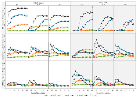
The production processes of multi-path runoff were similar between the conditions with and without RSI-Cracks on the slope (Figure 2). Among them, the surface runoff showed a trend that first increased and subsequently stabilised regardless of the presence or absence of RSI-Cracks. Meanwhile, both the non-RSI and RSI flow showed a trend that first increased and subsequently decreased to stabilisation. The RSI-Cracks do not persist during rainfall, especially when rainfall intensity is higher, the RSI-Cracks will close faster, which is also an important reason for the decrease in RSI and non-RSI flow, and the increase in surface runoff. The multi-path runoff was different in the runoff yield rate influenced by the R and the IRS values but largely unchanged in the trend of runoff production processes. With increasing R, the runoff yield rates of multi-path runoff increased. In contrast to the effect of R, with increasing IRS, both the surface runoff and RSI flow decreased in the runoff yield rate. In particular, the increase in IRS inhibited the production of surface runoff and RSI flow. However, non-RSI flow did not show obvious changes with changing IRS and R. This may be ascribed to the fact that non-RSI flow occurs more through soil infiltration.
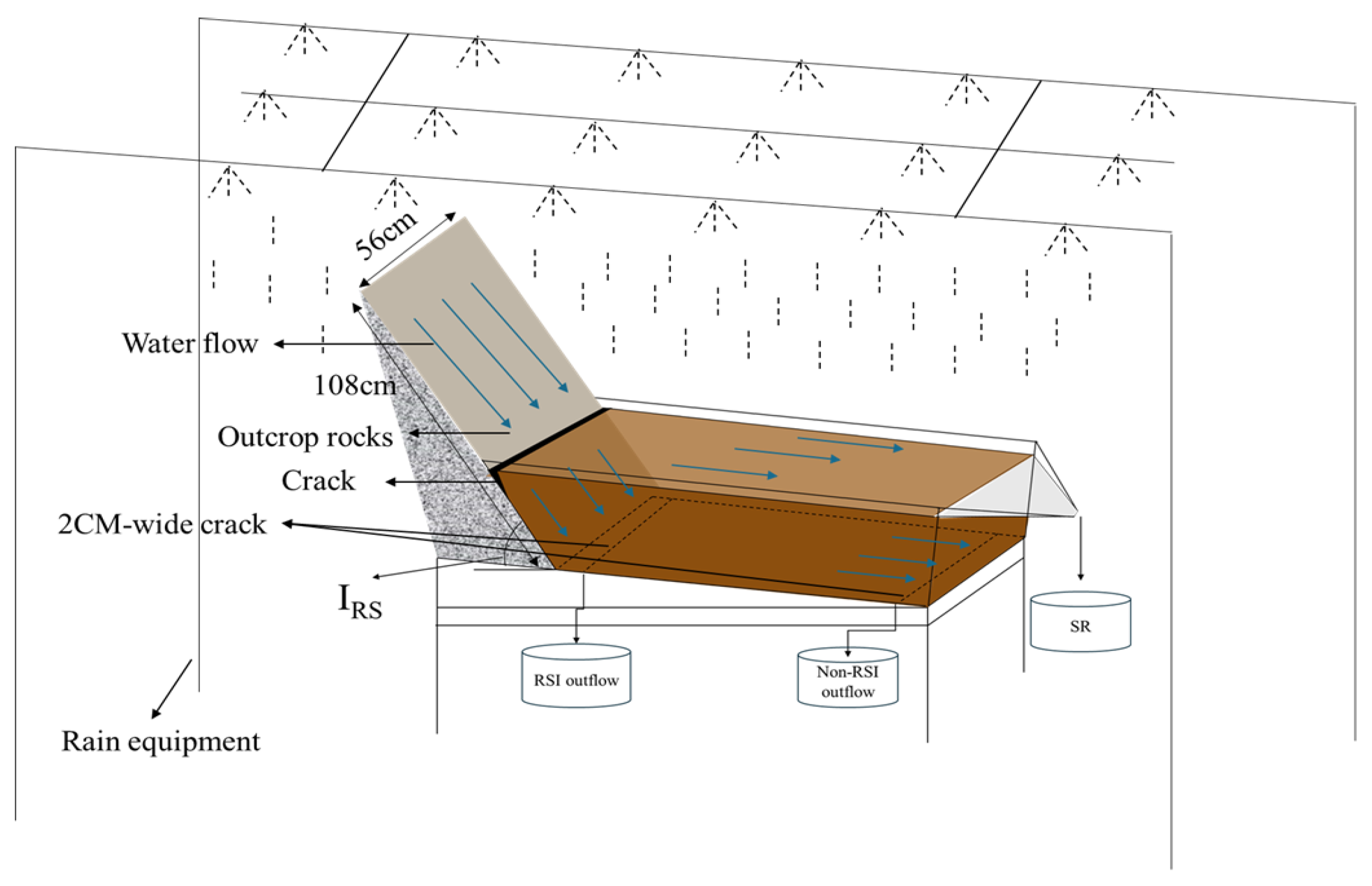
Figure 2.
Yielding process of multi-path runoff on slopes with and without rock–soil interface (RSI)-Cracks. “RSI-Cracks” and “no RSI-Cracks” represent slopes with and without cracks at the RIS, respectively. The shaded area represents the result of the condition with RSI-Cracks.
3.2. Output Characteristics of Multi-Path Runoff on Slope
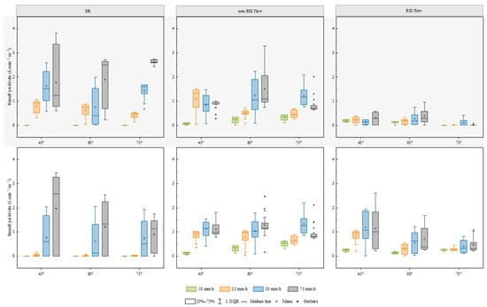
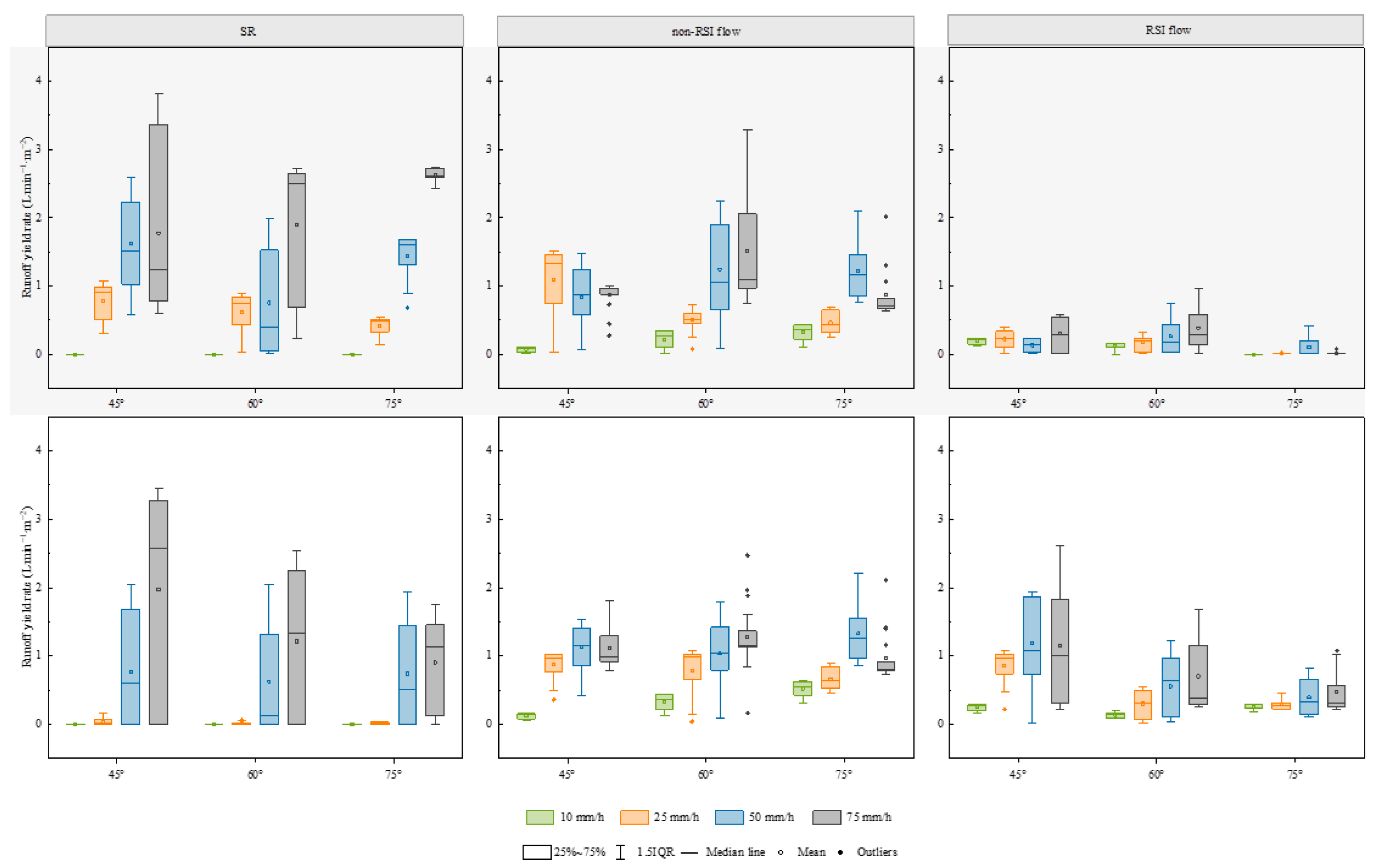
The slopes with and without RSI-Cracks did not indicate SR under lower rainfall intensities (Figure 3). However, SR only occurred when the R value was greater than 25 mm/h. With increasing rainfall intensity, the output proportion of SR was characterised by the advancement of the initial runoff yield time and increase in runoff yield rate (Figure 2). Notably, the runoff yield rates of SR on slopes with RSI-Cracks were consistently lower than those without RSI-Cracks. In contrast, the runoff yield rate of RSI flow in the presence of RSI-Cracks was significantly higher than that in the absence of RSI-Cracks. Although the production process of SR was similar under the two different conditions, namely, a trend that first increases and subsequently stabilises with increasing rainfall duration, the RSI flow on slopes with RSI-Cracks required a longer time to reach stabilisation compared with that without RSI-Cracks. The influence of IRS on flow production on the slope differed from that of R. In particular, an increase in IRS led to a decrease in the mean runoff yield rate for SR and RSI flow, whereas that for non-RSI flow remained relatively stable. Additionally, the runoff yield of SR on slopes with RSI-Cracks was consistently lower than that without RSI-Cracks, whereas RSI flow showed the opposite trend. This change suggested that RSI-Cracks could increase the conversion of water to RSI flow on this slope.
Figure 3.
Statistical characteristics of multi-path runoff on slopes with and without rock–soil interface (RSI)-Cracks. The shaded area represents the result of the condition with RSI-Cracks.
3.3. Contribution Distribution of Multi-Path Runoff on Slope
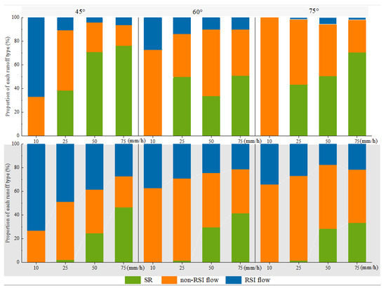
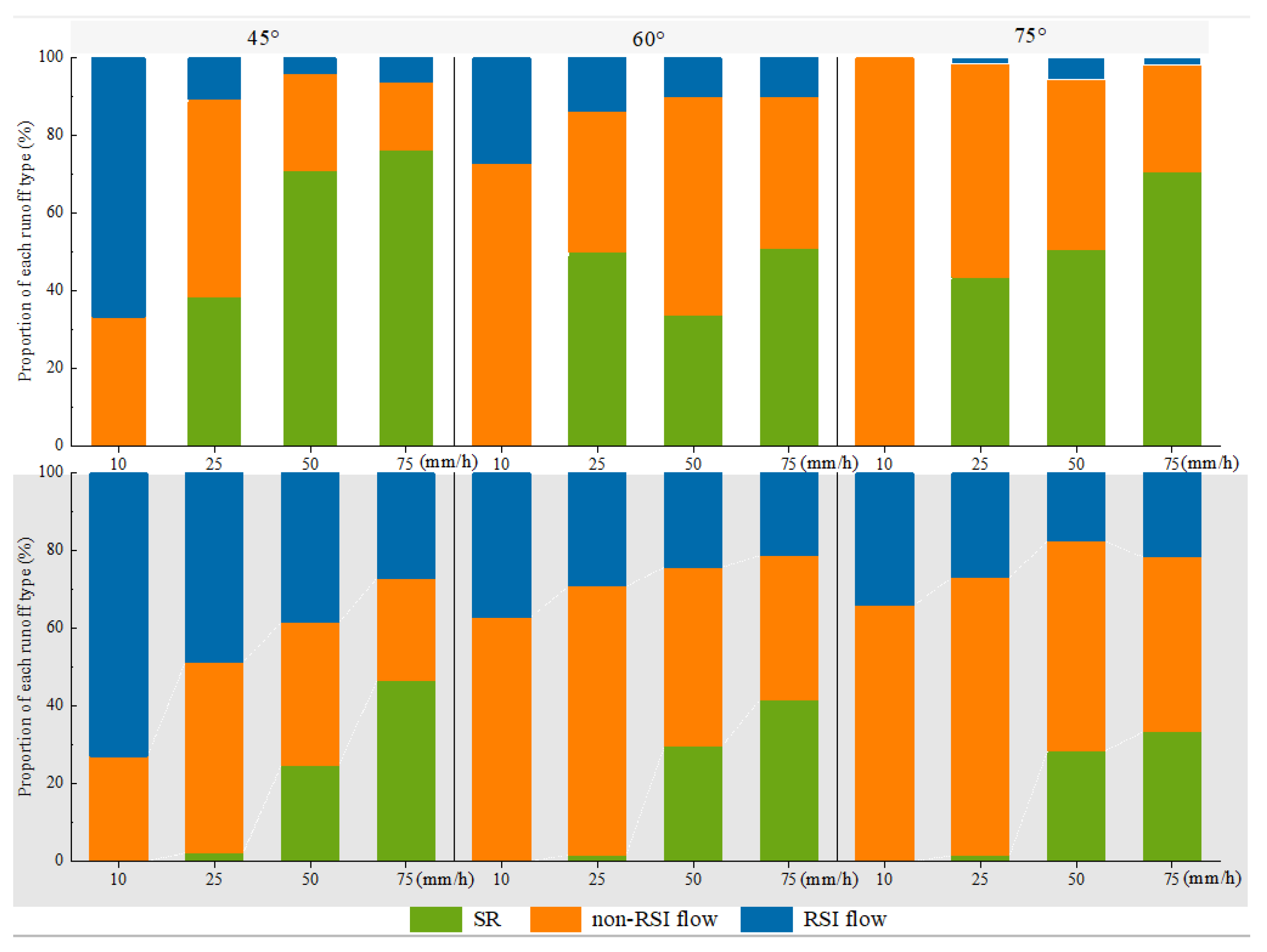
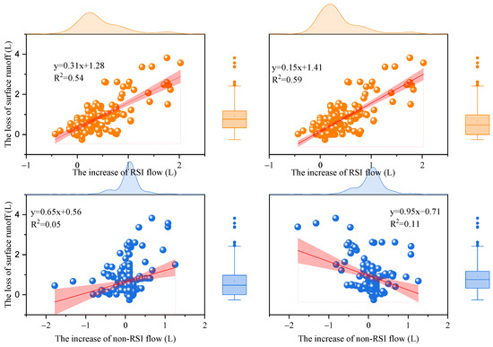
The output proportion of SR obtained from slopes with RSI-Cracks was consistently lower than that without RSI-Cracks under all simulated rainfall events, with a range of decrease of 4–46% (Figure 4). Conversely, the output proportion of RSI flow obtained from slopes with RSI-Cracks increased by 6–38% compared with that without RSI-Cracks. In contrast, the output proportion of non-RSI flow runoff was weakly affected by RSI-Cracks, showing a relatively stable characteristic in the two experimental conditions (Figure 4). It was further compared between the runoff yield without and with RSI-Cracks, subtracting the value of the latter from the former under corresponding conditions (Figure 5). As indicated, the decrease in SR was strongly correlated with the increase in RSI flow under different IRS and R conditions. However, the decrease in SR was not correlated with the increase in non-RSI flow. This suggests that RSI-Cracks affected the multi-path runoff distributions, wherein rainwater was exported more in the form of subsurface runoff, especially for RSI flow.
Figure 4.
Output proportion of multi-path runoff on slopes with and without rock–soil interface (RSI)-Cracks. The shaded area represents the result of the condition with RSI-Cracks.
Figure 5.
Regression relationship between the loss of surface runoff and increase in rock–soil interface (RSI) flow or non-RSI flow caused by RSI-Cracks. The loss of surface runoff is the value obtained by subtracting the surface runoff from the slope without a RSI-Crack from that with a RSI-Crack. The box and whisker plots are the concentration and distribution of the increase of RSI flow or non-RSI flow.
3.4. Influencing Factors of Multi-Path Runoff Leakage Loss
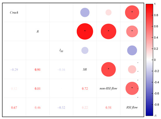
RSI-Cracks, R, and IRS showed a great influence on multi-path runoff production on the slope. As shown in Figure 6, the R value was significantly positively correlated (p < 0.05) with all multi-path runoffs, which acted as the main factor controlling runoff generation from the slope. In contrast, the IRS value was insignificantly negatively correlated with multi-path runoff. In contrast to the influence caused by R and IRS, the influence of RSI-Cracks manifested in two aspects. RSI-Cracks weakly decreased SR and non-RSI flow but strongly increased RSI flow. RSI-Cracks tend to facilitate the conversion of more rainfall into RSI flow, causing the underground leakage of runoff.
Figure 6.
Spearman correlation analysis of multi-path runoff and influencing factors. * indicates p < 0.05.
To further determine the effect of RSI-Cracks on the multi-path runoff loss from the slope, we compared the relationships between R, IRS, and the three paths runoffs at slopes with and without RSI-Cracks. As presented in Table 1, R is still the main factor influencing multi-path runoff loss. In both conditions, R was positively correlated with all three paths of runoffs, particularly showing significant positive correlations with SR (p < 0.01) and non-RSI flow (p < 0.05). Additionally, the difference is that the RSI flow on the slope with RSI-Cracks was significantly correlated with R, but the positive correlation of the RSI flow with R on the slope without RSI-Cracks was insignificant. This suggested that RSI-Cracks significantly altered the fundamental relationship between R and the multi-path runoff loss from the slope. Moreover, RSI-Cracks also dramatically altered the influence of IRS on multi-path runoff loss from the slope. In the absence of RSI-Cracks, the RSI flow was significantly negatively correlated with IRS, whereas this relationship did not exist in the presence of RSI-Cracks. These findings suggest that RSI-Cracks fundamentally alter the multi-path runoff loss from the slope by changing the influence of R and IRS on the output of multi-path runoff.
Table 1.
Spearman correlation analysis of conditions with and without RSI-Cracks. * indicates p < 0.05, ** indicates p < 0.01.
4. Discussion
4.1. Formation Process of Flows at the Rock–Soil Interface
Both the surface and substance runoff processes were greatly influenced by outcrops on rocky desertification slopes [15,23,24,25]. These outcrops played an important role in the infiltration of precipitation into the underground through karst cracks [21,26]. The process of the movement and underground transformation of surface rainwater on karst slopes mainly occurs at the RSI [10,27]. However, most RSIs were not present as a tightly integrated hole in karst areas, and a certain number of cracks still existed between the bedrock surface and soil under the alternation of dry and wet conditions, which, to some extent, altered the runoff generation from the slope. Thus, the formation of RSI flow was mainly influenced by the complex rock–soil structure. Therefore, the production of RSI flow was mainly ascribed to rainfall accumulating on the bedrock-surface-produced rock surface flow [14,15], of which a large portion infiltrated downward through RSI-Cracks, and the shallow soil and well-developed soil macropores [28,29], which caused rainwater to infiltrate into the soil during precipitation. The infiltrated water percolated vertically through these soil macropores and was transported along the RSI [26,30]. Moreover, owing to the interaction between soil matrix properties and bedrock morphology, the infiltrating water tended to flow into deeper soil through the RSI [5,31]. This greatly increased the conversion efficiency of infiltration water to RSI flow, affecting the latter’s formation. However, based on our experiment, it can be found that the RSI-Cracks undergo cracking and closure during rainfall, and whether the closure of the cracks can provide a channel for the formation of RSI flow still needs further observation.
4.2. Effect of Cracks on the Transformation of Rainwater
We found significant differences in the distributions of multi-path runoff between the conditions with and without RSI-Cracks (Figure 4). In particular, RSI-Cracks dramatically changed the contribution ratio of SR, non-RSI flow, and RSI flow, suggesting that RSI-Cracks played a crucial role in the formation and output of multi-path runoff on the slope (Figure 6; Table 1). These findings confirmed the unique hydrological characteristics of karst slopes, where irregular bedrock covers shallow highly weathered soil and where a widespread network of fissures promotes deep seepage [32]. This also explained the paradoxical phenomenon of high precipitation but limited SR, with subsurface flow being the dominant hydrologic process in the region [33,34]. In particular, RSI-Cracks acted as a preferential flow pathway to divert water from the bedrock surface downward to the deeper soil layers, which effectively enhances deep seepage and reduces SR production [35]. In this study, a significant correlation was observed between the decrease in SR and increase in RSI flow (Figure 5), which suggested that RSI-Cracks were conducive to the distribution of subsurface runoff, especially to RSI flow. Subsurface runoff dominated the runoff process under low-intensity rainfall conditions [15,20], which was consistent with the observations from slopes without RSI-Cracks. However, slopes with RSI-Cracks showed that the proportion of RSI flow is similar to that of non-RSI flow (Figure 4). This further indicates that the production of RSI flow is more prominent on slopes with RSI-Cracks. In slopes without RSI-Cracks, high-intensity rainfall events (75 mm/h) could fundamentally alter this phenomenon, triggering a shift in multi-path runoff output from the slope, which is characterised by a significant decrease in the proportions of RSI and non-RSI flow (Figure 4), with SR becoming the dominant pathway on the slope [36,37]. However, the runoff output from slopes with RSI-Cracks is still dominated by subsurface runoff (Figure 4). These results highlight the influence of RSI-Cracks on the runoff output and deepen the understanding of the formation and output of multi-path runoff on the slope.
4.3. Effect of RSI-Crack Flow on Soil Erosion
In this experiment, the soil closely adhering to the rock surface gradually collapsed towards RSI-Cracks, leading to the gradual closure of RSI-Cracks during rainfall. This phenomenon strongly indicated that RSI-Cracks became a channel for the leakage of soil particles on the slope. Li et al. [38] also highlighted that soil particles migrate downward along subsurface cracks after multiple rainfall events. However, the complex geomorphology of rocky desertification landforms has resulted in great complexity in the study of soil erosion. Although soil underground leakage loss was considered an important erosion mechanism in karst areas, direct quantitative indicators were lacking [33]. The underground porosity and connectivity, as well as the size of the sinkhole, provided an important basis for inferring the underground leakage process of soils on micro-slopes [39,40]. We believe that RSI-Cracks were also an important characteristic parameter affecting the occurrence of soil underground leakage. During rainfall, RSI-Cracks can convert more rock surface flow into RSI flow (Figure 5), thereby greatly increasing the erosive capacity of RSI flow. Notably, slopes with RSI-Cracks could reduce SR compared with those without any, reducing the surface erosive capacity [3]. Under the condition of higher R and long-duration rainfall (Figure 2), RSI-Cracks will be closed, which promoted the formation of SR on the slope, ultimately shifting the dominant erosion pathway from the subsurface to the surface. However, the migration rate of soil particles to underground areas was generally slow [41,42], which highlighted the limitations of extrapolating long-term erosion patterns from a single observation. Thus, a comprehensive understanding of the impact of RSI-Cracks on the multi-path runoff leakage mechanisms may require long-term monitoring to capture temporal variations in soil migration.
5. Conclusions
RSI-Cracks developed following wet–dry alternation between the bedrock and soil had a significant effect on the generation process of multi-path runoff from the slope, which significantly altered the runoff distribution pattern (p < 0.05) and exacerbated subsurface runoff seepage. In this study, the effects of R and IRS on the generation process of multi-path runoff from slope with and without RSI-Cracks were systematically investigated. Our results showed that R dominated the generation and output of multi-path runoff, whereas the effect of IRS was negligible. Compared with that on slopes without RSI-Cracks, the proportion of surface runoff on those with RSI-Cracks is reduced, with a reduction range of 4–46%. Conversely, RSI-Cracks promoted an increase in the proportion of outflow at the RSI (RSI flow), with a range of increase of 7–38%. This is an important reason for the aggravation of subsurface water leakage through RSI-Cracks. However, no significant change was observed in the water loss caused by internal soil seepage on slopes with or without RSI-Cracks. These findings provide novel insights into underground water loss, offering valuable implications for the construction and improvement of hydrological models in karst areas.
Author Contributions
Conceptualization, X.P.; methodology, X.P.; software, X.C. and W.M.; validation, X.C.; formal analysis, X.C.; investigation, X.C., Q.D. and L.C.; resources, X.P. and Q.D.; data curation, X.C., Y.H. and L.C.; writing—original draft preparation, X.C.; writing—review and editing, X.P.; visualisation, L.C. and W.M.; supervision, X.P.; project administration, X.P.; funding acquisition, X.P. All authors have read and agreed to the published version of the manuscript.
Funding
This research was funded by the Guizhou Provincial Key Technology R&D Program (QKHZC [2023]YB104), National Natural Science Foundation of China (42267054 and 42007067), Science and Technology Fund of Guizhou (ZK[2023]-236), and National Natural Science Foundation of China (32460429).
Data Availability Statement
The data presented in this study are available upon request from the corresponding author.
Conflicts of Interest
The authors declare no conflicts of interest.
References
- Yuan, D.X. Rock desertification in the subtropical karst of south China. Z. Geomorphol. 1997, 108, 81–90. [Google Scholar]
- Jiang, Z.C.; Lian, Y.Q.; Qin, X.Q. Rocky desertification in Southwest China: Impacts, causes, and restoration. Earth-Sci. Rev. 2014, 132, 1–12. [Google Scholar] [CrossRef] [Scilit]
- Li, R.; Jing, J.; Tang, Z.; Xiong, L. Effects of Karst Vegetation-Soil-Rock Composite Structure on Soil and Water Flow/Leakage Processes and Driving Factors at the Micro-Plot Scale. Soil Tillage Res. 2025, 247, 106370. [Google Scholar] [CrossRef] [Scilit]
- Zhao, Z.; Shen, Y.; Jiang, R.; Wang, Q. Rock Outcrops Change Infiltrability and Water Flow Behavior in a Karst Soil. Vadose Zone J. 2020, 19, e20002. [Google Scholar] [CrossRef] [Scilit]
- Liu, Y.; Chen, J.; Zhang, X.; Li, Q.; Du, Y.; Liu, J.; Tao, J. Herbaceous Community Species Composition and Productivity Are Affected by Soil Depth and Funnel Effect in a Simulated Karst Experiment. Glob. Ecol. Conserv. 2020, 22, e01033. [Google Scholar] [CrossRef] [Scilit]
- Liu, D.; She, D. The Effect of Fracture Properties on Preferential Flow in Carbonate-Derived Laterite from Karst Mountainous Agroforestry Lands. Soil Tillage Res. 2020, 203, 104670. [Google Scholar] [CrossRef] [Scilit]
- Ao, L.; Wu, Y.; Xu, Q.; Zhou, Y.; Chen, X.; Liang, P.; Fu, Z.; Chen, H. The Role of Bedrock Topography in the Runoff Process and Soil Erosion on Karst Steep Slopes. Land Degrad. Dev. 2025, 36, 533–544. [Google Scholar] [CrossRef] [Scilit]
- D’Ettorre, U.S.; Liso, I.S.; Parise, M. Desertification in Karst Areas: A Review. Earth Sci. Rev. 2024, 253, 104786. [Google Scholar] [CrossRef] [Scilit]
- Liu, T.; Peng, X.; Dai, Q.; Xu, S. Role of the Preferential Flow at Rock–Soil Interface in the Water Leaking Process in near-Surface Fissures Filled with Soils in the Karst Rock Desertification Area. Appl. Water Sci. 2022, 12, 208. [Google Scholar] [CrossRef] [Scilit]
- Fu, Z.Y.; Chen, H.S.; Zhang, W.; Xu, Q.X.; Wang, S.; Wang, K.L. Subsurface Flow in a Soil-Mantled Subtropical Dolomite Karst Slope: A Field Rainfall Simulation Study. Geomorphology 2015, 250, 1–14. [Google Scholar] [CrossRef] [Scilit]
- Zhang, S.; Ma, Q.; Qihua, K.; Zhang, K.; Zhu, T. Effects of Rock Outcrops on Runoff and Erosion from Karst Slopes under Simulated Rainfall. Land Degrad. Dev. 2024, 35, 949–967. [Google Scholar] [CrossRef] [Scilit]
- Cerdà, A. The Influence of Geomorphological Position and Vegetation Cover on the Erosional and Hydrological Processes on a Mediterranean Hillslope. Hydrol. Process. 1998, 12, 661–671. [Google Scholar] [CrossRef] [Scilit]
- Calvo-Cases, A.; Boix-Fayos, C.; Imeson, A.C. Runoff Generation, Sediment Movement and Soil Water Behaviour on Calcareous (Limestone) Slopes of Some Mediterranean Environments in Southeast Spain. Geomorphology 2003, 50, 269–291. [Google Scholar] [CrossRef] [Scilit]
- Sohrt, J.; Ries, F.; Sauter, M.; Lange, J. Significance of Preferential Flow at the Rock Soil Interface in a Semi-Arid Karst Environment. CATENA 2014, 123, 1–10. [Google Scholar] [CrossRef] [Scilit]
- Zeng, X.; Peng, X.; Liu, T.; Dai, Q.; Chen, X. Runoff Generation and Erosion Processes at the Rock–Soil Interface of Outcrops with a Concave Surface in a Rocky Desertification Area. Catena 2024, 239, 107920. [Google Scholar] [CrossRef] [Scilit]
- Lange, J.; Greenbaum, N.; Husary, S.; Ghanem, M.; Leibundgut, C.; Schick, A.P. Runoff Generation from Successive Simulated Rainfalls on a Rocky, Semi-Arid, Mediterranean Hillslope. Hydrol. Process. 2003, 17, 279–296. [Google Scholar] [CrossRef] [Scilit]
- Ries, F.; Lange, J.; Schmidt, S.; Puhlmann, H.; Sauter, M. Recharge Estimation and Soil Moisture Dynamics in a Mediterranean, Semi-Arid Karst Region. Hydrol. Earth Syst. Sci. 2015, 19, 1439–1456. [Google Scholar] [CrossRef] [Scilit]
- Tang, C.-S.; Zhu, C.; Cheng, Q.; Zeng, H.; Xu, J.-J.; Tian, B.-G.; Shi, B. Desiccation Cracking of Soils: A Review of Investigation Approaches, Underlying Mechanisms, and Influencing Factors. Earth Sci. Rev. 2021, 216, 103586. [Google Scholar] [CrossRef] [Scilit]
- Xu, J.; Ding, T.; Wu, D.; Zhang, J.; Wen, N.; Biswas, A.; Liu, G. Extracting the 3D Spatial Structure of Soil Cracks in the North China Plain from Paraffin Casting and Exploring the Developmental Patterns of Vertical Cross-Sectional Morphology of the Cracks. Geoderma 2023, 436, 116554. [Google Scholar] [CrossRef] [Scilit]
- Peng, X.; Li, C.; Dai, Q.; Xu, S.; Zang, J. Morphological Development of Drying Shrinkage Cracks at the Rocksoil Interface in a Karst Rocky Desertification Area. J. Hydrol. Reg. Stud. 2024, 54, 101894. [Google Scholar] [CrossRef] [Scilit]
- Hou, F.; Cheng, J.; Guan, N. Investigating the Effect of Soil Cracks on Preferential Flow Using a Dye Tracing Infiltration Experiment in Karst in Southwest China. Land Degrad. Dev. 2023, 34, 1612–1628. [Google Scholar] [CrossRef] [Scilit]
- Wilcox, B.P.; Taucer, P.I.; Munster, C.L.; Owens, M.K.; Mohanty, B.P.; Sorenson, J.R.; Bazan, R. Subsurface Stormflow Is Important in Semiarid Karst Shrublands. Geophys. Res. Lett. 2008, 35, L10403. [Google Scholar] [CrossRef] [Scilit]
- Cen, L.; Peng, X.; Dai, Q.; Li, C.; Yi, X. Creep Leakage Process of Remaining Soils in Near-Surface Fissures in a Karst Area with Bedrock Outcrops. Catena 2023, 221, 106802. [Google Scholar] [CrossRef] [Scilit]
- Zhao, Z.; Shen, Y.; Shan, Z.; Yu, Y.; Zhao, G. Infiltration Patterns and Ecological Function of Outcrop Runoff in Epikarst Areas of Southern China. Vadose Zone J. 2018, 17, 170197. [Google Scholar] [CrossRef] [Scilit]
- Zhang, Y.; Song, L.; Bi, Y.; He, B.; Zeng, R.; Li, T. Effects of the Angle between the Rock Strata and Slope on Flow Hydraulics and Sediment Yield in Karst Trough Valley: Laboratory Scour Experiment. Int. J. Sediment Res. 2024, 39, 100–109. [Google Scholar] [CrossRef] [Scilit]
- Smets, T.; López-Vicente, M.; Poesen, J. Impact of Subsurface Rock Fragments on Runoff and Interrill Soil Loss from Cultivated Soils. Earth Surf. Process. Landf. 2011, 36, 1929–1937. [Google Scholar] [CrossRef] [Scilit]
- Bou Kheir, R.; Abdallah, C.; Khawlie, M. Assessing Soil Erosion in Mediterranean Karst Landscapes of Lebanon Using Remote Sensing and GIS. Eng. Geol. 2008, 99, 239–254. [Google Scholar] [CrossRef] [Scilit]
- Bodner, G.; Leitner, D.; Kaul, H.-P. Coarse and Fine Root Plants Affect Pore Size Distributions Differently. Plant Soil 2014, 380, 133–151. [Google Scholar] [CrossRef] [Scilit]
- Chen, C.; Zou, X.; Singh, A.K.; Zhu, X.; Zhang, W.; Yang, B.; Jiang, X.; Liu, W. Effects of Hillslope Position on Soil Water Infiltration and Preferential Flow in Tropical Forest in Southwest China. J. Environ. Manag. 2021, 299, 113672. [Google Scholar] [CrossRef] [Scilit] [PubMed]
- Fu, Z.; Chen, H.; Xu, Q.; Jia, J.; Wang, S.; Wang, K. Role of Epikarst in Near-Surface Hydrological Processes in a Soil Mantled Subtropical Dolomite Karst Slope: Implications of Field Rainfall Simulation Experiments. Hydrol. Process. 2016, 30, 795–811. [Google Scholar] [CrossRef] [Scilit]
- Cai, L.; Xiong, K.; Liu, Z.; Li, Y.; Zhu, D.; Mu, Y.; Chen, Y.; Zhou, R.; Yan, X. Water Competition among Coexisting Plants in Rock-Dominated Habitats of Subtropical Karst Desertification. Agric. Ecosyst. Environ. 2025, 381, 109419. [Google Scholar] [CrossRef] [Scilit]
- Wang, S.; Yan, Y.; Fu, Z.; Chen, H. Rainfall-Runoff Characteristics and Their Threshold Behaviors on a Karst Hillslope in a Peak-Cluster Depression Region. J. Hydrol. 2022, 605, 127370. [Google Scholar] [CrossRef] [Scilit]
- Peng, X.; Dai, Q. Drivers of Soil Erosion and Subsurface Loss by Soil Leakage during Karst Rocky Desertification in SW China. Int. Soil Water Conserv. Res. 2022, 10, 217–227. [Google Scholar] [CrossRef] [Scilit]
- Lu, S.; Liu, M.; Yi, J.; Zhang, H.; Wan, J. Responses of Soil Moisture at Different Topographic Positions to Rainfall Events along a Steep Subtropical Forested Hillslope. Hydrol. Process. 2024, 38, e15164. [Google Scholar] [CrossRef] [Scilit]
- Zhou, B.; Yang, S.; Lou, H.; Gong, J.; Pan, Z.; Wang, H.; Yi, Y.; Gao, C.; Huang, X.; Wu, W. Rainfall Water Collection and Irrigation via Stone Bud and Karren on Karst Rocky Desertification Slopes: Application and Benefit Analysis. Agric. Water Manag. 2024, 304, 109087. [Google Scholar] [CrossRef] [Scilit]
- Li, T.; Bi, Y.; Song, L.; He, B. Soil Loss and Runoff Characteristics in Response to Varying Underground Fissure Ratios on Karst Slopes with Thin Soil Layers in Southwest China. J. Hydrol. Reg. Stud. 2025, 58, 102225. [Google Scholar] [CrossRef] [Scilit]
- He, Z.; Gu, X.; Wang, M.; Xu, M. Study on the Response Mechanism of Extreme Rainfall-Runoff in the Coupled Structure of the Karst Basin in Central Guizhou. J. Water Process Eng. 2025, 71, 107158. [Google Scholar] [CrossRef] [Scilit]
- Li, J.; Chen, S.; Long, X.; Hu, P.; Xiao, D.; Zhang, W.; Moldovan, O.T.; Zhao, J.; Wang, K. Linking Rock Outcrop Size and Distance to Soil Multifunctionality in Mountain Ecosystems. Funct. Ecol. 2025, 39, 1288–1301. [Google Scholar] [CrossRef] [Scilit]
- Hu, J.; Motagh, M.; Guo, J.; Haghighi, M.H.; Li, T.; Qin, F.; Wu, W. Inferring Subsidence Characteristics in Wuhan (China) through Multitemporal InSAR and Hydrogeological Analysis. Eng. Geol. 2022, 297, 106530. [Google Scholar] [CrossRef] [Scilit]
- Dall’Alba, V.; Neven, A.; de Rooij, R.; Filipponi, M.; Renard, P. Probabilistic Estimation of Tunnel Inflow from a Karstic Conduit Network. Eng. Geol. 2023, 312, 106950. [Google Scholar] [CrossRef] [Scilit]
- Zhang, X.; Bai, X.; He, X. Soil Creeping in the Weathering Crust of Carbonate Rocks and Underground Soil Losses in the Karst Mountain Areas of Southwest China. Carbonates Evaporites 2011, 26, 149–153. [Google Scholar] [CrossRef] [Scilit]
- Feng, T.; Chen, H.; Wang, K.; Nie, Y.; Zhang, X.; Mo, H. Assessment of Underground Soil Loss via the Tapering Grikes on Limestone Hillslopes. Agric. Ecosyst. Environ. 2020, 297, 106935. [Google Scholar] [CrossRef] [Scilit]

Disclaimer/Publisher’s Note: The statements, opinions and data contained in all publications are solely those of the individual author(s) and contributor(s) and not of MDPI and/or the editor(s). MDPI and/or the editor(s) disclaim responsibility for any injury to people or property resulting from any ideas, methods, instructions or products referred to in the content. |
© 2026 by the authors. Licensee MDPI, Basel, Switzerland. This article is an open access article distributed under the terms and conditions of the Creative Commons Attribution (CC BY) license.