Next Issue
Volume 15, May
Previous Issue
Volume 15, March


ISPRS Int. J. Geo-Inf., Volume 15, Issue 4 (April 2026) – 41 articles

Cover Story (view full-size image): 
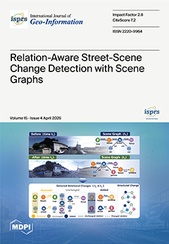
Street-view imagery provides rich and human-centered information for fine-grained urban monitoring, but most existing change detection methods focus mainly on pixel differences or isolated object changes. This paper presents SSPRCD, a scene graph-based framework that models street-scenes as spatial knowledge graphs and analyzes change through cross-temporal alignment, graph differencing, and structural quantification. This method identifies added, removed, and unchanged entities and relations, while normalized graph edit distance and graph embedding similarity measure scene-level structural discrepancies. Experiments on the TSUNAMI benchmark show that SSPRCD delivers interpretable, relation-aware change evidence for urban information updating, compliance inspection, and post-disaster assessment. View this paper
  • Issues are regarded as officially published after their release is announced to the table of contents alert mailing list.
  • You may sign up for e-mail alerts to receive table of contents of newly released issues.
  • PDF is the official format for papers published in both, html and pdf forms. To view the papers in pdf format, click on the "PDF Full-text" link, and use the free Adobe Reader to open them.
Order results
Result details
Select all
Export citation of selected articles as:
32 pages, 12029 KB  
Article
Designing Effective Multi-Window Map Interfaces: The Role of Highlighting and Luminance Contrast in Visual Search
by Jing Zhang, Liyu Hu, Yunqi Zhu, Yu Zhang, Xuanyi Kuang, Jingjing Li and Wa Gao
ISPRS Int. J. Geo-Inf. 2026, 15(4), 180; https://doi.org/10.3390/ijgi15040180 - 21 Apr 2026
Viewed by 317
Abstract
Multi-window map interfaces are widely used in geospatial monitoring systems and map-based analytical environments, where users must rapidly locate task-relevant information across multiple spatial displays. Designing visual cues and display conditions that effectively support visual search in such environments remains an important challenge [...] Read more.
Multi-window map interfaces are widely used in geospatial monitoring systems and map-based analytical environments, where users must rapidly locate task-relevant information across multiple spatial displays. Designing visual cues and display conditions that effectively support visual search in such environments remains an important challenge for map interface design. This study examines how luminance contrast and highlighting influence visual search performance in multi-window map interfaces. A within-subject eye-tracking experiment was conducted using five highlighting conditions (No Highlighting as the control condition, Outer Border Highlighting, Text Highlighting, Title-Bar Highlighting, and Background Highlighting) and three luminance-contrast levels (low, medium, and high). Behavioral performance (accuracy and reaction time) and eye-movement measures (total viewing duration, fixation count, saccade count, and time to first fixation) were analyzed to evaluate how perceptual visibility and visual cue structures affect spatial information search. Results show that higher luminance contrast improved accuracy and reduced reaction time, although differences between medium and high contrast were small, suggesting that performance stabilized once a sufficient visibility threshold was reached. All highlighting conditions facilitated search relative to the control condition, with background and title-bar highlighting producing the most efficient gaze behavior and earlier target acquisition. A significant interaction between luminance contrast and highlighting was also observed, indicating that structured highlighting mitigates the performance costs associated with low contrast. Eye-movement evidence further indicates that region-based cues guide attention at the level of spatial interface regions rather than simply increasing local salience. These findings provide empirical guidance for improving spatial information retrieval efficiency in multi-window geospatial interfaces. Full article
Show Figures

Figure 1

28 pages, 6613 KB  
Article
Same Streets, Different Contexts: Personality-Based Differences in Cycling Willingness Revealed from Objective and Subjective Perspectives
by Chenfeng Xu, Yihan Li, Zibo Zhu, Zhengyang Zou, Xing Geng and Yike Hu
ISPRS Int. J. Geo-Inf. 2026, 15(4), 179; https://doi.org/10.3390/ijgi15040179 - 16 Apr 2026
Viewed by 635
Abstract
Against the backdrop of rising psychological stress and declining physical fitness in cities, how streetscape characteristics and Myers–Briggs Type Indicator (MBTI) personality traits jointly influence cycling willingness across different contexts remains underexplored. Using Shenzhen, China, as a case study, we integrated objective bicycle-sharing [...] Read more.
Against the backdrop of rising psychological stress and declining physical fitness in cities, how streetscape characteristics and Myers–Briggs Type Indicator (MBTI) personality traits jointly influence cycling willingness across different contexts remains underexplored. Using Shenzhen, China, as a case study, we integrated objective bicycle-sharing travel records from 2021 and subjective pairwise ratings of 1000 street-view images from 960 participants. Cycling willingness was extrapolated through the TrueSkill algorithm and a ResNet50-based model, while street view elements were extracted via DeepLabV3+ and summarized into five indicators. Multivariate regression and multifactor ANOVA were used to test main and moderating effects across six cycling contexts. Results show that (1) Objective cycling indicators and subjective willingness exhibit a pattern of lower values in the center and higher values in the periphery. (2) The Spatial Green Index, Sky Openness Index, Path Freedom Index, and Facility Accessibility Index are the main influencing factors, while the Interface Enclosure Index has the weakest and most context-dependent effect. (3) Intuition/Feeling traits are more salient in leisure and exploration, Judging/Thinking in fitness and transport, and Extraversion/Feeling in social and companion contexts. These findings provide evidence for optimizing urban street cycling spaces in a multi-context and personality-informed manner. Full article
(This article belongs to the Special Issue Innovative Mobility Services for Smart Cities)
Show Figures

Figure 1

25 pages, 3532 KB  
Article
A Scalable Geodemographic Baseline for Traffic Safety Monitoring in a Middle-Income Country
by Ekinhan Eriskin
ISPRS Int. J. Geo-Inf. 2026, 15(4), 178; https://doi.org/10.3390/ijgi15040178 - 16 Apr 2026
Viewed by 394
Abstract
Road traffic safety is central to socially resilient and sustainable cities, yet many middle-income countries lack harmonized subnational data on exposure, infrastructure, and enforcement. This study examines whether routinely available demographic composition can serve as a practical structural baseline for provincial traffic accident [...] Read more.
Road traffic safety is central to socially resilient and sustainable cities, yet many middle-income countries lack harmonized subnational data on exposure, infrastructure, and enforcement. This study examines whether routinely available demographic composition can serve as a practical structural baseline for provincial traffic accident rates and as a diagnostic layer for richer safety models. Using official province–year data from Türkiye (2008–2019 and 2022–2024; n = 1215), demographic shares by sex, education, and age were treated as compositional inputs and transformed using isometric log-ratio (ILR) methods, with GDP per person included as a scalar covariate. A Tabular Residual Network (ResNet) was trained on the historical panel and evaluated on a post-period calibration/evaluation window (2022–2024), which was used for checkpoint selection and seed screening rather than as an independent held-out test set. Among the evaluated specifications, the ResNet seed-ensemble achieved the strongest performance on the 2022–2024 calibration/evaluation period (R2 = 0.5717), outperforming the best single-seed model (R2 = 0.5539), a province-specific last-value-carried-forward temporal heuristic based on 2019 values (R2 = 0.4779), tree-based tabular benchmarks (Random Forest: R2 = 0.1328; XGBoost: R2 = 0.0706), and pooled statistical reference models (linear: R2 = 0.1375; negative binomial: R2 = 0.0686; Poisson: R2 = −0.0634). Year-wise diagnostics indicated gradual temporal drift, suggesting that periodic recalibration or the inclusion of additional policy-relevant covariates is needed to preserve calibration. Overall, ILR-based compositional geodemography provides a scalable and interpretable baseline for traffic safety monitoring and prioritization in data-constrained settings. Full article
Show Figures

Figure 1

1 pages, 149 KB  
Retraction
RETRACTED: Yang et al. Unraveling Spatial Nonstationary and Nonlinear Dynamics in Life Satisfaction: Integrating Geospatial Analysis of Community Built Environment and Resident Perception via MGWR, GBDT, and XGBoost. ISPRS Int. J. Geo-Inf. 2025, 14, 131
by Di Yang, Qiujie Lin, Haoran Li, Jinliu Chen, Hong Ni, Pengcheng Li, Ying Hu and Haoqi Wang
ISPRS Int. J. Geo-Inf. 2026, 15(4), 177; https://doi.org/10.3390/ijgi15040177 - 16 Apr 2026
Viewed by 368
Abstract
The journal retracts the article titled “Unraveling Spatial Nonstationary and Nonlinear Dynamics in Life Satisfaction: Integrating Geospatial Analysis of Community Built Environment and Resident Perception via MGWR, GBDT, and XGBoost” [...] Full article
19 pages, 3886 KB  
Article
Optimization of the Job–Housing Balance in Megacities by Integrating Commuting Behavior Patterns: A Case Study of Shenzhen
by Yuhong Bai, Shuyan Yang, Changfeng Li and Wangshu Mu
ISPRS Int. J. Geo-Inf. 2026, 15(4), 176; https://doi.org/10.3390/ijgi15040176 - 16 Apr 2026
Viewed by 508
Abstract
Rapid urbanization in megacities has exacerbated the spatial mismatch between employment and housing, necessitating effective spatial optimization strategies. However, classical optimization models often rely on the idealized assumption of “proximity maximization,” failing to account for the complex, nonlinear regularities of actual human mobility. [...] Read more.
Rapid urbanization in megacities has exacerbated the spatial mismatch between employment and housing, necessitating effective spatial optimization strategies. However, classical optimization models often rely on the idealized assumption of “proximity maximization,” failing to account for the complex, nonlinear regularities of actual human mobility. To address this disconnect between theoretical modeling and real-world behavior, this study establishes a job–housing balance optimization framework integrated with empirical commuting patterns. Using Shenzhen as a case study, we analyze citywide commuting big data since 2024 to characterize the power law relationship between commuting population size and distance. We propose a novel optimization model that partitions residential areas into “commuting rings” on the basis of observed distance-decay functions rather than simple Euclidean proximity. We applied the proposed method to current and future planning scenarios and successfully generated spatial regulation schemes that decentralize employment functions to peripheral areas while strategically densifying residential zones. By respecting the “heavy-tailed” nature of commuting distributions, this approach offers urban planners a more robust tool for reducing aggregate commuting burdens without violating the behavioral realities of the workforce. Full article
Show Figures

Figure 1

25 pages, 41819 KB  
Article
Comparative Analysis of Machine Learning–Kriging Integrative Approaches for Enhanced Spatial Prediction of Mineral Exploration Data
by Hosang Han and Jangwon Suh
ISPRS Int. J. Geo-Inf. 2026, 15(4), 175; https://doi.org/10.3390/ijgi15040175 - 15 Apr 2026
Viewed by 470
Abstract
Accurate prediction of mineral concentrations from sparse exploration data is important for resource estimation. This study evaluates hybrid prediction models combining machine learning (ML) and geostatistics to predict aluminum (Al) concentrations. Twelve hybrid configurations were generated by combining six ML backbones—Random Forest, XGBoost, [...] Read more.
Accurate prediction of mineral concentrations from sparse exploration data is important for resource estimation. This study evaluates hybrid prediction models combining machine learning (ML) and geostatistics to predict aluminum (Al) concentrations. Twelve hybrid configurations were generated by combining six ML backbones—Random Forest, XGBoost, AdaBoost, ResNet, U-Net, and Spatial Transformer Network—with Ordinary Kriging (OK) and Universal Kriging (UK). Model performance was evaluated using 10-fold spatial cross-validation (CV) to reduce spatial leakage, and hyperparameters were tuned by grid-search CV within the training folds. For the hybrid models, residual kriging was fitted using cross-fitted out-of-fold residuals to reduce optimistic bias and prevent information leakage. The results showed no consistent performance separation between OK and UK variants. More importantly, the effect of integration was backbone dependent rather than uniformly beneficial. RF-based predictions showed the strongest overall out-of-sample performance, whereas hybrid gains for other backbones were generally modest. After multiple-comparison correction, most differences between standalone and hybrid models were not statistically significant. These findings indicate that increasing model complexity through hybridization does not guarantee improved accuracy and highlight the importance of spatially explicit, bias-aware evaluation when selecting prediction strategies for mineral resource exploration. Full article
(This article belongs to the Topic Geospatial AI: Systems, Model, Methods, and Applications)
Show Figures

Graphical abstract

27 pages, 26823 KB  
Article
Decoding Urban Heat Dynamics: The Role of Morphological and Structural Parameters in Shaping Land Surface Temperature from Satellite Imagery
by Aikaterini Stamou, Eleni Karachaliou, Ioannis Tavantzis and Efstratios Stylianidis
ISPRS Int. J. Geo-Inf. 2026, 15(4), 174; https://doi.org/10.3390/ijgi15040174 - 14 Apr 2026
Viewed by 538
Abstract
Urban heat dynamics are strongly influenced by the interaction between built structures, surface materials, and vegetation cover. This study investigates the relationship between land surface temperature (LST) and key urban morphological and structural parameters in a municipality of Thessaloniki, Greece. LST was retrieved [...] Read more.
Urban heat dynamics are strongly influenced by the interaction between built structures, surface materials, and vegetation cover. This study investigates the relationship between land surface temperature (LST) and key urban morphological and structural parameters in a municipality of Thessaloniki, Greece. LST was retrieved from Landsat imagery using the NDVI-based emissivity method within Google Earth Engine (GEE). To characterize the urban form of the study area, a WorldView-2 summer image was classified to extract indices of surface roughness, built-up density, greenness density, building orientation and roof material type. Statistical analyses, including regression models and one-way ANOVA, were applied to assess the influence of these parameters on LST variability. Results reveal significant correlations between LST and both structural and vegetative factors, highlighting the cooling role of urban greenness and the amplifying effect of dense built-up areas and specific roof materials. The findings provide valuable insights into the spatial drivers of urban heat at a high-resolution scale, and offer practical guidance for planning strategies designed to lessen heat intensity in compact urban environments. Full article
Show Figures

Graphical abstract

19 pages, 13663 KB  
Article
Modelling Urban Pluvial Flooding in Cincinnati, Ohio, Using Machine Learning
by Oluwadamilola Salau and Steven M. Quiring
ISPRS Int. J. Geo-Inf. 2026, 15(4), 173; https://doi.org/10.3390/ijgi15040173 - 14 Apr 2026
Viewed by 358
Abstract
Urban pluvial flooding presents growing challenges for disaster risk management, yet most susceptibility studies rely on watershed-based frameworks that inadequately capture the localized dynamics of urban systems. This study proposes a city-scale flood susceptibility modeling framework for Cincinnati, Ohio. Cincinnati was chosen because [...] Read more.
Urban pluvial flooding presents growing challenges for disaster risk management, yet most susceptibility studies rely on watershed-based frameworks that inadequately capture the localized dynamics of urban systems. This study proposes a city-scale flood susceptibility modeling framework for Cincinnati, Ohio. Cincinnati was chosen because it is a city with a documented history of severe urban flooding, including a once-in-a-century storm in 2016. Multi-source historical flood data were compiled from NOAA storm event records and crowdsourced reports to enhance spatial coverage. Four machine learning algorithms (Random Forest, Support Vector Machine, XGBoost, and Logistic Regression) were implemented to identify the most effective approach for urban pluvial flood prediction. Random Forest (RF) and Support Vector Machine (SVM) achieved the highest accuracy (0.84) and demonstrated strong discriminatory power. RF was selected as the optimal model because it had a higher AUC (90%) and the lowest RMSE (0.35). To assess generalizability, the RF model was validated on updated land use data and flood records from a 2020 storm event. It demonstrated robust performance (accuracy = 0.89, RMSE = 0.36, precision = 0.75, recall = 1, and AUC = 0.95), despite urban development changes. This study’s novelty lies in combining multi-source flood records with a grid-based machine learning framework and rigorously validating model robustness under evolving urban conditions. The results advance urban pluvial flood susceptibility modeling and offer actionable guidance for evidence-based flood risk management worldwide. Full article
Show Figures

Figure 1

13 pages, 577 KB  
Article
A Reformulation of the Lambert Conformal Conic Projection with Application to Bulgarian National Mapping
by Miljenko Lapaine, Temenoujka Bandrova and Kerkovits Krisztián
ISPRS Int. J. Geo-Inf. 2026, 15(4), 172; https://doi.org/10.3390/ijgi15040172 - 14 Apr 2026
Viewed by 599
Abstract
This paper revisits the Lambert conformal conic (LCC) projection and rederives its equations using a new notation, V, defined as the reciprocal of the commonly used U, which simplifies the expressions. Based on the resulting distortion formulas, conditions determining whether the [...] Read more.
This paper revisits the Lambert conformal conic (LCC) projection and rederives its equations using a new notation, V, defined as the reciprocal of the commonly used U, which simplifies the expressions. Based on the resulting distortion formulas, conditions determining whether the projection has two, one, or no standard parallels are obtained. An optimal LCC configuration is defined by requiring equal local linear scale factors at the bounding parallels and symmetric maximum and minimum distortions about unity. Applied to the territory of Bulgaria (φS ≈ 41°14′, φN ≈ 44°13′), this criterion yields optimized standard parallels at φ1 ≈ 41°40′ and φ2 ≈ 43°47′. The corresponding local linear scale factors range from ca. 0.999832 to 1.000168, i.e., symmetric distortions of approximately ±1.7 × 10⁻⁴. Compared with existing implementations such as BGS2000 and BGS2005, the proposed configuration slightly reduces the distortion range and provides a more balanced distribution of scale over the country. Full article
Show Figures

Figure 1

21 pages, 11108 KB  
Article
Noise-Aware Diffusion for City-Scale Air-Quality Reconstruction from Sparse Monitoring Stations
by Guanglei Zheng, Yuchai Wan, Xun Zhang and Xiansheng Liu
ISPRS Int. J. Geo-Inf. 2026, 15(4), 171; https://doi.org/10.3390/ijgi15040171 - 14 Apr 2026
Viewed by 515
Abstract
Reliable air-quality monitoring is essential for urban exposure assessment and environmental policy, yet many downstream applications are hindered by sparse regulatory stations and noisy real-world measurements. While diffusion models have shown promise for probabilistic spatiotemporal imputation, common conditioning strategies can be brittle: purely [...] Read more.
Reliable air-quality monitoring is essential for urban exposure assessment and environmental policy, yet many downstream applications are hindered by sparse regulatory stations and noisy real-world measurements. While diffusion models have shown promise for probabilistic spatiotemporal imputation, common conditioning strategies can be brittle: purely input-based conditioning may drift from sparse constraints, whereas hard clamping can introduce a clean–noisy mismatch and propagate corrupted readings during reverse sampling. In this work, we propose STGPD (SpatioTemporal Graph Posterior Diffusion), a probabilistic framework that formulates city-scale pollutant reconstruction as posterior sampling on a graph-structured spatiotemporal field. STGPD enforces noise-aware soft consistency by re-noising visible observations to the current diffusion level and fusing a noise-matched measurement term with the model prior via variance-weighted fusion under an explicit observation-noise model. To improve spatial extrapolation in heterogeneous urban environments, we further construct a dual-view graph that combines geographic proximity with functional similarity derived from static descriptors. Experiments on real-world monitoring data in Augsburg, Germany, for PM10 and NO2 show that STGPD provides a robust probabilistic reconstruction framework under extreme sparsity, station outages, and synthetic sensor-noise injection in this sparse-monitoring case study. Compared with strong deterministic and diffusion-based baselines, STGPD achieves improved reconstruction accuracy (MAE/RMSE) and better-calibrated uncertainty estimates (CRPS) under the current evaluation protocols. Full article
Show Figures

Figure 1

19 pages, 15468 KB  
Article
Reconstructing the Subterranean Canvas: Digital Re-Contextualization of the Dingjiazha M5 Muraled Tomb in Jiuquan
by Yueying Chen, Wenbin Wei, Jie Xiao and Siqi Zheng
ISPRS Int. J. Geo-Inf. 2026, 15(4), 170; https://doi.org/10.3390/ijgi15040170 - 13 Apr 2026
Viewed by 474
Abstract
The development of digital technology offers unprecedented opportunities in the documentation, conservation, and interpretation of cultural heritage. Due to its high precision, efficiency, and visualization, this technology provides innovative ways for people to interact with heritage sites. However, its dramatic development introduces several [...] Read more.
The development of digital technology offers unprecedented opportunities in the documentation, conservation, and interpretation of cultural heritage. Due to its high precision, efficiency, and visualization, this technology provides innovative ways for people to interact with heritage sites. However, its dramatic development introduces several problems, including systematic deficiencies in high-precision data acquisition, difficulties in effectively integrating multi-source heterogeneous data, and an inability to reconstruct context during the digital restoration of heritage. Thus, this research proposes a framework of digital re-contextualization, reintegrating the lost physical space, visual information, and mental experience into a coherent whole through triangulation comparison, interpretive restoration, and experiential virtual reconstruction. Taking the Dingjiazha M5 Muraled Tomb as a case study, this article details how this framework was applied to systematically consolidate the archaeological literature and material-sourced spatial data to construct a reliable and verifiable digital replica of the in situ heritage site. This framework shifts the focus from mere data documentation to knowledge production and experiential reconstruction, ensuring the scientific integrity of the restoration and allowing more members of the public to access the heritage site. It also demonstrates how lost historical spaces can be reborn in the digital realm in a way that is both responsible and rich with interpretive depth. Full article
(This article belongs to the Topic 3D Documentation of Natural and Cultural Heritage)
Show Figures

Figure 1

20 pages, 3345 KB  
Article
The Geography of Water Pipe Use: A Case Study in Tabriz City, Northwestern Iran
by Alireza Mohammadi, Arshad Ahmed, Elahe Pishgar, Munazza Fatima and Robert Bergquist
ISPRS Int. J. Geo-Inf. 2026, 15(4), 169; https://doi.org/10.3390/ijgi15040169 - 13 Apr 2026
Viewed by 491
Abstract
Water pipe smoking, or hookah smoking, is a growing public health concern ingrained in urban leisure cultures. Even though hookah smoking is common, the localized spatial drivers of this activity are still poorly understood. In order to close this gap, this study examined [...] Read more.
Water pipe smoking, or hookah smoking, is a growing public health concern ingrained in urban leisure cultures. Even though hookah smoking is common, the localized spatial drivers of this activity are still poorly understood. In order to close this gap, this study examined the locations of 273 hookah cafés in the Tabriz metropolis in Iran, modeling the distribution of these cafés against eight urban predictors: population density, road networks, and six distinct land use categories, such as commercial, administrative, educational, industrial, religious, and recreational land use. We combined Kernel Density Estimation (KDE) with Local Bivariate Relationships (LBR) using a high-resolution spatial approach. The findings indicate a non-random and spatially clustered pattern, using entropy-based measures of local relationship complexity. With the highest mean entropy value (0.84) and percentage of significant relationships (87.7%), educational land use density was found to be the best predictor. Additionally, there was a robust and consistent correlation with commercial land use density. Relationships with administrative and recreational land uses, on the other hand, showed lower entropy and were weaker and more dispersed. According to this study’s findings, the distribution of hookah cafés is spatially correlated to youth concentration and commercial activity patterns. Entropy analysis reveals substantial neighborhood-level variation in predictor influence, highlighting the value of local spatial analysis for identifying place-specific exposure. Full article
Show Figures

Figure 1

20 pages, 22000 KB  
Article
The Validation of InSAR Time Series for Landfill Characterization and Monitoring: A Geospatial Approach to Ecological Security and Land System Sustainability
by Cristina Allende-Prieto, Pablo Rodríguez-Gonzálvez, David Álvarez-Fuertes and Raquel Perdiguer-Lopez
ISPRS Int. J. Geo-Inf. 2026, 15(4), 168; https://doi.org/10.3390/ijgi15040168 - 12 Apr 2026
Viewed by 568
Abstract
This study applies InSAR time series analysis derived from Sentinel-1 satellite data (ascending and descending orbits) processed with ISCE2 and StaMPS (v.4.1) software to evaluate deformation dynamics in three landfill types near Gijón, Spain. Initially, the data were validated against the European Ground [...] Read more.
This study applies InSAR time series analysis derived from Sentinel-1 satellite data (ascending and descending orbits) processed with ISCE2 and StaMPS (v.4.1) software to evaluate deformation dynamics in three landfill types near Gijón, Spain. Initially, the data were validated against the European Ground Motion Service (EGMS) dataset using a set of Persistent Scatterers (PS) in an urban control area through two analytical approaches (EGMS protocol and PSDefoPAT(2023)). The results showed high consistency, with 82–85% of points classified as highly reliable. Subsequently, this control group was compared with PS from each landfill type (active sanitary, operational inert, and closed inert). Significant deformation differences were found in each landfill type: the active sanitary landfill exhibited distinct anomalies depending on orbit, with strong residual variance instability detected (p < 0.003) in both. Operational inert landfills showed significant anomalies (p < 0.001) in both orbits with variable stability, while closed inert landfills displayed strong stability (p > 0.7) and variable anomalies. These results confirm the efficacy of InSAR approaches for detecting active landfill zones to aid in locating illegal or unauthorized dumping sites and to direct in situ inspection planning. Full article
Show Figures

Figure 1

24 pages, 10066 KB  
Article
Evidentially Driven Uncertainty Decomposition for Weakly Supervised Point Cloud Semantic Segmentation
by Qingyan Wang, Yixin Wang, Junping Zhang, Yujing Wang and Shouqiang Kang
ISPRS Int. J. Geo-Inf. 2026, 15(4), 167; https://doi.org/10.3390/ijgi15040167 - 12 Apr 2026
Viewed by 381
Abstract
Point cloud semantic segmentation is a core component in indoor scene understanding and autonomous driving. Under weak point-level supervision, only a small subset of points is annotated, making effective use of unlabeled points critical yet non-trivial. Many existing approaches rely on prediction confidence [...] Read more.
Point cloud semantic segmentation is a core component in indoor scene understanding and autonomous driving. Under weak point-level supervision, only a small subset of points is annotated, making effective use of unlabeled points critical yet non-trivial. Many existing approaches rely on prediction confidence to filter pseudo labels or enforce consistency, which can bias training toward easy points and amplify early mistakes. Consequently, confidently wrong predictions may be reinforced, while uncertain points around class boundaries or in geometrically complex regions are less utilized, limiting further gains. An evidential uncertainty decomposition framework is introduced for weakly supervised point cloud semantic segmentation. Network outputs are interpreted as evidential distributions, and uncertainty is decomposed to separate lack-of-knowledge uncertainty from boundary-related ambiguity, providing a more informative reliability signal for unlabeled points. Based on this signal, different constraints are applied to different subsets: reliable points are trained with pseudo labels together with prototype-based regularization to encourage intra-class compactness; boundary-ambiguous points are guided by evidential consistency to improve boundary learning; and points with high epistemic uncertainty are excluded from pseudo-label-based supervision to mitigate error reinforcement. In addition, an uncertainty calibration term on sparsely labeled points helps stabilize training. Experiments on S3DIS, ScanNet-V2, and SemanticKITTI yield 67.7%, 59.7%, and 53.3% mIoU, respectively, with only 0.1% labeled points, comparing favorably with prior weakly supervised point cloud segmentation methods. Full article
(This article belongs to the Special Issue Indoor Mobile Mapping and Location-Based Knowledge Services)
Show Figures

Figure 1

20 pages, 5504 KB  
Article
A Large Language Model for Traffic Flow Prediction Based on Stationary Wavelet Transform and Graph Convolutional Networks
by Xin Wang, Gang Liu, Jing He, Xiangbing Zhou and Zhiyong Luo
ISPRS Int. J. Geo-Inf. 2026, 15(4), 166; https://doi.org/10.3390/ijgi15040166 - 11 Apr 2026
Viewed by 521
Abstract
With the rapid development of Intelligent Transportation Systems (ITSs), traffic prediction, a crucial component of ITSs, has garnered growing scholarly attention. The appli-cation of deep learning into traffic prediction has emerged as a prominent research direction, especially amid the rapid advancement of pretrained [...] Read more.
With the rapid development of Intelligent Transportation Systems (ITSs), traffic prediction, a crucial component of ITSs, has garnered growing scholarly attention. The appli-cation of deep learning into traffic prediction has emerged as a prominent research direction, especially amid the rapid advancement of pretrained large language models (LLMs), which offer substantial benefits in time-series analysis through cross-modal knowledge transfer. In response to this advancement, this study introduces an innovative model for traffic flow prediction, designated as WGLLM. To capture spatiotemporal characteristics inherent in traffic flow data, this model incorporates a sequence embedding layer constructed on the stationary wavelet transform (SWT) and long short-term memory (LSTM), in conjunction with a spatial embedding layer founded on graph convolutional networks (GCNs). Additionally, a fully connected layer is utilized to integrate embeddings into the LLMs for comprehensive global dependency analysis. To verify the effectiveness of the proposed approach, experiments were carried out on two real traffic flow datasets. The experimental results demonstrate that WGLLM achieves superior predictive performance compared to multiple mainstream baseline models, accompanied by a significant enhancement in prediction accuracy. Full article
Show Figures

Figure 1

13 pages, 3729 KB  
Article
Refining Urban Park Accessibility and Service Coverage Assessment Using a Building-Level Population Allocation Model: Evidence from Yongsan-gu, Seoul, Korea
by Sehan Kim and Choong-Hyeon Oh
ISPRS Int. J. Geo-Inf. 2026, 15(4), 165; https://doi.org/10.3390/ijgi15040165 - 11 Apr 2026
Viewed by 508
Abstract
Urban neighborhood parks are essential infrastructure for sustainable cities, supporting physical and mental health, social cohesion, and climate adaptation. Equity-oriented park planning, however, requires accurate identification of residents who can access parks within network-constrained travel time thresholds. Many accessibility studies estimate served populations [...] Read more.
Urban neighborhood parks are essential infrastructure for sustainable cities, supporting physical and mental health, social cohesion, and climate adaptation. Equity-oriented park planning, however, requires accurate identification of residents who can access parks within network-constrained travel time thresholds. Many accessibility studies estimate served populations using coarse administrative zones and areal-weighting assumptions, which can bias results in heterogeneous, vertically developed districts. This study develops a building-based population allocation framework (implemented via a building centroid overlay) that integrates Statistics Korea’s census output areas (2023 Q4 release) with the Ministry of Land, Infrastructure and Transport (MOLIT)’s GIS Integrated Building Information database (2023 Q4 release) and applies it to Yongsan-gu (Yongsan District), Seoul. Park entrances were verified and digitized using street-view imagery available on multiple web map platforms, and walkable service areas (5 and 10 min) were delineated via network analysis. Potential service coverage and unserved population were then estimated under three spatial configurations—administrative dong (neighborhood-level administrative unit in Seoul; hereafter administrative unit), census output area, and building-based allocation—and compared. Under the 10 min scenario, the unserved share reached 24.6% at the administrative unit level but decreased to 5.9% and 4.3% when using census output areas and building-based allocation, respectively. The building-based approach additionally revealed micro-scale clusters of unserved residents near localized pedestrian constraints and boundary-crossing areas that are obscured by zone-based methods. These findings demonstrate the sensitivity of access-based potential service coverage diagnostics to spatial unit choice and population disaggregation and suggest that building-based population allocation can improve the targeting of park pro-vision policies and promote spatial equity in dense, vertically developed cities. Full article
Show Figures

Figure 1

26 pages, 6711 KB  
Article
A Convolutional Autoencoder-Based Method for Vector Curve Data Compression
by Shuo Zhang, Pengcheng Liu, Hongran Ma and Mingwu Guo
ISPRS Int. J. Geo-Inf. 2026, 15(4), 164; https://doi.org/10.3390/ijgi15040164 - 11 Apr 2026
Viewed by 418
Abstract
(1) Background: Curve data compression plays a critical role in efficient storage, transmission, and multi-scale visualization of vector spatial data, especially for complex geographic boundaries. Achieving high compression efficiency while preserving geometric fidelity remains a challenging task. (2) Methods: This study proposes a [...] Read more.
(1) Background: Curve data compression plays a critical role in efficient storage, transmission, and multi-scale visualization of vector spatial data, especially for complex geographic boundaries. Achieving high compression efficiency while preserving geometric fidelity remains a challenging task. (2) Methods: This study proposes a vector curve compression framework based on a convolutional autoencoder. Curve data are segmented and resampled to unify network input, after which coordinate-difference sequences are encoded into low-dimensional latent vectors through convolutional layers and reconstructed via a symmetric decoder. (3) Results: Experiments conducted on a global island boundary dataset demonstrate that the proposed method achieves effective data reduction with stable reconstruction accuracy. Specifically, compared with the classical Douglas–Peucker (DP) algorithm, Fourier series (FS) methods, and fully connected autoencoders (FCAs), the 1D CAE exhibits superior and more robust reconstruction performance, especially under high compression ratios. It achieves the lowest positional deviation (PD = 42.41) and the highest spatial fidelity (IoU = 0.9991, with a relative area error of only 0.0067%), while maintaining high computational efficiency (57.32 s). Sensitivity analyses reveal that a convolution kernel size of 1 × 7 and a segment length of 25 km yield the optimal trade-off between representational capacity and model stability. (4) Conclusions: The proposed method enables efficient vector curve compression and reliable coastline reconstruction, and is particularly suitable for small- and medium-scale cartographic applications up to a map scale of 1:250 K. Full article
Show Figures

Figure 1

27 pages, 13038 KB  
Article
Synergizing Retrieval and CoT Reasoning via Spatial Consensus for Worldwide Visual Geo-Localization
by Yong Tang, Jianhua Gong, Yi Li, Jieping Zhou and Jun Sun
ISPRS Int. J. Geo-Inf. 2026, 15(4), 163; https://doi.org/10.3390/ijgi15040163 - 9 Apr 2026
Viewed by 364
Abstract
Worldwide visual geo-localization aims to predict the geographic coordinates of an image capture location from visual content alone, posing unique challenges due to the vast scale of the Earth’s surface and pervasive visual ambiguity across distant regions. Existing approaches face distinct limitations as [...] Read more.
Worldwide visual geo-localization aims to predict the geographic coordinates of an image capture location from visual content alone, posing unique challenges due to the vast scale of the Earth’s surface and pervasive visual ambiguity across distant regions. Existing approaches face distinct limitations as follows: retrieval-based methods demand massive geo-tagged databases and scale poorly; alignment-based models lack interpretability and are vulnerable to visually similar scenes; and large vision-language models (LVLMs) offer semantic reasoning but suffer from hallucination. A natural solution is retrieval-augmented generation (RAG), yet we observe that directly injecting retrieved candidates as context causes severe context poisoning. To address this, we propose HybridGeo, a dual-stream late-fusion framework that decouples retrieval from reasoning. A retrieval stream applies continuous alignment with spatial–semantic clustering to produce stable regional anchors; a reasoning stream performs context-free Chain-of-Thought inference to yield an independent coordinate estimate. The two streams are fused only at the decision stage via a spatial–consistency module that triggers weighted averaging under agreement or confidence-based arbitration under conflict. Experiments on Im2GPS3k show that HybridGeo achieves 73.89% Country@750km accuracy, outperforming the retrieval baseline by 7.27% and 8.23%, and surpassing both VLM-only and RAG baselines. These results demonstrate that late fusion effectively avoids context poisoning while enabling complementary benefits from both streams. Full article
Show Figures

Figure 1

18 pages, 3669 KB  
Article
Progressive Reinforcement Learning for Point-Feature Label Placement in Map Annotation
by Wen Cao, Yinbao Zhang, Runsheng Li, Liqiu Ren and He Chen
ISPRS Int. J. Geo-Inf. 2026, 15(4), 162; https://doi.org/10.3390/ijgi15040162 - 9 Apr 2026
Viewed by 412
Abstract
In the era of information explosion, the effective configuration of labels on maps is crucial for the rapid comprehension of information. The point-feature label placement problem, particularly in large-scale and high-density scenarios with spatial mutual-exclusion constraints, is a classic NP-hard discrete optimization challenge. [...] Read more.
In the era of information explosion, the effective configuration of labels on maps is crucial for the rapid comprehension of information. The point-feature label placement problem, particularly in large-scale and high-density scenarios with spatial mutual-exclusion constraints, is a classic NP-hard discrete optimization challenge. Existing metaheuristic algorithms (e.g., Simulated Annealing and Genetic Algorithm) often struggle to achieve high-quality global layouts due to their propensity to become trapped in local optima, inefficient random point-selection processes, and inadequate modeling of the spatial mutual-exclusion and blocking constraints between labels. To address these limitations, this paper proposes a Progressive Reinforcement Learning (PRL) algorithm specifically tailored for the point-feature label placement problem. The algorithm models the label placement process as a sequential decision-making problem within the Reinforcement Learning framework, optimized through agent–environment interaction. Its core design comprises the following: (1) a staircase-like policy learning mechanism that shifts from “broad exploration in the early stage to precise exploitation in the later stage” to balance global search and local optimization; (2) a data mining-based Intelligent Action Screening (IAS) mechanism, which dynamically identifies and prioritizes “high-value action points” critical for improving layout quality by constructing the “Contribution Decline Degree” and “Contribution Support Degree” metrics. Experiments on large-scale real-world POI datasets (10,000, 20,000, and 32,312 points) demonstrate that the proposed algorithm significantly outperforms 13 state-of-the-art comparative algorithms, including Simulated Annealing, Genetic Algorithm, Differential Evolution, POPMUSIC, and DBSCAN, in terms of both placement quality and the number of successfully placed labels. It exhibits remarkable adaptability and competitiveness in handling high-density and complex scenarios. Full article
Show Figures

Figure 1

26 pages, 9517 KB  
Article
SSPRCD: Scene Graph-Based Street-Scene Spatial Positional Relation Change Detection with Graph Differencing and Structural Quantification
by Xian Guo, Wenjing Ding, Yichuan Wang and Jie Jiang
ISPRS Int. J. Geo-Inf. 2026, 15(4), 161; https://doi.org/10.3390/ijgi15040161 - 9 Apr 2026
Viewed by 614
Abstract
Street-view imagery supports fine-grained urban monitoring, but most street-scene change detection methods are pixel-centric or object-centric and cannot explicitly capture the evolution of inter-entity spatial relations needed for interpretable tasks (e.g., compliance inspection and post-disaster assessment). To address this, we propose SSPRCD, a [...] Read more.
Street-view imagery supports fine-grained urban monitoring, but most street-scene change detection methods are pixel-centric or object-centric and cannot explicitly capture the evolution of inter-entity spatial relations needed for interpretable tasks (e.g., compliance inspection and post-disaster assessment). To address this, we propose SSPRCD, a scene graph-based framework that extracts entity-relation triplets with pixel locations, builds spatial knowledge graphs, and achieves stable node alignment via intra-/inter-temporal consistency. Graph differencing then identifies added, removed, and unchanged entities/relations, while nGED and graph2vec jointly quantify structural discrepancies between temporal scenes. Experiments on the TSUNAMI dataset, with comparisons across two object detectors and seven scene graph generation backbones, show that SSPRCD achieves a macro-F1 of 0.65 for the object-level task, F1 of 0.72 for binary change detection, and F1 of 0.89 for relation-level detection, consistently outperforming baseline methods. Overall, SSPRCD delivers relation-aware and topology-informed change explanations that improve the interpretability of street-block level change analysis for geospatial in-formation updating and urban applications. Full article
Show Figures

Figure 1

17 pages, 6586 KB  
Article
Harnessing Foundation Models for Optical–SAR Object Detection via Gated–Guided Fusion
by Qianyin Jiang, Jianshang Liao, Qiuyu Lin and Junkang Zhang
ISPRS Int. J. Geo-Inf. 2026, 15(4), 160; https://doi.org/10.3390/ijgi15040160 - 8 Apr 2026
Viewed by 564
Abstract
Remote sensing object detection is fundamental to Earth observation, yet remains challenging when relying on a single sensing modality. While optical imagery provides rich spatial and textural details, it is highly sensitive to illumination and adverse weather; conversely, Synthetic Aperture Radar (SAR) offers [...] Read more.
Remote sensing object detection is fundamental to Earth observation, yet remains challenging when relying on a single sensing modality. While optical imagery provides rich spatial and textural details, it is highly sensitive to illumination and adverse weather; conversely, Synthetic Aperture Radar (SAR) offers robust all-weather acquisition but suffers from speckle noise and limited semantic interpretability. To address these limitations, we leverage the potential of foundation models for optical–SAR object detection via a novel gated–guided fusion approach. By integrating transferable and generalizable representations from foundation models into the detection pipeline, we enhance semantic expressiveness and cross-environment robustness. Specifically, a gated–guided fusion mechanism is designed to selectively merge cross-modal features with foundational priors, enabling the network to prioritize informative cues while suppressing unreliable signals in complex scenes. Furthermore, we propose a dual-stream architecture incorporating attention mechanisms and State Space Models (SSMs) to simultaneously capture local and long-range dependencies. Extensive experiments on the large-scale M4-SAR dataset demonstrate that our method achieves state-of-the-art performance, significantly improving detection accuracy and robustness under challenging sensing conditions. Full article
Show Figures

Figure 1

24 pages, 3232 KB  
Article
Study on the Public Perception Characteristics of Intangible Cultural Heritage in China from the Perspective of Social Media
by Xing Tu and Yu Xia
ISPRS Int. J. Geo-Inf. 2026, 15(4), 159; https://doi.org/10.3390/ijgi15040159 - 7 Apr 2026
Viewed by 513
Abstract
Exploring public awareness, participation, and emotional inclination toward intangible cultural heritage (ICH) clarifies public attitudes and demands toward traditional culture, providing a crucial basis for targeted ICH protection and inheritance. Based on ICH text big data collected from China’s mainstream social media platform [...] Read more.
Exploring public awareness, participation, and emotional inclination toward intangible cultural heritage (ICH) clarifies public attitudes and demands toward traditional culture, providing a crucial basis for targeted ICH protection and inheritance. Based on ICH text big data collected from China’s mainstream social media platform Weibo, this study improves the TF-IDF algorithm, integrates LDA topic analysis for semantic feature mining, and trains a new sentiment analysis model to explore public emotional attitudes and their formation mechanisms. The study is geographically limited to China and covers the entire year of 2023. The results show that: (1) Public ICH perception is multi-dimensional, with close attention to crafts like paper-cutting and traditional Chinese medicine; action-oriented terms reflect dynamic inheritance demands. Public discussions focus on three dimensions: ICH inheritance and development (39%), introduction and promotion (45%), and public experience and participation (16%), with the latter accounting for a low proportion. (2) Public sentiment toward ICH is predominantly positive, with all regions scoring above 0.730 (full score = 1), and Zhejiang (0.751) and Jiangsu (0.750) ranking significantly higher. (3) Spatial econometric analysis reveals marked regional differences in ICH sentiment distribution, mainly affected by three key factors—the number of ICH projects, the number of inheritors, and regional GDP—with regression coefficients of 0.699, 0.632, and 0.458 (p < 0.01). This finding provides a basis for formulating targeted ICH protection strategies. Full article
(This article belongs to the Topic 3D Documentation of Natural and Cultural Heritage)
Show Figures

Figure 1

19 pages, 8010 KB  
Article
Multi-Model Fusion for Street Visual Quality Evaluation
by Qianhan Wang and Yuechen Li
ISPRS Int. J. Geo-Inf. 2026, 15(4), 158; https://doi.org/10.3390/ijgi15040158 - 6 Apr 2026
Viewed by 448
Abstract
With accelerating global urbanization and increasingly diverse demands for public spaces, promoting urban low-carbon transitions and enhancing residents’ quality of life have become central missions of modern urban development. As one of the city’s primary arteries, streets—through their green landscapes, slow-moving transportation systems, [...] Read more.
With accelerating global urbanization and increasingly diverse demands for public spaces, promoting urban low-carbon transitions and enhancing residents’ quality of life have become central missions of modern urban development. As one of the city’s primary arteries, streets—through their green landscapes, slow-moving transportation systems, and public facilities—play an indispensable role in reducing carbon emissions, promoting healthy living, and improving residents’ well-being. In this study, the Yubei District of Chongqing was selected as the research area, and an automated evaluation framework was proposed for street visual quality, based on multi-source street view data and ensemble learning. PSP-Net semantic segmentation model was employed to extract eight key visual indicators from street view images, including green view index, Visual Entropy (Entropy), sky view factor (SVF), drivable space, sidewalk, safety facilities, buildings, and enclosure. Based on these features, a Stacking-based ensemble learning model was constructed, integrating multiple base models such as Random Forest, XGBoost, and LightGBM, with Linear Regression as the meta-learner, to predict street visual quality. The results demonstrate that the ensemble model significantly outperforms any single model, achieving a correlation coefficient (r) of 0.77 and effectively capturing the complex perceptual features of street environments. This study provides a reliable, intelligent, and quantitative method for large-scale evaluation of urban street visual quality, while supplying data support and decision-making references for street renewal and spatial optimization. Full article
Show Figures

Figure 1

26 pages, 3258 KB  
Article
A Python GIS-Based Multi-Criteria Assessment to Identify Suitable Areas for Photovoltaic Energy Measures
by Iván Ramos-Diez, Sara Barilari, Jonas Ljunggren, Sofie Hellsten and Noelia Ferreras-Alonso
ISPRS Int. J. Geo-Inf. 2026, 15(4), 157; https://doi.org/10.3390/ijgi15040157 - 3 Apr 2026
Viewed by 519
Abstract
The urgency to mitigate greenhouse gas emissions and address the accelerating impacts of climate change has placed renewable energy as a core part of global climate strategies. However, the expansion of renewable infrastructures with a focus on solar systems often generates competition with [...] Read more.
The urgency to mitigate greenhouse gas emissions and address the accelerating impacts of climate change has placed renewable energy as a core part of global climate strategies. However, the expansion of renewable infrastructures with a focus on solar systems often generates competition with other land uses, raising concerns about land availability, environmental integrity, and social acceptance. Renewable energy solutions deployment must be aligned with sustainable land-use planning, particularly in diverse and multifunctional landscapes. This study presents a GIS-based Multi-Criteria Decision-Making (MCDM) methodology to identify the most suitable areas for implementing a set of six land-use-based adaptation and mitigation solutions (LAMSs) focused on solar energy. Using Python-based processing algorithms and high-resolution spatial datasets, the methodology integrates technical, environmental, and socioeconomic criteria to generate suitability maps for three different case studies across Europe: Almería (Spain), Valle d’Aosta (Italy), and the Azores (Portugal). Results reveal significant geographical disparities in suitability due to the different land constraints. Almería and the Azores demonstrate high potential for photovoltaic and agrovoltaic farms, while Valle d’Aosta’s mountainous terrain is more limited for these measures. Floating solar and solar land management measures show limited applicability across all sites. The analysis highlights the value of place-based approaches in energy planning and the utility of GIS-MCDM tools to support evidence-based decision-making, enabling context-sensitive deployment of renewable energy infrastructure. Full article
(This article belongs to the Special Issue Spatial Data Science and Knowledge Discovery)
Show Figures

Figure 1

29 pages, 30463 KB  
Article
Gray–Green Spatial Structure and Nonlinear Threshold Effects on Street Crime: A CatBoost-Based Analysis of Day–Night Patterns in Shanghai
by Xuefei Gu and Jieun Seo
ISPRS Int. J. Geo-Inf. 2026, 15(4), 156; https://doi.org/10.3390/ijgi15040156 - 3 Apr 2026
Viewed by 532
Abstract
Under rapid urbanization, street crime poses growing challenges to urban safety. Existing studies often treat gray and green spaces as independent variables, limiting the understanding of nonlinear crime patterns and spatiotemporal heterogeneity. Using day–night street crime data from Shanghai between 2010 and 2020, [...] Read more.
Under rapid urbanization, street crime poses growing challenges to urban safety. Existing studies often treat gray and green spaces as independent variables, limiting the understanding of nonlinear crime patterns and spatiotemporal heterogeneity. Using day–night street crime data from Shanghai between 2010 and 2020, this study applies an interpretable machine learning framework combining CatBoost and SHAP to examine how the coupling of gray–green spatial structures influences street crime. Gray–green spatial morphology is quantified using both MSPA- and Fragstats-based indicators, which are integrated into composite coupling indices. The results indicate that gray–green structural coupling exhibits significant nonlinear and threshold-dependent effects on street crime. Compared with conventional Fragstats metrics, MSPA-based structural indicators demonstrate stronger explanatory power. Theft-specific analysis further indicates that gray-space core–edge structures exhibit higher crime risk at night, with this effect becoming more pronounced in the later period. Across both study periods and day–night contexts, green branch areas (G_BRANCH) consistently show stable inhibitory effects, with the strongest suppression occurring when G_BRANCH values range between 0 and 1.6 and interact with gray core–edge structures (B_CORE and B_EDGE). These findings provide quantitative evidence that gray–green spatial structures function through coupled, nonlinear interactions and offer targeted spatial planning implications for crime prevention in high-density cities. Full article
(This article belongs to the Topic Geospatial AI: Systems, Model, Methods, and Applications)
Show Figures

Figure 1

27 pages, 31622 KB  
Article
The Influence of Surface Roughness on GIS-Based Solar Radiation Modelling
by Renata Ďuračiová, Tomáš Ič and Tomasz Oberski
ISPRS Int. J. Geo-Inf. 2026, 15(4), 155; https://doi.org/10.3390/ijgi15040155 - 3 Apr 2026
Viewed by 518
Abstract
While parameters such as slope and aspect are routinely considered in solar radiation modelling, the role of terrain or surface roughness remains underexplored, with no universally accepted method for its calculation. This study compares several approaches to quantifying terrain or surface roughness in [...] Read more.
While parameters such as slope and aspect are routinely considered in solar radiation modelling, the role of terrain or surface roughness remains underexplored, with no universally accepted method for its calculation. This study compares several approaches to quantifying terrain or surface roughness in several geographical information system (GIS) environments (ArcGIS, QGIS, WhiteboxTools, and SAGA GIS) and introduces local fractal dimension, computed using a custom Python script, as an additional metric. The aim is to evaluate the influence of surface roughness on potential solar radiation modelling and to examine its relationship with other terrain parameters. The analysis is based on case studies from both a rugged alpine environment in the Tatra Mountains (Tichá and Kôprová dolina (valleys), Kriváň peak; 944–2467 m a.s.l.) and an urban environment (the city of Poprad, near the High Tatras, Slovakia). The results demonstrate that surface roughness can significantly affect potential solar radiation modelling in areas with high surface variability. The findings are applicable not only to solar radiation studies, but also to other fields of spatial modelling, where incorporating surface roughness can improve the accuracy and robustness of spatial analyses and predictions. Full article
Show Figures

Figure 1

33 pages, 645 KB  
Article
Addressing Issues of SDI Governance and Standardisation: Variety Dynamics Analysis
by Terence Love
ISPRS Int. J. Geo-Inf. 2026, 15(4), 154; https://doi.org/10.3390/ijgi15040154 - 3 Apr 2026
Viewed by 416
Abstract
Variety Dynamics (VD) is a new methodology to identify reasons for failures in spatial data infrastructure (SDI) governance and standardisation as well as potential opportunities for improvement. SDI governance and standardisation situations are often shaped by multiple feedback loops and do not conform [...] Read more.
Variety Dynamics (VD) is a new methodology to identify reasons for failures in spatial data infrastructure (SDI) governance and standardisation as well as potential opportunities for improvement. SDI governance and standardisation situations are often shaped by multiple feedback loops and do not conform to the assumptions needed for causal analysis. This combination is an intrinsic basis for faulty decision and policy making. Variety Dynamics presents geographic information science with a new ability to address the above issues and reveal otherwise hidden structural factors. It shows that most SDI initiatives for change are ineffective because they do not influence variety distributions. Standards are published, coordinating bodies established, and technical platforms deployed without significant changes in equitable outcomes. Variety Dynamics also reveals opportunities for successful SDI policy initiatives leveraging data sovereignty changes that force infrastructure migration and temporarily invert transaction cost structures. After data sovereignty is established, however, any SDI governance and standardisation problems will be likely locked in through path dependencies and accumulated switching costs. Full article
Show Figures

Figure 1

19 pages, 1644 KB  
Article
Effects of HUD Position and Text Information on Navigation Task Performance and Cognitive Load: An Eye-Tracking Study
by Hao Fang, Hongyun Guo, Dawu Nie, Nai Yang and Kim Un
ISPRS Int. J. Geo-Inf. 2026, 15(4), 153; https://doi.org/10.3390/ijgi15040153 - 2 Apr 2026
Viewed by 674
Abstract
Head-Up Display (HUD) systems are widely used in vehicles to overlay navigation prompts in the driver’s field of view, thereby reducing eyes-off-road time. However, suboptimal information presentation may impose extra cognitive demands and lead to driver distraction. To quantify the effects of key [...] Read more.
Head-Up Display (HUD) systems are widely used in vehicles to overlay navigation prompts in the driver’s field of view, thereby reducing eyes-off-road time. However, suboptimal information presentation may impose extra cognitive demands and lead to driver distraction. To quantify the effects of key HUD navigation design factors on navigation task performance and cognitive workload, a 2 × 2 within-subjects experiment was conducted, manipulating display position (upper vs. lower visual field) and the presence of textual navigation information (with vs. Without text). Thirty university students with driving experience completed navigation tasks under four conditions in a single-lane urban driving simulation. Each task lasted 2–4 min and included six turning prompts. Task performance (accuracy, mean reaction time, and total driving time), subjective workload (PAAS), and eye-tracking measures (mean fixation duration, mean pupil diameter, fixation count, and fixation count proportion) were collected and analyzed using repeated-measures ANOVA. Results showed that display position significantly affected driving efficiency and subjective workload: lower-field displays produced shorter reaction times and lower PAAS scores, while accuracy and total driving time showed no significant differences. Eye-tracking results indicated higher fixation counts and fixation ratios for lower displays. A significant interaction between display position and text was observed for mean fixation duration, whereas mean pupil diameter showed no significant effects. These findings indicate that display position is a critical factor in HUD navigation design, while textual information primarily influences visual inspection patterns rather than overall navigation task performance. Full article
Show Figures

Figure 1

24 pages, 21098 KB  
Article
Integrating GIS, Climate Hazards, and Gender Safety in Railway Networks: A Spatial Vulnerability Analysis of Serbia
by Aleksandar Valjarević, Milan Luković, Dragana Radivojević, Kh Md Nahiduzzaman, Hassan Radoine, Tiziana Campisi, Celestina Fazia, Dejan Filipović and Dragana Valjarević
ISPRS Int. J. Geo-Inf. 2026, 15(4), 152; https://doi.org/10.3390/ijgi15040152 - 2 Apr 2026
Viewed by 632
Abstract
Railway transport plays a crucial role in sustainable and low-carbon mobility; however, the safety and resilience of railway systems are increasingly challenged by aging infrastructure, spatial inequality, and intensifying climate extremes. These challenges are particularly evident in Serbia, where railway stations in rural [...] Read more.
Railway transport plays a crucial role in sustainable and low-carbon mobility; however, the safety and resilience of railway systems are increasingly challenged by aging infrastructure, spatial inequality, and intensifying climate extremes. These challenges are particularly evident in Serbia, where railway stations in rural and peripheral areas often lack adequate safety infrastructure, accessibility, and climate-adaptive design, especially affecting women and other vulnerable passengers. The aim of this study is to develop a GIS-based spatial framework for assessing gender-sensitive railway safety under combined sociospatial and environmental pressures. The analysis integrates multiple geo-information sources, including railway infrastructure data, passenger statistics, safety incidents, and climate hazard indicators such as floods, heatwaves, heavy snowfall, and windstorms. Geographic Information System (GIS) techniques, including kernel density estimation, buffer and zonal statistics, spatial interpolation, and spatial regression, were applied to evaluate spatial safety patterns and environmental risks. The results reveal pronounced regional disparities, with southern and eastern Serbia representing the most vulnerable areas due to inactive stations, poor lighting, limited digital connectivity, and frequent exposure to extreme weather events. Rural railway stations are frequently located in climate risk zones, and many do not meet the minimum safety infrastructure standards. Based on these findings, this study recommends strengthening station lighting and surveillance systems, improving digital connectivity and emergency accessibility, and integrating climate-resilient infrastructure planning into railway modernization strategies. Overall, the findings highlight the importance of combining GIS-based spatial analysis, climate hazard assessment, and gender-sensitive planning to support safer, more inclusive, and climate-resilient railway infrastructure in Serbia. Full article
Show Figures

Figure 1

17 pages, 4114 KB  
Article
The Contribution of Geographic Information Systems to Industrial Location Problems: Case Study for Large Photovoltaic Systems on the Coast of the Region of Murcia, Spain
by Juan Miguel Sánchez-Lozano, Guido C. Guerrero Liquet, M. S. García-Cascales and Antonio Urbina
ISPRS Int. J. Geo-Inf. 2026, 15(4), 151; https://doi.org/10.3390/ijgi15040151 - 1 Apr 2026
Viewed by 846
Abstract
The large-scale deployment of photovoltaic (PV) systems increasingly faces land-use conflicts, particularly in regions with high environmental sensitivity resulting from intensive urban development. Consequently, decision-makers require transparent, spatially explicit tools to identify suitable areas for utility-scale PV installations (>100 kWp). This study addresses [...] Read more.
The large-scale deployment of photovoltaic (PV) systems increasingly faces land-use conflicts, particularly in regions with high environmental sensitivity resulting from intensive urban development. Consequently, decision-makers require transparent, spatially explicit tools to identify suitable areas for utility-scale PV installations (>100 kWp). This study addresses these challenges through the application of a Geographic Information System (GIS) to locate optimal sites for solar farms along the coastal zone of the Region of Murcia (southeastern Spain). First, the research characterizes the territorial context and systematically reviews the European, national, and regional regulatory frameworks to identify relevant legal and environmental constraints. These constraints are translated into thematic layers within the GIS environment and progressively applied to exclude unsuitable land through spatial editing and overlay analyses. The remaining feasible areas are subsequently evaluated according to their photovoltaic potential using publicly available solar resource data. The results show that nearly one quarter of the coastal territory is legally and environmentally suitable for PV deployment. Furthermore, due to the favourable geographical conditions of this Spanish region, the annual photovoltaic potential along the coastal zone reaches nearly 48,000 GWh, which would not only meet the Region of Murcia’s annual electricity demand (approximately 8000 GWh) but also supply neighbouring areas in southeastern Spain. Full article
Show Figures

Figure 1

Previous Issue
Next Issue
Back to TopTop