


Abstract
The urgency to mitigate greenhouse gas emissions and address the accelerating impacts of climate change has placed renewable energy as a core part of global climate strategies. However, the expansion of renewable infrastructures with a focus on solar systems often generates competition with other land uses, raising concerns about land availability, environmental integrity, and social acceptance. Renewable energy solutions deployment must be aligned with sustainable land-use planning, particularly in diverse and multifunctional landscapes. This study presents a GIS-based Multi-Criteria Decision-Making (MCDM) methodology to identify the most suitable areas for implementing a set of six land-use-based adaptation and mitigation solutions (LAMSs) focused on solar energy. Using Python-based processing algorithms and high-resolution spatial datasets, the methodology integrates technical, environmental, and socioeconomic criteria to generate suitability maps for three different case studies across Europe: Almería (Spain), Valle d’Aosta (Italy), and the Azores (Portugal). Results reveal significant geographical disparities in suitability due to the different land constraints. Almería and the Azores demonstrate high potential for photovoltaic and agrovoltaic farms, while Valle d’Aosta’s mountainous terrain is more limited for these measures. Floating solar and solar land management measures show limited applicability across all sites. The analysis highlights the value of place-based approaches in energy planning and the utility of GIS-MCDM tools to support evidence-based decision-making, enabling context-sensitive deployment of renewable energy infrastructure.
1. Introduction
The growing demand for sustainable energy and the urgent need to mitigate the effects of climate change have globally driven the development of renewable energy. Among these, solar photovoltaic (PV) generation stands out for its availability, modularity, scalability, and low environmental impact [1,2]. The recent literature highlights that solar PV contributes significantly to decentralized electrification in rural areas and supports climate resilience goals [3,4]. However, these measures require land for their installation, and the selection of land is not always optimal, especially when considering agricultural compatibility and ecosystem integrity [5]. The proper selection of sites for renewable energy facilities is crucial to maximize power efficiency, minimize the negative environmental and socioeconomic impacts [6,7,8], and reduce social conflict and land degradation [9,10]. In this context, energy land-use-based adaptation and mitigation solutions (LAMS) emerge as key instruments to address the challenges of co-locating renewable infrastructures with other land uses, especially in multifunctional landscapes where agrovoltaics become a pivotal strategy.
Geographical Information Systems (GIS), when combined with Multi-Criteria Decision-Making (MCDM) techniques, have become essential tools for territorial energy planning. GIS-based MCDM has been widely applied to support the spatial assessment of solar energy systems by integrating technical, environmental, economic, and social criteria into transparent suitability frameworks [11,12]. Previous studies have shown its usefulness for photovoltaic site selection in different territorial contexts, including both broad regional assessments and land-constrained environments [6,13,14,15]. MCDM is an especially valued method because it enables the structured combination of heterogeneous decision criteria. However, the robustness of the results depends strongly on key methodological choices, including the weighting technique adopted, the spatial scale of analysis, the aggregation procedure, and the selection and standardization or reclassification of input variables [16,17]. When MCDM is used within GIS, it facilitates the identification of optimal sites for solar infrastructures while making explicit the assumptions embedded in the selection and combination of decision criteria [6,13,14,18]. The Analytic Hierarchy Process (AHP) has been one of the most frequently used methods for deriving weights in solar suitability studies because of its intuitive structure and its capacity to incorporate expert judgement [15]. At the same time, it is recognized that different weighting and aggregation choices may produce substantially different suitability outcomes [19], particularly when analyses are performed across different scales or when criteria are standardized using fixed thresholds. Several studies like [9,10,15] have demonstrated that this GIS–AHP coupling is particularly suitable for rugged areas and land-constrained environments due to its adaptability and ease of integrating local spatial datasets. Therefore, recent GIS-MCDM research [2,20] increasingly emphasizes the need for transparent justification of criteria selection, weighting procedures, and classification thresholds in order to ensure the interpretability and policy relevance of suitability assessments. Moreover, recent advances suggest that the incorporation of Artificial Intelligence (AI) can complement traditional methods by enhancing the consistency and objectivity in the weighting of decision criteria [21]. Nonetheless, GIS–MCDM remains the preferred approach at the regional scale, given its interpretability, data flexibility, and replicability [1,4].
Multi-criteria analysis applied in GIS allows for the integration of spatial and non-spatial variables to solve complex problems. This is especially valuable in PV suitability assessments, where factors such as solar irradiation, slope, accessibility, and socioeconomic context must be considered [22,23] to identify the relevant areas before deployment. An illustrative example is provided by [24], who evaluated PV suitability using an AHP-GIS approach, integrating technical, environmental, and economic criteria.
The rise of open-source programming tools like Python has significantly expanded the potential of GIS-based workflows, enabling full automation and model customization. Libraries such as GeoPandas, Rasterio, and GDAL/OGR empower the development of robust pipelines tailored to specific planning needs [25,26]. This transition from desktop GIS to code-based environments has also increased reproducibility and computational efficiency, as emphasized by [21] in the context of FAIR data principles. The use of high-resolution raster data is especially important in suitability studies, as it improves the accuracy in capturing variations in topography, land cover, and other key variables influencing land suitability [20,21,27]. Criteria such as slope, aspect, road and grid proximity, along with social and environmental restrictions, must be incorporated to ensure sustainable and socially accepted energy development [28,29,30].
This study presents the development and implementation of a GIS-based MCDM methodology to identify the most suitable areas for the deployment of LAMSs focused on solar energy. The approach integrates detailed local data (land use, slope, orientation or accessibility) and socioeconomic criteria, and high-resolution raster layers using Python 3.12 as the primary processing environment. Although GIS-AHP and weighted overlay methods are widely used in renewable energy site selection, they are often limited to single technologies, individual case studies, or by applying expert-driven weighting exercises. The methodology proposed in this study is designed to assess and compare multiple land-use-based adaptation and mitigation solutions under a common spatial logic, explicitly working with exclusion constraints from suitability factors and integrating technical, environmental, regulatory, and socioeconomic dimensions. To validate its performance and applicability, the methodology is tested in three different case studies: Almería (Spain), Valle D’Aosta (Italy), and the Azores archipelago (Portugal). These sites differ in geography, climate, and land-use pressures, providing a robust context to evaluate the method. A total of six different LAMSs have been assessed across these territories, offering detailed insights into the spatial suitability and constraints of each solution. Thus, the novelty of the study lies not in introducing a new weighting procedure but in providing a reproducible, transparent, and transferable GIS-MCDM methodology for high-resolution, land-use-sensitive energy planning that could be applied in different territorial contexts. The final goal is to deliver a replicable, transparent, operational and efficient methodology to support evidence-based decision-making for sustainable energy planning and to promote the orderly expansion of climate-aligned energy land-use systems.
2. Materials and Methods
2.1. Study Areas
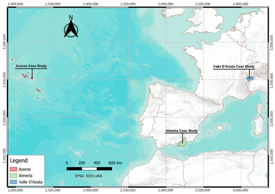
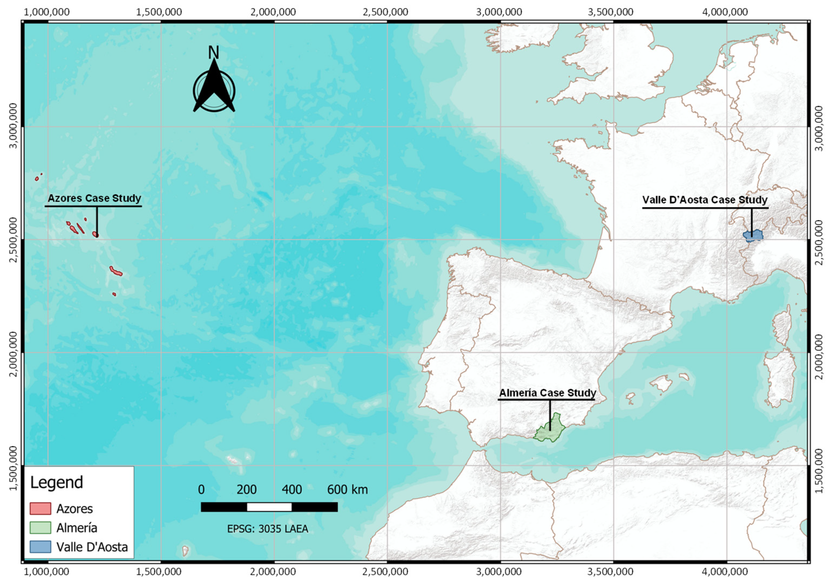
To conduct the suitability analysis for deploying land-use-based adaptation and mitigation solutions (LAMS) focused on renewable energy, using Python-based algorithms, three out of six case studies from the European RethinkAction project [31] were selected. The chosen case studies were: Valle D’Aosta (Italy) (3261 km2), Almería (Spain) (8778 km2), and the Azores (Portugal) (2322 km2). Figure 1 shows the location of the three selected case studies across Europe. These three case studies were selected to reflect a diversity of geographic, climatic, and socioeconomic conditions that influence the feasibility and impact of deploying LAMSs focused on renewable energy. Almería represents a semi-arid Mediterranean region under pressure from intensive agriculture and water scarcity. Valle D’Aosta provides a mountainous Alpine context, where renewable energy intersects with tourism, conservation, and demographic challenges. The Azores, as an insular and remote territory, offers a unique testing ground for decentralized renewable energy systems and resilient land-use strategies. This diversity allows for a comprehensive evaluation of spatial suitability across contrasting European landscapes.
Figure 1.
Location of the three selected case studies across Europe: the Azores (Portugal), Almería (Spain), and Valle D’Aosta (Italy).
2.2. LAMS Definition
The LAMSs defined in this section were extracted from the LAMS catalogue developed within the European RethinkAction project [32]. The catalogue contains 62 solutions, each accompanied by detailed descriptions and analyses of their characteristics. For this paper, the selected solutions are listed and described in Table 1. They belong to the energy sector and focus on solar installations, which were selected for their high relevance to regional renewable energy deployment strategies.
Table 1.
Definition of the selected energy LAMS from the LAMS catalogue.
2.3. Data Sources
The quantification of the suitable area for the deployment of energy LAMSs requires the identification of suitability factors (technical, environmental and economic) that impact the suitability of each specific LAMS, as well as data, to develop the criteria in a geo-located format. Table 2 shows the identified criteria selected for each specific LAMS, along with the data source used for the quantification of the criteria.
Table 2.
Selected suitability factors as raster layers to evaluate suitability areas for energy LAMS: (1) spatial planning for the sustainable deployment of energy on land, (2) agrovoltaic farms, (3) photovoltaic plants, (4) floating solar photovoltaic panels in water bodies, (5) solar panels on rooftops/buildings, (6) land management of solar photovoltaic systems land. ✓ represents that the factor is used in each LAMS.
2.4. Identification of Suitability Factors
The modeling methodology for evaluating the suitability of land for the deployment of LAMSs requires the selection of different suitability criteria, differentiating between two categories of suitability criteria as follows. (i) The restrictions or constraints that determine whether land is suitable or not suitable for a given solution. It works as a limiting conditions that prevent the deployment of LAMS, such as legal restrictions or biophysical barriers. And (ii) the conditions that define the degree of suitability within areas already considered suitable. They influence the likelihood of implementing a solution by accounting for competing land uses and the relative advantages of each option.
Based on these principles, four main types of suitability factors have been identified: (i) geographical factors like topography, slope, aspect, parcel size, land cover or climate conditions; (ii) regulatory factors including legal or planning restrictions such as protected areas, biodiversity conservation zones, or urban classifications; (iii) techno-economic factors such as infrastructure availability, costs of construction, operation and maintenance, distance to settlements, or resource potential (e.g., solar irradiance, water availability); and (iv) sustainability factors that integrate broader environmental, social, and economic considerations. These include potential impacts on biodiversity, pollution, food security, climate emissions, and social acceptance (e.g., noise, health, equity).
These suitability factors serve not only to exclude unsuitable areas, but also help to differentiate levels of suitability, enabling more informed decisions on land allocation. This ensures that LAMS deployment aligns with environmental sustainability, social acceptance, and economic feasibility goals. Table 3, Table 4, Table 5, Table 6, Table 7 and Table 8 show the suitability factors identified for each LAMS according to the criteria established for their definition. In addition, the thresholds used according to each LAMS in order to generate the specific suitability map for each solution are provided. The thresholds were derived from a combination of peer-reviewed literature on solar suitability assessment, the technical and land-use specifications associated with each LAMS, and operational criteria adopted within the RethinkAction project to ensure methodological consistency across the project case studies. According to that, the threshold definition followed a harmonized approach instead of a purely local definition, with the aim of making results comparable across different territorial contexts. This means that these thresholds cannot be considered as universal optimal values, as suitability and discriminatory capacity could change depending on regulatory or land-use conditions of each case study. This is particularly relevant for factors such as those based on distances, whose practical implications are context-sensitive due to regulation constraints, highlighting that the proposed thresholds are defined as standard values useful as part of a replicable GIS-MCDM assessment. New values could be requested when the methodology is applied in other territorial contexts
Table 3.
Thresholds used for layer reclassification in LAMS 1, spatial planning for the sustainable deployment of energy on land.
Table 4.
Thresholds used for layer reclassification in LAMS 2, agrovoltaic farms.
Table 5.
Thresholds used for layer reclassification in LAMS 3, photovoltaic plants.
Table 6.
Thresholds used for layer reclassification in LAMS 4, floating solar photovoltaic panels in water bodies.
Table 7.
Thresholds used for layer reclassification in LAMS 5, solar panels on rooftops/buildings.
Table 8.
Thresholds used for layer reclassification in LAMS 6, land management of solar photovoltaic systems land.
2.5. Methodology for Maps Development
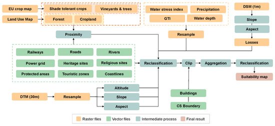
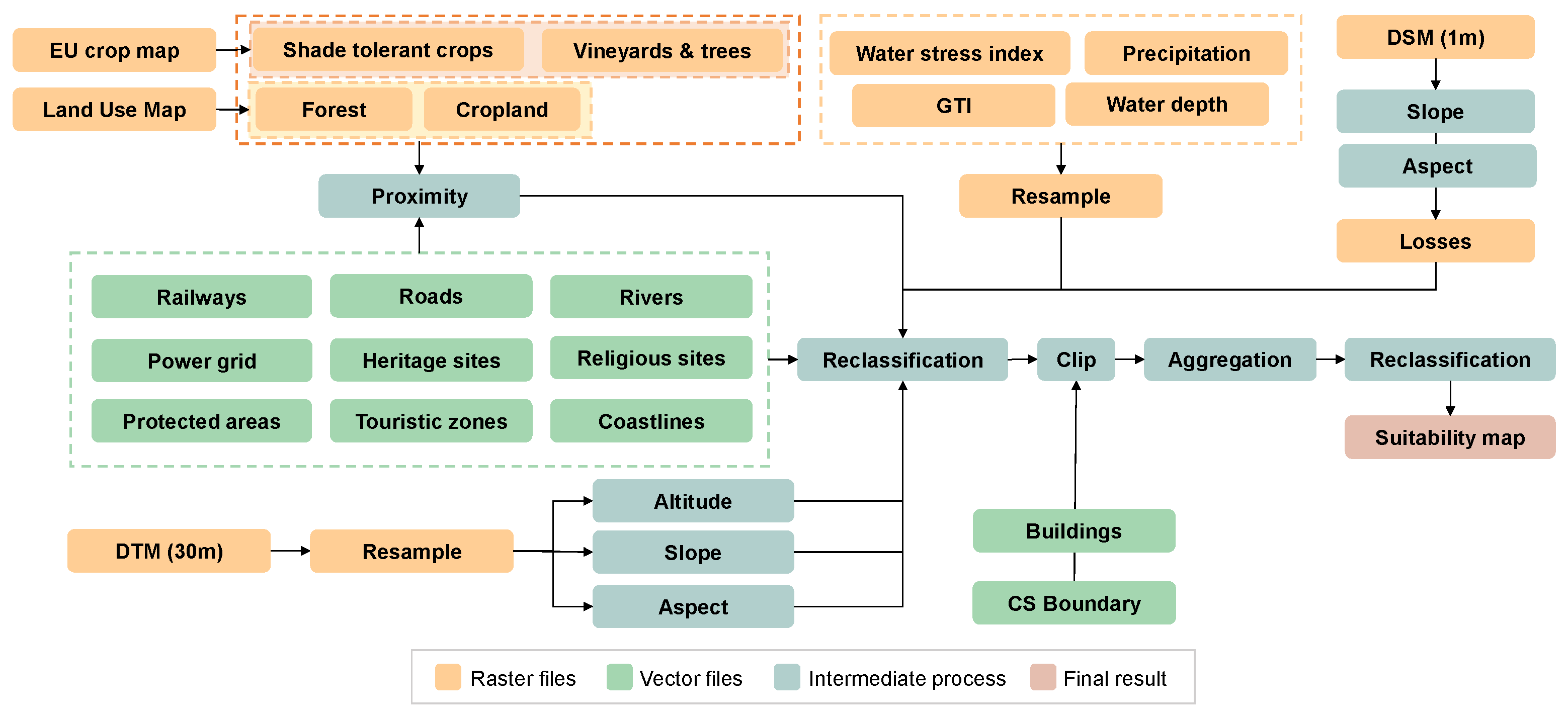
The methodology for the production of suitability maps related to land-based energy solutions integrates data from different types of data formats (raster or vector) and from different spatial resolutions to develop high-resolution maps (10 m) for each of the energy-based measures that require land for their installation. The modeling methodology is presented in Figure 2.
Figure 2.
Methodology for the implementation of suitability maps for energy LAMS. Different colors in boxes are aligned with the legend included in the figure.
The process began with collecting the required raster and vector datasets. Raster inputs include agricultural information from the EU crop map, land-use data, and data representing shade-tolerant crops, forest, cropland, vineyards and trees. In parallel, environmental factors such as water stress index, Global Tilted Irradiance (GTI), precipitation and water depth were also incorporated as raster datasets. Topographical information was obtained from Digital Surface Models (DSMs) and Digital Terrain Models (DTMs) at different resolutions (10 m and 30 m, respectively). The DTM, with a spatial resolution of 30 m, was resampled to 10 m to align with other layers. From this resampled terrain model, altitude, slope and aspect maps were derived to capture the landscape’s physical characteristics. Other raster data, such as water stress, GTI, precipitation and water depth, were also resampled as part of the spatial resolution harmonization process.
Simultaneously, vector layers such as railways, roads, rivers, power grids, heritage sites, religious sites, protected areas, tourist zones and coastlines were processed to generate proximity maps in raster format at 10 m spatial resolution. These proximity maps quantify the distance from each location to key infrastructure or natural resource features, providing critical inputs for the implementation of suitability analysis.
Once all basic layers had been prepared, a reclassification step standardized the datasets into comparable suitability scores (see Table 9 with the reclassification scores per layer and Table 3, Table 4, Table 5, Table 6, Table 7 and Table 8 for the thresholds used according to each LAMS in order to generate the specific suitability map for each solution). The layers were then clipped using the case study (CS) boundary. After that, the raster data were aggregated, combining the reclassified layers using equal weights for each layer to compute the final suitability value, obtaining their contribution across the suitability landscape. Equal weights have been considered to avoid the introduction of subjective or arbitrary biases by the analyst. In this sense, equal weights define a conservative scenario to identify potential suitability for the measures. After the aggregation process, which produced mean suitability values, a final reclassification step was performed to simplify the interpretation of the results. This structured and multi-step process resulted in the creation of suitability maps, which identify the most favorable areas according to the integrated biophysical, infrastructural, and environmental conditions.
Table 9.
Datasets used for the suitability maps and reclassification criteria.
As part of the rooftop suitability for solar photovoltaic, the DSM was processed following a different path in order to extract slope, aspect, and expected production losses, which were later incorporated into the reclassification process. Information about buildings, such as their boundaries, was integrated into the suitability definition process to exclude or penalize unsuitable areas at the building level. Rooftop solar was not calculated in the Azores due to a lack of LiDAR data to develop a rooftop suitability analysis with high resolution (1–2 m) that was requested for this suitability analysis.
2.6. Code Implementation
The methodology developed in the previous section for the creation of suitability maps through the integration of economic, technical, and environmental criteria that allow the assessment of land suitability for the deployment of a land-use-based energy solution was implemented in Python 3.12. The implementation used specialized libraries for geospatial data processing and analysis, such as Rasterio and Geopandas. These libraries were combined with other libraries, such as Pandas and Numpy, for managing alphanumeric data.
The developed code was structured into independent modules (one per suitability map) to ensure the reproducibility and scalability of the analysis. Each of the developed modules enables the automated generation of a suitability map by integrating the considerations defined in the Methodology (Section 2.4). Each algorithm performs the analysis in a stepwise manner, saving intermediate results to maintain full control over the obtained outputs. Additionally, data projection is automatically controlled, maintained and corrected, and the spatial alignment of the raster files is ensured by defining reference coordinates for each of the files involved in the process of suitability map implementation. This strategy ensures accurate results for each energy solution in each case study.
2.7. Suitability Area by Land Use
Once the suitability map for each LAMS had been developed, the degree of suitability of each measure was evaluated according to each land-use type. High-resolution land-use maps for each case study [33] were used and overlaid with the suitability map developed for each measure using QGIS software version 3.40.8 and the Zonal Statistics tool for working with raster layers. To apply this tool, it was first necessary to extract the different suitability classes (using a mask for each specific suitability value: not suitable = 0, least suitable = 1, moderately suitable = 2, suitable = 3) in order to obtain the requested values for each specific land-use type.
3. Results
The proposed GIS-based MCDM methodology was applied to Valle D’Aosta (Italy), Almería (Spain), and the Azores (Portugal) in order to assess the spatial level of suitability of six different land-use-based adaptation and mitigation solutions (LAMS). For each case study, a suitability map was generated for each energy LAMS using high-resolution spatial layers covering the main drivers that affect the measure deployment and equal weights for each layer to compute the final suitability values. The developed analysis classified land into four suitability categories (not suitable, least suitable, moderately suitable and suitable) based on the integration of the technical, environmental, and socioeconomic criteria that affect the suitability of each LAMS.
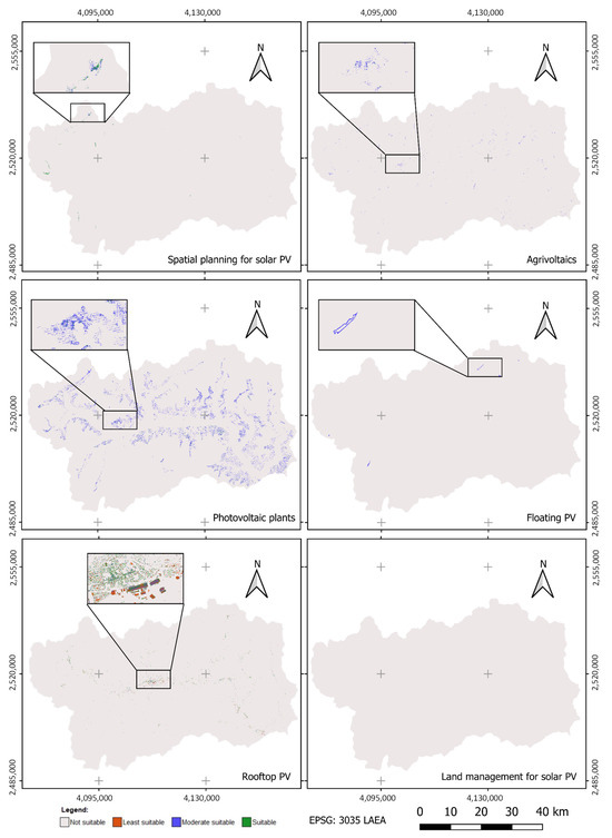
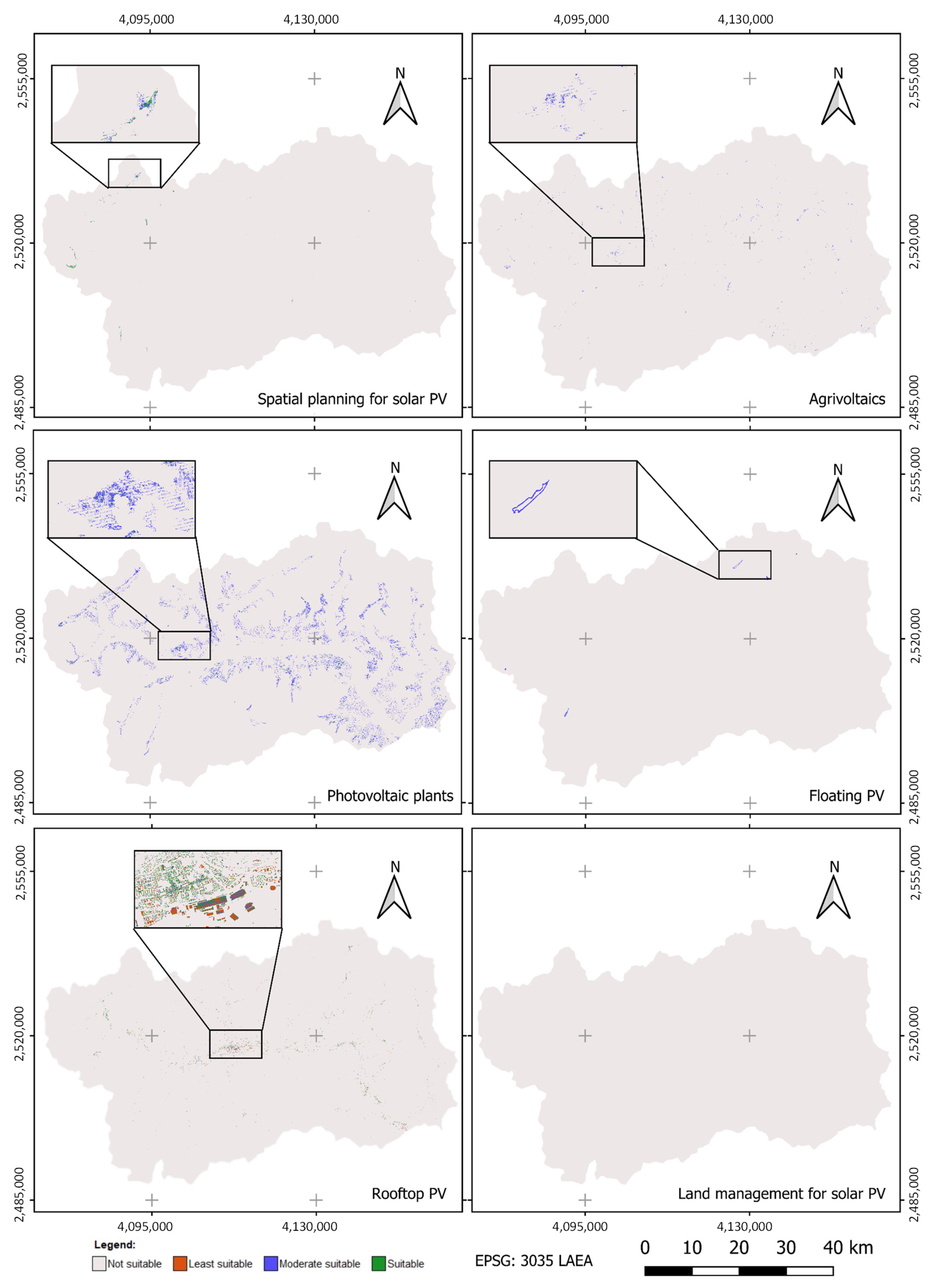
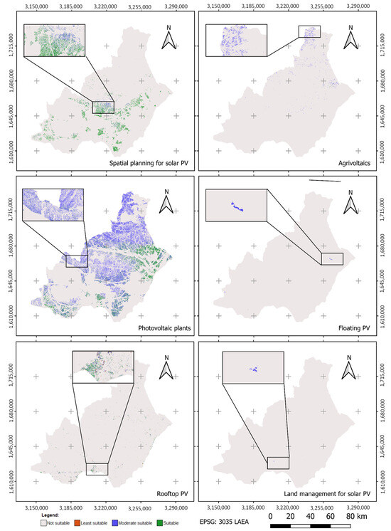
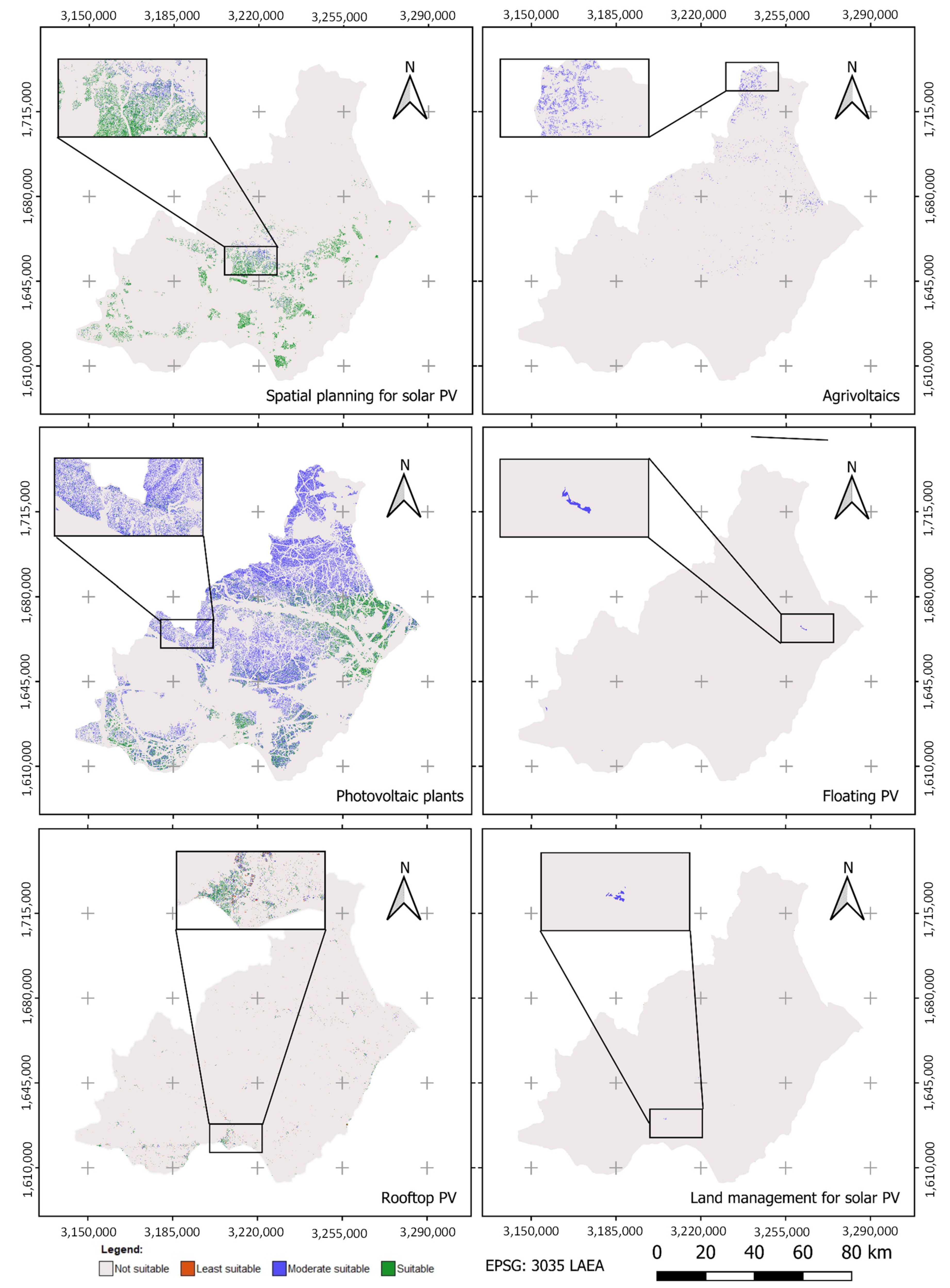
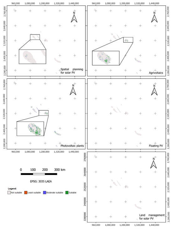
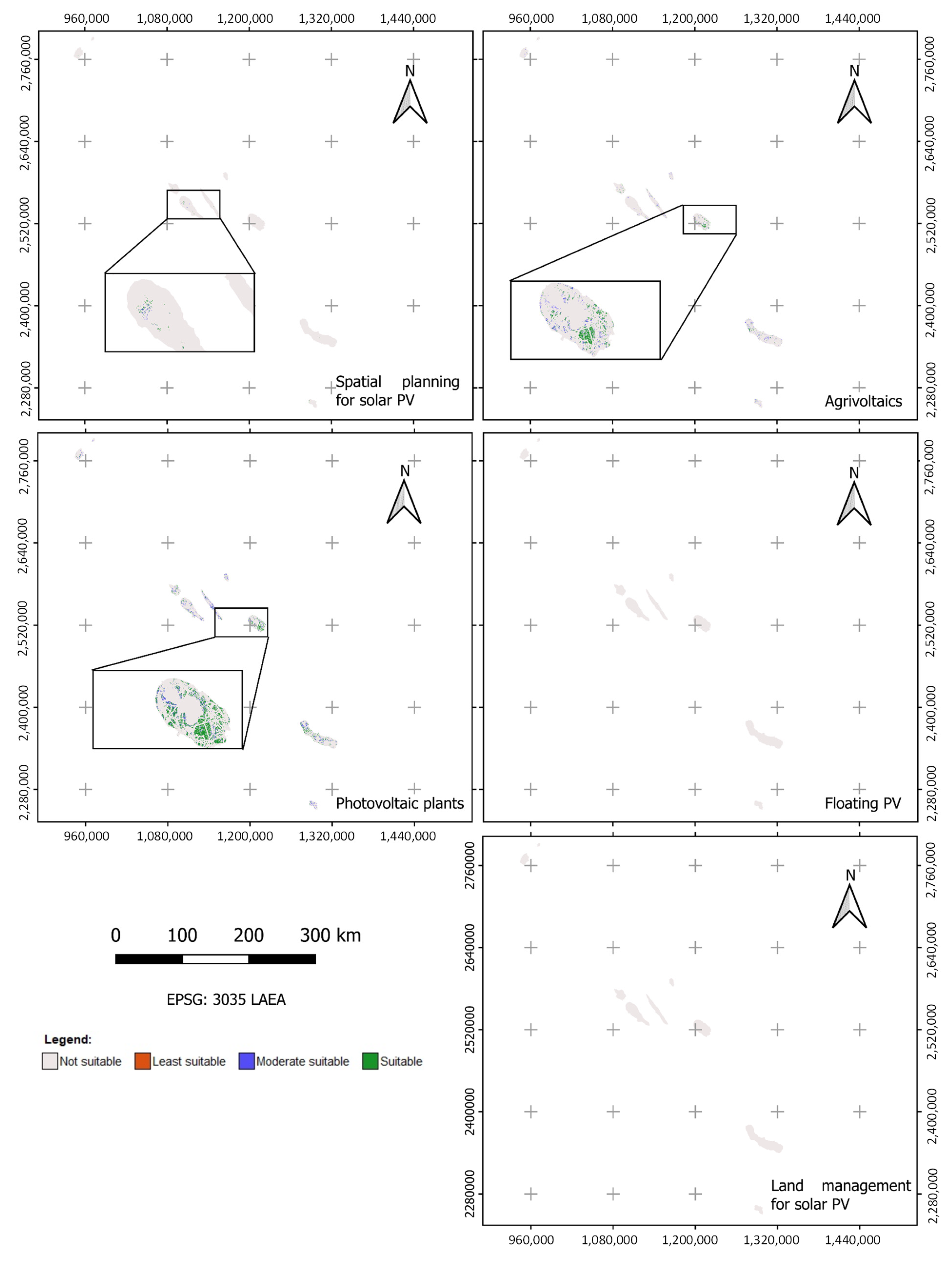
The suitability maps have been generated as raster files per case study and are represented in Figure 3, Figure 4 and Figure 5, to provide a visual representation of the suitability location by class for each case study. The suitability values by land use, obtained from the superposition of the suitability maps and the land use map, can be seen in Appendix A.
Figure 3.
Suitability maps for the six energy LAMSs for Valle D’Aosta.
Figure 4.
Suitability maps for the six energy LAMSs for Almería.
Figure 5.
Suitability maps for five of the six energy LAMSs for the Azores. Rooftop solar was not assessed due to insufficient LiDAR data for the suitability analysis.
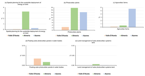
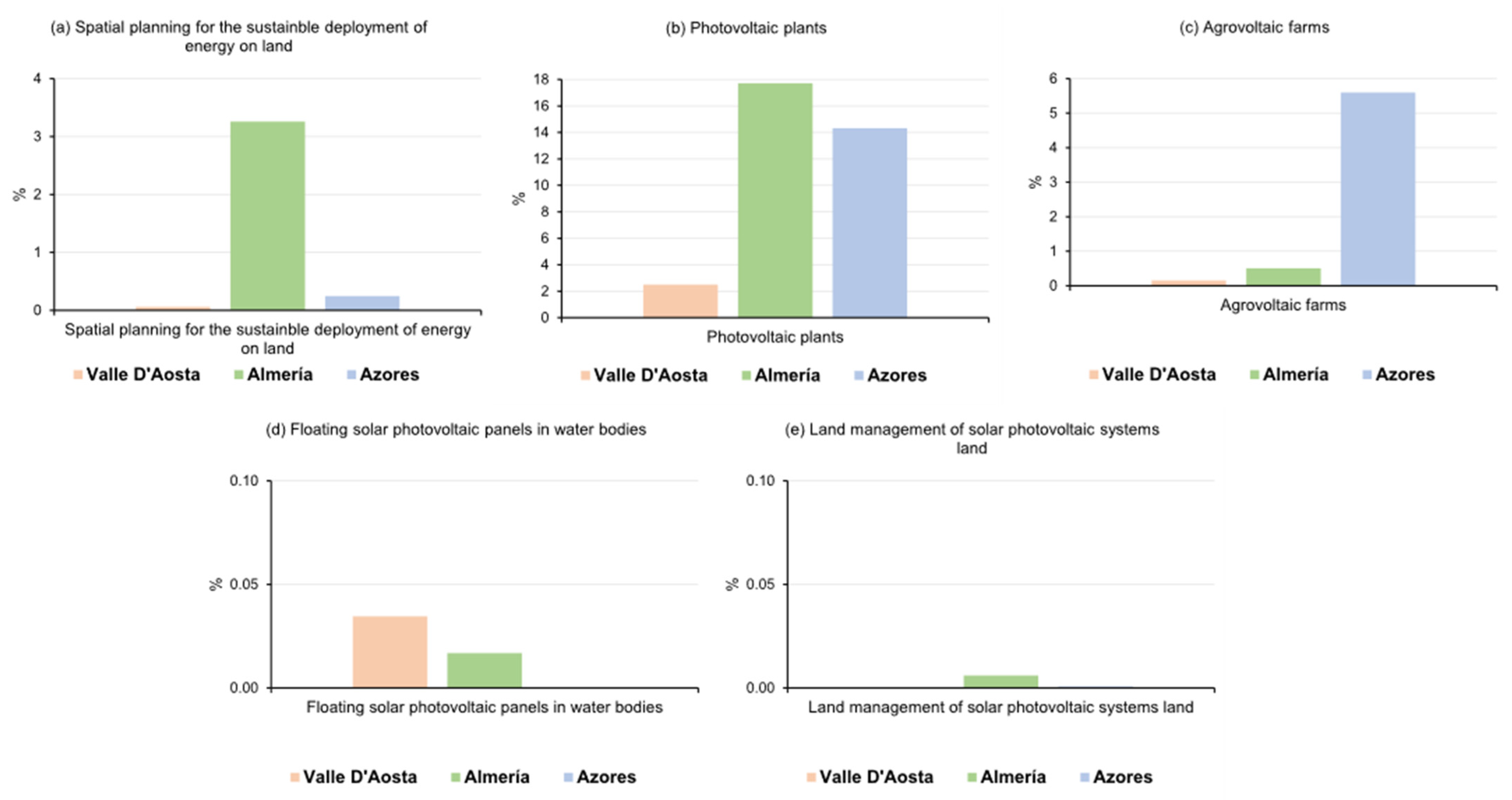
Figure 6 shows the percentage of land classified as most suitable for five of the six measures in the three territories. The rooftop suitability is analyzed independently (Figure 7) since it is based solely on the built-up area. A clear trend emerges from this suitability analysis: Almería and the Azores offer substantially greater land availability for highly suitable deployment than Valle d’Aosta, which shows extremely limited suitability across nearly all the evaluated measures. Specifically, photovoltaic plants stand out as the most viable measure in both Almería (≈17%) and the Azores (≈14%), with Valle d’Aosta trailing far behind (<1%). Agrovoltaic farms show relevant potential in the Azores (~6%) and minimal values in the other two locations. The spatial planning LAMS shows moderate suitability only in Almería (~3%), whereas floating solar PV and solar land management are found generally unsuitable in the three territories.
Figure 6.
Suitable area in percentage by LAMS and case study.
Figure 7.
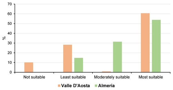
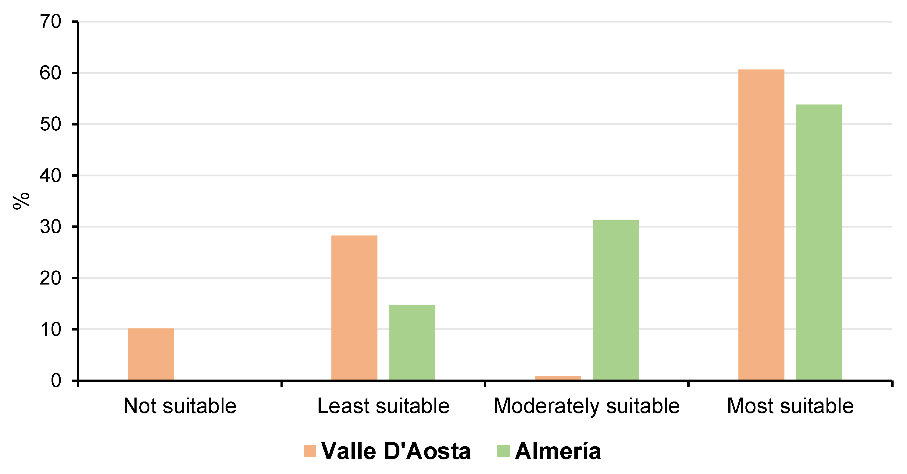
Suitability class per case study for Valle D’Aosta and Almería for solar panels on rooftops/buildings.
These results are reinforced by the absolute surface areas presented in Table 10, which indicate that Almería accumulates the highest values in terms of hectares classified as most suitable, particularly for photovoltaic plants (40,421 ha) and rooftop solar (42,227 ha). The Azores also display considerable values in photovoltaic plants (17,761 ha) and agrovoltaic farms (5653 ha), while Valle d’Aosta presents extremely low values (except in rooftop solar), where it reaches 15,077 ha of highly suitable area. It is necessary to highlight that rooftop solar was not calculated in the Azores due to a lack of LiDAR data to develop a rooftop suitability analysis with high resolution (one or two meters), which is requested for this suitability analysis.
Table 10.
Suitable area in hectares by energy LAMS and case study.
The rooftop suitability pattern is explored in more detail in Figure 7, which compares the full suitability class distribution for rooftop solar systems in Valle d’Aosta and Almería. Despite both regions having a large share of rooftop area in the most suitable category (over 60% in Valle d’Aosta and over 50% in Almería), Valle d’Aosta also exhibits significantly higher proportions in the least and not suitable classes. This suggests a spatial heterogeneity in roof availability due to building aspect and rooftop slope, which are the two components that generate a high impact on the losses of an installation. Furthermore, because Almería has a higher level of available solar radiation compared to Valle d’Aosta, any roof, even a flat one, is suitable for photovoltaic production.
If we analyze all the measures as a whole, Almería shows a broader spread of high suitability across several measures (spatial planning for the sustainable deployment of energy on land, photovoltaic plants and agrovoltaic farms), due to a combination of favorable topography, high solar radiation conditions, as well as good infrastructure and access conditions. This makes the region flexible and technically ready for diverse solar energy LAMS implementation. The Azores islands, while more fragmented, still provide a really good opportunity for hybrid and decentralized systems such as photovoltaic plants or agrovoltaic farms, strategies particularly relevant for insular territories aiming for resilience and self-sufficiency. Finally, Valle d’Aosta is characterized by a complex landscape typical of mountain regions. It also has a strict land-use regulation with protected areas. Therefore, the most suitable solution to be considered in this region is solar panels on rooftops, followed by photovoltaic plants. Most land in this region is simply not compatible with surface-based solar deployment strategies, thus confirming the need for territorially adapted approaches to energy planning.
Together, the quantitative surface data (Table 10) and visual summaries (Figure 6 and Figure 7) show marked differences in the spatial suitability of solar LAMSs across the three case studies. These differences are reflected not only in the total suitable area, but also in the land-use classes associated with each measure. The results are described and compared below by case study and LAMS typology, considering also the land uses classified as suitable or unsuitable for each measure.
First, Spatial planning for the sustainable deployment of energy on land shows extremely limited suitability in Valle d’Aosta and the Azores, with over 99% of the land classified as not suitable. In Valle d’Aosta, only 153 ha are identified as most suitable, mostly located in shrubland and grassland areas. In contrast, Almería exhibits a more favorable scenario, with 25,513 ha in the most suitable class. In this case, these areas are concentrated in shrubland, grasslands, and other lands. By comparison, forest and cropland areas in the three case studies were consistently classified as not suitable. Similarly, the Azores show only marginal suitability (369 ha), also restricted to shrubland and grassland.
Regarding agrovoltaics, the Azores case study shows the highest suitability, with 5653 ha classified as most suitable and 7238 ha as moderately suitable, primarily in rainfed cropland and shrubland. By contrast, total suitability in Almería is lower, with 132 ha classified as most suitable, mainly in irrigated croplands and shrublands. On the other hand, Valle d’Aosta shows only marginal suitability, with 9 ha classified as most suitable. Overall, the most suitable areas are associated with agricultural land uses located on not very steep slopes and under favorable solar conditions.
Photovoltaic plants represent the largest suitable area in Almería, with 40,421 ha classified as most suitable and 115,065 ha as moderately suitable. In this case, suitable land is distributed across shrubland, cropland, and managed forest areas. Likewise, the Azores also show relatively high suitability, with 17,761 ha classified as most suitable, mainly in rainfed cropland, grasslands, and shrubland. In contrast, Valle d’Aosta shows a much more limited pattern, with only 709 ha classified as most suitable, and with a focus on land covers such as shrubland.
In the case of floating solar solutions, the three evaluated case studies show very limited to no suitability. Only Almería presents 148 ha classified as moderately suitable in water bodies. Meanwhile, Valle d’Aosta and the Azores show no suitable water bodies. Although 113 ha in Valle d’Aosta are classified as moderately suitable, this area could be subject to water level fluctuations, making it less than ideal.
To continue, the solar panels on rooftops/buildings measure has a different distribution among the case studies. In Valle d’Aosta, there is the only measure that reaches particularly high suitability values, with 15,077 ha classified as most suitable and with a focus on urban land uses. Almería also shows high suitability values, with 42,227 ha classified as most suitable. In the opposite part are the results for the Azores case study, where data are unavailable due to the lack of LiDAR data required to apply the same quantification approach as in the other two case studies.
Finally, land management of solar photovoltaic systems is almost entirely classified as not suitable in the three evaluated case studies, with only 52.3 ha in Almería and 2 ha in the Azores showing very low suitability. Valle d’Aosta shows no suitable area for this measure. These low values are associated with the lack of detailed data on land occupied by existing solar installations, which limits the suitability evaluation for this measure using the high-resolution land-use map (10 m of spatial resolution) provided by the RethinkAction project.
4. Discussion
The spatial differentiation observed in the suitability of LAMSs across Valle d’Aosta, Almería, and the Azores reinforces the increasing consensus that energy transition strategies must be tailored to local contexts in order to promote acceptance and facilitate the deployment [4,34,35]. Obtained results could support a shift from one-size-fits-all energy strategies towards differentiated and place-based planning approaches [34]. The governance and regulatory conditions of each territory really shape which LAMSs could be implemented and at what scale. Therefore, suitability maps should not be interpreted only as a descriptive output, but also as an operational result to support decision-making to prioritize different land-use deployment pathways. They can help guide planning and investment decisions by identifying spatially explicit priorities and constraints that are often not visible when only techno-economic considerations are considered [36]. In this regard, the outstanding suitability of photovoltaic plants in Almería, with over 40,000 ha deemed most suitable, is consistent with previous findings in the Mediterranean region as well as other semi-arid zones, where high solar irradiance, terrain with low slopes, and sparse vegetation enable broad deployment of solar infrastructure [5,9,37]. However, these maps only show suitable areas for photovoltaic plants. A comprehensive assessment must also account for competition with other land uses, such as agriculture. This could have direct implications for governance. For example, in Almería, the main planning challenge is not only where PV expansion is technically feasible, but how to ensure that it is aligned with intensive agriculture in a water-stressed landscape, covering broader land-use planning objectives. This points out that regional authorities could use the results to identify low-conflict areas, avoid the occupation of highly valuable agricultural land, and support more coherent integration between energy policy and territorial planning instruments. In addition, and for a proper integration of energy and land-use planning policies, the implementation of energy LAMSs should ideally be limited to the spatial planning LAMS, which includes sustainable conditions that minimize environmental and socioeconomic impacts. In this sense, Almería is also the most promising area for incorporating these sustainable conditions.
The limited suitability of photovoltaic plants in Valle d’Aosta, particularly for ground-mounted and land-intensive systems, reflects the challenges of mountainous, highly protected environments, where steep slopes and land-use restrictions severely constrain deployment. In this case, the results are especially relevant from a regulatory and policy perspective, as they indicate that conventional land-based solar expansion is likely to face strong constraints from environmental protection regimes, landscape preservation, and existing land-use regulation. This illustrates how land-cover heterogeneity and policy constraints jointly determine the spatial potential of different LAMSs [38]. Rooftop-based solutions emerge as the most effective, as was highlighted by [39], who advocate for the prioritization of building-integrated photovoltaics solutions in compact and topographically constrained regions. Planners and decision-makers in Valle d’Aosta need to pay attention to policies towards rooftop and building-integrated systems, while reducing investment and administrative effort in land-intensive options with limited territorial feasibility.
The positive suitability results for Agrovoltaic farms in the Azores, with special mention to rainfed cropland, are aligned with the growing trend in the literature of supporting land-sharing approaches, where dual use of land for agriculture and solar energy enhances overall land-use efficiency and combined food and energy production [40,41]. The measure allows the co-location of food and energy production, crucial in areas where land is scarce or fragmented [42]. From a governance perspective, this measure is particularly relevant in insular environments, where land availability is limited and energy resilience is a strategic priority. Agrovoltaics could be a pathway to reconcile renewable energy deployment with multifunctional rural land management, reducing conflicts between energy generation and agricultural activity. Although other cases like Almería show more limited spatial potential due to the type of the agricultural system, small-scale agrovoltaic deployment may still contribute to diversified energy production in, for example, irrigated areas. Overall, these results support the relevance of land-sharing strategies in contexts where agricultural continuity and renewable energy deployment need to be pursued simultaneously. This highlights the role of our methodology as an appropriate tool for the selection of the most relevant policy instrument according to the priorities of each territory.
Regarding floating solar PV systems, the analysis shows negligible suitability across the three case studies. This outcome is in line with the literature that points out the technical, ecological, and hydrological constraints of such systems related to the need for large, calm water bodies, absence of shading, and minimal conflict with biodiversity goals [5,43]. In this sense, their potential is limited to very specific locations, often requiring significant policy and ownership coordination among the different governance levels for a successful implementation. This reinforces the idea that floating PV remains a niche solution, feasible only under specific hydrological conditions and adequate institutional coordination. All of this makes this solution a good alternative, but complementary to the previous solutions (and not valid if applied on its own) for achieving a truly integrated energy and land-use policy where solar panels are deployed on land, avoiding the competition with other productive land uses.
Analyzing the land management of solar photovoltaic systems solutions measures, it was largely classified as unsuitable in the evaluated case studies due to limited data on solar facilities and incompatibilities with current and previous land use, as well as land regulations. This reflects the structural barriers identified in several European contexts, where rigid classifications and competing interests between agriculture, conservation, and infrastructure limit the capacity to allocate land for long-term solar occupation [44]. Without active policy adaptation or cross-sectoral governance mechanisms, this LAMS remains more theoretical than feasible in practice, reflecting the institutional, regulatory, and data-related limitations that affect PV deployment. As a result, more developed policy and regulatory frameworks capable of enabling new land management paradigms for renewable energy purposes, especially in agricultural and forest-dominated landscapes, are requested.
The implemented analysis underscores the utility of GIS-based MCDM approaches in revealing these territorial nuances and supporting evidence-based planning [2,13,22]. By combining technical, environmental, and socioeconomic criteria, this method proves to be robust in identifying feasible and conflict-sensitive areas for LAMS implementation. The practical value of the proposed methodology lies in its ability to translate complex technical, environmental, and regulatory information into spatially explicit outputs that can be directly used for preliminary screening, land allocation, conflict avoidance, and strategic prioritization. It could provide support in deciding which LAMSs are more appropriate in each location before moving to implementation. These findings advocate for the territorialization of energy policy, emphasizing that no single solution fits all contexts and that place-based strategies are essential for sustainable and socially acceptable energy transitions, emphasizing the operational role of the methodology as a transparent and transferable basis for energy planning in different areas.
5. Conclusions
This study demonstrates the effectiveness of the implemented Python-based GIS-MCDM methodology for identifying spatially suitable areas for solar energy deployment through LAMS. The applied MCDM methodology, built as an operational extension of GIS-MCDM for land-use-sensitive, multi-measure energy planning, has produced highly heterogeneous results in terms of the available areas for each of the solutions, giving us an indication of the essential role played by territorial characteristics and the methodological constraints established by each of the variables used to determine land-use availability for integrating different energy solutions. It should also be noted that all drivers or factors integrated into the MCDM methodology were assigned an equal weight, which minimizes the influence of specific variables on the final suitability value.
Spatial variability was significant among the three case studies. While Almería shows broad suitability for multiple LAMSs due to its high solar irradiation and available land across land-use categories, the Azores present localized opportunities for photovoltaic plants and agrovoltaic farms. On the other hand, Valle d’Aosta faces significant constraints for LAMS deployment, with rooftop- and building-mounted solar representing the most viable option. The topography, the level of land protection and the available solar radiation are the main drivers affecting this LAMS’ suitability. Floating solar and solar land management have been identified with limited feasibility in the three evaluated case studies. These solutions are constrained by natural resource availability (size and level of water bodies) and institutional barriers like zoning or land-use data on the area occupied by photovoltaic plants, pointing to the need for geo-located data with high-resolution, as well as a consistent regulatory development that ensures potential problems.
In this sense, it can be highlighted that suitability is clearly land-use dependent. The restrictions applied to each land-use type result in the most suitable areas being located in shrublands, grasslands, and croplands, while forests and areas under protection (e.g., the Natura 2000 Network) are classified as unsuitable. Defining these limitations is essential to ensure that the suitability results are consistent and coherent. This approach reinforces the need to consider land-use heterogeneity and zoning regulations when planning sustainable energy transitions.
The integration of spatially explicit criteria within a transparent and replicable methodology supports strategic, context-sensitive energy planning and aligns with the goals of sustainable land-use management, capable of integrating social and environmental factors. Differentiated, place-based approaches in land-use-based renewable energy deployment solutions are key, highlighting the need for supportive data infrastructures and policy frameworks to facilitate the implementation of energy solutions that require land for deployment. The methodology described in this paper provides harmonized spatial information for policy makers, planners, and other relevant stakeholders, supporting more transparent communication and participatory processes related to renewable energy planning and social acceptance.
Author Contributions
Conceptualization, Iván Ramos-Diez; methodology, Iván Ramos-Diez, Jonas Ljunggren and Noelia Ferreras-Alonso; software, Iván Ramos-Diez; validation, Iván Ramos-Diez; investigation, Iván Ramos-Diez, Sara Barilari, Jonas Ljunggren, Sofie Hellsten and Noelia Ferreras-Alonso; writ-ing—original draft preparation, Iván Ramos-Diez and Sara Barilari; writing—review and editing, Iván Ramos-Diez, Sara Barilari, Jonas Ljunggren, Noelia Ferreras-Alonso and Sofie Hellsten; visualization, Iván Ramos-Diez All authors have read and agreed to the published version of the manuscript.
Funding
This work was supported by the Horizon 2020 European project “RethinkAction”, under Grant Agreement No. 101037104.
Data Availability Statement
The suitability raster files and the LAMS catalogue used in this article are available in the RethinkAction project repository in Zenodo (https://zenodo.org/communities/rethinkaction/records?q=&l=list&p=1&s=10 (accessed on 29 March 2026)).The Python code is protected by copyright and is part of a confidential deliverable of the RethinkAction project. You can contact the authors for more information.
Acknowledgments
The authors would like to thank Yaiza Villar-Jiménez for her support with the suitability maps implementation and Patricia Pérez Ramirez (GMV) for the geo-located data collection at the case study level.
Conflicts of Interest
The authors declare no conflicts of interest.
Abbreviations
The following abbreviations are used in this manuscript:
| MCDM | Multi-Criteria Decision-Making |
| LAMS | Land-Use-Based Adaptation and Mitigation Solutions |
| GIS | Geographical Information Systems |
| PV | Photovoltaic |
| AHP | Analytical Hierarchical Process |
| FAIR | Findable, Accessible, Interoperable, and Reusable |
| EU | European Union |
| GTI | Global Tilted Irradiance |
| DSMs | Digital Surface Models |
| DTMs | Digital Terrain Models |
| CS | Case Study |
| LiDAR | Light Detection and Ranging |
Appendix A
Table A1 presents the suitability areas per land use at the case study level.
Table A1.
Suitability area in hectares by land use and LAMS per case study.
References
- Gebreabe, S.T.; Bogale, D.; Hailu, A.; Worku, A. Advances in solar energy technologies: A comprehensive review of photovoltaic, thermal, and hybrid systems for sustainable energy solutions. Next Res. 2026, 3, 101176. [Google Scholar] [CrossRef] [Scilit]
- Onuoha, H.; Denwigwe, I.; Babatunde, O.; Abdulsalam, K.A.; Adebisi, J.; Emezirinwune, M.; Okharedia, T.; Akindayomi, A.; Adisa, K.; Hamam, Y. Integrating GIS and AHP for Photovoltaic Farm Site Selection: A Case Study of Ikorodu, Nigeria. Processes 2025, 13, 164. [Google Scholar] [CrossRef] [Scilit]
- Rumbayan, M.; Kindangen, J.; Sambul, A.; Sompie, S.; Cross, J. Solar energy implementation in rural communities and its contributions to SDGs: A systematic literature review. Unconv. Resour. 2025, 6, 100180. [Google Scholar] [CrossRef] [Scilit]
- Nasir, M.; Iqbal, S.; Khan, H.A.; Vasquez, J.C.; Guerrero, J.M. Sustainable Rural Electrification Through Solar PV DC Microgrids—An Architecture-Based Assessment. Processes 2020, 8, 1417. [Google Scholar] [CrossRef] [Scilit]
- Tölgyesi, C.; Bátori, Z.; Pascarella, J.; Erdős, L.; Török, P.; Batáry, P.; Birkhofer, K.; Scherer, L.; Michalko, R.; Košulič, O.; et al. Ecovoltaics: Framework and future research directions to reconcile land-based solar power development with ecosystem conservation. Biol. Conserv. 2023, 285, 110242. [Google Scholar] [CrossRef] [Scilit]
- Sekeroglu, A.; Erol, D. Site selection modeling of hybrid renewable energy facilities using suitability index in spatial planning. Renew. Energy 2023, 219, 119458. [Google Scholar] [CrossRef] [Scilit]
- Shao, M.; Han, Z.; Sun, J.; Xiao, C.; Zhang, S.; Zhao, Y. A review of multi-criteria decision making applications for renewable energy site selection. Renew. Energy 2020, 157, 377–403. [Google Scholar] [CrossRef] [Scilit]
- Ferreras-Alonso, N.; Capellan-Pérez, I.; Adam, A.; de Blas, I.; Mediavilla, M. Mitigation of land-related impacts of solar deployment in the European Union through land planning policies. Energy 2024, 302, 131617. [Google Scholar] [CrossRef] [Scilit]
- Pramanik, M.K. Site suitability analysis for agricultural land use of Darjeeling district using AHP and GIS techniques. Model. Earth Syst. Environ. 2016, 2, 56. [Google Scholar] [CrossRef] [Scilit]
- Nassar, A.K.; Al-Dulaimi, O.; Fakhruldeen, H.F.; Sapaev, I.B.; Jabbar, F.I.; Dawood, I.I.; Khalaf, D.H.; Algburi, S. Multi-criteria GIS-based approach for optimal site selection of solar and wind energy. Unconv. Resour. 2025, 7, 100192. [Google Scholar] [CrossRef] [Scilit]
- Gebre, S.L.; Cattrysse, D.; Alemayehu, E.; Van Orshoven, J. Multi-criteria decision making methods to address rural land allocation problems: A systematic review. Int. Soil Water Conserv. Res. 2021, 9, 490–501. [Google Scholar] [CrossRef] [Scilit]
- Hasti, F.; Mamkhezri, J.; McFerrin, R.; Pezhooli, N. Optimal Solar Photovoltaic Site Selection Using Geographic Information System–Based Modeling Techniques and Assessing Environmental and Economic Impacts: The Case of Kurdistan. Sol. Energy 2023, 262, 111807. [Google Scholar] [CrossRef] [Scilit]
- Cook, D.; Pétursson, J.G. The role of GIS mapping in multi-criteria decision analysis in informing the location and design of renewable energy projects—A systematic review. Energy Strat. Rev. 2025, 59, 101765. [Google Scholar] [CrossRef] [Scilit]
- Al Garni, H.Z.; Awasthi, A. Solar PV power plant site selection using a GIS-AHP based approach with application in Saudi Arabia. Appl. Energy 2018, 206, 1225–1240. [Google Scholar] [CrossRef] [Scilit]
- Taoufik, M.; Meriem, L.; Ahmed, F. Land suitability analysis for solar farms exploitation using the GIS and Analytic Hierarchy Process (AHP)—A case study of Morocco. Polityka Energetyczna—Energy Policy J. 2021, 24, 79–96. [Google Scholar] [CrossRef] [Scilit]
- Zhou, Y.; Wilmink, D.; Zeman, M.; Isabella, O.; Ziar, H. A Geographic Information System-Based Large Scale Visibility Assessment Tool for Multi-Criteria Photovoltaic Planning on Urban Building Roofs. Renew. Sustain. Energy Rev. 2023, 188, 113885. [Google Scholar] [CrossRef] [Scilit]
- Spyridonidou, S.; Vagiona, D.G. A Systematic Review of Site-Selection Procedures of PV and CSP Technologies. Energy Rep. 2023, 9, 2947–2979. [Google Scholar] [CrossRef] [Scilit]
- de Luis-Ruiz, J.M.; Salas-Menocal, B.R.; Pereda-García, R.; Pérez-Álvarez, R.; Sedano-Cibrián, J.; Ruiz-Fernández, C. Optimal Location of Solar Photovoltaic Plants Using Geographic Information Systems and Multi-Criteria Analysis. Sustainability 2024, 16, 2895. [Google Scholar] [CrossRef] [Scilit]
- Feizizadeh, B.; Jankowski, P.; Blaschke, T. A GIS based spatially-explicit sensitivity and uncertainty analysis approach for multi-criteria decision analysis. Comput. Geosci. 2014, 64, 81–95. [Google Scholar] [CrossRef] [Scilit]
- Malczewski, J.; Jankowski, P. Emerging trends and research frontiers in spatial multicriteria analysis. Int. J. Geogr. Inf. Sci. 2020, 34, 1257–1282. [Google Scholar] [CrossRef] [Scilit]
- Oakleaf, J.R.; Kennedy, C.M.; Baruch-Mordo, S.; Gerber, J.S.; West, P.C.; Johnson, J.A.; Kiesecker, J. Mapping global development potential for renewable energy, fossil fuels, mining and agriculture sectors. Sci. Data 2019, 6, 101. [Google Scholar] [CrossRef] [Scilit] [PubMed]
- Sun, L.; Jiang, Y.; Guo, Q.; Ji, L.; Xie, Y.; Qiao, Q.; Huang, G.; Xiao, K. A GIS-based multi-criteria decision making method for the potential assessment and suitable sites selection of PV and CSP plants. Resour. Conserv. Recycl. 2020, 168, 105306. [Google Scholar] [CrossRef] [Scilit]
- Sánchez-Lozano, J.M.; Teruel-Solano, J.; Soto-Elvira, P.L.; García-Cascales, M.S. Geographical Information Systems (GIS) and Multi-Criteria Decision Making (MCDM) methods for the evaluation of solar farms locations: Case study in south-eastern Spain. Renew. Sustain. Energy Rev. 2013, 24, 544–556. [Google Scholar] [CrossRef] [Scilit]
- Al-Awadhi, T.; Al Ramimi, W.; Al Jabri, K.; Abulibdeh, A. Solar farms suitability analysis using GIS-Based Analytic Hierarchy Process (AHP) multi-criteria: A case study of Al Duqm—Oman. Renew. Energy 2025, 241, 122295. [Google Scholar] [CrossRef] [Scilit]
- Vaz, E. Innovations in Spatial Analysis: The Impact of GIS and Python in Knowledge Societies. In Regional Knowledge Economies. Contributions to Regional Science; Springer: Cham, Switzerland, 2024. [Google Scholar] [CrossRef] [Scilit]
- Chen, C.; Judge, J.; Hulse, D. PyLUSAT: An open-source Python toolkit for GIS-based land use suitability analysis. Environ. Model. Softw. 2022, 151, 105362. [Google Scholar] [CrossRef] [Scilit]
- Xu, Q.; Yordanov, V.; Bruzzone, L.; Brovelli, M.A. High-Resolution Global Land Cover Maps and Their Assessment Strategies. ISPRS Int. J. Geo-Inf. 2025, 14, 235. [Google Scholar] [CrossRef] [Scilit]
- Maheen, M.; Romshoo, S.A. Field-validated apple orchard land suitability mapping in Kashmir Valley using AHP-GIS and high-resolution satellite data. Spat. Inf. Res. 2025, 33, 53. [Google Scholar] [CrossRef] [Scilit]
- Zambrano-Asanza, S.; Quiros-Tortos, J.; Franco, J.F. Optimal site selection for photovoltaic power plants using a GIS-based multi-criteria decision making and spatial overlay with electric load. Renew. Sustain. Energy Rev. 2021, 143, 110853. [Google Scholar] [CrossRef] [Scilit]
- Karakaya, E.; Sriwannawit, P. Barriers to the adoption of photovoltaic systems: The state of the art. Renew. Sustain. Energy Rev. 2015, 49, 60–66. [Google Scholar] [CrossRef] [Scilit]
- RethinkAction Project. Cross-Sectoral Planning Decision-Making Platform to Foster Climate Action. Website. Available online: https://rethinkaction.eu/ (accessed on 22 August 2025).
- Chiriacò, M.V.; Dămătîrcă, C.; Abd Alla, S.; Barilari, S.; Aleu, R.B.; Brazzini, T.; Lourenço, T.C.; Villars, C.A.d.C.; Durand, S.; Di Lallo, G.; et al. A Catalogue of Land-Based Adaptation and Mitigation Solutions to Tackle Climate Change. Sci. Data 2025, 12, 166. [Google Scholar] [CrossRef] [Scilit]
- Correia, C.; Ortuño Castillo, J.; Toro Bermejo, M.; Perez Ramirez, P. Advancements in High-Resolution Land Use Mapping: Methodologies and Insights from the Rethinkaction H2020 Project. Geogr. Res. Lett. 2025, 51, 145–169. [Google Scholar] [CrossRef] [Scilit]
- de Boer, C.; Hewitt, R.; Bressers, H.; Martinez, P.; Hernández, V.; Díaz, J.; Román, L. Local power and land use: Spatial implications for local energy development. Energy Sustain. Soc. 2015, 5, 31. [Google Scholar] [CrossRef] [Scilit]
- Doukas, H.; Nikas, A.; Stamtsis, G.; Tsipouridis, I. The Green Versus Green Trap and a Way Forward. Energies 2020, 13, 5473. [Google Scholar] [CrossRef] [Scilit]
- Lovering, J.; Swain, M.; Blomqvist, L.; Hernandez, R.R. Land-use intensity of electricity production and tomorrow’s energy landscape. PLoS ONE 2022, 17, e0270155. [Google Scholar] [CrossRef] [Scilit]
- Hajou, A.; El Mghouchi, Y. Solar energy potential assessment in the MENA and Mediterranean Regions. J. King Saud Univ.-Eng. Sci. 2025, 37, 42. [Google Scholar] [CrossRef] [Scilit]
- Spyridonidou, S.; Loukogeorgaki, E.; Vagiona, D.G.; Bertrand, T. Towards a sustainable spatial planning approach for PV site selection in Portugal. Energies 2022, 15, 8515. [Google Scholar] [CrossRef] [Scilit]
- Irfan, M.; Zhao, Z.-y.; Ahmad, M.; Rehman, A. A Techno-Economic Analysis of Off-Grid Solar PV System: A Case Study for Punjab Province in Pakistan. Processes 2019, 7, 708. [Google Scholar] [CrossRef] [Scilit]
- Dupraz, C.; Marrou, H.; Talbot, G.; Dufour, L.; Nogier, A.; Ferard, Y. Combining solar photovoltaic panels and food crops for optimising land use: Towards new agrivoltaic schemes. Renew. Energy 2011, 36, 2725–2732. [Google Scholar] [CrossRef] [Scilit]
- Amaducci, S.; Yin, X.; Colauzzi, M. Agrivoltaic systems to optimise land use for electric energy production. Appl. Energy 2018, 220, 545–561. [Google Scholar] [CrossRef] [Scilit]
- Weselek, A.; Ehmann, A.; Zikeli, S.; Lewandowski, I.; Schindele, S.; Högy, P. Agrophotovoltaic systems: Applications, challenges, and opportunities. A review. Agron. Sustain. Dev. 2019, 39, 35. [Google Scholar] [CrossRef] [Scilit]
- Sahu, A.; Yadav, N.; Sudhakar, K. Floating solar photovoltaic power plant: A review. Renew. Sustain. Energy Rev. 2016, 66, 815–824. [Google Scholar] [CrossRef] [Scilit]
- Kiesecker, J.M.; Evans, J.S.; Oakleaf, J.R.; Dropuljić, K.Z.; Vejnović, I.; Rosslowe, C.; Cremona, E.; Bhattacharjee, A.L.; Nagaraju, S.K.; Ortiz, A.; et al. Land use and Europe’s renewable energy transition: Identifying low-conflict areas for wind and solar development. Front. Environ. Sci. 2024, 12, 1355508. [Google Scholar] [CrossRef] [Scilit]

Disclaimer/Publisher’s Note: The statements, opinions and data contained in all publications are solely those of the individual author(s) and contributor(s) and not of MDPI and/or the editor(s). MDPI and/or the editor(s) disclaim responsibility for any injury to people or property resulting from any ideas, methods, instructions or products referred to in the content. |
© 2026 by the authors. Published by MDPI on behalf of the International Society for Photogrammetry and Remote Sensing. Licensee MDPI, Basel, Switzerland. This article is an open access article distributed under the terms and conditions of the Creative Commons Attribution (CC BY) license.