Article

Reconstructing the Subterranean Canvas: Digital Re-Contextualization of the Dingjiazha M5 Muraled Tomb in Jiuquan

1
Institute of Creativity and Innovation, Xiamen University, Xiamen 361005, China
2
Department of Archaeology, Lanzhou University, Lanzhou 730000, China
3
Wuhan Yiteng Technology Co., Ltd., Wuhan 430073, China
*
Author to whom correspondence should be addressed.
ISPRS Int. J. Geo-Inf. 2026, 15(4), 170; https://doi.org/10.3390/ijgi15040170
Submission received: 28 January 2026 / Revised: 28 March 2026 / Accepted: 9 April 2026 / Published: 13 April 2026
(This article belongs to the Topic 3D Documentation of Natural and Cultural Heritage)

Abstract

The development of digital technology offers unprecedented opportunities in the documentation, conservation, and interpretation of cultural heritage. Due to its high precision, efficiency, and visualization, this technology provides innovative ways for people to interact with heritage sites. However, its dramatic development introduces several problems, including systematic deficiencies in high-precision data acquisition, difficulties in effectively integrating multi-source heterogeneous data, and an inability to reconstruct context during the digital restoration of heritage. Thus, this research proposes a framework of digital re-contextualization, reintegrating the lost physical space, visual information, and mental experience into a coherent whole through triangulation comparison, interpretive restoration, and experiential virtual reconstruction. Taking the Dingjiazha M5 Muraled Tomb as a case study, this article details how this framework was applied to systematically consolidate the archaeological literature and material-sourced spatial data to construct a reliable and verifiable digital replica of the in situ heritage site. This framework shifts the focus from mere data documentation to knowledge production and experiential reconstruction, ensuring the scientific integrity of the restoration and allowing more members of the public to access the heritage site. It also demonstrates how lost historical spaces can be reborn in the digital realm in a way that is both responsible and rich with interpretive depth.

1. Introduction

With the development of technology, the digital conservation of heritage sites offers unparalleled opportunities, providing remarkable precision, efficiency, and visualization. These innovative methods not only offer new pathways for sustainable preservation but also greatly expand accessibility and academic depth, including high-precision 3D scanning that captures the details of endangered artifacts [1,2]. Big data analysis reveals deep patterns of cultural evolution, and immersive virtual reality experiences recreate lost civilizations [3,4]. This allows people to transcend physical boundaries to reconstruct, understand, and share precious heritage that embodies human wisdom and emotion in unprecedented ways, thus giving it new life and context.
In particular, many in situ heritage sites, such as grottoes, caves, and tombs, have survived for millennia and possess unique artistic and cultural value. They not only feature artifacts but also represent a carefully designed spatial/visual assemblage with religious meaning, social hierarchy, and cosmic order [5]. The objects at these sites reveal the social structures, cultures, and daily lives of people from the period, including status, spatial structures, and experiential routes. After several millennia of development, they have become a distinctive type of cultural heritage, carrying rich historical and artistic information, displaying the painting skills and reflecting the aesthetic tastes, beliefs, and cultural contexts of people from the period [6,7]. However, its preservation is difficult because of humidity, changes in temperature and soil acidity, earthquakes, human disturbance, and so on [8,9].
Although existing digital technologies can provide sustainable and permanent conservation for this heritage, challenges remain in integrating high-precision data acquisition, scientific texture restoration methods, and the development of a generalizable framework, which is particularly true for in situ heritage sites that have suffered long-term damage and a loss of color information. Thus, this study proposes a framework of digital re-contextualization. It selects the Dingjiazha M5 Muraled Tomb in Jiuquan as the case study to verify the effectiveness and generalizability of this framework for the conservation of artifacts with painted or complex textures.

2. Related Work with Digital Heritage

2.1. Digital Acquisition and 3D Modeling Technologies in Heritage Conservation

Currently, digital acquisition and 3D modeling dominantly utilize laser scanning and photogrammetry, and are applied as follows: (1) Digital documentation and archiving. Research focused on creating precise and detailed digital records of cultural heritage. Its goal was to produce a permanent, high-fidelity archive for preservation, monitoring, and research [10,11]. (2) Material analysis and diagnostics, utilizing non-invasive methods to understand the physical and chemical makeup of artifacts. This analysis helped in identifying materials, understanding craftsmanship, and diagnosing deterioration without causing damage [12,13,14,15]. They can reveal hidden information and detect subsurface structural arrangements without contact.
Research indicates that the pros of laser scanning include high geometric accuracy, strong adaptability to complex shapes, and minimal impact from lighting conditions; the cons include a poor ability to process texture information, for it often only provides a geometric outline [16,17]. It is also expensive and requires a complex data processing workflow. The pros of photogrammetry are its relatively low cost, operational flexibility, and ability to capture both high-resolution images and texture information simultaneously. Its main disadvantage is that its geometric accuracy is easily affected by factors such as camera angles, lighting conditions, and surface reflections [18,19].
Integrating both methods, laser scanning can be used to acquire high-precision geometry and photogrammetry can be used to obtain high-quality texture and color information. This integration creates a digital model with an accurate shape and rich surface information, resulting in a more complete and reliable digital record of the heritage.
For the conservation of in situ heritage sites, this approach is beneficial for achieving high-precision documentation, damage monitoring, comparative analysis of weathering and damage, evaluation of restoration plans, and digital restoration. Especially for in situ heritage sites with issues such as abrasion, flaking, inscriptions, or residual paint, combining these two technologies can more comprehensively preserve information about the sites’ current state and provide a scientific basis for future research, exhibition, and conservation decisions.

2.2. Digital Texture Restoration in Heritage

Current research on digital texture and color restoration for heritage primarily relies on techniques such as 3D scanning, multi-view image reconstruction, texture mapping, image inpainting algorithms, and deep learning models [20,21]. These techniques tend to be combined with spectral analysis, structural constraints, and texture enhancement mechanisms to achieve the digital completion and visual restoration of their surface information. Such technologies are widely applied in scenarios including repairing damaged murals, restoring faded colors, filling holes in 3D artifacts, repairing occluded textures on architectural facades, and virtually restoring painted sculptures. They enhance the value of heritage information for preservation, display, and research in a non-contact and non-destructive manner.
Compared with traditional manual restoration methods, digital approaches offer advantages such as high efficiency, repeatability, and strong visualization capabilities. However, these techniques still face challenges, including a strong dependency on data, insufficient stability when repairing complex damage, difficulty in fully confirming the authenticity of historical colors, and the potential for distortion during the 3D mapping process. For the in situ heritage sites in particular, problems such as weathering, exfoliation, cracks, holes, and blurred inscriptions are common, urgent, and often irreversible. Digital texture and color restoration technologies can play a crucial role in accurately documenting the current condition, aiding in the identification of details, virtually completing missing information, and supporting conservation decisions, thereby providing key support for the scientific protection and digital interpretation of in situ heritage.

2.3. Digital Promotion of Heritage Conservation

Currently, the main methods for the digital promotion of cultural heritage include the following: (1) virtual reality (VR) and augmented reality (AR) exhibitions, which recreate heritage scenes in an immersive and interactive manner, enhancing the audience’s sense of space and engagement [22,23]. (2) Digital museums, web-based platforms, H5 interactive pages, and mobile apps, which overcome temporal and spatial limitations to achieve broad dissemination of heritage information and public participation [24,25]. (3) Integrated multimedia displays, using resources such as images, audio, video, animations, interactive projections, and infographics [26,27]. (4) Technical approaches such as AI-assisted restoration and exhibition, as well as digital and virtual reconstruction, which are used to reproduce and revitalize heritage content [28,29].
These methods offer clear pros for verifying the accuracy of heritage restoration. VR/AR and digital models allow researchers to repeatedly test the feasibility of restoration plans in a virtual environment. Multi-view imagery, structural constraints, and texture restoration techniques also improve the authenticity and consistency of the restoration results. Regarding promoting public understanding, digital displays can transform static, specialized, and often inaccessible cultural heritage into content that is visual, interactive, and experiential. This significantly enhances its communication, immersiveness, and educational impact, making it particularly suitable for explaining complex subjects such as stone carvings, murals, architecture, and intangible elements of heritage.
While the existing literature addresses individual aspects of heritage digitization, few studies offer a holistic research framework that systematically integrates high-fidelity data acquisition, scientifically informed digital texture restoration, and multi-platform dissemination strategies, with a clear focus on the validation and generalization of the restoration methodology. This study aims to bridge this gap by proposing and validating such a framework, using the Dingjiazha M5 Muraled Tomb as a detailed case to demonstrate its applicability in heritage conservation.
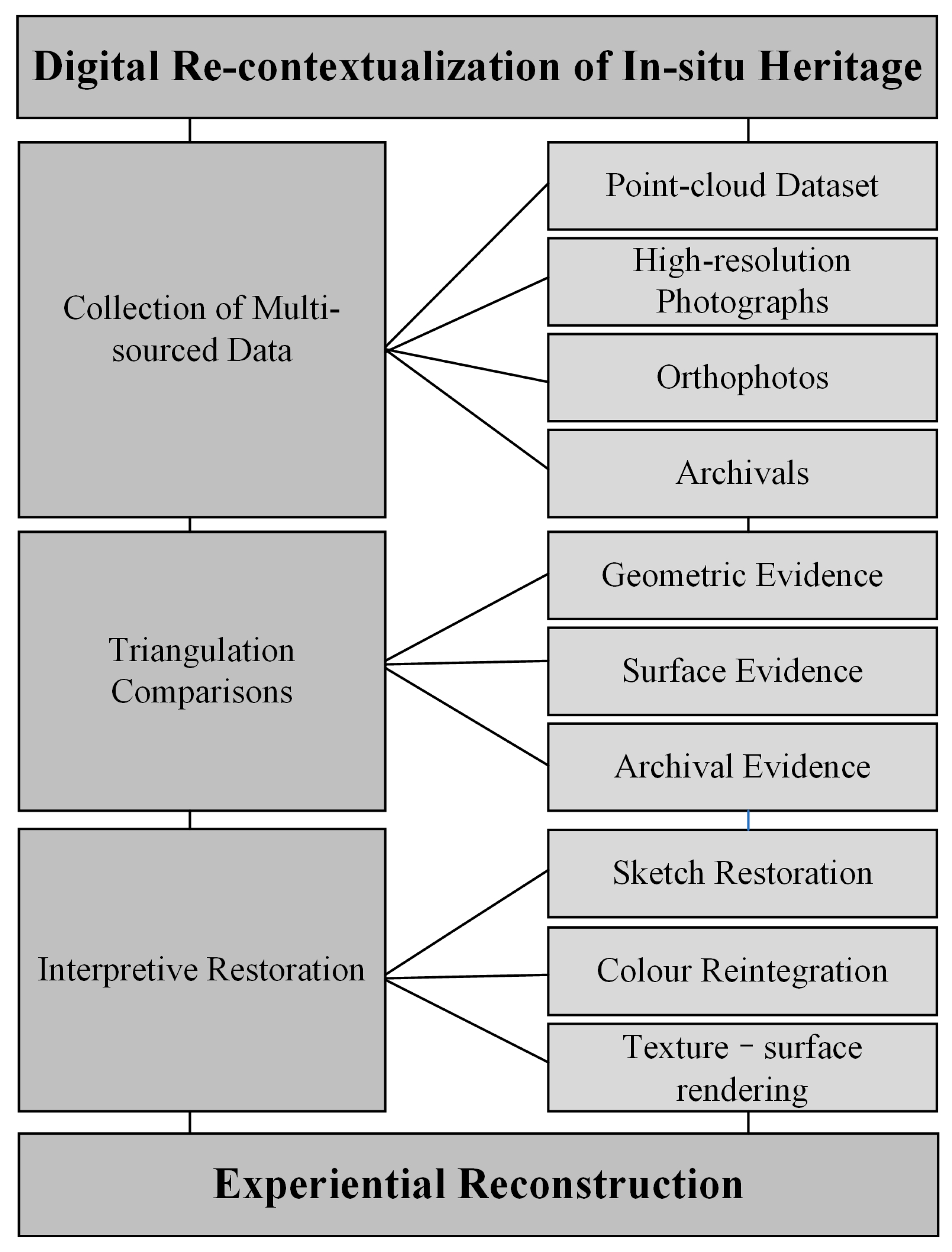
This framework is one of digital re-contextualization, integrating the multi-sourced data and interpretative restoration of imagery to reconstruct the experience of the period in a virtual way. Multi-sourced data included a point cloud dataset, high-resolution photographs, orthophotos, and archival materials. These data can be classified into geometric evidence, surface evidence, and archival evidence, and subsequently integrated through the triangulation comparisons. Interpretive restoration process involves three phases: sketch restoration, color reintegration, and texture–surface rendering (Figure 1).
Unlike digital documentation and restoration, digital re-contextualization does more than use digital methods to recreate the previous appearance of heritage. It also explores why this appearance was formed, what function the heritage once served, and what role it played in historical development. In this way, the restored heritage is no longer treated as a single object, but as a whole with rich stories and meanings. The advantages of digital re-contextualization are shown in the following aspects: (1) Restoration of dynamic context. Traditional documentation focuses on capturing heritage data with high precision at a specific moment in time [30]. It is a static record. In contrast, digital re-contextualization uses digital methods to place heritage in its original historical, social, cultural, and religious context, and to show how it altered across different periods. (2) Integration of multi-source heterogeneous data to build a narrative framework. Traditional documentation usually focuses on a single type of data, such as 3D point clouds or high-resolution images [31]. Digital re-contextualization emphasizes the integration of multi-modal data. These data are no longer separate pieces of information. Instead, they are organized within a framework and combined into a whole that presents a narrative while being interpretive and analytical. (3) Emphasis on research-driven restoration and interpretation, rather than visual reconstruction alone. Traditional digital restoration often focuses more on making something look “good” or “realistic”, and may sometimes ignore the rigor of the research behind it [32]. The digital re-contextualization framework is research-driven. Digital restoration is not only a technical task but also a process based on careful research in archaeology, art history, and material studies, together with evidence from historical archives for inference and verification. Its purpose is to use digital methods to provide scholarly interpretation and visual evidence for the context of the heritage itself. (4) Promoting multi-dimensional understanding and participation through interactive experience. Digital re-contextualization offers deeper analytical tools and richer interactive experiences. It connects the heritage with related historical events, figures, artistic styles, and other information. It allows users to switch between different historical periods and observe the heritage’s alterations. It also supports different types of users, helping them understand, study, and compare information through data at multiple levels and in multiple dimensions.

3. Methodology

3.1. Study Area

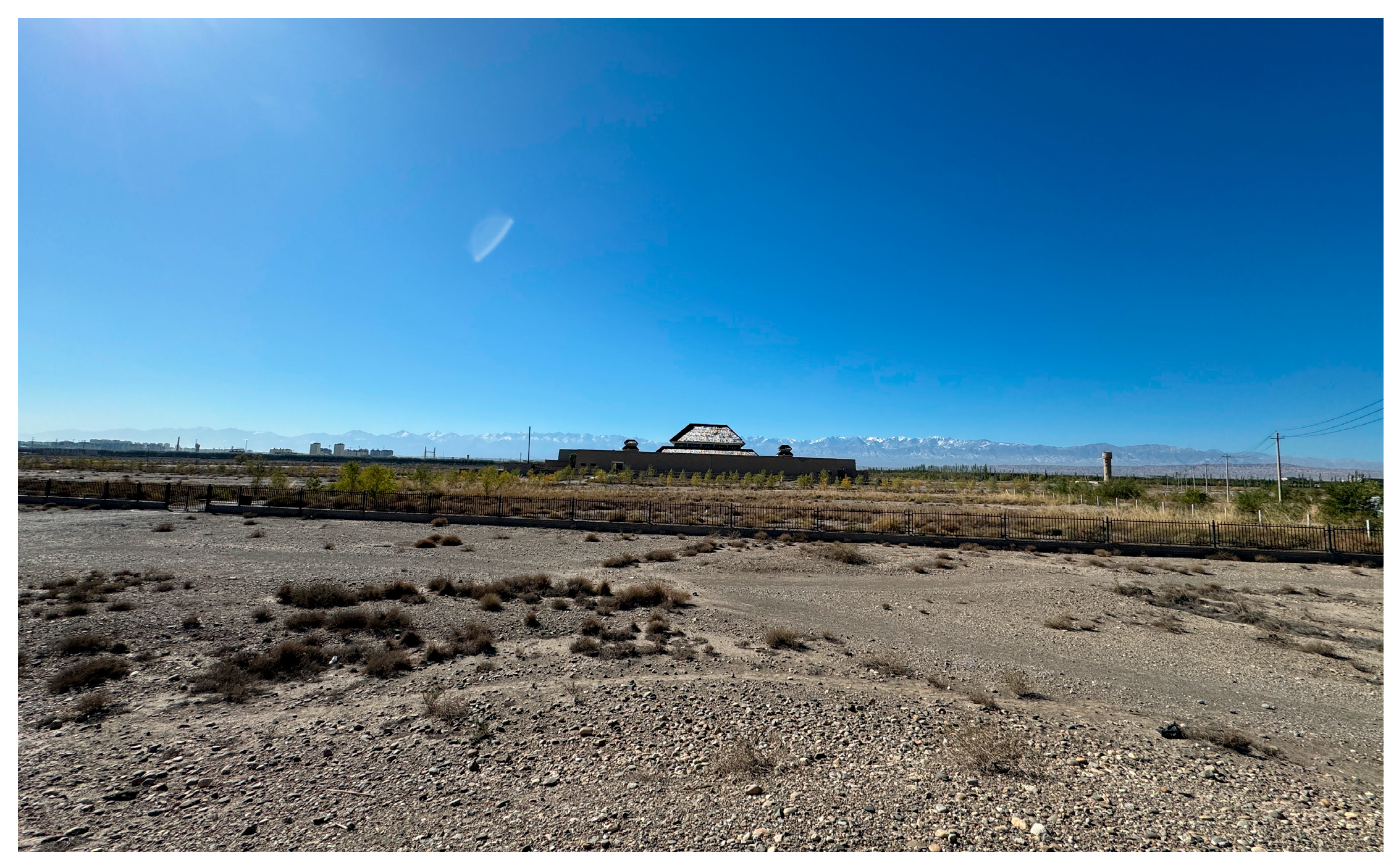
This study selects the Dingjiazha M5 Muraled Tomb, Jiuquan, as a case study for digital conservation and reconstruction. The tomb lies on the Gobi flats of Suzhou District. It is in the northwest of Jiuquan in Gansu, 8 km away from Suzhou (Figure 2), and was built during the Eastern Jin period (ca. 4th–5th century AD). Its occupant was assumed to be a person of the highest rank during the Wu-liang Period in the Hexi Region (AD 314–439), according to its form and scales. The M5 Muraled Tomb was a typical case during the Western Liang to Northern Liang Periods of the Sixteen Kingdoms, as it combined exceptional archaeological significance with outstanding artistic appeal, and offered an irreplaceable opportunity for understanding ancient social structure and cultural change.
From a historical perspective, its murals vividly reproduced the social life in the Hexi Corridor from the 4th to 5th centuries through banquets, farming, herding, and other scenes. It reflected the integration between Han culture and the Qiang, Xianbei, Xiongnu, and other peoples. Particularly for the “celestial phenomenon (Tianxiang)” on the tomb ceiling, including the Four Spirits, Garuda, and Auspicious Clouds, it identified the fusion of the astronomical concepts in the Central Plain and the western regions, and the cultural interaction along the Silk Road.
From a physical perspective, it had a complex spatial structure with two chambers and one corridor. In every space, burial goods were scattered on the earth in a certain way, such as pottery jars and bronze ornaments. These goods and paintings on the walls with its spatial structures illuminated the daily lives of elite families, and local culture and beliefs in the Hexi Corridor.
However, after a comparison of photographs in the 1970s, it was found that the murals of the M5 Tomb had already suffered severe damage owing to the drastic changes in the local environment. To make matters worse, such deterioration would be likely to accelerate in the future. Located on the Gobi flats, the tomb was closed and formed a stable microclimate. After the excavation, the external setting and internal environment of the tomb were disrupted. The annual temperature difference in this region can be as high as 70 °C. However, the chamber of this tomb is accessed through a narrow passage that extends 12 m deep at an approximately 18 degree angle [33]. The passage connects the chamber and a protective shelter on the surface, and a constructed system insulates the chamber from the direct impact of the external environment, and prevents the extreme temperatures outside from penetrating the interior. The excavation, however, disrupted this protective system. Frequent sandstorms and fluctuating humidity have caused the earthen plaster to crumble and the pigment layer to flake and blister. The seepage through structural fissures continuously worsened its salting crystallization. Fortunately, its entire structure and some murals have been well preserved, inspiring much research and many archival materials, which can provide a solid foundation for its digital re-contextualization.

3.2. Data Acquisition and Triangulation Comparisons

3.2.1. Geometric Evidence

In this study, we acquired geometric evidence through laser scanning points. First, we built a control system based on the World Coordinate System CGCS 2000. This system implemented the primary control with BeiDou RTK, and a first-order traverse survey with the Leica TS15i total station. It achieved a highly accurate control system, comprising the horizontal-angle standard error ≤ ±1″ and a side-length relative error ≤ 1/30,000.
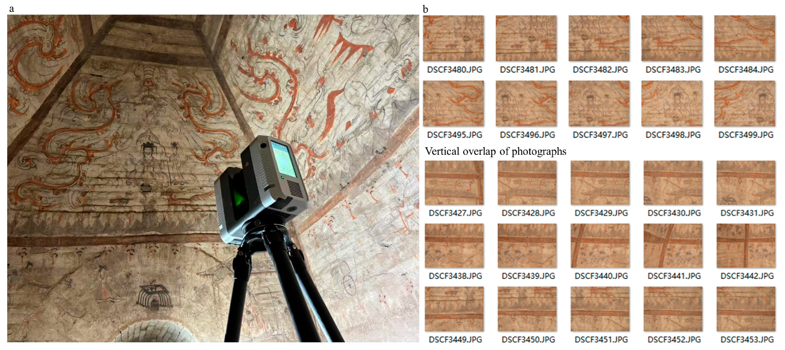
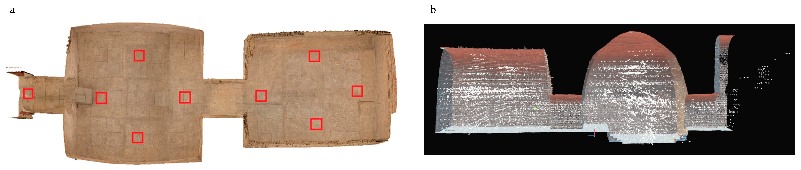
Then, data collection was implemented using a Leica RTC360 scanner (accuracy from 1 mm + 10 ppm) to scan the internal chamber, with 360° and high-precision positioning. The RTC360 was selected for its millimeter-level precision and rapid data acquisition capability, which are essential for capturing intricate surface details and structural defects in heritage documentation (Figure 3a). The scanning set 9 strategically distributed positions in the chamber, to ensure complete coverage of the irregular chamber geometry while minimizing occlusion effects from wall protrusions and the vaulted ceiling, and took 4757 photographs. Figure 3b and Figure 4 display the positions in the chamber, and parts of the photographs. The latter were captured with 80% horizontal and 70% vertical overlap to guarantee sufficient image redundancy for robust photogrammetric processing, ensuring seamless point cloud registration and eliminating data gaps in the final 3D model. Then, Leica Cyclone was utilized to merge the point cloud data from all stations, to ensure the registration error was below 2 mm. This step captured the structure of the walls as well as minor defects such as pits and cracks.

3.2.2. Surface Evidence

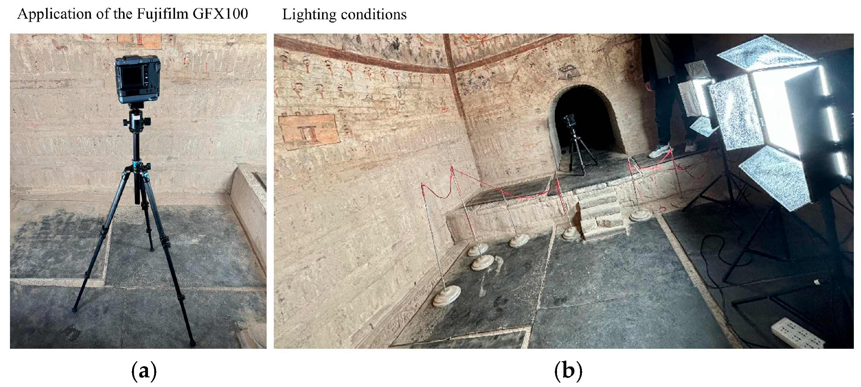
Surface evidence can be obtained through high-accuracy photographs and photogrammetry. Photographs were taken with the Fujifilm GFX100, a medium-format 100-megapixel camera (pixel pitch 0.00376 mm), for its large sensor size (43.8 × 32.9 mm) and high pixel count, which provided exceptional dynamic range and low-light performance critical for capturing subtle color variations and fine details in the dimly lit tomb environment where insufficient light or shade occurred in some areas of the chamber. The camera has superior optics that can deliver a texture resolution of 300 dpi, reveal the finest mural details, and guarantee the data’s fidelity (Figure 5).
To ensure high-quality photographs, full-spectrum continuous LED lights were used to eliminate the flickering and color inconsistency associated with traditional lighting, ensuring stable illumination for long-exposure photography in low-light conditions. Ruiying LP-2805TDX lights with a color temperature of 5600 K were chosen to approximate natural daylight, minimizing color cast and facilitating the accurate color reproduction of the original pigments. Larger areas were illuminated with direct 45-degree lighting to provide uniform, shadow-minimized coverage across expansive wall surfaces, while narrower sections utilized 45-degree reflected light to soften harsh shadows and prevent overexposure in confined spaces with limited clearance. A SEKONIC L-758D light meter and a C-500 color meter were used on-site to quantitatively verify illumination uniformity (maintaining luminance variation within ±5%) and confirm color temperature accuracy, thereby ensuring both visual consistency across the photographic dataset and faithful chromatic documentation of the murals.

3.2.3. Archival Evidence

Archival evidence was acquired from field investigations, historical documents, and old photographs. Field investigation was conducted in August 2025. The M5 Muraled Tomb and its surroundings were investigated to vitrify the contents in the archival evidence and compare the characteristics of these tombs in the same regions or in the same times. Key historical documents included old photographs and documents of this tomb [33,34].

3.2.4. Triangulation Comparisons

These collected data were compared with each other and analyzed, and the results were applied to the next step of the digital restoration. First, relevant archival materials were compared with the status of the tomb to determine the details of the destroyed parts. After these comparisons, several scholars were consulted, and relevant tombs built at the same time or in this area were compared. A completed reconstruction plan was proposed.
Then, the color fidelity of the collected orthophotographs was strictly controlled. The full-spectrum lighting, full-color balance target, and a standard color checker were employed before shooting. The color difference value (∆E) was maintained below 1.0, as verified using a 24-color chart. Pigment coordinates were also cross-checked against the analytical results published in “Pigment Analysis of the Muraled Tombs in Jiuquan and Jiayuguan of Gansu” [34] to ensure the accuracy of the information [33]. For faded or damaged areas, the restoration was meticulously compared against historical photographs and documents layer by layer in the case of the recreation.
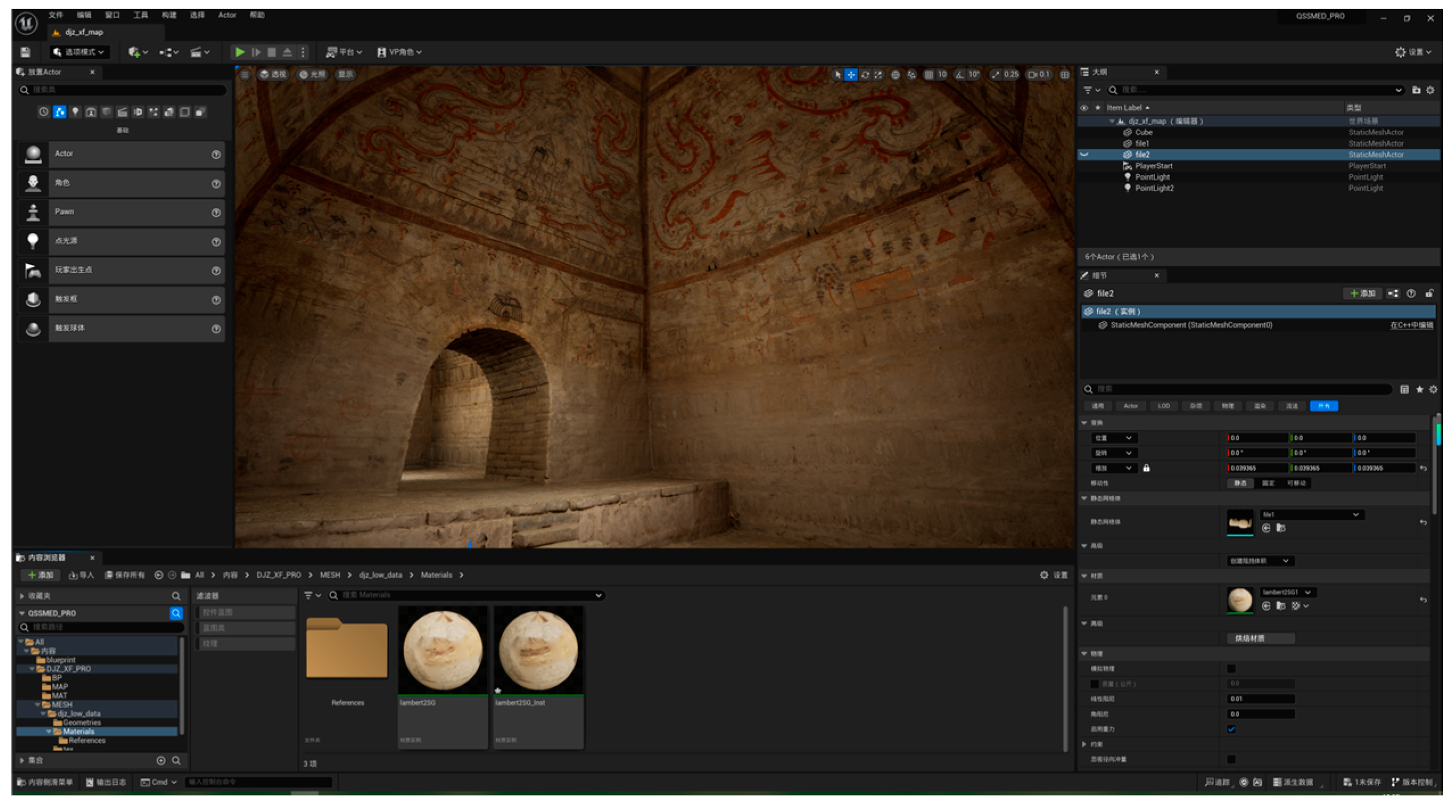
Third, the high-resolution imagery and orthophotographs were fused with the laser scanning data to build the 3D model. RealityCapture 1.5.1 was utilized to process the laser scanning data and the photographs separately at first. Then, they were integrated as a joint bundle adjustment with the help of the adaptive key-point detection and global optimization algorithms, and a high-precision 3D point cloud model was produced. The final model with accurate geometry and ultra-high-resolution color details was achieved through remeshing and retexturing within the World Coordinate System CGCS 2000 (Table 1). UE5 and Substance 3D Painter 9.0 were utilized to render the model and make it accessible via VR and on the Internet.
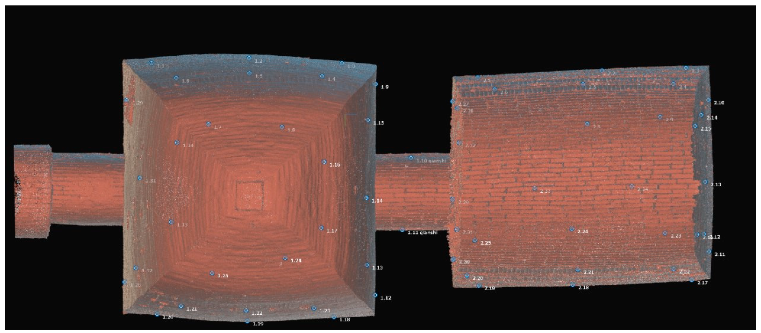
During the fusion, bundle adjustment was applied, and 68 control points were set in this model (Figure 6). It achieved a median reprojection error of 0.01 pixels, a maximum of 0.08 pixels, and a mean of 0.01 pixels.

3.3. Interpretive Restoration

The interpretive restoration workflow consisted of sketch restoration, color reintegration, and texture–surface rendering. This process was not a simple software operation but a procedure of scholarly reasoning and visual argumentation based on multi-sourced evidence. Interpretive restoration acted as a bridge, connecting fragmented data with structured knowledge. It integrated these disparate pieces of information through triangulation comparison to form a unified, visual academic argument, thereby achieving a fundamental shift from mere “documentation” to meaningful “reconstruction”.

3.3.1. Sketch Restoration

Sketch restoration is a digital extension of the logic used in archaeological line drawing, representing an evidence-based judgment. The primary data include the current state of the murals captured from photographs and scans, while restoration evidence is mainly derived from historical photographs. A comparative analysis allows for the inference of missing content, features, and the trajectory of original linework.
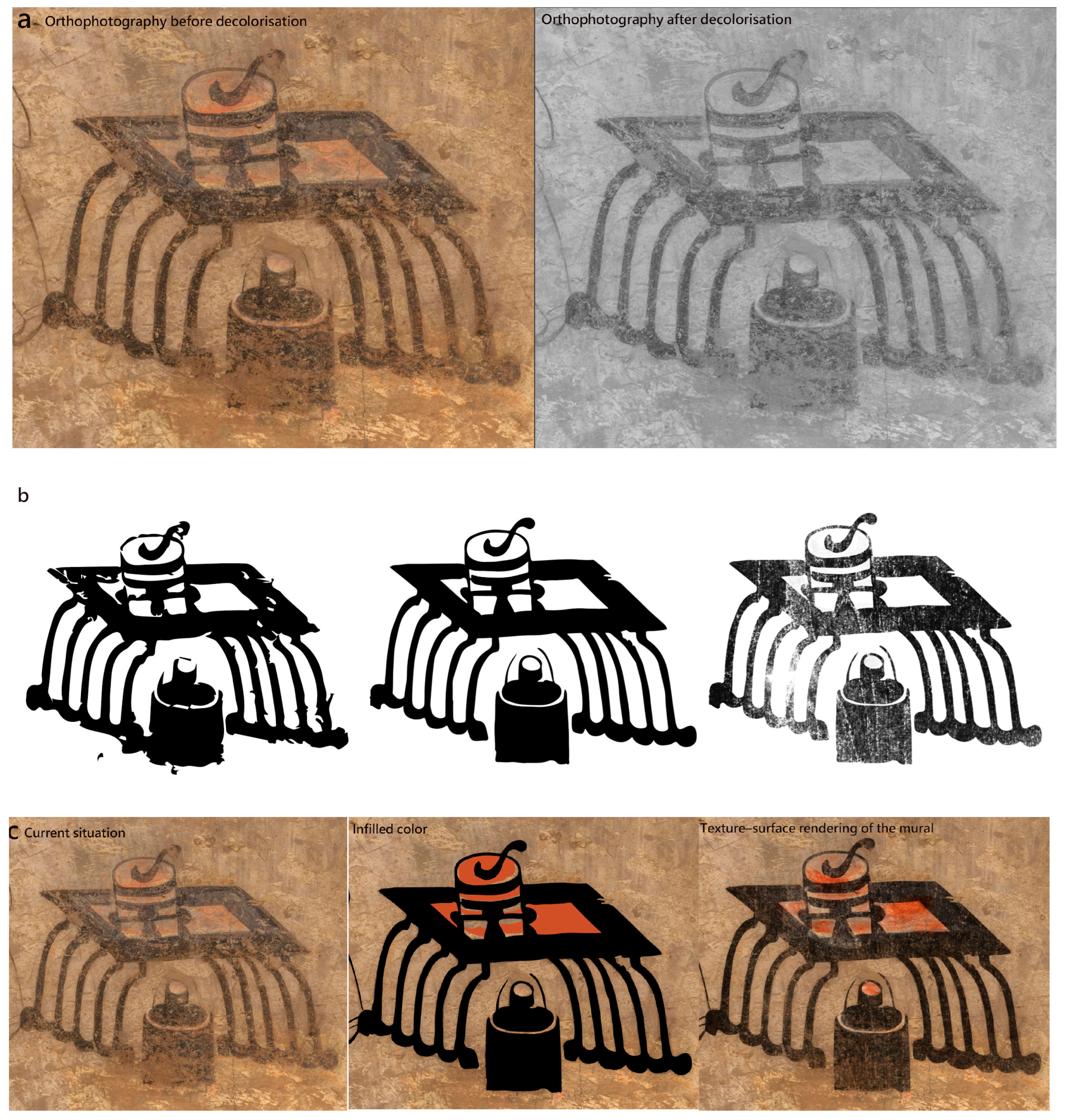
In this step, relevant orthophotos were imported into Photoshop 2020 and processed as a neutral grayscale image through the commands Image > Adjustments > Desaturate. Then, a high-contrast and crisp image could be acquired through the adjustment of Image > Adjustments > Levels.
Next, color-range sampling and vectorization were performed. The “Select > Color Range” tool was utilized to isolate the clearest black lines. The processed image was imported into Adobe Illustrator 2020 and converted into a vector work through “Object > Image Trace”. After manual refinement, the vector work was re-imported into Photoshop. After opening a new layer, brushes that mimic the original wall texture were utilized to reconstruct its previous brushwork. Finally, after slightly freehand adjustment combined with historical achievement, the restored sketch was finished.

3.3.2. Colour Reintegration

Color reintegration can be regarded as a kind of scientific color restoration based on pigment analysis and archival materials. The primary data sources were color-corrected orthophotos and scan data. The reference data were extant murals and historical photographs. Through comparison, the original colors of the murals were restored.
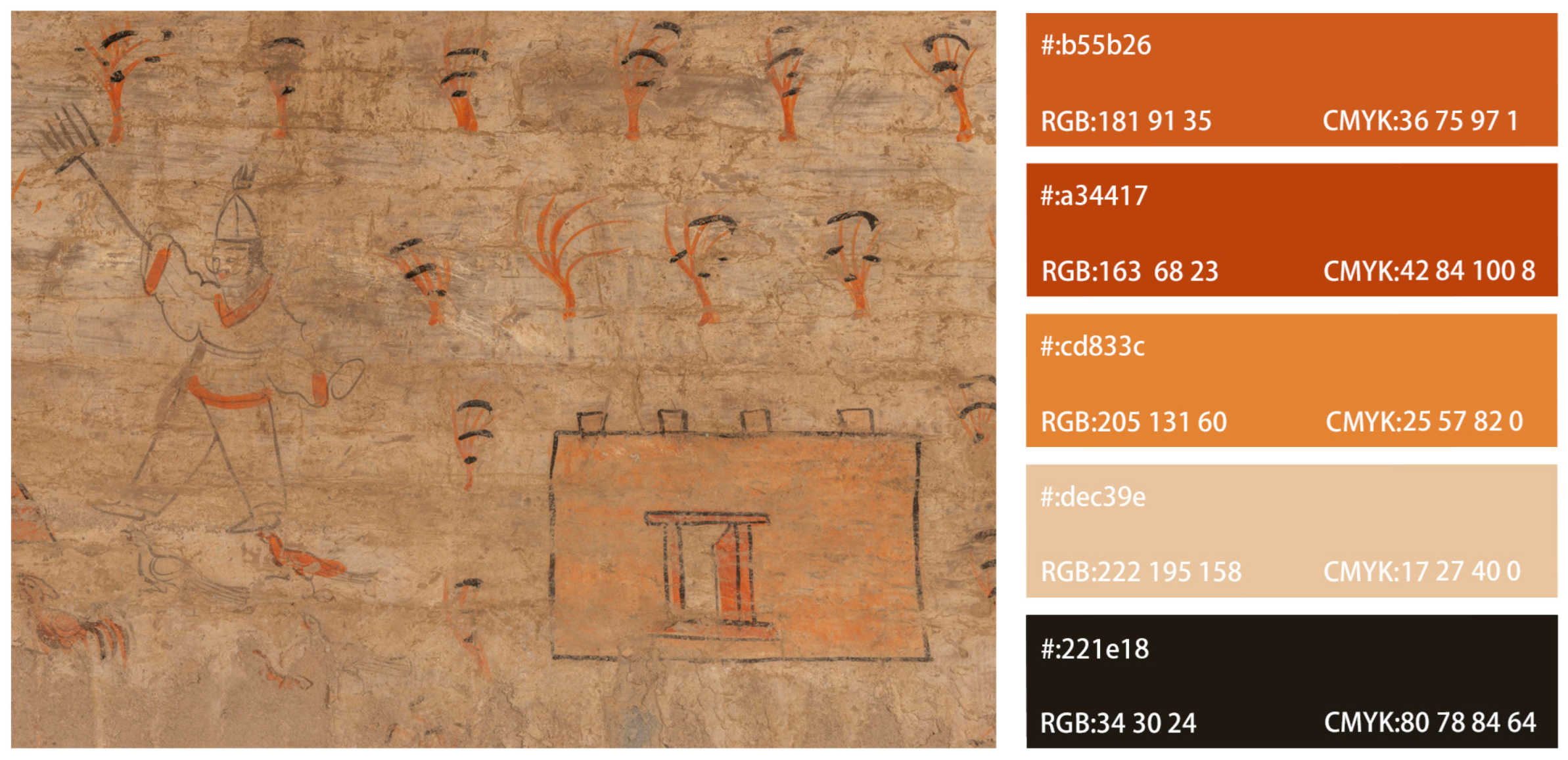
In this step, a reference color palette was established and colors were extracted. Using the Eyedropper tool, colors were sampled from unfaded areas to create a baseline color chart. Based on research of the literature, the mural pigments, including carbon black, chalk, azurite, iron-rich red clay, and iron brown, were analyzed. The remaining colors were scientifically reconstructed (Figure 7).
Then, regional segmentation and color block completion were carried out. Each wall was set against a white background. The contours, shapes, and colors of the murals were defined from historical documents and records, such as red, black and other subsidiary colors. Relevant software was utilized to fill in the blank or gradient areas, and ensure the coordination between the restored parts and the previous parts.

3.3.3. Texture–Surface Rendering

Texture–surface rendering can be regarded as a digital simulation of ancient painting techniques and materials. It relied on high-resolution scan data, cross-referenced with historical and on-site photographs. The restoration rationale was grounded in a comprehensive comparative analysis that referenced historical photographs of this tomb, archaeological line drawings, and textural evidence from contemporaneous murals in this region of the same period, ensuring inferential reconstruction was anchored in empirical and contextual evidence rather than conjecture. This comparative process simulated the original application of pigments and restored the appropriate environmental texture and materiality to the digital model.
The first step is the texture simulation of the ground layer and the pigment layer. For the areas where the paint has completely flaked off, the simulation inferred the original surface characteristics through pattern analysis of extant adjacent areas and comparative study of analogous motifs from well-preserved sections within the same tomb and period-correlative burial sites, adjusting surface relief and grain to match documented historical conditions.
The next step is the integration of the texture filters and freehand paintings. Content-Aware Fill in Adobe Photoshop was employed for digital inpainting, enabling precise, non-destructive restoration of lacunae. These interventions were executed in strict adherence to the principle of reversibility and archaeological distinguishability. This practice followed the “recognizability” principle of archaeological conservation, and repaired sections exhibited subtle chromatic and textural differentiation from original areas, thereby preventing the falsification of historical information while facilitating scholarly identification of intervention boundaries (Figure 8).

3.4. Validation

This study utilized visual comparisons, data comparisons, and expert evaluation to validate the reconstructed consequence, and ensure the digital reconstruction’s traceability and scholarly rigor.

3.4.1. Visual Comparisons

For the data parts, the continuity of lines and blocks, and the recovery of details were compared according to the comparison of the original orthophotos, desaturated images, and restoration vectors. For its integral composition, the integral compositions of the tombs before and after the restoration were compared in the software, particularly for their overall styles, initial line paths, and colors.
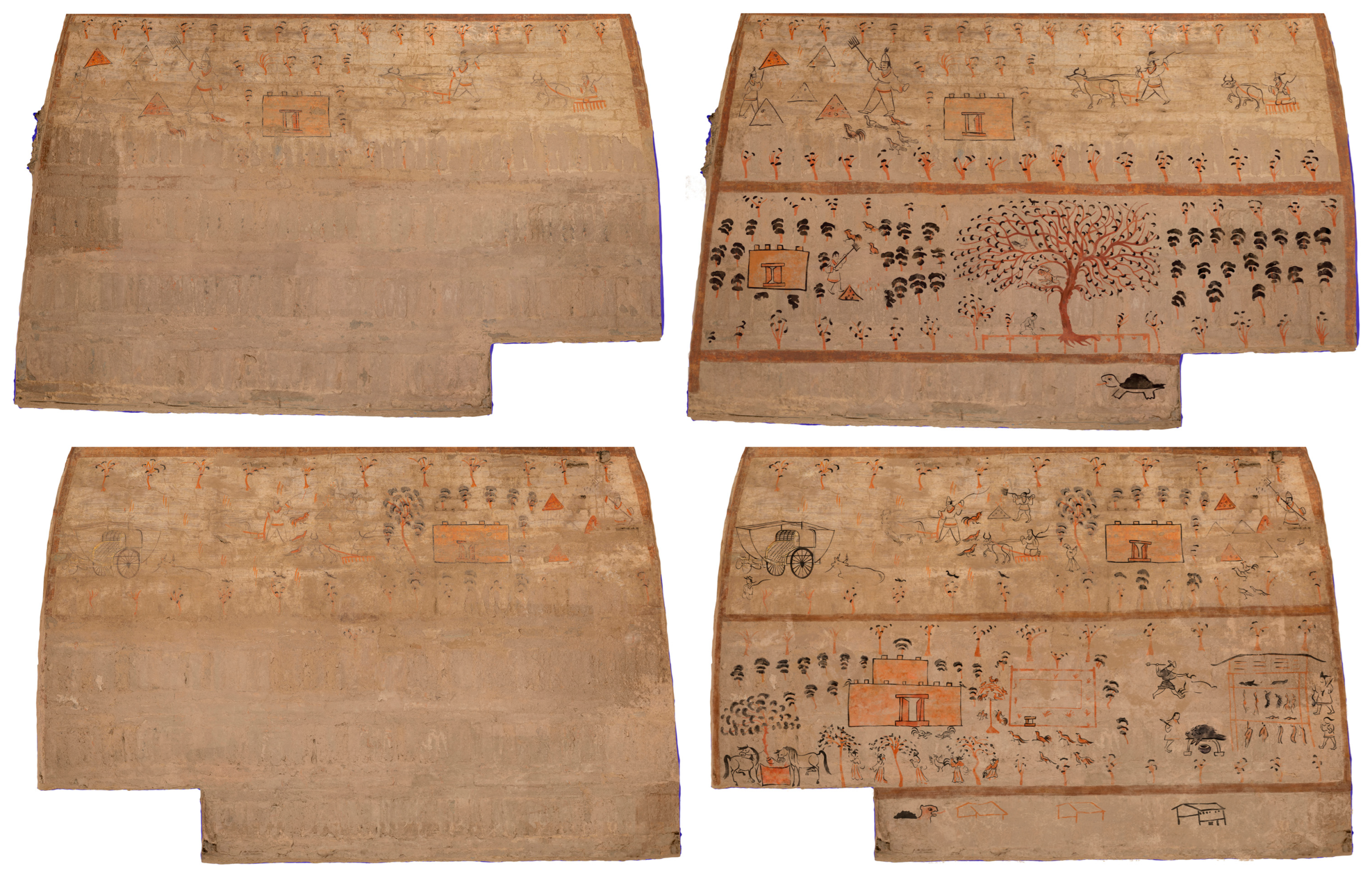
For the comparison of its historical imagery, relevant historical photographs and current images were compared with the reconstructed 3D models. Details such as the tree, the mythical beast, and the nude female figure were tested to confirm that the digital outcome preserved the original artistic characters and faithfully replicated local details.

3.4.2. Data Comparisons

To validate the accuracy of the reconstructed 3D model, 30% of the ground control points (GCPs) were reserved as check points and were excluded from the modeling process. A comparison between the exported coordinates of these check points and their actual measured values yielded the following results (Table 2):
As data of these ground control points demonstrated, the mean of the total deviation is 0.045781, with a minimum of 0, a maximum of 0.43, and a standard deviation of 0.057874. The mean of triangulation uncertainty is 0.015031, with a minimum of 0.0072, a maximum of 0.0336, and a standard deviation of 0.005392 (Table 3).
Regarding the reconciliation of inconsistencies between heterogeneous data, this study resolved the conflicts through the division of layers of these data. Because the laser scanning data can capture three-dimensional geometric morphology through emitted laser beams with high sensitivity to minute depressions and structural deformations, they were prioritized for topographic and morphological determinations. Conversely, high-resolution photography, which records two-dimensional chromatic and textural information, lacks direct three-dimensional acquisition capability, and was prioritized for surface color and pigment characterization. When geometric discontinuities detected with laser scanning appeared incongruous with visually continuous color fields in photographic data, a multi-criteria evaluation was implemented. The discrepancy was first subjected to cross-validation against historical imagery and on-site condition records to determine whether the geometric anomaly represented original construction, subsequent deterioration, or restoration intervention. If historical documentation confirmed the feature as original or diagnostically significant, the geometric data were retained and the texture mapping was adjusted to reflect subsurface conditions through semi-transparent overlay techniques. If the anomaly was identified as post-original damage with no historical value, the photographic texture data were prioritized to restore visual continuity, with the geometric depression preserved as metadata-layer annotation rather than surface manifestation. This conflict resolution framework was operationalized through computer vision and artificial intelligence algorithms, specifically utilizing iterative closest point (ICP) registration and mesh-texture projection optimization, to achieve weighted fusion of three-dimensional point clouds and two-dimensional imagery. The algorithmic weighting assigned 70% priority to laser scanning for geometric fidelity and 30% to photogrammetric data for chromatic accuracy in zones of confirmed structural integrity, with dynamic adjustment based on local confidence metrics derived from point density and image sharpness analysis. This methodological approach ensures that the final digital restoration maintains both geometric precision and visual authenticity while preserving full traceability of interpretive decisions regarding data source prioritization.

3.4.3. Expert Evaluation

Expert evaluation was conducted throughout the project by a five-person panel, which included archaeologists, history professors, and exhibition specialists. The process was divided into the following three phases:
(1)
Initial assessment and standard setting: This phase aimed to resolve interpretive issues arising from incomplete or ambiguous source materials. Through group discussions, the expert panel analyzed key elements such as the tomb’s structure, mural content, colors, and textures to establish restoration standards. The core principle was to ensure all details aligned with known archaeological and historical evidence, laying an accurate foundation for subsequent work.
(2)
Mid-term supervision and stylistic control: During the restoration process, the expert panel remained involved to assess whether the restored elements were stylistically consistent with the original artwork. They also discussed the exhibition plan to ensure the final presentation would respect historical authenticity while being accessible to a modern audience.
(3)
Final outcome validation: After the restoration was completed, the panel acted as an independent body to evaluate the final results. The validation criteria included the authenticity of the restoration, the accuracy of its conveyance of the historical context, and whether the exhibition method could successfully stimulate public engagement and reflection. This phase served as the project’s core external validation, ensuring the final quality of the restoration work.

4. Results

4.1. Visualisation of the Lost Iconography

This research utilized digital technology to acquire multi-sourced data. Through a process of triangulation comparison and interpretive restoration, it has successfully restored critical visual details that have been lost for decades due to deterioration.
As shown in Figure 9, the murals in the antechamber of the M5 Muraled Tomb suffered the most severe damage. However, the restoration has presented their original contents. Relevant archival work documented the imagery in this chamber before it was damaged, but severe salt efflorescence and pigment loss had destroyed details, such as the giant tree, the mythical beast, and the nude female figure. This loss significantly hindered the study of art history. However, through our digital restoration, these images are now legible and visible once more.
This process was based on careful comparisons. Its original line work was restored through a scholarly process of vector tracing. The restoration integrated the current high-resolution orthophotos with archival photographs. Thus, this restoration had high verifiability and provided new evidence for further academic discussion. The restoration has become a non-invasive approach to retrieve lost visual data physically and reintroduce them into the field of iconographical interpretation.

4.2. Re-Contextualization of Dingjiazha M5 Muraled Tomb

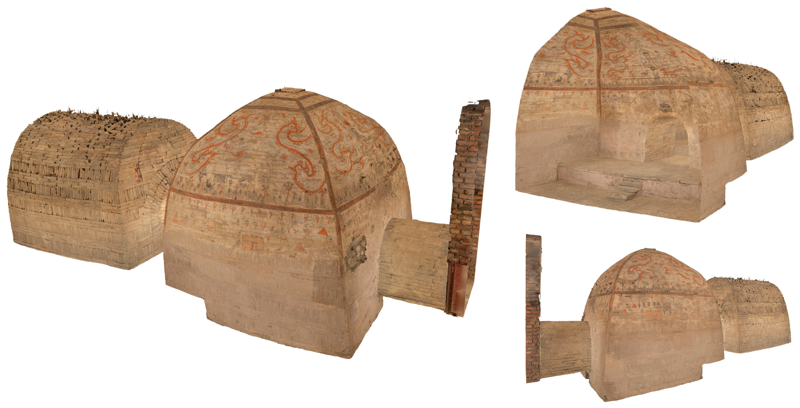
Except for the restoration of the murals, this study reconstructed a 3D model of the tomb. This reconstruction transcended the limitations of traditional 2D analysis, revealing the tomb’s stories or spirits in a more visual and intuitive way. The model demonstrated that the tomb was not merely like a gallery displaying the isolated images but a carefully organized integral landscape to guide the soul of the deceased and manifest their status (Figure 10). Figure 11 uses an axonometric view to display the restored tomb structure. Although this perspective does not correspond to a real-world physical experience, it allows the tomb murals to be presented completely on a single plane. It would be easier for researchers to conduct a macro-level analysis of the murals’ overall layout, composition, and the distribution of damage.
In previous research, murals in the antechamber—such as the scene of Yanyin on the front wall, and the scenes of agriculture, livestock, and rituals on the two side walls—were presented as separate images. Scholars needed to speculate their connections. However, this model made the narrative clues of these stories displayed on the murals visual and comprehensible. The model showed the relationship between these murals. The mural on the front wall was regarded as the visual core, supported by the scenes on the side walls. These contents reflected from the murals explained the tomb owner’s wealth and power, and why they were able to hold such a grand banquet.
Furthermore, this study identified an experiential route through the model: a progression from secular life and social status in the antechamber to the more spiritual and celestial themes in the rear chamber. This route connected two chambers and a corridor, embodying a transition from the secular to the sacred. Based on this finding, this study utilized VR and AR to build an online experiential system. This system allowed the public to virtually roam this tomb and compare the murals before and after restoration (Figure 11).
This VR restoration was developed using the Unreal Engine 5 platform. It is modeled at a 1:1 physical scale, strictly adhering to the real tomb’s structure, and supports an immersive free-roaming experience. The interaction design incorporates VR head tracking and controllers, utilizing UE5’s native SteamVR framework for standardized VR compatibility. Users can navigate precisely within the digital tomb by either walking freely or using controller-based teleportation. A parallel PC version was also developed, which allows for real-time comparison and switching between textures before and after restoration, making it easier for team members to collaborate on reviews and proposal evaluations.
The 3D model transforms our understanding of the tomb from a collection of paintings to a narrative carrier. It compels us to consider how the visibility, experiential routes, physical movements, spatial structure, and objects can be essential for the construction of the context of life, death, and belief, which could never be understood from images alone.

5. Discussion

5.1. Contribution to the Heritage Conservation Studies

The major contribution of this study is proposing a framework of digital re-contextualization for heritage conservation. This framework is significantly different from traditional physical conservation and digital restorations, for such conservation prioritized the preservation of mural fragments, neglecting their original spatial composition and context. Previous digital restoration simply documented geometric form or visual appearance. However, this framework seeks to reconnect heritage properties with their historical cultural functions and contextual meanings across different periods. By integrating historical archives with high-precision texture restoration techniques, the framework re-establishes the relationship between a heritage object’s visual information and the specific ritual, social, and spatial contexts in which it once existed.
Traditional visualization methods only emphasize the display of geometric models, while this proposed framework constructs an immersive virtual scene and embeds interactive information within it, enabling users not merely to “view” heritage remotely but to experience the atmosphere and cultural logic of a particular historical setting as well. In this way, the proposed framework moves beyond simple visual navigation and supports a deeper understanding and cognition of heritage as a multi-layered cultural and spatial entity, offering a more meaningful method for the digital conservation of heritage.

5.2. Technology as a Hermeneutic Tool

The primary aim of this research is to build a re-contextualization framework that repositions digital technology from a documentation method to a hermeneutic tool. Traditionally, photography and scanning were seen as passive documentation methods. This framework, however, employs innovative technologies as an engine for interpretation and validation, and creates an iterative process where data, reconstruction, and analysis iteratively inform one another.
This process is more than a simple integration of digital techniques. Every step of this process is an evidence-based interpretation. For instance, sketch reconstruction with Adobe Illustrator is an interpretation guided by the comparative analysis of surviving motifs. The digital model can be regarded as a testable hypothesis. The reconstruction of a 3D model was based on early photographs, stylistic analysis, and its status. It was through this process that the experiential route from the secular to the sacred was identified.
Furthermore, using UE5 for PBR-based material mapping and real-time rendering allows us to simulate the original appearance of the murals under various lighting conditions, and improves the understanding of the aesthetic choices and intended emotional impact of the space [2,3]. This 3D model can offer a highly immersive experience, and the platform can be used to display the implementation of this restoration. It can enhance the accessibility for the public, and allow more users to critically engage with the digital restoration process, directly addressing ethical concerns in heritage visualization.
In this study, technology became a tool for exploring the living past, enabling researchers to dynamically construct, critique, and refine their understanding of the tomb’s significance and functions. The digital model is therefore not an end product, but a new and robust starting point for deeper scholarly inquiry.

5.3. Implications for Heritage Digitalisation

The framework of digital re-contextualization is not limited to muraled tombs but has significant value for other forms of in situ heritage, such as rock art, Buddhist grottoes, and relics. These types of heritage often face severe degradation or fragmentation, leading to a loss of their contexts. The framework aims to integrate multi-sourced data into a unified, analyzable digital surrogate. This can allow the heritage to be explored and conserved without secondary damage, and enable the documentation, research, and virtual preservation of fragile sites within a single system.
Furthermore, the framework connects academic research and public engagement. The high-fidelity digital assets generated are not confined to academic purposes; they can be altered into immersive and accessible experiences. For example, with VR or AR, the public can virtually experience the reconstructed tomb, and appreciate its space and details of the murals. This form of conservation moves beyond fragmentary and static displays, allowing the public to experience the cultural context holistically and dynamically. It also in turn fosters public interest in history and heritage, and contributes to the transmission and revitalization of traditional culture.

5.4. Limitations and Future Directions

Although the framework has significant advancements, it has limitations. First, the restoration process contains an unavoidable element of subjectivity. Although this study stressed that restoration was strictly based on early photographs, documents, and physical evidence, there were some destroyed areas with incomplete or ambiguous data. In such cases, the restoration of missing lines or patterns relied on the professional judgment of researchers and digital artists. Additionally, the high cost of laser scanning equipment and the requirement of specialized skills for software such as UE5 impeded the development of this framework to some extent.
In the future, the application of artificial intelligence offers a promising way for further refining the proposed framework. Machine learning models could be trained on a large corpus of murals from the Wei and Jin Dynasties to support the generation of restoration suggestions that are stylistically consistent with the original works, thereby reducing subjectivity to a certain extent.
Second, the development of an open data platform would be a valuable extension of this study. By making raw data, intermediate results, and final models accessible to the public and to other researchers, the platform could facilitate verification, critique, and reuse of the restoration process. This would contribute to a more transparent, cumulative, and collaborative research environment, while also improving the reproducibility of digital heritage workflows.
Finally, the current model could be enhanced by integrating multi-sensory elements, such as soundscapes, to achieve a more comprehensive sensory re-contextualization, further enriching interpretation and public engagement.

6. Conclusions

This study proposed the framework of digital re-contextualization, which is more than a technical restoration of the Dingjiazha M5 Muraled Tomb. It could be regarded as a significant methodological exploration. By systematically integrating multi-sourced data, triangulation comparisons, interpretive restorations, and experiential reconstruction, it effectively transformed the fragmented information in the in situ heritage into analyzable, experiential, and structured knowledge, and digitally reconstructed its lost spatial context and ritual experience.
This study explores how to approach the virtual reconstruction of cultural heritage responsibly and critically in the digital age. It develops a framework that is both technically feasible and theoretically robust. On the one hand, it ensures the outcome is a verifiable restitution rather than a subjective recreation. On the other hand, it improves the digital technology from a documentation technique to a hermeneutic tool, transforming the digital reconstruction into a dynamic process of scholarly experimentation. This study marks a profound alteration in digital humanities from “seeing the past” to truly “understanding the past”, establishing a promising and meaningful new approach to conserving, interpreting, and bequeathing in situ heritage.

Author Contributions

Conceptualization, Yueying Chen; methodology, Yueying Chen; software, Jie Xiao and Siqi Zheng; validation, Yueying Chen and Wenbin Wei; formal analysis, Jie Xiao and Siqi Zheng; investigation, Yueying Chen, Wenbin Wei, Jie Xiao and Siqi Zheng; resources, Wenbin Wei; data curation, Jie Xiao and Siqi Zheng; writing—original draft preparation, Yueying Chen; writing—review and editing, Yueying Chen and Wenbin Wei; visualization, Yueying Chen; supervision, Wenbin Wei; project administration, Yueying Chen and Wenbin Wei; funding acquisition, Yueying Chen and Wenbin Wei All authors have read and agreed to the published version of the manuscript.

Funding

This research was funded by the Fujian Provincial Social Science Fund, grant number FJ2025C212; Fundamental Research Funds for the Central Universities, grant number 20720251004; and Archeological Excavation of Weiling Street (Stage 1), grant number 413000/071200142. The APC was funded by the Archaeological Excavation of Weiling Street (Stage 1).

Data Availability Statement

The original contributions presented in the study are included in the article, further inquiries can be directed to the corresponding author.

Conflicts of Interest

Authors Jie Xiao and Siqi Zheng were employed by the Wuhan Yiteng Technology Co., Ltd. The remaining authors declare that the research was conducted in the absence of any commercial or financial relationships that could be construed as a potential conflict of interest.

References

  1. Makellaraki, A.; Di Pietra, V.; Dabove, P.; Bagheri, M. Ultra-Wideband System for Museum Visitors Tracking: Towards the Integration of the Positioning System with the Vision Sensors. ISPRS Int. J. Geo-Inf. 2026, 15, 33. [Google Scholar] [CrossRef]
  2. Dolińska, N.; Wojciechowska, G.; Bac-Bronowicz, J.; Bednarz, Ł.J. GEPReS: A Geospatially Enabled Predictive Recommendation System for the Preventive Management of Historical Buildings. ISPRS Int. J. Geo-Inf. 2026, 15, 1. [Google Scholar] [CrossRef]
  3. Ferreira-Santos, J.; Pombo, L. The Art Nouveau Path: Trajectory Analysis and Spatial Storytelling Through a Location-Based Augmented Reality Game in Urban Heritage. ISPRS Int. J. Geo-Inf. 2025, 14, 469. [Google Scholar] [CrossRef]
  4. Roggio, D.S.; Shokrollahi, S.; Forte, A.; Bitelli, G. Exploring Historical Changes to Architectural Heritage Through Reality-Based 3D Modeling and Virtual Reality: A Case Study. ISPRS Int. J. Geo-Inf. 2025, 14, 353. [Google Scholar] [CrossRef]
  5. Chen, Y.; Wu, H.; Wei, W. Different Patterns of Religious Settlements Based on the Historic Landscape Approach: Cases of Buddhist Grottoes in Hexi Corridor. Religions 2024, 15, 1531. [Google Scholar] [CrossRef]
  6. Sigari, D. The figurative motifs in the portable art of Grotta Romanelli (southern Italy) within the late Pleistocene art tradition of southwestern Europe. J. Archaeol. Sci. Rep. 2026, 71, 105630. [Google Scholar] [CrossRef]
  7. Ilies, A.; Apopei, A.I.; Ilies, G.; Berdenov, Z.; Manea, V.C.; Ilies, D.C.; Caciora, T.; Barbu-Tudoran, L.; Hodor, N.; Alfehaid, M.M.; et al. Archaeometric study of a Romanian cave dwelling: Mineral composition and conservation aspects. NPJ Herit. Sci. 2026, 14, 75. [Google Scholar] [CrossRef]
  8. Ma, W.X.; Chen, Q.Q.; Wu, F.S.; He, D.P.; Duan, Y.L.; Yue, Y.Q.; Gu, J.D.; Yang, X.Y.; Feng, H.Y. Difference and environmental drivers of bacterial communities on wall paintings of the Maijishan and Mogao Grottoes, China. Front. Microbology 2025, 16, 1657118. [Google Scholar] [CrossRef]
  9. Li, C.; Wang, P.S.; Wang, X.R.; Gao, Y.; Zhang, W. Experimental Research on the Treatment of Saline-Alkali Diseases of Murals in Arzhai Grottoes With Salt-Tolerant Mineralizing Bacteria. Biotechnol. J. 2025, 20, e70044. [Google Scholar] [CrossRef]
  10. Tsairis, G.; Alexopoulou, A.G.; Zacharias, N.; Kakoulli, I. Close-Range Photogrammetry and RTI for 2.5D Documentation of Painted Surfaces: A Tiryns Mural Case Study. Coatings 2025, 15, 388. [Google Scholar] [CrossRef]
  11. Yan, H.H.; Zhang, X.R.; Zhang, Q.X.; Sun, F.; Dong, W.Q. Analysis and Research on the Pigments of Mural Painting Layer in the SanHuang Temple. Spectrosc. Spectr. Anal. 2024, 44, 1889–1895. [Google Scholar]
  12. Huang, R.; Feng, W.; Fan, M.Y.; Guo, Q.; Sun, J.Z. Learning multi-path CNN for mural deterioration detection. J. Ambient Intell. Humaniz. Comput. 2020, 11, 3101–3108. [Google Scholar] [CrossRef]
  13. Li, X.Y.; She, E.R.; Wen, J.Q.; Huang, Y.; Zha, J.R. Integrating In Situ Non-Destructive Techniques and Colourimetric Analysis to Evaluate Pigment Ageing and Environmental Effects on Tibetan Buddhist Murals. Chemosensors 2025, 13, 202. [Google Scholar] [CrossRef]
  14. Jin, C.; Guo, H.; Yu, H.K.; Li, B.; Yang, J.D.; Zhang, Y. Spectral Analysis of the Techniques and Materials Used to Make Murals. Spectrosc. Spectr. Anal. 2023, 43, 1147–1154. [Google Scholar]
  15. Xia, Y.; Xi, N.; Huang, J.H.; Wang, N.; Lei, Y.; Fu, Q.L.; Wang, W.F. Smalt: An under-recognized pigment commonly used in historical period China. J. Archaeol. Sci. 2019, 101, 89–98. [Google Scholar] [CrossRef]
  16. Parfenov, V.A. Use of 3D laser scanning for digital reconstruction and physical replication of sculptural monuments. In Optics for Arts, Architecture, and Archaeology VII; SPIE: Bellingham, WA, USA, 2019. [Google Scholar]
  17. Martinenko, A.; Pejic, M.; Obradovic, M.; Ristic, N.D. Advancing 3D reconstruction: Evaluating surveying techniques for medium-sized heritage objects. Measurement 2025, 256, 118596. [Google Scholar] [CrossRef]
  18. Jo, Y.H.; Hong, S. Three-Dimensional Digital Documentation of Cultural Heritage Site Based on the Convergence of Terrestrial Laser Scanning and Unmanned Aerial Vehicle Photogrammetry. ISPRS Int. J. Geo-Inf. 2019, 8, 53. [Google Scholar] [CrossRef]
  19. Puniach, E.; Cwiakala, P.; Wasilewski, M.; Majchrzak, L.; Guillen, P.; Escobar, C.; Marchewka-Dlugonska, J. Monitoring Archaeological Sites Affected by Natural and Anthropogenic Hazards Using Multitemporal UAV-Photogrammetry: A Case Study from the Barranca Valleys, Peru. J. Field Archaeol. 2026, 51, 159–178. [Google Scholar] [CrossRef]
  20. Hermon, S.; Moreau, R.; Lucchetti, L.; Orabi, R.; Soyluoglu, M.; Vassallo, V.; Levy, N.; Kakkoura, C.; Bakirtzis, N. Preparing the ground for the European Collaborative Cloud for Cultural Heritage (ECCCH) with heritage digital twins-multi-disciplinary data integration and visualisation for research and conservation: The case-study of a Nativity Icon from Deryneia, Cyprus. J. Cult. Herit. 2026, 79, 83–93. [Google Scholar] [CrossRef]
  21. Jia, Q.Z.; He, J.L. High-fidelity 3D reconstruction of cultural heritage via super-resolution and progressive Gaussian splatting. NPJ Herit. Sci. 2026, 14, 84. [Google Scholar] [CrossRef]
  22. Pham, H.G.; Kieu, Q.L. Balancing heritage preservation and tourism development: A case study of Non Nuoc Cao Bang UNESCO Global Geopark, Vietnam. Bull. Geogr. Socio-Exonomic Seris 2026, 71, 45–59. [Google Scholar] [CrossRef]
  23. Ren, X.J.; Hao, X.Y.; Xu, J.Y.; Xu, J.P. Digital rebirth: How task-technology fit drive immersion and user engagement in intangible cultural heritage VR. NPJ Herit. Sci. 2026, 14, 157. [Google Scholar] [CrossRef]
  24. Zhai, W.M.; Pan, C. Optimizing Virtual Annotations in 360° Mobile Museum Exhibitions: The Impact of Position and Border Design on User Experience and Visual Search Performance. Int. J. Huamn-Comput. Interact. 2026, 1–19. [Google Scholar] [CrossRef]
  25. Li, Z.L.; Fernández-Muñoz, C.; Alvarez-Marín, A.; Wang, Y.F. The Inheritance Path of Traditional Chinese Timber Structure Construction Techniques: Digital Practice of VR Mortise and Tenon. Sustainability 2026, 18, 2159. [Google Scholar] [CrossRef]
  26. Zhang, R.S.; Liu, H.J.; Kong, F. A neuro-architectural approach to emotional attachment evaluation with multimodal data: VR-empowered study of Beijing Langyuan Station’s industrial heritage renewal. Archit. Eng. Des. Manag. 2026, 1–28. [Google Scholar] [CrossRef]
  27. Tian, F.; Lu, Y.D.; Tu, M.Y.; Zhu, Q.L.; Li, Y.Z. Digital heritage integration of Kunqu opera and Suzhou classical gardens. NPJ Herit. Sci. 2026, 14, 78. [Google Scholar] [CrossRef]
  28. Ren, K.X.; Lam, J.F. Knowledge graph-driven digital preservation of intangible cultural heritage: A cross-cultural comparative study of Chinese and Western implementation paradigms. Humanit. Soc. Sci. Commun. 2026, 13, 147. [Google Scholar] [CrossRef]
  29. Li, Y.; Sahari, F. Fusion of robotics and deep learning for gamified rural landscape design: Toward intelligent interaction. Enternatiment Comput. 2026, 57, 101109. [Google Scholar] [CrossRef]
  30. Yastikli, N. Documentation of cultural heritage using digital photogrammetry and laser scanning. J. Cult. Herit. 2007, 8, 423–427. [Google Scholar] [CrossRef]
  31. Yan, D.F.; Yang, Y.M. Optimization of Control Point Layout for Orthophoto Generation of Indoor Murals. Sensors 2025, 25, 1588. [Google Scholar] [CrossRef]
  32. Yang, J.L.; Cao, J.; Yang, H.M.; Li, Y.H.; Wang, J.L. Digitally Assisted Preservation and Restoration of a Fragmented Mural in a Tang Tomb. Sens. Imaging 2021, 22, 32. [Google Scholar] [CrossRef]
  33. Xue, J.; Ma, Q.; Zhou, G. Pigment Analysis of the Muraled Tombs in Jiuquan and Jiayuguan of Gansu. Archaeology 1995, 277–281. [Google Scholar]
  34. Institute, G.A.R. Muraled Tombs in the Sixteendom Periods in Jiuquan; Cultural Relics Press: Beijing, China, 1989. [Google Scholar]
Figure 1. Research framework.
Ijgi 15 00170 g001
Figure 2. Surroundings of Dingjiazha M5 Muraled Tomb.
Ijgi 15 00170 g002
Figure 3. (a) Application of Leica RTC360 scanner; (b) Overlap of the photographs.
Ijgi 15 00170 g003
Figure 4. (a) Selections of the position in the layout of the chamber; (b) Photographs distributed in the elevation of the chamber.
Ijgi 15 00170 g004
Figure 5. (a) Application of the Fujifilm GFX100; (b) Lighting conditions.
Ijgi 15 00170 g005
Figure 6. Distribution of the control points.
Ijgi 15 00170 g006
Figure 7. Reference color palette of Dingjiazha M5 Muraled Tomb.
Ijgi 15 00170 g007
Figure 8. (a) Orthophotography before and after decolorisation; (b) Comparison of freehand, artificial and textural processes; (c) Current situation, infilled color and texture–surface rendering of the mural.
Ijgi 15 00170 g008
Figure 9. Restoration comparisons of the murals on the left wall and the right wall in the antechamber of M5 Muraled Tomb.
Ijgi 15 00170 g009
Figure 10. 3D model of the M5 Muraled Tomb.
Ijgi 15 00170 g010
Figure 11. Experience of the restoration on the online system (The terms in this system are in Chinese cause this system is only developed Chinese version currently).
Ijgi 15 00170 g011
Table 1. Spatial resolution of 3D models.
Unwrap StyleFixed Texture Size
Texture Count64
Texture Resolution16,384 × 16,384
Chart Padding2 texels
Texture Utilization82%
Optimal Texture Size0.000073 texels per unit
Texture Quality87%
Texture Size0.000084 texels per unit
Table 2. Root Mean Square (RMS) Error Analysis of the 3D Surface Models.
Point IDOriginal EastingOriginal NorthingOriginal ElevationSurveyed EastingSurveyed NorthingSurveyed ElevationHorizontal RMSEVertical RMSE3D RMSE
1.4451,456.73324,404,469.32601439.2567451,456.7336564,404,469.3261081439.2567640.00040.000190.00044
1.14451,456.19454,404,470.89241439.2672451,456.1939174,404,470.8923541439.267365
1.22451,457.75164,404,472.30671439.3354451,457.7514964,404,472.3070291439.335600
1.33451,458.68894,404,471.14001440.1343451,458.6890064,404,471.1412031440.134598
Table 3. Statistical analysis of GCPs.
Total Deviation (Error X: Error Y: Error Z) [m]Total Deviation (Error X: Error Y: Error Z) [m]Triangulation Uncertainty [m]
Mean0.0457810.015031
Minimum00.0072
Maximum0.430.0336
Standard Deviation0.0578740.005392
Disclaimer/Publisher’s Note: The statements, opinions and data contained in all publications are solely those of the individual author(s) and contributor(s) and not of MDPI and/or the editor(s). MDPI and/or the editor(s) disclaim responsibility for any injury to people or property resulting from any ideas, methods, instructions or products referred to in the content.