Gray–Green Spatial Structure and Nonlinear Threshold Effects on Street Crime: A CatBoost-Based Analysis of Day–Night Patterns in Shanghai

Abstract
1. Introduction
1.1. Research Background
1.2. Theoretical Foundations of Urban Crime Research
1.3. Regulatory Effects of Gray–Green Spatial Morphology
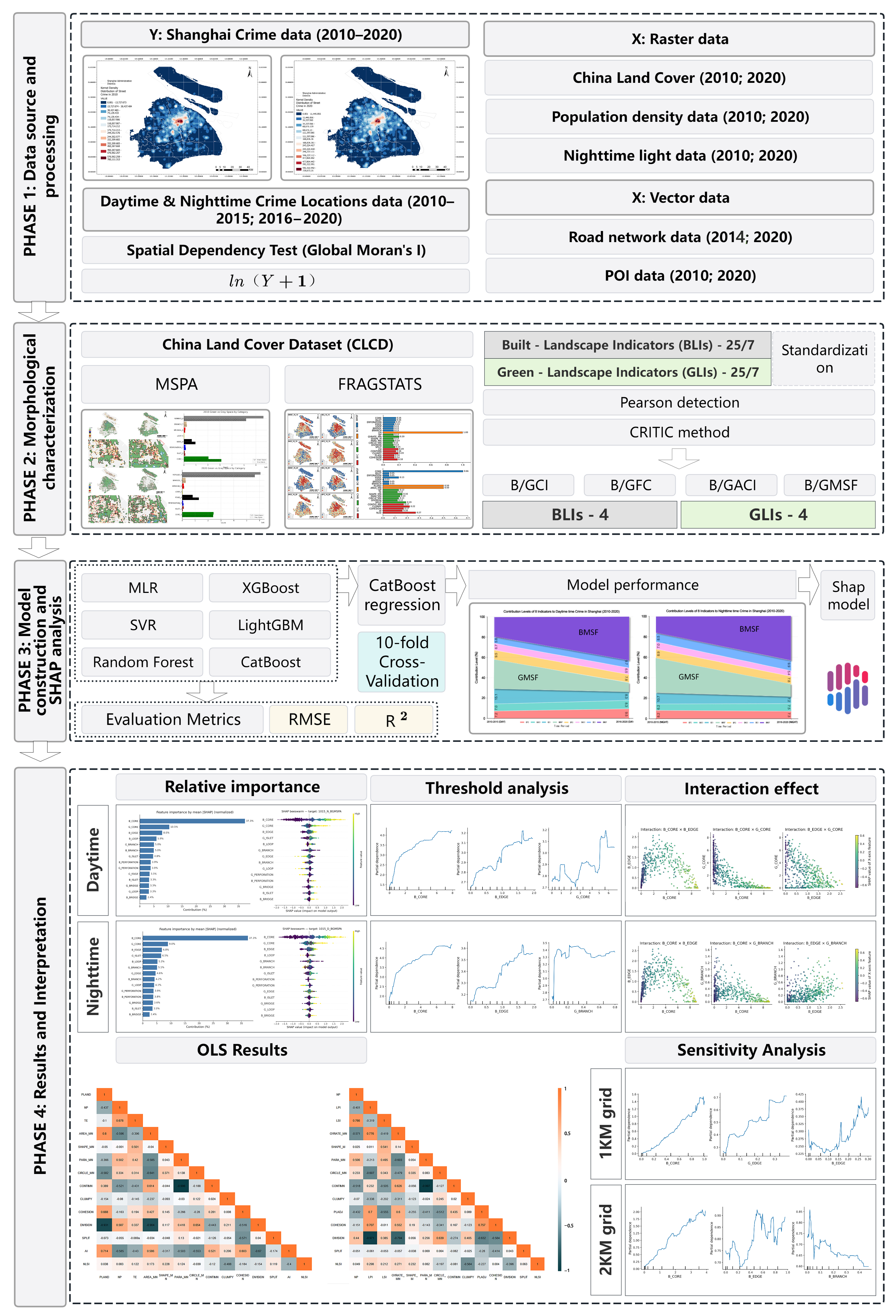
1.4. Research Framework and Questions
2. Research Area and Data
2.1. Research Area
2.2. Data
2.2.1. Development of Composite Indicators for Gray–Green Space
2.2.2. Overview of MSPA and FRAGSTATS Metrics
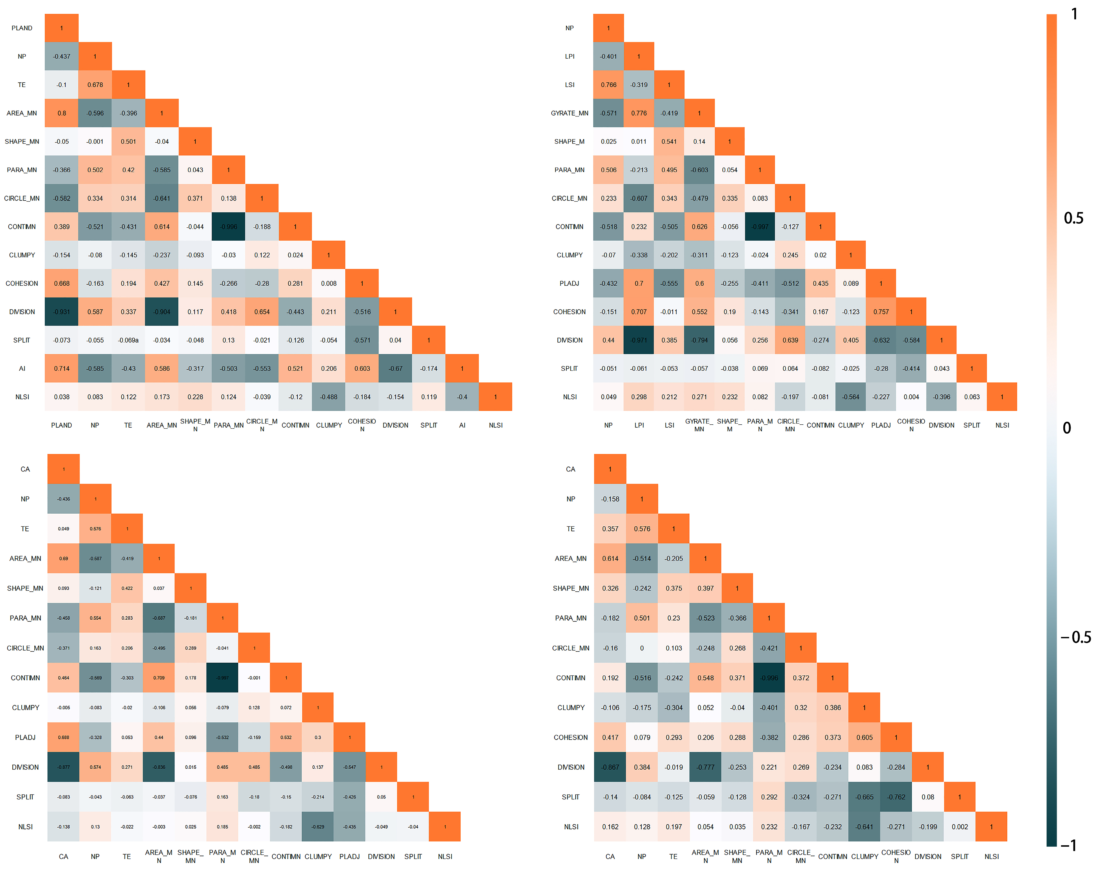
2.2.3. Pearson Correlation Analysis
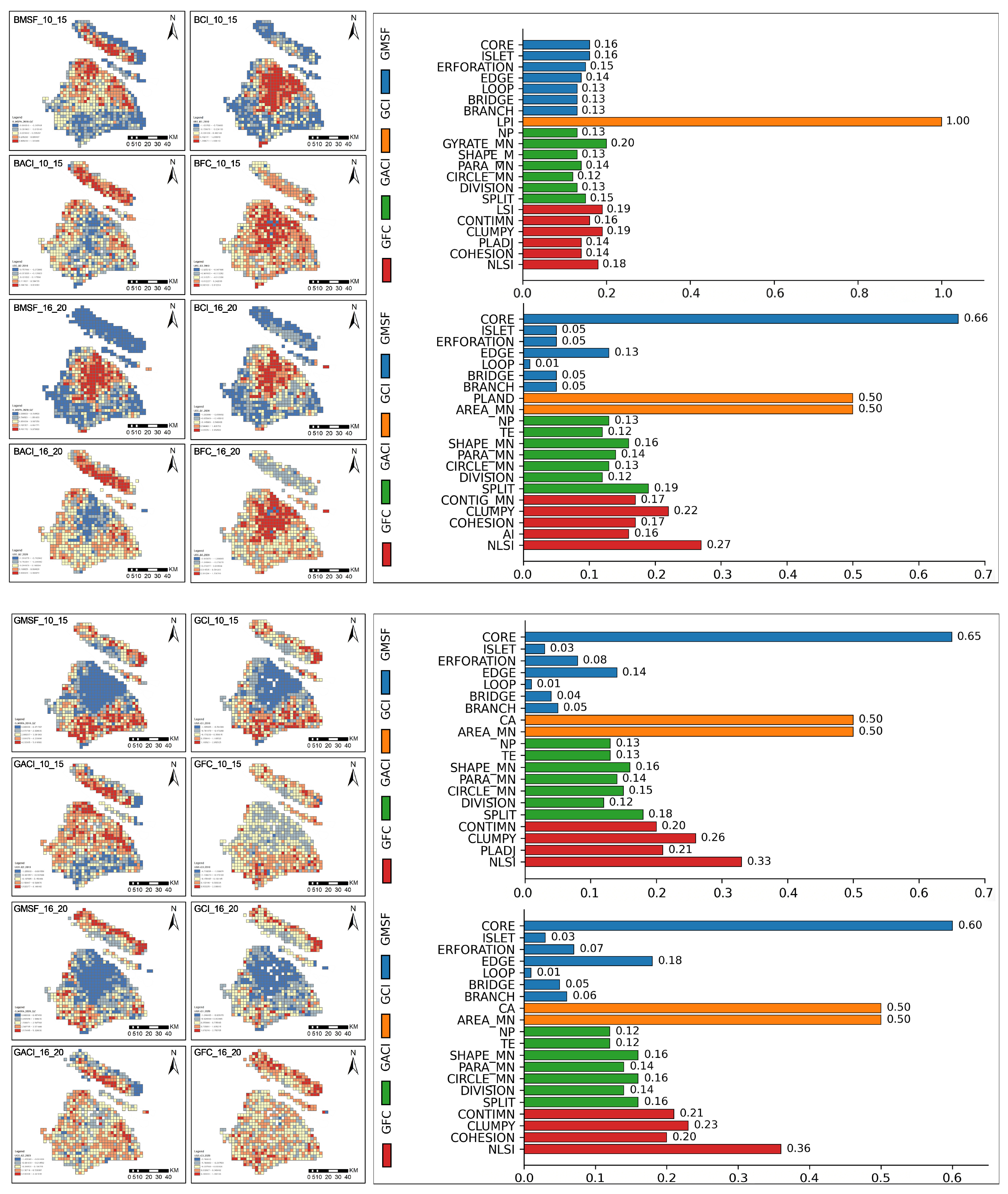
2.2.4. Composite Index Calculation
2.2.5. SHAP Explanation Method
2.3. Model Evaluation
3. Results
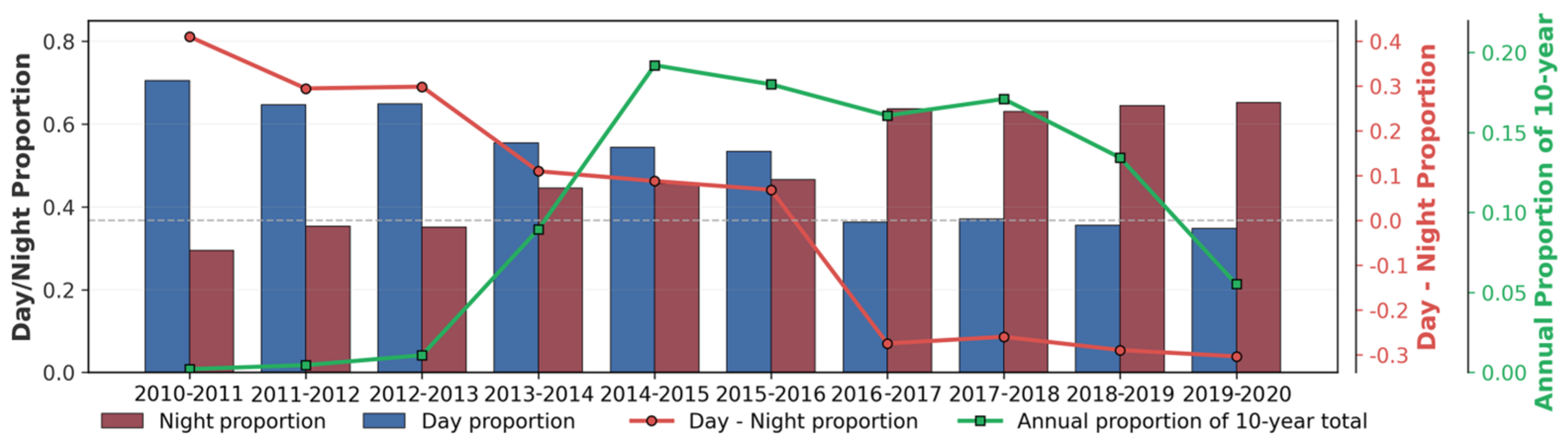
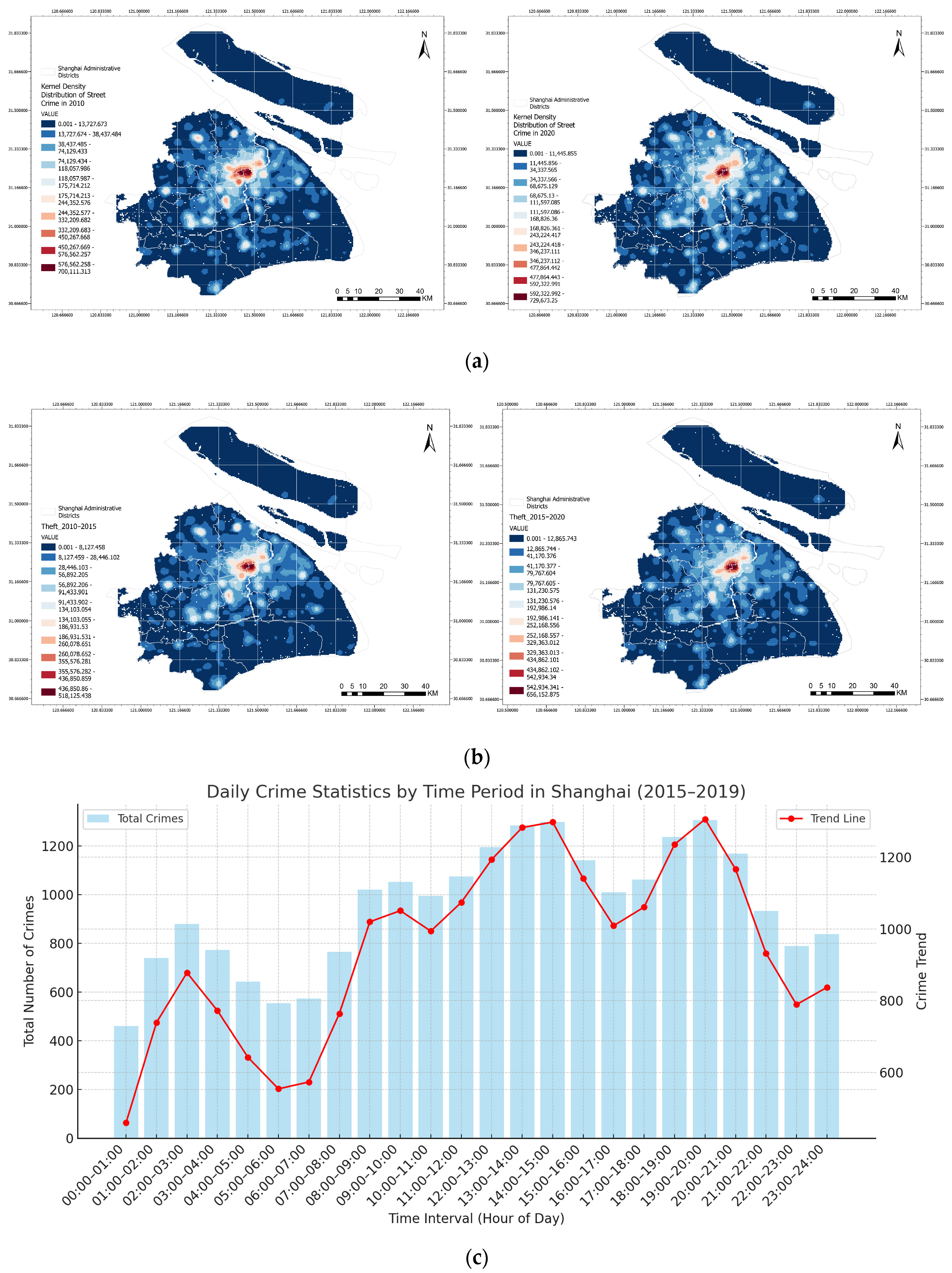
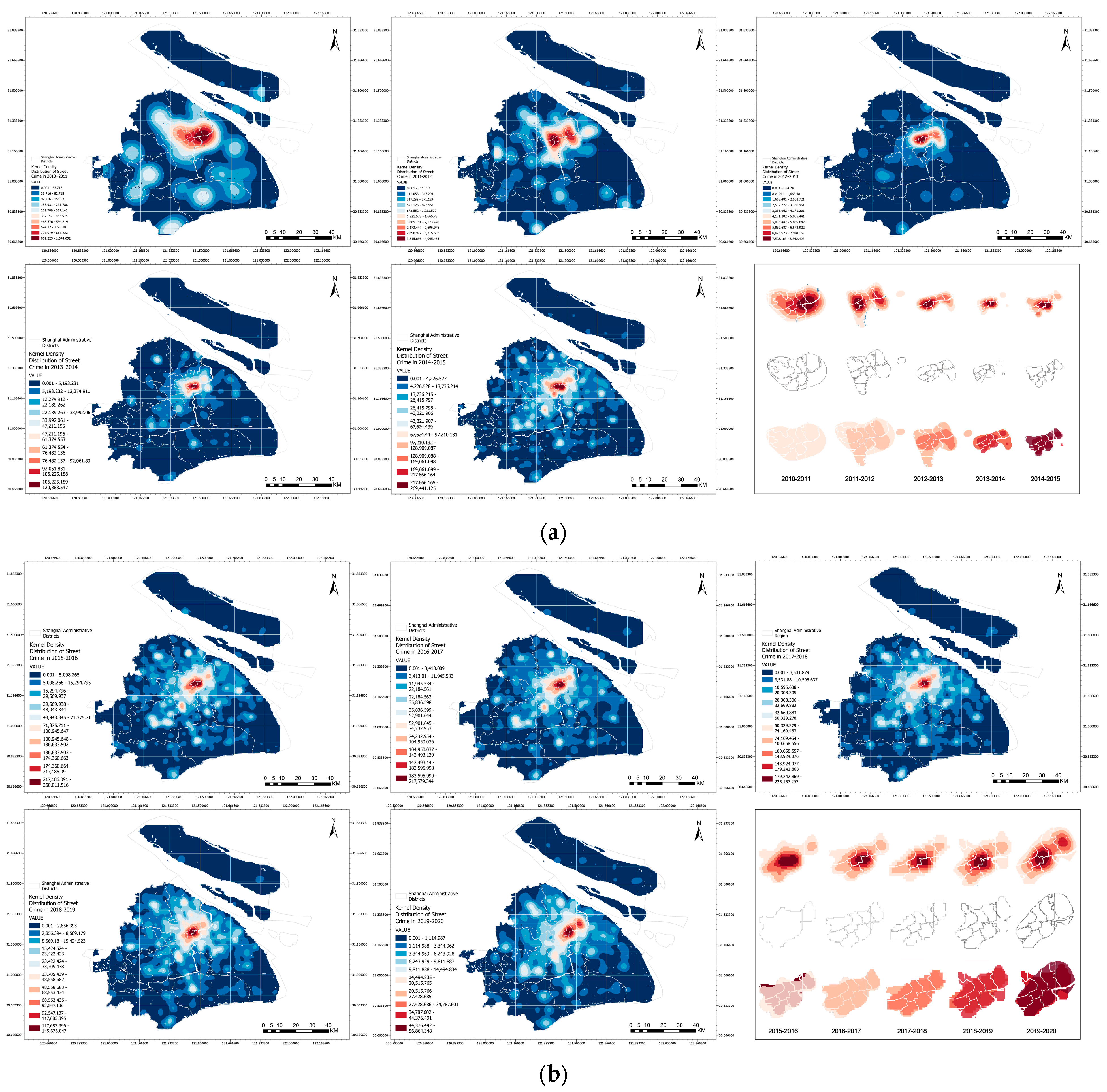
3.1. Overview of Crime Distribution
3.2. Spatial Feature Indicators
3.3. Analysis of CatBoost Model Results
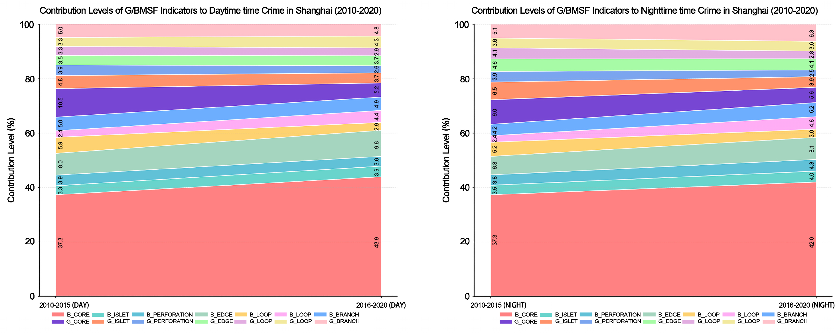
3.3.1. Analysis of Contribution Level Results
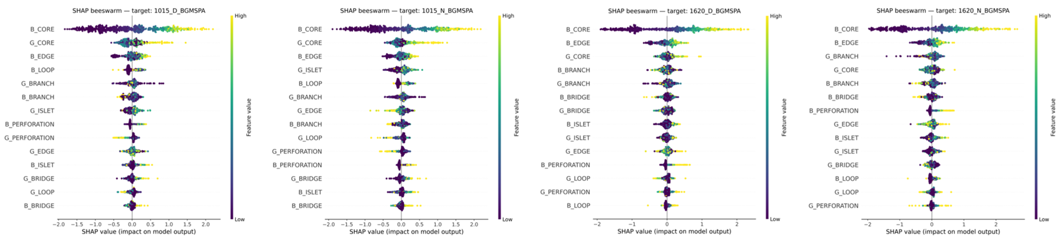
3.3.2. Analysis of SHAP Distribution Patterns
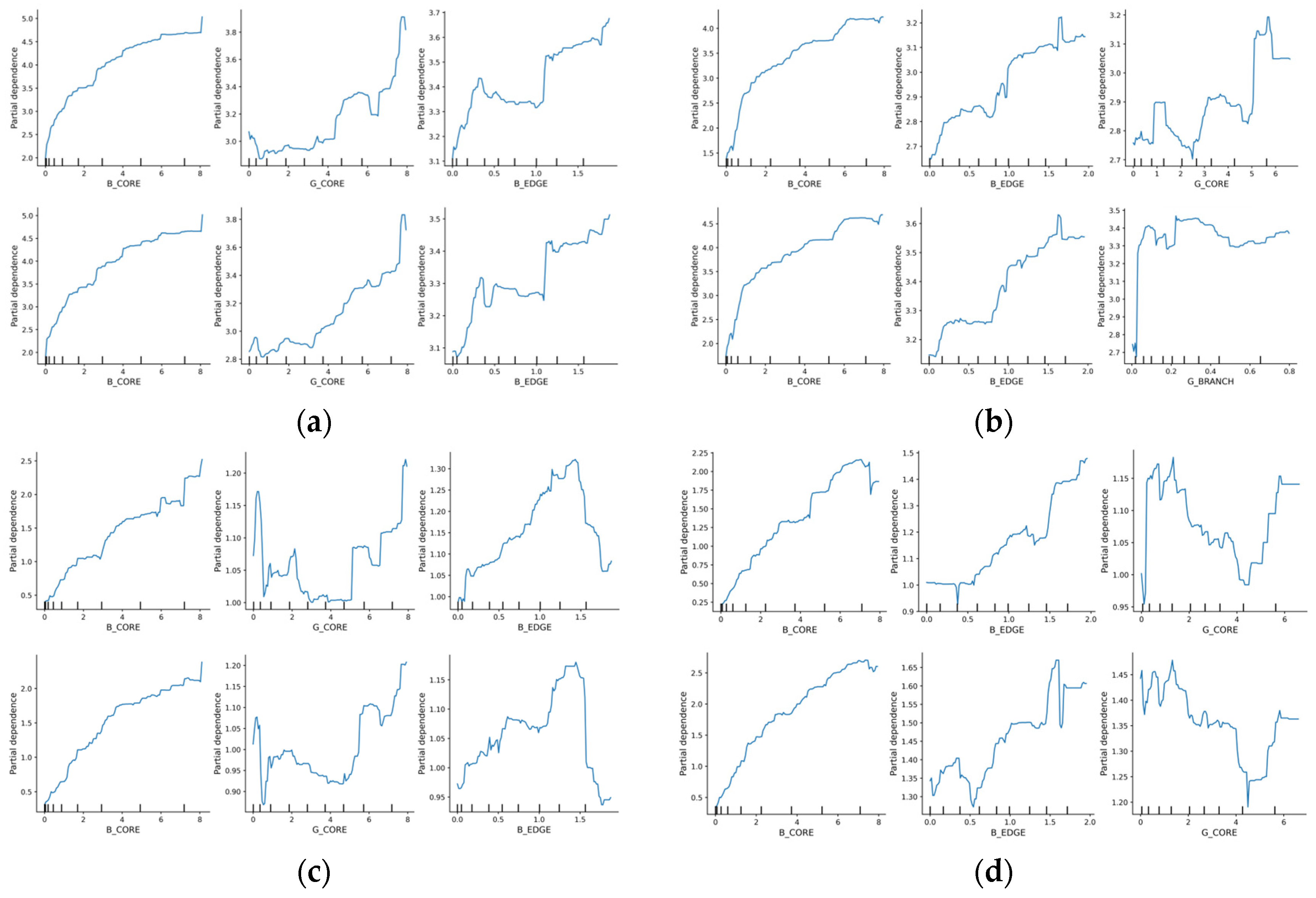
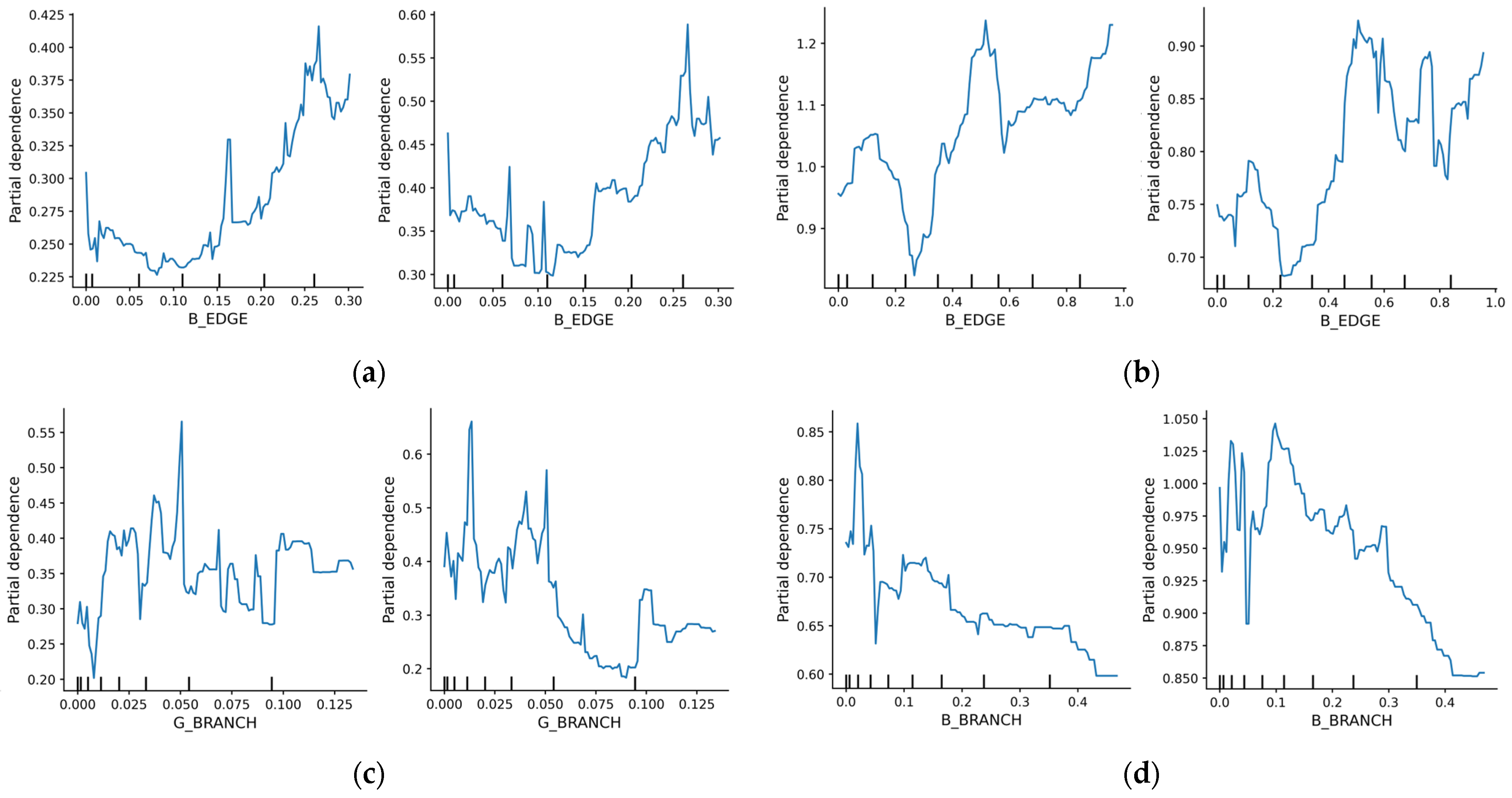
3.3.3. Threshold Response Characteristic Analysis
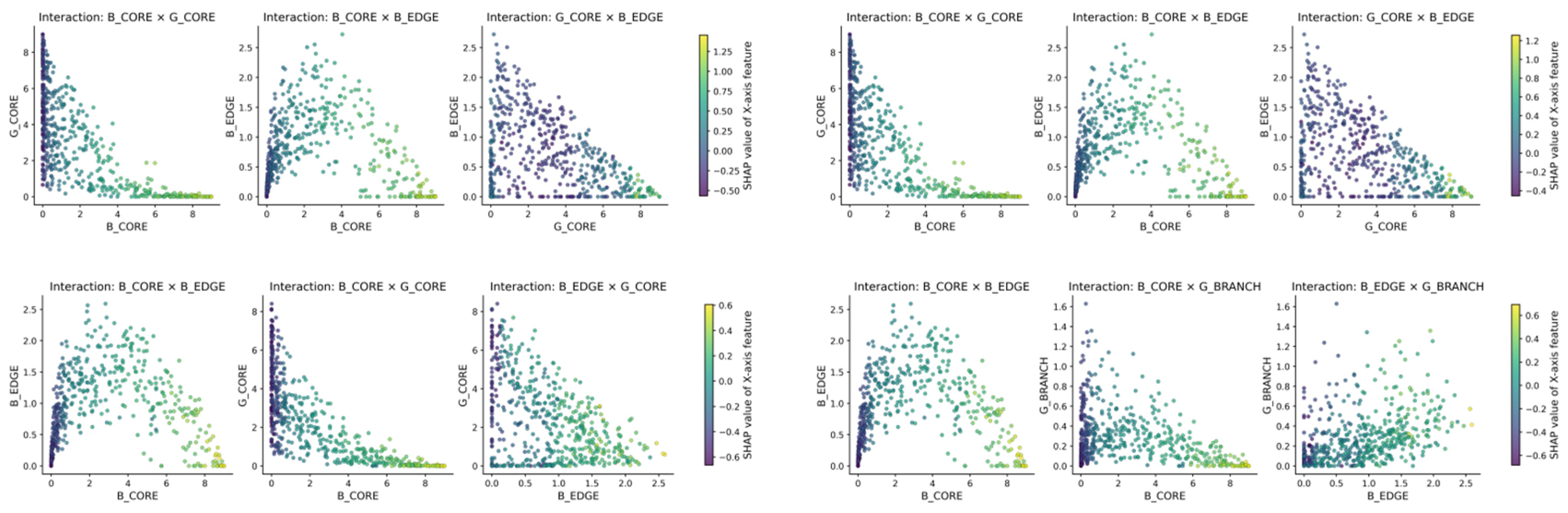
3.3.4. Characteristic Analysis of Interaction Effect
4. Discussion
4.1. Temporal Evolution of Street Crime Risk Types
4.2. Differences in Structural Indicators of Gray–Green Spaces
4.3. Coupling and Correlation of Gray–Green Spatial Forms
5. Conclusions
5.1. Research Contributions
5.2. Planning Implications and Policy Relevance
5.3. Research Shortcomings and Future Prospects
Author Contributions
Funding
Data Availability Statement
Acknowledgments
Conflicts of Interest
Appendix A

| NO. | Period | 2010–2015_D (Daytime) | 2010–2015_N (Nighttime) | 2016–2020_D (Daytime) | 2016–2020_N (Nighttime) | CCD | CCN |
|---|---|---|---|---|---|---|---|
| 1 | Other | 167 | 102 | 177 | 59 | −10 | 43 |
| 2 | Theft | 5365 | 4281 | 4813 | 8637 | 552 | −4356 |
| 3 | Snatching | 63 | 86 | 25 | 91 | 38 | −5 |
| 4 | Robbery | 179 | 352 | 72 | 292 | 107 | 60 |
| 5 | Fraud | 152 | 79 | 28 | 30 | 124 | 49 |
| 6 | Rape | 15 | 10 | 3 | 12 | 12 | −2 |
| 7 | Arson | 1 | 2 | 0 | 0 | 1 | 2 |
| 8 | Illegal Detention | 7 | 2 | 2 | 1 | 5 | 1 |
| 9 | Traffic-related | 6 | 9 | 4 | 10 | 2 | −1 |
| 10 | Intentional Homicide | 14 | 10 | 2 | 74 | 12 | −64 |
| 11 | Provoking Trouble | 17 | 39 | 8 | 58 | 9 | −19 |
| 12 | Intentional Injury | 29 | 34 | 14 | 45 | 15 | −11 |
| 13 | Drug-related | 67 | 50 | 14 | 38 | 53 | 12 |
| 14 | Criminal Offenses | 1637 | 1373 | 414 | 597 | 1223 | 776 |
Appendix B
| 2016–2020_D (Daytime) | 2016–2020_N (Nighttime) | |||
|---|---|---|---|---|
| Grid size | Test_R2 | Test_RMSE | Test_R2 | Test_RMSE |
| 3 KM | 0.665 | 0.823 | 0.686 | 0.882 |
| 2 KM | 0.542 | 0.67 | 0.561 | 0.78 |
| 1 KM | 0.306 | 0.499 | 0.402 | 0.592 |
Appendix C
Appendix D
| Period | Time | Mean R2 | SD | Mean RMSE |
|---|---|---|---|---|
| 2010–2015 | Daytime | 0.6644 | 0.0609 | 0.9181 |
| 2010–2015 | Nighttime | 0.6518 | 0.0487 | 0.9191 |
| 2016–2020 | Daytime | 0.6614 | 0.0486 | 0.9461 |
| 2015–2020 | Nighttime | 0.6657 | 0.0702 | 1.0505 |
Appendix E
| Temporal Cross-Section | Context | Moran’s I | Z-Score | p-Value |
|---|---|---|---|---|
| 2010–2015 | Daytime | 0.1125 | 23.75 | 0.0000 |
| 2010–2015 | Nighttime | 0.0859 | 10.69 | 0.0000 |
| 2016–2020 | Daytime | 0.0415 | 5.02 | 0.0000 |
| 2016–2020 | Nighttime | 0.0345 | 5.44 | 0.0000 |
Appendix F
| Algorithm A1. Integrated CatBoost–SHAP Analytical Framework |
| Input: |
| Composite gray–green indicators , log-transformed crime frequencies |
| Output: |
| Feature importance ranking, nonlinear threshold patterns, and interaction effects |
| Procedure: |
| 1. Initialize the hyperparameter search space for the CatBoost regressor. |
| 2. Perform a 10-fold cross-validation split on the 3 km grid dataset. |
| 3.: |
| -Train a CatBoost model using the RMSE objective function. |
| -Evaluate model performance on the validation fold using R2 and RMSE. |
| 4.. |
| 5. Apply the SHAP explainer to the trained CatBoost model. |
| 6. Compute SHAP values to quantify feature contributions. |
| 7. Generate SHAP dependence plots and interaction plots for gray–green variables. |
| 8. Identify nonlinear thresholds and interaction patterns. |
| Return: |
| Variable importance ranking and detected spatial threshold effects. |
References
- Lafortezza, R.; Sanesi, G. Nature-based solutions: Settling the issue of sustainable urbanization. Environ. Res. 2019, 172, 394–398. [Google Scholar] [CrossRef] [Scilit]
- Elsawy, A.A.; Ayad, H.M.; Saadallah, D. Assessing livability of residential streets—Case study: El-Attarin, Alexandria, Egypt. Alex. Eng. J. 2019, 58, 745–755. [Google Scholar] [CrossRef] [Scilit]
- Lawrence, M.; Homer-Dixon, T.; Janzwood, S.; Rockström, J.; Renn, O.; Donges, J.F. Global polycrisis: The causal mechanisms of crisis entanglement. Glob Sustain. 2024, 7, e6. [Google Scholar] [CrossRef] [Scilit]
- Charbonneau, B.; Giguère, A. The polycrisis and the uncertainty possibility space. Glob Sustain. 2025, 8, e4. [Google Scholar] [CrossRef] [Scilit]
- Oliver, T.H.; Doherty, B.; Dornelles, A.Z.; Greenwell, M.; Harrison, L.; Jones, I.; Lewis, A.; Moller, S.; Tovey, P.; Gilbert, N. Appraising cascading systemic risks, ‘watchpoints’, and interventions—Methodological reflections. Glob Sustain. 2026, 9, e4. [Google Scholar] [CrossRef] [Scilit]
- Brantingham, P.J.; Brantingham, P.L.; Andresen, M.A. The geometry of crime and crime pattern theory. J. Quant. Criminol. 2017, 33, 495–518. [Google Scholar]
- Curtis-Ham, S.; Bernasco, W.; Medvedev, O.N.; Polaschek, D. A framework for estimating crime location choice based on awareness space. Crime Sci. 2020, 9, 23. [Google Scholar] [CrossRef] [Scilit]
- Mao, Y.; Yin, L.; Zeng, M.; Ding, J.; Song, Y. Review of Empirical Studies on Relationship between Street Environment and Crime. J. Plan. Lit. 2021, 36, 187–202. [Google Scholar] [CrossRef] [Scilit]
- van Sleeuwen, S.E.M.; Ruiter, S.; Steenbeek, W. Right place, right time? Making crime pattern theory time-specific. Crime Sci. 2021, 10, 2. [Google Scholar] [CrossRef] [Scilit]
- Cadenasso, M.L.; Pickett, S.T.A.; Schwarz, K. Ecological Heterogeneity in Urban Ecosystems: Reconceptualized Land Cover Models as a Bridge to Urban Design. In Resilience in Ecology and Urban Design; Springer: Berlin/Heidelberg, Germany, 2013; Volume 3, pp. 107–127. [Google Scholar] [CrossRef] [Scilit]
- Zhou, W.; Huang, G.; Cadenasso, M.L. Does spatial configuration matter? Understanding the effects of land cover pattern on land surface temperature in urban landscapes. Landsc. Urban Plan. 2011, 102, 54–63. [Google Scholar] [CrossRef] [Scilit]
- Groff, E.R.; Lockwood, B. Criminogenic Facilities and Crime across Street Segments in Philadelphia: Uncovering Evidence about the Spatial Extent of Facility Influence. J. Res. Crime Delinq. 2014, 51, 277–314. [Google Scholar] [CrossRef] [Scilit]
- Brantingham, P.J.; Faust, F.L. A conceptual model of crime prevention. Crime Delinq. 1976, 22, 284–296. [Google Scholar] [CrossRef] [Scilit]
- Cohen, L.E.; Felson, M. Social change and crime rate trends: A routine activity approach. Am. Sociol. Rev. 1979, 44, 588–608. [Google Scholar] [CrossRef] [Scilit]
- Jacobs, J. The Death and Life of Great American Cities; Random House: New York, NY, USA, 1961. [Google Scholar]
- Newman, O. Defensible Space: People and Design in the Violent City; Architectural Press: London, UK, 1973; pp. 9–29. [Google Scholar]
- Jeffery, C.R. Crime Prevention Through Environmental Design; SAGE Publications: Thousand Oaks, CA, USA, 1997; pp. 186–206. [Google Scholar]
- Crowe, T.D. Crime Prevention Through Environmental Design; Elsevier: Oxford, UK, 2000; pp. 15–24. [Google Scholar]
- Mazzilli, C.T.S. Poetics of generative cartography. In Proceedings of the 14th Generative Art Conference (GA2011), Rome, Italy, 5–7 December 2011; pp. 495–503. [Google Scholar]
- Hanson, L.J. Cartographic Criminology: An Assessment and Proposal for an Integrated Approach to Crime Mapping. Ph.D. Thesis, University of Kent, Canterbury, UK, 2015. [Google Scholar]
- Linning, S.J.; Bowers, K.; Eck, J.E. Crime radiation theory: The co-production of crime patterns through opportunity creation and exploitation. Crime Sci. 2024, 13, 32. [Google Scholar] [CrossRef] [Scilit]
- Eck, J.E.; Linning, S.J.; Bowers, K. Does crime in places stay in places? Evidence for crime radiation from three narrative reviews. Aggress. Violent Behav. 2024, 78, 101955. [Google Scholar] [CrossRef] [Scilit]
- He, Z.; Zhang, Y.; Wang, Y.; Zhang, H.; Yao, X. Measuring the influence of multiscale geographic space on the heterogeneity of crime distribution. ISPRS Int. J. Geo-Inf. 2023, 12, 437. [Google Scholar] [CrossRef] [Scilit]
- Wang, Z.; Lu, J.; Beccarelli, P.; Yang, C. Neighbourhood permeability and burglary: A case study of a city in China. Intell. Build. Int. 2022, 14, 298–315. [Google Scholar] [CrossRef] [Scilit]
- Zeng, M.; Mao, Y.; Wang, C. The relationship between street environment and street crime: A case study of Pudong New Area, Shanghai, China. Cities 2021, 112, 103143. [Google Scholar] [CrossRef] [Scilit]
- Liu, K.; Zhang, L.; Tsou, S.; Wang, L.; Hu, Y.; Yang, K. Exploring the Complex Association Between Urban Built Environment, Sociodemographic Characteristics and Crime: Evidence from Washington, D.C. Land 2024, 13, 1886. [Google Scholar] [CrossRef] [Scilit]
- Burt, C.J.; Kondo, M.C.; Hohl, B.C.; Gong, C.H.; Bushman, G.; Wixom, C.; South, E.C.; Cunningham, R.M.; Carter, P.M.; Branas, C.C.; et al. Community Greening, Fear of Crime, and Mental Health Outcomes. Am. J. Community Psychol. 2022, 69, 46–58. [Google Scholar] [CrossRef] [Scilit] [PubMed]
- Li, B.; Li, G.; Lan, L.; Jin, A.; Lin, Z.; Wang, Y.; Chen, X. The influence mechanism of urban street environment on juvenile delinquency based on multi-source data fusion: A case study of Manhattan, New York. Comput. Urban Sci. 2024, 4, 26. [Google Scholar] [CrossRef] [Scilit]
- Mansourihanis, O.; Maghsoodi Tilaki, M.J.; Sheikhfarshi, S.; Mohseni, F.; Seyedebrahimi, E. Addressing Urban Management Challenges for Sustainable Development: Analyzing the Impact of Neighborhood Deprivation on Crime Distribution in Chicago. Societies 2024, 14, 139. [Google Scholar] [CrossRef] [Scilit]
- Dear, K.; Dutton, K.; Fox, E. Do ‘watching eyes’ influence antisocial behavior? A systematic review and meta-analysis. Evol. Hum. Behav. 2019, 40, 269–280. [Google Scholar] [CrossRef] [Scilit]
- Ceccato, V.; Gaudelet, N.; Graf, G. Crime and safety in transit environments: A systematic review of the English and the French literature, 1970–2020. Public Transp. 2022, 14, 105–153. [Google Scholar] [CrossRef] [Scilit]
- Ventorim, F.C.; Netto, V.M. The Hidden Connections of Urban Crime: A Network Analysis of Victims, Crime Types, and Locations in Rio de Janeiro. Urban Sci. 2024, 8, 72. [Google Scholar] [CrossRef] [Scilit]
- Roy, S. Visibility matters: Constructing safe passages on the streets of Kolkata. J. Urban Aff. 2024, 46, 1433–1451. [Google Scholar] [CrossRef] [Scilit]
- International CPTED Association. ICA Newsletters. Available online: https://www.cpted.net/ICA-newsletters (accessed on 15 January 2025).
- Fujii, T.; Fujikawa, Y.; Oikawa, K. A quantitative analysis of natural surveillance at elementary schools. J. Asian Archit. Build. Eng. 2013, 12, 17–23. [Google Scholar] [CrossRef] [Scilit]
- Jing, F.; Liu, L.; Zhou, S.; Song, J.; Wang, L.; Zhou, H.; Wang, Y.; Ma, R. Assessing the Impact of Street-View Greenery on Fear of Neighborhood Crime in Guangzhou, China. Int. J. Environ. Res. Public Health 2021, 18, 311. [Google Scholar] [CrossRef] [Scilit]
- Oh, H.-N.; Kang, S.-J. A study on crime characteristics and CPTED application of neighborhood walking trails. J. Archit. Inst. Korea 2025, 41, 103–112. [Google Scholar]
- Gu, H.; Sui, J.; Chen, P. Graph Representation Learning for Street-Level Crime Prediction. ISPRS Int. J. Geo-Inf. 2024, 13, 229. [Google Scholar] [CrossRef] [Scilit]
- Mao, Y.; Dai, S.; Ding, J.; Zhu, W.; Wang, C.; Ye, X. Space–Time Analysis of Vehicle Theft Patterns in Shanghai, China. ISPRS Int. J. Geo-Inf. 2018, 7, 357. [Google Scholar] [CrossRef] [Scilit]
- Cheng, W.; Rao, Y.; Tang, Y.; Yang, J.; Chen, Y.; Peng, L.; Hao, J. Identifying the Spatio-Temporal Characteristics of Crime in Liangshan Prefecture, China. Int. J. Environ. Res. Public Health 2022, 19, 10862. [Google Scholar] [CrossRef] [Scilit]
- Zhang, H.; Gao, Y.; Yao, D.; Zhang, J. Interaction of Crime Risk across Crime Types in Hotspot Areas. ISPRS Int. J. Geo-Inf. 2023, 12, 176. [Google Scholar] [CrossRef] [Scilit]
- Clutter, J.E.; Peterson, S.; Henderson, S.; Haberman, C.P. Understanding the impact of weather and potentially criminogenic places on street robbery. Crime Sci. 2024, 13, 42. [Google Scholar] [CrossRef] [Scilit]
- Jonescu, E.E.; Ramanayaka, C.E.; Olatunji, O.A.; Uylaki, T.J. Understanding the impact of urban heat islands on crime: Insights from temperature, population density, and green canopy cover. Crime Sci. 2024, 13, 15. [Google Scholar] [CrossRef] [Scilit]
- Zou, Y.; Chen, J.; Zong, H. Is shading a better way to cool down? Evaluation and comparison of the cooling capacity of blue-green spaces and urban shade. Ecol. Indic. 2024, 167, 112688. [Google Scholar] [CrossRef] [Scilit]
- Cozens, P.; Love, T.; Davern, B. Geographical Juxtaposition: A New Direction in CPTED. Soc. Sci. 2019, 8, 252. [Google Scholar] [CrossRef] [Scilit]
- Kim, G.; Cho, Y.; Han, Y.; Lee, G. Crime mapping in urban environments using explainable AI: A case study of Daegu, Korea. Sustain. Cities Soc. 2025, 130, 106507. [Google Scholar] [CrossRef] [Scilit]
- Sampson, R.J.; Groves, W.B. Community structure and crime: Testing social-disorganization theory. Am. J. Sociol. 1989, 94, 774–802. [Google Scholar] [CrossRef] [Scilit]
- Guerette, R.T.; Bowers, K. Assessing the extent of crime displacement and diffusion of benefits. Criminology 2009, 47, 1331–1368. [Google Scholar] [CrossRef] [Scilit]
- Han, Z.; Xie, W.; Jiang, R.; Huang, Q.; Chen, T.; Chen, R. Relationship between the street spatial environment and crime based on quantitative network analysis. Proc. ACM Hum.-Comput. Interact. 2024, 8, 3708230. [Google Scholar]
- Awaryi Churchill, S.; Hayward, M.; Smyth, R.; Trinh, T. Crime, community social capital and entrepreneurship. J. Bus. Ventur. 2023, 38, 106291. [Google Scholar] [CrossRef] [Scilit]
- Andresen, M.A.; Frank, R.; Felson, M. Age and the distance to crime. Criminol. Crim. Justice 2013, 14, 314–333. [Google Scholar] [CrossRef] [Scilit]
- Weisburd, D.; Zastrow, T.; Kuen, K.; Andresen, M.A. Crime concentrations at micro places: A review of the evidence. Aggress. Violent Behav. 2024, 78, 101979. [Google Scholar] [CrossRef] [Scilit]
- Troy, A.; Morgan Grove, J.; O’Neil-Dunne, J. The relationship between tree canopy and crime rates across an urban–rural gradient in the greater Baltimore region. Landsc. Urban Plan. 2012, 106, 262–270. [Google Scholar] [CrossRef] [Scilit]
- Othman, F.; Mohd Yusoff, Z.; Abdul Rasam, A.R. Isovist and visibility graph analysis (VGA): Strategies to evaluate visibility along movement pattern for safe space. IOP Conf. Ser. Earth Environ. Sci. 2019, 385, 012024. [Google Scholar] [CrossRef] [Scilit]
- Chen, Y.; Li, Y.; Li, J. Investigating the Influence of Tree Coverage on Property Crime: A Case Study in the City of Vancouver, British Columbia, Canada. ISPRS Int. Arch. Photogramm. Remote Sens. Spatial Inf. Sci. 2016, XLI-B2, 695–702. [Google Scholar] [CrossRef] [Scilit]
- Venter, Z.S.; Shackleton, C.; Faull, A.; Lancaster, L.; Breetzke, G.; Edelstein, I. Is green space associated with reduced crime? A national-scale study from the Global South. Sci. Total Environ. 2022, 825, 154005. [Google Scholar] [CrossRef] [Scilit]
- Schertz, K.E.; Saxon, J.; Cardenas-Iniguez, C.; Bettencourt, L.M.A.; Ding, Y.; Hoffmann, H.; Berman, M.G. Neighborhood street activity and greenspace usage uniquely contribute to predicting crime. npj Urban Sustain. 2021, 1, 19. [Google Scholar] [CrossRef] [Scilit]
- Wang, X.; Zhou, L.; López-Carr, D.; Song, Y.; Gao, H.; Che, T.; Liu, Z.; Wei, W. Urban grey-green scales: A new perspective for assessing dynamic spatial trade-offs. Int. J. Appl. Earth Obs. Geoinf. 2025, 142, 104808. [Google Scholar] [CrossRef] [Scilit]
- Caplan, J.M.; Kennedy, L.W.; Piza, E.L. Environmental crime enforcement: Assessing the impact of police activity on violations. J. Environ. Manag. 2013, 128, 843–851. [Google Scholar]
- Caplan, J.M.; Piza, E.L.; Kennedy, L.W. Citizen reporting of environmental crime. Crime Prev. Community Saf. 2013, 15, 187–205. [Google Scholar]
- Anyinam, K. Transnational environmental crime in Africa: Challenges and opportunities for regional cooperation. J. Environ. Law Policy 2015, 24, 163–188. [Google Scholar]
- Zhang, Y.; Kwan, M.-P.; Fang, L. An LLM driven dataset on the spatiotemporal distributions of street and neighborhood crime in China. Sci. Data 2025, 12, 467. [Google Scholar] [CrossRef] [Scilit] [PubMed]
- Chen, Z.; Yu, B.; Yang, C.; Zhou, Y.; Yao, S.; Yao, S.; Qian, X.; Wang, C.; Wu, B.; Wu, J. An Extended Time Series (2000–2018) of Global NPP-VIIRS-Like Nighttime Light Data from a Cross-Sensor Calibration. Remote Sens. 2021, 13, 889. [Google Scholar] [CrossRef] [Scilit]
- Soille, P.; Vogt, P. Morphological segmentation of binary patterns. Pattern Recognit. Lett. 2009, 30, 456–459. [Google Scholar] [CrossRef] [Scilit]
- Vogt, P.; Larondelle, N.; Giordano, B. Morphological spatial pattern analysis (MSPA) for detecting forest cover patterns in raster maps. Landsc. Ecol. 2007, 23, 1107–1117. [Google Scholar]
- Li, H.; Wu, J. Use and misuse of landscape indices. Landsc. Ecol. 2004, 19, 389–399. [Google Scholar] [CrossRef] [Scilit]
- McGarigal, K.; Cushman, S.A.; Ene, E. FRAGSTATS v4: Spatial Pattern Analysis Program for Categorical and Continuous Maps; University of Massachusetts: Amherst, MA, USA, 2012. [Google Scholar]
- Dormann, C.F.; Elith, J.; Bacher, S.; Buchmann, C.; Carl, G.; Carré, G.C.G.; Márquez, J.R.G.; Gruber, B.; Lafourcade, B.; Leitao, P.J.; et al. Collinearity: A review of methods to deal with it and a simulation study evaluating their performance. Ecography 2013, 36, 27–46. [Google Scholar] [CrossRef] [Scilit]
- Lundberg, S.M.; Lee, S.-I. A unified approach to interpreting model predictions. In Proceedings of the 31st International Conference on Neural Information Processing Systems, Long Beach, CA, USA, 4–9 December 2017; pp. 4768–4777. [Google Scholar]
- Hoang, N.D. Machine learning approaches for geospatial modeling of urban land surface temperature. Sensors 2025, 25, 5380. [Google Scholar] [CrossRef] [Scilit]
- Liu, Q.; Hang, T.; Wu, Y. Unveiling differential impacts of multidimensional urban morphology on heat island effect across local climate zones. Build. Environ. 2025, 270, 112574. [Google Scholar] [CrossRef] [Scilit]
- Saraiva, M.; Teixeira, B. Exploring the spatial relationship between street crime events and the distribution of urban greenspace: The case of Porto, Portugal. ISPRS Int. J. Geo-Inf. 2023, 12, 492. [Google Scholar] [CrossRef] [Scilit]
- Li, D.; Han, H.Z.; Wang, J.; Xiao, X. Explaining Urban Vitality Through Interpretable Machine Learning: A Big Data Approach Using Street View Images and Environmental Factors. Sustainability 2025, 17, 4962. [Google Scholar] [CrossRef] [Scilit]



| Variable Category | Specific Indicator | Period 1: 2010–2015 | Period 2: 2016–2020 | Resolution | Source |
|---|---|---|---|---|---|
| Dependent Variable | Daytime & Nighttime Street Crime | Aggregated incidents (2010–2015) | Aggregated incidents (2016–2020) | Dataset | https://doi.org/10.6084/m9.figshare.28106939 (accessed on 31 March 2026) |
| Independent Variables | Variables Land Cover (GlobeLand30) | 2010 dataset | 2020 dataset | Raster (30 m) | https://www.un-spider.org/links-and-resources/data-sources/land-cover-map-globeland-30-ngcc (accessed on 31 March 2026) |
| Environmental Covariates | Nighttime Lights (NTL) | 2010 dataset | 2020 dataset | Raster (100 m) | https://doi.org/10.7910/DVN/YGIVCD (accessed on 31 March 2026) |
| Environmental Covariates | Road Network (OSM) | 2014 Historical Extract | 2020 Historical Extract | Vector (polyline) | Open Street Map (OSM) |
| Environmental Covariates | POI data | 2010 dataset | 2020 dataset | Vector (point) | Gaode (Amap) |
| Environmental Covariates | Population Density Data | 2010 dataset | 2020 dataset | Raster (~500 m) | https://dx.doi.org/10.5258/SOTON/WP00645 (accessed on 31 March 2026) |
| Model Category | Model | Standard (TEST) | 2010–2015 (Day) | 2010–2015 (Night) | 2016–2020 (Day) | 2016–2020 (Night) | Note |
|---|---|---|---|---|---|---|---|
| Linear models | MLR | R2 | 0.303 | 0.203 | 0.608 | 0.619 | Low R2 |
| RMSE | 1.166 | 0.993 | 0.889 | 0.972 | High RMSE | ||
| Kernel- and distance-based models | SVR | R2 | 0.413 | 0.293 | 0.601 | 0.612 | Low R2 |
| RMSE | 1.069 | 0.936 | 0.898 | 0.982 | High RMSE | ||
| Ensemble tree-based models | Random Forest | R2 | 0.531 | 0.493 | 0.662 | 0.669 | Comparable to CatBoost |
| RMSE | 0.956 | 0.957 | 0.826 | 0.906 | High RMSE | ||
| XGBoost | R2 | 0.507 | 0.488 | 0.652 | 0.663 | Low R2 | |
| RMSE | 0.98 | 0.962 | 0.838 | 0.914 | High RMSE | ||
| LightGBM | R2 | 0.5 | 0.439 | 0.659 | 0.68 | Low R2 | |
| RMSE | 0.987 | 1.006 | 0.829 | 0.892 | High RMSE | ||
| CatBoost | R2 | 0.517 | 0.487 | 0.665 | 0.686 | Relatively good performance | |
| RMSE | 0.97 | 0.963 | 0.823 | 0.882 | Relatively good performance |
| Period | Train_R2 | Test_R2 | Test_RMSE | |||
|---|---|---|---|---|---|---|
| Landscape-Level Configuration Indicators | MSPA Structural Unit–Level Indicators | Landscape-Level Configuration Indicators | MSPA Structural Unit–Level Indicators | Landscape-Level Configuration Indicators | MSPA Structural Unit–Level Indicators | |
| 10_15_D | 0.824 | 0.866 | 0.517 | 0.687 | 0.970 | 0.925 |
| 10_15_N | 0.819 | 0.856 | 0.487 | 0.704 | 0.963 | 0.867 |
| 16_20_D | 0.847 | 0.967 | 0.665 | 0.672 | 0.823 | 0.923 |
| 16_20_N | 0.849 | 0.970 | 0.686 | 0.697 | 0.882 | 1.015 |
Disclaimer/Publisher’s Note: The statements, opinions and data contained in all publications are solely those of the individual author(s) and contributor(s) and not of MDPI and/or the editor(s). MDPI and/or the editor(s) disclaim responsibility for any injury to people or property resulting from any ideas, methods, instructions or products referred to in the content. |
© 2026 by the authors. Published by MDPI on behalf of the International Society for Photogrammetry and Remote Sensing. Licensee MDPI, Basel, Switzerland. This article is an open access article distributed under the terms and conditions of the Creative Commons Attribution (CC BY) license.
Share and Cite
Gu, X.; Seo, J. Gray–Green Spatial Structure and Nonlinear Threshold Effects on Street Crime: A CatBoost-Based Analysis of Day–Night Patterns in Shanghai. ISPRS Int. J. Geo-Inf. 2026, 15, 156. https://doi.org/10.3390/ijgi15040156
Gu X, Seo J. Gray–Green Spatial Structure and Nonlinear Threshold Effects on Street Crime: A CatBoost-Based Analysis of Day–Night Patterns in Shanghai. ISPRS International Journal of Geo-Information. 2026; 15(4):156. https://doi.org/10.3390/ijgi15040156
Chicago/Turabian StyleGu, Xuefei, and Jieun Seo. 2026. "Gray–Green Spatial Structure and Nonlinear Threshold Effects on Street Crime: A CatBoost-Based Analysis of Day–Night Patterns in Shanghai" ISPRS International Journal of Geo-Information 15, no. 4: 156. https://doi.org/10.3390/ijgi15040156
APA StyleGu, X., & Seo, J. (2026). Gray–Green Spatial Structure and Nonlinear Threshold Effects on Street Crime: A CatBoost-Based Analysis of Day–Night Patterns in Shanghai. ISPRS International Journal of Geo-Information, 15(4), 156. https://doi.org/10.3390/ijgi15040156