Article

Integrating GIS, Climate Hazards, and Gender Safety in Railway Networks: A Spatial Vulnerability Analysis of Serbia


by
Aleksandar Valjarević
1,
Milan Luković
2,*,
Dragana Radivojević
2,
Kh Md Nahiduzzaman
3,
Hassan Radoine
3,
Tiziana Campisi
4,
Celestina Fazia
4,
Dejan Filipović
1 and
Dragana Valjarević
5
1
Faculty of Belgrade, University of Belgrade, Studentski Trg 3/III, 11000 Belgarde, Serbia
2
Faculty of Education, University of East Sarajevo, Semberskih Ratara 1E, 76300 Bijeljina, Bosnia and Herzegovina
3
Citinnov for Integrated Territorial Planning & Smart Cities, Mohammed VI Polytechnic University (UM6P), Rabat 11103, Morocco
4
Faculty of Engineering and Architecture, University of Enna “Kore”, 94100 Enna, Italy
5
Faculty of Natural Sciences and Mathematics, University of Priština in Kosovska Mitrovica, Ive Lole Ribara 29, 38220 Kosovska Mitrovica, Serbia
*
Author to whom correspondence should be addressed.
ISPRS Int. J. Geo-Inf. 2026, 15(4), 152; https://doi.org/10.3390/ijgi15040152
Submission received: 22 February 2026 / Revised: 23 March 2026 / Accepted: 31 March 2026 / Published: 2 April 2026

Abstract

Railway transport plays a crucial role in sustainable and low-carbon mobility; however, the safety and resilience of railway systems are increasingly challenged by aging infrastructure, spatial inequality, and intensifying climate extremes. These challenges are particularly evident in Serbia, where railway stations in rural and peripheral areas often lack adequate safety infrastructure, accessibility, and climate-adaptive design, especially affecting women and other vulnerable passengers. The aim of this study is to develop a GIS-based spatial framework for assessing gender-sensitive railway safety under combined sociospatial and environmental pressures. The analysis integrates multiple geo-information sources, including railway infrastructure data, passenger statistics, safety incidents, and climate hazard indicators such as floods, heatwaves, heavy snowfall, and windstorms. Geographic Information System (GIS) techniques, including kernel density estimation, buffer and zonal statistics, spatial interpolation, and spatial regression, were applied to evaluate spatial safety patterns and environmental risks. The results reveal pronounced regional disparities, with southern and eastern Serbia representing the most vulnerable areas due to inactive stations, poor lighting, limited digital connectivity, and frequent exposure to extreme weather events. Rural railway stations are frequently located in climate risk zones, and many do not meet the minimum safety infrastructure standards. Based on these findings, this study recommends strengthening station lighting and surveillance systems, improving digital connectivity and emergency accessibility, and integrating climate-resilient infrastructure planning into railway modernization strategies. Overall, the findings highlight the importance of combining GIS-based spatial analysis, climate hazard assessment, and gender-sensitive planning to support safer, more inclusive, and climate-resilient railway infrastructure in Serbia.

1. Introduction

Transportation systems in many countries, like Serbia, were initially designed by men, primarily for men. Studies have revealed a significant gender gap in mobility across various European and non-European contexts [1]. This gap stems from both travel motivations and safety concerns during travel or near transportation modes, particularly impacting women’s ability to travel alone in certain non-European regions [2,3].
Railway transport represents one of the most sustainable modes of transport in modern mobility systems. According to international transport statistics, railways account for less than 2% of global transport-related CO2 emissions while transporting more than 8% of global passengers and freight. Because of their high energy efficiency and lower environmental impact compared with road transport, railway systems are considered a key component of sustainable and low-carbon transportation strategies promoted by international organizations such as the European Union and the United Nations. Strengthening railway infrastructure therefore represents a crucial step toward achieving climate-neutral and -resilient transport systems. However, despite their strategic importance, many railway systems in transitional economies face significant structural challenges. In Serbia, railway infrastructure has been affected by decades of insufficient investment, resulting in aging stations, limited digital infrastructure, poor lighting conditions, and inadequate safety systems. These weaknesses are further intensified by climate-related hazards such as floods, heatwaves, heavy snowfall, and strong winds, which can disrupt railway operations and increase safety risks for passengers. There are studies that also indicate critical safety issues for female passengers using rail and metro transport systems [4,5]. Railways, historically known for their affordability, luxury, and safety, pose challenges for governments worldwide in ensuring passenger safety [6,7,8]. Railway development in Serbia began in the late nineteenth century and expanded significantly during the twentieth century. However, following the political and economic transition after the 1990s, investment in railway infrastructure declined, leading to infrastructure aging and operational challenges that still affect the system today [9,10,11,12,13,14,15,16].
Although previous studies have examined railway safety, transportation infrastructure, and gender-related mobility issues, most research has focused either on technical infrastructure performance or on the social aspects of passenger safety separately. Only a limited number of studies have integrated Geographic Information Systems (GISs), climate hazard assessment, and gender-sensitive safety analysis within a unified spatial framework. Furthermore, such integrated spatial analyses remain particularly scarce in Southeastern Europe and Serbia, where railway infrastructure faces simultaneous challenges related to aging infrastructure, regional disparities, and increasing climate extremes. Consequently, there is a clear need for a comprehensive spatial approach that combines infrastructure conditions, environmental risks, and gender-sensitive safety indicators in order to better understand railway vulnerability and support evidence-based transport planning. The main aim of this study is to develop and apply a GIS-based spatial analytical framework for assessing railway safety vulnerabilities in Serbia by integrating infrastructure conditions, climate hazard exposure, and gender-related safety factors.
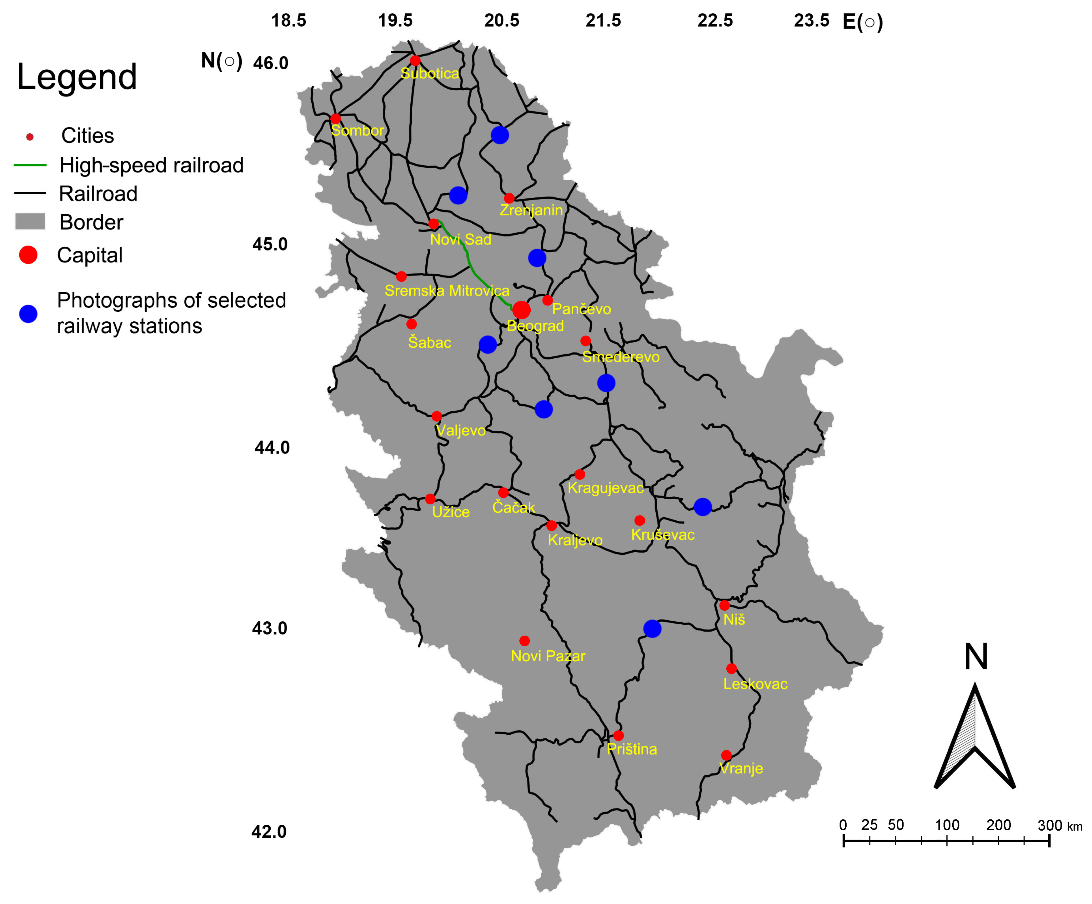
However, despite advancements, Serbian railways face challenges due to decades of inadequate infrastructure investment. The reconstruction of old railways has been hampered, with approval lacking across the country [17]. The total railway network in Serbia spans 4093 km, with 3526 km of single-track railways and 283 km of double-track ones, while 1287 km is electrified (see Figure 1). Addressing these challenges is vital for the sustainable development of Serbia’s railway infrastructure.
In the past five years, a significant number of rail service providers have ceased operations, particularly those offering local services, accounting for 35%. This trend has led to a transportation landscape heavily dominated by cars and buses, posing affordability challenges for the low-income population. While recent initiatives aim to improve regional railways, with plans to increase average speeds by 40% over the next three years [18], concerns persist regarding the safety of Serbia’s railway network over the past decade. Incidents of criminal activity near railway networks and stations have been on the rise, highlighting the urgency to address safety issues [19,20]. Of particular concern is the involvement of women as perpetrators in over 60% of cases, ranging from extreme weather to accidents involving trains [21,22]. The reliance on incomplete criminal records underscores the need for alternative data sources, with only 30% of police data currently digitized. Geographic Information System (GIS) offer valuable tools for analyzing traffic incidents and identifying high-potential hot spots (HPHSs), where various parameters such as accident frequency and severity are assessed [23,24,25,26]. GIS analysis aids in pinpointing areas prone to incidents, enabling proactive measures to enhance safety [27]. As traffic volumes surge, especially on railways and roads, GIS emerges as a vital tool for managing and analyzing traffic patterns, utilizing spatial statistical methods to categorize incidents by severity [28]. Given the paramount importance of analyzing road and railway traffic, particularly concerning air pollution, leveraging GIS tools becomes imperative. While basic GIS tools facilitate fundamental analyses of transportation networks, advanced methods such as buffer and zonal statistic procedures offer deeper insights into traffic patterns [29,30,31,32,33]. Therefore, adopting advanced GIS techniques is essential for comprehensively assessing and managing the safety and efficiency of Serbia’s transportation infrastructure, with a focus on ensuring the safety of passengers. Although previous studies have investigated railway safety and transportation systems using statistical and engineering approaches, only a limited number of studies have integrated Geographic Information System (GIS), climate hazard analysis, and gender-sensitive safety assessments. In particular, such integrated spatial analyses remain rare in the context of Southeastern Europe and Serbia. This lack of spatially explicit research limits the ability of policymakers and planners to identify vulnerable railway zones and to design targeted interventions for improving passenger safety.
Therefore, the main objective of this study is to evaluate spatial vulnerabilities in Serbia’s railway network using a GIS-based analytical framework. Specifically, this study aims to:
(1) Identify the spatial patterns of railway safety risks.
(2) Assess the influence of infrastructure conditions and climate hazards on passenger safety.
(3) Propose spatially targeted solutions to improve safety and resilience in the railway system, particularly for vulnerable passenger groups such as women. The findings of this study contribute to broader international efforts aimed at improving sustainable and resilient transport systems. In particular, the results support the objectives of the United Nations Sustainable Development Goals (SDGs), especially SDG 9 (Industry, Innovation and Infrastructure) and SDG 11 (Sustainable Cities and Communities), by providing spatial tools for improving railway safety and infrastructure resilience. To address these challenges, this study applies a GIS-based analytical framework that integrates spatial infrastructure data, climate hazard indicators, and gender-related safety factors. By combining geospatial techniques with passenger safety indicators, this research aims to identify spatial vulnerabilities within Serbia’s railway network and evaluate how infrastructure conditions, environmental risks, and accessibility influence the safety of women and other vulnerable passengers. The following section presents the materials, datasets, and methodological procedures used to conduct the spatial analysis.

2. Materials and Methods

A spatial analysis was conducted on ten railway stations spanning three distinct directions. The primary route examined was the railway line connecting Belgrade (Pančevo–Kačarevo–Debaljača–Orlovat–Zrenjanin–Novi Bečej–Banatsko Miloševo–Kikinda). Notably, this railway line remains unelectrified. This study focused on three principal stations, namely Pančevo, Debeljača, and Kačarevo. While both Pančevo and Debaljača stations operate round the clock, Debaljača station serves exclusively for passenger train embarkation and disembarkation. The stretch between Pančevo and Zrenjanin spans 73 km, while the segment from Zrenjanin to Kikinda covers 72 km. Originating in the Austria-Hungary monarchy, this railway line was inaugurated in 1894. A comprehensive safety assessment was conducted for all three stations, considering both general and specific safety aspects. The initial station is Pančevo, followed by Kačarevo and Debaljača. Pančevo station is situated at coordinates 44.88858° N and 20.63680° E, with an altitude of 77 m. It is approximately 19.8 km away from the main city, Belgrade; 16.4 km from Kačarevo station; and 28.7 km from Debaljača station. The data utilized in this study comprised the number of passengers, segregated by gender, exclusively for tickets purchased online. In the year 2022, the total passenger count was 123,000, with 23,900 females and 99,100 males. The primary lines include the route between Pančevo and the main train station in Belgrade (city trains) and a line scheduled to commence operation in 2024, connecting Pančevo to Kikinda via Zranjanin [34,35,36] (Table 1).
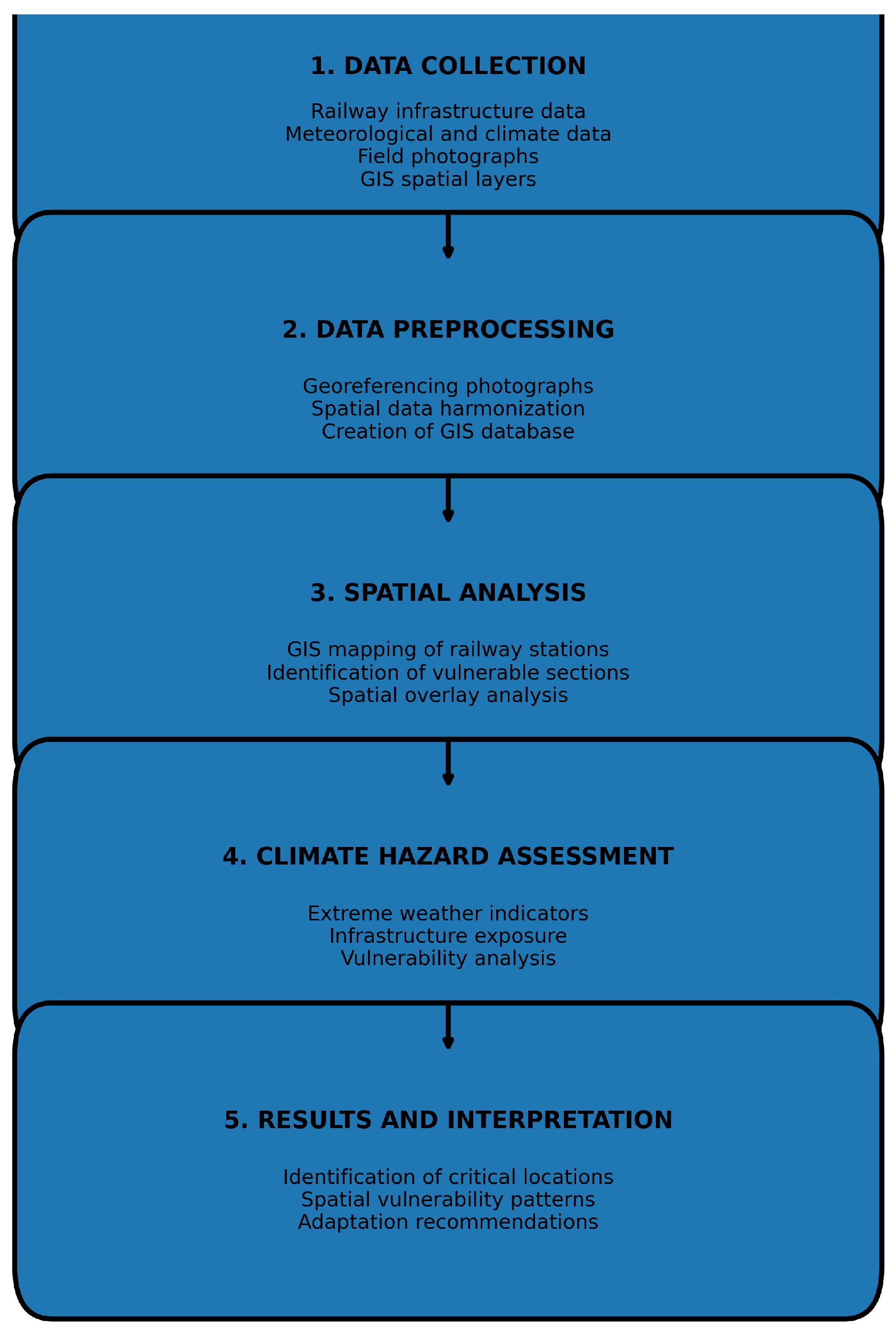
All spatial datasets were processed within a Geographic Information System (GIS) environment using the World Geodetic System 1984 (WGS84) geographic coordinate system. For spatial analyses and distance-based calculations, the data were projected into the Universal Transverse Mercator (UTM) coordinate system, Zone 34N, which is commonly used for spatial analyses in Serbia and Southeastern Europe. This projection system ensures accurate distance measurements and spatial overlay operations used in buffer analysis, kernel density estimation, and zonal statistics. Table 1 summarizes passenger flows at major railway stations in Serbia, including gender distribution and temporal travel patterns. The data indicate noticeable differences between stations, particularly between major urban centers and smaller regional stations. Larger stations such as Belgrade, New Belgrade, and Novi Sad show higher passenger volumes and a relatively larger proportion of female travelers. In contrast, smaller stations located in peripheral areas exhibit lower passenger numbers and more limited infrastructure conditions. These differences highlight the importance of evaluating railway infrastructure and safety conditions from a gender-sensitive perspective. All spatial analyses were conducted using QGIS version 3.18, an open-source Geographic Information System platform widely used for spatial data processing and mapping. Additional geostatistical and terrain-based analyses were performed using SAGA GIS (System for Automated Geoscientific Analyses). These software platforms were used to perform spatial operations including kernel density estimation, buffer analysis, spatial interpolation, zonal statistics, and map visualization (Figure 2).

Elaboration of Problem

The spatial and statistical analyses in this study were based on multiple data sources related to railway infrastructure, passenger traffic, safety incidents, and environmental conditions in Serbia. Railway infrastructure data, including railway lines and station locations, were obtained from the official database of Serbian Railways and the national railway operator Srbija Voz. Additional spatial data on railway tracks and infrastructure were extracted from OpenStreetMap (OSM) and verified using satellite imagery. Passenger traffic data were collected from railway ticketing statistics, including online ticket sales and passenger distribution by gender for selected railway stations. Safety incident data, including attacks, robberies, and train–vehicle collisions near railway infrastructure, were compiled from local police reports, municipal safety records, and publicly available transportation safety databases. Climate hazard indicators, including floods, heavy snowfall, windstorms, and extreme temperature events, were derived from national meteorological datasets and previous climate hazard studies related to Serbia. Satellite imagery from the Landsat 8 mission was used to analyze the spatial patterns of night lighting and infrastructure visibility near railway stations. All spatial datasets were processed and integrated within a Geographic Information System (GIS) environment using QGIS 3.18 and SAGA GIS software. These datasets were subsequently used to perform spatial analyses including kernel density estimation, buffer analysis, zonal statistics, and spatial interpolation.
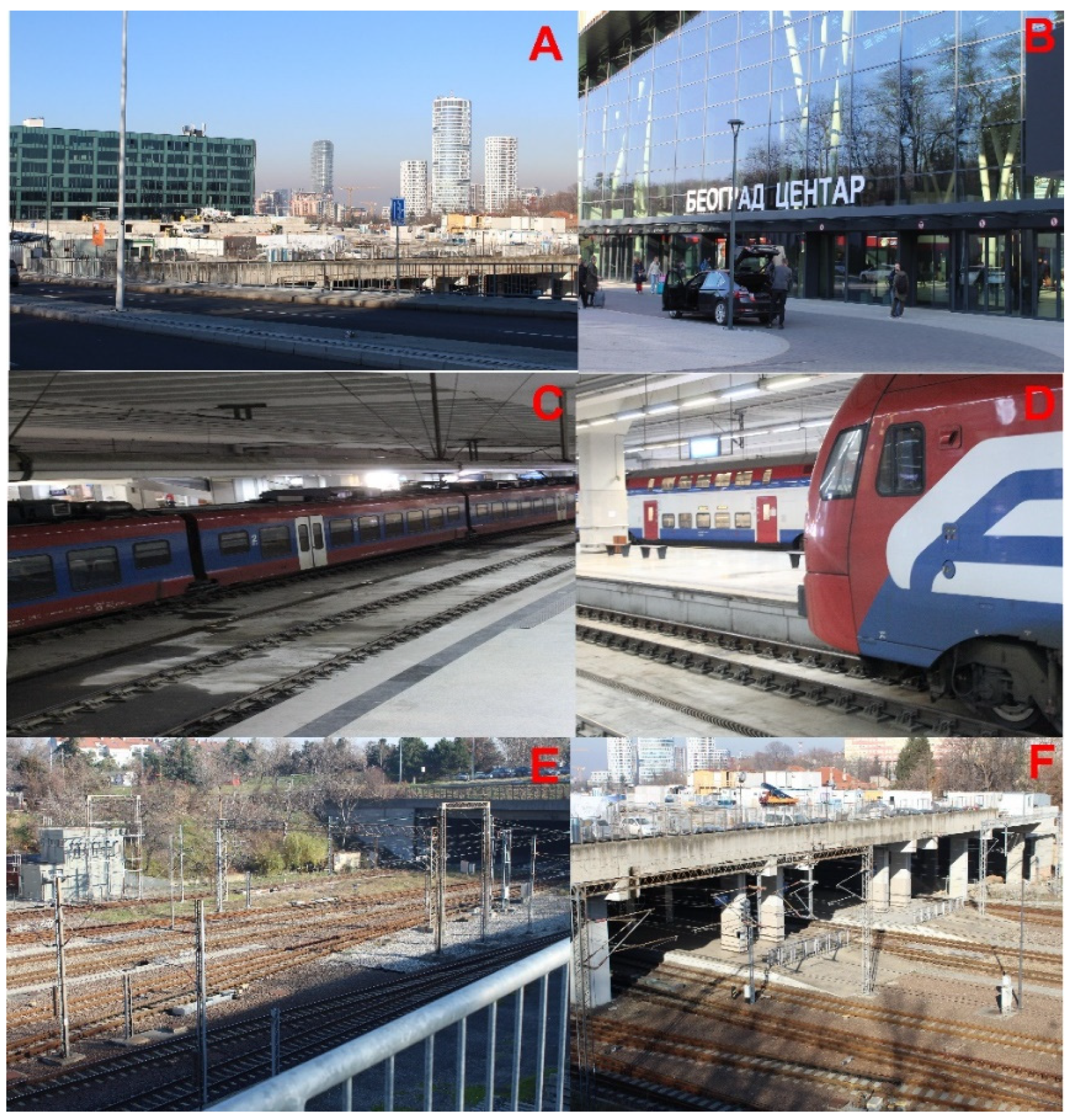
The initial examination of Table 1 revealed that the high-speed train routes exhibit a higher frequency of passenger traffic during nighttime compared to other routes, particularly along Corridor 10 (X). Women constitute the majority of passengers at the Novi Sad, Belgrade, and New Belgrade stations, all of which are serviced by high-speed trains. Additionally, both the New Belgrade and main Belgrade stations are linked to local train services throughout the day and night [37,38]. The proportion of female passengers between 2010 and 2020 was 17.73% at Belgrade Central Station, 31.62% at New Belgrade, 24.64% at Novi Sad, 26.19% at Pančevo, 20.43% at Mladenovac, 10.77% at Kusadak, and 9.55% at Smederevska Palanka. Analysis using Geographic Information Systems and remote sensing techniques indicates that passengers, particularly families, utilize the ninth train lines within the Belgrade railway network. The distance between Belgrade Central Station and Smederevska Palanka is 85.3 km, with female passengers comprising 23% of the total on the ninth lines (see Table 1). The observed percentage of female passengers at Belgrade Central Station deviates from expectations, considering its status as the primary hub for all national and international train routes, including the line to Montenegro. Despite there being 12 total lines according to the timetable, some lines exhibit lower numbers of family passengers, particularly those in the southern region or between Belgrade and Niš. In this study, an analysis was conducted on 30 train stations within Serbia’s railway system. The two largest railway stations, Belgrade and Novi Sad, situated along the high-speed route, serve as the primary transportation hubs for the country [39]. These stations are integral components of the future Pan-European corridor for high-speed trains connecting Belgrade (Serbia) and Budapest (Hungary). Over the past fifty years, the municipal government of Belgrade has endeavored to relocate the position of the train station. The original station, constructed in 1884, was situated in the central core of the city, serving as the starting point for routes between Belgrade and Niš, linking the capital with the southern regions of the country [40]. The coordinates of the former Belgrade train station are 44.809205° N and 20.455827° E. Public transportation services operating from the old station include tram lines 9, 11, and 12, as well as bus lines 51N, 83, EKO2, 36, 83, and 78 (see Figure 3). The old station features nine daytime lines and three nighttime lines. Over the past two decades, the vicinity surrounding the old train station has witnessed 312 attacks on women, particularly escalating between 2015 and 2020 due to the station’s reconstruction and subsequent conversion into a museum. Key factors contributing to these attacks include inadequate public lighting and the cessation of security services at the station after 10:00 PM. Despite these challenges, one advantage of the old train station is its superior connectivity to the city’s public transportation network compared to the new station, with convenient access to trams and buses, as well as close proximity to the main traffic hub at Slavija square, approximately 1800 m away (Figure 4).
Figure 3 presents photographs of the Belgrade railway station and its surrounding infrastructure, including the main building of the former station (A), railway platforms and passenger access areas (B), surrounding urban infrastructure and public transport connections (C), adjacent railway tracks and operational zones (D), station surroundings characterized by limited lighting and reduced visibility conditions (E), and Entrance to the depot of the main railway station (F).
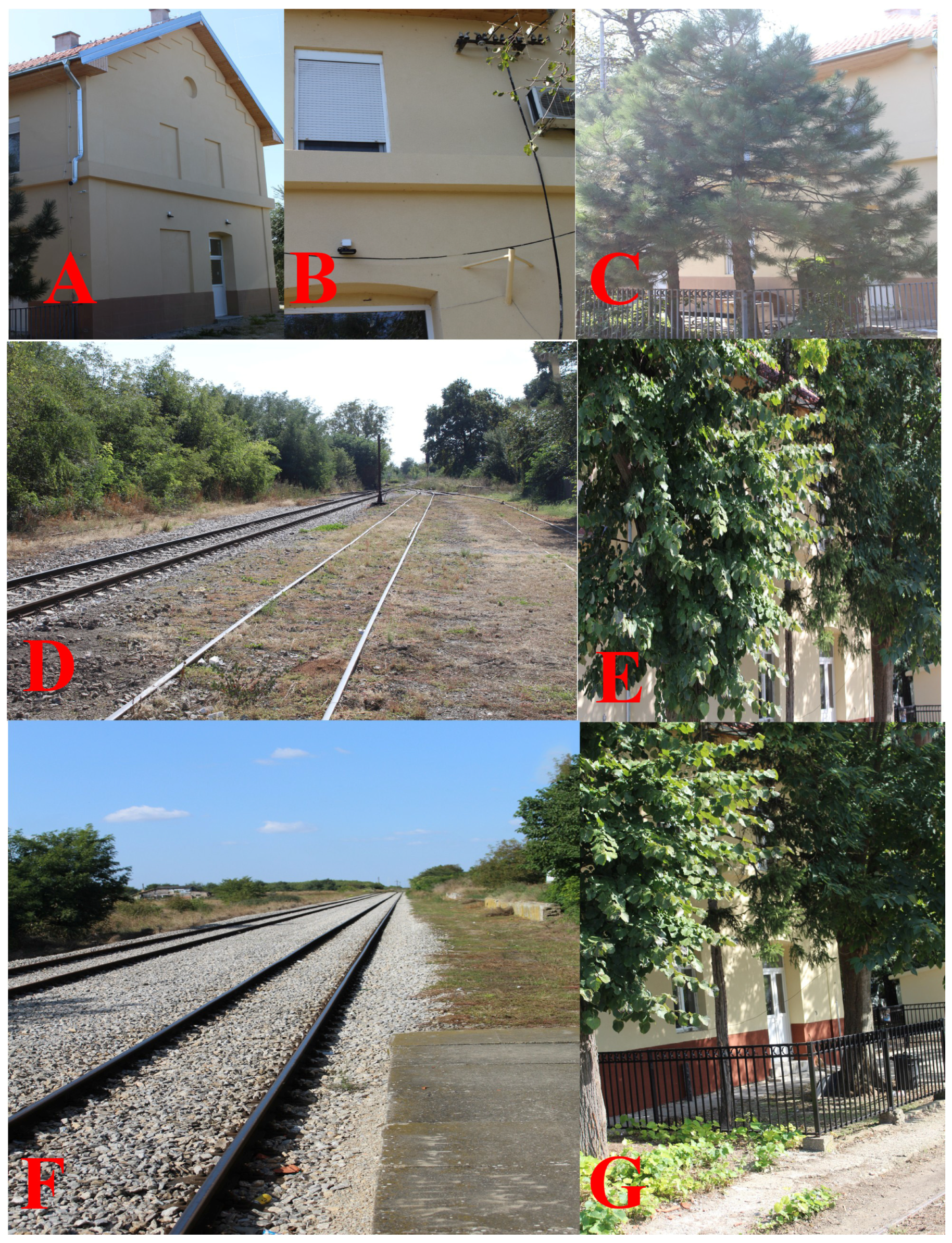
The construction of the new train station, known as Prokop or the new Belgrade train station, is currently underway (see Figure 4). Once completed, this station will feature a parking area with 500 spaces, a hotel, and 12 railway tracks [41]. However, a significant challenge lies in its geographical position (44.7936° N; 20.4539° E), which lacks optimal connectivity to public transportation vehicles. Presently, the only lines operating directly to the main train station are the 40 and 41 troll lines, along with the 34, 36, 38 L, and 600 bus lines. Unlike the old Belgrade station, the new station boasts enhanced safety measures, including improved internet and mobile connectivity, halogen lighting inside and outside the station, and an increased number of police patrols, which have resulted in a significant decrease in incidents, with only two attacks on women reported between 2020 and 2023. Furthermore, plans are in place to establish new public transportation routes between the station and various parts of the city. Additionally, there will be a minimum of 20 taxi stands, along with the construction of two police stations in the station’s vicinity and five security points both inside and outside the premises. Surveillance coverage will be extensive, with cameras installed to cover 90% of the station, with a particular focus on ensuring the safety of women and children. Despite the new station’s anticipated heavy railway traffic, expected to account for 70% of total railway traffic compared to other lines, safety measures are being implemented to ensure adequacy (Figure 3). Other train stations in Serbia collectively cover 30% of all lines. The route between Belgrade main station and Kikinda, traversing the Banat region, remains crucial. Although constructed in the 19th century, this route continues to serve as a viable alternative when the main route between Belgrade and Novi Sad is unavailable. Moreover, it serves as a vital link with Romania, making it Serbia’s only railway connection to a European Union country [42]. However, safety concerns persist for women, despite reconstruction efforts and station renovations along the Belgrade–Pančevo–Zrenjanin route. The main safety issues stem from crossings in relatively small cities and villages, exacerbated by inadequate public lighting, particularly near stations [43,44]. The analysis conducted in this study revealed a 30% increase in attacks on women near stations between 2000 and 2020. The average distance from police stations to the main train station along this route is 3.5 km (see Figure 4). Pančevo, Debaljača, Zrenjanin, and Kikinda emerge as the safest stations along this route, primarily due to their round-the-clock operation and permanent attendance (Figure 4 and Figure 5).
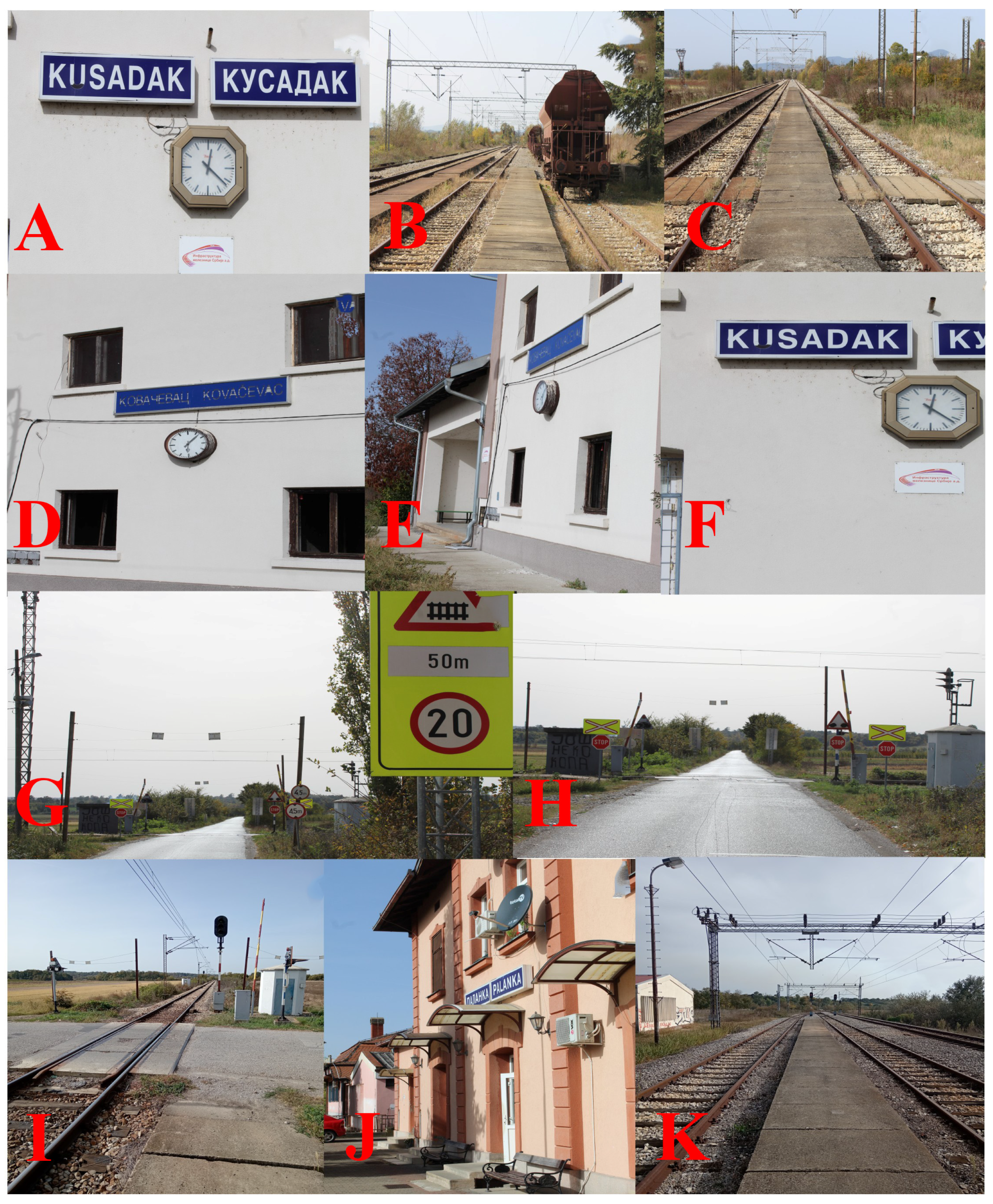
As shown in Figure 5, several locations are characterized by insufficient lighting conditions, limited surveillance systems, and inadequate access to emergency services.
The next analyzed railway route is that between Belgrade and Niš. The city of Niš is the biggest city in south Serbia and the third in the whole country. This route is planned to be renovated in the next ten years to allow for high-speed trains. Now, only four trains operate throughout the day between these cities. Thus, this route takes more than five hours. Because the average speed is 55 km/h, it is very rare for passengers to take this train between the two cities to reach their final destination. Local trains are found in the middle of the route between the stations of Mladenovac and Velika Plana. These trains increase the number of passengers by more than 20%. Safety on this important route is better in the first part of the railway. Stations in big cities such as Mladenovac, Smederevska Palanka, Velika Plana, Jagodina, Ćuprija, Paraćin, Aleksinac and Niš are safer than stations in small cities or villages. The most unsafe stations are stations without permanent railway staff. According to data from 2000 to 2020, on this route, 25% of attacks were on women. In stations in small villages, this figure is 70% greater than that in stations with permanent staff. The main reason for this lies in the very poor communication between railway stations and police stations. The average distance from police stations is greater than 10 km. Public lights are not functioning in more than 40% of stations. In the suburbs and train stations without permanent railway staff, a bigger problem is poor internet and mobile network connection. Only 10% of stations on this route have internet connection, and 85% have good mobile network connection. In recent decades, the predominant role in spatial and traffic network analysis has been assumed by remote sensing (RS) and Geographical Information System (GIS). The identified patterns are clearly visible across individual panels in Figure 5A–K, which highlight variations in infrastructure quality and safety conditions. In addition, GIS-based analysis provides a clearer understanding of the spatial clustering of vulnerable locations.
The spatial analysis indicates that these vulnerable areas are not randomly distributed but are concentrated in specific segments of the railway network. Utilizing GIS and RS analyses can expedite railway traffic processes and enhance safety and comfort. Railway traffic, whether private or public, has become increasingly prominent in recent times. In the Republic of Serbia, governmental efforts over the past few decades have aimed to render railway traffic transparent, affordable, and safe. Various GIS and RS methodologies can be applied to railway networks [45,46]. The analyses of railway properties can be refined through the application of ordinary, advanced, and remote sensing methods, with the combination of both approaches yielding satisfactory results [47]. The evaluation of women’s safety in this research utilizes two distinct approaches. The first set of methodologies focuses on numerical geostatistics, while the second involves spatial analysis. All methodologies employed in this study underwent validation using two open-source GIS software platforms: Quantum Geographical Information System (QGIS) 3.18 and SAGA—System for Automated Geoscientific Analyses 2.0 [48]. The GIS techniques utilized in this study encompassed kriging and semi-kriging to accurately determine the spatial positions of railway stations. Segmental point and line buffers were applied to delineate the locations of rural attacks on women and various railway accidents. Neighbor analysis was executed to evaluate incidents occurring between railway track positions and investigated points. Zonal statistics were utilized to determine the positions of labeled attacks on women and railway tracks. Calculating railway track intersection density played a pivotal role in assessing the combined impact of diverse factors on women’s safety. Additionally, advanced remote sensing methods, including pixel and sub-pixel analysis and supervised and unsupervised pixel classifications, were employed to analyze light properties near railway stations [49,50,51]. Utilizing statistical analysis validated by GIS is crucial for determining the density of attacks on women per 1 km2 of railway track in relation to the total number of passengers at the analyzed stations (see Equation (1)).
Q R = ( Total numner of passengers ) ( Attacks on passanger ) ( Mid-year , number of passengers ) × l n T 2
Q R is the statistical value of attacked passengers on the railway, and l n T 2 is the natural logarithm of the density of railway tracks per 1 km2. The value varies between −1 and 0 up to 100. The highest value indicates better safety per year. Data on the properties of railway tracks and the position (locations) of accidents were obtained from a digitized map. This equation was subsequently used to compare all accidents close to railways.

3. Results

3.1. Temporal Trends in Railway Safety Incidents

The temporal analysis of railway-related incidents between 2000 and 2020 reveals several important trends in the Serbian railway network. During the early period (2000–2005), safety incidents were relatively concentrated along major railway corridors and in larger municipalities such as Pančevo, Subotica, and Niš. A total of 58 cases were recorded, with approximately 80% of train operations occurring during daytime hours. Between 2005 and 2010, the railway network experienced a reduction in operational services, including route closures and decreased train frequencies. Despite these reductions, the number of recorded incidents increased to 72 cases across 16 municipalities. A notable shift during this period was the growing proportion of incidents occurring at night, particularly between 23:00 and 04:00. The period 2010–2015 marked the most significant structural change within the railway system, when more than 3000 km of railway lines and 234 stations were decommissioned. During this time, safety incidents expanded geographically, especially in eastern and southern Serbia, while approximately 65% of reported incidents occurred in the Belgrade metropolitan area. During the final period (2015–2020), the total number of incidents slightly declined. However, nighttime incidents remained dominant, accounting for approximately 81% of all recorded cases, highlighting the importance of station lighting, surveillance systems, and operational staffing for passenger safety. Overall, these results highlight the need for integrating safety-oriented planning into railway infrastructure development.

3.2. Spatial Patterns and High-Risk Zones

The spatial GIS analysis reveals clear regional disparities in railway safety conditions across Serbia. Northern regions, particularly in Vojvodina (Subotica, Sombor, and Zrenjanin), show relatively low safety risk levels due to active stations, improved infrastructure, and stronger surveillance coverage. In contrast, southern and southeastern Serbia including Leskovac, Vranje, and Dimitrovgrad represent the most vulnerable zones. These areas are characterized by inactive stations, limited lighting infrastructure, weak digital connectivity, and longer distances to emergency services. Central Serbia displays moderate risk levels, particularly in municipalities such as Jagodina, Kragujevac, and Užice, where safety infrastructure exists but remains inconsistently maintained. Despite modernization efforts, the Belgrade metropolitan area also exhibits elevated vulnerability due to high passenger volumes and the presence of older suburban stations. Overall, the analysis shows that municipalities with populations between 10,000 and 100,000 residents represent the most vulnerable spatial category, combining moderate passenger demand with insufficient safety infrastructure. The spatial distribution of railway safety risks is also influenced by climate-related hazards. Areas located in southern and eastern Serbia are more frequently exposed to extreme weather events such as heavy snowfall, floods, and strong wind episodes. These climate conditions increase infrastructure vulnerability by affecting railway tracks, signaling systems, and station accessibility. Consequently, stations located in these regions show higher vulnerability scores within the spatial analysis framework. The observed spatial disparities are closely related to differences in regional development and infrastructure conditions. Southern and southeastern Serbia are characterized by lower population density, weaker economic development, and limited institutional resources for infrastructure maintenance and security monitoring. In many municipalities, railway stations are located at greater distances from police services and often operate without permanent staff. These factors collectively contribute to higher vulnerability levels and explain why these areas consistently appear as high-risk zones in the spatial analysis.

3.3. Gender-Specific Safety Findings

The analysis also highlights important gender-related safety disparities across the railway network. The Women’s Railway Safety Index (WRSI), developed in this study, integrates infrastructure quality, accessibility, incident density, distance to emergency services, and climate exposure. The results indicate that women are particularly vulnerable in stations characterized by poor lighting conditions, limited surveillance, and weak digital connectivity. These risks are the most pronounced in rural and peripheral stations where permanent staff and security systems are absent. Approximately 60% of rural railway stations are located in medium- to high-climate-risk zones, while fewer than one-third meet the minimum safety infrastructure standards. Stations located in southern and eastern Serbia consistently show the lowest WRSI values, indicating the highest vulnerability levels. In contrast, stations along the Belgrade–Novi Sad high-speed railway corridor demonstrate significantly higher safety scores due to modern infrastructure, improved lighting, digital connectivity, and continuous station staffing. The higher vulnerability of women in certain railway environments is strongly associated with infrastructure and spatial characteristics. Stations with limited lighting infrastructure, the absence of permanent staff, and longer distances from police services show significantly lower safety index values. These spatial factors increase perceived and actual safety risks for female passengers, particularly during nighttime travel when the majority of incidents occur.

3.4. Implications for Railway Safety and Resilience

The results emphasize several important implications for railway planning and policy development. First, the strong regional disparities highlight the need for targeted investments in railway infrastructure, particularly in southern and eastern Serbia. Second, improving gender-sensitive safety infrastructure including lighting systems, surveillance technologies, and emergency accessibility could significantly reduce safety risks for women and other vulnerable passenger groups. Finally, the spatial overlap between railway infrastructure and climate hazard zones suggests that railway modernization strategies should integrate climate resilience measures, including improved weather monitoring systems and infrastructure adaptation. Overall, the GIS-based analytical framework developed in this study provides a practical decision-support tool for identifying high-risk zones and prioritizing safety interventions within Serbia’s railway system. Infrastructure aging also plays an important role, as many railway stations in peripheral regions have not undergone major modernization for several decades, resulting in outdated lighting systems, limited surveillance, and reduced operational capacity.
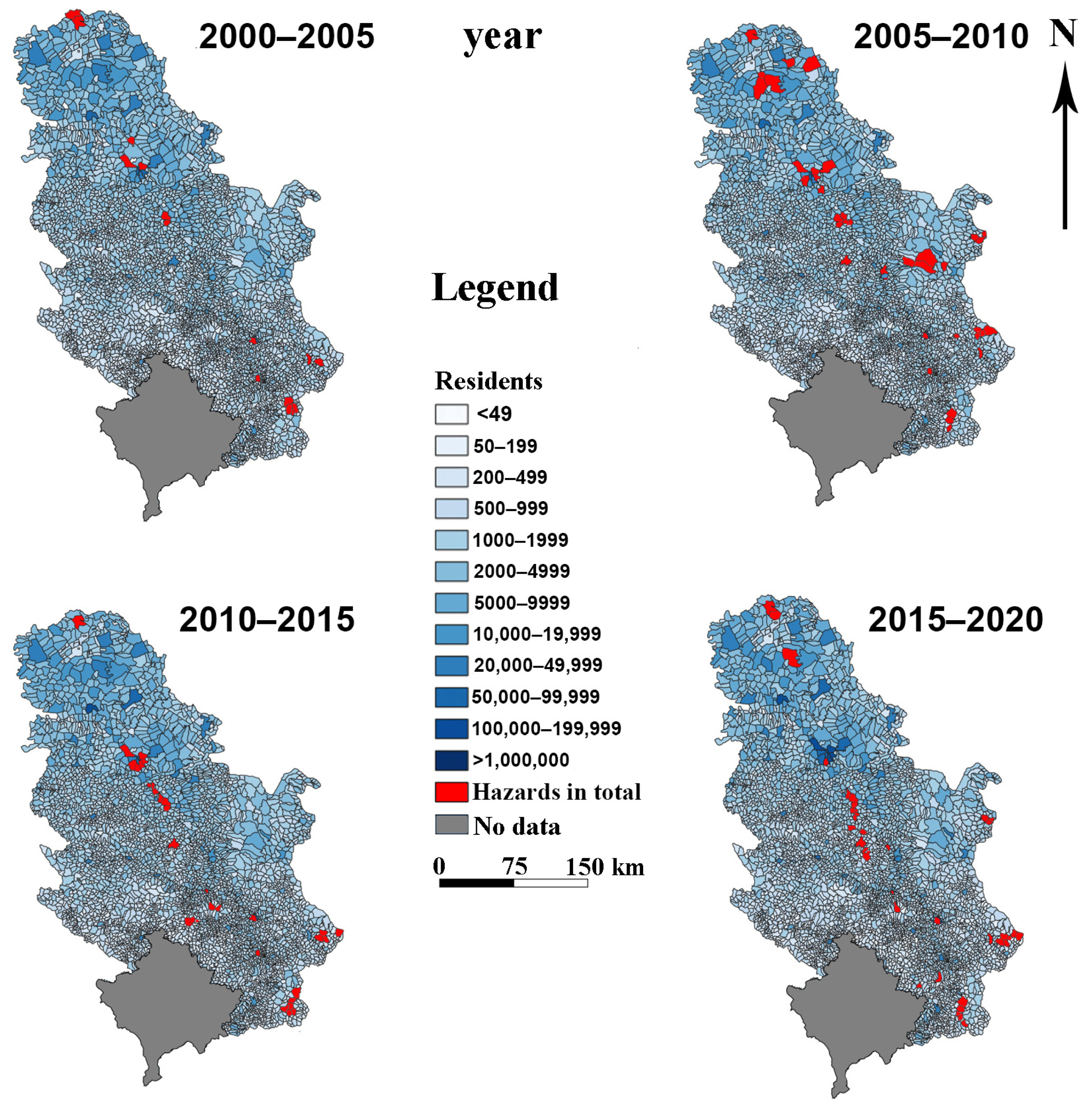
Figure 6 illustrates the spatial distribution of railway-related hazards across Serbia over four consecutive five-year periods (2000–2020), with municipalities represented according to population size and hazard occurrences marked in red. The maps reveal a clear temporal escalation in reported hazards, starting with localized incidents primarily in northern and southeastern Serbia during 2000–2005, particularly in municipalities such as Pančevo, Subotica, and Niš. The period 2005–2010 shows a geographic expansion of hazards toward central and western Serbia, including municipalities like Lapovo and Valjevo. The most significant increase occurred during 2010–2015, coinciding with the closure of over 3000 km of railway lines and 234 stations. Hazards during this period were widely distributed across eastern, southern, and western Serbia, indicating declining infrastructure quality and reduced monitoring in decommissioned areas. Although the number of affected municipalities slightly declined during 2015–2020, recurrent incidents continued in key nodes such as Subotica, Niš, and Vranje. Notably, most hazards occurred in municipalities with populations between 10,000 and 100,000, suggesting that mid-sized urban zones and transitional areas remain particularly vulnerable. This spatiotemporal trend highlights the correlation between network reduction and increased safety risks, particularly in areas with limited surveillance, poor lighting, and reduced train frequency. The visual analysis supports the need for targeted safety interventions in consistently affected municipalities and recommends integrating crash and injury indices with GIS to better inform future railway safety planning. The total proportion of railway-related incidents involving passengers during the 2015–2020 period accounted for 75%, with the majority occurring in the late-night hours between 1:00 a.m. and 5:00 a.m. This period marks a notable shift from previous intervals (2000–2005, 2005–2010, and 2010–2015), largely due to the construction of the new high-speed railway line connecting Serbia and Hungary (Belgrade–Budapest). The need for enhanced security measures near newly developed railway stations contributed to this change. A total of 46 cases were recorded across 13 municipalities, primarily taking place between 11:00 p.m. and 4:00 a.m., reflecting a 19% decrease compared to the 2010–2015 period. Unlike earlier phases, where incidents were concentrated in urban and suburban areas, the 2015–2020 period saw the emergence of new cases in municipalities such as Leskovac and Vranje, located along Corridor X (Belgrade–Niš–Leskovac–Vranje–Bitola–Skopje–Thessaloniki–Athens), which connects Serbia with North Macedonia and Greece. This overall decline in reported incidents may partly be attributed to the suspension of nearly all international train services. Meanwhile, the Novi Sad–Vrbas–Bačka Topola–Subotica line is undergoing upgrades to accommodate high-speed trains. Other ongoing reconstruction efforts include the Belgrade–Pančevo–Vršac–Stamora Moravita–Timișoara line, the Belgrade–Niš–Skopje–Bitola–Thessaloniki–Athens corridor, and the Niš–Pirot–Dimitrovgrad–Sofia line. In contrast, the Belgrade–Tovarnik–Zagreb–Ljubljana route remains non-operational for passenger traffic. Throughout the analyzed period, 81% of all reported cases occurred on night train services (see Figure 6 and Figure 7) [52,53,54].
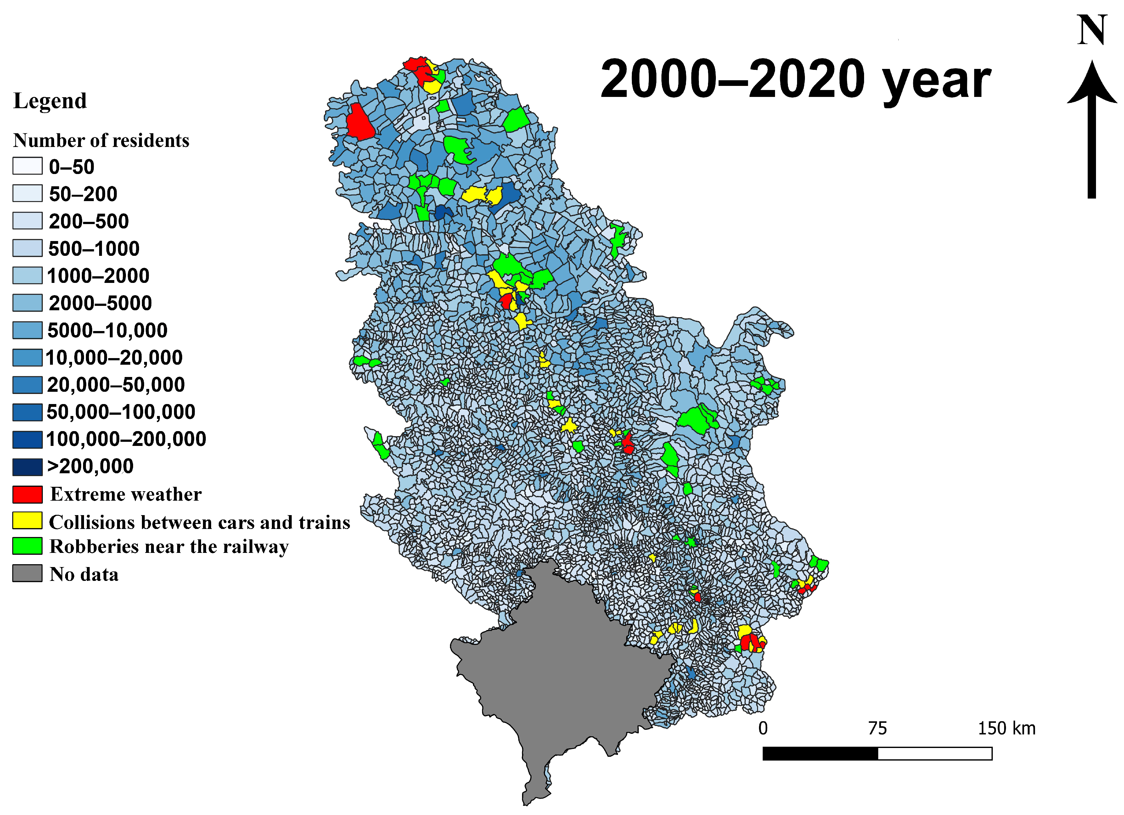
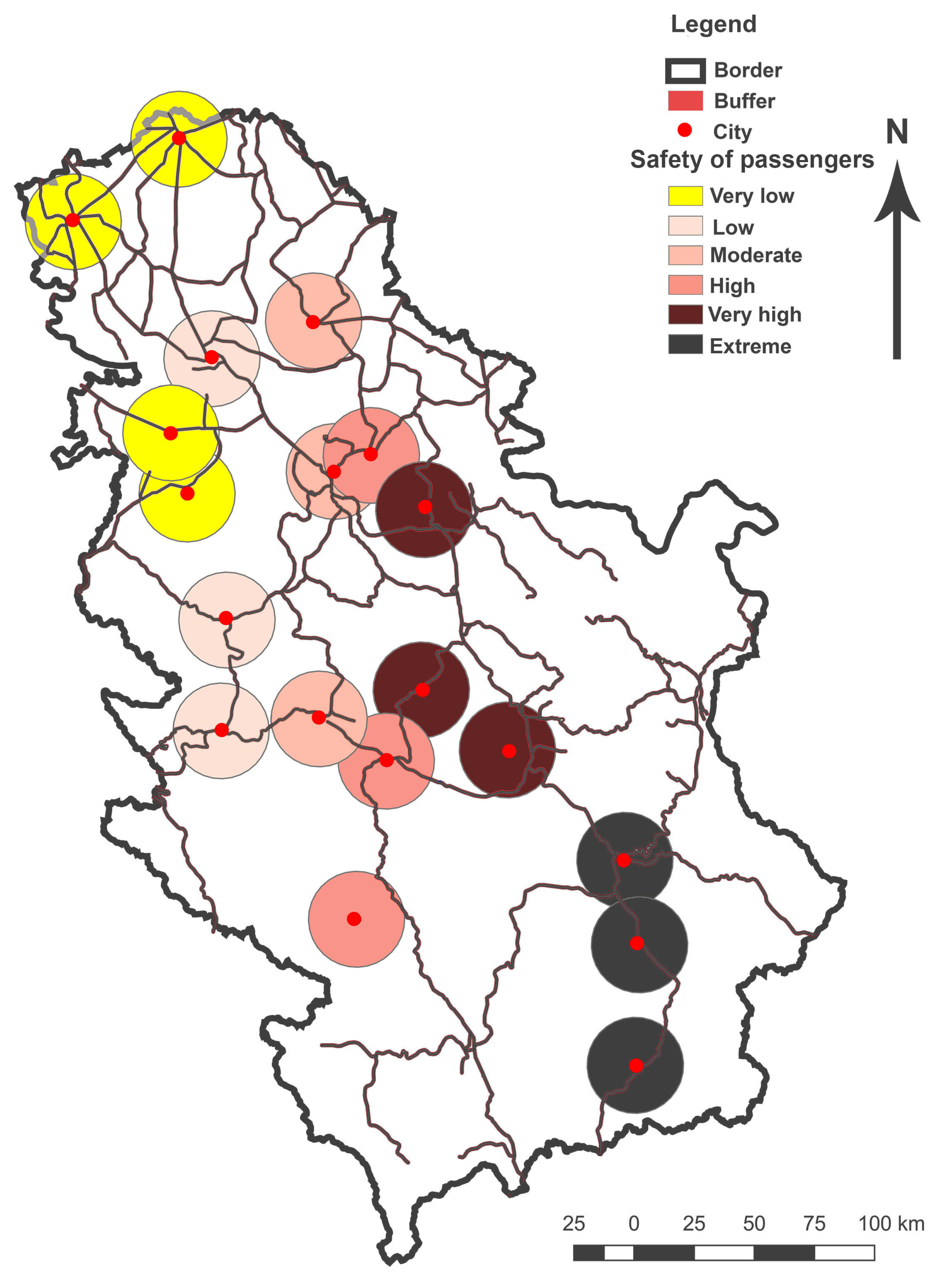
Figure 6 presents a spatial analysis of three key categories of railway-related hazards in Serbia over the two-decade period from 2000 to 2020: extreme weather events (red), collisions between cars and trains (yellow), and robberies near the railway (green). These events are mapped at the municipal level and displayed against a background layer representing population density, ranging from sparsely populated rural areas (<50 residents) to highly urbanized municipalities (>200,000 residents). The map reveals several important spatial patterns. Extreme weather-related disruptions are particularly concentrated in northern and southeastern Serbia, with notable clusters in Subotica, Vranje, and surrounding areas. Collisions between vehicles and trains appear the most frequently in central Serbia, forming a linear pattern that reflects the alignment of major railway corridors, particularly the Belgrade–Niš axis. Robberies near railway infrastructure are distributed more broadly but are especially concentrated in the northwestern and eastern regions, with higher occurrences in municipalities like Zrenjanin and Senta and parts of the Timok Valley. Interestingly, many incidents, especially collisions, occur in mid-sized municipalities (2000–50,000 residents), indicating vulnerability along secondary rail lines and road crossings with inadequate protection. Southern Serbia also exhibits a concentration of multiple hazard types, likely linked to weaker infrastructure and lower surveillance coverage. Overall, this map underscores the need for differentiated safety strategies depending on hazard type, with particular attention to high-risk corridors, road–rail intersections, and municipalities with recurring multi-hazard profiles. The findings derived from spatial analyses and recorded data sourced from local communities and Serbian railways have yielded intriguing and insightful results. This study analyzed three distinct types of incidents: attacks on women, collisions involving cars and trains, and robberies near railway premises. The data were scrutinized through linear regression and spatial representation methods. According to data spanning the period from 2000 to 2020, robberies emerged as the most frequent type of incident occurring in the vicinity of railway stations and tracks, followed by collisions between cars and trains and attacks on passengers. In the initial period (2000–2005), the majority of attacks targeted passengers in northern Serbia and select municipalities within Belgrade. During the 2010–2015 period, a noticeable increase in incidents was recorded in southern Serbia. In contrast, collisions between trains and vehicles remained relatively stable across all four timeframes (2000–2005, 2005–2010, 2010–2015, and 2015–2020), with most events occurring near disused or poorly maintained railway crossings. Approximately 80% of traffic-related robberies occurred along non-electrified railway lines, particularly concentrated in southern and eastern Serbia, often near abandoned stations and areas with insufficient public lighting. Temporal analysis revealed that attacks on passengers were the most frequently reported between 1:00 a.m. and 4:00 a.m., collisions between trains and vehicles occurred primarily between 11:00 p.m. and 2:00 a.m., and robberies peaked between 3:00 a.m. and 6:00 a.m. The analysis also included the median yearly incident rates and a spatial assessment of municipalities. The average area of municipalities where robberies were reported was approximately 500 km2, with a median area of 275 km2. Buffer-based categorization showed that the majority of incidents across all three types occurred in municipalities ranging from 250 km2 to 500 km2, accounting for 65% of total cases. Municipalities ranging from 0 to 250 km2 accounted for 20%, while those spanning 500–1000 km2 represented 10%. Only 5% of incidents occurred in municipalities exceeding 1000 km2 in area. This spatial distribution is attributed to the fact that larger municipalities, especially those under the jurisdiction of urban centers, generally possess more developed law enforcement infrastructure. The analysis of passenger safety using GIS and statistical methods further revealed that municipalities in the 250–500 km2 range recorded the highest number of incidents over the two-decade period. This trend is strongly associated with their proximity to major railway corridors, particularly in southern and northern Serbia, where approximately 70% of lines remain non-electrified. Approximately 80% of incidents involving assaults on women were examined and evaluated using data spanning the period from 2000 to 2020. The locations of train stations were determined using GPS receivers, and spatial data from OpenStreetMap (OSM) were retrieved through the OSM algorithm. Additionally, active train lines were extracted from the official database of Serbian Railways (https://w3.srbvoz.rs/redvoznje, accessed on 25 March 2023). Further spatial analyses included hub distance and hub line assessments, which were effective in estimating collision risks between trains and vehicles. Satellite imagery was also employed, specifically nighttime detection, to visualize Serbia’s railway network and assess station visibility and lighting conditions. A night light map was produced to illustrate the safety status of train stations across the country. Two types of buffer zones were applied in map creation. The first, line buffers, delineated the spatial extent of assaults on women along railway lines over the past two decades, covering approximately 70% of the main corridors. The second, circular buffers, represented a broader range of railway-related incidents including robberies, assaults, extreme weather events, and traffic accidents and were sized proportionally based on geographical projections. The buffer and zonal statistical analyses conducted in this study identified five railway safety zones associated with varying distances from the tracks. These zones included a core 200 m radius, followed by bands of 200–300 m, 300–500 m, 500–600 m, and areas beyond 600 m. The circular buffer analysis revealed the 20 most hazardous train stations for women’s safety in Serbia (see Figure 7). To improve the precision of station location data, high-resolution satellite images from the Landsat 8 mission (2020) were incorporated. With a spatial resolution of 30 m, these satellite datasets were integrated with other spatial layers for a comprehensive geostatistical analysis [55,56].

3.5. Specific GIS and Spatial Analyses of the Safety and Position of Railway Stations

Figure 7 presents a spatial buffer map analyzing passenger safety across Serbia’s railway network from 2000 to 2020. The color-coded classification ranging from very low risk (yellow) to extreme risk (black) highlights significant regional disparities. Northern areas such as Subotica, Sombor, and Zrenjanin show very low safety risks, likely due to active station operations, better infrastructure, and higher surveillance coverage. In contrast, southern and southeastern municipalities including Leskovac, Vranje, and Dimitrovgrad fall within extreme-risk zones, reflecting a combination of inactive stations, poor lighting, limited internet/mobile connectivity, and long distances to police services. Central Serbia exhibits moderate- to high-risk zones, including cities like Jagodina, Kragujevac, and Užice, where some security measures are in place but inconsistently maintained. The Belgrade metropolitan area, despite its modern central station, also shows very high risk, likely a result of dense passenger traffic, urban sprawl, and a number of older, poorly secured suburban stations. These patterns underscore the urgent need to improve infrastructure, lighting, surveillance, and emergency accessibility, particularly in high- and extreme-risk zones. The buffer zones offer a useful tool for spatially prioritizing interventions aimed at enhancing passenger safety across the Serbian railway network [57].
The safety assessment of railway stations in this study was based on several infrastructure, spatial, and operational indicators. The main safety aspects considered include lighting conditions around stations and platforms, the presence of surveillance and security systems, distance to police and emergency services, passenger traffic volume and gender distribution, connectivity to public transportation networks, the availability of internet and mobile communication coverage, and exposure to climate-related hazards such as floods, heavy snowfall, heatwaves, and strong winds. These indicators were integrated within the GIS framework to evaluate spatial safety patterns and identify railway stations with higher levels of vulnerability (Figure 8).
The outcomes derived from the spatial methodology employed in this study were validated using Equation (1) within a GIS-based analytical framework. The analysis covered data from the period 2000 to 2020. A vector map of Serbia’s railway infrastructure was created, incorporating all train stations as point features. Approximately 60% of railway tracks and 70% of the total number of railway lines were included in the analysis. For the purpose of regional assessment, the railway network was divided into six distinct geographic zones (Table 2) [58,59]. Improving lighting conditions, surveillance systems, and wayfinding infrastructure represents a key safety measure for railway stations. However, previous studies have shown that such improvements provide particularly significant benefits for vulnerable passenger groups, especially women, who often report higher levels of perceived insecurity in poorly lit and inadequately monitored transport environments. Therefore, enhancing these infrastructure elements can contribute not only to overall passenger safety but also to reducing gender-related mobility barriers within railway systems.
The findings presented in Table 2 summarize the comprehensive spatial analyses conducted on Serbia’s railway network. The results highlight distinct safety challenges for passengers, with the highest risks observed in southern Serbia, particularly affecting individuals residing in or traveling through that region. The analysis also reveals a concentration of train vehicle collisions in central Serbia, while robberies and other illegal activities are more prevalent in eastern Serbia. The severity index reaches its peak in the Belgrade region, which also exhibits the highest rate of network connectivity, followed by central and southern Serbia. Interestingly, despite its economic disadvantages, southern Serbia, along with the Belgrade region and the province of Vojvodina, has one of the densest railway networks in the country. Although notable improvements in railway security have been recorded over the past decade, especially in Belgrade, challenges persist. The completion of the new central railway station in Belgrade is expected to further improve safety standards, particularly for at-risk groups. The findings of this study underscore the urgent need for a cohesive national safety strategy, with a strong emphasis on protecting vulnerable rail users, including women. In this context, all municipalities located near railway infrastructure must take proactive roles in implementing preventative measures to reduce violence and improve security around train stations and railway corridors. Since the introduction of Serbia’s first private railway operator in 2016, the railway landscape has expanded to include ten domestic and three foreign companies. In 2018, the Government of the Republic of Serbia, in collaboration with the Ministry of Traffic, formally prioritized passenger safety on the national railway system. Some private cargo and passenger operators have since introduced specific safety protocols aimed at improving protection, including measures targeting women’s safety. These initiatives have extended to public awareness campaigns, such as road signage, informational websites, and television broadcasts. Despite these positive developments, efforts by local authorities, the national government, and the Ministry of Traffic remain insufficient to guarantee comprehensive safety for female passengers. There is a clear need for stricter regulation, particularly at the municipal and community levels. Educational programs should be implemented in settlements located near non-electrified railways and decommissioned stations, where infrastructure and surveillance are limited. This need is further reinforced by the recorded 4% increase in attacks against women since 2019. The deployment of interactive GIS platforms, mobile safety applications, and amber alert systems offers significant potential to strengthen safety measures. While the high-speed railway between Belgrade and Novi Sad has emerged as a model of modern infrastructure equipped with reliable internet connectivity and remote security systems, these standards must be expanded to stations outside Belgrade and central Serbia. Addressing the persistent safety concerns in southern and eastern Serbia will require sustained, coordinated action and targeted strategic interventions [60,61].

4. Discussion

4.1. Regional Disparities

The results reveal clear regional disparities in railway safety conditions across Serbia. Northern regions, particularly the province of Vojvodina, demonstrate lower safety risks due to better infrastructure conditions, active station operations, and stronger surveillance systems. In contrast, southern and southeastern Serbia exhibit significantly higher vulnerability levels, largely due to inactive stations, inadequate lighting, limited digital connectivity, and greater distances from emergency services. These spatial inequalities are closely associated with uneven infrastructure investment and differences in regional development. Municipalities with medium population sizes often combine moderate passenger flows with insufficient institutional capacity to maintain modern railway safety standards. Similar spatial disparities in railway infrastructure and safety conditions have also been observed in other countries, emphasizing the importance of coordinated infrastructure planning and spatial monitoring systems [30,62]. Furthermore, the reduction in or closure of railway lines in certain areas may unintentionally increase safety risks by reducing surveillance and maintenance activities. Consequently, addressing regional inequalities in railway infrastructure represents a critical component of long-term transport planning. The findings of this study are consistent with previous research highlighting spatial inequalities in transportation infrastructure and safety conditions. However, the GIS-based analysis presented here provides additional insight by identifying specific municipalities where infrastructure limitations, reduced surveillance, and exposure to climate hazards jointly increase passenger vulnerability. In the Serbian context, these factors appear particularly pronounced in the southern and eastern regions, where railway modernization has progressed more slowly.

4.2. Gendered Safety Concerns

This study highlights important gender-related safety challenges within the Serbian railway network. The results indicate that women face higher levels of vulnerability in railway environments characterized by poor lighting, limited security presence, and weak digital connectivity. Previous studies have demonstrated that mobility patterns and safety perceptions differ significantly between genders, particularly in public transportation environments [1,2,3,4]. Women often experience higher levels of perceived insecurity, especially during nighttime travel or in poorly monitored spaces. The findings of this study confirm these patterns in the context of Serbia’s railway system. The Women’s Railway Safety Index developed in this research provides a spatially explicit tool for identifying areas where gender-related safety risks are the most pronounced. Stations located in southern and eastern Serbia consistently show lower index values, indicating greater safety challenges. These results underscore the importance of integrating gender-sensitive design principles into railway infrastructure planning, including improved lighting systems, enhanced surveillance, and increased accessibility to emergency services. The findings are consistent with previous research highlighting the critical role of safety perception and infrastructure design in shaping women’s mobility patterns in public transportation systems. Moreover, the results demonstrate that gender-related safety risks are not only socially constructed but also spatially structured, particularly in areas where railway stations lack adequate lighting, surveillance, and digital connectivity. The spatial patterns identified in Serbia further confirm that infrastructure conditions play a decisive role in shaping gendered safety experiences.

4.3. Implications for Sustainable Transport Policy

The findings of this study have important implications for sustainable transport policy. Railway systems represent one of the most environmentally efficient modes of transportation, yet their sustainability depends not only on energy efficiency but also on infrastructure safety and accessibility. While recent modernization projects, such as the Belgrade–Novi Sad high-speed railway corridor, demonstrate the benefits of infrastructure investment, similar improvements remain necessary across secondary and regional railway networks. The integration of Geographic Information System (GIS) into railway planning offers significant advantages. GIS-based monitoring enables policymakers to identify high-risk zones, evaluate infrastructure conditions, and prioritize targeted safety interventions. In addition, climate-related hazards such as floods, heatwaves, and heavy snowfall increasingly affect railway infrastructure performance. Future transport strategies should therefore incorporate climate resilience measures in order to improve long-term infrastructure reliability and passenger safety [63,64,65,66,67,68,69]. The results of this research also align with recent studies highlighting the growing impact of climate-related hazards on transportation infrastructure. In Serbia, the spatial overlap between railway corridors and areas exposed to floods, extreme temperatures, and heavy snowfall suggests that climate resilience must become an integral part of railway modernization strategies. The GIS-based framework developed in this study provides a useful tool for identifying infrastructure segments where climate risks and passenger safety concerns intersect.

4.4. Recommendations

Based on the results of this study, several strategic recommendations can be proposed to improve railway safety in Serbia. First, a centralized GIS-based monitoring system should be developed to enable the real-time tracking of railway safety incidents and infrastructure conditions. Second, investments should prioritize improvements in lighting systems, surveillance technologies, and emergency accessibility, particularly at rural and peripheral railway stations. Third, stronger cooperation between national railway authorities, local governments, and law enforcement institutions is necessary in order to ensure consistent safety standards across the railway network. Finally, public awareness programs and educational initiatives should be implemented in communities located near railway corridors to promote safer behavior and improve the understanding of railway-related risks. Together, these measures can contribute to the development of a safer, more inclusive, and more resilient railway transport system in Serbia. Overall, the integration of spatial analysis, climate risk indicators, and gender-sensitive safety evaluation contributes to a more comprehensive understanding of railway vulnerability and provides a framework for evidence-based infrastructure planning.

5. Conclusions

The spatial analysis further indicates that railway stations located in medium-sized municipalities and rural areas represent particularly vulnerable environments. Many of these stations operate without permanent staff, adequate lighting, or modern security systems, which increases safety risks for passengers. Climate-related hazards, including floods, heavy snowfall, and extreme temperatures, also play an important role in shaping infrastructure vulnerability and operational reliability within the railway network. An important contribution of this research is the development of the Women’s Railway Safety Index (WRSI), which provides a spatially explicit tool for identifying railway environments where women face higher safety risks. The results show that stations characterized by poor lighting, weak surveillance, and limited digital connectivity tend to demonstrate significantly lower safety index values, particularly in rural and peripheral regions. These findings confirm that gender-related safety challenges are not only socially determined but also strongly influenced by spatial infrastructure conditions.
This study also highlights the importance of integrating GIS-based monitoring systems into railway planning and infrastructure management. GIS tools enable the identification of high-risk zones, support targeted safety interventions, and improve decision-making processes related to infrastructure modernization and climate resilience. Strengthening lighting systems, expanding surveillance technologies, improving digital connectivity, and enhancing emergency accessibility represent key priorities for improving railway safety conditions across Serbia. Overall, the findings emphasize the need for a comprehensive national railway safety strategy that combines infrastructure modernization, gender-sensitive transport planning, and climate-resilient infrastructure development. By integrating spatial analysis, climate hazard assessment, and gender-related safety indicators, this research contributes to the development of safer, more inclusive, and sustainable railway systems in Serbia and provides a methodological framework that can be applied in other regions facing similar infrastructure and safety challenges.

Limitations and Future Research

This study has several limitations that should be acknowledged. First, the availability and completeness of safety-related datasets remain limited, as many railway safety records and police reports in Serbia are not fully digitized or systematically integrated into a unified database. Second, the analysis relies primarily on spatial and statistical indicators derived from available infrastructure and incident data, which may not fully capture passengers’ subjective perceptions of safety, particularly among women. Third, some smaller railway stations and rural areas lack consistent long-term datasets, which may influence the spatial accuracy of the results. Future research should focus on the development of comprehensive national databases that integrate railway safety records, police reports, and passenger mobility data within a unified GIS framework. In addition, incorporating survey-based data on passenger perceptions of safety, especially among women and other vulnerable groups, could provide deeper insights into gender-sensitive mobility patterns. Further studies could also explore the integration of real-time monitoring systems, mobile safety applications, and advanced spatial modeling techniques to improve railway safety assessment and infrastructure planning.

Author Contributions

Conceptualization, Aleksandar Valjarević; methodology, Aleksandar Valjarević; software, Aleksandar Valjarević and Milan Luković; validation, Aleksandar Valjarević, Milan Luković and Dragana Radivojević; formal analysis, Aleksandar Valjarević; investigation, Aleksandar Valjarević; resources, Aleksandar Valjarević, Kh Md Nahiduzzaman, Hassan Radoine, Dejan Filipović and Dragana Valjarević; data curation, Aleksandar Valjarević and Milan Luković; writing—original draft preparation, Aleksandar Valjarević; writing—review and editing, Aleksandar Valjarević, Kh Md Nahiduzzaman, Tiziana Campisi, Celestina Fazia, Dejan Filipović and Dragana Valjarević; visualization, Aleksandar Valjarević and Dragana Radivojević; supervision, Aleksandar Valjarević; project administration, Aleksandar Valjarević; funding acquisition, Aleksandar Valjarević. All authors have read and agreed to the published version of the manuscript.

Funding

The study was supported by the Ministry of Education, Science and Technological Development of the Republic of Serbia (Contract number 451-03-34/2026-03/200091).

Data Availability Statement

The data used in the analysis and presented in this paper are available in the public repositories cited in the text. Further inquiries can be directed to the corresponding author.

Acknowledgments

The authors would like to express their sincere gratitude to the public enterprise Železnice Srbije for providing access to selected public data that were of great importance for conducting this research. Their support and data availability significantly contributed to the quality and reliability of the study.

Conflicts of Interest

The authors declare no conflict of interest.

References

  1. Campisi, T.; Georgiadis, G.; Basbas, S. Developing cities for citizens: Supporting gender equity for successful and sustainable urban mobility. In Proceedings of the Computational Science and Its Applications—ICCSA 2022 Workshops, Malaga, Spain, 4–7 July 2022; Springer: Cham, Switzerland, 2022; pp. 410–422. [Google Scholar] [CrossRef] [Scilit]
  2. Nahiduzzaman, K.M.; Campisi, T.; Shotorbani, A.M.; Assi, K.; Hewage, K.; Sadiq, R. Influence of socio-cultural attributes on stigmatizing public transport in Saudi Arabia. Sustainability 2021, 13, 12075. [Google Scholar] [CrossRef] [Scilit]
  3. Al-Rashid, M.; Nahiduzzaman, K.M.; Ahmed, S.; Campisi, T.; Akgün, N. Gender-responsive public transportation in the Dammam Metropolitan Region. Sustainability 2020, 12, 9068. [Google Scholar] [CrossRef] [Scilit]
  4. Fazia, C.; Campisi, T.; Bellamacina, D.; Catania, G.F.G. Urban and social policies: Gender gap for borderless cities. In Proceedings of the Computational Science and Its Applications—ICCSA 2023 Workshops, Athens, Greece, 3–6 July 2023; Springer: Cham, Switzerland, 2023; pp. 133–146. [Google Scholar] [CrossRef] [Scilit]
  5. Nandan, S. Determinants of customer satisfaction on service quality: A study of railway platforms in India. J. Public Transp. 2010, 13, 97–113. [Google Scholar] [CrossRef] [Scilit]
  6. Lopez-Pita, A.; Robusté, F. Modernization of railway routes. J. Public Transp. 2001, 4, 45–58. [Google Scholar] [CrossRef] [Scilit]
  7. Popović, M. Siromaština Našeg Grada Beograda; BON: Belgrade, Serbia, 1939. [Google Scholar]
  8. Milenković, M. Železničari Srbije 1918–1920; ŽTP Beograd: Belgrade, Serbia, 1971. [Google Scholar]
  9. Miletić, M. Obrenovac i Okolina; Narodna Knjiga: Belgrade, Serbia, 1963. [Google Scholar]
  10. Maksimović, B. Idejni Razvoj Srpskog Urbanizma; SANU: Belgrade, Serbia, 1978. [Google Scholar]
  11. Vasilevska, L.J.; Vranić, P.; Marinković, A. Post-socialist urban planning effects. Cities 2014, 36, 83–92. [Google Scholar] [CrossRef] [Scilit]
  12. Valjarević, A.; Živković, D.; Božović, R.; Tomanović, D.; Krsmanović, S.; Cvetković, V. Landscape changes through history following the example of the former narrow-gauge railroad Belgrade (Čukarica–Obrenovac), Serbia. J. Urban Hist. 2019, 47, 794–811. [Google Scholar] [CrossRef] [Scilit]
  13. Gulyás, A.; Kovács, Á. Accessibility changes of Budapest–Belgrade railway. In Proceedings of the 7th Transport Research Arena TRA, Vienna, Austria, 16–19 April 2018. [Google Scholar]
  14. Nikolić, I.; Arsovski, S.; Erić, M.; Vujičić, S.; Manojlović, G.; Jovanović, J. Railway infrastructure effectiveness. Teh. Vjesn. 2016, 23, 547–554. [Google Scholar]
  15. Ľupták, V.; Stopkova, M.; Jurkovič, M. Proposed methodology for the calculation of overview distances at level crossings and the inclusion thereof in national standards. Sustainability 2020, 12, 5684. [Google Scholar] [CrossRef] [Scilit]
  16. Stanisavljević, N.; Stojanović, D.; Petrović, L. Open innovation in Serbian railways. E-Bus. Technol. 2022, 2, 36–41. [Google Scholar]
  17. Mijalković, S. Recording violent crime in Serbia. Temida 2012, 15, 23–47. [Google Scholar] [CrossRef] [Scilit]
  18. Bugarski, T. Serbia: Criminal Law of the Republic of Serbia. In Criminal Legal Studies: European Challenges and Central European Responses in the Criminal Science of the 21st Century; Central European Academic Publishing: Budapest, Hungary, 2022; pp. 157–204. [Google Scholar]
  19. Simić, O. Rape, silence and denial. In Transitional Justice and Reconciliation; Routledge: London, UK, 2015. [Google Scholar]
  20. Jakšić, D. Rehabilitation in criminal law. NBP Nauka Bezb. Polic. 2014, 2, 187–196. [Google Scholar]
  21. You, J.; Nedović-Budić, Z.; Kim, T.J. A GIS-based traffic analysis zone design technique. Transp. Plan. Technol. 1998, 21, 45–68. [Google Scholar] [CrossRef] [Scilit]
  22. Wang, X. Integrating GIS, simulation models, and visualization in traffic impact analysis. Comput. Environ. Urban Syst. 2005, 29, 471–496. [Google Scholar] [CrossRef] [Scilit]
  23. Gundogdu, I.B. Applying linear analysis methods to GIS-supported procedures for preventing traffic accidents: Case study of Konya. Saf. Sci. 2010, 48, 763–769. [Google Scholar] [CrossRef] [Scilit]
  24. Shafabakhsh, G.A.; Famili, A.; Bahadori, M.S. GIS-based spatial analysis of urban traffic accidents: Case study in Mashhad, Iran. J. Traffic Transp. Eng. 2017, 4, 290–299. [Google Scholar] [CrossRef] [Scilit]
  25. Rebolj, D.; Sturm, P.J. A GIS-based integrated system for estimation and analysis of road traffic air pollution. Environ. Model. Softw. 1999, 14, 531–539. [Google Scholar] [CrossRef] [Scilit]
  26. Kim, Y.W.; Chang, S.B.; Jang, G.W.; Park, M.K. Selection method of public transportation vulnerable areas using GIS buffering analysis. Proc. Korean Soc. Railw. Conf. 2011, 1, 1739–1742. [Google Scholar]
  27. Cook, A.G.; Devos, A.J.; Pereira, G.; Jardine, A.; Weinstein, P. Use of total traffic count metric to investigate roadway impacts on asthma severity. Environ. Health 2011, 10, 52. [Google Scholar] [CrossRef] [Scilit]
  28. Valjarević, A. Ecological impact of oil fields on Venezuela’s river systems. J. S. Am. Earth Sci. 2025, 164, 105675. [Google Scholar] [CrossRef] [Scilit]
  29. Valjarević, A.; Šiljeg, A.; Šiljeg, S.; Vujović, F.; Sahay, A. GIS-based water stress analysis in North African drylands. J. Arid Environ. 2025, 230, 105427. [Google Scholar] [CrossRef] [Scilit]
  30. Evans, A.W. The economics of railway safety. Res. Transp. Econ. 2013, 43, 137–147. [Google Scholar] [CrossRef] [Scilit]
  31. Arandelovic, B. The rise and fall of New Belgrade with current developments in retrospect. In Belgrade; The Urban Book Series; Springer: Cham, Switzerland, 2020. [Google Scholar] [CrossRef] [Scilit]
  32. Božić, S.; Tomić, N. Developing the cultural route evaluation model. Tour. Manag. Perspect. 2016, 17, 26–35. [Google Scholar] [CrossRef] [Scilit]
  33. Živanović, Z.; Tošić, B.; Gatarić, D. Evaluation of urban regions of Serbia. Geogr. Pannonica 2020, 24, 221. [Google Scholar] [CrossRef] [Scilit]
  34. Southworth, F.; Peterson, B.E. Intermodal and international freight network modeling. Transp. Res. Part C 2000, 8, 147–166. [Google Scholar] [CrossRef] [Scilit]
  35. Bhagyaiah, M.; Shrinagesh, B. Traffic analysis and road accidents using GIS. IOP Conf. Ser. Earth Environ. Sci. 2014, 20, 012026. [Google Scholar] [CrossRef] [Scilit]
  36. Kotavaara, O.; Antikainen, H.; Marmion, M.; Rusanen, J. Accessibility and population change in Finland. Geogr. J. 2012, 178, 366–382. [Google Scholar] [CrossRef] [Scilit]
  37. Gantimurova, S.; Parshin, A.; Erofeev, V. GIS-based landslide susceptibility mapping of the Circum-Baikal railway. Remote Sens. 2021, 13, 3629. [Google Scholar] [CrossRef] [Scilit]
  38. Sapkota, K.; Shabbiruddin; Sherpa, K.S. Quantum Geographic Information System (Q-GIS) based study on emerging energy scenario in Hilly Terrain. Energy Sources Part A 2021, 47, 9029–9049. [Google Scholar] [CrossRef] [Scilit]
  39. Uyan, M. Determination of agricultural soil index using GIS and geostatistics. Comput. Electron. Agric. 2016, 123, 402–409. [Google Scholar] [CrossRef] [Scilit]
  40. Stachowski, J.; Bock, B. Translocal social anchoring and mobility patterns. Geoforum 2021, 126, 372–382. [Google Scholar] [CrossRef] [Scilit]
  41. Valjarević, A.; Živković, D.; Valjarević, D.; Stevanović, V.; Golijanin, J. GIS analysis of land cover changes in Prokuplje municipality. Sci. World J. 2014, 2014, 805072. [Google Scholar] [CrossRef] [Scilit]
  42. Valjarević, A.; Djekić, T.; Stevanović, V.; Ivanović, R.; Jandziković, B. GIS and remote sensing analyses of forest changes. Appl. Geogr. 2018, 92, 131–139. [Google Scholar] [CrossRef] [Scilit]
  43. Liggett, R.; Loukaitou-Sideris, A.; Iseki, H. Journeys to crime: Effects of light rail lines on crime. J. Public Transp. 2003, 6, 85–115. [Google Scholar] [CrossRef] [Scilit]
  44. Rahman, M.; Akther, M.S.; Recker, W. First and last mile public transportation analysis. J. Public Transp. 2022, 24, 100025. [Google Scholar] [CrossRef] [Scilit]
  45. Morita, H.; Hino, K.; Morioka, W.; Yamada, I. Residents’ step counts before and after railway improvement. J. Transp. Health 2023, 30, 101608. [Google Scholar] [CrossRef] [Scilit]
  46. Fazia, C. Città inclusiva Città Sicura; Iiriti Editore: Reggio Calabria, Italy, 2011. [Google Scholar]
  47. Fazia, C. Inclusive city model for migrant communities. TECHNE 2017, 14, 234–240. [Google Scholar]
  48. Jacobs, J. Vita e Morte Delle Grandi Città; Einaudi: Torino, Italy, 2009. [Google Scholar]
  49. Li, M.; Guo, R.; Li, Y.; He, B.; Fan, Y. The distribution pattern of the railway network in China at the county level. ISPRS Int. J. Geo-Inf. 2019, 8, 336. [Google Scholar] [CrossRef] [Scilit]
  50. Hung, R.; King, B.; Chen, W. Conceptual issues regarding the development of underground railway laser scanning systems. ISPRS Int. J. Geo-Inf. 2015, 4, 185–198. [Google Scholar] [CrossRef] [Scilit]
  51. Kaloop, M.R.; Hu, J.W.; Elbeltagi, E. Adjustment and assessment of the measurements of low and high sampling frequencies of GPS real-time monitoring of structural movement. ISPRS Int. J. Geo-Inf. 2016, 5, 222. [Google Scholar] [CrossRef] [Scilit]
  52. Zhao, Y.; Lin, B. Optimization of the classification yard location problem based on train service network. Symmetry 2020, 12, 872. [Google Scholar] [CrossRef] [Scilit]
  53. Malekjafarian, A.; Sarrabezolles, C.-A.; Khan, M.A.; Golpayegani, F. A machine-learning-based approach for railway track monitoring using acceleration measured on an in-service train. Sensors 2023, 23, 7568. [Google Scholar] [CrossRef] [Scilit]
  54. Álvarez-García, O.; García-Escudero, L.Á.; Salvà-Mut, F.; Calvo-Sastre, A. Variables influencing pre-service teacher training in education for sustainable development: A case study of two Spanish universities. Sustainability 2019, 11, 4412. [Google Scholar] [CrossRef] [Scilit]
  55. Hengl, T.; Minasny, B.; Gould, M. A geostatistical analysis of geostatistics. Scientometrics 2009, 80, 491–514. [Google Scholar] [CrossRef] [Scilit]
  56. Zheng, Y.M.; Chen, T.B.; He, J.Z. Multivariate geostatistical analysis of heavy metals in topsoils from Beijing, China. J. Soils Sediments 2008, 8, 51–58. [Google Scholar] [CrossRef] [Scilit]
  57. Stojkov, B.; Šećerov, V. The settlement network of Serbia: From the past to the prospective. In Development of the Settlement Network in the Central European Countries; Csapó, T., Balogh, A., Eds.; Springer: Berlin/Heidelberg, Germany, 2012. [Google Scholar] [CrossRef] [Scilit]
  58. Swenson, N.G.; Howard, D.J. Clustering of contact zones, hybrid zones, and phylogeographic breaks in North America. Am. Nat. 2005, 166, 581–591. [Google Scholar] [CrossRef]
  59. Mertens, B.; Kaimowitz, D.; Puntodewo, A.; Vanclay, J.; Mendez, P. Modeling deforestation at distinct geographic scales and time periods in Santa Cruz, Bolivia. Int. Reg. Sci. Rev. 2004, 27, 271–296. [Google Scholar] [CrossRef] [Scilit]
  60. Roy, A.; Moradkhani, H.; Mekonnen, M.; Moftakhari, H.; Magliocca, N. Towards strategic interventions for global food security in 2050. Sci. Total Environ. 2024, 954, 176811. [Google Scholar] [CrossRef] [Scilit]
  61. Pezzani, L.; Heller, C. A disobedient gaze: Strategic interventions in the knowledge(s) of maritime borders. Postcolon. Stud. 2013, 16, 289–298. [Google Scholar] [CrossRef] [Scilit]
  62. Crawford, E.G.; Kift, R.L. Keeping track of railway safety and the mechanisms for risk. Saf. Sci. 2018, 110, 195–205. [Google Scholar] [CrossRef] [Scilit]
  63. Paraskevov, A.V.; Vishnyakova, A.B. Digitalization of traffic management. In Proceedings of the International Scientific Conference “Digital Future: Science, Education, and Innovative Development of Socio-Economic Systems” (DFSED 2025); Mantulenko, V.V., Horák, J., Kučera, J., Ayyubov, M., Eds.; Lecture Notes in Networks and Systems; Springer: Cham, Switzerland, 2025; Volume 1552. [Google Scholar] [CrossRef] [Scilit]
  64. Huang, T.; Wu, D.; Ye, X. A multi-source approach for digitization and evaluation of traffic control infrastructure data. Transp. Res. Rec. 2026, 03611981251413237. [Google Scholar] [CrossRef] [Scilit]
  65. Kuznetsova, G.V.; Podbiralina, G.V. Transport digitalization. In Intelligent Systems in Digital Transformation; Kahraman, C., Haktanır, E., Eds.; Lecture Notes in Networks and Systems; Springer: Cham, Switzerland, 2023; Volume 549. [Google Scholar] [CrossRef] [Scilit]
  66. Kušić, K.; Schumann, R.; Ivanjko, E. A digital twin in transportation: Real-time synergy of traffic data streams and simulation for virtualizing motorway dynamics. Adv. Eng. Inform. 2023, 55, 101858. [Google Scholar] [CrossRef] [Scilit]
  67. Chinowsky, P.; Helman, J.; Gulati, S.; Neumann, J.; Martinich, J. Impacts of climate change on operation of the US rail network. Transp. Policy 2019, 75, 183–191. [Google Scholar] [CrossRef] [Scilit]
  68. Palin, E.J.; Stipanovic Oslakovic, I.; Gavin, K.; Quinn, A. Implications of climate change for railway infrastructure. WIREs Clim. Change 2021, 12, e728. [Google Scholar] [CrossRef] [Scilit]
  69. Palin, E.J.; Thornton, H.E.; Mathison, C.T.; McCarthy, R.E.; Clark, R.T.; Dora, J. Future projections of temperature-related climate change impacts on the railway network of Great Britain. Clim. Change 2013, 120, 71–93. [Google Scholar] [CrossRef] [Scilit]
Figure 1. The railway network of Serbia with major railway corridors and the twenty largest cities. The map includes a geographic coordinate system (WGS84) and a scale bar to improve spatial interpretation.
Ijgi 15 00152 g001
Figure 2. Methodological workflow of this study, including data collection, GIS preprocessing, spatial analysis, and interpretation.
Ijgi 15 00152 g002
Figure 3. Photographs of the Belgrade railway station and surrounding railway infrastructure. (A), railway platforms and passenger access areas (B), surrounding urban infrastructure and public transport connections (C), adjacent railway tracks and operational zones (D), and station surroundings characterized by limited lighting and reduced visibility conditions (E), Entrance to the depot of the main railway station (F). Source: Authors.
Ijgi 15 00152 g003
Figure 4. Selected railway stations along the Belgrade–Pančevo–Zrenjanin railway corridor. (A) Pančevo; (B) Pančevo Varoš; (C) Debaljača; (D) Crepaja (E) Kačarevo; (F) Kovačica; (G) Uzdin. Source: Authors.
Ijgi 15 00152 g004
Figure 5. Spatial distribution of railway safety conditions and key infrastructure elements along Belgrade–Niš corridor. (A)—Station Kusadak; (B)—Freight railway line with wagon; (C)—Railway connection to Niš; (D)—Northern side of Kovačevac railway station; (E)—Western side of Kovačevac railway station; (F)—Southern side of Kušadak railway station; (G)—Unsecured railway crossing with barriers; (H)—Protected level crossing with barriers; (I)—Open railway level crossing; (J)—Smederevska Palanka railway station; (K)—Reconstructed railway line on the Smederevska Palanka section along the Belgrade–Niš corridor.
Ijgi 15 00152 g005
Figure 6. The spatial distribution of railway-related hazards in Serbia during the period 2000–2020.
Ijgi 15 00152 g006
Figure 7. Spatial distribution of extreme weather events, train–vehicle collisions, and robberies near railway infrastructure in Serbia (2000–2020).
Ijgi 15 00152 g007
Figure 8. Buffer-based spatial analysis of passenger safety zones along Serbian railway infrastructure (2000–2020).
Ijgi 15 00152 g008
Table 1. The passenger count based on online ticket bookings, categorized by gender and time.
The Number of Passengers Between 2010 and 2020 Based on the First Place in their Journey
StationOne-Way TicketReturn TicketWomenMenDay in %Night in %
Belgrade, the main train station4,230,0002,900,000750,0003,480,0007030
New Belgrade2,340,0001,600,000740,0001,600,0007426
Novi Sad3,450,0002,900,000850,0002,600,0007822
Pančevo2,100,0001,560,000550,0001,550,0009010
Mladenovac930,000810,000190,000740,000928
Kusadak650,000580,00070,000510,000946
Smederevska Palanka890,000710,00085,000730,000937
Table 2. The results of the spatial analyses of the safety of women with respect to the period of 2000–2020.
NameAttacked
Passengers
CollisionsRobberiesGravity Connection Rate (0–1)Railway Order Q R
Belgrade region12345512340.9588
Central Serbia20252211330.8415
Eastern Serbia11134415400.62−0.2
Western Serbia10344514790.8311
Southern Serbia25449112340.52−0.3
Province of Vojvodina11237710010.720.1
Disclaimer/Publisher’s Note: The statements, opinions and data contained in all publications are solely those of the individual author(s) and contributor(s) and not of MDPI and/or the editor(s). MDPI and/or the editor(s) disclaim responsibility for any injury to people or property resulting from any ideas, methods, instructions or products referred to in the content.