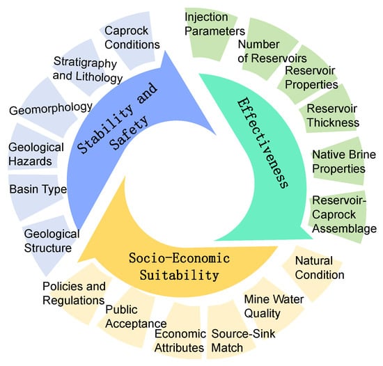
-
Evaluating CHIRPS and ERA5 for Long-Term Runoff Modelling with SWAT in Alpine Headwaters
-
Characterizing Hot-Water Consumption at Household and End-Use Levels Based on Smart-Meter Data
-
Making Sense of Unsustainable Realities: Hydropower and the Sustainable Development Goals
-
Sediment Transport Constraints for Restoration of the Ebro Delta
-
Comparative Analysis of Livestock Wastewater Reuse Under Summer and Winter Conditions at a Scale-Down Microalgae Culture
Journal Description
Water
Water
is a peer-reviewed, open access journal on water science and technology, including the ecology and management of water resources, and is published semimonthly online by MDPI. Water collaborates with the Stockholm International Water Institute (SIWI). In addition, the American Institute of Hydrology (AIH), The Polish Limnological Society (PLS) and Japanese Society of Physical Hydrology (JSPH) are affiliated with Water and their members receive a discount on the article processing charges.
- Open Access— free for readers, with article processing charges (APC) paid by authors or their institutions.
- High Visibility: indexed within Scopus, SCIE (Web of Science), Ei Compendex, GEOBASE, GeoRef, PubAg, AGRIS, CAPlus / SciFinder, Inspec, and other databases.
- Journal Rank: JCR - Q2 (Water Resources) / CiteScore - Q1 (Aquatic Science)
- Rapid Publication: manuscripts are peer-reviewed and a first decision is provided to authors approximately 19.1 days after submission; acceptance to publication is undertaken in 2.6 days (median values for papers published in this journal in the first half of 2025).
- Recognition of Reviewers: reviewers who provide timely, thorough peer-review reports receive vouchers entitling them to a discount on the APC of their next publication in any MDPI journal, in appreciation of the work done.
- Companion journals for Water include: GeoHazards.
- Journal Clusters of Water Resources: Water, Journal of Marine Science and Engineering, Hydrology, Resources, Oceans, Limnological Review, Coasts.
Impact Factor:
3.0 (2024);
5-Year Impact Factor:
3.3 (2024)
Latest Articles
Analysis of the Characteristics and Influencing Factors of Carbon and Water Fluxes in the Restored Sites of Puding, Guizhou Province
Water 2025, 17(16), 2409; https://doi.org/10.3390/w17162409 - 14 Aug 2025
Abstract
This study investigates the microclimate characteristics and temporal variations in carbon and water fluxes in the naturally restored plots in Puding County, Anshun City, Guizhou Province. Continuous monitoring and collection of environmental factors through the eddy covariance system reveals the dynamic change patterns
[...] Read more.
This study investigates the microclimate characteristics and temporal variations in carbon and water fluxes in the naturally restored plots in Puding County, Anshun City, Guizhou Province. Continuous monitoring and collection of environmental factors through the eddy covariance system reveals the dynamic change patterns of the microclimate environment in the early stages of returning farmland to forest and the dynamic characteristics of carbon and water fluxes in the ecosystem. The results show that the study area exhibits a pronounced carbon sink capacity at the annual scale. The net ecosystem exchange (NEE) gradually increased with the extension of the recovery time, and the carbon sink intensity reached its peak during the growing season (June–August). The water use efficiency (WUE) was significantly higher in the growing season compared to the non-growing season, indicating that the WUE and carbon sequestration capacity increased simultaneously. Structural equation model (SEM) analysis revealed that latent heat flux has the most significant regulatory effect on carbon sink function. Furthermore, temperature, relative humidity, and latent heat flux have a significant positive regulatory effect on NEE (p < 0.001), while rain and soil heat flux affect carbon sink function through an indirect path. By constructing a complex meteorological carbon flux relationship network, the main regulatory mechanism of the ecosystem carbon sink in the Puding area was revealed. These findings confirm that the implementation of returning farmland to forest has effectively enhanced the carbon sequestration capacity of karst ecosystems.
Full article
(This article belongs to the Section Biodiversity and Functionality of Aquatic Ecosystems)
Open AccessArticle
Sediment Dynamics and Erosion in a Complex Coastal Lagoon System in the Southern Gulf of Mexico
by
Rosalinda Monreal-Jiménez, Noel Carbajal, Víctor Kevin Contreras-Tereza and David Salas-Monreal
Water 2025, 17(16), 2408; https://doi.org/10.3390/w17162408 - 14 Aug 2025
Abstract
The complex lagoon system of Carmen, Pajonal, and Machona in the Southern Gulf of Mexico is characterized by highly active sedimentary dynamics. To reproduce the sedimentary dynamics processes, the MOHID model, coupled with the SWAN wave model, was applied to different scenarios through
[...] Read more.
The complex lagoon system of Carmen, Pajonal, and Machona in the Southern Gulf of Mexico is characterized by highly active sedimentary dynamics. To reproduce the sedimentary dynamics processes, the MOHID model, coupled with the SWAN wave model, was applied to different scenarios through a climatic analysis of winds. Historical wind data indicate that the region has experienced a significant shift in the principal wind component over the last two decades. Furthermore, hurricanes have impacted the lagoon system on multiple occasions in recent decades. Five numerical experiments were conducted, considering both historical and present-day wind conditions, the impact of Hurricane Larry, and engineering works such as breakwaters, to better understand the sedimentary dynamics of the lagoon system. Model results revealed intense and variable sediment transport depending on the intensity and direction of the prevailing winds, waves, extreme weather events, and breakwater locations.
Full article
(This article belongs to the Section Water Erosion and Sediment Transport)
Open AccessArticle
Species-Specific Element Accumulation in Mollusc Shells: A Framework for Trace Element-Based Marine Environmental Biomonitoring
by
Sergey V. Kapranov, Larisa L. Kapranova, Elena V. Gureeva, Vitaliy I. Ryabushko, Juliya D. Dikareva and Sophia Barinova
Water 2025, 17(16), 2407; https://doi.org/10.3390/w17162407 - 14 Aug 2025
Abstract
Mollusc shells serve as valuable biogeochemical archives of natural or anthropogenic processes occurring in the aquatic environment throughout the life of the molluscs. One such process is trace element pollution, which can be assessed by analyzing the elemental composition of mollusc shells. However,
[...] Read more.
Mollusc shells serve as valuable biogeochemical archives of natural or anthropogenic processes occurring in the aquatic environment throughout the life of the molluscs. One such process is trace element pollution, which can be assessed by analyzing the elemental composition of mollusc shells. However, different mollusc species accumulate elements in their shells from the aquatic environment at varying concentrations, and specific patterns of this accumulation remain largely unknown. In the present study, we measured the concentrations of 33 elements in the shells of five commercially important Black Sea molluscs, all collected from the same site, using inductively coupled plasma mass spectrometry. The species were ranked according to the number of elements with the highest concentrations in their shells as follows: Crassostrea gigas (9) = Rapana venosa (9) = Anadara kagoshimensis (9) > Flexopecten glaber ponticus (4) > Mytilus galloprovincialis (2). Cluster analysis of Pearson’s coefficients of correlation of elemental concentrations in the molluscan shells revealed significant separation of C. gigas, F. glaber ponticus, and M. galloprovincialis. Multivariate ordination analyses allowed the accurate classification of >92.3% of shell samples using as few as four elements (Fe, As, Sr, and I). Linear discriminant analysis revealed the probability of separation of all species based on the concentrations of these elements in their shells being not lower than 79%. The applied multivariate approach based on the analysis of four base elements in shells can help not only in the taxonomic identification of molluscs, but also, upon appropriate calibration, in monitoring medium-term dynamics of trace elements in the aquatic environment.
Full article
(This article belongs to the Special Issue Marine Pollution and Ecotoxicology: Characteristics, Risks and Strategies)
Open AccessArticle
Tracing Heavy Metal Pollution in the Romanian Black Sea: A Multi-Matrix Study of Contaminant Profiles and Ecological Risk Across the Continental Shelf and Beyond
by
Andra Oros, Dragos Marin, Gulten Reiz and Robert Daniel Nenita
Water 2025, 17(16), 2406; https://doi.org/10.3390/w17162406 - 14 Aug 2025
Abstract
This study provides a comprehensive six-year assessment (2018–2023) of heavy metal contamination in the Romanian Black Sea sector, integrating data from seawater, surface sediments, and benthic mollusks. Sampling was conducted across a broad spatial gradient, including transitional, coastal, shelf, and offshore waters beyond
[...] Read more.
This study provides a comprehensive six-year assessment (2018–2023) of heavy metal contamination in the Romanian Black Sea sector, integrating data from seawater, surface sediments, and benthic mollusks. Sampling was conducted across a broad spatial gradient, including transitional, coastal, shelf, and offshore waters beyond 200 m depth. Concentrations of six potentially toxic metals, including cadmium (Cd), lead (Pb), nickel (Ni), chromium (Cr), copper (Cu), and cobalt (Co), were measured to evaluate regional variability, potential sources, and ecological implications. Results indicate some exceedances of regulatory thresholds for Cd and Pb in transitional and coastal waters, associated with Danube River input and coastal pressures. Seabed substrate analysis revealed widespread enrichment in Ni, moderate levels of Cr, and sporadic Cd elevation in Danube-influenced areas, along with localized hotspots of Cu and Pb near port and industrial zones. Biological uptake patterns in mollusks (bivalves Mytilus galloprovincialis and Anadara inequivalvis and gastropod Rapana venosa) highlighted Cd among key metals of concern, with elevated Bioconcentration Factor (BCF) and Biota–Sediment Accumulation Factor (BAF). Offshore waters generally exhibited lower pollution levels. However, isolated exceedances, such as Cr outliers recorded in 2022, suggest that deep-sea inputs from atmospheric or maritime sources may be both episodic in nature and underrecognized due to limited monitoring coverage. The combined use of water, sediment, and biota data emphasize the strength of multi-matrix approaches in marine pollution evaluation, revealing persistent nearshore pressures and less predictable offshore anomalies. These findings contribute to a more complete understanding of heavy metal distribution in the northwestern Black Sea and provide a scientific basis for improving long-term environmental monitoring and risk management strategies in the region.
Full article
(This article belongs to the Special Issue Marine Pollution and Ecotoxicology: Characteristics, Risks and Strategies)
►▼
Show Figures

Figure 1
Open AccessArticle
Trophic Ecology of Slender Snipe Eel Nemichthys scolopaceus Richardson, 1848 (Anguilliformes: Nemichthyidae) in the Central Mediterranean Sea
by
Andrea Geraci, Andrea Scipilliti, Ylenia Guglielmo, Chiara Lauritano, Adriana Profeta, Roberta Minutoli, Francesca Veneziano, Davide Di Paola, Daniela Massi, Letterio Guglielmo, Pierluigi Carbonara and Antonia Granata
Water 2025, 17(16), 2405; https://doi.org/10.3390/w17162405 - 14 Aug 2025
Abstract
The slender snipe eel Nemichthys scolopaceus Richardson, 1848 is cosmopolitan in tropical and temperate seas, inhabiting the mesopelagic and bathypelagic zone between 200 and 1000 m depth. It is known to be an active predator in the DSL (Deep Scattering Layer) and the
[...] Read more.
The slender snipe eel Nemichthys scolopaceus Richardson, 1848 is cosmopolitan in tropical and temperate seas, inhabiting the mesopelagic and bathypelagic zone between 200 and 1000 m depth. It is known to be an active predator in the DSL (Deep Scattering Layer) and the NBA (Near Bottom Aggregation), feeding mostly on decapod and euphausiid crustaceans, and playing a central role in carbon fluxes through meso- and bathypelagic ecosystems. Despite its potential importance in the deep trophic web ecosystem, the trophic ecology of Nemichthys scolopaceus is not well known. The aim of this study was to start to fill this knowledge gap. A total of 35 specimens of N. scolopaceus caught through bottom trawling in the Mediterranean Sea were analyzed in the laboratory for stomach content composition. As expected, mainly decapod crustaceans were found, in particular Plesionika martia, Pasiphaea multidentata, Funchalia woodwardi, and Robustosergia robusta species. The degree of digestion of prey in the stomachs was high in all cases. Our findings seem to confirm the specialist diet of Nemichthys scolopaceus based on shrimp-like crustaceans.
Full article
(This article belongs to the Section Biodiversity and Functionality of Aquatic Ecosystems)
Open AccessArticle
Numerical Simulation of a Heat Exchanger with Multiturn Piping and Performance Optimization
by
Zheng Jiang, Lei Wang, Shen Hu and Wenwen Zhang
Water 2025, 17(16), 2404; https://doi.org/10.3390/w17162404 - 14 Aug 2025
Abstract
The heat exchanger in a hydropower unit plays a critical role in ensuring the stability of the unit and improving operational efficiency. This paper conducted a global flow-field/heat-transfer numerical analysis of multi-tube heat exchangers in hydropower units (with 98 tubes) and applied it
[...] Read more.
The heat exchanger in a hydropower unit plays a critical role in ensuring the stability of the unit and improving operational efficiency. This paper conducted a global flow-field/heat-transfer numerical analysis of multi-tube heat exchangers in hydropower units (with 98 tubes) and applied it to optimization research under actual operating conditions. Using a three-dimensional two-phase flow model, this work systematically analyzes the effects of different sand content and particle size on heat-transfer performance, revealing the impact of particle-flow and fluid-flow nonuniformity on heat-exchange efficiency. This research fills the gap in existing studies regarding the analysis of the impact of complex operating conditions on hydropower unit radiators. To address the issues of nonuniform flow fields and poor flow mixing in existing heat exchangers, an improved inlet/outlet structural-optimization plan is proposed. The original cylindrical inlet/outlet is replaced with a square structure, and its area is increased. The optimized structure improves flow uniformity, reduces flow losses, enhances heat-transfer performance by 7.7%, and achieves a significant reduction of 0.53 K in oil temperature. The findings of this study provide theoretical and engineering guidance for the design and optimization of heat exchangers in hydropower units and are of high value for practical applications.
Full article
(This article belongs to the Special Issue Research Status of Operation and Management of Hydropower Station)
Open AccessArticle
Measurement of Cross-Regional Ecological Compensation Standards from a Dual Perspective of Costs and Benefits
by
Jun Ma, Xiaoying Gu and Qiuyu Chen
Water 2025, 17(16), 2403; https://doi.org/10.3390/w17162403 - 14 Aug 2025
Abstract
Establishing scientifically sound and equitable compensation standards is crucial for effective ecological compensation. This study focuses on the quantitative assessment of ecological compensation standards in the water-source areas of the South-to-North Water Diversion Project. Based on the dual perspective of cost and benefit,
[...] Read more.
Establishing scientifically sound and equitable compensation standards is crucial for effective ecological compensation. This study focuses on the quantitative assessment of ecological compensation standards in the water-source areas of the South-to-North Water Diversion Project. Based on the dual perspective of cost and benefit, we embed a three-dimensional dynamic adjustment coefficient—water volume, water quality, and payment capacity—and fully considered spillover effects. Using the AHP-Entropy Method, the allocation ratio of the water-receiving area was scientifically divided, achieving differentiated distribution and dynamic adaptation of the compensation mechanism. The compensation allocation ratio for water-receiving areas was determined, ensuring differentiated distribution and dynamic adaptability in the compensation mechanism. The results show the following: (1) In 2023, the ecological compensation amount for Yangzhou, based on the cost method and the equivalent factor method, ranges from CNY 1.21 billion to 2.53 billion. The amount of compensation after the dynamic game between both parties can avoid the waste of resources caused by over-compensation, and at the same time make up for the shortcomings of under-compensation due to the current water price. (2) Ecological compensation is measured only from the single perspective of the water-source area, without considering the differences in the receiving area. This paper uses the AHP-entropy value method to combine and assign weights, and calculates the apportionment ratio of the main water-receiving areas of Shandong Province in the east line of the South-to-North Water Diversion: for the Jiaodong line, these are Qingdao 20.97% and Jinan 14.53%, and for the North Shandong line, they are Dongying 23.98%, Dezhou 13.68%, Liaocheng 9.47%, and Binzhou 17.37%. (3) The dynamic correction coefficient and game model can effectively balance the cost of protecting the water-source area and the receiving area’s ability to pay, and combination with the empowerment method enhances the regional difference in suitability.
Full article
(This article belongs to the Section Water Resources Management, Policy and Governance)
Open AccessArticle
Microbiome and Chemistry Insights into Two Oligotrophic Karst Water Springs in Slovenia from 2016 and 2023 Perspectives
by
Mojca Likar, Marko Blagojevič, Maša Ošlak, Matjaž Mikoš, Zala Prevoršek, Ladislav Holko, Dragana Ribič, Blaž Likozar, Uroš Novak, Boštjan Murovec, Sabina Kolbl Repinc and Blaž Stres
Water 2025, 17(16), 2402; https://doi.org/10.3390/w17162402 - 14 Aug 2025
Abstract
Groundwater, a critical source of drinking water, plays an essential role in global biogeochemical cycles, yet its microbial ecosystems remain insufficiently characterized, particularly in pristine karst aquifers. This study conducted high-resolution profiling of microbial communities and environmental parameters in two representative alpine karst
[...] Read more.
Groundwater, a critical source of drinking water, plays an essential role in global biogeochemical cycles, yet its microbial ecosystems remain insufficiently characterized, particularly in pristine karst aquifers. This study conducted high-resolution profiling of microbial communities and environmental parameters in two representative alpine karst aquifers in Slovenia: Idrijska Bela and Krajcarca. Monthly groundwater samples from the Krajcarca spring and Idrijska Bela borehole over a 14-month period were analyzed using whole-metagenome sequencing (WMS), UV-Vis spectroscopy, inductively coupled plasma mass spectrometry (ICP-MS), and isotopic analysis. The results revealed stable hydrochemical conditions with clear spatial differences driven by bedrock composition and groundwater residence time. Bacterial communities displayed strong correlations with hydrochemical parameters, while archaeal communities exhibited temporal stability. Functional gene profiles mirrored bacterial patterns, emphasizing the influence of environmental gradients on metabolic potential. No significant temporal changes were detected across two sampling campaigns (2016–2023), highlighting the resilience of these aquifers. This work establishes a valuable baseline for understanding pristine groundwater microbiomes and informs future monitoring and water quality management strategies.
Full article
(This article belongs to the Section Water Quality and Contamination)
►▼
Show Figures

Figure 1
Open AccessArticle
A Performance Evaluation and Statistical Analysis of IMERG Precipitation Products During Medicane Daniel (September 2023) in the Thessaly Plain, Greece
by
Evangelos Leivadiotis and Aris Psilovikos
Water 2025, 17(16), 2401; https://doi.org/10.3390/w17162401 - 14 Aug 2025
Abstract
The precise estimation of precipitation is key to understanding and mitigating the effects of extreme weather conditions, especially in areas susceptible to Mediterranean cyclones. This work assesses the performance of the integrated multi-satellite retrievals for GPM (IMERG) precipitation products during the extreme Mediterranean
[...] Read more.
The precise estimation of precipitation is key to understanding and mitigating the effects of extreme weather conditions, especially in areas susceptible to Mediterranean cyclones. This work assesses the performance of the integrated multi-satellite retrievals for GPM (IMERG) precipitation products during the extreme Mediterranean cyclone “Medicane Daniel” that affected the Thessaly Plain in Central Greece in early September 2023. Three IMERG versions (final run (FR), early run (ER), and late run (LR)) were inter-compared with gauge-based interpolated rainfall estimates using inverse distance weighting (IDW) and ordinary kriging techniques. Pixel-wise and categorical verification metrics, such as the probability of detection (POD), false alarm ratio (FAR), critical success index (CSI), and Peirce skill score (PSS), were calculated for rainfall thresholds between 50 mm and 400 mm. It was found that the IMERG final run agreed most with the ground observations, with a correlation coefficient (R) of 0.87, RMSE of 138.8 mm, and CSI up to 0.995 at the 100 mm threshold when the IDW interpolation was used. Kriging produced slightly better spatial accuracy overall, as indicated by a lower RMSE (14.5 mm) and higher correlation (R = 0.99). The results indicate the benefit of combining satellite precipitation data with ground-based observations through spatial interpolation for the enhanced monitoring of extreme weather events over complex terrain. Kriging is suggested when greater spatial reliability is needed, while IMERG-FR is found to be a reliable satellite product for quick response analysis during heavy precipitation events. The study emphasizes the importance of blending satellite precipitation estimates and ground observations via spatial interpolation methods, i.e., kriging and IDW, allowing for a more localized and precise validation of intense weather events.
Full article
(This article belongs to the Special Issue Sustainable and Efficient Water Use in the Face of Climate Change)
►▼
Show Figures

Figure 1
Open AccessArticle
Scale and Reasons for Changes in Chemical Composition of Waters During the Spring Freshet on Kolyma River, Arctic Siberia
by
Vladimir Shulkin, Sergei Davydov, Anna Davydova, Tatiana Lutsenko and Eugeniy Elovskiy
Water 2025, 17(16), 2400; https://doi.org/10.3390/w17162400 - 14 Aug 2025
Abstract
The information on the seasonal variability of the chemical composition of the Arctic rivers is necessary for the proper assessment of the status of river runoff and the influence of anthropogenic and natural factors. Spring freshet is an especially important period for the
[...] Read more.
The information on the seasonal variability of the chemical composition of the Arctic rivers is necessary for the proper assessment of the status of river runoff and the influence of anthropogenic and natural factors. Spring freshet is an especially important period for the Arctic rivers with a sharp maximum of water discharge. The Kolyma River is the least studied large river with a basin located solely in the permafrost zone. The change in the concentration of dissolved organic carbon (DOC), major, trace, and rare earth (RE) elements was studied at the peak and waning of the spring freshet of 2024 in the lower reaches of the Kolyma River. The concentration of elements was determined in filtrates < 0.45 μm and in suspended solids > 0.45 μm. The content of coarse colloids (0.05–0.45 μm) was estimated by the intensity of dynamic light scattering (DLS). It was shown that the freshet peak is characterized by a minimal specific conductivity, concentration of major cations, and chemical elements migrating mainly in solution (Li, Sr, and Ba). During the freshet decline, the concentration of these elements increases with dynamics depending on the water exchange. The waters from the Kolyma River main stream have a maximal content of coarse colloids and concentration of <0.45 μm forms of hydrolysates (Al, Ti, Fe, Mn, REEs, Zr, Y, Sc, and Th), DOC, P, and heavy metals (Cu, Ni, Cd, and Co) at the freshet peak. A decrease of 8–10 times for hydrolysates and coarse colloids (0.05–0.45 μm) and of 3–6 times for heavy metals was observed at the freshet waning during the first half of June. This indicates a large-scale accumulation of easy soluble forms of hydrolysates, DOC, and heavy metals in the seasonal thawing topsoil layer on the catchment upstream in the previous summer, with a flush out of these elements at the freshet peak of the current year. In the large floodplain watercourse Panteleikha River, the change in concentration of major cations and REEs, Zr, Y, Sc, and Th at the freshet is less accented compared with the Kolyma River main stream due to a slower water exchange. Yet, <0.45 μm forms of Fe, Mn, Co, As, V, and P show an increase of 4–6 times in the Panteleikha River in the second half of June compared with the freshet peak, which indicates an additional input of these elements from the thawing floodplain landscapes and bottom sediments of floodplain watercourses. The concentration of the majority of chemical elements in suspended matter (>0.45 μm) of the Kolyma River is rather stable during the high-water period. The relative stability in the chemical composition of the suspended solids means that the content of the suspension and not its composition is the key to the share of dissolved and suspended forms of chemical elements in the Kolyma River runoff.
Full article
(This article belongs to the Special Issue Hydrological and Hydrochemical Drivers of Solute Export from Watersheds)
Open AccessArticle
Simulation of Sediment Dynamics in a Large Floodplain of the Danube River
by
Dara Muhammad Hawez, Vivien Füstös, Flóra Pomázi, Enikő Anna Tamás and Sándor Baranya
Water 2025, 17(16), 2399; https://doi.org/10.3390/w17162399 - 14 Aug 2025
Abstract
This study presents a two-dimensional (2D) hydro-morphodynamic simulation of sediment dynamics in the Gemenc floodplain, a critical ecological zone along Hungary’s Danube River. The 60 km study area has a mean discharge of approximately 2300 m3/s, with peak floods exceeding 8000
[...] Read more.
This study presents a two-dimensional (2D) hydro-morphodynamic simulation of sediment dynamics in the Gemenc floodplain, a critical ecological zone along Hungary’s Danube River. The 60 km study area has a mean discharge of approximately 2300 m3/s, with peak floods exceeding 8000 m3/s. The objective was to analyze sediment transport, deposition, and flood hydrodynamics to support future floodplain restoration. The HEC-RAS 2D model was calibrated using water levels (Baja station), 2024 flood discharges, suspended sediment measurements, and visual stratigraphy surveys conducted after the event. A roughness sensitivity analysis was conducted to optimize Manning’s n values for various land covers. The hydrodynamic model showed strong agreement with observed hydrographs and discharge distributions across multiple cross-sections, capturing complex bidirectional flow between the main River and side branches. Sediment dynamics during the September 2024 Danube flood were effectively simulated, with SSC calibration showing a decreasing concentration trend, highlighting the floodplain’s function as a sediment trap. Predicted deposition patterns aligned with field-based visual stratigraphy, confirming high sediment accumulation near riverbanks and reduced deposition in distal zones. The model reproduced deposition thickness with acceptable variation, demonstrating spatial reliability and predictive strength. This study underscores the value of 2D modeling for integrating hydrodynamics and sediment transport to inform sustainable floodplain rehabilitation.
Full article
(This article belongs to the Special Issue Advances in River Restoration and Sediment Transport Management)
►▼
Show Figures

Figure 1
Open AccessArticle
Hydraulic Performance of an Angled Oppermann Fine Screen with Guidance Wall
by
Cumhur Ozbey, Serhat Kucukali and Reinhard Hassinger
Water 2025, 17(16), 2398; https://doi.org/10.3390/w17162398 - 14 Aug 2025
Abstract
Fish protection and guidance are critical factors in the design and operation of water intakes at hydropower plants. In this study, the hydraulic performance of the angled Oppermann fine screen has been investigated in a hybrid model with and without a guidance wall.
[...] Read more.
Fish protection and guidance are critical factors in the design and operation of water intakes at hydropower plants. In this study, the hydraulic performance of the angled Oppermann fine screen has been investigated in a hybrid model with and without a guidance wall. The experiments were conducted under two different angles of 30° and 45°, and a bar spacing of 10 mm at a large-scale flume with a width of 2 m. Just up- and downstream of the screen, three-dimensional velocities were measured with Acoustic Doppler Velocimetry (ADV). In the computational fluid dynamics (CFD) model, the Large Eddy Simulation (LES) coupled with the Darcy–Forchheimer law, in which screens were modeled as homogeneous porous media, was employed. The experimental results revealed that velocities less than 0.5 m/s just upstream of the Oppermann fine screen and tangential velocity gradients over the entire cross-section of the screen were found to be 0.04–0.338 m/s/m and 0.04–0.856 m/s/m for α = 30° and α = 45°, respectively, creating favorable hydraulic conditions for effective downstream fish guidance. The CFD model was validated against the experimental data within an acceptable error range, both for the velocity and the turbulent kinetic energy. Numerical simulations showed that implementing a curved guidance wall creates a symmetrical and homogeneous downstream flow field without the formation of recirculation zones behind the angled screen.
Full article
(This article belongs to the Section Hydraulics and Hydrodynamics)
►▼
Show Figures

Figure 1
Open AccessArticle
Analysis of Groundwater Chemical Characteristics and Boron Sources in the Oasis Area of the Cherchen River Basin in Xinjiang, China
by
Jiangwei Dong, Fuxiang Gao, Jinlong Zhou, Jiang Li and Yinzhu Zhou
Water 2025, 17(16), 2397; https://doi.org/10.3390/w17162397 - 14 Aug 2025
Abstract
The oasis area of the Cherchen River Basin (OACRB) is located in the southeast edge of the Tarim Basin in Xinjiang, China. High boron (B) groundwater is observed in the OACRB according to 40 groundwater samples collected in May 2023. Identification of the
[...] Read more.
The oasis area of the Cherchen River Basin (OACRB) is located in the southeast edge of the Tarim Basin in Xinjiang, China. High boron (B) groundwater is observed in the OACRB according to 40 groundwater samples collected in May 2023. Identification of the chemical characteristics and B sources of groundwater in the OACRB is of great significance for the sustainable development and utilization of groundwater resources and the protection of animals, plants and human health. To explore the chemical characteristics and main B sources of groundwater, Piper three-line diagram, Gibbs diagram, correlation analysis, hydrogeochemical simulation and absolute principal component analysis (PCA-APCS-MLR) were used for analysis. The contribution of different factors to groundwater B was quantitatively evaluated. The results showed that the groundwater is weakly alkaline (with an average pH of 7.94) and mainly brackish water and saline water with Cl− and Na+ as the main anions and cations. The groundwater is dominated by SO4 · Cl-Na type. The average concentration (ρ) of groundwater B in the study area was 1.48 mg·L−1 with the over-standard rate was 45.0%. The APCS-MLR receptor model analysis revealed that groundwater chemical components including B were mainly derived from leaching-enrichment, human activity, primary geological factors, and unknown sources. Groundwater B is obviously greater than the standard limit, which is mainly due to agricultural activities (fertilizers and pesticides) and unknown sources.
Full article
(This article belongs to the Topic The Hydrosphere in Crisis: Human Impact, Climate Change, and Pathways to Resilience, 2nd Edition)
►▼
Show Figures

Figure 1
Open AccessArticle
Removal of Ibuprofen and Paracetamol by Rhizobacteria from Roots of Scirpus grossus Exposed to a Synthetic Mix in Constructed Wetlands
by
Osama Abrahiem AL Falahi, Siti Rozaimah Sheikh Abdullah, Hassimi Abu Hasan, Ahmad Razi Othman, Hind Mufeed Ewadh, Nur ‘Izzati Ismail, Muhammad Fauzul Imron and Setyo Budi Kurniawan
Water 2025, 17(16), 2396; https://doi.org/10.3390/w17162396 - 13 Aug 2025
Abstract
The presence of ibuprofen (IBP) and paracetamol (PAR) contaminants in wastewater has become an emerging issue. Traditional wastewater treatment facilities have not been adequately upgraded to remove these micropollutants. This study focused on screening and identifying effective rhizobacteria capable of assisting plants in
[...] Read more.
The presence of ibuprofen (IBP) and paracetamol (PAR) contaminants in wastewater has become an emerging issue. Traditional wastewater treatment facilities have not been adequately upgraded to remove these micropollutants. This study focused on screening and identifying effective rhizobacteria capable of assisting plants in eliminating ibuprofen and paracetamol from wastewater using constructed wetlands. A total of 28 rhizobacteria were isolated from both the roots and the surrounding sand of Scirpus grossus after 30 days of pharmaceutical exposure. Among these, three isolates (Gram-negative Enterobacter aerogenes, Gram-positive Bacillus flexus, and Paenibacillus alvei) showed high tolerance to IBP and PAR with initial removal efficiencies > 75%. The addition of these three isolated rhizobacteria to a constructed wetland (planted with Scirpus grossus, 5-day HRT, 2 L/min aeration) assists the removal of IBP and PAR from wastewater. Bioaugmentation of rhizobacteria showed an increment of IBP removal (↑13%) from water (residual of 10 µg/L) and PAR (↑20%) from sand (residual 2.3 µg/L) as compared to the non-bioaugmented systems. The addition of rhizobacteria also showed the ability to significantly enhance the translocation of PAR into the shoot system of S. grossus, suggesting assisted phytoextraction mechanisms, while the removal of IBP in wetlands is suggested to occur via rhizodegradation. It is recommended that future research be conducted to elucidate the microbial degradation pathways and analyze the intermediate metabolites to accurately depict the pharmaceutical degradation mechanisms and evaluate their ecological risks.
Full article
(This article belongs to the Section Wastewater Treatment and Reuse)
►▼
Show Figures

Figure 1
Open AccessArticle
The Influence of Seasonal Freeze–Thaw in Northeast China on Greenhouse Gas Emissions and Microbial Community Structure in Peat Soil
by
Yanru Gong, Tao Yang, Jiawen Yan and Xiaofei Yu
Water 2025, 17(16), 2395; https://doi.org/10.3390/w17162395 - 13 Aug 2025
Abstract
Peat soil is a significant global carbon storage pool, accounting for one-third of the global soil carbon pool. Its greenhouse gas emissions have a significant impact on climate change. Seasonal freeze–thaw cycles are common natural phenomena in high-latitude and high-altitude regions. They significantly
[...] Read more.
Peat soil is a significant global carbon storage pool, accounting for one-third of the global soil carbon pool. Its greenhouse gas emissions have a significant impact on climate change. Seasonal freeze–thaw cycles are common natural phenomena in high-latitude and high-altitude regions. They significantly affect the mineralization of soil organic carbon and greenhouse gas emissions by altering the physical structure, moisture conditions, and microbial communities of the soil. In this study, through the construction of an indoor simulation experiment of the typical freeze–thaw cycle models in spring and autumn in the Greater Xing‘an Range region of China and the Jinchuan peatland of Jilin Longwan National Nature Reserve, the physicochemical properties, greenhouse gas emission fluxes, microbial community structure characteristics, and key metabolic pathways of peat soils in permafrost and seasonally frozen ground areas were determined. The characteristics of greenhouse gas emissions and their influencing mechanisms for peat soil in northern regions under different freeze–thaw conditions were explored. The research found that the freeze–thaw cycle significantly changed the chemical properties of peat soil and significantly affected the emission rates of CO2, CH4, and N2O. It also clarified the interaction relationship between soil’s physicochemical properties (such as dissolved organic carbon (DOC), dissolved organic nitrogen (DON), ammonium nitrogen (NH4+), soil organic carbon (SOC), etc.) and the structure and metabolic function of microbial communities. It is of great significance for accurately assessing the role of peatlands in the global carbon cycle and formulating effective ecological protection and management strategies.
Full article
(This article belongs to the Section Soil and Water)
►▼
Show Figures

Figure 1
Open AccessArticle
Spatiotemporal Patterns of Algal Blooms in Lake Bosten Driven by Climate and Human Activities: A Multi-Source Remote-Sensing Perspective for Sustainable Water-Resource Management
by
Haowei Wang, Zhoukang Li, Yang Wang and Tingting Xia
Water 2025, 17(16), 2394; https://doi.org/10.3390/w17162394 - 13 Aug 2025
Abstract
Algal blooms pose a serious threat not only to the lake ecosystem of Lake Bosten but also by negatively impacting its rapidly developing fisheries and tourism industries. This study focuses on Lake Bosten as the research area and utilizes multi-source remote sensing imagery
[...] Read more.
Algal blooms pose a serious threat not only to the lake ecosystem of Lake Bosten but also by negatively impacting its rapidly developing fisheries and tourism industries. This study focuses on Lake Bosten as the research area and utilizes multi-source remote sensing imagery from Landsat TM/ETM+/OLI and Sentinel-2 MSI. The Adjusted Floating Algae Index (AFAI) was employed to extract algal blooms in Lake Bosten from 2004 to 2023, analyze their spatiotemporal evolution characteristics and driving factors, and construct a Long Short Term Memory (LSTM) network model to predict the spatial distribution of algal-bloom frequency. The stability of the model was assessed through temporal segmentation of historical data combined with temporal cross-validation. The results indicate that (1) during the study period, algal blooms in Lake Bosten were predominantly of low-risk level, with low-risk bloom coverage accounting for over 8% in both 2004 and 2005. The intensity of algal blooms in summer and autumn was significantly higher than in spring. The coverage of medium- and high-risk blooms reached 2.74% in the summer of 2004 and 3.03% in the autumn of 2005, while remaining below 1% in spring. (2) High-frequency algal bloom areas were mainly located in the western and northwestern parts of the lake, and the central region experienced significantly more frequent blooms during 2004–2013 compared to 2014–2023, particularly in spring and summer. (3) The LSTM model achieved an R2 of 0.86, indicating relatively stable performance. The prediction results suggest a continued low frequency of algal blooms in the future, reflecting certain achievements in sustainable water-resource management. (4) The interactions among meteorological factors exhibited significant influence on bloom formation, with the q values of temperature and precipitation interactions both exceeding 0.5, making them the most prominent meteorological driving factors. Monitoring of sewage discharge and analysis of agricultural and industrial expansion revealed that human activities have a more direct impact on the water quality of Lake Bosten. In addition, changes in lake area and water environment were mainly influenced by anthropogenic factors, ultimately making human activities the primary driving force behind the spatiotemporal variations of algal blooms. This study improved the timeliness of algal-bloom monitoring through the integration of multi-source remote sensing and successfully predicted the future spatial distribution of bloom frequency, providing a scientific basis and decision-making support for the sustainable management of water resources in Lake Bosten.
Full article
(This article belongs to the Special Issue Use of Remote Sensing Technologies for Water Resources Management)
►▼
Show Figures

Figure 1
Open AccessArticle
Integrated Multivariate and Spatial Assessment of Groundwater Quality for Sustainable Human Consumption in Arid Moroccan Regions
by
Yousra Tligui, El Khalil Cherif, Wafae Lechhab, Touria Lechhab, Ali Laghzal, Nordine Nouayti, El Mustapha Azzirgue, Joaquim C. G. Esteves da Silva and Farida Salmoun
Water 2025, 17(16), 2393; https://doi.org/10.3390/w17162393 - 13 Aug 2025
Abstract
Groundwater quality in arid and semi-arid regions of Morocco is under increasing pressure due to both anthropogenic influences and climatic variability. This study investigates the physicochemical and heavy metal characteristics of groundwater across four Moroccan regions (Tangier-Tetouan-Al Hoceima, Oriental, Souss-Massa, and Marrakech-Safi) known
[...] Read more.
Groundwater quality in arid and semi-arid regions of Morocco is under increasing pressure due to both anthropogenic influences and climatic variability. This study investigates the physicochemical and heavy metal characteristics of groundwater across four Moroccan regions (Tangier-Tetouan-Al Hoceima, Oriental, Souss-Massa, and Marrakech-Safi) known for being argan tree habitats. Thirteen groundwater samples were analyzed for twenty-five parameters, including major ions, nutrients, and trace metals. Elevated levels of ammonium, turbidity, electrical conductivity, and dissolved oxygen were observed in multiple samples, surpassing Moroccan water quality standards and indicating significant quality deterioration. Inductively Coupled Plasma-Atomic Emission Spectroscopy (ICP-AES) detected arsenic concentrations exceeding permissible limits in sample AW11 alongside widespread lead contamination in most samples except AW5 and AW9. Spatial patterns of contamination were characterized using Principal Component Analysis (PCA), Hierarchical Cluster Analysis (HCA), K-means clustering, and GIS-based Inverse Distance Weighted (IDW) interpolation. These multivariate approaches revealed marked spatial heterogeneity and highlighted the dual influence of geogenic processes and anthropogenic activities on groundwater quality. To assess consumption suitability, a Water Quality Index (WQI) and Human Health Risk Assessment were applied. As a result, 31% of samples were rated “Fair” and 69% as “Good”, but with notable non-carcinogenic risks, particularly to children, attributable to nitrate, lead, and arsenic. The findings underscore the urgent need for systematic groundwater monitoring and management strategies to safeguard water resources in Morocco’s vulnerable dryland ecosystems, particularly in regions where groundwater sustains vital socio-ecological species such as argan forests.
Full article
(This article belongs to the Section Water Quality and Contamination)
►▼
Show Figures

Figure 1
Open AccessArticle
Addition of Heterotrophic Nitrification and Aerobic Denitrification Bacterial Agents to Enhance Bio-Nests Treating Low Carbon-to-Nitrogen Ratio Municipal Wastewater
by
Qingxin Diao, Chaolin Quan, Wanmeng Li, Xiangtong Zhou, Zhigang Liu, Xinshan Rong, Zhishui Liang, Xiao Wang and Zhiren Wu
Water 2025, 17(16), 2392; https://doi.org/10.3390/w17162392 - 13 Aug 2025
Abstract
Municipal wastewater with a low carbon-to-nitrogen (C/N) ratio presents challenges for conventional nitrogen removal processes, often requiring costly external carbon sources. This study investigated the enhancement of nitrogen removal in a simultaneous nitrification and denitrification (SND) system by incorporating heterotrophic nitrification and aerobic
[...] Read more.
Municipal wastewater with a low carbon-to-nitrogen (C/N) ratio presents challenges for conventional nitrogen removal processes, often requiring costly external carbon sources. This study investigated the enhancement of nitrogen removal in a simultaneous nitrification and denitrification (SND) system by incorporating heterotrophic nitrification and aerobic denitrification (HN-AD) bacterial agents (Klebsiella variicola L3, Acinetobacter beijerinckii W4, and Acinetobacter sp. Z1) with modified basalt fiber carriers. Three reactors were compared: mixed HN-AD strains (M), mixed strains with activated sludge (A+M), and activated sludge alone (A). Results demonstrated that the A+M reactor achieved superior performance, with median removal efficiencies of 82.2% for NH4+-N, 52.9% for total nitrogen (TN), and 51.6% for COD, outperforming the M reactor (75.2%, 43.6%, and 51.6%) and the A reactor (63.2%, 29.3%, and 44.8%). The A+M reactor also exhibited a 40% reduction in COD consumption per unit TN removed (2.55 ± 1.75) compared to the control reactor A (4.25 ± 3.99). Microbial analysis revealed Acinetobacter sp. Z1 (6.1%) and K. variicola L3 (1.1%) as dominant species, with the A+M reactor showing higher microbial diversity (56.4% Proteobacteria, 10.2% Bacteroidota) and biological viability (VSS/SS ratio of 0.70 ± 0.01). Extracellular polymeric substance (EPS) content in A+M reached 242.26 ± 15.52 mg/g-VSS, with a protein-to-polysaccharide ratio of 2.77 ± 0.00, indicating robust biofilm activity. These findings highlight the potential of HN-AD bacterial agents to enhance nitrogen removal in low C/N wastewater treatment, offering a cost-effective and sustainable alternative to traditional methods by reducing reliance on external carbon sources and improving system efficiency.
Full article
(This article belongs to the Special Issue Science and Technology for Water Purification, 2nd Edition)
►▼
Show Figures

Figure 1
Open AccessArticle
Urban Growth and River Course Dynamics: Disconnected Floodplain and Urban Flood Risk in Manohara Watershed, Nepal
by
Shobha Shrestha, Prem Sagar Chapagain, Kedar Dahal, Nirisha Adhikari, Prajjwal Shrestha and Laxmi Manandhar
Water 2025, 17(16), 2391; https://doi.org/10.3390/w17162391 - 13 Aug 2025
Abstract
Human activities and river course change have a complex reciprocal interaction. The river channel is altered by human activity, and these alterations have an impact on the activities and settlements along the riverbank. Understanding the relationship between urbanization and changes in river morphology
[...] Read more.
Human activities and river course change have a complex reciprocal interaction. The river channel is altered by human activity, and these alterations have an impact on the activities and settlements along the riverbank. Understanding the relationship between urbanization and changes in river morphology is crucial for effective river management, safeguarding the urban environment, and mitigating flood hazards. In this context, this study has been conducted to investigate the interrelationship between morphological dynamics, built-up growth, and urban flood risk along the Manohara River in Kathmandu Valley, Nepal. The Sinuosity Index was used to analyze variation in river courses and instability from 1996 to 2023. Built-up change analysis is carried out using supervised maximum likelihood classification method and rate of change is calculated for built-up area growth (2003–2023) and building construction between 2003 and 2021. Flood hazard risk manning was carried out using flood frequency estimation method integrating HEC-GeoRAS modeling. Linear regression and spatial overlay analysis was carried out to examine the interrelationship between river morphology, urban growth, and fold hazed risk. In recent years (2016–2023), the Manohara River has straightened, particularly after 2011. Before 2011, it had significant meandering with pronounced curves and bends, indicating a mature river system. However, the SI value of 1.45 in 2023 and 1.80 in 2003 indicates a significant straightening of high meandering over 20 years. A flood hazard modeling carried out within the active floodplain of the Manohara River shows that 26.4% of the area is under high flood risk and 21% is under moderate risk. Similarly, over 10 years from 2006 to 2016, the rate of built-up change was found to be 9.11, while it was 7.9 between 2011 and 2021. The calculated R2 value of 0.7918 at a significance level of 0.05 (with a p value of 0.0175, and a standard error value of 0.07877) indicates a strong positive relationship between decreasing sinuosity and increasing built-up, which demonstrates the effect of built-up expansion on river morphology, particularly the anthropogenic activities of encroachment and haphazard constructions, mining, dumping wastes, and squatter settlements along the active floodplain, causing instability on the river course and hence, lateral shift. The riverbank and active floodplain are not defined scientifically, which leads to the invasion of the river area. These activities, together with land use alteration in the floodplain, show an increased risk of flood hazards and other natural calamities. Therefore, sustainable protection measures must be prioritized in the active floodplain and flood risk areas, taking into account upstream–downstream linkages and chain effects caused by interaction between natural and adverse anthropogenic activities.
Full article
(This article belongs to the Special Issue Sustainable Urban Water Management: The Role of Nature-Based Solutions)
►▼
Show Figures

Figure 1
Open AccessArticle
Evaluation of Infiltration Swale Media Using Small-Scale Testing Techniques and Its SWMM Modeling Considerations
by
Diego Armando Ramírez Flórez, Yuting Ji, Parker J. Austin, Michael A. Perez, Xing Fang and Wesley N. Donald
Water 2025, 17(16), 2390; https://doi.org/10.3390/w17162390 - 12 Aug 2025
Abstract
Impervious surfaces reduce natural infiltration, leading to increased runoff, erosion, and pollutant transport. The Alabama Department of Transportation (ALDOT) relies on implementing infiltration swales, a linear bioretention-based practice, along roadside drainage channels to reduce surface runoff. This study developed and constructed modified permeameters
[...] Read more.
Impervious surfaces reduce natural infiltration, leading to increased runoff, erosion, and pollutant transport. The Alabama Department of Transportation (ALDOT) relies on implementing infiltration swales, a linear bioretention-based practice, along roadside drainage channels to reduce surface runoff. This study developed and constructed modified permeameters and infiltrometers to evaluate and optimize media used to construct infiltration swales. The average measured falling head infiltration rate of sandy topsoil used in the media matrix was 0.63 ft/day (0.19 m/day). A series of amended topsoil mixtures were tested to improve the infiltration rate of the media. In particular, the mixture of 80% topsoil and 20% pine bark fines (by weight) significantly improved the infiltration rates of the swale media. Through iterative testing, the F3 design with 6 in. (15.2 cm) mixture and 10 in. (25.4 cm) sand achieved up to 13.73 ft/day (4.18 m/day) of infiltration rate under constant head, far surpassing the infiltration rate of the current ALDOT design. SWMM bioretention cell models were developed to understand the swale infiltration process and revealed that the infiltration rates obtained from column tests were the saturated hydraulic conductivities of the soil layer when there was no other restriction on vertical flow. The simulated swale hydrological performance depends not only on variations in soil conductivity but also on other swale characteristics under field conditions. Findings from this research can be used to enhance the performance of infiltration-based stormwater practices.
Full article
(This article belongs to the Special Issue Urban Drainage Systems and Stormwater Management)
►▼
Show Figures

Figure 1

Journal Menu
► ▼ Journal Menu-
- Water Home
- Aims & Scope
- Editorial Board
- Reviewer Board
- Topical Advisory Panel
- Instructions for Authors
- Special Issues
- Topics
- Sections & Collections
- Article Processing Charge
- Indexing & Archiving
- Editor’s Choice Articles
- Most Cited & Viewed
- Journal Statistics
- Journal History
- Journal Awards
- Society Collaborations
- Conferences
- Editorial Office
Journal Browser
► ▼ Journal BrowserHighly Accessed Articles
Latest Books
E-Mail Alert
News
Topics
Topic in
Membranes, Polymers, Sustainability, Water, C
Towards Energy-Positive and Carbon-Neutral Technology for Wastewater Treatment and Reclamation
Topic Editors: Xin Zhou, Dongqi Wang, Qiulai He, Xiaoyuan ZhangDeadline: 31 August 2025
Topic in
Energies, IJMS, Membranes, Separations, Water
Membrane Separation Technology Research
Topic Editors: Chenxiao Jiang, Zhe Yang, Ying MeiDeadline: 15 September 2025
Topic in
Energies, Geosciences, JMSE, Minerals, Water
Basin Analysis and Modelling
Topic Editors: Jingshou Liu, Wenlong Ding, Ruyue Wang, Lei Gong, Ke Xu, Ang LiDeadline: 30 September 2025
Topic in
Agriculture, Economies, Foods, Land, Water, Nutrients
Food Security and Healthy Nutrition
Topic Editors: Xinru Han, Ehsan Elahi, Guo WeiDeadline: 31 October 2025

Conferences
Special Issues
Special Issue in
Water
Application of Machine Learning in Hydrologic Sciences
Guest Editors: Gonzalo Astray, Diego Fernández-NóvoaDeadline: 20 August 2025
Special Issue in
Water
Opportunities and Challenges in Biological Water Treatment
Guest Editors: Zedong Lu, Shenbin Cao, Xiaoyan FanDeadline: 20 August 2025
Special Issue in
Water
Water Quality Studies: Assessing the Presence of Nutrients and Pollutants
Guest Editors: Sara Lehmann-Konera, Anna Maria Sulej-Suchomska, Joanna PotapowiczDeadline: 20 August 2025
Special Issue in
Water
Vadose Zone Ecohydrology: Bridging Soil, Water, and Vegetation Dynamics
Guest Editors: Pedro Leite, Qiuwen ZhouDeadline: 20 August 2025