


ISPRS Int. J. Geo-Inf. 2025, 14(12), 495; https://doi.org/10.3390/ijgi14120495 (registering DOI) - 13 Dec 2025
Abstract
Traditional geoportals depend primarily on keyword-based search, which often fails to retrieve relevant datasets when metadata are heterogeneous, incomplete, or inconsistent with user terminology. This limitation reduces the efficiency of data discovery and selection, particularly in domains where metadata quality varies widely. This
[...] Read more.
Traditional geoportals depend primarily on keyword-based search, which often fails to retrieve relevant datasets when metadata are heterogeneous, incomplete, or inconsistent with user terminology. This limitation reduces the efficiency of data discovery and selection, particularly in domains where metadata quality varies widely. This study aims to address this challenge by developing a semantic collaborative filtering recommendation system designed to enhance dataset discovery in geoportals through the analysis of implicit user interactions. The system captures users’ search queries, viewed datasets, downloads, and applied filters to infer feedback and organize it into a user–item matrix. Because interaction data are typically sparse, semantic user clustering is applied to mitigate this limitation by grouping users with semantically related interests through hierarchical relationships represented in the Simple Knowledge Organization System (SKOS). However, as users often need complementary datasets to complete specific tasks, association rule mining is employed to identify co-occurrence patterns in search histories and enhance task-related result diversity. The final recommendation scores are then computed by factorizing the user–item matrix with Alternating Least Squares (ALS), using cosine similarity on the latent user vectors to identify nearest neighbors, and applying a standard user-based neighborhood prediction model to rank unseen datasets. The system is implemented within an existing ontology-based geoportal as a standalone, configurable component, requiring only access to user interaction logs and dataset identifiers. Evaluation using precision, recall, and Precision@5 demonstrates that increasing user interactions improves recommendation performance by strengthening behavioral evidence used for ranking. The findings indicate that integrating semantic relationships and behavioral patterns can strengthen dataset discovery in geoportals and complement conventional metadata-based search mechanisms.
Full article
(This article belongs to the Special Issue Intelligent Interoperability in the Geospatial Web)
►
Show Figures
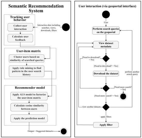
Figure 1


