Topic Editors

Dr. Shivanand Balram
Department of Geography (Faculty of Environment), Simon Fraser University, 8888 University Drive, Burnaby, BC V5A 1S6, Canada
Department of Geography and School of Environment, McGill University, 805 Sherbrooke St W., Montreal, QC H3A 0B9, Canada
Institute of Geography and Spatial Planning, Universidade de Lisboa, Lisbon, Portugal

Spatial Decision Support Systems for Urban Sustainability

Abstract submission deadline
30 August 2024
Manuscript submission deadline
31 October 2024
Viewed by
2259

Topic Information

Dear Colleagues,

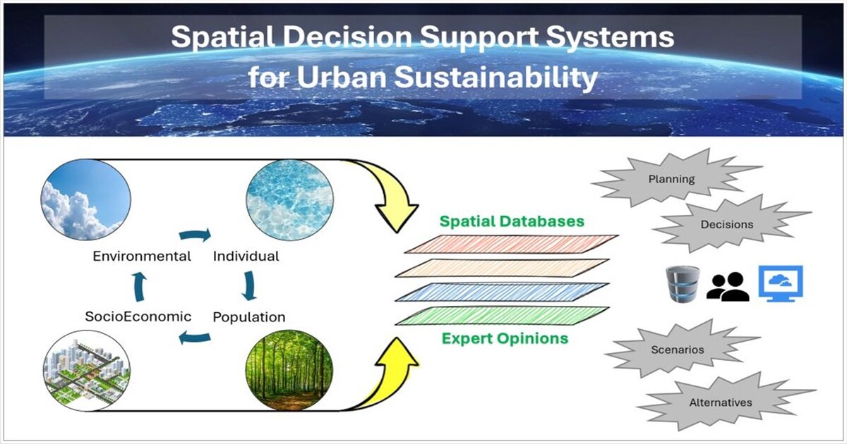
Spatial Decision Support Systems (SDSSs) are designed around geospatial data, models, and analytical tools that collectively support human planning and decision-making procedures in multiple application areas. These areas are constantly evolving to better address existing real-world challenges and find innovative ways forward such as in enabling and facilitating urban sustainability.

In this Topic Issue, we focus on the theory and methods of SDSSs and their implementation in the context of urban sustainability. We are interpreting sustainability broadly to mean the understanding and improvement of inputs and processes that optimize the distribution of output patterns. We welcome contributions from research directions that focus on data-oriented approaches (e.g., spatial multicriteria methods and remote sensing), intelligence-based approaches (e.g., machine learning and artificial intelligence methods), model-based approaches (e.g., analytics and simulation methods), and participatory approaches (e.g., citizen science and volunteer GIS methods). In addition, the interoperability between the data, systems, and people can yield innovative contributions. We anticipate these ideas will be developed around the pressing urban sustainability challenges that deal with land use and land cover change, climate change adaptation, and population growth, among others.

The topic "Spatial Decision Support Systems for Urban Sustainability” provides an outlet to publish original research and application papers. Join us as we re-examine existing pathways and explore new ground in the science and applications of SDSSs. We look forward to your contributions.

Dr. Shivanand Balram
Dr. Raja Sengupta
Dr. Jorge Rocha
Topic Editors

Keywords

  • Spatial Decision Support Systems (SDSS)
  • climate change adaptation
  • Geographic Information Systems (GIS)
  • land use planning
  • remote sensing
  • urban informatics
  • urban sustainability

Participating Journals

Journal Name Impact Factor CiteScore Launched Year First Decision (median) APC
Geographies
geographies
- 1.7 2021 23.5 Days CHF 1000 Submit
Geomatics
geomatics
- - 2021 21.8 Days CHF 1000 Submit
ISPRS International Journal of Geo-Information
ijgi
2.8 6.9 2012 36.2 Days CHF 1700 Submit
Land
land
3.2 4.9 2012 17.8 Days CHF 2600 Submit
Urban Science
urbansci
2.1 4.3 2017 24.7 Days CHF 1600 Submit
Sustainability
sustainability
3.3 6.8 2009 20 Days CHF 2400 Submit

Preprints.org is a multidiscipline platform providing preprint service that is dedicated to sharing your research from the start and empowering your research journey.

MDPI Topics is cooperating with Preprints.org and has built a direct connection between MDPI journals and Preprints.org. Authors are encouraged to enjoy the benefits by posting a preprint at Preprints.org prior to publication:

  1. Immediately share your ideas ahead of publication and establish your research priority;
  2. Protect your idea from being stolen with this time-stamped preprint article;
  3. Enhance the exposure and impact of your research;
  4. Receive feedback from your peers in advance;
  5. Have it indexed in Web of Science (Preprint Citation Index), Google Scholar, Crossref, SHARE, PrePubMed, Scilit and Europe PMC.

Published Papers (3 papers)

Order results
Result details
Journals
Select all
Export citation of selected articles as:
26 pages, 5896 KiB  
Article
Urban Parks in Novi Sad (Serbia)—Insights from Landscape Architecture Students
by Milena Lakićević, Nebojša Dedović, Marco Marto and Keith M. Reynolds
Urban Sci. 2024, 8(3), 99; https://doi.org/10.3390/urbansci8030099 - 26 Jul 2024
Abstract
Urban parks are vital components of city ecosystems, enhancing biodiversity, climate resilience, air and water quality, health, socialization, and economic benefits for citizens in urban areas. This paper examines urban parks in Novi Sad by gathering opinions on their qualities and functions through [...] Read more.
Urban parks are vital components of city ecosystems, enhancing biodiversity, climate resilience, air and water quality, health, socialization, and economic benefits for citizens in urban areas. This paper examines urban parks in Novi Sad by gathering opinions on their qualities and functions through a questionnaire. The respondents were students enrolled in the landscape architecture course at the University of Novi Sad. To analyze their responses, multivariate statistical analysis techniques, including ANOVA, MANOVA, and contingency tables, were applied. The results highlight the primary reasons for visiting urban parks in general, as well as specific parks in Novi Sad. The paper offers insights into visitor behavior, including the frequency and length of their stays, etc., and provides an assessment of the parks’ educational functions, which were expected to be highly relevant for the respondent group. The results can be relevant for further urban park development and serve as a starting point for applying multi-criteria (MC) analysis. Specifically, the results can be used to define a set of criteria, goals, and other essential elements necessary for conducting Analytic Hierarchy Processes or similar MC analysis methods. Full article
(This article belongs to the Topic Spatial Decision Support Systems for Urban Sustainability)
Show Figures

Figure 1

18 pages, 9889 KiB  
Article
Urban Planning with Rational Green Infrastructure Placement Using a Critical Area Detection Method
by Herath Mudiyanselage Malhamige Sonali Dinesha Herath, Takeshi Fujino and Mudalige Don Hiranya Jayasanka Senavirathna
Geomatics 2024, 4(3), 253-270; https://doi.org/10.3390/geomatics4030014 - 5 Jul 2024
Viewed by 369
Abstract
In an era of intense urban development and climate extremes, green infrastructure (GI) has become crucial for creating sustainable, livable, and resilient cities. However, the efficacy of GI is frequently undermined by haphazard implementation and resource misallocation that disregards appropriate spatial scales. This [...] Read more.
In an era of intense urban development and climate extremes, green infrastructure (GI) has become crucial for creating sustainable, livable, and resilient cities. However, the efficacy of GI is frequently undermined by haphazard implementation and resource misallocation that disregards appropriate spatial scales. This study develops a geographic information system (GIS)-based critical area detection model (CADM) to identify priority areas for the strategic placement of GI, incorporating four main indices—spatial form, green cover, gray cover, and land use change—and utilizing the digital elevation model (DEM), normalized difference vegetation index (NDVI), urban density index (UDI), and up-to-date land use data. By employing the developed method, the study successfully locates priority zones for GI implementation in Saitama City, Japan, effectively pinpointing areas that require immediate attention. This approach not only guarantees efficient resource allocation and maximizes the multifunctional benefits of GI but also highlights the importance of a flexible, all-encompassing GI network to address urbanization and environmental challenges. The findings offer policymakers a powerful tool with which to optimize GI placement, enhancing urban resilience and supporting sustainable development. Full article
(This article belongs to the Topic Spatial Decision Support Systems for Urban Sustainability)
Show Figures

Figure 1

24 pages, 5816 KiB  
Article
Spatial Nonlinear Effects of Street Vitality Constrained by Construction Intensity and Functional Diversity—A Case Study from the Streets of Shenzhen
by Jilong Li, Niuniu Kong, Shiping Lin, Jie Zeng, Yilin Ke and Jiacheng Chen
ISPRS Int. J. Geo-Inf. 2024, 13(7), 238; https://doi.org/10.3390/ijgi13070238 - 2 Jul 2024
Viewed by 571
Abstract
As an important part of urban vitality, street vitality is an external manifestation of street economic prosperity and is affected by the built environment and the surrounding street vitality. However, existing research on the formation mechanism of street vitality focuses only on the [...] Read more.
As an important part of urban vitality, street vitality is an external manifestation of street economic prosperity and is affected by the built environment and the surrounding street vitality. However, existing research on the formation mechanism of street vitality focuses only on the built environment itself, ignoring the spatial spillover effect on street vitality. This study uses 5290 street segments in Shenzhen as examples. Utilizing geospatial and other multisource big data, this study creates spatial weight matrices at varying distances based on different living circle ranges. By combining the panel threshold model (PTM) and the spatial panel Durbin model (SPDM), this study constructs a spatial autoregressive threshold model to explore the spatial nonlinear effects of street vitality, considering various spatial weight matrices and thresholds of construction intensity and functional diversity. Our results show the following: (1) Street vitality exhibits significant spatial spillover effects, which gradually weaken as the living circle range expands (Moran indices are 0.178***, 0.160***, and 0.145*** for the 500 m, 1000 m, and 1500 m spatial weight matrices, respectively). (2) Construction intensity has a threshold, which is 0.1466 under spatial matrices of different distances. Functional diversity has two thresholds: 0.6832 and 2.2065 for the 500 m spatial weight matrix, and 0.6832 and 1.4325 for the 1000 m matrices, and 0.6832 and 1.2724 for 1500 m matrices. (3) As an international metropolis, street accessibility in Shenzhen has a significant and strong positive impact on its street vitality. This conclusion provides stakeholders with spatial patterns that influence street vitality, offering a theoretical foundation to further break down barriers to street vitality. Full article
(This article belongs to the Topic Spatial Decision Support Systems for Urban Sustainability)
Show Figures

Figure 1

Back to TopTop