Next Issue
Volume 15, August
Previous Issue
Volume 15, June


Geosciences, Volume 15, Issue 7 (July 2025) – 41 articles

Cover Story (view full-size image): 
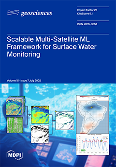
Estimating surface water volume (SWV) in the Amazon is difficult due to persistent cloud cover and dense canopy. However, because the region experiences some of the largest yearly surface water fluctuations, it is an important site to monitor for change. We address this challenge through the development of a machine learning framework integrating space-based multimodal observations (ICESat-2 lidar, Sentinel-1 SAR, and Sentinel-2 imagery) and airborne lidar for improved SWV estimation. Our two-stage approach enhances DEM accuracy by 66% and up to 79% with airborne data. SAR-based water detection enables all-weather monitoring (F1-score: 0.81). Validation with reservoir records shows strong correlations (0.63–0.97), capturing realistic temporal variations. This scalable method supports water monitoring in data-scarce regions. View this paper
  • Issues are regarded as officially published after their release is announced to the table of contents alert mailing list.
  • You may sign up for e-mail alerts to receive table of contents of newly released issues.
  • PDF is the official format for papers published in both, html and pdf forms. To view the papers in pdf format, click on the "PDF Full-text" link, and use the free Adobe Reader to open them.
Order results
Result details
Section
Select all
Export citation of selected articles as:
20 pages, 5671 KiB  
Article
Evaluation of Proppant Placement Efficiency in Linearly Tapering Fractures
by Xiaofeng Sun, Liang Tao, Jinxin Bao, Jingyu Qu, Haonan Yang and Shangkong Yao
Geosciences 2025, 15(7), 275; https://doi.org/10.3390/geosciences15070275 - 21 Jul 2025
Viewed by 158
Abstract
With growing reliance on hydraulic fracturing to develop tight oil and gas reservoirs characterized by low porosity and permeability, optimizing proppant transport and placement has become critical to sustaining fracture conductivity and production. However, how fracture geometry influences proppant distribution under varying field [...] Read more.
With growing reliance on hydraulic fracturing to develop tight oil and gas reservoirs characterized by low porosity and permeability, optimizing proppant transport and placement has become critical to sustaining fracture conductivity and production. However, how fracture geometry influences proppant distribution under varying field conditions remains insufficiently understood. This study employed computational fluid dynamics to investigate proppant transport and placement in hydraulic fractures of which the aperture tapers linearly along their length. Four taper rate models (δ = 0, 1/1500, 1/750, and 1/500) were analyzed under a range of operational parameters: injection velocities (1.38–3.24 m/s), sand concentrations (2–8%), proppant particle sizes (0.21–0.85 mm), and proppant densities (1760–3200 kg/m3). Equilibrium proppant pack height was adopted as the key metric for pack morphology. The results show that increasing injection rate and taper rate both serve to lower pack heights and enhance downstream transport, while a higher sand concentration, larger particle size, and greater density tend to raise pack heights and promote more stable pack geometries. In tapering fractures, higher δ values amplify flow acceleration and turbulence, yielding flatter, “table-top” proppant distributions and extended placement lengths. Fine, low-density proppants more readily penetrate to the fracture tip, whereas coarse or dense particles form taller inlet packs but can still be carried farther under high taper conditions. These findings offer quantitative guidance for optimizing fracture geometry, injection parameters, and proppant design to improve conductivity and reduce sand-plugging risk in tight formations. These insights address the challenge of achieving effective proppant placement in complex fractures and provide quantitative guidance for tailoring fracture geometry, injection parameters, and proppant properties to improve conductivity and mitigate sand plugging risks in tight formations. Full article
Show Figures

Figure 1

19 pages, 3099 KiB  
Article
Optimizing Geophysical Inversion: Versatile Regularization and Prior Integration Strategies for Electrical and Seismic Tomographic Data
by Guido Penta de Peppo, Michele Cercato and Giorgio De Donno
Geosciences 2025, 15(7), 274; https://doi.org/10.3390/geosciences15070274 - 20 Jul 2025
Viewed by 308
Abstract
The increasing demand for high-resolution subsurface imaging has driven significant advances in geophysical inversion methodologies. Despite the availability of various software packages for electrical resistivity tomography (ERT), time-domain induced polarization (TDIP), and seismic refraction tomography (SRT), significant challenges remain in selecting optimal regularization [...] Read more.
The increasing demand for high-resolution subsurface imaging has driven significant advances in geophysical inversion methodologies. Despite the availability of various software packages for electrical resistivity tomography (ERT), time-domain induced polarization (TDIP), and seismic refraction tomography (SRT), significant challenges remain in selecting optimal regularization parameters and in the effective incorporation of prior information into the inversion process. In this study, we propose new strategies to address these critical issues by developing versatile and flexible tools for electrical and seismic tomographic data inversion. Specifically, we introduce two automated procedures for regularization parameter selection: a full loop method (fixed-λ optimization) where the regularization parameter is kept constant during the inversion process, and a single-inversion approach (automaticLam) where it varies throughout the iterations. Additionally, we present a novel constrained inversion strategy that effectively balances prior information, minimizes data misfit, and promotes model smoothness. This approach is thoroughly compared with the state-of-the-art methods, demonstrating its superiority in maintaining model reliability and reducing dependence on subjective operator choices. Applications to synthetic, laboratory, and real-world case studies validate the efficacy of our strategies, showcasing their potential to enhance the robustness of geophysical models and standardize the inversion process, ensuring its independence from operator decisions. Full article
(This article belongs to the Special Issue Geophysical Inversion)
Show Figures

Figure 1

16 pages, 855 KiB  
Article
Evaluating Time Series Models for Monthly Rainfall Forecasting in Arid Regions: Insights from Tamanghasset (1953–2021), Southern Algeria
by Ballah Abderrahmane, Morad Chahid, Mourad Aqnouy, Adam M. Milewski and Benaabidate Lahcen
Geosciences 2025, 15(7), 273; https://doi.org/10.3390/geosciences15070273 - 20 Jul 2025
Viewed by 264
Abstract
Accurate precipitation forecasting remains a critical challenge due to the nonlinear and multifactorial nature of rainfall dynamics. This is particularly important in arid regions like Tamanghasset, where precipitation is the primary driver of agricultural viability and water resource management. This study evaluates the [...] Read more.
Accurate precipitation forecasting remains a critical challenge due to the nonlinear and multifactorial nature of rainfall dynamics. This is particularly important in arid regions like Tamanghasset, where precipitation is the primary driver of agricultural viability and water resource management. This study evaluates the performance of several time series models for monthly rainfall prediction, including the autoregressive integrated moving average (ARIMA), Exponential Smoothing State Space Model (ETS), Seasonal and Trend decomposition using Loess with ETS (STL-ETS), Trigonometric Box–Cox transform with ARMA errors, Trend and Seasonal components (TBATS), and neural network autoregressive (NNAR) models. Historical monthly precipitation data from 1953 to 2020 were used to train and test the models, with lagged observations serving as input features. Among the approaches considered, the NNAR model exhibited superior performance, as indicated by uncorrelated residuals and enhanced forecast accuracy. This suggests that NNAR effectively captures the nonlinear temporal patterns inherent in the precipitation series. Based on the best-performing model, rainfall was projected for the year 2021, providing actionable insights for regional hydrological and agricultural planning. The results highlight the relevance of neural network-based time series models for climate forecasting in data-scarce, climate-sensitive regions. Full article
(This article belongs to the Section Climate and Environment)
Show Figures

Figure 1

25 pages, 5096 KiB  
Article
Scenario Analysis in Intensively Irrigated Semi-Arid Watershed Using a Modified SWAT Model
by Pratikshya Neupane and Ryan T. Bailey
Geosciences 2025, 15(7), 272; https://doi.org/10.3390/geosciences15070272 - 20 Jul 2025
Viewed by 239
Abstract
Intensive irrigation in arid and semi-arid regions can cause significant environmental issues, including salinity, waterlogging, and water quality deterioration. Watershed modeling helps us understand essential water balance components in these areas. This study implemented a modified SWAT (Soil and Water Assessment Tool) model [...] Read more.
Intensive irrigation in arid and semi-arid regions can cause significant environmental issues, including salinity, waterlogging, and water quality deterioration. Watershed modeling helps us understand essential water balance components in these areas. This study implemented a modified SWAT (Soil and Water Assessment Tool) model tailored to capture irrigation practices within a 15,900 km2 area of the Arkansas River Basin from 1990 to 2014. The model analyzed key water balance elements: surface runoff, evapotranspiration, soil moisture, lateral flow, and groundwater return flow, distinguishing between wet and dry years. Over 90% of precipitation is consumed by evapotranspiration. The average watershed water yield comprises 19% surface runoff, 39% groundwater return flow, and 42% lateral flow. Various irrigation scenarios were simulated, revealing that transitioning from flood to sprinkler irrigation reduced surface runoff by over 90% without affecting crop water availability in the intensively irrigated region of the watershed. Canal sealing scenarios showed substantial groundwater return flow reductions: approximately 15% with 20% sealing and around 57% with 80% sealing. Scenario-based analyses like these provide valuable insights for optimizing water resource management in intensively irrigated watersheds. Full article
(This article belongs to the Section Hydrogeology)
Show Figures

Figure 1

24 pages, 2050 KiB  
Article
Geomorphological Mapping and Social Sciences: A Qualitative Review
by Laura Franceschi, Alberto Bosino, Manuel La Licata and Mattia De Amicis
Geosciences 2025, 15(7), 271; https://doi.org/10.3390/geosciences15070271 - 18 Jul 2025
Viewed by 385
Abstract
The number of publications in the scientific literature dealing with geomorphological mapping has increased over the last two decades. Although geomorphological maps are utilised in various contexts, such as hazard assessment, archaeology, and tourism, there is a noticeable lack of interaction between geomorphological [...] Read more.
The number of publications in the scientific literature dealing with geomorphological mapping has increased over the last two decades. Although geomorphological maps are utilised in various contexts, such as hazard assessment, archaeology, and tourism, there is a noticeable lack of interaction between geomorphological products and the social sciences. This study aims to provide a qualitative assessment of the literature on geomorphological maps published in the 2000s with the intent of identifying the purpose of mapping and its field of application. Additionally, a comparative analysis was conducted of the articles relating to both geomorphological maps and social issues to identify the tools that facilitate this interdisciplinary collaboration. The results facilitated the identification of the primary fields of interest for map production, showing that only a limited number of articles employed geomorphological maps for social purposes, for instance, enhancing risk awareness and educating the population about natural hazards. Moreover, the analysis reveals that only a limited number of geomorphological maps are intended to be accessible to people without a high degree of education in earth sciences. In particular, this study highlights a lack of attention to non-specialist users who may struggle to understand the information contained in geomorphological maps. This issue limits the dissemination of geomorphological maps, which are, however, vital for territorial planning and practical purposes. The analyses prompted the authors to consider novel applications of research tools to enhance the dissemination of geomorphological maps, even among non-specialist users. Full article
Show Figures

Figure 1

19 pages, 2394 KiB  
Article
The Geotourism Product—What It Is and What It Is Not
by Ľubomír Štrba, Silvia Bodzáš Palgutová, Ján Derco, Branislav Kršák and Csaba Sidor
Geosciences 2025, 15(7), 270; https://doi.org/10.3390/geosciences15070270 - 12 Jul 2025
Viewed by 358
Abstract
The worldwide expansion of geotourism and its ongoing development have captured the interest of numerous scholars, prompting them to investigate various theoretical dimensions within this emerging field. This paper explores the concept of geotourism products and the importance of comprehensively understanding this topic. [...] Read more.
The worldwide expansion of geotourism and its ongoing development have captured the interest of numerous scholars, prompting them to investigate various theoretical dimensions within this emerging field. This paper explores the concept of geotourism products and the importance of comprehensively understanding this topic. A thorough review of the existing literature indicates that different researchers offer diverse definitions and interpretations of geotourism products. However, analysis of relevant publications reveals that these perspectives do not adequately incorporate the fundamental principles of geotourism alongside the well-defined and broadly accepted concept of tourism products in general. To facilitate the accurate analysis of research outcomes and to support the effective advancement of geotourism, this paper advocates for a clear and well-defined understanding of what constitutes a geotourism product. Full article
Show Figures

Figure 1

19 pages, 2647 KiB  
Article
Geological, Mineralogical, and Alteration Insights of the Intermediate-Sulfidation Epithermal Mineralization in the Sidi Aissa District, Northern Tunisia
by Jamel Ayari, Maurizio Barbieri, Tiziano Boschetti, Ahmed Sellami, Paolo Ballirano and Abdelkarim Charef
Geosciences 2025, 15(7), 269; https://doi.org/10.3390/geosciences15070269 - 12 Jul 2025
Viewed by 422
Abstract
The Sidi Aissa Pb-Zn-(Ag) District, located within the Nappe Zone of northern Tunisia, has been reinterpreted as a typical intermediate-sulfidation (IS) epithermal mineralization system based on field observations and lithogeochemical analyses. Previously described as vein-style Pb-Zn deposits, the local geological framework is dominated [...] Read more.
The Sidi Aissa Pb-Zn-(Ag) District, located within the Nappe Zone of northern Tunisia, has been reinterpreted as a typical intermediate-sulfidation (IS) epithermal mineralization system based on field observations and lithogeochemical analyses. Previously described as vein-style Pb-Zn deposits, the local geological framework is dominated by extensional normal faults forming half-grabens. These faults facilitated the exhumation of deep Triassic autochthonous rocks and the extrusion of 8-Ma rhyodacites and Messinian basalts. These structures, functioning as pathways for magmatic-hydrothermal fluids, facilitated the upward migration of acidic fluids, which interacted with the surrounding wall rocks, forming a subsurface alteration zone. The mineralization, shaped by Miocene extensional tectonics and magmatic activity, occurred in three stages: early quartz-dominated veins, an intermediate barite-rich phase, and late-stage supergene oxidation. Hydrothermal alteration, characterized by silicification, argillic, and propylitic zones, is closely associated with the deposition of base metals (Pb, Zn) and silver. The mineral assemblage, including barite, galena, sphalerite, and quartz, reflects dynamic processes such as fluid boiling, mixing, and pressure changes. Full article
(This article belongs to the Section Geochemistry)
Show Figures

Figure 1

25 pages, 6820 KiB  
Article
Coccolithophore Assemblage Dynamics and Emiliania huxleyi Morphological Patterns During Three Sampling Campaigns Between 2017 and 2019 in the South Aegean Sea (Greece, NE Mediterranean)
by Patrick James F. Penales, Elisavet Skampa, Margarita D. Dimiza, Constantine Parinos, Dimitris Velaoras, Alexandra Pavlidou, Elisa Malinverno, Alexandra Gogou and Maria V. Triantaphyllou
Geosciences 2025, 15(7), 268; https://doi.org/10.3390/geosciences15070268 - 11 Jul 2025
Viewed by 620
Abstract
This study presents the living coccolithophore communities and the morphological variability of Emiliania huxleyi in the South Aegean Sea from three sampling regions during winter-early spring (March 2017, March 2019) and summer (August 2019). Emphasis is given to March 2017 to monitor the [...] Read more.
This study presents the living coccolithophore communities and the morphological variability of Emiliania huxleyi in the South Aegean Sea from three sampling regions during winter-early spring (March 2017, March 2019) and summer (August 2019). Emphasis is given to March 2017 to monitor the variations in coccolithophore assemblages after an exceptionally cold event in December 2016, which resulted in newly produced dense waters that ventilated the Aegean deep basins. The assemblages displayed distinct seasonality with the predominance of E. huxleyi and Syracosphaera molischii during winter-early spring, associated with the water column mixing. By contrast, summer assemblages were featured by holococcolithophores and typical taxa of warm, oligotrophic upper waters. It seems that the phytoplanktonic succession as well as the nutrient supply to the upper euphotic layers were affected by the water column perturbation during the extreme winter of 2016–2017, which led to strong convective mixing and dense water formation. The decreased coccosphere densities during March 2017, accompanied by the notable presence of diatoms, were most probably associated with a prolonged diatom bloom, causing delay in the development of the coccolithophore community and resulting in a nitrogen-limited setting. Emiliania huxleyi morphometry showed the characteristic seasonal calcification trend of the Aegean, with the dominance of smaller coccoliths in the summer and increased coccolith length and width during the cold season. The intense cold conditions and wind-induced mixing during the winter of 2016–2017 possibly increased the absorption of atmospheric CO2 in surface waters, causing increased acidity and the subsequent presence of etched/undercalcified E. huxleyi coccoliths and other taxa, most probably implying in situ calcite dissolution. Full article
(This article belongs to the Section Biogeosciences)
Show Figures

Figure 1

21 pages, 7866 KiB  
Article
Asteroid and Meteorite Impacts as a Cause of Large Sedimentary Basins: A Case Study of the Transylvanian Depression
by Dumitru Ioane, Irina Stanciu and Mihaela Scradeanu
Geosciences 2025, 15(7), 267; https://doi.org/10.3390/geosciences15070267 - 9 Jul 2025
Viewed by 666
Abstract
Impact cratering determined by collisions with meteorites and asteroids is considered one of the main natural processes in the Solar System, modifying the planets and their satellites surface during time. The Earth includes in its impact record a small number of such events [...] Read more.
Impact cratering determined by collisions with meteorites and asteroids is considered one of the main natural processes in the Solar System, modifying the planets and their satellites surface during time. The Earth includes in its impact record a small number of such events due to active plate tectonics, sedimentation, and volcanism, with these geological processes destroying and burying their impact geomorphological signatures. To enlarge the Earth’s impacts database, new concepts and research methods are necessary, as well as the reinterpretation of old geological and geophysical models. Geomorphological, Geological, and Geophysical (3G) signatures in concealed impacted areas are discussed in this paper; the first offers the target characteristics, while the others give means for detecting their unseen remnants. The 3G signatures have been applied to the Transylvanian Depression, a fascinating geological structure, with difficulties in explaining the direct overlapping of regionally developed thick tuff and thick salt layers, and undecided interpretation of the regional magnetic anomaly. Large and deep sedimentary basins, such as the Precaspian, Alexandria and Transylvanian depressions, are interpreted to have started as impacted areas during the Permian or the Lower Neogene. Geophysical and geological existing information have been reinterpreted, offering a new way in understanding deeply located geological structures. Full article
Show Figures

Figure 1

26 pages, 3270 KiB  
Review
Carbon Isotopes in Magmatic Systems: Measurements, Interpretations, and the Carbon Isotopic Signature of the Earth’s Mantle
by Yves Moussallam
Geosciences 2025, 15(7), 266; https://doi.org/10.3390/geosciences15070266 - 9 Jul 2025
Viewed by 306
Abstract
Carbon isotopes in magmatic systems serve as powerful tracers for understanding magma evolution, mantle processes, the deep carbon cycle, and the origin of Earth’s carbon. This review provides a comprehensive overview of carbon isotope measurements and behavior in magmatic systems, highlighting recent technological [...] Read more.
Carbon isotopes in magmatic systems serve as powerful tracers for understanding magma evolution, mantle processes, the deep carbon cycle, and the origin of Earth’s carbon. This review provides a comprehensive overview of carbon isotope measurements and behavior in magmatic systems, highlighting recent technological advancements and scientific insights. We begin by examining methods for measuring δ13C in volcanic gases, vesicles, glasses, melt, and fluid inclusions. We then explore the behavior of carbon isotopes in magmatic systems, especially during magmatic degassing. Finally, we evaluate what recent advances mean for our understanding of the carbon isotope signature of the Earth’s upper mantle. Full article
Show Figures

Figure 1

19 pages, 2353 KiB  
Article
A Novel Bimodal Hydro-Mechanical Coupling Model for Evaluating Rainfall-Induced Unsaturated Slope Stability
by Tzu-Hao Huang, Ya-Sin Yang and Hsin-Fu Yeh
Geosciences 2025, 15(7), 265; https://doi.org/10.3390/geosciences15070265 - 9 Jul 2025
Viewed by 235
Abstract
The soil water characteristic curve (SWCC) is a key foundation in unsaturated soil mechanics describing the relationship between matric suction and water content, which is crucial for studies on effective stress, permeability coefficients, and other soil properties. In natural environments, colluvial and residual [...] Read more.
The soil water characteristic curve (SWCC) is a key foundation in unsaturated soil mechanics describing the relationship between matric suction and water content, which is crucial for studies on effective stress, permeability coefficients, and other soil properties. In natural environments, colluvial and residual soils typically exhibit high pore heterogeneity, and previous studies have shown that the SWCC is closely related to the distribution of pore sizes. The SWCC of soils may display either a unimodal or bimodal distribution, leading to different hydraulic behaviors. Past unsaturated slope stability analyses have used the unimodal SWCC model, but this assumption may result in evaluation errors, affecting the accuracy of seepage and slope stability analyses. This study proposes a novel bimodal hydro-mechanical coupling model to investigate the influence of bimodal SWCC representations on rainfall-induced seepage behavior and stability of unsaturated slopes. By fitting the unimodal and bimodal SWCCs with experimental data, the results show that the bimodal model provides a higher degree of fit and smaller errors, offering a more accurate description of the relationship between matric suction and effective saturation, thus improving the accuracy of soil hydraulic property assessment. Furthermore, the study established a hypothetical slope model and used field data of landslides to simulate the collapse of Babaoliao in Chiayi County, Taiwan. The results show that the bimodal model predicts slope instability 1 to 3 h earlier than the unimodal model, with the rate of change in the safety factor being about 16.6% to 25.1% higher. The research results indicate the superiority of the bimodal model in soils with dual-porosity structures. The bimodal model can improve the accuracy and reliability of slope stability assessments. Full article
Show Figures

Figure 1

25 pages, 9560 KiB  
Article
I.S.G.E.: An Integrated Spatial Geotechnical and Geophysical Evaluation Methodology for Subsurface Investigations
by Christos Orfanos, Konstantinos Leontarakis, George Apostolopoulos, Ioannis E. Zevgolis and Bojan Brodic
Geosciences 2025, 15(7), 264; https://doi.org/10.3390/geosciences15070264 - 8 Jul 2025
Viewed by 223
Abstract
A new Integrated Spatial Geophysical and Geotechnical Evaluation (I.S.G.E) methodology has been developed to estimate the spatial distribution of geotechnical parameters using high-resolution geophysical methods. The proposed algorithm is based on fuzzy logic, and the final output is the prediction of the 2D [...] Read more.
A new Integrated Spatial Geophysical and Geotechnical Evaluation (I.S.G.E) methodology has been developed to estimate the spatial distribution of geotechnical parameters using high-resolution geophysical methods. The proposed algorithm is based on fuzzy logic, and the final output is the prediction of the 2D or 3D distribution of a geotechnical parameter within a survey area. The main advantage of the developed I.S.G.E tool is that it can propagate sparse geotechnical or point information from 1D to 2D or even 3D space through a fully automatic, unbiased statistical procedure. In this study, I.S.G.E. is implemented and evaluated first using synthetic data and, afterwards, in field condition applications. The automatically derived 3D models, depicting the spatial distribution of specific geotechnical parameters, provide engineers with an additional interpretation tool for better understanding the subsurface conditions of a survey area. Full article
(This article belongs to the Section Geophysics)
Show Figures

Figure 1

18 pages, 5336 KiB  
Article
Comparative Flexural Response of Mineralized Massive Sulfides and Meta-Rhyolitic Rocks
by Haitham M. Ahmed and Essam B. Moustafa
Geosciences 2025, 15(7), 263; https://doi.org/10.3390/geosciences15070263 - 8 Jul 2025
Viewed by 220
Abstract
An experimental study was conducted to investigate the flexural mechanical properties of mineralized (massive sulfides) and non-mineralized (meta-rhyolitic tuff) rock samples using a three-point bending test. Mineralogical analysis was conducted on samples from both rock categories, followed by the determination of physical properties [...] Read more.
An experimental study was conducted to investigate the flexural mechanical properties of mineralized (massive sulfides) and non-mineralized (meta-rhyolitic tuff) rock samples using a three-point bending test. Mineralogical analysis was conducted on samples from both rock categories, followed by the determination of physical properties (P-wave velocity and density). In the massive sulfide zones, there are three distinctive zones of mineralization, each exhibiting varying degrees of pyritization: the intense pyritization zone (formerly Zone A) exhibited extensive pyrite replacement of sphalerite and chalcopyrite, the transitional zone (Zone B) displays intergrowths of pyrite and sphalerite, and the coarse sulfide zone (Zone C) features coarser, less altered sulfides—polyphase hydrothermal alteration, including sericitization, silicification, and amphibole veining. Mineralized rocks showed a 35.18% increase in density (3.65 ± 0.17 kg/m3 vs. 2.72 ± 0.014 kg/m3) attributed to dense sulfide content. The flexural strength more than doubled (99.02 ± 4.42 GPa vs. 43.17 ± 6.45 GPa), experiencing a 129% increase, due to homogeneous chalcopyrite distribution and fine-grained sulfide networks. Despite strength differences, deflection rates showed a non-significant 4% variation (0.373 ± 0.083 mm for mineralized vs. 0.389 ± 0.074 mm for metamorphic rocks), indicating comparable ductility. Full article
Show Figures

Figure 1

16 pages, 1176 KiB  
Article
Vertebrate Skeletal Remains as Paleohydrologic Proxies: Complex Hydrologic Setting in the Upper Cretaceous Kaiparowits Formation
by Daigo Yamamura and Celina Suarez
Geosciences 2025, 15(7), 262; https://doi.org/10.3390/geosciences15070262 - 8 Jul 2025
Viewed by 759
Abstract
The Kaiparowits Formation preserves one of the best fossil records of Cretaceous North America, which provides great insight into the paleoecology. In an effort to investigate the paleohydrology of the Kaiparowits Formation, stable isotope compositions (δ13C, δ18O-carbonate, δ18 [...] Read more.
The Kaiparowits Formation preserves one of the best fossil records of Cretaceous North America, which provides great insight into the paleoecology. In an effort to investigate the paleohydrology of the Kaiparowits Formation, stable isotope compositions (δ13C, δ18O-carbonate, δ18O-phosphate) of 41 hadrosaur teeth, 27 crocodile teeth, and 35 turtle shell fragments were analyzed. The mean O-isotope compositions of drinking water (δ18Ow) calculated from the O-isotope of bioapatite (phosphate-δ18Op) are −13.76 ± 2.08‰ (SMOW) for hadrosaur, −8.88 ± 2.76‰ (SMOW) for crocodile, and −10.14 ± 2.62‰ (SMOW) for turtle, which strongly reflect niche partitioning. The Kaiparowits formation does not fit the global trend in isotopic compositions of vertebrate skeletal remains from previous studies, which suggests a unique hydrological setting of the Kaiparowits basin. High-elevation runoff from the Mogollon Highlands and sea level fluctuation may have contributed to such a unique paleohydrology. Full article
(This article belongs to the Section Sedimentology, Stratigraphy and Palaeontology)
Show Figures

Figure 1

21 pages, 2362 KiB  
Article
Stabilization of Expansive Clay Using Volcanic Ash
by Svetlana Melentijević, Aitor López Marcos, Roberto Ponce and Sol López-Andrés
Geosciences 2025, 15(7), 261; https://doi.org/10.3390/geosciences15070261 - 8 Jul 2025
Cited by 2 | Viewed by 343
Abstract
Considering the increasing requirements for the recovery of different natural and industrial waste materials, the application of volcanic ash as an alternative sustainable binder to traditionally employed lime and cement is proposed for soil stabilization for geotechnical engineering purposes, thus providing a reduction [...] Read more.
Considering the increasing requirements for the recovery of different natural and industrial waste materials, the application of volcanic ash as an alternative sustainable binder to traditionally employed lime and cement is proposed for soil stabilization for geotechnical engineering purposes, thus providing a reduction in carbon emissions. Soil stabilization was performed on natural clays with very high swelling potential, i.e. those classified as inadequate for reuse as a building material for geotechnical purposes. A mineralogical and chemical characterization of raw materials was carried out prior to the performance of different geotechnical laboratory tests, i.e., testing Atterberg limits, compaction, swelling potential, compressibility and resistance parameters over naturally remolded clay and soil mixtures with different binders. The swelling potential was reduced with an increase in the amount of applied binder, necessitating the addition of 10, 20, and 30% of volcanic ash compared to 3% lime, 3% cement and 5% lime, respectively, for a similar reduction in swelling potential. An investigation of the resistance parameters for soil mixture specimens that provided a suitable reduction in swelling potential for their reuse was performed, and a comparison to the parameters of naturally remolded clay was made. Full article
(This article belongs to the Section Geomechanics)
Show Figures

Figure 1

9 pages, 1772 KiB  
Article
Cliff-Front Dune Development During the Late Pleistocene at Sa Fortalesa (Mallorca, Western Mediterranean)
by Laura del Valle, Federica Perazzotti and Joan J. Fornós
Geosciences 2025, 15(7), 260; https://doi.org/10.3390/geosciences15070260 - 5 Jul 2025
Viewed by 274
Abstract
This study presents the first detailed analysis of a Late Pleistocene cliff-front dune in northern Mallorca (Western Mediterranean). The research is based on sedimentological fieldwork conducted in a disused coastal quarry, where stratigraphic columns were recorded and facies were described in detail. Grain [...] Read more.
This study presents the first detailed analysis of a Late Pleistocene cliff-front dune in northern Mallorca (Western Mediterranean). The research is based on sedimentological fieldwork conducted in a disused coastal quarry, where stratigraphic columns were recorded and facies were described in detail. Grain size analysis was performed using image-based measurements from representative samples, and palaeowind conditions were reconstructed through the analysis of cross-bedding orientations and empirical wind transport equations. The dune, corresponding to Unit U4, exhibits three distinct evolutionary stages: initial, intermediate, and final. During the initial stage, sediment mobilisation required wind speeds of approximately 10 m/s from the south-southwest (SSW). The intermediate stage was characterised by variable wind velocities between 5 and 8 m/s from the west-southwest (WSW). In the final stage, average wind speeds reached 7 m/s from the west (W), with intermittent peaks up to 10 m/s. These findings underscore the critical influence of wind regime and topographic constraints on aeolian sedimentation processes. By reconstructing wind dynamics and analysing sedimentary architecture, this work provides key insights into the interplay between climatic drivers and geological context in the development of coastal aeolian systems. Full article
(This article belongs to the Section Sedimentology, Stratigraphy and Palaeontology)
Show Figures

Figure 1

26 pages, 35238 KiB  
Article
Sediment Connectivity in Human-Impacted vs. Natural Conditions: A Case Study in a Landslide-Affected Catchment
by Mohanad Ellaithy, Davide Notti, Daniele Giordan, Marco Baldo, Jad Ghantous, Vincenzo Di Pietra, Marco Cavalli and Stefano Crema
Geosciences 2025, 15(7), 259; https://doi.org/10.3390/geosciences15070259 - 5 Jul 2025
Viewed by 392
Abstract
This research aims to characterize sediment dynamics in the Rupinaro catchment, a uniquely terraced and human-shaped basin in Italy’s Liguria region, employing geomorphometric methods to unravel sediment connectivity in a landscape vulnerable to shallow landslides. Within a scenario-based approach, we utilized high-resolution LiDAR-derived [...] Read more.
This research aims to characterize sediment dynamics in the Rupinaro catchment, a uniquely terraced and human-shaped basin in Italy’s Liguria region, employing geomorphometric methods to unravel sediment connectivity in a landscape vulnerable to shallow landslides. Within a scenario-based approach, we utilized high-resolution LiDAR-derived digital terrain models (DTMs) to calculate the Connectivity Index, comparing sediment dynamics between the original terraced landscape and a virtual natural scenario. To reconstruct a pristine slope morphology, we applied a topographic roughness-based skeletonization algorithm that simplifies terraces into linear features to simulate natural hillslope conditions and remove anthropogenic structures. The analysis was carried out considering diverse targets (e.g., hydrographic networks, road networks) and the effect of land use. The results reveal significant differences in sediment connectivity between the anthropogenic and natural morphologies, with implications for erosion and landslide susceptibility. The findings reveal that sediment connectivity is moderately higher in the scenario without terraces, indicating that terraces function as effective barriers to sediment transfer. This highlights their potential role in mitigating landslide susceptibility on steep slopes. Additionally, the results show that roads exert a stronger influence on the Connectivity Index, significantly altering flow paths. These modifications appear to contribute to increased landslide susceptibility in adjacent areas, as reflected by the higher observed landslide density within the study region. Full article
(This article belongs to the Section Natural Hazards)
Show Figures

Figure 1

19 pages, 4273 KiB  
Article
Improved Dynamic Correction for Seismic Data Processing: Mitigating the Stretch Effect in NMO Correction
by Pedro Cortes-Guerrero, Carlos Ortiz-Alemán, Jaime Urrutia-Fucugauchi, Sebastian Lopez-Juarez, Mauricio Gabriel Orozco-del Castillo and Mauricio Nava-Flores
Geosciences 2025, 15(7), 258; https://doi.org/10.3390/geosciences15070258 - 5 Jul 2025
Viewed by 302
Abstract
Seismic data processing is essential in hydrocarbon exploration, with normal moveout (NMO) correction being a pivotal step in enhancing seismic signal quality. However, conventional NMO correction often suffers from the stretch effect, which distorts seismic reflections and degrades data quality, especially in long-offset [...] Read more.
Seismic data processing is essential in hydrocarbon exploration, with normal moveout (NMO) correction being a pivotal step in enhancing seismic signal quality. However, conventional NMO correction often suffers from the stretch effect, which distorts seismic reflections and degrades data quality, especially in long-offset data. This study addresses the issue by analyzing synthetic models and proposing a nonhyperbolic stretch-free NMO correction technique. The proposed method significantly improves seismic data quality by preserving up to 90% of the original amplitude, maintaining frequency content stability at 30 Hz, and achieving a high reduction of stretch-related distortions. Compared to conventional NMO, our technique results in clearer seismic gathers, enhanced temporal resolution, and more accurate velocity models. These improvements have substantial implications for high-resolution subsurface imaging and precise reservoir characterization.This work offers a robust and computationally efficient solution to a longstanding limitation in seismic processing, advancing the reliability of exploration in geologically complex environments. Full article
(This article belongs to the Section Geophysics)
Show Figures

Figure 1

22 pages, 16710 KiB  
Article
Carbonate Seismic Facies Analysis in Reservoir Characterization: A Machine Learning Approach with Integration of Reservoir Mineralogy and Porosity
by Papa Owusu, Abdelmoneam Raef and Essam Sharaf
Geosciences 2025, 15(7), 257; https://doi.org/10.3390/geosciences15070257 - 4 Jul 2025
Viewed by 358
Abstract
Amid increasing interest in enhanced oil recovery and carbon geological sequestration programs, improved static reservoir lithofacies models are emerging as a requirement for well-guided project management. Building reservoir models can leverage seismic attribute clustering for seismic facies mapping. One challenge is that machine [...] Read more.
Amid increasing interest in enhanced oil recovery and carbon geological sequestration programs, improved static reservoir lithofacies models are emerging as a requirement for well-guided project management. Building reservoir models can leverage seismic attribute clustering for seismic facies mapping. One challenge is that machine learning (ML) seismic facies mapping is prone to a wide range of equally possible outcomes when traditional unsupervised ML classification is used. There is a need to constrain ML seismic facies outcomes to limit the predicted seismic facies to those that meet the requirements of geological plausibility for a given depositional setting. To this end, this study utilizes an unsupervised comparative hierarchical and K-means ML classification of the whole 3D seismic data spectrum and a suite of spectral bands to overcome the cluster “facies” number uncertainty in ML data partition algorithms. This comparative ML, which was leveraged with seismic resolution data preconditioning, predicted geologically plausible seismic facies, i.e., seismic facies with spatial continuity, consistent morphology across seismic bands, and two ML algorithms. Furthermore, the variation of seismic facies classes was validated against observed lithofacies at well locations for the Mississippian carbonates of Kansas. The study provides a benchmark for both unsupervised ML seismic facies clustering and an understanding of seismic facies implications for reservoir/saline-aquifer aspects in building reliable static reservoir models. Three-dimensional seismic reflection P-wave data and a suite of well logs and drilling reports constitute the data for predicting seismic facies based on seismic attribute input to hierarchical analysis and K-means clustering models. The results of seismic facies, six facies clusters, are analyzed in integration with the target-interval mineralogy and reservoir porosity. The study unravels the nature of the seismic (litho) facies interplay with porosity and sheds light on interpreting unsupervised machine learning facies in tandem with both reservoir porosity and estimated (Umaa-RHOmaa) mineralogy. Full article
(This article belongs to the Section Geophysics)
Show Figures

Figure 1

26 pages, 9198 KiB  
Article
The Exotic Igneous Clasts Attributed to the Cuman Cordillera: Insights into the Makeup of a Cadomian/Pan-African Basement Covered by the Moldavides of the Eastern Carpathians, Romania
by Sarolta Lőrincz, Marian Munteanu, Ştefan Marincea, Relu Dumitru Roban, Valentina Maria Cetean, George Dincă and Mihaela Melinte-Dobrinescu
Geosciences 2025, 15(7), 256; https://doi.org/10.3390/geosciences15070256 - 3 Jul 2025
Viewed by 279
Abstract
The Eastern Carpathians are thrust to the east and north over their Eastern European foreland, tectonically covering it over an area several hundred kilometers across. Information about the nature of the underthrust part of the Carpathian foreland can be obtained from the rock [...] Read more.
The Eastern Carpathians are thrust to the east and north over their Eastern European foreland, tectonically covering it over an area several hundred kilometers across. Information about the nature of the underthrust part of the Carpathian foreland can be obtained from the rock fragments preserved in the sedimentary successions of the Carpathian fold and thrust belt, specifically in the Outer Dacides and the Moldavides. Fragments of felsic rocks occurring within the sedimentary units of the Upper Cretaceous successions of the Moldavides have long been attributed to the Cuman Cordillera—an intrabasinal ridge in the Eastern Outer Carpathians. This work is the first complex geochemical and geochronological study on the exotic igneous clasts of the Cuman Cordillera. Igneous clasts from the southern part of the Moldavides (Variegated clay nappe/formation) are investigated here. They include mainly granites and rhyolites. Phaneritic rocks are composed of cumulus plagioclase, albite, amphibole and biotite, and intercumulus quartz and potassium feldspar, with apatite, magnetite, sphene, and zircon as main accessories, while the porphyritic rocks have a mineral assemblage similar to that mentioned above, displayed in a porphyritic texture with a usually crystallized groundmass. SHRIMP U-Pb zircon dating indicated the 583–597 Ma age interval for magma crystallization. Based on calcareous nannofossils, the depositional age of the investigated igneous clasts is Cenomanian to Maastrichtian, implying that the Cuman Cordillera was an emerged piece of land, herein an active source of sediments in the flysch basin for at least 40 Ma, from the Early Cretaceous (Aptian) to the Late Cretaceous (Maastrichtian). The intrusive and subvolcanic rocks show similar trends for trace and major elements, evincing their comagmatic nature. The enrichment in LILE and LREE relative to HFSE and HREE, as well as the element anomalies (e.g., negative Nb, Ta, and Eu and positive Rb, Ba, K, and Pb) suggest a convergent continental plate margin tectonic setting. Mineral chemistry suggests magma crystallization in relatively oxic conditions (magnetite series), during ascent within a depth of 15 km to 5 km. The igneous rocks attributed to the Cuman ridge display compositional and geochronological features similar to Brno and Thaya batholiths in the Brunovistulian terrane, which could be a piece of the Carpathian foreland not covered by the Tertiary thrusts. Our data confirm the non-Carpathian origin of the igneous clasts, revealing a Neoproterozoic history of the Carpathian foreland units, which include a Cadomian/Pan-African continental arc, exposed mainly during the Late Cretaceous as an intrabasinal island of the Alpine Tethys, traditionally known as the Cuman Cordillera. Full article
Show Figures

Figure 1

30 pages, 25009 KiB  
Article
Advancing Scalable Methods for Surface Water Monitoring: A Novel Integration of Satellite Observations and Machine Learning Techniques
by Megan Renshaw and Lori A. Magruder
Geosciences 2025, 15(7), 255; https://doi.org/10.3390/geosciences15070255 - 3 Jul 2025
Viewed by 324
Abstract
Accurate surface water volume (SWV) estimates are crucial for effective water resource management and for the regional monitoring of hydrological trends. This study introduces a multi-resolution surface water volume estimation framework that integrates ICESat-2 altimetry, Sentinel-1 Synthetic Aperture Radar (SAR), and Sentinel-2 multispectral [...] Read more.
Accurate surface water volume (SWV) estimates are crucial for effective water resource management and for the regional monitoring of hydrological trends. This study introduces a multi-resolution surface water volume estimation framework that integrates ICESat-2 altimetry, Sentinel-1 Synthetic Aperture Radar (SAR), and Sentinel-2 multispectral imagery via machine learning to improve the vertical resolution of a digital elevation model (DEM) to improve the accuracy of SWV estimates. The machine learning approach provides a significant improvement in terrain accuracy relative to the DEM, reducing RMSE by ~66% and 78% across the two models, respectively, over the initial data product fidelity. Assessing the resulting SWV estimates relative to GRACE-FO terrestrial water storage in parts of the Amazon Basin, we found strong correlations and basin-wide drying trends. Notably, the high correlation (r > 0.8) between our surface water estimates and the GRACE-FO signal in the Manaus region highlights our method’s ability to resolve key hydrological dynamics. Our results underscore the value of improved vertical DEM availability for global hydrological studies and offer a scalable framework for future applications. Future work will focus on expanding our DEM dataset, further validation, and scaling this methodology for global applications. Full article
(This article belongs to the Section Hydrogeology)
Show Figures

Figure 1

18 pages, 13604 KiB  
Essay
Scenario Simulation of Glacier Collapse in the Amnye Machen Mountains, Qinghai–Tibetan Plateau
by Jia Li, Junhui Wu, Xuyan Ma, Dongwei Zhou, Long Li, Le Lv, Lei Guo, Lingshuai Kong and Jiahao Dian
Geosciences 2025, 15(7), 254; https://doi.org/10.3390/geosciences15070254 - 3 Jul 2025
Viewed by 342
Abstract
Simulating potential glacier collapses can provide crucial support for local disaster prevention and mitigation efforts. The Xiaomagou Glacier in the Amnye Machen Mountains, Qinghai–Tibetan Plateau, has experienced five collapses in the past two decades. Field investigation and remote sensing observations indicate that the [...] Read more.
Simulating potential glacier collapses can provide crucial support for local disaster prevention and mitigation efforts. The Xiaomagou Glacier in the Amnye Machen Mountains, Qinghai–Tibetan Plateau, has experienced five collapses in the past two decades. Field investigation and remote sensing observations indicate that the topography and bedrock characteristics of the Qushi’an No. 22 Glacier, which is 3.5 km south of the Xiaomagou Glacier, are similar to those of the Xiaomagou Glacier. More importantly, the mass movement of the Qushi’an No. 22 Glacier since 2018 closely resembles that of the Xiaomagou Glacier exhibited before its previous collapses. Therefore, in the context of rising temperatures, it is possible that the Qushi’an No. 22 Glacier will collapse in the near future. Based on remote sensing imagery and the glacier’s surface elevation changes, we reconstructed the 2004 collapse process of the Xiaomagou Glacier via numerical simulation. The key parameters of the mass flow model were optimized based on the actual deposition area of the 2004 collapse. The model with optimized parameters was then used to simulate the potential Qushi’an No. 22 Glacier collapse. Two collapse scenarios were set for the Qushi’an No. 22 Glacier. In Scenario 1, the lower half of the tongue detaches; in Scenario 2, the whole tongue detaches. Simulation results show that, in Scenario 1, the maximum mass flow depth is 72 m, the maximum mass flow speed is 51.6 m/s, and the deposition area is 5.40 × 10⁶ km2; in Scenario 2, the maximum mass flow depth is 75 m, the maximum mass flow speed is 59.7 m/s, and the deposition area is 6.32 × 10⁶ km2. In both scenarios, the deposition area is much larger than that of the Xiaomagou Glacier 2004 collapse, which had a deposition area of 2.21 × 10⁶ km2. The simulation results suggest that the Qushi’an No. 22 Glacier collapse could devastate the pastures and township roads lying in front of the glacier, seriously affecting local transportation and livestock farming; furthermore, it may deposit in the Qinglong River, forming a large, dammed lake. At present, the Qushi’an No. 22 Glacier remains in an unstable state. It is crucial to strengthen monitoring of its surface morphology, flow speed, and elevation. Full article
(This article belongs to the Section Cryosphere)
Show Figures

Figure 1

25 pages, 7171 KiB  
Article
CFD–DEM Analysis of Internal Soil Erosion Induced by Infiltration into Defective Buried Pipes
by Jun Xu, Fei Wang and Bryce Vaughan
Geosciences 2025, 15(7), 253; https://doi.org/10.3390/geosciences15070253 - 3 Jul 2025
Viewed by 368
Abstract
Internal soil erosion caused by water infiltration around defective buried pipes poses a significant threat to the long-term stability of underground infrastructures such as pipelines and highway culverts. This study employs a coupled computational fluid dynamics–discrete element method (CFD–DEM) framework to simulate the [...] Read more.
Internal soil erosion caused by water infiltration around defective buried pipes poses a significant threat to the long-term stability of underground infrastructures such as pipelines and highway culverts. This study employs a coupled computational fluid dynamics–discrete element method (CFD–DEM) framework to simulate the detachment, transport, and redistribution of soil particles under varying infiltration pressures and pipe defect geometries. Using ANSYS Fluent (CFD) and Rocky (DEM), the simulation resolves both the fluid flow field and granular particle dynamics, capturing erosion cavity formation, void evolution, and soil particle transport in three dimensions. The results reveal that increased infiltration pressure and defect size in the buried pipe significantly accelerate the process of erosion and sinkhole formation, leading to potentially unstable subsurface conditions. Visualization of particle migration, sinkhole development, and soil velocity distributions provides insight into the mechanisms driving localized failure. The findings highlight the importance of considering fluid–particle interactions and defect characteristics in the design and maintenance of buried structures, offering a predictive basis for assessing erosion risk and infrastructure vulnerability. Full article
Show Figures

Figure 1

39 pages, 15659 KiB  
Article
Examples of Rupture Patterns of the 2023, Mw 7.8 Kahramanmaraş Surface-Faulting Earthquake, Türkiye
by Stefano Pucci, Marco Caciagli, Raffaele Azzaro, Pio Di Manna, Anna Maria Blumetti, Valerio Poggi, Paolo Marco De Martini, Riccardo Civico, Rosa Nappi, Elif Ünsal and Orhan Tatar
Geosciences 2025, 15(7), 252; https://doi.org/10.3390/geosciences15070252 - 2 Jul 2025
Viewed by 378
Abstract
Field surveys focused on detailed mapping and measurements of coseismic surface ruptures along the causative fault of the 6 February 2023, Mw 7.8 Kahramanmaraş earthquake. The aim was filling gaps in the previously available surface-faulting trace, validating the accuracy of data obtained from [...] Read more.
Field surveys focused on detailed mapping and measurements of coseismic surface ruptures along the causative fault of the 6 February 2023, Mw 7.8 Kahramanmaraş earthquake. The aim was filling gaps in the previously available surface-faulting trace, validating the accuracy of data obtained from remote sensing, refining fault offset estimates, and gaining a deeper understanding of both the local and overall patterns of the main rupture strands. Measurements and observations confirm dominating sinistral strike-slip movement. An integrated and comprehensive slip distribution curve shows peaks reaching over 700 cm, highlighting the near-fault expressing up to 70% of the deep net offset. In general, the slip distribution curve shows a strong correlation with the larger north-eastern deformation of the geodetic far field dislocation field and major deep slip patches. The overall rupture trace is generally straight and narrow with significant geometric complexities at a local scale. This results in transtensional and transpressional secondary structures, as multi-strand positive and negative tectonic flowers, hosting different patterns of the mole-tracks at the outcrop scale. The comprehensive and detailed field survey allowed characterizing the structural framework and geometric complexity of the surface faulting, ensuring accurate offset measurements and the reliable interpretation of both morphological and geometric features. Full article
Show Figures

Figure 1

15 pages, 2295 KiB  
Article
A Deep Learning Approach for Spatiotemporal Feature Classification of Infrasound Signals
by Xiaofeng Tan, Xihai Li, Hongru Li, Xiaoniu Zeng, Shengjie Luo and Tianyou Liu
Geosciences 2025, 15(7), 251; https://doi.org/10.3390/geosciences15070251 - 2 Jul 2025
Viewed by 233
Abstract
Infrasound signal classification remains a critical challenge in geophysical monitoring systems, where classification performance is fundamentally constrained by feature extraction efficacy. Existing two-dimensional feature extraction methods suffer from inadequate representation of spatiotemporal signal dynamics, leading to performance degradation in long-distance detection scenarios. To [...] Read more.
Infrasound signal classification remains a critical challenge in geophysical monitoring systems, where classification performance is fundamentally constrained by feature extraction efficacy. Existing two-dimensional feature extraction methods suffer from inadequate representation of spatiotemporal signal dynamics, leading to performance degradation in long-distance detection scenarios. To overcome these limitations, we present a novel classification framework that effectively captures spatiotemporal infrasound characteristics through Gramian Angular Field (GAF) transformation. The proposed method introduces an innovative encoding scheme that transforms one-dimensional infrasonic waveforms into two-dimensional GAF images while preserving crucial temporal dependencies. Building upon this representation, we develop an advanced hybrid deep learning architecture that integrates ConvLSTM networks to simultaneously extract and correlate spatial and spectral features. Extensive experimental validation on both chemical explosion and seismic infrasound datasets shows our approach achieves 92.4% classification accuracy, demonstrating consistent superiority over four state-of-the-art benchmark methods. These findings demonstrate the effectiveness of the proposed method. Full article
(This article belongs to the Section Geophysics)
Show Figures

Figure 1

26 pages, 12155 KiB  
Article
Innovative Expert-Based Tools for Spatiotemporal Shallow Landslides Mapping: Field Validation of the GOGIRA System and Ex-MAD Framework in Western Greece
by Michele Licata, Francesco Seitone, Efthimios Karymbalis, Konstantinos Tsanakas and Giandomenico Fubelli
Geosciences 2025, 15(7), 250; https://doi.org/10.3390/geosciences15070250 - 2 Jul 2025
Viewed by 682
Abstract
Field-based landslide mapping is a crucial task for geo-hydrological risk assessment but is often limited by the lack of integrated tools to capture accurate spatial and temporal data. This research investigates a Direct Numerical Cartography (DNC) system’s ability to capture both spatial and [...] Read more.
Field-based landslide mapping is a crucial task for geo-hydrological risk assessment but is often limited by the lack of integrated tools to capture accurate spatial and temporal data. This research investigates a Direct Numerical Cartography (DNC) system’s ability to capture both spatial and temporal landslide features during fieldwork. DNC enables fully digital surveys, minimizing errors and delivering real-time, spatially accurate data to experts on site. We tested an integrated approach combining the Ground Operative System for GIS Input Remote-data Acquisition (GOGIRA) with the Expert-based Multitemporal AI Detector (ExMAD). GOGIRA is a low-cost system for efficient georeferenced data collection, while ExMAD uses AI and multitemporal Sentinel-2 imagery to detect landslide triggering times. Upgrades to GOGIRA’s hardware and algorithms were carried out to improve its mapping accuracy. Field tests in Western Greece compared data to 64 expert-confirmed landslides, with the Range-R device showing a mean spatial error of 50 m, outperforming the tripod-based UGO device at 82 m. Operational factors like line-of-sight obstructions and terrain complexity affected accuracy. ExMAD applied a pre-trained U-Net convolutional neural network for automated temporal trend detection of landslide events. The combined DNC and AI-assisted remote sensing approach enhances landslide inventory precision and consistency while maintaining expert oversight, offering a scalable solution for landslide monitoring. Full article
(This article belongs to the Section Natural Hazards)
Show Figures

Figure 1

36 pages, 7227 KiB  
Review
Formation of Low-Centered Ice-Wedge Polygons and Their Orthogonal Systems: A Review
by Yuri Shur, Benjamin M. Jones, M. Torre Jorgenson, Mikhail Z. Kanevskiy, Anna Liljedahl, Donald A. Walker, Melissa K. Ward Jones, Daniel Fortier and Alexander Vasiliev
Geosciences 2025, 15(7), 249; https://doi.org/10.3390/geosciences15070249 - 2 Jul 2025
Viewed by 711
Abstract
Ice wedges, which are ubiquitous in permafrost areas, play a significant role in the evolution of permafrost landscapes, influencing the topography and hydrology of these regions. In this paper, we combine a detailed multi-generational, interdisciplinary, and international literature review along with our own [...] Read more.
Ice wedges, which are ubiquitous in permafrost areas, play a significant role in the evolution of permafrost landscapes, influencing the topography and hydrology of these regions. In this paper, we combine a detailed multi-generational, interdisciplinary, and international literature review along with our own field experiences to explore the development of low-centered ice-wedge polygons and their orthogonal networks. Low-centered polygons, a type of ice-wedge polygonal ground characterized by elevated rims and lowered wet central basins, are critical indicators of permafrost conditions. The formation of these features has been subject to numerous inconsistencies and debates since their initial description in the 1800s. The development of elevated rims is attributed to different processes, such as soil bulging due to ice-wedge growth, differential frost heave, and the accumulation of vegetation and peat. The transition of low-centered polygons to flat-centered, driven by processes like peat accumulation, aggradational ice formation, and frost heave in polygon centers, has been generally overlooked. Low-centered polygons occur in deltas, on floodplains, and in drained-lake basins. There, they are often arranged in orthogonal networks that comprise a complex system. The prevailing explanation of their formation does not match with several field studies that practically remain unnoticed or ignored. By analyzing controversial subjects, such as the degradational or aggradational nature of low-centered polygons and the formation of orthogonal ice-wedge networks, this paper aims to clarify misconceptions and present a cohesive overview of lowland terrain ice-wedge dynamics. The findings emphasize the critical role of ice wedges in shaping Arctic permafrost landscapes and their vulnerability to ongoing climatic and landscape changes. Full article
(This article belongs to the Section Cryosphere)
Show Figures

Figure 1

21 pages, 2112 KiB  
Article
Enhanced Gold Ore Classification: A Comparative Analysis of Machine Learning Techniques with Textural and Chemical Data
by Fabrizzio Rodrigues Costa, Cleyton de Carvalho Carneiro and Carina Ulsen
Geosciences 2025, 15(7), 248; https://doi.org/10.3390/geosciences15070248 - 1 Jul 2025
Viewed by 397
Abstract
Specific computational methods, such as machine learning algorithms, can assist mining professionals in quickly and consistently identifying and addressing classification issues related to mineralized horizons, as well as uncovering key variables that impact predictive outcomes, many of which were previously difficult to observe. [...] Read more.
Specific computational methods, such as machine learning algorithms, can assist mining professionals in quickly and consistently identifying and addressing classification issues related to mineralized horizons, as well as uncovering key variables that impact predictive outcomes, many of which were previously difficult to observe. The integration of numerical and categorical variables, which are part of a dataset for defining ore grades, is part of the daily routine of professionals who obtain the data and manipulate the various phases of analysis in a mining project. Several supervised and unsupervised machine learning methods and applications integrate a wide variety of algorithms that aim at the efficient recognition of patterns and similarities and the ability to make accurate and assertive decisions. The objective of this study is the classification of gold ore or gangue through supervised machine learning methods using numerical variables represented by grade and categorical variables obtained through drillholes descriptions. Four groups of variables were selected with different variable configurations. The application of classification algorithms to different groups of variables aimed to observe the variables of importance and the impact of each one on the classification, in addition to testing the best algorithm in terms of accuracy and precision. The datasets were subjected to training, validation, and testing using the decision tree, random forest, Adaboost, XGBoost, and logistic regression methods. The evaluation was randomly divided into training (60%) and testing (40%) with 10-fold cross-validation. The results revealed that the XGBoost algorithm obtained the best performance, with an accuracy of 0.96 for scenario C1. In the SHAP analysis, the variable As was prominent in the predictions, mainly in scenarios C1 and C3. The arsenic class (Class_As), present mainly in scenario C4, had a significant positive weight in the classification. In the Receiver Operating Characteristic (ROC) and Area Under the Curve (AUC) curves, the results showed that XGBoost/scenario C1 obtained the highest AUC of 0.985, indicating that the algorithm had the best performance in ore/gangue classification of the sample set. The logistic regression algorithm together with AdaBoost had the worst performance, also varying between scenarios. Full article
Show Figures

Figure 1

25 pages, 9370 KiB  
Article
Statistical Investigation of the 2020–2023 Micro-Seismicity in Enguri Area (Georgia)
by Luciano Telesca, Nino Tsereteli, Nazi Tugushi and Tamaz Chelidze
Geosciences 2025, 15(7), 247; https://doi.org/10.3390/geosciences15070247 - 1 Jul 2025
Viewed by 450
Abstract
In this study, we analyzed the microearthquake seismicity in the Enguri area (Georgia) recorded between 2020 and 2023 using a newly installed seismic network developed within the DAMAST project. The high sensitivity of the network allowed the detection of even very small seismic [...] Read more.
In this study, we analyzed the microearthquake seismicity in the Enguri area (Georgia) recorded between 2020 and 2023 using a newly installed seismic network developed within the DAMAST project. The high sensitivity of the network allowed the detection of even very small seismic events, enabling a detailed investigation of the temporal dynamics of local seismicity. Statistical analyses suggest that the seismic activity around the Enguri Dam is influenced by a combination of natural tectonic processes and subtle reservoir-induced stress changes. While the dam does not appear to exert strong seismic forcing, the observed ≈7-month delay between water level variations and seismicity may indicate a triggering effect. Localized stress variations and temporal clustering further support the hypothesis that water level fluctuations modulate seismic activity. Additionally, the mild persistence in interoccurrence times is consistent with a stress accumulation and delayed triggering mechanism associated with reservoir loading. Full article
(This article belongs to the Section Geophysics)
Show Figures

Figure 1

19 pages, 11244 KiB  
Article
On Applicability of the Radially Integrated Geopotential in Modelling Deep Mantle Structure
by Robert Tenzer, Wenjin Chen and Peter Vajda
Geosciences 2025, 15(7), 246; https://doi.org/10.3390/geosciences15070246 - 1 Jul 2025
Viewed by 245
Abstract
A long-wavelength geoidal geometry reflects mainly lateral density variations in the Earth’s mantle, with the most pronounced features of the Indian Ocean Geoid Low and the West Pacific and North Atlantic Geoid Highs. Despite this spatial pattern being clearly manifested in the global [...] Read more.
A long-wavelength geoidal geometry reflects mainly lateral density variations in the Earth’s mantle, with the most pronounced features of the Indian Ocean Geoid Low and the West Pacific and North Atlantic Geoid Highs. Despite this spatial pattern being clearly manifested in the global geoidal geometry determined from gravity-dedicated satellite missions, the gravitational signature of the deep mantle could be refined by modelling and subsequently removing the gravitational contribution of lithospheric geometry and density structure. Nonetheless, the expected large uncertainties in available lithospheric density models (CRUST1.0, LITHO1.0) limit, to some extent, the possibility of realistically reproducing the gravitational signature of the deep mantle. To address this issue, we inspect an alternative approach. Realizing that the gravity geopotential field (i.e., gravity potential) is smoother than its gradient (i.e., gravity), we apply the integral operator to geopotential and then investigate the spatial pattern of this functional (i.e., radially integrated geopotential). Results show that this mathematical operation enhances a long-wavelength signature of the deep mantle by filtering out the gravitational contribution of the lithosphere. This finding is explained by the fact that in the definition of this functional, spherical harmonics of geopotential are scaled by the factor 1/n (where n is the degree of spherical harmonics), thus lessening the contribution of higher-degree spherical harmonics in the radially integrated geopotential. We also demonstrate that further enhancement of the mantle signature in this functional could be achieved based on modelling and subsequent removal of the gravitational contribution of lithospheric geometry and density structure. Full article
(This article belongs to the Section Geophysics)
Show Figures

Figure 1

Previous Issue
Next Issue
Back to TopTop