Geomorphological Mapping and Social Sciences: A Qualitative Review
Abstract
1. Introduction
2. Methods
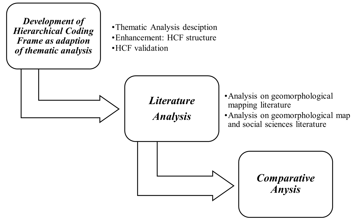
2.1. Development of Hierarchical Coding Frame (HCF) as an Adaptation of Thematic Analysis
2.1.1. Thematic Analysis Description
2.1.2. Enhancement: HCF Structure
2.1.3. HCF Validation
2.2. Literature Analysis
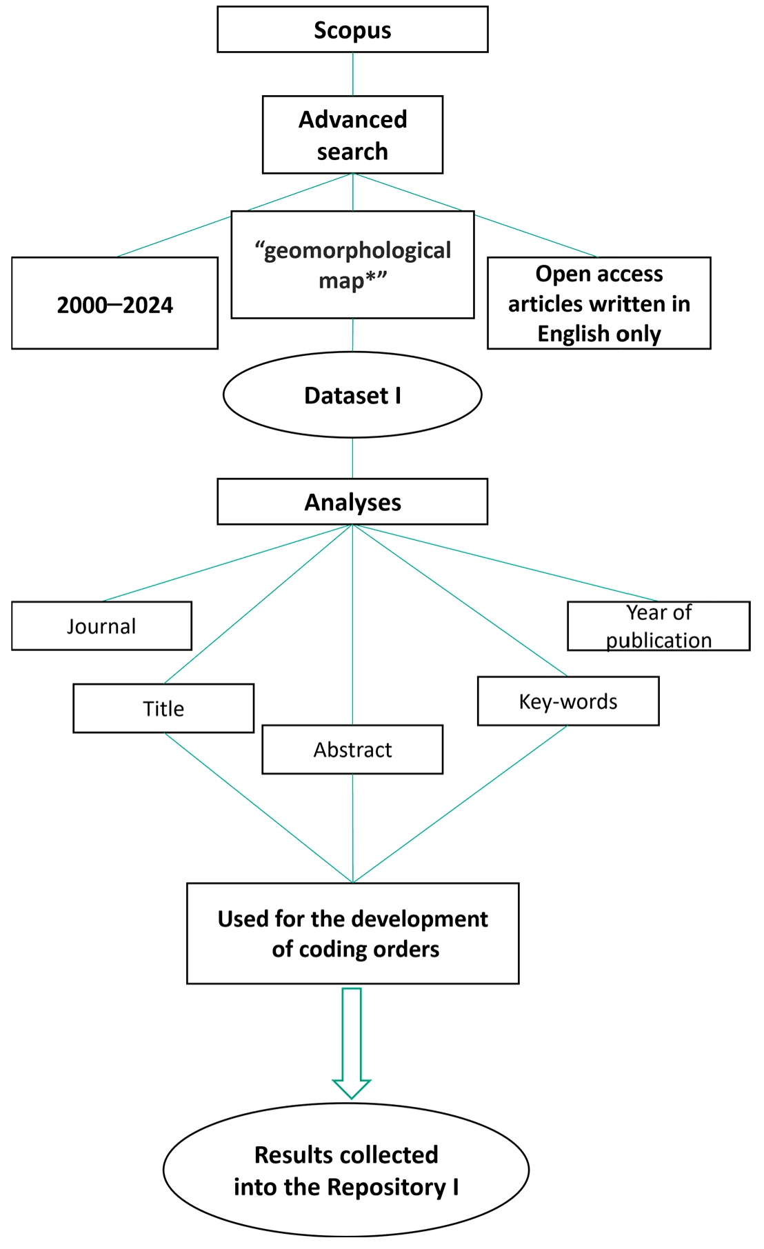
2.2.1. Analysis on Geomorphological Mapping Literature Through HCF Methodology
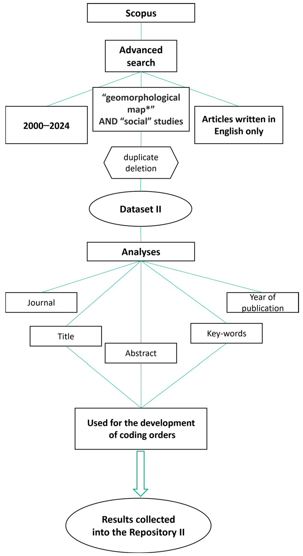
2.2.2. Analysis on Geomorphological Mapping and Social Literature Through HCF Methodology
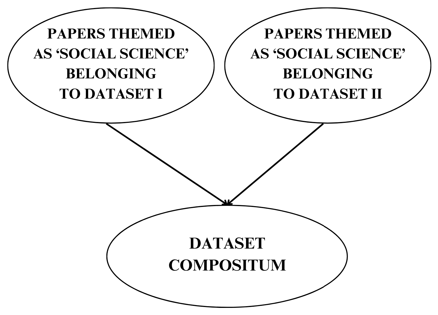
2.3. Comparative Analysis
3. Results
3.1. Validation of Hierarchical Coding Frame (HCF): Results and Evidence of Reliability
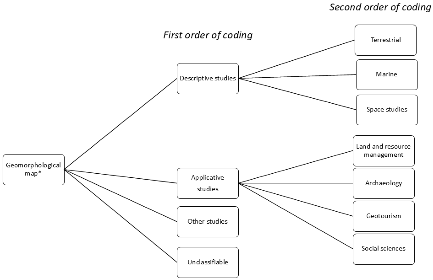
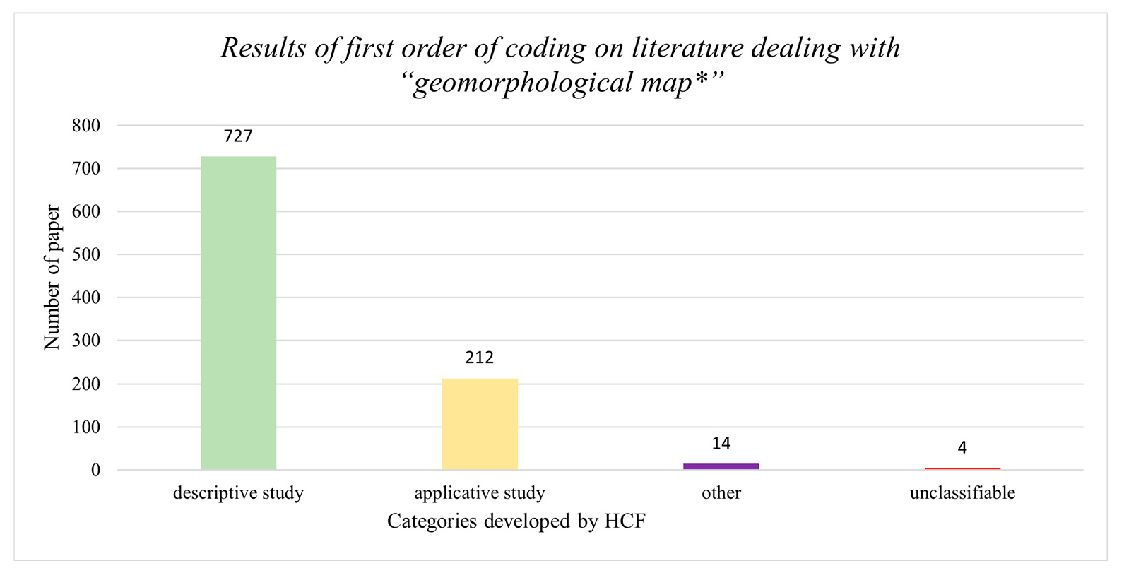
- Applicative studies, including all the literature presenting application models of geomorphological maps, e.g., [57], or papers in which geomorphological maps are used in an interdisciplinary context, e.g., [58], or articles in which maps are used as a cultural vehicle for the dissemination of knowledge [59].
- Other studies, including all those articles that are not deeply related to geomorphology. The presence of this category is explained by the fact that Scopus searches for keywords within the metadata. This means that an article may be included in the results even if the key appears only in references or in secondary descriptions, without necessarily representing the main topic of the article.
- Unclassifiable, including all articles that do not present abstracts or whose site is not accessible. These conditions made it impossible to develop any order of coding for these articles.
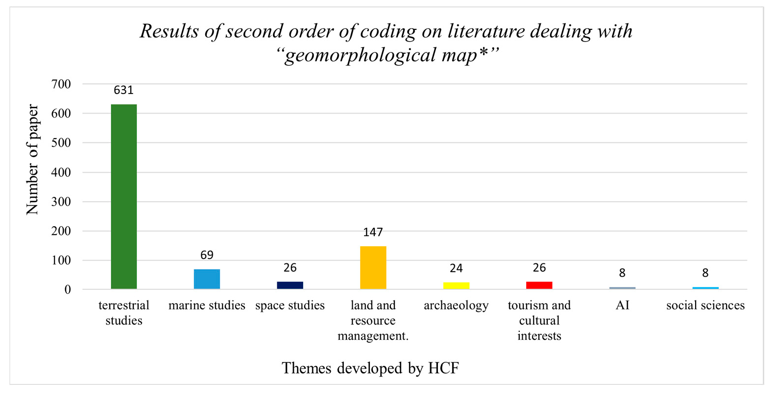
- Terrestrial studies, including all descriptive articles dealing with terrestrial geomorphology.
- Marine studies, including all descriptive articles dealing with coastal and marine geomorphology.
- Space studies, including all descriptive articles dealing with extra-terrestrial geomorphology (e.g., geomorphology of Venus, Mars, and so on).
- The themes developed for the applicative studies category are:
- Land and source management, including all applicative articles dealing with territorial management.
- Archaeology, including all applicative articles dealing with archaeology.
- Geotourism, including all applicative articles dealing with geotourism.
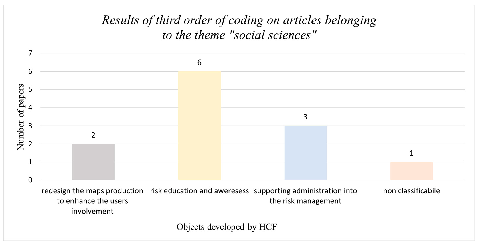
- Social sciences, including all applicative articles dealing with a broad interest in the communities.
3.2. Literature Analysis Results
3.2.1. Results of Qualitative Analysis on the Literature Dealing with “Geomorphological Map*”
3.2.2. Results of Qualitative Analysis of the Literature Dealing with “Geomorphological Map*” and “Social Studies”
3.3. The Comparative Analysis of Research Materials
4. Discussion
4.1. Implications of Geomorphological Maps on Social Context
4.2. Future Perspectives
5. Conclusions
Author Contributions
Funding
Data Availability Statement
Acknowledgments
Conflicts of Interest
Abbreviations
| HCF | Hierarchical Coding Frame |
References
- Slaymaker, O.; Spencer, T.; Embleton-Hamann, C. Recasting geomorphology as a landscape science. Geomorphology 2021, 384, 107723. [Google Scholar] [CrossRef]
- Panizza, M. Geomorfologia; Pitagora: Bologna, Italy, 1992. [Google Scholar]
- Otto, J.-C.; Smith, M.J. Geomorphological Mapping; Elsevier: Amsterdam, The Netherlands, 2013. [Google Scholar]
- Bishop, M.P.; James, L.A.; Shroder, J.F.; Walsh, S.J. Geospatial technologies and digital geomorphological mapping: Concepts, issues and research. Geomorphology 2012, 137, 5–26. [Google Scholar] [CrossRef]
- Quesada-Román, A.; Umaña-Ortíz, J.; Zumbado-Solano, M.; Islam, A.; Abioui, M.; Zangmo Tefogoum, G.; Kariminejad, N.; Mutaqin, B.W.; Pupim, F. Geomorphological regional mapping for environmental planning in developing countries. Environ. Dev. 2023, 48, 100935. [Google Scholar] [CrossRef]
- Raisz, E.J. The Physiographic Method of Representing Scenery on Maps. Geogr. Rev. 1931, 21, 297–304. [Google Scholar] [CrossRef]
- Lee, E.M. Geomorphological mapping. Geol. Soc. Spec. Publ. 2001, 18, 53–56. [Google Scholar] [CrossRef]
- Gustavsson, M.; Kolstrup, E.; Seijmonsbergen, A.C. A new symbol-and-GIS based detailed geomorphological mapping system: Renewal of a scientific discipline for understanding landscape development. Geomorphology 2006, 77, 90–111. [Google Scholar] [CrossRef]
- Van Westen, C.J.; Rengers, N.; Soeters, R. Use of geomorphological information in indirect landslide susceptibility assessment. Nat. Hazards 2003, 30, 399–419. [Google Scholar] [CrossRef]
- Verstappen, H.T. Old and New Trends in Geomorphological and Landform Mapping. Dev. Earth Surf. Process. 2011, 15, 13–38. [Google Scholar] [CrossRef]
- Guzzetti, F.; Carrara, A.; Cardinali, M.; Reichenbach, P. Landslide hazard evaluation: A review of current techniques and their application in a multi-scale study, Central Italy. Geomorphology 1999, 31, 181–216. [Google Scholar] [CrossRef]
- Vaughan, I.P.; Diamond, M.; Gurnell, A.M.; Hall, K.A.; Jenkins, A.; Milner, N.J.; Naylor, L.A.; Sear, D.A.; Woodward, G.; Ormerod, S.J. Integrating ecology with hydromorphology: A priority for river science and management. Aquat. Conserv. Mar. Freshw. Ecosyst. 2009, 19, 113–125. [Google Scholar] [CrossRef]
- Ruiz-Flaño, P.; García-Ruiz, J.M.; Ortigosa, L. Geomorphological evolution of abandoned fields. A case study in the Central Pyrenees. Catena 1992, 19, 301–308. [Google Scholar] [CrossRef]
- Keller, E.; Adamaitis, C.; Alessio, P.; Anderson, S.; Goto, E.; Gray, S.; Gurrola, L.; Morell, K. Applications in geomorphology. Geomorphology 2020, 366, 106729. [Google Scholar] [CrossRef]
- Ferrando, A.; Bosino, A.; Bonino, E.; Coratza, P.; Faccini, F. Geomorphology and geoheritage in the Piana Crixia Natural Park (NW Italy). J. Maps 2023, 19, 2257731. [Google Scholar] [CrossRef]
- Roy, E.D.; Morzillo, A.T.; Seijo, F.; Reddy, S.M.W.; Rhemtulla, J.M.; Milder, J.C.; Kuemmerle, T.; Martin, S.L. The Elusive Pursuit of Interdisciplinarity at the Human–Environment Interface. Prof. Biol. 2013, 63, 745–753. [Google Scholar] [CrossRef]
- Kirby, C.K.; Jaimes, P.; Lorenz-Reaves, A.R.; Libarkin, J.C. Development of a measure to evaluate competence perceptions of natural and social science. PLOS ONE 2019, 14, e0209311. [Google Scholar] [CrossRef] [PubMed]
- Marzano, M.; Carss, D.N.; Bell, S. Working to Make Interdisciplinarity Work: Investing in Communication and Interpersonal Relationships. J. Agric. Econ. 2006, 57, 185–197. [Google Scholar] [CrossRef]
- Graf, W.L. Geomorphology and American dams: The scientific, social, and economic context. Geomorphology 2005, 71, 3–26. [Google Scholar] [CrossRef]
- Kopp, R.E.; Gilmore, E.A.; Little, C.M.; Lorenzo-Trueba, J.; Ramenzoni, V.C.; Sweet, W.V. Usable Science for Managing the Risks of Sea-Level Rise. Earth’s Future 2019, 7, 1235–1269. [Google Scholar] [CrossRef] [PubMed]
- Paron, P.; Claessens, L. Makers and Users of Geomorphological Maps. Dev. Earth Surf. Process. 2011, 15, 75–106. [Google Scholar]
- Dramis, F.; Guida, D.; Cestari, A. Nature and aims of geomorphological mapping. Dev. Earth Surf. Process. 2011, 15, 39–73. [Google Scholar]
- Tranfield, D.; Denyer, D.; Smart, P. Towards a Methodology for Developing Evidence-Informed Management Knowledge by Means of Systematic Review. Br. J. Manag. 2003, 14, 207–222. [Google Scholar] [CrossRef]
- Church, M. Bed material transport and the morphology of alluvial river channels. Annu. Rev. Earth Planet. Sci. 2006, 34, 325–354. [Google Scholar] [CrossRef]
- Stott, T. Review of research in fluvial geomorphology 2010–2011. Prog. Phys. Geogr. 2013, 37, 248–258. [Google Scholar] [CrossRef]
- Whipple, K.X. Bedrock rivers and the geomorphology of active orogens. Annu. Rev. Earth Planet. Sci. 2004, 32, 151–185. [Google Scholar] [CrossRef]
- French, J.R.; Burningham, H. Coastal geomorphology: Trends and challenges. Prog. Phys. Geogr. 2009, 33, 117–129. [Google Scholar] [CrossRef]
- Naylor, L.A.; Stephenson, W.J.; Trenhaile, A.S. Rock coast geomorphology: Recent advances and future research directions. Geomorphology 2010, 114, 3–11. [Google Scholar] [CrossRef]
- Heckmann, T.; Cavalli, M.; Cerdan, O.; Foerster, S.; Javaux, M.; Lode, E.; Smetanová, A.; Vericat, D.; Brardinoni, F. Indices of sediment connectivity: Opportunities, challenges and limitations. Earth-Sci. Rev. 2018, 187, 77–108. [Google Scholar] [CrossRef]
- Najafi, S.; Dragovich, D.; Heckmann, T.; Sadeghi, S.H. Sediment connectivity concepts and approaches. CATENA 2021, 196, 104880. [Google Scholar] [CrossRef]
- Wohl, E.; Brierley, G.; Cadol, D.; Coulthard, T.J.; Covino, T.; Fryirs, K.A.; Grant, G.; Hilton, R.G.; Lane, S.N.; Magilligan, F.J.; et al. Connectivity as an emergent property of geomorphic systems. Earth Surf. Process. Landf. 2019, 44, 4–26. [Google Scholar] [CrossRef]
- La Licata, M.; Bosino, A.; Bettoni, M.; Maerker, M. Assessing landscape features and geomorphic processes influencing sediment dynamics in a geomorphologically highly active Mediterranean agroecosystem: The upper Val d’Arda case study (Northern Apennines, Italy). Geomorphology 2023, 433, 108724. [Google Scholar] [CrossRef]
- Joyce, K.E.; Belliss, S.E.; Samsonov, S.V.; McNeill, S.J.; Glassey, P.J. A review of the status of satellite remote sensing and image processing techniques for mapping natural hazards and disasters. Prog. Phys. Geogr. 2009, 33, 183–207. [Google Scholar] [CrossRef]
- Massonnet, D.; Feigl, K.L. Radar interferometry and its application to changes in the earth’s surface. Rev. Geophys. 1998, 36, 441–500. [Google Scholar] [CrossRef]
- Moore, I.D.; Grayson, R.B.; Ladson, A.R. Digital terrain modelling: A review of hydrological, geomorphological, and biological applications. Hydrol. Process. 1991, 5, 3–30. [Google Scholar] [CrossRef]
- Quesada-Román, A.; Peralta-Reyes, M. Geomorphological Mapping Global Trends and Applications. Geographies 2023, 3, 610–621. [Google Scholar] [CrossRef]
- Braun, V.; Clarke, V. Using thematic analysis in psychology. Qual. Res. Psychol. 2006, 3, 77–101. [Google Scholar] [CrossRef]
- Braun, V.; Clarke, V.; Hayfield, N.; Terry, G. Thematic Analysis. In Handbook of Research Methods in Health Social Sciences; Springer: Berlin/Heidelberg, Germany, 2019; pp. 843–860. [Google Scholar] [CrossRef]
- Castleberry, A.; Nolen, A. Thematic Analysis of Qualitative Research Data: Is It as Easy as It Sounds? Curr. Pharm. Teach. Learn. 2018, 10, 807–815. [Google Scholar] [CrossRef] [PubMed]
- Dawadi, S. Thematic Analysis Approach: A Step by Step Guide for ELT Research Practitioners. J. NELTA 2020, 25, 62–71. [Google Scholar] [CrossRef]
- King, N. Using templates in the thematic analysis of text. In Essential Guide to Qualitative Methods in Organizational Research; Cassell, C., Symon, G., Eds.; SAGE Publications Ltd.: London, UK, 2004; pp. 256–270. [Google Scholar] [CrossRef]
- Naeem, M.; Ozuem, W.; Howell, K.; Ranfagni, S. A Step-by-Step Process of Thematic Analysis to Develop a Conceptual Model in Qualitative Research. Int. J. Qual. Methods 2023, 22, 16094069231205789. [Google Scholar] [CrossRef]
- Nowell, L.S.; Norris, J.M.; White, D.E.; Moules, N.J. Thematic Analysis: Striving to Meet the Trustworthiness Criteria. Int. J. Qual. Methods 2017, 16, 1609406917733847. [Google Scholar] [CrossRef]
- Ahi, P.; Searcy, C. A comparative literature analysis of definitions for green and sustainable supply chain management. J. Clean. Prod. 2013, 52, 329–341. [Google Scholar] [CrossRef]
- Hamidova, E.; Bosino, A.; Franceschi, L.; De Amicis, M. Nature-Based Solution Integration to Enhance Urban Geomorphological Mapping: A Methodological Approach. Land 2024, 13, 467. [Google Scholar] [CrossRef]
- Fereday, J.; Muir-Cochrane, E. Demonstrating Rigor Using Thematic Analysis: A Hybrid Approach of Inductive and Deductive Coding and Theme Development. Int. J. Qual. Methods 2006, 5, 80–92. [Google Scholar] [CrossRef]
- Cochran, W.G. Sampling Techniques, 3rd ed.; Wiley: Hoboken, NJ, USA, 1977. [Google Scholar]
- Krejcie, R.V.; Morgan, D.W. Determining Sample Size for Research Activities. Educ. Psychol. Meas. 1970, 30, 607–610. [Google Scholar] [CrossRef]
- Adriaanse, L.S.; Rensleigh, C. Web of Science, Scopus and Google Scholar: A content comprehensiveness comparison. Electron. Libr. 2013, 31, 727–744. [Google Scholar] [CrossRef]
- Pranckutė, R. Web of Science (WoS) and Scopus: The titans of bibliographic information in today’s academic world. Publications 2021, 9, 12. [Google Scholar] [CrossRef]
- Abdi, J.; Al-Hindawi, A.; Ng, T.; Vizcaychipi, M.P. Scoping review on the use of socially assistive robot technology in elderly care. BMJ Open 2018, 8, e018815. [Google Scholar] [CrossRef] [PubMed]
- Zyoud, S.H.; Waring, W.S.; Al-Jabi, S.W.; Sweileh, W.M. Bibliometric profile of global scientific research on digoxin toxicity (1849–2015). Drug Chem. Toxicol. 2020, 43, 553–559. [Google Scholar] [CrossRef] [PubMed]
- Noor, M.I.M.; Lim, V.-C.; Mustafa, A.M.A.A.; Azzeri, A.; Jaafar, M.H.; Shah, N.K.M.; Hussin, N.S.; Zainal, M.A.; Abdullah, M.F. Photovoice method trends, status and potential for future participatory research approach. Malays. J. Public Health Med. 2022, 22, 252–266. [Google Scholar] [CrossRef]
- Rączkowska, Z.; Zwoliński, Z. Digital geomorphological map of Poland. Geogr. Pol. 2015, 88, 205–210. [Google Scholar] [CrossRef][Green Version]
- Embabi, N.S.; Moawad, M.B. A semi-automated approach for mapping geomorphology of El Bardawil Lake, Northern Sinai, Egypt, using integrated Remote Sensing and GIS techniques. Egypt. J. Remote Sens. Space Sci. 2014, 17, 41–60. [Google Scholar] [CrossRef]
- Barbosa, T.S.; Furrier, M. Anthropogenic Geomorphological Mapping of the Central Sector of the João Pessoa Metropolitan Region (PB), Brazil. RBGeomorfologia 2023, 24. [Google Scholar] [CrossRef]
- Madeira, M.R.; Alves, E.A.C.; Simon, A.L.H. Spatial concentration of geomorphological heritage elements in Guaritas do Camaquã geomorphosite (Rio Grande do sul-Brazil). Rev. Bras. Geomorfol. 2021, 22, 275–295. [Google Scholar] [CrossRef]
- Gómez, J.C.; Magnin, L. Geomorphologic mapping applied to archaeological studies at Deseado Massif (Patagonia Argentina). Investig. Geogr. 2008, 65, 22–37. [Google Scholar]
- Contillo, L.; Zingaro, M.; Capolongo, D.; Corrado, G.; Schiattarella, M. Geomorphology and geotourism for a sustainable development of the Daunia Mts, Southern Italy. J. Maps 2022, 18, 418–427. [Google Scholar] [CrossRef]
- Rodríguez, Á.S.; García, A.R.; de Luis, R.C. The Fonfría paleolandslide (Villablino, Cantabrian Mountains). Geogaceta 2023, 74, 55–58. [Google Scholar] [CrossRef]
- Paul, O.J.; Romshoo, S.A.; Dar, R.A.; Kumar, P.; Dhal, S.P.; Chopra, S. Paleo-glacial reconstruction of the Thajwas glacier in the Kashmir Himalaya using 10Be cosmogenic radionuclide dating. Geosci. Front. 2022, 13, 101432. [Google Scholar] [CrossRef]
- Bosino, A.; Bernini, A.; Botha, G.A.; Bonacina, G.; Pellegrini, L.; Omran, A.; Hochschild, V.; Sommer, C.; Maerker, M. Geomorphology of the upper Mkhomazi River basin, KwaZulu-Natal, South Africa, with emphasis on late Pleistocene colluvial deposits. J. Maps 2021, 17, 5–16. [Google Scholar] [CrossRef]
- Licata, M.; Fubelli, G. The GOGIRA System: An Innovative Method for Landslides Digital Mapping. Geosciences 2022, 12, 336. [Google Scholar] [CrossRef]
- Dramis, F.; Guida, D.; Valiante, M. Object-Oriented Mapping as a Tool for the Assessment of Landslide Hazard in Higly Urbanized Areas. Front. Earth Sci. 2022, 10, 834078. [Google Scholar] [CrossRef]
- Ghosh, A.; Bera, B. Landform classification and geomorphological mapping of the Chota Nagpur Plateau, India. Quat. Sci. Adv. 2023, 10, 100082. [Google Scholar] [CrossRef]
- Coratza, P.; Bollati, I.M.; Panizza, V.; Brandolini, P.; Castaldini, D.; Cucchi, F.; Deiana, G.; Del Monte, M.; Faccini, F.; Finocchiaro, F.; et al. Advances in geoheritage mapping: Application to iconic geomorphological examples from the italian landscape. Sustainability 2021, 13, 11538. [Google Scholar] [CrossRef]
- Marra, W.A.; van de Grint, L.; Alberti, K.; Karssenberg, D. Using GIS in an Earth Sciences field course for quantitative exploration, data management and digital mapping. J. Geogr. High. Educ. 2017, 41, 213–229. [Google Scholar] [CrossRef]
- Novak, A.; Popit, T.; Šmuc, A. Sedimentological and geomorphological characteristics of quaternary deposits in the planica-tamar valley in the julian alps (NW Slovenia). J. Maps 2018, 14, 382–391. [Google Scholar] [CrossRef]
- Cabrera, C.; Puig, P.; Durán, R.; Fabri, M.-C.; Guerin, C.; Lo Iacono, C.; Huvenne, V.A.I. Geomorphology and evolution of the Blanes Canyon (NW Mediterranean). New insights from high resolution mapping of vertical cliffs. Geomorphology 2024, 461, 109290. [Google Scholar] [CrossRef]
- Tirsch, D.; Bishop, J.L.; Voigt, J.R.C.; Tornabene, L.L.; Erkeling, G.; Jaumann, R. Geology of central Libya Montes, Mars: Aqueous alteration history from mineralogical and morphological mapping. Icarus 2018, 314, 12–34. [Google Scholar] [CrossRef]
- Vasconcelos, V.V.; Koontanakulvong, S.; Suthidhummajit, C.; Junior, P.P.M.; Hadad, R.M. Analysis of spatial–temporal patterns of water table change as a tool for conjunctive water management in the Upper Central Plain of the Chao Phraya River Basin, Thailand. Appl. Water Sci. 2017, 7, 245–262. [Google Scholar] [CrossRef]
- Beuzen-Waller, T.; Desruelles, S.; Marrast, A.; Giraud, J.; Gernez, G.; Forman, S.; Beshkani, A.; Bonilauri, S.; Lemée, M.; Nacarro, H.; et al. Late Pleistocene-Holocene fluvial records of the Wadi Dishshah: Hydro-climatic and archaeological implications (Southern piedmont of the Hajar Mountains, Oman). Geomorphol. Relief Process. Environ. 2022, 28, 223–239. [Google Scholar] [CrossRef]
- Mall, U.; Kloskowski, D.; Laserstein, P. Artificial intelligence in remote sensing geomorphology—A critical study. Front. Astron. Space Sci. 2023, 10, 1176325. [Google Scholar] [CrossRef]
- Sharma, S.K.; Aryal, J.; Shao, Q.; Rajabifard, A. Characterizing Topographic Influences of Bushfire Severity Using Machine Learning Models: A Case Study in a Hilly Terrain of Victoria, Australia. IEEE J. Sel. Top. Appl. Earth Obs. Remote Sens. 2023, 16, 2791–2807. [Google Scholar] [CrossRef]
- van der Meij, W.M.; Meijles, E.W.; Marcos, D.; Harkema, T.T.L.; Candel, J.H.J.; Maas, G.J. Comparing geomorphological maps made manually and by deep learning. Earth Surf. Process. Landf. 2022, 47, 1089–1107. [Google Scholar] [CrossRef]
- Bollati, I.; Crosa Lenz, B.; Zanoletti, E.; Pelfini, M. Geomorphological mapping for the valorization of the alpine environment. A methodological proposal tested in the Loana Valley (Sesia Val Grande Geopark, Western Italian Alps). J. Mt. Sci. 2017, 14, 1023–1038. [Google Scholar] [CrossRef]
- Booth, K.A.; Brayson, J. Geology, landscape and human interactions: Examples from the Isle of Wight. Proc. Geol. Assoc. 2011, 122, 938–948. [Google Scholar] [CrossRef]
- Carabella, C.; Boccabella, F.; Buccolini, M.; Ferrante, S.; Pacione, A.; Gregori, C.; Pagliani, T.; Piacentini, T.; Miccadei, E. Geomorphology of landslide–flood-critical areas in hilly catchments and urban areas for EWS (Feltrino Stream and Lanciano town, Abruzzo, Central Italy). J. Maps 2021, 17, 40–53. [Google Scholar] [CrossRef]
- Díaz Balocchi, L.; Ponce, J.F.; Tripaldi, A.; Magneres, I. Geomorphology of the northeastern extreme of Isla Grande de Tierra del Fuego, Argentina. J. Maps 2020, 16, 512–523. [Google Scholar] [CrossRef]
- Frodella, W.; Spizzichino, D.; Ciampalini, A.; Margottini, C.; Casagli, N. Hydrography and geomorphology of Antananarivo High City (Madagascar). J. Maps 2021, 17, 215–226. [Google Scholar] [CrossRef]
- Griffiths, J.S.; Abraham, J.K. Factors affecting the use of applied geomorphology maps to communicate with different end-users. J. Maps 2008, 4, 201–210. [Google Scholar] [CrossRef]
- Cunha, P.P.; Martins, A.A.; Buylaert, J.-P.; Murray, A.S.; Raposo, L.; Mozzi, P.; Stokes, M. New data on the chronology of the Vale do Forno sedimentary sequence (Lower Tejo River terrace staircase) and its relevance as a fluvial archive of the Middle Pleistocene in western Iberia. Quat. Sci. Rev. 2017, 166, 204–226. [Google Scholar] [CrossRef]
- He, S.; Wang, D.; Li, Y.; Zhao, P.; Lan, H.; Chen, W.; Jamali, A.A.; Chen, X. Social-ecological system resilience of debris flow alluvial fans in the Awang basin, China. J. Environ. Manag. 2021, 286, 112230. [Google Scholar] [CrossRef] [PubMed]
- Mague, S.T. Retracing the past: Recovering 19th century benchmarks to measure shoreline change along the outer shore of cape cod, Massachusetts. Cartogr. Geogr. Inf. Sci. 2012, 39, 30–47. [Google Scholar] [CrossRef]
- Kongeswaran, T.; Karikalan, R. A study on the evolution of coastal geomorphology between Rameshwaram and Kilakkarai, east coast of India. Indian J. Geo-Mar. Sci. 2021, 50, 67–70. [Google Scholar]
- Obodoefuna, D.C.; Fan, D.; Guo, X.; Li, B. Highly accelerated siltation of abandoned distributary channel in the Yangtze Delta under everchanging social-ecological dynamics. Mar. Geol. 2020, 429, 106331. [Google Scholar] [CrossRef]
- Sudarsana Raju, G.; Raghu Babu, K.; Gangi Reddy, S.; Ravikumar, M. Identification of groundwater potential zones by using remote sensing data in and around nandimandalam and Kothapalle, Kadapa District, Andhra Pradesh. Indian J. Environ. Prot. 2009, 29, 690–704. [Google Scholar]
- Goldstein, P.S.; Magilligan, F.J. Hazard, risk and agrarian adaptations in a hyperarid watershed: El Niño floods, streambank erosion, and the cultural bounds of vulnerability in the Andean Middle Horizon. Catena 2011, 85, 155–167. [Google Scholar] [CrossRef]
- Arisci, A.; De Waele, J.; Di Gregorio, F.; Ferrucci, I.; Follesa, R. Geoenvironmental Analysis in Coastal Zone Management: A Case Study in Southwest-Sardinia (Italy). J. Coast. Res. 2003, 19, 963–970. [Google Scholar]
- Mǎrgǎrint, M.C.; Grozavu, A.; Condorachi, D.; Pleşcan, S.; Boamfǎ, I. Geomorphometric features of the built areas of the localities along Iaşi Cuesta. Geogr. Tech. 2010, 2, 79–89. [Google Scholar]
- de Andrade, M.M.N.; Szlafsztein, C.F. Community participation in flood mapping in the Amazon through interdisciplinary methods. Nat. Hazards 2015, 78, 1491–1500. [Google Scholar] [CrossRef]
- Eshita, N.R.; Bhuiyan, M.A.H.; Saadat, A.H.M. Recent morphological shifting of Padma River: Geoenvironmental and socioeconomic implications. Nat. Hazards 2023, 117, 447–472. [Google Scholar] [CrossRef]
- Kilburn, C.R.J.; Pasuto, A. Major risk from rapid, large-volume landslides in Europe (EU Project RUNOUT). Geomorphology 2003, 54, 3–9. [Google Scholar] [CrossRef]
- Shen, S.-M.; Chen, Y.-H.; Lo, C.-M.; Yu, M.-T.; Lin, S.-C.; Wang, S.; Chang, C.-H.; Lin, S.-C. A user-centered mapping design for geomorphological hazard thematic map. J. Maps 2023, 19, 2251510. [Google Scholar] [CrossRef]
- Bulmer, M. Social Survey, History of. In International Encyclopedia of the Social & Behavioral Sciences; Pergamon: Oxford, UK, 2001; pp. 14469–14473. [Google Scholar] [CrossRef]
- Ali, I.; Azman, A.; Mallick, S.; Sultana, T.; Hatta, Z.A. Social Survey Method. In Principles of Social Research Methodology; Islam, M.R., Khan, N.A., Baikady, R., Eds.; Springer Nature: Singapore, 2022; pp. 167–179. ISBN 978-981-19-5441-2. [Google Scholar]
- Tseng, M.M.; Wang, Y.; Jiao, R.J. Mass Customization. In CIRP Encyclopedia of Production Engineering; Springer: Berlin/Heidelberg, Germany, 2017; pp. 1–8. [Google Scholar]
- Kumar, A. From mass customization to mass personalization: A strategic transformation. Int. J. Flex. Manuf. Syst. 2007, 19, 533–547. [Google Scholar] [CrossRef]
- Bosino, A.; La Licata, M.; Franceschi, L.; Hafiz, A.; Maggi, V.; Maerker, M.; Szatten, D. Multi-strata geomorphological database (MorphDB): A methodological breakthrough in geomorphological mapping approach. Geogr. Fis. Din. Quat. 2024, 47, 147–160. [Google Scholar]

| a. Thematic Analysis by Nowell et al. (2017) [43] | b. Hierarchical Coding Frame | ||
|---|---|---|---|
| Stage Name | Description | Stage Name | Description |
| Familiarising yourself with your data | Prolong engagement with data | Creation of datasets | Select the appropriate literature sample |
| Preliminary examination of data | Prolong engagement with data | ||
| Generation of initial codes | Development of a coding framework | Development of categories | Identify general purposes by transforming complex data into categories |
| Searching for themes | Development of a theme framework | Searching and developing themes | Identify specific purposes for linking similar categories |
| Reviewing themes | Diagramming to make sense of theme connections | ||
| Defining and naming themes | Peer debriefing and team consensus on themes | ||
| Development of objects | Identify material objectives to link similar practices | ||
| Producing the report | Report on reasons for theoretical, methodological and analytical choices throughout the entire study | Deducing a conceptual model | Create an outline to represent the content |
| N | S | N | S | N | S |
|---|---|---|---|---|---|
| 100 | 80 | 1100 | 285 | 2000 | 322 |
| 300 | 169 | 1300 | 297 | 2600 | 335 |
| 500 | 217 | 1500 | 306 | 3000 | 341 |
| 700 | 248 | 1700 | 313 | 3500 | 346 |
| 900 | 296 | 1900 | 320 | 4000 | 351 |
| Cartographic and Topographical Data | Elevation Data and Digital Terrain Models | Aerial and Satellite Imaging | Climate and Environmental Data | Mapping and Field Survey Instruments | Social Data | Other Support Data | |
|---|---|---|---|---|---|---|---|
| Bollati et al. (2017) [76] | X | X | X | X | |||
| Booth and Brayson, (2011) [77] | X | X | X | X | |||
| Carabella et al. (2021) [78] | X | X | X | X | X | X | |
| de Andrade and Szlafsztein, (2015) [91] | X | X | X | X | X | ||
| Díaz Balocchi et al. (2020) [79] | X | X | X | ||||
| Eshita et al. (2023) [92] | X | X | X | X | |||
| Frodella et al. (2020) [80] | X | X | X | ||||
| Griffiths and Abraham, (2008) [81] | X | X | X | ||||
| Kilburn and Pasuto, (2003) [93] | X | X | X | X | |||
| Shen et al. (2023) [94] | X | X | X | X |
Disclaimer/Publisher’s Note: The statements, opinions and data contained in all publications are solely those of the individual author(s) and contributor(s) and not of MDPI and/or the editor(s). MDPI and/or the editor(s) disclaim responsibility for any injury to people or property resulting from any ideas, methods, instructions or products referred to in the content. |
© 2025 by the authors. Licensee MDPI, Basel, Switzerland. This article is an open access article distributed under the terms and conditions of the Creative Commons Attribution (CC BY) license (https://creativecommons.org/licenses/by/4.0/).
Share and Cite
Franceschi, L.; Bosino, A.; La Licata, M.; De Amicis, M. Geomorphological Mapping and Social Sciences: A Qualitative Review. Geosciences 2025, 15, 271. https://doi.org/10.3390/geosciences15070271
Franceschi L, Bosino A, La Licata M, De Amicis M. Geomorphological Mapping and Social Sciences: A Qualitative Review. Geosciences. 2025; 15(7):271. https://doi.org/10.3390/geosciences15070271
Chicago/Turabian StyleFranceschi, Laura, Alberto Bosino, Manuel La Licata, and Mattia De Amicis. 2025. "Geomorphological Mapping and Social Sciences: A Qualitative Review" Geosciences 15, no. 7: 271. https://doi.org/10.3390/geosciences15070271
APA StyleFranceschi, L., Bosino, A., La Licata, M., & De Amicis, M. (2025). Geomorphological Mapping and Social Sciences: A Qualitative Review. Geosciences, 15(7), 271. https://doi.org/10.3390/geosciences15070271


