Next Issue
Volume 16, October-1
Previous Issue
Volume 16, September-1
 
 
water-logo

Journal Browser

Journal Browser

Water, Volume 16, Issue 18 (September-2 2024) – 149 articles

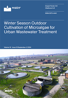
Cover Story (view full-size image): The use of microalgae for phycoremediation has been widely studied on a laboratory scale with various types of wastewater (WW) and algal strains both from collections and of indigenous sources. Several studies show that algae isolated from the WW to be treated are often more efficient due to their adaptation to the polluted medium. In the present study, an autochthonous Chlorella-strain alga, isolated from the supernatant of the sludge thickening process provided by the Hera-Ferrara urban WW treatment plant, was used. This alga had shown to be a promising candidate in laboratory-scale phytoremediation. The test was conducted in early and late winter (December 2021 and February 2022, respectively) in a large-scale pilot plant exposed to seasonal environmental conditions aimed to determine the strain efficiency under low-temperature environmental stress. View this paper
  • Issues are regarded as officially published after their release is announced to the table of contents alert mailing list.
  • You may sign up for e-mail alerts to receive table of contents of newly released issues.
  • PDF is the official format for papers published in both, html and pdf forms. To view the papers in pdf format, click on the "PDF Full-text" link, and use the free Adobe Reader to open them.
Order results
Result details
Section
Select all
Export citation of selected articles as:
17 pages, 9382 KiB  
Article
Spatiotemporal Variation and Influences of Acidification in the North Pacific, 1995–2019
by Xun Wang, Jie Wang, Jingjing Mao and Jiaming Liu
Water 2024, 16(18), 2705; https://doi.org/10.3390/w16182705 - 23 Sep 2024
Viewed by 802
Abstract
The continuous rise in atmospheric CO2 levels has led to persistent ocean acidification, which negatively impacts marine environments crucial for marine life and alters the chemical composition of seawater. This phenomenon carries significant implications for human society. Utilizing surface seawater pH data [...] Read more.
The continuous rise in atmospheric CO2 levels has led to persistent ocean acidification, which negatively impacts marine environments crucial for marine life and alters the chemical composition of seawater. This phenomenon carries significant implications for human society. Utilizing surface seawater pH data from the North Pacific spanning 1995 to 2019, this study investigates the overall and localized spatiotemporal variations in pH within the region, as well as the factors influencing these variations. Additionally, it conducts a quantitative analysis of the different influencing factors. The findings reveal a consistent downward trend in surface seawater pH in the North Pacific, decreasing from 8.073 to 8.029, with notable seasonal variations. The highest pH values are recorded in winter, followed by spring, with lower values in autumn and summer. Spatially, the pH values are higher in the northwest and lower in the southeast, with the most pronounced acidification occurring in the central and western regions, while other areas exhibit more uniform acidification levels. Spatial correlation analysis indicates that surface seawater pH in the North Pacific generally shows a negative correlation with sea surface temperature (SST), salinity (SSS), and chlorophyll-a concentration (chl a) and a positive correlation with dissolved oxygen (DO). Among these factors, SST exerts the greatest influence on seawater pH, followed by DO and SSS. The degree of acidification varies across different regions, and the dominant influencing factors differ accordingly. In the equatorial central region (A), the primary factors are chl a and SST; in the eastern regions of China and Japan (B) and the western region of Canada (C), DO and SSS are the main controlling factors. An interaction analysis of each pair of dominant factors using the geodetector shows that their respective contributions to regions A, B, and C are 70%, 90%, and 50%, respectively. Understanding the primary factors driving acidification in different regions can aid in comprehending the biological and environmental impacts of acidification in those areas and provide valuable insights for mitigating marine acidification. Full article
Show Figures

Figure 1

25 pages, 15422 KiB  
Article
Multi-Scale Variation in Surface Water Area in the Yellow River Basin (1991–2023) Based on Suspended Particulate Matter Concentration and Water Indexes
by Zhiqiang Zhang, Xinyu Guo, Lianhai Cao, Xizhi Lv, Xiuyu Zhang, Li Yang, Hui Zhang, Xu Xi and Yichen Fang
Water 2024, 16(18), 2704; https://doi.org/10.3390/w16182704 - 23 Sep 2024
Viewed by 630
Abstract
Surface water is a crucial part of terrestrial ecosystems and is crucial to maintaining ecosystem health, ensuring social stability, and promoting high-quality regional economic development. The surface water in the Yellow River Basin (YRB) has a high sediment content and spatially heterogeneous sediment [...] Read more.
Surface water is a crucial part of terrestrial ecosystems and is crucial to maintaining ecosystem health, ensuring social stability, and promoting high-quality regional economic development. The surface water in the Yellow River Basin (YRB) has a high sediment content and spatially heterogeneous sediment distribution, presenting a significant challenge for surface water extraction. In this study, we first analyze the applicability of nine water indexes in the YRB by using the Landsat series images (Landsat 5, 7, 8) and then examine the correlation between the accuracy of the water indexes and suspended particulate matter (SPM) concentrations. On this basis, we propose a surface water extraction method considering the SPM concentrations (SWE-CSPM). Finally, we examine the dynamic variations in the surface water in the YRB at four scales: the global scale, the secondary water resource zoning scale, the provincial scale, and the typical water scale. The results indicate that (1) among the nine water indexes, the MBWI has the highest water extraction accuracy, followed by the AWEInsh and WI2021, while the NDWI has the lowest. (2) Compared with the nine water indexes and the multi-index water extraction rule method (MIWER), the SWE-CSPM can effectively reduce the commission errors of surface water extraction, and the water extraction accuracy is the highest (overall accuracy 95.44%, kappa coefficient 90.62%). (3) At the global scale, the maximum water area of the YRB shows a decreasing trend, but the change amount is small. The permanent water area shows an uptrend, whereas the seasonal water area shows a downtrend year by year. The reason may be that the increase in surface runoff and the construction of reservoir projects have led to the transformation of some seasonal water into permanent water. (4) At the secondary water resource zoning scale, the permanent water area of other secondary water resource zonings shows an increasing trend in different degrees, except for the Interior Drainage Area. (5) At the provincial scale, the permanent water area of all provinces shows an uptrend, while the seasonal water areas show a fluctuating downtrend. The maximum water area of Shandong, Inner Mongolia Autonomous Region, and Qinghai increases slowly, while the other provinces show a decreasing trend. (6) At the typical water scale, there are significant differences in the water area variation process in Zhaling Lake, Eling Lake, Wuliangsuhai, Hongjiannao, and Dongping Lake, but the permanent water area and maximum water area of these waters have increased over the past decade. This study offers significant technical support for the dynamic monitoring of surface water and helps to deeply understand the spatiotemporal variations in surface water in the YRB. Full article
Show Figures

Figure 1

22 pages, 3493 KiB  
Article
A Coupled River–Overland (1D-2D) Model for Fluvial Flooding Assessment with Cellular Automata
by Hsiang-Lin Yu, Tsang-Jung Chang, Chia-Ho Wang and Shyh-Yuan Maa
Water 2024, 16(18), 2703; https://doi.org/10.3390/w16182703 - 23 Sep 2024
Viewed by 847
Abstract
To provide accurate and efficient forecasting of fluvial flooding assessment in the river basin, the present study links the well-known CA-based urban inundation modeling (2D-OFM-CA) with a one-dimensional river flow model (1D-RFM) as a coupled 1D-2D river–overland modeling. Rules to delineate the geometric [...] Read more.
To provide accurate and efficient forecasting of fluvial flooding assessment in the river basin, the present study links the well-known CA-based urban inundation modeling (2D-OFM-CA) with a one-dimensional river flow model (1D-RFM) as a coupled 1D-2D river–overland modeling. Rules to delineate the geometric linking between the 1D-RFM and 2D-OFM-CA along embankments are developed. The corresponding exchanged water volume across an embankment is then computed by using the free and submerged weir flow formulas. The applicability of the proposed coupled model on fluvial flooding assessment is then assessed and compared with a well-recognized commercial software (HEC-RAS model) through an idealized fluvial case and an extensively studied real-scale fluvial case in the Severn River Basin. Based on the simulated results concerning the numerical accuracy, the coupled model is found to give similar results in the aspects of the river flow and overland flow modeling in both two study cases, which demonstrates the effectiveness of the linking methodology between the 1D-RFM and 2D-OFM-CA. From the viewpoint of numerical efficiency, the coupled model is 47% and 41% faster than the HEC-RAS model in the two cases, respectively. The above results indicate that the coupled model can reach almost the same accuracy as the HEC-RAS model with an obvious reduction in its computational time. Hence, it is concluded that the coupled model has considerable potential to be an effective alternative for fluvial flooding assessment in the river basin. Full article
(This article belongs to the Special Issue Advances in Hydraulic and Water Resources Research (2nd Edition))
Show Figures

Figure 1

14 pages, 2456 KiB  
Article
Quantifying the Influence of Climatic and Anthropogenic Factors on Multi-Scalar Streamflow Variation of Jialing River, China
by Mengya Jia, Shixiong Hu, Xuyue Hu and Yuannan Long
Water 2024, 16(18), 2702; https://doi.org/10.3390/w16182702 - 23 Sep 2024
Viewed by 540
Abstract
Clarifying the impact of driving forces on multi-temporal-scale (annual, quarterly and monthly) runoff changes is of great significance for watershed water resource planning. Based on monthly runoff data and meteorological data of the Jialing River (JLR) during 1982–2020, the Mann–Kendall tendency testing approach [...] Read more.
Clarifying the impact of driving forces on multi-temporal-scale (annual, quarterly and monthly) runoff changes is of great significance for watershed water resource planning. Based on monthly runoff data and meteorological data of the Jialing River (JLR) during 1982–2020, the Mann–Kendall tendency testing approach was first applied to analyze variation tendencies of multi-timescale runoff. Then, abrupt variation years of runoff were determined using Pettitt and cumulative anomaly mutation testing approaches. The ABCD model was employed for simulating hydrological change processes in the base period and variation period. Finally, influences of climatic and anthropic factors on multi-scalar runoff were computed using the multi-scalar Budyko formula. The following conclusions were drawn in this study: (1) The mutation year of discharge was 1993; (2) the monthly runoff in the JLR presented a “single peak” distribution, and the concentration degree and concentration period in the JLR both showed an insignificant reduction trend; (3) anthropic factors were the dominant factor for spring runoff variations; climatic factors were the dominant factor on annual, summer, fall and winter runoff variations; (4) except for November, climatic factors were the dominant factor causing runoff changes in the other 11 months. This study has important reference value for water resource allocation and flood control decisions in the JLR. Full article
Show Figures

Figure 1

15 pages, 1737 KiB  
Article
Evaluation of River Health and Human Well-Being in the Heihe River Basin Using the SMI-P Method: A Case Study of the Zhangye City
by Yucai Wang, Mao Li, Jin Zhao and Jin’e Yang
Water 2024, 16(18), 2701; https://doi.org/10.3390/w16182701 - 23 Sep 2024
Viewed by 527
Abstract
Oasis cities are central to the economic and social development as well as ecological sustainability in the arid region in Northwest China. This study aims to explore the balance between river health and human well-being of local residents in the Hexi River oasis, [...] Read more.
Oasis cities are central to the economic and social development as well as ecological sustainability in the arid region in Northwest China. This study aims to explore the balance between river health and human well-being of local residents in the Hexi River oasis, while also enhancing the effectiveness of water resource management within the basin. Utilizing the SMI-P method, we construct a ‘Happy River’ evaluation system that integrates goals, criteria, and indicators. We analyze the evaluation index system for ‘Happy River’ construction in the study area, specifically the Zhangye City section of the Heihe River Basin, and derive a comprehensive evaluation value for the ‘Happy River’ initiative. Additionally, we assess the fit attribute of the evaluation system using the coupled coordination degree model and harmony degree theory, thereby enhancing the rationality of the evaluation method and ensuring a more thorough examination process. The results indicate that from 2017 to 2021, the urban wastewater treatment rate and the degree of water quality excellence in the Zhangye City section of the Black River Basin represent the highest and lowest weights, respectively, within the evaluation system. This suggests that improving the quality of the urban water environment has emerged as the primary factor influencing the assessment of the Happy River during the construction of the Happy River and Happy Lake. Moreover, ecological health is identified as the most significant criterion in the evaluation system, serving as the main factor affecting residents’ perceptions of happiness related to rivers and lakes. Over the five-year period, the happiness level in the study area improved from “relatively happy” to “very happy”, while the coupling coordination degree increased from 0.605 to 0.687, indicating a gradual progression toward coordinated development. Simultaneously, the harmony degree rose from 0.527 to 0.601, suggesting a tendency towards a condition of basic harmony. Additionally, the happiness index increased from 76.71 to 81.97, transitioning from a state of happiness to one of very high happiness. The composite index also improved, rising from 0.459 to 0.526, which demonstrates the preliminary success of the ‘Happy River’ construction efforts in the study area. The evaluation system and model of the ‘Happy River’, along with the final results of this study, can serve as theoretical references for the development of similar initiatives in typical characteristic rivers within the arid region of Northwest China. Full article
(This article belongs to the Section Water Use and Scarcity)
Show Figures

Figure 1

17 pages, 6828 KiB  
Article
Relationships between Precipitation and Elevation in the Southeastern Tibetan Plateau during the Active Phase of the Indian Monsoon
by Lun Luo, Yanggang Zhao, Yanghai Duan, Zeng Dan, Sunil Acharya, Gesang Jimi, Pan Bai, Jie Yan, Liang Chen, Bin Yang and Tianli Xu
Water 2024, 16(18), 2700; https://doi.org/10.3390/w16182700 - 23 Sep 2024
Viewed by 493
Abstract
The precipitation gradient (PG) is a crucial parameter for watershed hydrological models. Analysis of daily precipitation and elevation data from 30 stations in the southeastern Tibetan Plateau (SETP) during the active phase of the Indian monsoon reveals distinct patterns. Below 3000 m, precipitation [...] Read more.
The precipitation gradient (PG) is a crucial parameter for watershed hydrological models. Analysis of daily precipitation and elevation data from 30 stations in the southeastern Tibetan Plateau (SETP) during the active phase of the Indian monsoon reveals distinct patterns. Below 3000 m, precipitation generally decreases with increasing altitude. Between 3000 and 4000 m, precipitation patterns are more complex; in western regions, precipitation increases with elevation, whereas in eastern regions, it decreases. Above 4000 m, up to the highest observation point of 4841 m, precipitation continues to decrease with elevation, with a more pronounced decline beyond a critical height. In the SETP, PGs for LYR and NYR are positive, at 11.3 ± 2.7 mm/100 m and 17.3 ± 3.8 mm/100 m, respectively. Conversely, PLZB exhibits a negative PG of −22.3 ± 4.2 mm/100 m. The Yarlung Zangbo River (YLZBR) water vapor channel plays a significant role in these PGs, with the direction and flux of water vapor potentially influencing both the direction and magnitude of the PG. Additional factors such as precipitation intensity, the number of precipitation days, precipitation frequency, and station selection also significantly impact the PG. Notable correlations between elevation and variables such as the number of precipitation days, non-precipitation days, and precipitation intensity. The precipitation intensity gradients (PIGs) are 0.06 ± 0.02 mm/d/100 m, 0.11 ± 0.04 mm/d/100 m, and −0.18 ± 0.04 mm/d/100 m for the three catchments, respectively. Future research should incorporate remote sensing data and expand site networks, particularly in regions above 5000 m, to enhance the accuracy of precipitation–elevation relationship assessments, providing more reliable data for water resource simulation and disaster warning. Full article
Show Figures

Figure 1

18 pages, 3532 KiB  
Article
Health Risk of Heavy Metals in Drinking Water Sources of Water-Carrying Lakes Affected by Retreating Polder: A Case Study of Luoma Lake
by Jindong Wang, Xiaolong Zhu, Yicong Dai, Minyue Xu, Dongmei Wang, Yingcai Han, Wenguang Liang, Yifan Shi, Fanhao Song, Li Yao, Yiming Zhen and Qiuheng Zhu
Water 2024, 16(18), 2699; https://doi.org/10.3390/w16182699 - 23 Sep 2024
Viewed by 1092
Abstract
Heavy metal pollution is a critical issue affecting the safety of drinking water sources. However, the impact of human activities on heavy metal risk levels in water-carrying lakes remains unclear. This study aims to explore the risk mechanisms of heavy metals in Luoma [...] Read more.
Heavy metal pollution is a critical issue affecting the safety of drinking water sources. However, the impact of human activities on heavy metal risk levels in water-carrying lakes remains unclear. This study aims to explore the risk mechanisms of heavy metals in Luoma Lake, an important water-carrying lake for the South-to-North Water Diversion Project. We explored the spatial and temporal differences in the distribution of heavy metals in Lake Luoma using methods such as the heavy metal pollution index (HPI) and assessed the risk variations using a health assessment model. The results indicated that heavy metal concentrations in water-carrying lakes generally decreased during the dry season, with Mn and Zn levels decreasing by 89.3% and 56.2%, respectively. The comprehensive score of HPI decreased by 13.16% following the retreating polder compared to the control area (Non-retreating polder area). Furthermore, the HPI at the drinking water intake was lower, which is closely associated with the elevated dissolved oxygen (DO) and oxidation–reduction potential (ORP) resulting from water diversion. The annual average health risk across the entire lake was not significant, with higher levels observed in the control area. The annual non-carcinogenic risk levels of Mn, Ni, Cu, Zn, and Pb range from 10−13 to 10−9, which are considered negligible risk levels. Notably, the carcinogenic risk posed by arsenic (As) through the drinking pathway reached 10−5 a−1, exceeding the maximum levels recommended by certain organizations. These findings provide a critical foundation for managing heavy metals in water-carrying drinking water sources. Full article
Show Figures

Figure 1

24 pages, 8453 KiB  
Article
Simulation and Analysis of Water Quality Improvement Measures for Plain River Networks Based on Infoworks ICM Model: Case Study of Baoying County, China
by Qiande Zhu, Kaibin Fang, Dexun Zhu, Xinran Li, Xiaoyu Chen, Song Han, Feng Chen, Chuang Gao, Jun Sun, RongJie Tang, Yu Chen and Siyuan Yin
Water 2024, 16(18), 2698; https://doi.org/10.3390/w16182698 - 23 Sep 2024
Viewed by 986
Abstract
The water environment of plain river networks can be self-cleaning to a certain extent, but if the wastewater load exceeds a certain threshold, it can disturb the natural balance and cause water pollution. This underlines the importance of water pollution control measures. However, [...] Read more.
The water environment of plain river networks can be self-cleaning to a certain extent, but if the wastewater load exceeds a certain threshold, it can disturb the natural balance and cause water pollution. This underlines the importance of water pollution control measures. However, the development of water pollution control measures requires a large number of hydrological and hydrodynamic parameters and the establishment of corresponding relationships through modelling. Therefore, this study mainly used the Infoworks ICM model to construct a detailed hydrological–hydrodynamic water environment analysis model for the Yundong area of Baoying County, Yangzhou City, China, screened the main pollution source areas and pollution time periods of the typical rivers in the study area, and proposed effective improvement measures according to the actual situation of the study area. The results show that after the synergistic effect of multiple measures, the water quality can reach the Class III standard (GB3838-2002). This study can provide a reference for the water environment management and improvement of the plain river network and has good application prospects. Full article
(This article belongs to the Section Water Quality and Contamination)
Show Figures

Figure 1

15 pages, 3769 KiB  
Article
Adsorption of Tricyclazole and 2,4-Dichlorophenoxyacetic Acid onto Biochar Produced from Anaerobically Digested Sludge
by Fen Wang and Yingjian Hou
Water 2024, 16(18), 2697; https://doi.org/10.3390/w16182697 - 23 Sep 2024
Viewed by 611
Abstract
Anaerobically digested sludge-derived biochar was produced through pyrolysis at 700 °C, called BC700. BC700 was characterized using a scanning electron microscope (SEM), X-ray diffractometer (XRD), Fourier-transform infrared spectroscopy (FTIR), and the Brunauer–Emmett–Teller (BET) method. The factors influencing the adsorption process and the mechanism [...] Read more.
Anaerobically digested sludge-derived biochar was produced through pyrolysis at 700 °C, called BC700. BC700 was characterized using a scanning electron microscope (SEM), X-ray diffractometer (XRD), Fourier-transform infrared spectroscopy (FTIR), and the Brunauer–Emmett–Teller (BET) method. The factors influencing the adsorption process and the mechanism involved in adsorbing tricyclazole and 2,4-D in single and binary systems were revealed. The theoretical maximum adsorption capacities of BC700 for tricyclazole and 2,4-D in a single system were 11.86 mg/g and 7.89 mg/g, respectively. In the binary system, the theoretical saturated adsorptive capacities of tricyclazole and 2,4-D were 5.27 mg/g and 3.20 mg/g, respectively. The adsorption of tricyclazole and 2,4-D by BC700, whether in single or binary systems, matched closely with the Freundlich isotherm and the pseudo-second-order model. This study indicates that anaerobically digested sludge-derived biochar is potentially valuable for removing pesticide contamination in surface water. Full article
Show Figures

Graphical abstract

16 pages, 1523 KiB  
Article
Detection and Measurement of Bacterial Contaminants in Stored River Water Consumed in Ekpoma
by Imokhai T. Tenebe, Eunice O. Babatunde, Nkpa M. Ogarekpe, Joshua Emakhu, Egbe-Etu Etu, Onome C. Edo, Maxwell Omeje and Nsikak U. Benson
Water 2024, 16(18), 2696; https://doi.org/10.3390/w16182696 - 23 Sep 2024
Viewed by 698
Abstract
This study was conducted in Ekpoma, a town dependent on rainwater and river water from nearby areas because of a lack of groundwater sources, and the physicochemical and bacteriological (heterotrophic plate count [HPC], total coliform count [TCC], and fecal coliform count [FCC]) properties [...] Read more.
This study was conducted in Ekpoma, a town dependent on rainwater and river water from nearby areas because of a lack of groundwater sources, and the physicochemical and bacteriological (heterotrophic plate count [HPC], total coliform count [TCC], and fecal coliform count [FCC]) properties of 123 stored river water samples grouped into five collection districts (EK1 to EK5). The results were compared with regulatory standards and previous regional studies to identify water quality trends. While most physicochemical properties met drinking water standards, 74% of samples had pH values > 8.5. Twenty-seven samples were fit for drinking, with EK4 having the highest number of bacterio-logically unsuitable samples. Ten bacterial species were identified, with Gram-negative short-rod species such as Escherichia coli, Klebsiella pneumoniae, and Salmonella typhimurium being predominant. HPC values varied from 367 × 10⁴ to 1320 × 10⁴ CFU/mL, with EK2 (2505 × 10⁴ CFU/mL) and EK5 (1320 × 10⁴ CFU/mL) showing particularly high counts. The TCC values ranged from 1049 × 10⁴ to 4400 × 10⁴ CFU/mL, and the FCC values from 130 × 10⁴ to 800 × 10⁴ CFU/mL, all exceeding WHO limits (1.0 × 10² CFU/mL). Historical data show no improvement in water quality, emphasizing the need for individuals to treat water properly before consumption. The findings provide baseline data for local water authorities and serve as a wake-up call for adequate water treatment, storage interventions, and community education on water security. Additionally, this study offers a practical process for improving the quality of water stored in similar regions. Full article
(This article belongs to the Special Issue Monitoring and Remediation of Contaminants in Soil and Water)
Show Figures

Figure 1

15 pages, 2198 KiB  
Article
Characterization of Escherichia coli Isolates in Recreational Waters: Implications for Public Health and One Health Approach
by Lúcia Gomes, Adriano A. Bordalo and Ana Machado
Water 2024, 16(18), 2695; https://doi.org/10.3390/w16182695 - 23 Sep 2024
Viewed by 968
Abstract
Escherichia coli is commonly found in the gastrointestinal tract of warm-blooded animals and is routinely used as an indicator of fecal contamination in recreational waters. While most E. coli are commensal, some can harbor pathogenic potential, posing a major public health risk. This [...] Read more.
Escherichia coli is commonly found in the gastrointestinal tract of warm-blooded animals and is routinely used as an indicator of fecal contamination in recreational waters. While most E. coli are commensal, some can harbor pathogenic potential, posing a major public health risk. This study investigated the sources of fecal contamination in recreational waters through the characterization of E. coli isolates. Presumptive E. coli detection was performed using selective and differential media, confirmed by PCR, and followed by characterization. E. coli were detected in all studied aquatic environments, with most isolates belonging to phylogenetic groups D1 (24%, non-human mammals) and B1 (20%, birds), suggesting animals as primary contaminants sources. Among E. coli isolates, 35% were identified as diarrheagenic E. coli (DEC), with enterotoxigenic (34%) and enterohemorrhagic (26%) being the most prevalent pathotypes. Furthermore, 85% of all isolates and 86.5% of DEC isolates exhibited multi-drug resistance, with highest rates displayed in phylogenetic subgroups A1 (human and non-human mammals) and B1. This study highlights the importance of the One Health approach encompassing a human, animal, and environmental holistic health perspective to effectively manage public health strategies and ensure the safety of beachgoers. Full article
(This article belongs to the Section Water and One Health)
Show Figures

Figure 1

17 pages, 5711 KiB  
Article
Study on Valley Shrink Deformation of the High Arch Dam with Large Faults near Dam Area during Initial Impoundment
by Yaolai Liu, Haijiang Wang, Long Yan, Jiyuan Yu, Wei Zeng and Weiya Xu
Water 2024, 16(18), 2694; https://doi.org/10.3390/w16182694 - 22 Sep 2024
Viewed by 664
Abstract
Valley shrink deformation is a common physical and mechanical phenomenon during the reservoir operation of high arch dams. This phenomenon is particularly significant in the initial stages of impoundment and can severely impact the operational safety of the arch dam. This study focuses [...] Read more.
Valley shrink deformation is a common physical and mechanical phenomenon during the reservoir operation of high arch dams. This phenomenon is particularly significant in the initial stages of impoundment and can severely impact the operational safety of the arch dam. This study focuses on the arch dam under construction in the upstream of the Lancang River. By considering the secondary structural planes F115 and F111 at the dam site, a numerical model of valley shrink deformation was established. The study investigates the characteristics of valley shrink deformation during the initial impoundment phase of the arch dam. The results show that during the impoundment process, the valley slopes on both sides of the reservoir shrink towards the center of the valley. The deformation on the right bank is greater than that on the left bank due to the influence of the F115 fault. When the elevation is lower than the exposure position of F115, the deformation on the right bank increases with elevation; when it is higher than this position, the deformation decreases. On the left bank, due to the influence of F111 and the seepage field, the deformation value increases first and then decreases with the increase in elevation. After the water level stabilizes, the deformation rate decreases and approaches zero. This research results provide a reference for addressing valley shrink deformation issues during the initial impoundment of the arch dam. Full article
(This article belongs to the Section Hydrogeology)
Show Figures

Figure 1

17 pages, 4494 KiB  
Article
Magnetized Saline Water Drip Irrigation Alters Soil Water-Salt Infiltration and Redistribution Characteristics
by Mingliang Xin, Qiao Zhao, Ying Qiao and Yingjie Ma
Water 2024, 16(18), 2693; https://doi.org/10.3390/w16182693 - 22 Sep 2024
Viewed by 754
Abstract
Magnetization constitutes an efficacious physical treatment technique applicable to saline water. The new spiral flow magnetizer, in conjunction with the cyclic magnetization process, has the effect of maximizing effective magnetization time and thereby achieving the optimal magnetization results. Based on this, saline water [...] Read more.
Magnetization constitutes an efficacious physical treatment technique applicable to saline water. The new spiral flow magnetizer, in conjunction with the cyclic magnetization process, has the effect of maximizing effective magnetization time and thereby achieving the optimal magnetization results. Based on this, saline water (0.27, 3, 6, and 10 g L−1) was treated with different levels of magnetization (0, 0.2, 0.4 and 0.6 T), and the effects of magnetized saline water (MSW) drip irrigation on loamy-sand soil moisture, soluble salt infiltration, and redistribution characteristics were studied through a vertical soil column simulation experiment. The results showed that the wetting front migration in MSW drip irrigation experiments exhibited minimal variation during soil water infiltration, and a notable change during redistribution with the experimental duration of 0.27 and 3g L−1 saline water treatments being significantly different (p < 0.05). Treating saline water with different mineralization levels with magnetization demonstrated water retention (0.27 g L−1 excluded) and salt drainage characteristics; calculated soil water storage increased by 1.58–14.19% and salt storage decreased by 0.22–7.66%. The optimal magnetization intensity for low-mineralization (0.27 and 3 g L−1) saline water was 0.2 T and for high-mineralization (6 and 10 g L−1) it was 0.6 T. The adsorption and exchange of cations (19.58–32.12%) by the optimum MSW treatments was greater than that of anions (9.46–14.15%); specifically, the relative exchange capacity of Ca2+ and Mg2+ in cations was more than K+ and Na+, while HCO3 and SO42− in anions was more than Cl. This study provides theoretical and technical support for the irrigation of farmland with poor-quality water, as well as for the development of magnetized water irrigation technology. Full article
(This article belongs to the Section Soil and Water)
Show Figures

Figure 1

22 pages, 3200 KiB  
Article
Migration as an Adaptation Measure to Achieve Resilient Lifestyle in the Face of Climate-Induced Drought: Insight from the Thar Desert in Pakistan
by Amir Hamza, Guoqing Shi and Babul Hossain
Water 2024, 16(18), 2692; https://doi.org/10.3390/w16182692 - 22 Sep 2024
Viewed by 1107
Abstract
A significant number of people, either seasonally or permanently, migrate from the Thar Desert in Pakistan each year due to droughts caused by climate change. This study aims to investigate the determinants and consequences of these migration decisions, examine the effectiveness of migration [...] Read more.
A significant number of people, either seasonally or permanently, migrate from the Thar Desert in Pakistan each year due to droughts caused by climate change. This study aims to investigate the determinants and consequences of these migration decisions, examine the effectiveness of migration as a climate adaptation strategy, and identify challenges in adapting to these changes. Data were gathered from 400 migrated households in the Mithi sub-district. A mixed-method approach was used, combining qualitative and quantitative methods. The findings revealed that threats to the standard of living, including lack of food and clean drinking water, unemployment, and limited educational and medical opportunities, were the primary reasons for permanent and temporary migration from ancestral locations. Migration significantly impacted the origin and destination regions, with positive or negative effects. Specifically, migrants identified various consequences for both the origin and destination communities, including population decline (63%), changes in age structure, increased demand for housing, economic fluctuations (73%), alterations in healthcare services, and increased psychological stress (77%). The study also revealed that individuals who migrated from the Thar Desert experienced improved conditions compared to their previous location, such as diversification of income sources, increased job stability, access to clean water and food, reduced health risks, and overall improvements in their living conditions. However, the destination communities faced significant challenges due to widespread resource depletion and environmental deterioration. Migrants encountered barriers to developing resilient livelihoods in destination areas, including lack of proper knowledge and information, institutional and government issues, environmental and technological challenges, and social and cultural issues. The study highlights the urgent need for comprehensive policies and sustainable solutions to address the root causes of migration and support the resilience of vulnerable populations. Full article
Show Figures

Figure 1

14 pages, 2385 KiB  
Article
Dietary Addition of Selenium Attenuates Cadmium-Induced Liver Injury in Grass Carp (Ctenopharyngodon idellus) by Reducing Oxidative Stress and Apoptosis
by Yu-Ling Zhang, Pin Ma, Min Li, Da-Peng Li and Rong Tang
Water 2024, 16(18), 2691; https://doi.org/10.3390/w16182691 - 22 Sep 2024
Viewed by 760
Abstract
In order to investigate the effects of selenium (Se) against cadmium (Cd) toxicity, 180 healthy grass carp were separated into three groups and fed diets containing 0.147 (control group), 0.562, and 1.044 mg/kg of selenium Yeast throughout 60 days. In grass carp livers, [...] Read more.
In order to investigate the effects of selenium (Se) against cadmium (Cd) toxicity, 180 healthy grass carp were separated into three groups and fed diets containing 0.147 (control group), 0.562, and 1.044 mg/kg of selenium Yeast throughout 60 days. In grass carp livers, malondialdehyde (MDA) content, antioxidant enzyme activities, and apoptosis-related gene expression were examined. As a result of acute exposure to cadmium, MDA content decreased significantly. With time, catalase (CAT), total superoxide dismutase (T-SOD), and glutathione peroxidase (GSH-Px) activities changed. The relative transcript levels of heavy metal scavenging genes abcc2 and mt2 were significantly reduced. The relative levels of expression of jnk, bax, caspase-3, caspase-8, and caspase-9 in apoptosis-associated factors were significantly elevated after cadmium exposure. Selenium-supplementation downregulated the expression of apoptosis-related factors. As compared to the control group, liver cells supplemented with selenium had a significantly lower apoptotic index. Comprehensive analysis showed that dietary selenium supplementation significantly attenuated cadmium-induced peroxidative damage and apoptosis in liver by increasing GSH-Px activity, and that cadmium toxicity could be alleviated by the addition of yeast selenium. Full article
Show Figures

Figure 1

24 pages, 11567 KiB  
Article
Estimation of Freshwater Discharge from the Gulf of Alaska Drainage Basins
by Peng Xin, Muqing Shi, Humio Mitsudera and Takayuki Shiraiwa
Water 2024, 16(18), 2690; https://doi.org/10.3390/w16182690 - 21 Sep 2024
Viewed by 784
Abstract
The freshwater discharge from catchments along the Gulf of Alaska, termed Alaska discharge, is characterized by significant quantity and variability. Owing to subarctic climate and mountainous topography, the Alaska discharge variations may deliver possible impacts beyond the local hydrology. While short-term and local [...] Read more.
The freshwater discharge from catchments along the Gulf of Alaska, termed Alaska discharge, is characterized by significant quantity and variability. Owing to subarctic climate and mountainous topography, the Alaska discharge variations may deliver possible impacts beyond the local hydrology. While short-term and local discharge estimation has been frequently realized, a longer time span and a discussion on cascading impacts remain unexplored in this area. In this study, the Alaska discharge during 1982–2022 is estimated using the Soil and Water Assessment Tool (SWAT). The adequate balance between the model complexity and the functional efficiency of SWAT suits the objective well, and discharge simulation is successfully conducted after customization in melting calculations and careful calibrations. During 1982−2022, the Alaska discharge is estimated to be 14,396 ± 819 m3⋅s−1⋅yr−1, with meltwater contributing approximately 53%. Regarding variation in the Alaska discharge, the interannual change is found to be negatively correlated with sea surface salinity anomalies in the Alaska Stream, while the decadal change positively correlates with the North Pacific Gyre Oscillation, with reasonable time lags in both cases. These new findings provide insights into the relationship between local hydrology and regional climate in this area. More importantly, we provide rare evidence that variation in freshwater discharge may affect properties beyond the local hydrology. Full article
(This article belongs to the Special Issue Advances in Coastal Hydrological and Geological Processes)
Show Figures

Figure 1

15 pages, 7269 KiB  
Article
Combined Toxic Effects and Mechanisms of Chloroacetic Acid and N-Nitrosodimethylamine on Submerged Macrophytes
by Kaili Huang, Haiqing Huang, Xuhui Huang, An Lao, Zheng Zheng and Hanqi Wu
Water 2024, 16(18), 2689; https://doi.org/10.3390/w16182689 - 21 Sep 2024
Viewed by 774
Abstract
Disinfection by-products (DBPs) such as chloroacetic acids (CAAs) and N-Nitrosodimethylamine (NDMA) are prevalent pollutants in surface waters, particularly with the increasing use of chlorine-based disinfectants. The entry of these DBPs into water bodies may increase accordingly, posing ecological risks to aquatic life. To [...] Read more.
Disinfection by-products (DBPs) such as chloroacetic acids (CAAs) and N-Nitrosodimethylamine (NDMA) are prevalent pollutants in surface waters, particularly with the increasing use of chlorine-based disinfectants. The entry of these DBPs into water bodies may increase accordingly, posing ecological risks to aquatic life. To assess the toxic effects of CAAs and NDMA on submerged macrophytes, Vallisneria natans was exposed to different concentrations of CAAs (1.0, 10.0, and 100.0 μg L−1) and NDMA (0.1, 1.0, and 10.0 μg L−1). A RI value of <1 indicates that simultaneous exposure to CAAs and NDMA can produce an antagonistic effect. Both CAAs and NDMA adversely affect the photosynthetic system of plants. In the NDMA treatment group, chlorophyll a content decreases with increasing concentration, accounting for 96.03%, 60.80%, and 58.67% of the CT group, respectively. Additionally, it effectively triggers the plant’s antioxidant response, with significant increases in SOD, POD, and GSH levels. Among these, the combined treatment group AN2 (10 + 1 μg L−1) showed the most significant change in SOD activity, reaching 3.57 times that of the CT group. Ultrastructural changes also revealed stress responses in leaf cells and damage to organelles. Furthermore, metabolomics provided insights into the metabolic responses induced by CAAs or NDMA in V. natans leaves, where the composition and metabolism of lipids, fatty acids, cofactors and vitamins, amino acids, nucleotides, and some antioxidants were regulated, affecting plant growth. This study provides preliminary information for the ecological risk assessment of submerged plants by complex contamination with the disinfection by-products CAA and NDMA. Full article
(This article belongs to the Section Biodiversity and Functionality of Aquatic Ecosystems)
Show Figures

Figure 1

14 pages, 1392 KiB  
Article
Performance of Bioenergy Production from Durian Shell Wastes Coupled with Dye Wastewater Treatment
by Yunhui Pu, Ni Jin, Yao Xiong, Jingyun Chen, Ruoran Liu, Jialing Tang, Qingyuan Wang and Abdelfatah Abomohra
Water 2024, 16(18), 2688; https://doi.org/10.3390/w16182688 - 21 Sep 2024
Viewed by 670
Abstract
Adsorption using biochar is a high-efficient method for removing dyes from wastewater, and it has become a hot research topic in recent years. Biochar produced from organic wastes through pyrolysis is a promising way to combine bioenergy recovery and dye removal. In this [...] Read more.
Adsorption using biochar is a high-efficient method for removing dyes from wastewater, and it has become a hot research topic in recent years. Biochar produced from organic wastes through pyrolysis is a promising way to combine bioenergy recovery and dye removal. In this study, durian shell (DS) was used as a feedstock for biochar and bio-oil production under different pyrolysis temperatures (400, 500, and 600 °C) for bioenergy recovery. Then, the biochar was applied as the absorbent for methylene blue (MB) removal from wastewater under batch and continuous experiments. It was found that the bio-oil production was slightly affected by temperature, while the productivity of biochar decreased from 42.05% to 30.65% with the increase in pyrolysis temperature from 400 to 600 °C. Compared with the biochar produced at 500 °C (DS-500) and 600 °C (DS-600), the biochar obtained at 400 °C (DS-400) exhibited higher MB removal efficiency and adsorption capacity under various pH conditions due to the superior microstructure. A high pH condition was beneficial for the adsorption process with DS-400. Additionally, the MB removal efficiencies increased with the increase in biochar dosage by providing more activated sites. A high MB content can promote the adsorption process, but a too high MB content negatively affects the removal efficiency due to the sorption saturation. Adsorption processes are more likely to match a pseudo-second-order model by chemical reactions. In the long-term continuous experiment, MB can be effectively removed to match the discharge standard by DS-400. This study provided a sustainable pathway for organic waste disposal and dye wastewater treatment. Full article
Show Figures

Figure 1

16 pages, 7055 KiB  
Article
Stability Study and Strengthening Strategy of Spiral Case-Encased Concrete Structure of Pumped Storage Power Station
by Yun Zhao, Xiji Li, Yonggang Lu, Haiyang Dong, Chuanzhen Sun and Zhengwei Wang
Water 2024, 16(18), 2687; https://doi.org/10.3390/w16182687 - 21 Sep 2024
Viewed by 565
Abstract
With the development of global hydropower, the scale of hydropower stations is increasing, and the operating conditions are becoming more complex, so the stable operation of hydropower stations is very important. The vibration of the turbine unit will cause resonance in the powerhouse, [...] Read more.
With the development of global hydropower, the scale of hydropower stations is increasing, and the operating conditions are becoming more complex, so the stable operation of hydropower stations is very important. The vibration of the turbine unit will cause resonance in the powerhouse, and the structural stability of the powerhouse will be affected. Many scholars pay attention to the stability of the turbine unit operation, and there are few studies on the powerhouse of the hydropower station. Therefore, this paper relies on the Weifang Hydropower Station project to study key issues such as the tensile strength of concrete and how to arrange steel bars to increase the structural stability by changing the material properties through FEA. Three schemes are designed to evaluate the safety of the powerhouse structure when the turbine unit is running through the safety factor. Our findings indicate that the stress variation patterns observed on the inner surface of the powerhouse remain consistent across different operating scenarios. Notably, along the spiral line of the worm section, we observed that the stress levels on the vertical loop line decrease gradually with increasing distance from the inlet. Conversely, stress concentrations arise near the inlet and the tongue. Additionally, it has been noted that the likelihood of concrete cracking increases significantly at the tongue region. Full article
(This article belongs to the Special Issue Hydrodynamic Science Experiments and Simulations)
Show Figures

Figure 1

24 pages, 4790 KiB  
Article
A Dynamic Simulation and Evaluation of the Coupling Coordination Degree of the Marine Economy–Resource–Environment System in China
by Wei Yao and Xuefeng Wang
Water 2024, 16(18), 2686; https://doi.org/10.3390/w16182686 - 21 Sep 2024
Viewed by 731
Abstract
As the scale of the marine economy continues to expand, the problems of environmental pollution and the over-exploitation of marine resources have become increasingly severe. The purpose of this study is to realize the sustainable growth of the marine economy, the rational utilization [...] Read more.
As the scale of the marine economy continues to expand, the problems of environmental pollution and the over-exploitation of marine resources have become increasingly severe. The purpose of this study is to realize the sustainable growth of the marine economy, the rational utilization of resources, and the coordinated development of environmental protection. Method: This research first adopts the system dynamics (SD) model. It then uses the entropy method to weigh the evaluation indicators and create a coupling coordination degree (CCD) assessment simulation of the marine economic–resource–ecological environment. We use the created SD model to build and simulate four standard scenarios: current, economic, resource, and environmental. Finally, we propose suitable recommendations for the long-term development of the marine economy based on the coordination evaluation results of the CCD model. Results: Results show the following: (1) In the immediate term, the economic scenario is poorly coordinated, whereas the environmental scenario is more effectively coordinated. However, in the long-term development process, the resource scenario is reasonably well coordinated. (2) Priority attention must be given to improving the energy mix and protecting the natural environment to promote the sustainable development of the marine economy. (3) To achieve a virtuous cycle between marine economic development and environmental protection, governments, businesses, and all sectors of society need to work together to formulate and implement relevant policies and initiatives. Full article
(This article belongs to the Special Issue Marine Bearing Capacity and Economic Growth)
Show Figures

Figure 1

18 pages, 7407 KiB  
Article
Climate Warming and Mismanagement Drive the Shift of Fish Communities in the Wadi El-Rayan Arid Lakes
by Ahmed A. Abdelhady, Mohamed Samy-Kamal, Esam Ismail, Ali M. Hussain, Dimitra E. Gamvroula, Ahmed Ali, Mohamed S. Ahmed, Khalaf H. M. Abdel-Raheem, Hakim Saibi, Mabrouk Sami, Dimitrios E. Alexakis and Mahmoud M. Khalil
Water 2024, 16(18), 2685; https://doi.org/10.3390/w16182685 - 21 Sep 2024
Viewed by 559
Abstract
The Wadi El-Rayan lakes are important aquatic environments located at the border of the great North African Sahara. Quantifying the temporal changes in these lakes due to natural and/or anthropogenic stressors is critical when assessing potential impacts on aquatic ecosystem health and the [...] Read more.
The Wadi El-Rayan lakes are important aquatic environments located at the border of the great North African Sahara. Quantifying the temporal changes in these lakes due to natural and/or anthropogenic stressors is critical when assessing potential impacts on aquatic ecosystem health and the sustainability of fisheries. To detect the changes in fish communities and their drivers, the landing composition of the Wadi El-Rayan lakes over the past 30 years was quantitatively analyzed. The areas of the lakes dramatically decreased from 110 km2 in 1991 to 73 km2 in 2019. The loss of the lake area was attributed to climate warming, where the evaporation rate exceeded the volume of recharge and the recharge decreased due to an increase in agriculture and aquaculture. The total landing significantly increased in the past three decades due to an increase in the fishing effort (number of licensed boats). Nile tilapia, mullet, and grass carp dominated the landings. The pelagic-to-demersal ratio indicated a shift in the fish community composition towards demersal species. This shift was attributed to an increase in the eutrophication level. The fish communities of the landing data were clustered into four distinct groups. These clusters were significantly differentiated (p < 0.001) in both a PERMANOVA test and a PCA plot. There was a gradual replacement of the dominant species among these clusters. The most recent cluster (2018–2019) was characterized by rare species dominating the community. This shift in species composition suggests that target taxa may have been overexploited. The total landing also decreased, which may have been a result of climate warming. Furthermore, the presence of alien and warm-water species significantly increased. The fish community structure and composition shift could be attributed to anthropogenic (mismanagement) and natural climatic changes (warming). Full article
(This article belongs to the Section Biodiversity and Functionality of Aquatic Ecosystems)
Show Figures

Figure 1

15 pages, 4128 KiB  
Article
Variations and Trends in 115 Years of Graded Daily Precipitation Records at Three Hydrometeorological Stations in Finland
by Masoud Irannezhad, Zahrah Abdulghafour, Retaj AlQallaf, Fadak Abdulreda, Ghadeer Shamsah and Hajar Alshammari
Water 2024, 16(18), 2684; https://doi.org/10.3390/w16182684 - 20 Sep 2024
Viewed by 698
Abstract
This study investigated the variability and trends in 115 years (1909–2023) of daily precipitation observed at three hydrometeorological stations in southern (Kaisaniemi), central (Kajaani), and northern (Sodankylä) Finland. We also identified the most significant climate teleconnections influencing daily precipitation variability at these three [...] Read more.
This study investigated the variability and trends in 115 years (1909–2023) of daily precipitation observed at three hydrometeorological stations in southern (Kaisaniemi), central (Kajaani), and northern (Sodankylä) Finland. We also identified the most significant climate teleconnections influencing daily precipitation variability at these three stations during the period 1951–2023. The daily precipitation records were primarily classified into six grades, including very light (≤1 mm), light (1–≤5 mm), moderate (5–≤10 mm), heavy (10–≤15 mm), very heavy (15–≤20 mm), and extreme (>20 mm). On average, the most intense daily precipitation was determined at the Kaisaniemi station in southern Finland. At this station, however, very light and light precipitation showed the lowest frequency, but other graded daily precipitation events were the most frequent. At all three stations, the intensity of very light precipitation significantly declined during the past 115 years, while its frequency increased. The highest rates of such decreases and increases in the intensity and frequency of very light daily precipitation were found at the Sodankylä stations in northern Finland, respectively, but the lowest rates were at the Kaisaniemi station in the south. At the Kajaani station in central Finland, the intensity of light precipitation decreased, but very heavy precipitation intensified. At this station, however, the number of both moderate and heavy precipitation events increased over time. Finally, historical variations in both the intensity and frequency of graded daily precipitation events in Finland showed significant relationships with different climate teleconnections, particularly the Scandinavia (SCAND) and the North Atlantic Oscillation (NAO) patterns. Full article
(This article belongs to the Special Issue Hydroclimate Extremes: Causes, Impacts, and Mitigation Plans)
Show Figures

Figure 1

14 pages, 1815 KiB  
Article
Detailed Insight into Gillnet Catches: Fish Directivity and Micro Distribution
by Karlos Moraes, Allan T. Souza, Mojmír Vašek, Milan Říha and Jan Kubečka
Water 2024, 16(18), 2683; https://doi.org/10.3390/w16182683 - 20 Sep 2024
Viewed by 522
Abstract
Gillnets are widely used in research and commercial fishery activities. As passive gear, gillnets can be selective and dependent on the diel migration of fish. In areas with limited littoral extent, inshore–offshore migration may cause bias in the gillnet catch. Our hypothesis was [...] Read more.
Gillnets are widely used in research and commercial fishery activities. As passive gear, gillnets can be selective and dependent on the diel migration of fish. In areas with limited littoral extent, inshore–offshore migration may cause bias in the gillnet catch. Our hypothesis was that some factors, such as gillnet saturation, fish depletion, or chemical cues, could be the cause of the bias. We used a total of 66 CEN gillnets deployed at Římov Reservoir parallel to the shore at different positions of littoral-pelagic gradient. Individual fish direction was recorded from inshore, offshore, or unknown direction (i.e., entangled fish). A total of 5791 fishes from nine different species were caught. For most fish, it was possible to determine their directivity, and most fish were captured in littoral or first pelagic gillnets. Shallower and deeper benthic gillnets differed in their bleak (Alburnus alburnus) catch. No significant differences were found between fish directions. At the species level, only asp (Leuciscus aspius) and ruffe (Gymnocephalus cernua) showed differences between the captured directions in one case. The results support the assumption that gillnet capture is a random process that to a great extent is connected to random local movements. This is good news for fish monitoring projects. Sampling catch is likely to reflect true changes in the fish community, and not the effects of the deployment of the sampling gear. The experiment also showed that fish directivity statistics can be used for investigation of fish behavior and gear performance. Full article
(This article belongs to the Section Biodiversity and Functionality of Aquatic Ecosystems)
Show Figures

Figure 1

18 pages, 4965 KiB  
Article
Variations in Temperature and Pressure in the “Reservoir–Well” System Triggered by Blasting Recovery of Iron Ore at the Kursk Magnetic Anomaly
by Ella Gorbunova, Sofia Petukhova, Aleksey Ivanov, Zulfat Sharafiev, Dmitry Pavlov, Artem Karavaev and Andrey Fedorov
Water 2024, 16(18), 2682; https://doi.org/10.3390/w16182682 - 20 Sep 2024
Viewed by 545
Abstract
This paper presents the results of precise measurements of temperature and pore pressure in the “reservoir–well” system during the development of iron ore deposits of the Kursk Magnetic Anomaly (KMA) via blasting. For the observation period from October 2021 to June 2024, variations [...] Read more.
This paper presents the results of precise measurements of temperature and pore pressure in the “reservoir–well” system during the development of iron ore deposits of the Kursk Magnetic Anomaly (KMA) via blasting. For the observation period from October 2021 to June 2024, variations in compressibility, permeability and temperature in the upper Albian-Cenomanian confined aquifer, which is used for district water supply, were determined. The general trend in a decrease in water temperature was traced (from 12 °C to 11.4 °C). It was accompanied by an increase in the hydrostatic head (from 3.7 m to 7.4 m). Water temperature in the upper aquifer was measured for 9 industrial explosions in the mine and for 30 explosions in the quarry. For one explosion in the mine and five explosions in the quarry the coseismic changes in water temperature with amplitudes of 0.06–0.09 °C were established, while changes in pore pressure in the “reservoir–well” system were 0.4–2.2 kPa. Local changes in the permeability of the reservoir in the vicinity of the well (the skin effect) are considered to be the main factor that controls the coseismic response of temperature during industrial explosions. As the reservoir permeability increases, the water temperature in the “reservoir–well” system can decrease and vice versa. The same pattern was observed according to regime measurements performed in 2022–2023. The recorded coseismic responses of water temperature in the upper aquifer in the high-frequency range are similar to the effects observed during propagation of seismic waves originated from earthquakes in the low-frequency range at different sites all over the world for the seismic energy density of 0.05–0.45 J/m3. The observed variations in aquifer temperature in the “reservoir–well” system under episodic dynamic impacts are of particular interest from the point of view of activating hydrogeochemical processes that accompany the development of iron ore deposits. Full article
(This article belongs to the Section Hydrogeology)
Show Figures

Figure 1

12 pages, 3442 KiB  
Article
Assessment of Potentially Toxic Elements in Subtropical Urban Streams (Santo André, SP, Brazil)
by Rafaella M. T. Espeçoto, Marilena M. Luciano, Bruno L. Batista, Camila N. Lange, Heloísa F. Maltez, Luís C. Schiesari, Marcus V. França, Ângela T. Fushita, Lúcia H. G. Coelho and Ricardo H. Taniwaki
Water 2024, 16(18), 2681; https://doi.org/10.3390/w16182681 - 20 Sep 2024
Viewed by 784
Abstract
Environmental contamination by potentially toxic elements (PTEs) poses a significant challenge, particularly in the metropolitan regions of developing countries. This issue arises from the high levels of pollution driven by industrial growth and the increased traffic from fossil fuel-powered vehicles. Even after the [...] Read more.
Environmental contamination by potentially toxic elements (PTEs) poses a significant challenge, particularly in the metropolitan regions of developing countries. This issue arises from the high levels of pollution driven by industrial growth and the increased traffic from fossil fuel-powered vehicles. Even after the wastewater treatment in treatment plants, PTEs often persist, posing risks to stream structure and function. This form of pollution is persistent, long-term, and irreversible, presenting a significant challenge in terms of freshwater conservation. This study aimed to assess the water quality and PTE concentrations in urban streams in Santo André, SP, Brazil, to identify the PTEs relevant to stream pollution. We analyzed the water quality in seven catchments in the Santo André municipality, in the metropolitan region of São Paulo, Brazil. The samples were collected during the dry (2021) and rainy periods (2022), and the concentrations of potentially toxic elements (PTEs) were analyzed via inductively coupled plasma–mass spectrometry (ICP-MS). The results showed elevated electrical conductivity (429 ± 211 μS·cm) and low dissolved oxygen concentrations in the streams (2.3 ± 0.95 μg·L), indicating potential problems such as eutrophication and toxicity to aquatic organisms. PTE concentrations, particularly those of Mn (30.8 ± 22.3 μg·L), Fe (91.1 ± 72.1 μg·L), and Zn (38.1 ± 28.7 μg·L), were among the highest concentrations. Seasonal variations affected the PTE concentrations, with Cr and Fe predominating during the dry season and Zn increasing during the rainy season. Associations were found between the PTE concentrations and the water pH, indicating the importance of continuous monitoring and remediation efforts. Full article
(This article belongs to the Special Issue Monitoring and Modelling of Contaminants in Water Environment)
Show Figures

Figure 1

16 pages, 2917 KiB  
Article
Image Recognition for Floating Waste Monitoring in a Traditional Surface Irrigation System
by Ana María Codes-Alcaraz, Herminia Puerto and Carmen Rocamora
Water 2024, 16(18), 2680; https://doi.org/10.3390/w16182680 - 20 Sep 2024
Viewed by 711
Abstract
In the traditional surface irrigation system of Vega Baja del Segura (Spain), large amounts of floating waste accumulate at certain points of the river, irrigation channels and drainage ditches, causing malfunctioning of the irrigation network and rising social problems related to the origins [...] Read more.
In the traditional surface irrigation system of Vega Baja del Segura (Spain), large amounts of floating waste accumulate at certain points of the river, irrigation channels and drainage ditches, causing malfunctioning of the irrigation network and rising social problems related to the origins of waste. This work proposes a standardized and quick methodology to characterize the floating waste to detect changes in its amount and components. A dataset was created with 477 images of floating plastic items in different environments and was used for training an algorithm based on YOLOv5s. The mean Average Precision of the trained algorithm was 96.9%, and the detection speed was 81.7 ms. Overhead photographs were taken with an unmanned aerial vehicle at strategic points of the river and channels, and its automatic count of floating objects was compared with their manual count. Both methods showed good agreement, confirming that water bottles were the most abundant (95%) type of floating waste. The automatic count reduced the required time and eliminated human bias in image analysis of the floating waste. This procedure can be used to test the reach of corrective measures implemented by local authorities to prevent floating waste in the river. Full article
Show Figures

Figure 1

20 pages, 11408 KiB  
Article
Early Warning of Sudden Water Pollution Accident Risks Based on Water Quality Models in the Three Gorges Dam Area
by Na Zhao, Yonggui Wang, Jun Yang, Ruikai Chen, Xiaoyu Wang and Yinqun Yang
Water 2024, 16(18), 2679; https://doi.org/10.3390/w16182679 - 20 Sep 2024
Viewed by 732
Abstract
In recent years, sudden water pollution accidents have frequently occurred and seriously endangered people’s drinking water safety. Early warnings for water pollution accidents has become the core work for emergency response and sparked substantial research. However, risk assessments for different water receptors still [...] Read more.
In recent years, sudden water pollution accidents have frequently occurred and seriously endangered people’s drinking water safety. Early warnings for water pollution accidents has become the core work for emergency response and sparked substantial research. However, risk assessments for different water receptors still needs to be solved for the early warning of water pollution accidents. This paper proposes a new early warning assessment method based on water quality models for different receptors, divided into the water source area (including drinking water source area and agricultural water use area) and the non-water source area. The constructed method was applied to the Three Gorges Dam area in China to simulate a phosphorus leakage accident caused by a traffic accident. Based on the EFDC model, the migration evolution process and the distribution change characteristics of phosphorus were simulated. Accordingly, the different risk levels of zones between the incident site and the downstream drinking water source area were obtained. The application results show that the risk warning system for sudden water pollution accidents based on the water quality model proposed in this paper can be applied to provide scientific support for the emergency response of sudden water pollution accidents. Full article
(This article belongs to the Special Issue Spatial–Temporal Variation and Risk Assessment of Water Quality)
Show Figures

Figure 1

16 pages, 3827 KiB  
Article
Effects of Deficit-Regulated Irrigation on Root-Growth Dynamics and Water-Use Efficiency of Winter Wheat in a Semi-Arid Area
by Ziqian Wang, Bo Zhang, Jiahao Li, Shihao Lian, Jinshan Zhang and Shubing Shi
Water 2024, 16(18), 2678; https://doi.org/10.3390/w16182678 - 20 Sep 2024
Viewed by 498
Abstract
Water management is critical for wheat production under extreme drought conditions, and the mechanisms by which root dynamics and soil water utilization affect wheat yield are uncertain. This study was conducted in 2023–2024 under a mesophilic semi-arid climate with a two-factor partitioned experimental [...] Read more.
Water management is critical for wheat production under extreme drought conditions, and the mechanisms by which root dynamics and soil water utilization affect wheat yield are uncertain. This study was conducted in 2023–2024 under a mesophilic semi-arid climate with a two-factor partitioned experimental design, aiming to assess the response of different irrigation amounts in winter wheat crops on root growth and development, soil water utilization, and yields in different soil horizons. The results showed that variety and irrigation volume had significant effects on the spatial and temporal distribution of root and yield components, with irrigation volume having the greatest effect on yield. Compared with CK, deficit-regulated irrigation significantly promoted root penetration to deeper layers and delayed root senescence. DRWD, RLD, RSA, and RV decreased gradually with increasing soil depth, and the peaks of RLD, RSA, and RV appeared at the tassel to flowering stage, respectively; and under deficit-regulated irrigation, the contribution of the A2W4 treatment to stable yield was greater. Therefore, A2W4 is an effective water-saving irrigation method to improve grain yield and water-use efficiency under deficit-regulated irrigation. Full article
(This article belongs to the Section Water, Agriculture and Aquaculture)
Show Figures

Figure 1

16 pages, 10088 KiB  
Article
Increased Sensitivity and Accelerated Response of Vegetation to Water Variability in China from 1982 to 2022
by Huan Tang, Jiawei Fang, Yang Li and Jing Yuan
Water 2024, 16(18), 2677; https://doi.org/10.3390/w16182677 - 20 Sep 2024
Viewed by 763
Abstract
Understanding how plants adapt to shifting water availability is imperative for predicting ecosystem vulnerability to drought. However, the spatial–temporal dynamics of the plant–water relationship remain uncertain. In this study, we employed the latest Global Inventory Modeling and Mapping Studies (GIMMS) Normalized Difference Vegetation [...] Read more.
Understanding how plants adapt to shifting water availability is imperative for predicting ecosystem vulnerability to drought. However, the spatial–temporal dynamics of the plant–water relationship remain uncertain. In this study, we employed the latest Global Inventory Modeling and Mapping Studies (GIMMS) Normalized Difference Vegetation Index (NDVI4g), an updated version succeeding GIMMS NDVI3g spanning from 1982 to 2022. We integrated this dataset with the multiple scale Standardized Precipitation Evapotranspiration Index (SPEI 1 to 24) to investigate the spatial–temporal variability of sensitivity and lag in vegetation growth in response to water variability across China. Our findings indicate that over 83% of China’s vegetation demonstrates positive sensitivity to water availability, with approximately 66% exhibiting a shorter response lag (lag < 1 month). This relationship varies across aridity gradients and diverges among plant functional types. Over 66% of China’s vegetation displays increased sensitivity to water variability and 63% manifests a short response lag to water changes over the past 41 years. These outcomes significantly contribute to understanding vegetation dynamics in response to changing water conditions, implying a heightened susceptibility of vegetation to drought in a future warming world. Full article
Show Figures

Figure 1

15 pages, 20333 KiB  
Article
Comparative Analysis of Water Quality in Major Rivers of Türkiye Using Hydrochemical and Pollution Indices
by Veysel Süleyman Yavuz, Veysi Kartal and Mariacrocetta Sambito
Water 2024, 16(18), 2676; https://doi.org/10.3390/w16182676 - 20 Sep 2024
Viewed by 700
Abstract
This study provides a comprehensive analysis of the water quality in five major rivers in Türkiye: Sakarya, Yeşilırmak, Kızılırmak, Seyhan Rivers, and Niğde Creek. Utilizing hydrochemical diagrams and the River Pollution Index (RPI), we assess the temporal and spatial variations in water quality [...] Read more.
This study provides a comprehensive analysis of the water quality in five major rivers in Türkiye: Sakarya, Yeşilırmak, Kızılırmak, Seyhan Rivers, and Niğde Creek. Utilizing hydrochemical diagrams and the River Pollution Index (RPI), we assess the temporal and spatial variations in water quality over the past three decades. The hydrochemical characteristics reveal a dominant calcium-bicarbonate (Ca-HCO3) type water, indicating strong geological control primarily influenced by carbonate weathering. Seasonal variations and anthropogenic influences, particularly agricultural runoff and industrial discharge, contribute to significant changes in ion concentrations, especially in the Kızılırmak and Yeşilırmak Rivers. The RPI results classify these rivers as ‘Severely polluted’ to ‘Moderately polluted’, driven by high levels of suspended solids and biochemical oxygen demand. This study underscores the urgent need for tailored pollution control measures and sustainable water management practices in order to mitigate the impacts of anthropogenic activities and protect the ecological health of these vital water resources. The findings provide a robust framework for future research and policymaking to enhance water quality monitoring and management strategies in the region. Full article
(This article belongs to the Special Issue Managing Water Resources Sustainably)
Show Figures

Figure 1

Previous Issue
Back to TopTop