-
 Particulate and Dissolved Metals in the Pearl River Estuary, China—Part 1: Spatial Distributions and Influencing Factors
 -
 Assessing the Relationship Between Groundwater Availability, Access, and Contamination Risk in Arizona’s Drinking Water Sources
 -
 Predicting Surface Stokes Drift with Deep Learning
 -
 Flood Susceptibility Analysis with Integrated Geographic Information System and Analytical Hierarchy Process
Journal Description
Water
Water
is a peer-reviewed, open access journal on water science and technology, including the ecology and management of water resources, and is published semimonthly online by MDPI. Water collaborates with the Stockholm International Water Institute (SIWI). In addition, the American Institute of Hydrology (AIH), The Polish Limnological Society (PLS) and Japanese Society of Physical Hydrology (JSPH) are affiliated with Water and their members receive a discount on the article processing charges.
- Open Access— free for readers, with article processing charges (APC) paid by authors or their institutions.
- High Visibility: indexed within Scopus, SCIE (Web of Science), Ei Compendex, GEOBASE, GeoRef, PubAg, AGRIS, CAPlus / SciFinder, Inspec, and other databases.
- Journal Rank: JCR - Q2 (Water Resources) / CiteScore - Q1 (Water Science and Technology)
- Rapid Publication: manuscripts are peer-reviewed and a first decision is provided to authors approximately 17.5 days after submission; acceptance to publication is undertaken in 2.7 days (median values for papers published in this journal in the second half of 2024).
- Recognition of Reviewers: reviewers who provide timely, thorough peer-review reports receive vouchers entitling them to a discount on the APC of their next publication in any MDPI journal, in appreciation of the work done.
- Companion journals for Water include: GeoHazards.
Impact Factor:
3.0 (2023);
5-Year Impact Factor:
3.3 (2023)
Latest Articles
Flood Risk Assessment and Driving Factors in the Songhua River Basin Based on an Improved Soil Conservation Service Curve Number Model
Water 2025, 17(10), 1472; https://doi.org/10.3390/w17101472 - 13 May 2025
Abstract
With the acceleration of urbanization and the increased frequency of extreme rainfall events, flooding has emerged as one of the most serious natural disaster problems, particularly affecting riparian cities. This study conducted a flooding risk assessment and an analysis of the driving factors
[...] Read more.
With the acceleration of urbanization and the increased frequency of extreme rainfall events, flooding has emerged as one of the most serious natural disaster problems, particularly affecting riparian cities. This study conducted a flooding risk assessment and an analysis of the driving factors behind flood disasters in the Songhua River Basin utilizing an improved Soil Conservation Service Curve Number (SCS-CN) model. First, the model was improved by slope adjustments and effective precipitation coefficient correction, with its performance evaluated using the Nash–Sutcliffe efficiency coefficient (NSE) and the Root Mean Square Error (RMSE). Second, flood risk mapping was performed based on the improved model, and the distribution characteristics of the flooding risk were analyzed. Additionally, the Geographical Detector (GD), a spatial statistical method for detecting factor interactions, was employed to explore the influence of natural, economic, and social factors on flooding risk using factor detection and interaction detection methods. The results demonstrated that the improvements to the SCS-CN model encompassed two key aspects: (1) the optimization of the CN value through slope correction, resulting in an optimized CN value of 50.13, and (2) the introduction of a new parameter, the effective precipitation coefficient, calculated based on rainfall intensity and the static infiltration rate, with a value of 0.67. Compared to the original model (NSE = 0.71, rRMSE = 19.96), the improved model exhibited a higher prediction accuracy (NSE = 0.82, rRMSE = 15.88). The flood risk was categorized into five levels based on submersion depth: waterlogged areas, low-risk areas, medium-risk areas, high-risk areas, and extreme-risk areas. In terms of land use, the proportions of high-risk and extreme-risk areas were ranked as follows: water > wetland > cropland > grassland > shrub > forests, with man-made surfaces exacerbating flood risks. Yilan (39.41%) and Fangzheng (31.12%) faced higher flood risks, whereas the A-cheng district (6.4%) and Shuangcheng city (9.4%) had lower flood risks. Factor detection results from the GD revealed that river networks (0.404) were the most significant driver of flooding, followed by the Digital Elevation Model (DEM) (0.35) and the Normalized Difference Vegetation Index (NDVI) (0.327). The explanatory power of natural factors was found to be greater than that of economic and social factors. Interaction detection indicated that interactions between factors had a more significant impact on flooding than individual factors alone, with the highest explanatory power for flood risk observed in the interaction between annual precipitation and DEM (q = 0.762). These findings provide critical insights for understanding the spatial drivers of flood disasters and offer valuable references for disaster prevention and mitigation strategies.
Full article
(This article belongs to the Section Soil and Water)
►
Show Figures
Open AccessArticle
Comparative Adsorption of Cu(II), Zn(II), Cd(II), and Mn(II) from Aquatic Solution and Neutral Mine Drainage Using Paper Sludge
by
Dagmar Samešová, Adam Pochyba, Anna Ďuricová, Juraj Poništ, Veronika Štefanka Prepilková, Marián Schwarz, Darina Veverková, Jozef Salva and Jarmila Schmidtová
Water 2025, 17(10), 1471; https://doi.org/10.3390/w17101471 - 13 May 2025
Abstract
The use of paper sludge as a waste stream from industrial facilities represents a significant environmental challenge due to its quantity and heterogeneous composition. The aim of the study was to evaluate the adsorption characteristics of paper sludge in neutral mine effluents and
[...] Read more.
The use of paper sludge as a waste stream from industrial facilities represents a significant environmental challenge due to its quantity and heterogeneous composition. The aim of the study was to evaluate the adsorption characteristics of paper sludge in neutral mine effluents and aquatic solutions of metal ions: Cu(II), Zn(II), Cd(II), and Mn(II). The main novelty of the research is a comparison of the adsorption process in synthetically prepared aquatic solutions and neutral mine drainage from field sampling. The adsorption process of the monitored metals was evaluated in terms of adsorption capacity, parameters of the Freundlich and Langmuir adsorption isotherm, and the separation factor. The adsorption capacity of paper sludge of all metals is significantly lower in neutral mine drainage (NMD) compared to adsorption in aquatic solution. The adsorption capacity of Zn(II) in aqueous solution reaches equilibrium over time, similarly to Cu(II), with values ranging from 0.2 to 1.6 mg/g. For Cd(II), a slight increasing trend in the adsorption capacity of paper sludge is observed at higher initial concentrations (3–5 mg/L) over a contact time of 90–120 min. In general, aqueous solutions of metal ions exhibited higher adsorption capacities compared to NMD, with the highest value recorded for Cu(II) at 4.742 mg/g. As the concentration values in the original solution increased, a decline in KR (from 268% to 137% at a C0 range of 4–20 mg/L) was observed. In the mine drainage with the addition of Zn(II), KR values were also lower compared to those in aquatic solutions. The reduction in KR became more pronounced with increasing initial concentration, showing a decrease of 29.9% to 38.9% at C0 levels ranging from 2 to 10 mg/L. The separation factors for Cu(II), Zn(II), and Cd(II) were lower in NMD, indicating better metal separation from real mine waters. The results confirm the potential of paper sludge as a low-cost adsorbent for the treatment of heavy metal contaminated waters.
Full article
(This article belongs to the Special Issue Metal Elements and Wastewater Treatment: Adsorption, Catalysis and Oxidation)
Open AccessArticle
Ionic Speciation of Ecotoxic Lead (2+), Cadmium (2+), and Naturally Occurring Ions with Dissolved Organic Matter in Seawater from the Bay of Bengal by Differential Pulse Anodic Stripping Voltammetry, Continuous Binding Model, and Computational Chemical Equilibria: Effect of Global Warming
by
Mahmudun Nabi, Abul Hussam and Amir H. Khan
Water 2025, 17(10), 1470; https://doi.org/10.3390/w17101470 - 13 May 2025
Abstract
An experimental and computational methodology was developed for ionic speciation of Pb2+ and Cd2+ with dissolved organic matter (DOM) in surface seawater (SSW) from the Bay of Bengal (BoB) in eastern Bangladesh. Differential pulse anodic stripping voltammetry (DPASV) with a thin
[...] Read more.
An experimental and computational methodology was developed for ionic speciation of Pb2+ and Cd2+ with dissolved organic matter (DOM) in surface seawater (SSW) from the Bay of Bengal (BoB) in eastern Bangladesh. Differential pulse anodic stripping voltammetry (DPASV) with a thin mercury film glassy carbon electrode (TMFGC) was used to measure free and DOM-bound Pb2+ and Cd2+. A continuous binding model was used to calculate the binding constants for metal ions with experimentally found complex ligands like DOM in the BoB. The ionic speciation and distribution of all major naturally occurring ions and toxic Pb2+, Cd2+, and DOM were calculated using a computational chemical equilibrium model, MINTEQA. We found that the change in pH with increasing dissolved carbon dioxide due to global warming will cause drastic changes in the bioavailability of Pb2+ by the year 2050.
Full article
(This article belongs to the Special Issue The Impact of Climate Change and Land Use on Water Resources—an Issue of Environmental Global Safety)
Open AccessArticle
Model Test and Numerical Analysis of Landslides in Layered Ion-Type Rare Earth Ore Under Rainfall and Mineral Leaching Conditions
by
Zhongqun Guo, Yanshuo Liu, Qiqi Liu, Manqiu Zhong and Qiangqiang Liu
Water 2025, 17(10), 1469; https://doi.org/10.3390/w17101469 - 13 May 2025
Abstract
The South China region is characterized by diverse landforms and significant stratification of geological materials. The rock and soil layers in this area have obvious layering characteristics. The stability of layered slopes is a critical issue in the safe mining of southern ion-type
[...] Read more.
The South China region is characterized by diverse landforms and significant stratification of geological materials. The rock and soil layers in this area have obvious layering characteristics. The stability of layered slopes is a critical issue in the safe mining of southern ion-type rare earth ores. This study investigates the morphological changes, pore water pressure, and moisture content variation of layered ion-type rare earth ore slopes under the combined effects of rainfall and liquid infiltration through indoor model tests. A numerical simulation was conducted to analyze the variations in pore water pressure, moisture content, slope displacement, and safety factor under different working conditions. As rainfall intensity increases, the interface between soil layers in sandy–silty clay slopes is more likely to form a saturated water retention zone, causing rapid pore water pressure buildup and a significant reduction in shear strength. For the silty–sand clay slopes, the low permeability of the upper silty clay layer limits the infiltration rate of water, resulting in significant interlayer water retention effects, which induce softening and an increased instability risk. The higher the initial moisture content, the longer the infiltration time, which reduces the matrix suction of the soil and significantly weakens the shear strength of the slope. When the initial moisture content and rainfall intensity are the same, the safety factor of the silty–sand clay slope is higher than that of the sandy–silty clay slope. When rainfall intensity increases from 10 mm/h to 30 mm/h, the safety factor of the sandy–silty clay slope decreases from 1.30 to 1.15, indicating that the slope is approaching a critical instability state.
Full article
(This article belongs to the Special Issue Geotechnic and Geostructure Modelling for Landslides: Prediction and Control)
►▼
Show Figures
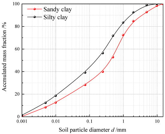
Figure 1
Open AccessArticle
Hydrochemical Characteristics and Controlling Factors of Hengshui Lake Wetland During the Dry Season, North China
by
Hongyan An, Tianjiao Wang, Xianzhou Meng, Xueyao Niu, Dongyang Song, Yibing Wang, Ge Gao, Mingming Li, Tong Zhang, Hongliang Song, Xinfeng Wang and Kuanzhen Mao
Water 2025, 17(10), 1468; https://doi.org/10.3390/w17101468 - 13 May 2025
Abstract
Wetland lakes are crucial ecosystems that serve as vital ecosystems that harbor rich biodiversity and provide essential ecological services, particularly in regulating regional water resources, purifying water quality, and maintaining ecological equilibrium. This study aims to conduct an in-depth investigation into the hydrochemical
[...] Read more.
Wetland lakes are crucial ecosystems that serve as vital ecosystems that harbor rich biodiversity and provide essential ecological services, particularly in regulating regional water resources, purifying water quality, and maintaining ecological equilibrium. This study aims to conduct an in-depth investigation into the hydrochemical characteristics and their controlling factors during the dry season of the Hengshui Lake wetland system. By collecting water samples from the lake and shallow groundwater, and using water chemistry diagrams, ion ratios, mineral saturation indices, and multivariate statistical methods, the study systematically analyzes the hydrochemical characteristics of Hengshui Lake Wetland and its controlling factors. The results show: there is significant stratified differentiation in the water chemical composition: the lake water is weakly alkaline and fresh, while the shallow groundwater is highly mineralized and saline. Both are dominated by Na+, Mg2+, SO42−, and Cl−. Significant differences exist in water chemistry types between the lake and shallow groundwater. The lake water exhibits homogenized characteristics with a dominant SO4·Cl·HCO3-Na·Mg type, whereas shallow groundwater displays five distinct hydrochemical facies indicative of multi-source recharge processes. Evaporation–rock interaction mechanisms dominate the system, as evidenced by a Gibbs diagram analysis showing evaporation crystallization as the primary control. Ion ratio calculations demonstrate synergistic effects between silicate weathering and evaporite dissolution, while mineral saturation indices confirm cooperative processes involving calcite/dolomite oversaturation and ongoing gypsum dissolution. Cation exchange indexes combined with chloro-alkaline indices reveal unidirectional recharge from lake water to shallow groundwater accompanied by active cationic exchange adsorption. Although the wetland predominantly maintains natural hydrological conditions, elevated γ(NO3−)/γ(Na+) ratios in nearshore zones suggest initial agricultural contamination infiltration. This study shows that, as a typical example of a closed wetland, the hydrochemistry evolution of Hengshui Lake during the dry season is primarily dominated by the coupled effects of evaporation and rock–water interaction, with silicate weathering and evaporation rock dissolution as secondary factors, and human activity having a weak influence. The findings provide new insights into the understanding of the hydrochemical evolution process and its controlling factors in closed lakes, offering valuable data support and theoretical basis for the ecological restoration and sustainable management of closed lakes.
Full article
(This article belongs to the Special Issue Groundwater Flow and Transport Modeling in Aquifer Systems)
Open AccessArticle
Development of Flood Early Warning Framework to Predict Flood Depths in Unmeasured Cross-Sections of Small Streams in Korea
by
Tae-Sung Cheong, Seojun Kim and Kang-Min Koo
Water 2025, 17(10), 1467; https://doi.org/10.3390/w17101467 - 13 May 2025
Abstract
Climate changes have increased heavy rainfall, intensifying flood damage, especially along small streams with steep slopes, fast flows, and narrow widths. In Korea, nearly half of flood-related casualties occur in these regions, underscoring the need for effective flood early warning systems. However, predicting
[...] Read more.
Climate changes have increased heavy rainfall, intensifying flood damage, especially along small streams with steep slopes, fast flows, and narrow widths. In Korea, nearly half of flood-related casualties occur in these regions, underscoring the need for effective flood early warning systems. However, predicting flood depths is challenging due to the complex channels and rapid flood wave propagation in small streams. This study developed a flood early warning framework (FEWF) tailored for small streams in Korea, optimizing rainfall–discharge nomographs using hydro-informatic data from four streams. The FEWF integrates a four-parameter logistic model with real-time updates with a nomograph using a robust constrained nonlinear optimization algorithm. A simplified two-level early warning system (attention and severe) is based on field-verified thresholds. Discharge predictions estimate the water depth in unmeasured cross-sections using the Manning formula, with real-time data updates allowing for the dynamic identification of the flood depth. The framework was validated during the 2022 flood event, where no inundation or bank failures were observed. By improving flood prediction and adaptive management, this framework can significantly enhance disaster response and reduce casualties in vulnerable small stream areas.
Full article
(This article belongs to the Section Hydraulics and Hydrodynamics)
Open AccessArticle
Environmental Assessment of a Heritage Forest Urban Park on the Densely Populated Coast of Versilia, Italy
by
Roberto Giannecchini, Lisa Ghezzi, Simone Arrighi, Silvia Fornasaro, Stefania Giannarelli, Alessio Pardini and Riccardo Petrini
Water 2025, 17(10), 1466; https://doi.org/10.3390/w17101466 - 13 May 2025
Abstract
The present study focuses on the sources and spatial distribution of potentially toxic elements (PTEs) and organic pollutants in water, canal bed sediment, and soil in the Versiliana urban park, an inclusive green area near the coast in the densely populated Versilia Plain
[...] Read more.
The present study focuses on the sources and spatial distribution of potentially toxic elements (PTEs) and organic pollutants in water, canal bed sediment, and soil in the Versiliana urban park, an inclusive green area near the coast in the densely populated Versilia Plain of Tuscany. Surface water and bed sediments from canals crossing the urban park were collected at 10 stations during four different surveys to account for hydrological seasonality. Groundwater was collected in a survey through 10 piezometers. Eleven shallow soil samples were also collected, with the aim of evaluating the potential release of pollutants. Groundwater ranged from Ca-HCO3, to NaCl, CaCl2, and Na-HCO3 water types, indicating conservative mixing and cation exchange processes during seawater intrusion. Most waters from canals belonged to the Ca-HCO3 hydrofacies; a salinization shift, due to hydraulic connection with saline groundwater and soil sea salt dissolution, is observed. The concentration of most PTEs in groundwater and canal water is below Italian regulatory thresholds, with the only exception being As, which exceeds the legal limit in some samples. In most sediments, Ni, Cr, Zn, and As exceed the threshold effect concentration, and in some cases, the probable effect concentration. Geogenic PTE sources are attributed to metalliferous mineralization that characterizes the upstream Versilia River basin catchment. However, local PTE inputs from vehicular emissions and local industrial activities have been highlighted. Arsenic in sediments originated from geogenic sources and from arsenical pesticides, as indicated by the analysis of organic compounds, highlighting the legacy of the use of organic pesticides that have settled in bed sediments, in particular malathion and metalaxyl. The arsenic risk-based screening level in soil is lower compared with the regulatory threshold and with the measured concentration.
Full article
(This article belongs to the Special Issue The Qualitative and Quantitative Management of Groundwater Resources in Urban Areas)
►▼
Show Figures
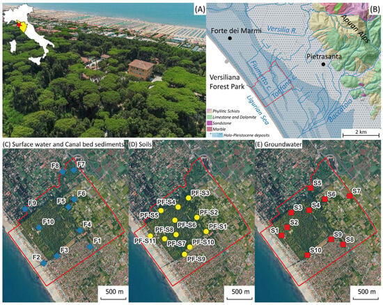
Figure 1
Open AccessArticle
LSTM-Based Runoff Forecasting Using Multiple Variables: A Case Study of the Nyang River, a Typical Basin on the Tibetan Plateau
by
Ting Chen, Zhen Liu, Zhijie Song, Jingyi Zhang, Weidong Zhao, Qiuyan Dong, Jingxuan Jiang, Li Zhou and Tianqi Ao
Water 2025, 17(10), 1465; https://doi.org/10.3390/w17101465 - 13 May 2025
Abstract
Accurate runoff forecasting is crucial for disaster prevention and mitigation, as well as water resource allocation planning. However, the accuracy of runoff forecasting in high mountain watersheds is limited by the complexity of terrain and the scarcity of observation data. In recent years,
[...] Read more.
Accurate runoff forecasting is crucial for disaster prevention and mitigation, as well as water resource allocation planning. However, the accuracy of runoff forecasting in high mountain watersheds is limited by the complexity of terrain and the scarcity of observation data. In recent years, machine learning models have been widely used for runoff prediction. In order to explore the application effect of the Long Short-Term Memory (LSTM) network in high mountain watersheds, this paper takes the Nyang River Basin (NRB) in a typical watershed on the Qinghai–Tibet Plateau (QTP) as the research object, and uses LSTM models to study the impact of different input variable combinations on runoff prediction under multiple prediction periods. The results indicate that with the extension of the forecast period, the impact of historical runoff on runoff prediction accuracy gradually decreases, while the impact of precipitation and temperature on runoff prediction accuracy gradually increases. When the forecast period exceeds 13 days, the contribution of precipitation increases more significantly. The use of historical runoff and forecasting that includes historical runoff and precipitation yields the most robust results, with good forecasting performance within 25 days of the forecast period. Moreover, the larger the watershed area, the better the runoff forecasting effect.
Full article
(This article belongs to the Section Hydrology)
►▼
Show Figures

Figure 1
Open AccessArticle
Accumulation of Nitrogen Species from Industrial Wastewater by Vetiver Grass (Chrysopogon zizanioides)
by
Arash Aliasghar, Zhiming Zhang, Rupali Datta, Christos Christodoulatos and Dibyendu Sarkar
Water 2025, 17(10), 1464; https://doi.org/10.3390/w17101464 - 13 May 2025
Abstract
Industrial munition facilities are increasingly manufacturing insensitive high explosives (IHEs) to improve safety. The explosive residues in wastewater from these facilities are treated to meet regulatory standards. However, the resulting effluent contains elevated levels of mineralized nitrogen species. This study evaluated the potential
[...] Read more.
Industrial munition facilities are increasingly manufacturing insensitive high explosives (IHEs) to improve safety. The explosive residues in wastewater from these facilities are treated to meet regulatory standards. However, the resulting effluent contains elevated levels of mineralized nitrogen species. This study evaluated the potential of vetiver grass (Chrysopogon zizanioides), a non-invasive perennial species, to remove high concentrations of nitrate, nitrite, and ammonium from munition plant wastewater. Vetiver was grown hydroponically in synthetic wastewater containing high levels of nitrogen compounds simulating munitions plant effluents. Vetiver plants were treated with one nitrogen species at a time, with concentrations ranging from 165 to 24,700 mg N/L of nitrate, 100 to 4000 mg N/L of nitrite, and 260 to 39,000 mg N/L of ammonium. Nitrogen concentrations in the media and plant responses were monitored over time. The results showed significant nitrogen removal at lower concentration ranges. When concentrations exceeded 3800 mg N/L of nitrate, 800 mg N/L of nitrite, and 2600 mg N/L of ammonium, the removal rates declined after 7 days. At higher nitrogen levels, vetiver exhibited stress symptoms such as chlorosis and elevated antioxidant enzyme activity. Our study demonstrates the potential of vetiver grass in treating nitrogen-rich wastewater from the munition industry and provides a baseline for future large-scale studies to optimize the technology.
Full article
(This article belongs to the Section Wastewater Treatment and Reuse)
►▼
Show Figures
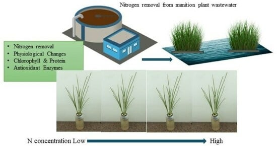
Graphical abstract
Open AccessArticle
Transboundary Urban Basin Analysis Using GIS and RST for Water Sustainability in Arid Regions
by
A A Alazba, Amr Mosad, Hatim M. E. Geli, Ahmed El-Shafei, Mahmoud Ezzeldin, Nasser Alrdyan and Farid Radwan
Water 2025, 17(10), 1463; https://doi.org/10.3390/w17101463 - 12 May 2025
Abstract
Water, often described as the elixir of life, is a critical resource that sustains life on Earth. The acute water scarcity in the major basins of the Arabian Peninsula has been further aggravated by rapid population growth, urbanization, and the impacts of climate
[...] Read more.
Water, often described as the elixir of life, is a critical resource that sustains life on Earth. The acute water scarcity in the major basins of the Arabian Peninsula has been further aggravated by rapid population growth, urbanization, and the impacts of climate change. This situation underscores the urgent need for a comprehensive analysis of the region’s morphometric characteristics. Such an analysis is essential for informed decision-making in water resource management, infrastructure development, and conservation efforts. This study provides a foundational basis for implementing sustainable water management strategies and preserving ecological systems by deepening the understanding of the unique hydrological processes within the Arabian Peninsula. Additionally, this research offers valuable insights to policymakers for developing effective flood mitigation strategies by identifying vulnerable areas. The study focuses on an extensive investigation and assessment of morphometric parameters in the primary basins of the Arabian Peninsula, emphasizing their critical role in addressing water scarcity and promoting sustainable water management practices. The findings reveal that the Arabian Peninsula comprises 12 major basins, collectively forming a seventh-order drainage system and covering a total land area of 3.24 million km2. Statistical analysis demonstrates a strong correlation between stream order and cumulative stream length, as well as a negative correlation between stream order and stream number (R2 = 99%). Further analysis indicates that many of these basins exhibit a high bifurcation ratio, suggesting the presence of impermeable rocks and steep slopes. The hypsometric integral (HI) of the Peninsula is calculated to be 60%, with an erosion integral (EI) of 40%, indicating that the basin is in a mature stage of geomorphological development. Importantly, the region is characterized by a predominantly coarse drainage texture, limited infiltration, significant surface runoff, and steep slopes, all of which have critical implications for water resource management.
Full article
(This article belongs to the Section Water Resources Management, Policy and Governance)
►▼
Show Figures
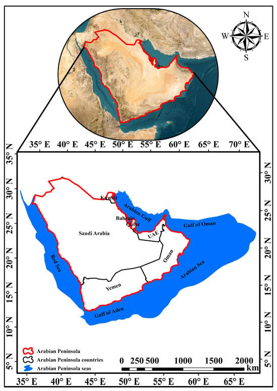
Figure 1
Open AccessArticle
Identification and Ranking of Human Resource-Related Risks Considering Secondary and Residual Risks in Water Transfer Projects Using the DEMATEL–MARCOS Method
by
Mohammad Khalilzadeh, Sayyid Ali Banihashemi, Adis Puška, Aleksandar Milić and Darko Božanić
Water 2025, 17(10), 1462; https://doi.org/10.3390/w17101462 - 12 May 2025
Abstract
In competitive organizations and projects, assessing risks related to human capital is essential for improving workplace conditions and ensuring project success. This study evaluates primary, secondary, and residual human capital risks in urban water transfer projects using an innovative hybrid DEMATEL–MARCOS approach. The
[...] Read more.
In competitive organizations and projects, assessing risks related to human capital is essential for improving workplace conditions and ensuring project success. This study evaluates primary, secondary, and residual human capital risks in urban water transfer projects using an innovative hybrid DEMATEL–MARCOS approach. The DEMATEL method was employed to analyze causal relationships and interdependencies among risks, while the MARCOS method ranked their significance. The key findings reveal that “accidents during material transportation” (primary risk), “corrosion” (secondary risk), and “pipeline pressure” (residual risk) are the most critical factors influencing human capital in such projects. The study provides a structured framework for prioritizing risk mitigation strategies, offering actionable insights for policymakers and project managers to enhance safety, efficiency, and workforce well-being. By integrating multi-criteria decision-making techniques, this research bridges a gap in the water industry’s risk management practices and contributes to safer, more sustainable infrastructure development.
Full article
(This article belongs to the Special Issue Optimization-Simulation Modeling of Sustainable Water Resource)
►▼
Show Figures

Figure 1
Open AccessArticle
Optimization and Evaluation of Wetland Ecological Networks for Mitigating Urban Flooding
by
Haoyu Tong, Yonghong Cao and Yue Zhang
Water 2025, 17(10), 1461; https://doi.org/10.3390/w17101461 - 12 May 2025
Abstract
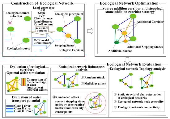
Innovative solutions are needed for urban flooding exacerbated by climate change. In light of this, this study developed an integrated framework for urban wetland flood control that combines Morphospatial Pattern Analysis (MSPA), minimum cumulative resistance (MCR) modeling, and complex network theory for optimizing
[...] Read more.
Innovative solutions are needed for urban flooding exacerbated by climate change. In light of this, this study developed an integrated framework for urban wetland flood control that combines Morphospatial Pattern Analysis (MSPA), minimum cumulative resistance (MCR) modeling, and complex network theory for optimizing an ecological network of flood control and mitigation wetlands in Changchun, China. The results show that the optimized ecological network significantly improved connectivity and flood mitigation efficiency. The node degree increased from 2.737 to 3.433, and the average clustering coefficient exhibited an increase from 0.074 to 0.231, enhancing material flow efficiency. Robustness analysis revealed that the optimized network’s connectivity robustness improved by 12.6%, 18.4%, and 24.1% under random, malicious, and controlled attack scenarios, respectively. Additionally, ecological corridors with a width of 30–50 m were identified as the optimal range for water conveyance potential, effectively dispersing peak runoff and reducing flood risk. This study provides both a transferable methodology for flood-resilient planning and specific policy actions, including priority conservation of high-betweenness nodes and restoration of fragmented wetlands, offering practical solutions for high-density cities facing similar climate challenges.
Full article
(This article belongs to the Special Issue Ecohydrological Processes, Environmental Effects, and Integrated Regulation of Wetland Ecosystems, 3rd Edition)
►▼
Show Figures
Graphical abstract
Open AccessArticle
Analysis of Shoreline Change in Huizhou–Shanwei Region (China) from 1990 to 2023
by
Sizheng Li, Feng Gui, Jirong Feng, Yang Wang, Yanwei Song, Wanhu Wang and Cong Lin
Water 2025, 17(10), 1460; https://doi.org/10.3390/w17101460 - 12 May 2025
Abstract
The dynamic change in the shorelines reflects an important sign to the socio-economic development of coastal areas. The Huizhou–Shanwei region of China has experienced rapid socio-economic development over the past 33 years. The study of the dynamic change in the shorelines in this
[...] Read more.
The dynamic change in the shorelines reflects an important sign to the socio-economic development of coastal areas. The Huizhou–Shanwei region of China has experienced rapid socio-economic development over the past 33 years. The study of the dynamic change in the shorelines in this region can provide basic data support for the marine environmental protection and regional development planning in this region. Based on Landsat RS (remote sensing) images from 1990 to 2023, this study obtained the length and structure data of the shorelines in eight periods by manual visual interpretation. DSAS (Digital Shoreline Analysis System) and other methods were also used to calculate indices such as EPR (End Point Rate) and fractal dimension of the shorelines The results show that, during 33 years, the length of the shorelines increased 15.83 km, with an average growth rate of 0.48 km/y; the value of the intensity of change in the shorelines was 0.08%; the average EPR was 3.66 (m/y), and the artificiality index of the shorelines increased from 0.2895 to 0.4295; the greatest intensity of change was in the estuarine shorelines, with an intensity of change of −2.69%. The overall change in the fractal dimension of the shorelines was small, both between 1.0395 and 1.0673; the shorelines became slightly more curved. As far as the influencing factors are concerned, the influence of the natural environment is a long process, and human activities are more capable of changing the length and shape of the shorelines in a short period of time, with factors such as the degree of economic development having a greater impact on the shorelines.
Full article
(This article belongs to the Special Issue Advanced Research on Marine Geology and Sedimentology)
►▼
Show Figures
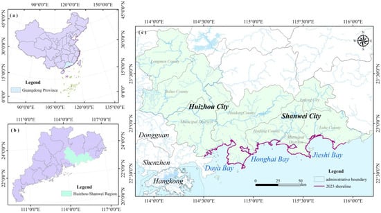
Figure 1
Open AccessArticle
The Hydrogeochemical Characteristics and Formation Mechanisms of the High-Salinity Groundwater in Yuheng Mining Area of the Jurassic Coalfield, Northern Shaanxi, China
by
Yuanhong Han, Hongchao Zhao, Yongtao Ji, Yue Wang and Liwei Zhang
Water 2025, 17(10), 1459; https://doi.org/10.3390/w17101459 - 12 May 2025
Abstract
In the Yuheng mining area (Jurassic coalfield, northern Shaanxi, China), the Yan’an Formation groundwater is characterized by elevated salinity, posing challenges for mine water pollution control and regional water resource management. However, the spatial distribution patterns and formation mechanisms of this high-salinity groundwater
[...] Read more.
In the Yuheng mining area (Jurassic coalfield, northern Shaanxi, China), the Yan’an Formation groundwater is characterized by elevated salinity, posing challenges for mine water pollution control and regional water resource management. However, the spatial distribution patterns and formation mechanisms of this high-salinity groundwater remain poorly studied. This study integrates hydrogeochemical data from 18 coal mines, analyzing the spatial salinity variations, major ion compositions and isotopic signatures. Combined with the evolution characteristics of ancient sedimentary environments and the composition analysis of rock salt minerals in the coal rock interlayers, the formation mechanism of high salinity water was explored. The results indicate that the groundwater mineralization degree of the Yan’an Formation in the Jurassic strata encountered in the Yuheng mining area is the highest, showing a decreasing trend upwards. On the plane, the western and northern regions are generally higher than the eastern and southern regions. The highest mineralization level of groundwater can reach 36.25g/L, and the high mineralization hydrochemical type is mainly SO4-Na·Ca type, with occasional Cl-Na type in areas with extremely high mineralization level. The cause analysis shows that the highly mineralized groundwater in the Yuheng mining area comes from atmospheric precipitation, which infiltrates and dissolves salt rocks. In addition, the mining area is located in the arid area of northern Shaanxi, with insufficient water supply and no obvious structural faults, and has good sealing properties, thus exhibiting the characteristics of high mineralization. These mechanisms provide a formation model for the high-salinity groundwater in Jurassic coal-bearing strata, offering critical implications for predictive hydrogeochemical modeling and sustainable water management in arid mining regions.
Full article
(This article belongs to the Section Hydrogeology)
►▼
Show Figures

Figure 1
Open AccessArticle
Exploring the Ecological Effectiveness of Taiwan’s Ecological Check and Identification Mechanism in Coastal Engineering
by
Yu-Te Wei, Hung-Yu Chou and Yu-Ting Lai
Water 2025, 17(10), 1458; https://doi.org/10.3390/w17101458 - 12 May 2025
Abstract
Extreme weather events from climate change challenge infrastructure stability. While water-related engineering enhances disaster resilience, it also impacts ecosystems. Taiwan has implemented Ecological Check and Identification (ECI) since 2003, yet challenges remain in standards, resource allocation, and effectiveness. This study analyzes 35 coastal
[...] Read more.
Extreme weather events from climate change challenge infrastructure stability. While water-related engineering enhances disaster resilience, it also impacts ecosystems. Taiwan has implemented Ecological Check and Identification (ECI) since 2003, yet challenges remain in standards, resource allocation, and effectiveness. This study analyzes 35 coastal engineering cases and participated in two engineering projects from five key perspectives. The results show that there are regional differences in the types of projects implemented for ECI. Landscape engineering was the main type in northern Taiwan (31%), water resource engineering was the main type in southern Taiwan (43%), and no cases were found in eastern Taiwan. Most inspections occur in the proposal (24%), planning (22%), and design (22%) stages, with limited post-construction monitoring (14%). Furthermore, ecological assessments were lacking in 49% of cases, and aquatic ecosystems were underrepresented. Inconsistent inspection formats and low species documentation (57% of cases) reduce data comparability and conservation effectiveness. To address these gaps, some recommendations were made, including standardizing inspections, integrating Sustainable Development Goals (SDGs), promoting low-carbon approaches, strengthening public participation, and establishing long-term monitoring. The findings provide policy insights to enhance ECI, supporting sustainable coastal engineering while balancing infrastructure benefits and environmental conservation.
Full article
(This article belongs to the Special Issue Coastal Ecology and Fisheries Management)
►▼
Show Figures
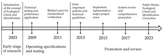
Figure 1
Open AccessArticle
Evolution of a Potentially Dangerous Glacial Lake on the Kanchenjunga Glacier, Nepal, Predictive Flood Models, and Prospective Community Response
by
Alton C. Byers, Sonam Rinzin, Elizabeth Byers and Sonam Wangchuk
Water 2025, 17(10), 1457; https://doi.org/10.3390/w17101457 - 12 May 2025
Abstract
During a research expedition to the Kanchenjunga Conservation Area (KCA), eastern Nepal, in April–June 2024, local concern was expressed about the rapid development of meltwater ponds upon the terminus of the Kanchenjunga glacier since 2020, especially in terms of the possible formation of
[...] Read more.
During a research expedition to the Kanchenjunga Conservation Area (KCA), eastern Nepal, in April–June 2024, local concern was expressed about the rapid development of meltwater ponds upon the terminus of the Kanchenjunga glacier since 2020, especially in terms of the possible formation of a large and potentially dangerous glacial lake. Our resultant study of the issue included informal interviews with local informants, comparison of time series satellite composite images acquired by Sentinel-2 Multispectral Instrument, and modeling of different lake development, outburst flood scenarios, and prospective downstream impacts. Assuming that the future glacial lake will be formed by the merging of present-day supraglacial ponds, filling the low-gradient area beneath the present-day glacier terminal complex, we estimated the potential volume of a Kanchenjunga proglacial lake to be 33 × 106 m3. Potential mass movement-triggered outburst floods would travel downstream distances of almost 120 km even under the small magnitude scenario, and under the worst-case scenario would reach the Indo-Gangetic Plain and cross the border into India, exposing up to 90 buildings and 44 bridges. In response, we suggest that the lower Kanchenjunga glacier region be regularly monitored by both local communities and Kathmandu-based research entities over the next decade. The development of user-friendly early warning systems, hazard mapping and zoning programs, cryospheric hazards awareness building programs, and construction of locally appropriate flood mitigation measures are recommended. Finally, the continued development and refinement of the models presented here could provide governments and remote communities with a set of inexpensive and reliable tools capable of providing the basic information needed for communities to make informed decisions regarding hazard mitigation, adaptive, and/or preventive measures related to changing glaciers.
Full article
(This article belongs to the Special Issue Study of Hydrological Mechanisms: Floods and Landslides)
Open AccessArticle
Spatial–Temporal Evolution of Agricultural Water Use Efficiency Based on DEA Approach and Spatial Autocorrelation
by
Litao Huo, Ruitao Jia, Sa Wei, Meijing Chen, Qingqing Ma, Tengfei Jia, Jiawei Sun and Zonglin Han
Water 2025, 17(10), 1456; https://doi.org/10.3390/w17101456 - 12 May 2025
Abstract
With the change in climate and rapid social development, the problems of low agricultural water resource utilization efficiency (AWUE) and significant spatiotemporal variability in the Hebei Province of China are becoming increasingly prominent. This paper constructed a framework that considers environmental exogenous variables
[...] Read more.
With the change in climate and rapid social development, the problems of low agricultural water resource utilization efficiency (AWUE) and significant spatiotemporal variability in the Hebei Province of China are becoming increasingly prominent. This paper constructed a framework that considers environmental exogenous variables and selects evaluation indicators based on the Lasso model. It also used the Data Envelopment Analysis (DEA) model to measure AWUE from 2012 to 2021. Furthermore, the Global Moran’s Index (GMI) and Getis Ord Gi * Index (GOGI) were applied to explore characteristics and trends of the spatiotemporal of AWUE. The conclusions are as follows: (1) The AWUE showed a fluctuating development trend of first rising and then falling. However, it did not achieve the effectiveness of DEA in general, and AWUE still had the potential and room for improvement. (2) From the perspective of spatiotemporal variability of AWUE, the northeast region shows better performance than the southwest region. The AWUE among cities and areas had a significant but relatively loose spatial correlation. (3) From 2012 to 2021, the centroid distribution of AWUE hotspots showed a shift from central areas to northeast, with an average annual transfer distance of 11.14 km. In summary, this study emphasizes the urgent need to improve AWUE, which can provide a reference for water resources departments to formulate policy planning and management decisions tailored to local conditions.
Full article
(This article belongs to the Special Issue Methods and Tools for Sustainable Agricultural Water Management)
►▼
Show Figures
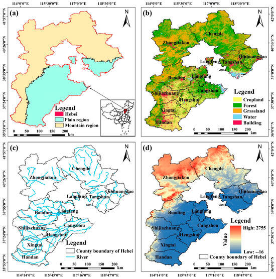
Figure 1
Open AccessArticle
A Bibliometric Review of Environmental Pollution Research in Major Global Gulfs
by
Daoyuan Jiang, Qiao Yang, Yang Fang, Xiaoling Zhang and Jing Song
Water 2025, 17(10), 1455; https://doi.org/10.3390/w17101455 - 12 May 2025
Abstract
Major global gulfs are essential for economic development but remain highly vulnerable to environmental pollutants. Despite progress in gulf environmental research, the extent of research investment in gulf environments across different regions worldwide remains unclear, which hinders the development of a unified global
[...] Read more.
Major global gulfs are essential for economic development but remain highly vulnerable to environmental pollutants. Despite progress in gulf environmental research, the extent of research investment in gulf environments across different regions worldwide remains unclear, which hinders the development of a unified global framework for bay environmental management. We aim to fill this gap by integrating GIS and Python-based methods to identify the ten largest gulfs globally and conducting a statistical analysis of research publications from 2000 to 2024 for these gulfs, based on the Web of Science core database. We find that the publication numbers show a correlation with the size of the gulf. However, the Gulf of Mexico and the Gulf of St. Lawrence show higher publication volumes, likely influenced by economic activities and major environmental incidents. In contrast, regions such as Hudson Bay and the Gulf of Carpentaria receive relatively less research attention. This suggests that scientific output in gulf regions may be attributed to economic activities and significant environmental events. Water quality research predominates, while sediment studies, particularly in high-latitude gulf areas (such as Hudson Bay), account for the lowest proportion, possibly due to sampling costs and challenges. Traditional pollutants, especially heavy metals (HMs) and persistent organic pollutants (POPs), are the primary focus of research. The investigation of emerging contaminants reveals significant regional disparities, emphasizing the necessity for further research and enhanced regulatory frameworks. This study provides scientific evidence for the unified governance of gulf environments.
Full article
(This article belongs to the Section Oceans and Coastal Zones)
►▼
Show Figures
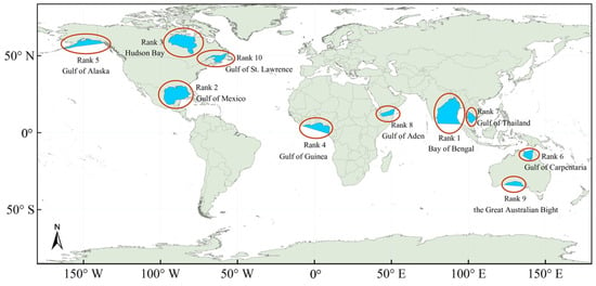
Figure 1
Open AccessEditorial
Transient Flows: Mathematical Models, Laboratory Tests, Protection Elements and Systems
by
Vicente S. Fuertes-Miquel
Water 2025, 17(10), 1454; https://doi.org/10.3390/w17101454 - 12 May 2025
Abstract
Transient flows represent a critical topic in the field of hydraulic engineering, one that has witnessed significant progress in recent decades [...]
Full article
(This article belongs to the Special Issue Transient Flows: Mathematical Models, Laboratory Tests, Protection Elements and Systems)
Open AccessEditorial
Impact of Environmental Factors on Aquatic Ecosystem
by
Xuan Ban, Wenxian Guo and Yicheng Fu
Water 2025, 17(10), 1453; https://doi.org/10.3390/w17101453 - 12 May 2025
Abstract
Aquatic ecosystems are facing unprecedented challenges due to anthropogenic activities and climate change [...]
Full article
(This article belongs to the Special Issue Impact of Environmental Factors on Aquatic Ecosystem)

Journal Menu
► ▼ Journal Menu-
- Water Home
- Aims & Scope
- Editorial Board
- Reviewer Board
- Topical Advisory Panel
- Instructions for Authors
- Special Issues
- Topics
- Sections & Collections
- Article Processing Charge
- Indexing & Archiving
- Editor’s Choice Articles
- Most Cited & Viewed
- Journal Statistics
- Journal History
- Journal Awards
- Society Collaborations
- Conferences
- Editorial Office
Journal Browser
► ▼ Journal BrowserHighly Accessed Articles
Latest Books
E-Mail Alert
News
Topics
Topic in
Clean Technol., Membranes, Nanomaterials, Sustainability, Water
Removing Challenging Pollutants from Wastewater: Effective Approaches
Topic Editors: Shuting Zhuang, Jiang-Bo Huo, Suping YuDeadline: 31 May 2025
Topic in
Environments, Hydrology, Sustainability, Water
Critical Issues in Groundwater Pollution Monitoring and Risk Warning
Topic Editors: Wenjing Zhang, Wenxia Wei, Huan Huan, Zhi Dou, Yuanzheng ZhaiDeadline: 30 June 2025
Topic in
Agronomy, Climate, Earth, Remote Sensing, Water
Advances in Crop Simulation Modelling
Topic Editors: Mavromatis Theodoros, Thomas Alexandridis, Vassilis AschonitisDeadline: 15 July 2025
Topic in
Molecules, Separations, Sustainability, Water, Minerals
Analysis and Separations of Trace Elements in the Environment
Topic Editors: Gene Hall, Begoña GonzálezDeadline: 31 July 2025

Conferences
Special Issues
Special Issue in
Water
The Role of Vegetation in Freshwater Ecology
Guest Editors: Josef Křeček, Moshe Gophen, Hans SchreierDeadline: 15 May 2025
Special Issue in
Water
Impact of Microplastics on Aquatic Ecosystems
Guest Editors: Jian Liu, Changchao LiDeadline: 15 May 2025
Special Issue in
Water
Hydroclimate Extremes: Causes, Impacts, and Mitigation Plans
Guest Editors: Masoud Irannezhad, Anna-Kaisa RonkanenDeadline: 15 May 2025
Special Issue in
Water
Applications of Microalgae and Macroalgae in Water Treatment
Guest Editors: Changliang Nie, Chenxi MiDeadline: 15 May 2025


