Next Issue
Volume 16, May-1
Previous Issue
Volume 16, April-1


Water, Volume 16, Issue 8 (April-2 2024) – 122 articles

Cover Story (view full-size image): 
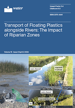
This study examines the transport of floating macro-plastics in fluvial systems, focusing on the influence of characteristics of the riparian zone, such as the density and arrangement of riverbank vegetation. Using flume experiments and particle tracking velocimetry, the transport velocities of macro-plastics of different sizes and shapes were measured. The results indicate that plastics away from vegetated riverbanks move up to nine times faster than those within. Dense vegetation can reduce transport velocity threefold, sometimes trapping plastics within it. These findings can guide riparian vegetation management to enhance macro-plastic trapping efficiency, considering different flow conditions and river morphologies. View this paper
  • Issues are regarded as officially published after their release is announced to the table of contents alert mailing list.
  • You may sign up for e-mail alerts to receive table of contents of newly released issues.
  • PDF is the official format for papers published in both, html and pdf forms. To view the papers in pdf format, click on the "PDF Full-text" link, and use the free Adobe Reader to open them.
Order results
Result details
Section
Select all
Export citation of selected articles as:
10 pages, 946 KiB  
Communication
Comparative Inactivation of the RNA of the Delta and Omicron Variants of SARS-CoV-2 in Wastewater of Five Municipalities in Southeast Germany
by Michael Geissler and Roger Dumke
Water 2024, 16(8), 1193; https://doi.org/10.3390/w16081193 - 22 Apr 2024
Viewed by 456
Abstract
During the COVID-19 pandemic, wastewater-based epidemiology has been extensively used as a helpful tool for evaluation of the epidemic situation in catchments of wastewater treatment plants. In this context, knowledge about the rate of virus inactivation in wastewater is important for characterization of [...] Read more.
During the COVID-19 pandemic, wastewater-based epidemiology has been extensively used as a helpful tool for evaluation of the epidemic situation in catchments of wastewater treatment plants. In this context, knowledge about the rate of virus inactivation in wastewater is important for characterization of the influence of retention times in sewers on virus concentrations, of the storage periods before analysis in the laboratory, on virus elimination during treatment and for modeling approaches. In the present study, we genotyped SARS-CoV-2 in the respiratory tract specimens of infected patients and spiked the raw wastewater of five treatment plants with aliquots of these samples. The test preparations were incubated under practically relevant temperature conditions (14 °C) over 31 days. The linear decay rates resulted in comparable T90 values (30.5 d) for the Delta and the Omicron BA1 variants of SARS-CoV-2 without differences in using the E or S gene of the virus as the target for amplification. In contrast, the origin of wastewater influenced the inactivation rate of both variants significantly, with the mean T90 values varying between 24.3 and 53.1 days in the wastewater from the five plants. The data suggest that the inactivation rate of SARS-CoV-2 in wastewater is more strongly determined by the composition of the water than by the virus variant. Full article
(This article belongs to the Section Water Quality and Contamination)
Show Figures

Figure 1

15 pages, 1747 KiB  
Article
Study on the Synergistic Effects of Karst Carbon Sink and Vegetation Carbon Sink in Watersheds under Different Geological Backgrounds—A Case Study of Darongjiang and Lingqu Watersheds
by Xue Wang, Xiangling Tang, Shi Yu and Xuemei Zhong
Water 2024, 16(8), 1192; https://doi.org/10.3390/w16081192 - 22 Apr 2024
Viewed by 408
Abstract
In this study, the hydrochemistry-runoff method and remote sensing estimation method were used to calculate the karst carbon sink flux (KCSF) and the forest vegetation carbon sequestration flux (FVCSF) in Darongjiang (DRJ) and Lingqu (LQ) watersheds. The results show the following: (1) The [...] Read more.
In this study, the hydrochemistry-runoff method and remote sensing estimation method were used to calculate the karst carbon sink flux (KCSF) and the forest vegetation carbon sequestration flux (FVCSF) in Darongjiang (DRJ) and Lingqu (LQ) watersheds. The results show the following: (1) The KCSF in DRJ and LQ watersheds is 238.43 × 10⁵ t·y−1 and 353.44 × 10⁵ t·y−1, respectively. Influenced by changes in flow rate, the two watersheds both show that their KCSF is higher in the rainy season than in the dry season. (2) The FVCSF in DRJ and LQ watersheds was 680.78 × 10⁷ t·y−1 and 229.63 × 10⁷ t·y−1, respectively. Through comparison, it can be seen that the FVCSF is much higher than the KCSF in both watersheds, but the FVCSF and the KCSF are at the same order of magnitude. (3) Through further analysis of the influence factors on the FVCSF and the KCSF, we found that the highest values of FVCSF are mainly distributed around Kitten Mountain on the upper reach and along the LQ watershed. That may be because most of the upper reach areas are mountainous forestland, and the strong weathering of rocks in the LQ watershed promotes the development of forest vegetation carbon sequestration. Therefore, it can be inferred that there is a certain synergistic effect between the karst carbon sink (KCS) and the forest vegetation carbon sequestration (FVCS) in the study area, and such a synergistic effect is caused by rock weathering. Full article
Show Figures

Figure 1

13 pages, 2921 KiB  
Article
Added Biochars Promoted Nitrogen and Phosphorus Removal from Ecological Ditches at Low Temperature
by Guangsha Bai, Si Pang, Dongsu Bi, Siqi Wang, Min Cai, Lingqi Kong, Zheng Shen and Yalei Zhang
Water 2024, 16(8), 1191; https://doi.org/10.3390/w16081191 - 22 Apr 2024
Viewed by 418
Abstract
The global issue of ecological ditches being poor in removing nitrogen and phosphorus under cold winter temperatures has been identified. This study introduced three types of biochar (reed, rice, and corn) into ecological ditch sediments via two application methods: rhizosphere and mixed addition. [...] Read more.
The global issue of ecological ditches being poor in removing nitrogen and phosphorus under cold winter temperatures has been identified. This study introduced three types of biochar (reed, rice, and corn) into ecological ditch sediments via two application methods: rhizosphere and mixed addition. The purpose was to explore how these methods affect the removal of nitrogen and phosphorus, as well as their influences on microbial communities in sediments. The results indicated that the addition of biochar to ecological ditches significantly enhanced the removal of nitrogen and phosphorus. Among the three types of biochar, the mixed addition of corn biochar yielded the greatest results, achieving removal rates of 77.1% for total nitrogen (TN), 93.3% for NH4+-N, and 90.3% for total phosphorus (TP). The growth of Vallisneria natans was greatly improved by the mixed addition method, resulting in an average increase of 154%. This improvement was superior to the rhizosphere addition group, which led to a growth increase of 125%. In comparison, the control group (CK) showed a decrease of 4.8% in growth. Different methods of biochar addition resulted in changes in the physicochemical properties and stoichiometry of the plants. Microbial analyses showed that the addition of biochar reduced the diversity and abundance of the substrate microbial community. Full article
Show Figures

Graphical abstract

21 pages, 4735 KiB  
Article
Safety Monitoring Method for the Uplift Pressure of Concrete Dams Based on Optimized Spatiotemporal Clustering and the Bayesian Panel Vector Autoregressive Model
by Lin Cheng, Jiaxun Han, Chunhui Ma and Jie Yang
Water 2024, 16(8), 1190; https://doi.org/10.3390/w16081190 - 22 Apr 2024
Viewed by 385
Abstract
To establish a safety monitoring method for the uplift pressure of concrete dams, spatiotemporal information from monitoring data is needed. In the present study, the method of ordering points to identify the clustering structure is employed to spatially cluster the uplift pressure measuring [...] Read more.
To establish a safety monitoring method for the uplift pressure of concrete dams, spatiotemporal information from monitoring data is needed. In the present study, the method of ordering points to identify the clustering structure is employed to spatially cluster the uplift pressure measuring points at different locations on the dam; three distance indexes and two clustering evaluation indexes are used to realize clustering optimization and select the optimal clustering results. The Bayesian panel vector autoregressive model is used to establish the uplift stress safety monitoring model for each category of monitoring point. For a nonstationary sequence, the difference method is selected to ensure that the sequence is stable, and the prediction is carried out according to the presence or absence of exogenous variables. The result is that the addition of exogenous variables increases the accuracy of the model’s forecast. Engineering examples show that the uplift pressure measurement points on the dam are divided into seven categories, and classification is based mainly on location and influencing factors. The multiple correlation coefficients of the training set and test set data of the BPVAR model are more than 0.80, and the prediction error of the validation set is lower than that of the Back Propagation neural network, XGBoost algorithm, and Support Vector Machines. The research in this paper provides some reference for seepage monitoring of concrete dams. Full article
Show Figures

Figure 1

40 pages, 9564 KiB  
Article
Groundwater Sustainability and Land Subsidence in California’s Central Valley
by Claudia C. Faunt, Jonathan A. Traum, Scott E. Boyce, Whitney A. Seymour, Elizabeth R. Jachens, Justin T. Brandt, Michelle Sneed, Sandra Bond and Marina F. Marcelli
Water 2024, 16(8), 1189; https://doi.org/10.3390/w16081189 - 22 Apr 2024
Viewed by 1881
Abstract
The Central Valley of California is one of the most prolific agricultural regions in the world. Agriculture is reliant on the conjunctive use of surface-water and groundwater. The lack of available surface-water and land-use changes have led to pumping-induced groundwater-level and storage declines, [...] Read more.
The Central Valley of California is one of the most prolific agricultural regions in the world. Agriculture is reliant on the conjunctive use of surface-water and groundwater. The lack of available surface-water and land-use changes have led to pumping-induced groundwater-level and storage declines, land subsidence, changes to streamflow and the environment, and the degradation of water quality. As a result, in part, the Sustainable Groundwater Management Act (SGMA) was developed. An examination of the components of SGMA and contextualizing regional model applications within the SGMA framework was undertaken to better understand and quantify many of the components of SGMA. Specifically, the U.S. Geological Survey (USGS) updated the Central Valley Hydrologic Model (CVHM) to assess hydrologic system responses to climatic variation, surface-water availability, land-use changes, and groundwater pumping. MODFLOW-OWHM has been enhanced to simulate the timing of land subsidence and attribute its inelastic and elastic portions. In addition to extending CVHM through 2019, the new version, CVHM2, includes several enhancements as follows: managed aquifer recharge (MAR), pumping with multi-aquifer wells, inflows from ungauged watersheds, and more detailed water-balance subregions, streamflow network, diversions, tile drains, land use, aquifer properties, and groundwater level and land subsidence observations. Combined with historical approximations, CVHM2 estimates approximately 158 km3 of storage loss in the Central Valley from pre-development to 2019. About 15% of the total storage loss is permanent loss of storage from subsidence that has caused damage to infrastructure. Climate extremes will likely complicate the efforts of water managers to store more water in the ground. CVHM2 can provide data in the form of aggregated input datasets, simulate climatic variations and changes, land-use changes or water management scenarios, and resulting changes in groundwater levels, storage, and land subsidence to assist decision-makers in the conjunctive management of water supplies. Full article
Show Figures

Figure 1

28 pages, 12078 KiB  
Article
Water Budget for Lake Trafford, a Natural Subtropical Lake in South Florida: An Example of Enhanced Groundwater Influx in a Subtropical Lake Subsequent to Organic Sediment Dredging
by Serge Thomas, Mark A. Lucius, Jong-Yeop Kim, Edwin M. Everham III, Dana L. Dettmar and Thomas M. Missimer
Water 2024, 16(8), 1188; https://doi.org/10.3390/w16081188 - 22 Apr 2024
Viewed by 335
Abstract
A very detailed water budget analysis was conducted on Lake Trafford in South Florida. The inflow was dominated by surface water influx via five canals (61%), with groundwater influx constituting 12% and direct rainfall constituting 27%. Lake discharge was dominated by sheet flow [...] Read more.
A very detailed water budget analysis was conducted on Lake Trafford in South Florida. The inflow was dominated by surface water influx via five canals (61%), with groundwater influx constituting 12% and direct rainfall constituting 27%. Lake discharge was dominated by sheet flow (69%) and evapotranspiration (30.5%), with groundwater recharge of the hydraulically connected unconfined aquifer accounting for only 0.5%. The removal of 30 M tons (4.4 × 10⁶ m3) of organic sediment impacted the groundwater influx, causing enhanced groundwater flow into the deeper parts of the lake and mixed flow along the banks, creating a rather unusual pattern. The large number of groundwater seepage meters used during this investigation led to a very reliable set of measurements with occasional failure of only a few meters. A distinctive relationship was found between the wet-season lake stage, heavy rainfall events, and pulses of exiting sheet flow from the lake. Estimation of the evapotranspiration loss using data collected from a weather station on the lake allowed the use of three different models, which, when averaged, produced results comparable to Lake Okeechobee (South Florida). A limitation of this investigation was the inability to directly measure sheet-flow discharges, which had to be estimated as a residual within the calculated water budget. Full article
(This article belongs to the Special Issue Research on Nutrient Dynamics in Lakes)
Show Figures

Figure 1

25 pages, 575 KiB  
Review
Drought in the Po Valley: Identification, Impacts and Strategies to Manage the Events
by Beatrice Monteleone and Iolanda Borzí
Water 2024, 16(8), 1187; https://doi.org/10.3390/w16081187 - 22 Apr 2024
Viewed by 454
Abstract
The area surrounding the Po River, known as the Po Valley, provides a central contribution in the economy of Italy and is highly devoted to agriculture. Recently it has been hit by multiple droughts, among which the exceptional event of summer 2022 is [...] Read more.
The area surrounding the Po River, known as the Po Valley, provides a central contribution in the economy of Italy and is highly devoted to agriculture. Recently it has been hit by multiple droughts, among which the exceptional event of summer 2022 is considered the worst dry period of the past 200 years. In the near future, the frequency of such exceptional events is predicted to rise; thus, a deep knowledge of the past droughts that hit the area, the variables used to characterize the events, the impacts they caused and the mitigation strategies adopted to deal with dry periods is of the utmost importance for policy definitions and planning. This study maps the scientific literature published from 2000 to February 2024 on the topic of drought in the Po Valley using the Scopus and Web of Science databases. Overall, 44 articles have been identified and grouped in three main classes: event identification and characterization, impact analysis and management strategies. The main gaps found in the collected papers are the lack of evaluations of the impacts of drought events on human health, hydroelectric energy production and tourism. Furthermore, comprehensive drought management and planning in the area is never addressed in the considered articles. The mentioned aspects deserve more attention, especially the development of drought management plans and policies and the evaluation of their effectiveness. Full article
(This article belongs to the Section Water and Climate Change)
Show Figures

Figure 1

15 pages, 7289 KiB  
Article
Tree-Ring Inferred Drought Variations in the Source Region of the Yangtze, Yellow, and Mekong Rivers over the Past Five Centuries
by Pei Xing, Mengxin Bai, Qi-Bin Zhang and Lixin Lyu
Water 2024, 16(8), 1186; https://doi.org/10.3390/w16081186 - 22 Apr 2024
Viewed by 396
Abstract
The climate in the source region of the Yangtze River, Yellow River, and Mekong River is of great research interest because of its sensitivity to global change and its importance in regulating water resources to densely populated and vast areas downstream. A five-century [...] Read more.
The climate in the source region of the Yangtze River, Yellow River, and Mekong River is of great research interest because of its sensitivity to global change and its importance in regulating water resources to densely populated and vast areas downstream. A five-century long record of spring (May–June) for the Palmer Drought Severity Index (PDSI) was reconstructed for this region using tree-ring width chronologies of Qilian juniper (Juniperus przewalskii Kom.) from five high-elevation sites. The reconstruction explained 46% variance in the PDSI during the instrumental period 1955–2005. The reconstructed PDSI showed that the occurrence of dry extremes became frequent during the last century relative to the previous four centuries. The standard deviation of the reconstructed PDSI in the 100-year window showed that the recent century held apparent high values of standard deviation in the long-term context. Sustained droughts occurred in periods 1582–1631, 1737–1757, 1772–1791, 1869–1891, 1916–1939, and 1952–1982, whereas relatively wet intervals were observed in 1505–1527, 1543–1564, 1712–1736, 1792–1816, 1852–1868, 1892–1915, and 1983–2008. Notably, in the context of the past five centuries, the study region showed an increased inter-annual variability in the recent century, suggesting an intensified hydroclimatic activity possibly associated with global warming. Moreover, through diagnostic analysis of atmospheric circulation, we found that the negative phase East Asian–Pacific teleconnection pattern may be likely to trigger drought in the study region. Full article
(This article belongs to the Section Water and Climate Change)
Show Figures

Figure 1

20 pages, 1581 KiB  
Article
Water Footprint Assessment and Virtual Water Trade in the Globally Most Water-Stressed Country, Qatar
by Nayla Higazy, Sarah Merabet, Razan Khalifa, Aya Saleh, Shaikha Al-Sayegh, Hoda Hosseini, Sara Wahib, Rana Alabsi, Lubna Zarif, Mohamed Shareif Mohamed and Radhouane Ben Hamadou
Water 2024, 16(8), 1185; https://doi.org/10.3390/w16081185 - 22 Apr 2024
Viewed by 719
Abstract
Qatar is a severely water-stressed country. Despite Qatar’s aridity and its lack of freshwater resources, its per capita water consumption is one of the highest in the world, and it is expected to increase in the coming decades. Therefore, understanding water consumption and [...] Read more.
Qatar is a severely water-stressed country. Despite Qatar’s aridity and its lack of freshwater resources, its per capita water consumption is one of the highest in the world, and it is expected to increase in the coming decades. Therefore, understanding water consumption and use through space and time becomes paramount. By employing water footprint assessment (WF) and analysis of virtual water trade (VWT), this research comprehensively examines Qatar’s water consumption patterns both domestically and internationally on a sectorial level (agricultural, industrial and urban sectors) between 2010 and 2021. The findings show that, internally, the urban sector contributed the most to the WF, followed by the industrial and the agricultural sectors with an annual average WF of 3250, 1650, and 50 million m3/y, respectively. Although Qatar exports large amounts of VW (1450 million m3/y), its VW imports (7530 million m3/y) are very high, reflecting the country’s agricultural demand, making Qatar a net VW importing country. Qatar exhibits a national WF of consumption of 11,900 million m3/y, with a water dependency index of 56% and a self-sufficiency index of 44%. Additionally, Qatar has a significant water export fraction of 20%, while only 3% of its water consumption relies on its natural resources. This study pinpoints sectors and areas where WFs can be reduced; the outcomes serve as a foundation for strategic planning, enabling Qatar to make informed decisions to optimize its water resources, enhance water use efficiency, and secure a sustainable water future in the face of escalating water stress. This study’s methodology and findings not only pave the way for more efficient water resource management in Qatar, but also offer a replicable framework for other arid and semi-arid countries to assess and optimize their water footprint and virtual water trade, contributing significantly to global efforts in sustainable water use. Full article
Show Figures

Figure 1

17 pages, 5053 KiB  
Article
Research on the Prediction of Infiltration Depth of Xiashu Loess Slopes Based on Particle Swarm Optimized Back Propagation (PSO-BP) Neural Network
by Pan Xiao, Bingyue Guo, Yi Wang, Yujian Xian and Faming Zhang
Water 2024, 16(8), 1184; https://doi.org/10.3390/w16081184 - 22 Apr 2024
Viewed by 439
Abstract
The Xiashu loess exhibits expansion when in contact with water and contraction when water is lost, making it highly susceptible to the influence of rainfall. Therefore, it is essential to investigate the infiltration behavior of rainwater in Xiashu loess slopes under various conditions. [...] Read more.
The Xiashu loess exhibits expansion when in contact with water and contraction when water is lost, making it highly susceptible to the influence of rainfall. Therefore, it is essential to investigate the infiltration behavior of rainwater in Xiashu loess slopes under various conditions. The depth of infiltration in slopes directly affects the depth of landslide failure and serves as an important indicator for studying slope infiltration characteristics; only a handful of academics have delved into its study. This article is based on on-site rainfall experiments on Xiashu loess slopes, using three main factors, rainfall intensity, rainfall duration, and slope angle, as discrimination indicators for the infiltration depth of Xiashu loess slopes. The particle swarm optimization algorithm is employed to optimize the BP neural network and establish a PSO-BP neural network prediction model. The experimental data are accurately predicted and compared with the multivariate nonlinear regression model and traditional BP neural network models. The results demonstrate that the PSO-BP neural network model exhibits a better fit and higher prediction accuracy than the other two models. This model provides a novel approach for rapidly determining the infiltration depth of Xiashu loess slopes under different rainfall conditions. The results of this study lay the foundation for the prediction of the landslide damage depth and infiltration of Xiashu loess slopes. Full article
Show Figures

Figure 1

12 pages, 1952 KiB  
Article
Life Cycle Assessment as a Decision-Making Tool for Photochemical Treatment of Iprodione Fungicide from Wastewater
by Kubra Dogan, Burcin Atilgan Turkmen, Idil Arslan-Alaton and Fatos Germirli Babuna
Water 2024, 16(8), 1183; https://doi.org/10.3390/w16081183 - 21 Apr 2024
Viewed by 673
Abstract
Water contamination with various micropollutants is a serious environmental concern since this group of chemicals cannot always be removed efficiently with advanced treatment methods. Therefore, alternative chemical- and energy-intensive oxidation processes have been proposed for the removal of refractory and/or toxic chemicals. However, [...] Read more.
Water contamination with various micropollutants is a serious environmental concern since this group of chemicals cannot always be removed efficiently with advanced treatment methods. Therefore, alternative chemical- and energy-intensive oxidation processes have been proposed for the removal of refractory and/or toxic chemicals. However, similar treatment performances might result in different environmental impacts. Environmental impacts can be determined by adopting a life cycle assessment methodology. In this context, lab-scale experimental data related to 100% iprodione (a hydantoin fungicide/nematicide selected as the model micropollutant at a concentration of 2 mg/L) removal from simulated tertiary treated urban wastewater (dissolved organic carbon content = 10 mg/L) with UV-C-activated persulfate treatment were studied in terms of environmental impacts generated during photochemical treatment through the application of a life cycle assessment procedure. Standard guidelines were followed in this procedure. Iprodione removal was achieved at varying persulfate concentrations and UV-C doses; however, an “optimum” treatment condition (0.03 mM persulfate, 0.5 W/L UV-C) was experimentally established for kinetically acceptable, 100% iprodione removal in distilled water and adopted to treat iprodione in simulated tertiary treated wastewater (total dissolved organic carbon of iprodione + tertiary wastewater = 11.2 mg/L). The study findings indicated that energy input was the major contributor to all the environmental impact categories, namely global warming, abiotic depletion (fossil and elements), acidification, eutrophication, freshwater aquatic ecotoxicity, human toxicity, ozone depletion, photochemical ozone creation, and terrestrial ecotoxicity potentials. According to the life cycle assessment results, a concentration of 21.42 mg/L persulfate and an electrical energy input of 1.787 kWh/m3 (Wh/L) UV-C light yielded the lowest undesired environmental impacts among the examined photochemical treatment conditions. Full article
(This article belongs to the Special Issue Photocatalysis and Advanced Oxidation Processes in Water)
Show Figures

Graphical abstract

18 pages, 6465 KiB  
Article
Inhibition of Carbon Steel Corrosion Using Dextran Derivatives in Circulating Cooling Water
by Ping Xu and Xingrun Chen
Water 2024, 16(8), 1182; https://doi.org/10.3390/w16081182 - 21 Apr 2024
Viewed by 372
Abstract
Developing environmentally friendly and biodegradable corrosion inhibitors is an important research direction due to the toxicity and non-degradability of conventional carbon steel corrosion inhibitors added to circulating cooling water environments. Polysaccharides in EPSs (Exopolysaccharides) can be used as green corrosion inhibitors, but a [...] Read more.
Developing environmentally friendly and biodegradable corrosion inhibitors is an important research direction due to the toxicity and non-degradability of conventional carbon steel corrosion inhibitors added to circulating cooling water environments. Polysaccharides in EPSs (Exopolysaccharides) can be used as green corrosion inhibitors, but a low inhibition rate limits their practical application. Chemical modification is widely used to modify the functionality of polysaccharides by altering their physicochemical properties and structures, thereby enhancing or supplementing their functional characteristics. In this study, we employed chloroacetic acid as an esterifying agent to chemically modify Dextran and successfully synthesized a modified polysaccharide derivative with a substitution degree of 0.326. This derivative efficiently inhibited the corrosion of carbon steel in circulating cooling water environments. The carboxymethylated dextran (CM-Dextran) formed after synthesis could adsorb onto metal surfaces to form a protective film, thereby inhibiting metal surface dissolution reactions and exhibiting anodic corrosion inhibition properties. The experimental results showed that the corrosion inhibition efficiency of CM-Dextran after modification increased by up to 57.4%, with a maximum inhibition efficiency of 82.52% at a concentration of 4 mg/mL. This study provides new insights and opportunities for the development of environmentally friendly corrosion inhibitors derived from polysaccharides. Full article
(This article belongs to the Section Water Erosion and Sediment Transport)
Show Figures

Figure 1

30 pages, 14007 KiB  
Article
Stability Analysis of Cofferdam with Double-Wall Steel Sheet Piles under Wave Action from Storm Surges
by Yan Zhu, Jingchao Bi, Haofeng Xing, Ming Peng, Yu Huang, Kaifang Wang and Xinyu Pan
Water 2024, 16(8), 1181; https://doi.org/10.3390/w16081181 - 20 Apr 2024
Viewed by 452
Abstract
Double-wall steel sheet piles (DSSPs) are widely used in large-span cofferdams for docks due to their good performance against wave action during storm surges. This paper describes a study of the dynamic behavior of a DSSP cofferdam under wave action through flume tests [...] Read more.
Double-wall steel sheet piles (DSSPs) are widely used in large-span cofferdams for docks due to their good performance against wave action during storm surges. This paper describes a study of the dynamic behavior of a DSSP cofferdam under wave action through flume tests and a numerical simulation that combined computational fluid dynamics (CFD) and the finite element method. The influences of the water level and wave height on the DSSP cofferdam were investigated experimentally and numerically. Tall waves in shallow water broke upon and impacted the seaside pile with large dynamic wave pressure, dramatically increasing the stress and displacement of the seaside pile. The overlap of the traveling and reflected waves increased the excess pore water pressure near the seaside pile due to taller overlapped waves and higher wave frequency. The DSSP cofferdam failed under the combined actions of the dynamic wave pressure and erosion of the landside seabed. The leakage and overflow of the breaking waves resulted in significant erosion of the landside seabed and greatly weakened the support of the seabed. The dynamic wave pressure then pushed the DSSP cofferdam until it failed. The simulation with the combined methods of CFD and FEM resulted in trends that were similar to those of the test measurements. Compared to the quasi-static method and pseudo-dynamic method, the results of the simulation via the present method were much closer to the test results because the simulation included the effects of breaking waves. The reinforced measure worked well to prevent the DSSP cofferdam in a sandy seabed foundation from continuous failures of deformation–leakage–erosion–tilting. However, it failed in a clay interlayer seabed foundation due to the large settlement. Full article
(This article belongs to the Special Issue Wave–Structure Interaction in Coastal and Ocean Engineering)
Show Figures

Figure 1

19 pages, 14680 KiB  
Article
Capillary Imbibition Laws of Fresh–Brackish Waters in Sandstone
by Hailiang Jia, Xiaoyu Yang, Yao Wei, Qiang Sun and Liyun Tang
Water 2024, 16(8), 1180; https://doi.org/10.3390/w16081180 - 20 Apr 2024
Viewed by 432
Abstract
Understanding the capillary imbibition laws of brackish water in rocks is necessary to reveal the mechanism of fluid, salt, and ion transport. In this study, we investigated the capillary imbibition laws of a Na2SO4 solution of different concentrations in sandstone [...] Read more.
Understanding the capillary imbibition laws of brackish water in rocks is necessary to reveal the mechanism of fluid, salt, and ion transport. In this study, we investigated the capillary imbibition laws of a Na2SO4 solution of different concentrations in sandstone by measuring the parameters of water absorption mass, water migration front height, nuclear magnetic resonance (NMR) T2 spectra, and stratified moisture distribution. The results indicate the following: (1) With an increase in the salt solution concentration, the water absorption rate of samples increases, specifically manifested in an increase in the rate of absorption mass and a rising rate of the absorption front. (2) With an increase in the salt solution concentration, the total NMR signals in samples measured at the end of water absorption decreases; that is, the total amount of water absorption decreases. (3) When the solution concentration exceeds 0.50 g/L, variations in the NMR signal of samples and the absorbed water mass over time are not synchronic and are even opposite at some stages. Based on the capillary dynamic theories of liquid, the influence of salts on solution properties and the modification of the pore structure by crystallization are considered when discussing the underlying mechanism of capillary imbibition in sandstone. By calculating the physical properties such as the density, viscosity, surface tension, and contact angle of solutions with different concentrations, the imbibition process does not exhibit any significant variation with the difference in the properties of the liquid. The equivalent capillary radii of the samples at varying salt concentrations are obtained by fitting the capillary dynamics curves with the theoretically calculated values. The equivalent capillary radii of samples in higher salt concentrations are larger, i.e., the difference in capillary imbibition laws introduced by the salt concentration should be attributed to modifications to the pore structure caused by salt crystallization. Full article
(This article belongs to the Special Issue Thermo-Hydro-Mechanical Coupling in Fractured Porous Media)
Show Figures

Figure 1

18 pages, 14586 KiB  
Article
Research on Annual Runoff Prediction Model Based on Adaptive Particle Swarm Optimization–Long Short-Term Memory with Coupled Variational Mode Decomposition and Spectral Clustering Reconstruction
by Xueni Wang, Jianbo Chang, Hua Jin, Zhongfeng Zhao, Xueping Zhu and Wenjun Cai
Water 2024, 16(8), 1179; https://doi.org/10.3390/w16081179 - 20 Apr 2024
Viewed by 566
Abstract
Accurate medium- and long-term runoff prediction models play crucial guiding roles in regional water resources planning and management. However, due to the significant variation in and limited amount of annual runoff sequence samples, it is difficult for the conventional machine learning models to [...] Read more.
Accurate medium- and long-term runoff prediction models play crucial guiding roles in regional water resources planning and management. However, due to the significant variation in and limited amount of annual runoff sequence samples, it is difficult for the conventional machine learning models to capture its features, resulting in inadequate prediction accuracy. In response to the difficulties in leveraging the advantages of machine learning models and limited prediction accuracy in annual runoff forecasting, firstly, the variational mode decomposition (VMD) method is adopted to decompose the annual runoff series into multiple intrinsic mode function (IMF) components and residual sequences, and the spectral clustering (SC) algorithm is applied to classify and reconstruct each IMF. Secondly, an annual runoff prediction model based on the adaptive particle swarm optimization–long short-term memory network (APSO-LSTM) model is constructed. Finally, with the basis of the APSO-LSTM model, the decomposed and clustered IMFs are predicted separately, and the predicted results are integrated to obtain the ultimate annual runoff forecast results. By decomposing and clustering the annual runoff series, the non-stationarity and complexity of the series have been reduced effectively, and the endpoint effect of modal decomposition has been effectively suppressed. Ultimately, the expected improvement in the prediction accuracy of the annual runoff series based on machine learning models is achieved. Four hydrological stations along the upper reaches of the Fen River in Shanxi Province, China, are studied utilizing the method proposed in this paper, and the results are compared with those obtained from other methods. The results show that the method proposed in this article is significantly superior to other methods. Compared with the APSO-LSTM model and the APSO-LSTM model based on processed annual runoff sequences by single VMD or Wavelet Packet Decomposition (WPD), the method proposed in this paper reduces the RMSE by 40.95–80.28%, 25.26–57.04%, and 15.49–40.14%, and the MAE by 24.46–80.53%, 16.50–59.30%, and 16.58–41.80%, in annual runoff prediction, respectively. The research has important reference significance for annual runoff prediction and hydrological prediction in areas with data scarcity. Full article
Show Figures

Figure 1

19 pages, 15319 KiB  
Article
Synthesis of Ce-La-Pr/Mn-O Ternary Oxide Composites via Co-Precipitation and Synergistic Photocatalytic Degradation of Cr(VI)
by Xiujuan Feng and Zebang Yu
Water 2024, 16(8), 1178; https://doi.org/10.3390/w16081178 - 20 Apr 2024
Viewed by 549
Abstract
This study utilized a straightforward co-precipitation method to successfully synthesize Ce-La-X(Mn/Pr)-O composite materials for treating simulated hexavalent chromium (Cr(VI)) wastewater with distinctively porous and fluffy textures, along with tubular morphologies. Notably, Ce-La-Mn-O demonstrated a remarkable specific surface area of 96.2698 m2/g, [...] Read more.
This study utilized a straightforward co-precipitation method to successfully synthesize Ce-La-X(Mn/Pr)-O composite materials for treating simulated hexavalent chromium (Cr(VI)) wastewater with distinctively porous and fluffy textures, along with tubular morphologies. Notably, Ce-La-Mn-O demonstrated a remarkable specific surface area of 96.2698 m2/g, mesoporous architecture with a pore diameter of 6.9511 nm, and an impressive adsorption capacity of 88.79 mg/g. Under optimized conditions, specifically an initial Cr(VI) concentration of 20 mg/L, a Ce-La-Mn-O dosage of 0.8 g/L, a reaction temperature of 40 °C, an initial pH of 6, and with the application of simulated daylight, the removal rate of Cr(VI) exceeded 98% within 15 min. Even after three cycles, the removal rate was maintained at above 80%. Based on a comprehensive suite of morphological, structural, and performance characterizations, the introduction of Mn/Pr was found to modify the structure of Ce-La-O and enhance the synergistic interactions among the metals within the Ce-La-O framework. In addition, Ce-La-Mn-O exhibited superior visible light absorption properties and dual functionality for catalytic reduction and adsorption. All three materials were found to form -OH polar bond functional groups, converting it to Cr(III) and subsequently forming Cr(OH)3. The Ce-La-X(Mn/Pr)-O composite materials provide a robust theoretical foundation for exploring the dual functional synergistic effects in the efficient removal of Cr(VI) from aqueous systems, indicating their vast potential for practical applications. Full article
(This article belongs to the Section Wastewater Treatment and Reuse)
Show Figures

Figure 1

25 pages, 4982 KiB  
Article
Life Cycle Assessment Methodology Applied to a Wastewater Treatment Plant
by Paolo Viotti, Fabio Tatti, Simona Bongirolami, Roberto Romano, Giuseppe Mancini, Francesca Serini, Mona Azizi and Lavinia Croce
Water 2024, 16(8), 1177; https://doi.org/10.3390/w16081177 - 20 Apr 2024
Viewed by 576
Abstract
Wastewater treatment plants are highly energy-intensive systems. This research uses Life Cycle Assessment (LCA) to determine the impacts generated during the operation of a wastewater treatment plant. Three different scenarios are analyzed: a baseline scenario that considers a conventional activated sludge treatment technology [...] Read more.
Wastewater treatment plants are highly energy-intensive systems. This research uses Life Cycle Assessment (LCA) to determine the impacts generated during the operation of a wastewater treatment plant. Three different scenarios are analyzed: a baseline scenario that considers a conventional activated sludge treatment technology exploiting data from an existing plant located in central Italy, a second scenario that involves the implementation of MBR technology applied to the baseline scenario, and finally a third scenario that consists of the addition of an anaerobic digester that allows energy recovery from biogas production, followed by a photovoltaic plant capable of supplying the plant energy demand. Global warming potential, eutrophication, and acidification are the environmental categories considered most relevant to emissions. The results showed that the effluent had the highest impact in terms of CO2 equivalent in all three situations due to the presence of N2O. Since emissions from biological processes, transportation, and wastewater are almost similar in all three scenarios, it is preferable to focus on the environmental impacts associated with energy consumption. The third scenario involves careful resource management and the use of treatment technologies that allow for a reduction in the use of nonrenewable energy sources in favor of renewable ones. Full article
(This article belongs to the Section Wastewater Treatment and Reuse)
Show Figures

Figure 1

26 pages, 20979 KiB  
Article
Water Level Inversion Detection Method for Water Level Images without a Scale in Complex Environments
by Chuanmeng Sun, Yu Wei, Wenbo Wang, Zhibo Wu and Yong Li
Water 2024, 16(8), 1176; https://doi.org/10.3390/w16081176 - 20 Apr 2024
Viewed by 375
Abstract
Accurately perceiving changes in water level information is key to achieving the fine control of water and flooding; however, the existing technology cannot achieve water level recognition in complex and harsh environments, such as at night; in haze, rain, or snow; or during [...] Read more.
Accurately perceiving changes in water level information is key to achieving the fine control of water and flooding; however, the existing technology cannot achieve water level recognition in complex and harsh environments, such as at night; in haze, rain, or snow; or during obscuration by floating objects or shadows. Therefore, on the basis of a deep analysis of the characteristics of water level images in complex and harsh environments, in this study, we took full advantage of a deep learning network’s ability to characterise semantic features and carried out exploratory research on water level detection in no-water-ruler scenarios based on the two technical means of target detection and semantic segmentation. The related experiments illustrate that all the methods proposed in this study can effectively adapt to complex and harsh environments. The results of this study are valuable for applications in solving the difficulties of accurate water level detection and flood disaster early warnings in poor-visibility scenarios. Full article
Show Figures

Figure 1

22 pages, 2878 KiB  
Review
Evolution and Effectiveness of Salt Marsh Restoration: A Bibliometric Analysis
by Carlos Gonçalves, João Fernandes, João M. Neto, Helena Veríssimo, Isabel Caçador and Tiago Verdelhos
Water 2024, 16(8), 1175; https://doi.org/10.3390/w16081175 - 20 Apr 2024
Viewed by 466
Abstract
Salt marshes play a critical role in supporting water quality, erosion control, flood protection, and carbon sequestration. Threats from climate change and human activities have prompted global restoration initiatives. We analyzed restoration efforts worldwide from 1978 to 2022, using the Web of Science [...] Read more.
Salt marshes play a critical role in supporting water quality, erosion control, flood protection, and carbon sequestration. Threats from climate change and human activities have prompted global restoration initiatives. We analyzed restoration efforts worldwide from 1978 to 2022, using the Web of Science database and SciMAT mapping tool. After a PRISMA screening to identify methodologies, success rates, and key indicators, a total of 62 publications underwent detailed analysis, to increase knowledge on the best practices to employ in future restoration interventions and evaluation of their effectiveness. The research reveals a growing interest in ecosystem dynamics, biodiversity, anthropogenic impacts, and ecosystem services. Assisted interventions emerged as the predominant restoration method, employing 15 indicators across vegetation, sediment, fauna, and water, each one using different metrics for the intervention evaluation based on how good the outcome of the interventions described in the reviewed studies met the desired result. Our analysis suggests that combining natural interventions such as managed realignment with reconnection to tidal waters, along with long-term monitoring of vegetation, fauna, and water indicators such as sedimentation and erosion rates, plant cover and biomass, as well as fauna diversity and density, leads to the most successful outcomes. We provide valuable insights into best practices for future restoration interventions, offering guidance to future practitioners and policymakers based on a comprehensive review of the scientific literature, contributing to the resilience of these vital ecosystems, and ensuring effective restoration actions in the coming years. Full article
Show Figures

Figure 1

21 pages, 7177 KiB  
Article
Applying a Holistic Approach to Environmental Flow Assessment in the Yen River Basin
by Tuan Phuc Tong, Son Thanh Hoang, Dung Quang Bui, Ngoc Trong Ha, Linh Ha Nguyen, Lan Minh Nguyen and Chau Kim Tran
Water 2024, 16(8), 1174; https://doi.org/10.3390/w16081174 - 20 Apr 2024
Viewed by 421
Abstract
Environmental flow assessment is an essential tool in water resource management. This study employs a holistic approach to evaluate the environmental flow in the Yen Basin, Thanh Hoa, Vietnam. Based on information gathered from a field survey, the Yen River system is divided [...] Read more.
Environmental flow assessment is an essential tool in water resource management. This study employs a holistic approach to evaluate the environmental flow in the Yen Basin, Thanh Hoa, Vietnam. Based on information gathered from a field survey, the Yen River system is divided into five reaches, and environmental objectives and ecological assets are identified in each reach. Hydrological and hydraulic mathematical models are applied to simulate the flow regime in the river, demonstrating their potential to assess environmental flow, especially in basins with limited data. The detailed results from the mathematical model facilitate selecting environmental flow components to address specific objectives for each river reach. By analyzing and selecting the flow regime, this study aims to ensure environmental protection while also considering basin development requirements, laying the groundwork for defining prescribed flow regimes in basin water management. Full article
(This article belongs to the Topic Advances in Environmental Hydraulics)
Show Figures

Figure 1

12 pages, 1505 KiB  
Article
Spatio-Temporal Variations in Nitrate Sources and Transformations in the Midstream of the Yellow River Determined Based on Nitrate Isotopes and Hydrochemical Compositions
by Caili Su, Yuxuan Su, Rongkai Zhang, Xiaohang Xu and Junhua Li
Water 2024, 16(8), 1173; https://doi.org/10.3390/w16081173 - 20 Apr 2024
Viewed by 451
Abstract
Nitrate pollution is a major environmental problem threatening rivers, and nitrogen and oxygen isotopes have proved to be an effective means of analyzing the sources and transformations of nitrate in rivers. However, a low monitoring frequency cannot accurately reflect the changes in nitrate. [...] Read more.
Nitrate pollution is a major environmental problem threatening rivers, and nitrogen and oxygen isotopes have proved to be an effective means of analyzing the sources and transformations of nitrate in rivers. However, a low monitoring frequency cannot accurately reflect the changes in nitrate. In this study, the sources and transformations of nitrate in the middle reaches of the Yellow River and its tributaries during the dry season and the wet season were analyzed based on water quality parameters and nitrate isotopes. Stable isotope analysis conducted using the R (SIAR) model was used to estimate the proportions of different nitrate sources. The results showed that the main nitrate sources in the main stream were soil nitrogen (40.95–45.83%) and domestic sewage and manure (30.93–32.60%), respectively, with little variation between the dry season and wet season because of the large flow of the Yellow River. During the dry season, the nitrate sources of the two tributaries were mainly domestic sewage and manure (45.23–47.40%), followed by soil nitrogen (31.35–34.00%). However, the primary nitrate source of T2 (Qin River) became soil nitrogen (40.05%) during the wet season, a phenomenon that was mainly caused by the significant increase in river discharge and in soil erosion in the basin. During the wet season, the concentrations of total nitrogen (TN) and nitrate (NO3) significantly decreased in the main stream and tributaries, and nitrification and denitrification processes occurred in both the main stream and tributaries of the Yellow River. In addition, the T2 tributary (Qin River) was also significantly affected by mixed dilution. High-frequency sampling can reflect the isotopic information of nitrate in the river more comprehensively, which helps us to understand the conversion process of nitrate more accurately. Full article
Show Figures

Figure 1

16 pages, 4464 KiB  
Article
Adsorptive Removal of Sb(V) from Wastewater by Pseudo-Boehmite: Performance and Mechanism
by Yating He, Qiming Mao, Yaoyu Zhou, Xiande Xie and Lin Luo
Water 2024, 16(8), 1172; https://doi.org/10.3390/w16081172 - 20 Apr 2024
Viewed by 385
Abstract
With the increasing concern about antimony (Sb) pollution and remediation in aquatic ecosystems, more and more feasible technologies have been developed. Adsorption has been extensively studied due to the simplicity of its operation and its minimal environmental effects, but the lack of cheap [...] Read more.
With the increasing concern about antimony (Sb) pollution and remediation in aquatic ecosystems, more and more feasible technologies have been developed. Adsorption has been extensively studied due to the simplicity of its operation and its minimal environmental effects, but the lack of cheap and stable adsorbents has limited its application in Sb treatment. In this study, pseudo-boehmite (PB) was successfully synthesized via aluminum isopropylate hydrolysis, and its potential for removing Sb(V) from wastewater was explored. The removal efficiency of Sb(V) was 92.50%, and the maximum adsorption capacity was 75.25 mg/g under optimal conditions (pH 5.0, 2 g·L−1 PB, and 10 mg·L−1 Sb(V)). In addition, better performance could be obtained at acidic conditions (pH 3.0–5.0). Surface complexation, electrostatic attraction, and hydrogen bonding were identified as potential major processes for Sb(V) elimination by PB based on experimental and characterization data. This study presents a promising approach for the efficient removal of Sb(V) from wastewater, offering a new insight into the application of aluminum-based materials for heavy metal removal. Full article
Show Figures

Figure 1

14 pages, 2045 KiB  
Article
Ecotoxicological Assays with the Calanoid Copepod Acartia tonsa: A Comparison between Mediterranean and Baltic Strains
by Valentina Vitiello, Matteo Oliva, Monia Renzi, Alessia Cuccaro, Giorgia Fumagalli, Serena Anselmi, Tecla Bentivoglio, Iliana Matarazzi, Valeria Sanna, David Pellegrini, Carlo Pretti and Isabella Buttino
Water 2024, 16(8), 1171; https://doi.org/10.3390/w16081171 - 20 Apr 2024
Viewed by 418
Abstract
The use of marine invertebrates in ecotoxicology is important for an integrated approach which takes into consideration physiological responses and chemical levels in environmental matrices. Standard protocols have been developed and organisms belonging to different trophic levels are needed as model organisms to [...] Read more.
The use of marine invertebrates in ecotoxicology is important for an integrated approach which takes into consideration physiological responses and chemical levels in environmental matrices. Standard protocols have been developed and organisms belonging to different trophic levels are needed as model organisms to evaluate toxicant bioavailability and assess their impact on marine biota. The calanoid copepod Acartia tonsa is commonly used in ecotoxicology due to its widespread distribution and well-studied biology. However, different strains coming from various geographical areas are available, and possible variations in physiological characteristics raise concerns about the comparability of ecotoxicological results. This study compares the life cycle assessment and sensitivity of Adriatic and Baltic strains of A. tonsa exposed to nickel (Ni2+) in standardized acute and semi-chronic tests. Life cycle assessments revealed differences in egg production, egg-hatching success, and naupliar viability between the strains. The acute toxicity test demonstrated the significantly higher sensitivity of Adriatic strain nauplii to Ni2+ compared to the Baltic strain, whereas the semi-chronic test showed no significant difference in sensitivity between the strains. These findings suggest that while strain-specific differences exist in different geographical populations, responses to toxicants are not significantly different. Particularly, the semi-chronic assessments with both A. tonsa strains emphasized the robustness of this species as a model organism in ecotoxicology. Full article
(This article belongs to the Section Oceans and Coastal Zones)
Show Figures

Figure 1

16 pages, 4685 KiB  
Article
An Investigation of Contaminant Transport and Retention from Storage Zone in Meandering Channels
by Sung Hyun Jung, Inhwan Park and Jaehyun Shin
Water 2024, 16(8), 1170; https://doi.org/10.3390/w16081170 - 20 Apr 2024
Viewed by 430
Abstract
Contaminant trapping by recirculation zones occurring at the apex of natural meandering channels induces a long tail in the contaminant cloud, thereby complicating the prediction of mixing behaviors. Thus, the understanding of the interaction between solute trapping and recirculating flow is important for [...] Read more.
Contaminant trapping by recirculation zones occurring at the apex of natural meandering channels induces a long tail in the contaminant cloud, thereby complicating the prediction of mixing behaviors. Thus, the understanding of the interaction between solute trapping and recirculating flow is important for responding to and mitigating water pollution accidents. In this research, the EFDC model was employed to reproduce three-dimensional flow structures of recirculating flow at the channel apex and investigate the influence on contaminant mixing. To investigate the contaminant transport characteristics from the storage zone in meandering channels, simulations were conducted using various discharge values to assess the impact of storage zone development on the concentration–time curves. The analysis of the relationship between the storage zone size and mixing behaviors indicates that an increase in discharge could result in a shorter tail and larger longitudinal dispersion even with the larger storage zone size. On the other hand, the enlarged recirculation zone size contributes to reducing transverse dispersion, evidenced by flatter dosage curves under lower flow rate conditions. These findings suggest that the increase in longitudinal dispersion with a larger flow rate is primarily caused by the reduction in transverse dispersion resulting from the formation of the recirculation zone. Full article
(This article belongs to the Special Issue Contaminant Transport Modeling in Aquatic Environments)
Show Figures

Figure 1

17 pages, 5274 KiB  
Article
Study on the Evolvement Trend Process of Hydrological Elements in Luanhe River Basin, China
by Chengju Shan, Fuwei Zhao, Yuejing Wang, Chenggang Yang, Fusen Wei and Xueyang Zhou
Water 2024, 16(8), 1169; https://doi.org/10.3390/w16081169 - 20 Apr 2024
Viewed by 319
Abstract
Over the past 50 years, there have been significant changes in the runoff process in the Luanhe River basin, exacerbating the scarcity of water resources and their spatiotemporal variability. Therefore, conducting research on the characteristics, trends, and cycles of runoff changes in the [...] Read more.
Over the past 50 years, there have been significant changes in the runoff process in the Luanhe River basin, exacerbating the scarcity of water resources and their spatiotemporal variability. Therefore, conducting research on the characteristics, trends, and cycles of runoff changes in the Luanhe River basin is of great theoretical and practical significance. This study selected rainfall data from the hydrological stations in Weichang, Chengde, and Qinhuangdao in the Luanhe River basin, covering the period from 1985 to 2008, as well as runoff data from the Hanjiaying, Sandaohezi, and Chengde stations. Based on linear trend regression analysis, the Mann–Kendall rank correlation test, Spearman correlation test, Mann–Kendall method, and Mann–Whitney–Pettitt change point analysis method, this study analyzed the trends in water quantity changes and their change points in the Luanhe River basin. The results of the precipitation at the Weichang and Chengde stations show a non-significant rising trend, remaining relatively stable with slightly increases. Conversely, the precipitation of Qinhuangdao Station shows a decreasing trend over time, albeit non-significant. Considering the detailed diagnostic results from both the Mann–Kendall (M-K) and MWP methods, the change point for Weichang precipitation is identified as 2007, while for Chengde, it spans from 1999 to 2002, and for Qinhuangdao, it is around 1997. The trend of the runoff series of three stations shows a significant decreasing trend and strong significance, and the change point for the annual runoff at the Hanjiaying station and the Sandaohezi station is identified as 2006, and for the Chengde station, the primary change point is 2006, with a secondary change point around 2002. The findings of this research can provide scientific references for the rational development and utilization of regional water resources. Full article
Show Figures

Figure 1

15 pages, 4446 KiB  
Article
Integrating Microseismic Monitoring for Predicting Water Inrush Hazards in Coal Mines
by Huiqing Lian, Qing Zhang, Shangxian Yin, Tao Yan, Hui Yao, Songlin Yang, Jia Kang, Xiangxue Xia, Qixing Li, Yakun Huang, Zhengrui Ren, Wei Wu and Baotong Xu
Water 2024, 16(8), 1168; https://doi.org/10.3390/w16081168 - 20 Apr 2024
Viewed by 369
Abstract
The essence of roof water inrush in coal mines fundamentally stems from the development of water-bearing fracture zones, facilitating the intrusion of overlying aquifers and thereby leading to water hazard incidents. Monitoring rock-fracturing conditions through the analysis of microseismic data can, to a [...] Read more.
The essence of roof water inrush in coal mines fundamentally stems from the development of water-bearing fracture zones, facilitating the intrusion of overlying aquifers and thereby leading to water hazard incidents. Monitoring rock-fracturing conditions through the analysis of microseismic data can, to a certain extent, facilitate the prediction and early warning of water hazards. The water inflow volume stands as the most characteristic type of data in mine water inrush accidents. Hence, we investigated the feasibility of predicting water inrush events through anomalies in microseismic data from the perspective of water inflow volume variations. The data collected from the microseismic monitoring system at the 208 working face were utilized to compute localization information and source parameters. Based on the hydrogeological conditions of the working face, the energy screening range and its calculation grid characteristics were determined, followed by the generation of kernel density cloud maps at different depths. By observing these microseismic kernel density cloud maps, probabilities of roof water-conducting channel formation and potential locations were inferred. Subsequently, based on the positions of these roof water-conducting channels on the planar domain, the extension depth and expansion direction of the water-conducting channels were determined. Utilizing microseismic monitoring data, a quantitative assessment of water inrush risk was conducted, thereby establishing a linkage between microseismic data and water (inrush) data, which are two indirectly related datasets. The height of microseismic events was directly proportional to the trend of water inflow in the working face. In contrast, the occurrence of water inflow events and microseismic events exhibited a specific lag effect, with microseismic events occurring prior to water inrush events. Abnormalities in microseismic monitoring data partially reflect changes in water-conducting channel patterns. When connected with coal seam damage zones, water inrush hazards may occur. Therefore, abnormalities in microseismic monitoring data can be regarded as one of the precursor signals indicating potential floor water inrushes in coal seams. Full article
(This article belongs to the Special Issue Risk Analysis in Landslides and Groundwater-Related Hazards)
Show Figures

Figure 1

24 pages, 10778 KiB  
Article
Advances in Water Resource Management: An In Situ Sensor Solution for Monitoring High Concentrations of Chromium in the Electroplating Industry
by Giulia Mossotti, Andrea Piscitelli, Felice Catania, Matilde Aronne, Giulio Galfré, Andrea Lamberti, Sergio Ferrero, Luciano Scaltrito and Valentina Bertana
Water 2024, 16(8), 1167; https://doi.org/10.3390/w16081167 - 20 Apr 2024
Viewed by 453
Abstract
Concerning environmental safety and mitigating the risk of water pollution, the electroplating industry, historically reliant on the use of elevated concentrations of heavy metals to achieve high-quality products, faces a crucial challenge in monitoring wastewater enriched with these metals, notorious for their adverse [...] Read more.
Concerning environmental safety and mitigating the risk of water pollution, the electroplating industry, historically reliant on the use of elevated concentrations of heavy metals to achieve high-quality products, faces a crucial challenge in monitoring wastewater enriched with these metals, notorious for their adverse effects on ecosystems and human health. Chromium, in both oxidation states Cr (III) and Cr (VI), emerges as a prominently employed metal, yielding noteworthy outcomes throughout the galvanisation process. This research showcases the prototype of an automatic in situ sensor tailored to industry sustainability efforts to facilitate real-time monitoring and efficient water management. This custom sensor, characterized by sensitivity, reliability, and user-friendliness, utilizes UV-Vis colorimetric principle to detect Cr in both oxidation forms ranging from grams per litre (g/L) to parts per million (ppm). This is made possible by the unique vibrant colours induced by chromium ions, enabling the precise measurement of analyte concentrations. Thanks to 3D printing, this sensor system interacts with customized parts, designed and validated through simulation processes, for filtering out particulate that may interfere with the analysis. The outcome represents a synergistic blend of technology and environmental responsibility, aligning industrial processes with the goal of safeguarding water resources and ecosystems. Full article
Show Figures

Figure 1

15 pages, 3082 KiB  
Article
Zooplankton Temporal, Longitudinal, and Vertical Diversity Patterns in the Floodplains of the Western Amazon
by Fernando Sánchez, Francisco Cuesta and Gabriela Echevarría
Water 2024, 16(8), 1166; https://doi.org/10.3390/w16081166 - 20 Apr 2024
Viewed by 388
Abstract
The Western Amazon is a highly biodiverse area. Zooplankton diversity studies in the region have been primarily conducted in Peru and Colombia, with limited research in the Ecuadorian Amazon. To address this gap, our research aimed to enhance taxonomic knowledge and understand zooplankton [...] Read more.
The Western Amazon is a highly biodiverse area. Zooplankton diversity studies in the region have been primarily conducted in Peru and Colombia, with limited research in the Ecuadorian Amazon. To address this gap, our research aimed to enhance taxonomic knowledge and understand zooplankton diversity patterns in the Napo and Pastaza lower basins at different spatial and temporal scales. Two sampling expeditions were conducted in the high waters of 2021 and rising waters of 2022. Dry conditions in 2021 led to lower-than-expected water levels. The study identified 107 zooplankton species, revealing variations in richness and composition between years, lakes, and depth strata. Grande Lake, deeper and wider than Delfincocha, exhibited significant turnover variations across strata in both seasons. Despite a relative longitudinal homogenization between channels and floodplains during high waters, beta diversity across vertical and temporal gradients highlighted complex dynamic zooplankton communities in both lakes. In addition, we include the first records of 44 taxa for the Ecuadorian Amazon and 36 for Ecuador. These findings emphasize the need for targeted research and conservation efforts in the face of escalating environmental threats to the Western Amazon. Full article
(This article belongs to the Special Issue Biology and Ecology of Zooplankton: Latest Advances and Prospects)
Show Figures

Figure 1

25 pages, 924 KiB  
Article
The Three-Dimensional Wave-Induced Current Field: An Analytical Model
by Gabriela Gic-Grusza
Water 2024, 16(8), 1165; https://doi.org/10.3390/w16081165 - 19 Apr 2024
Viewed by 335
Abstract
Wave-induced currents play a critical role in coastal dynamics, influencing sediment transport and shaping bottom topography. Traditionally, long- and cross-shore currents in coastal zones were analyzed independently, often with two-dimensional models for longshore currents and undertow being used. The introduction of quasi-three-dimensional models [...] Read more.
Wave-induced currents play a critical role in coastal dynamics, influencing sediment transport and shaping bottom topography. Traditionally, long- and cross-shore currents in coastal zones were analyzed independently, often with two-dimensional models for longshore currents and undertow being used. The introduction of quasi-three-dimensional models marked a significant advancement toward a more holistic understanding. Despite recent proposals for fully three-dimensional models, none have achieved widespread acceptance, primarily due to challenges in accurately capturing depth-dependent radiation stress. This paper presents an innovative analytical model advocating for comprehensive three-dimensional approaches in coastal hydrodynamics. The model, based on novel simplification rules, refines relationships governing turbulent stress tensors and provides valuable insights into wave-induced stresses. It offers analytical solutions for both homogeneous and general coastal zones, laying the foundation for future advancements in numerical modeling techniques. Full article
(This article belongs to the Special Issue Coastal Management and Nearshore Hydrodynamics)
Show Figures

Figure 1

19 pages, 3114 KiB  
Article
Unveiling the Dynamics and Influence of Water Footprints in Arid Areas: A Case Study of Xinjiang, China
by Cai Ren, Pei Zhang, Xiaoya Deng, Ji Zhang, Yanyun Wang, Shuhong Wang, Jiawen Yu, Xiaoying Lai and Aihua Long
Water 2024, 16(8), 1164; https://doi.org/10.3390/w16081164 - 19 Apr 2024
Viewed by 385
Abstract
A prerequisite for the rational development and utilization of regional water resources is the measurement of water stress. In this study, from the perspective of water footprints, we took the proportion of the agricultural water footprint within the total water resource usage of [...] Read more.
A prerequisite for the rational development and utilization of regional water resources is the measurement of water stress. In this study, from the perspective of water footprints, we took the proportion of the agricultural water footprint within the total water resource usage of Xinjiang (hereafter referred to as XJ) as an example to measure its water stress index and explore the state of water stress in the region and its corresponding driving factors. The ESDA method was applied to characterize the spatial patterns of and correlations with water stress. The effects of different factors on the spatial differentiation between the water footprint and water stress were quantified using the LMDI and geoprobes, respectively. The results showed that (1) both the agricultural water footprint and the water stress index in XJ showed an upward trend, the spatial distribution of water stress was uneven, and the regional pressure difference between the east and the west was greater than that between the north and the south; (2) the water stress index has an obvious negative spatial correlation, fluctuations in its discrete nature have been enhanced, and the number of spatially correlated prefectures is decreasing; (3) water consumption of CNY 10,000 GDP, GDP per capita, and total CO2 emissions have the most significant impact on the evolution of the agricultural water footprint in XJ. Meanwhile, spatial variations in water stress are mainly determined by the area of cultivation, the area of natural oasis, and the proportion of water used in agriculture. Analysis of the characteristics of and factors influencing water stress in XJ from the perspective of its agricultural water footprint provides a new perspective for further analyzing the actual state of the water footprint and water stress in XJ and supplies a reference basis for the decision-makers of the XJ government. Full article
Show Figures

Figure 1

Previous Issue
Next Issue
Back to TopTop