Skip to Content
  • 3.7
    Impact Factor
  • 4.6
    CiteScore
  • 22 days
    Submission to First Decision
  • 3 days
    Acceptance to Publication

Geomatics

Geomatics is an international, peer-reviewed, open access journal on geomatic science published bimonthly online by MDPI. The Federation of Scientific Associations for Territorial and Environmental Information (ASITA) is affiliated with Geomatics and its members receive discounts on the article processing charges.

Get Alerted

Add your email address to receive forthcoming issues of this journal.

All Articles (314)

  • Article
  • Open Access

Autonomous Vehicle (AV) Digital Twins require persistent geospatial infrastructures that connect semantic, spatial, temporal, environmental, road-reference, and 3D urban information across simulation and visualization. This study proposes a database-centered framework integrating PostGIS-managed Operational Design Domain (ODD) layers, runtime telemetry, CityGML-based 3D context, an XODR-derived road reference, live environmental observations, and service-mediated delivery through CARLA, FastAPI/WebSocket, Mission Control, and Cesium. Evaluation comprised 30 Route A runs across six background-vehicle densities (0–40) with five paired-seed repetitions per density, plus five Route B repetitions for cross-route functional repeatability. Route A generated 174,214 source states and achieved 100% database-write success, with mean run-level write latency of 1.950 ± 0.055 ms. Mean REST V2V round-trip time increased from 1.388 ms at BG = 0 to 2.379 ms at BG = 40, while background-actor population maintenance averaged 99.975% across nonzero-density runs. Multi-layer ODD overlap occurred in 10.55% of Route A states, with up to three simultaneous contexts. All evaluated road-reference states remained internally ON TRACK under the implementation-specific diagnostic. Route B reproduced the core persistence, semantic, spatial, and traceability functions under a distinct route-exposure pattern. These results support the framework as a reproducible geospatial backbone for AV-DT simulation and analysis within the tested simulation and hardware conditions.

Geomatics

16 October 2026
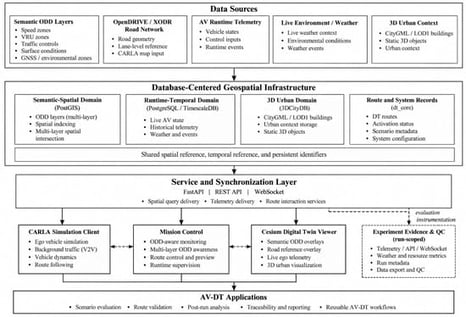
Proposed database-centered AV-DT architecture.
  • Article
  • Open Access

SBAS InSAR, UAV, and Numerical Modeling of Slope Instability in Tbilisi, Georgia

  • Lasha Sukhishvili,
  • Salome Gogoladze and
  • Linda Nakashidze
  • + 2 authors

The Vere River basin in Tbilisi, Georgia, experienced a major cascading landslide–flood disaster in June 2015, emphasizing the need to evaluate the present stability of slopes adjacent to the former source area. This study combines small-baseline InSAR (SBAS), RTK-UAV photogrammetry, COSI-Corr image correlation and LS-RAPID numerical modeling to investigate whether the slope remains active and how it responds to changing pore-pressure conditions. Analysis of 109 ascending Sentinel-1 acquisitions acquired between April 2022 and October 2025 revealed persistent positive line-of-sight deformation across the investigated slope. Independent UAV/COSI-Corr analysis identified horizontal displacements of approximately 0.05–0.09 m over 149 days, exceeding the empirical relative displacement detection threshold of 0.0235 m. The measured displacement direction broadly follows the downslope and structural orientation, although its angular offset suggests that the movement is influenced by a combination of topography, bedding, fractures, and heterogeneous slope materials rather than a single planar control. LS-RAPID simulations further showed a nonlinear response to increasing prescribed pore-pressure ratio. Together, the observations indicate that the slope has not fully stabilized after the 2015 event and continues to undergo slow deformation while remaining sensitive to hydrological conditions. This is particularly important for Tbilisi because renewed slope instability in the Vere valley could interact with the confined river corridor and urban infrastructure, increasing the potential for cascading impacts.

Geomatics

14 October 2026

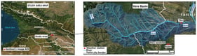
Study area. (A) Regional location of the study area within Georgia and the Sentinel-1 image area of interest (AOI); (B) Vere River basin showing the drainage network, Tbilisi city boundary, TSU and Kojori weather stations, and the location of the 2015 landslide. Basemap Sources: Esri, HERE, Garmin, OpenStreetMap contributors, Maxar, Earthstar Geographics, and the GIS User Community|Powered by Esri.
  • Article
  • Open Access

Coastal wetlands at urban margins experience interacting thermal, land-surface and hydrological pressures, yet composite remote-sensing assessments require transparent weighting, uncertainty analysis and careful interpretation. This study assessed late-autumn to early-winter environmental conditions across the 6.906 km2 Mai Po Marshes–Inner Deep Bay wetland system, Hong Kong, from 2000 to 2025. Landsat Collection 2 Tier 1 Level-2 scenes were harmonized into annual October–December composites to derive land-surface temperature, NDVI, MNDWI, NDBI, water-observation frequency and mapped aquatic area. The Relative Potential Hydrological Connectivity Index combined annual water frequency with proximity to persistent Inner Deep Bay open water, while the Wetland Environmental Stress Index integrated thermal stress, built-up pressure, vegetation deficit, moisture deficit and hydrological isolation using equal weights. Across 22 adequately observed years, NDVI increased significantly and MNDWI declined significantly. Mapped aquatic area also declined significantly, with a primary-threshold Theil–Sen slope of −0.04796 km2 per year. Full-series MNDWI sensitivity tests using thresholds of >0.00, >0.10 and >0.20 retained significant aquatic-area declines at all thresholds. In contrast, RPHCI showed no significant monotonic trend under any of the three MNDWI thresholds, and equal-weight WESI likewise showed no significant monotonic trend. Weighting sensitivity indicated stable annual rankings but substantial class changes under hydrology-emphasis weighting. The Landsat–MODIS temperature comparison showed poor agreement and was not treated as validation. Thus, WESI and RPHCI remain season-specific remote-sensing proxies rather than direct measures of annual ecological condition or hydraulic exchange within this wetland system.

Geomatics

10 October 2026

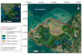
Location of the 6.906 km2 Mai Po Marshes–Inner Deep Bay study area and Inner Deep Bay source zone in north-western Hong Kong. Coordinate labels were checked against the uploaded study-area geometry, which spans approximately 113.999–114.034° E and 22.471–22.504° N. The scale bar at 1 km integer intervals.
  • Article
  • Open Access

Mobile Mapping Systems (MMSs) are increasingly adopted for transport infrastructure inspection, where reliable characterization of global and local geometry is essential. This is critical in GNSS-denied environments such as road tunnels, where trajectory estimation relies on inertial navigation and drift degrades geometric accuracy. This study investigates the influence of acquisition speed and ground control point (GCP) configuration on trajectory accuracy and geometric consistency in a 2.3 km road tunnel. MMS data were acquired at 15, 30, and 50 km/h and processed under progressively denser, uniformly distributed GCP configurations, from unconstrained to fully constrained solutions. Post-processed forward–backward smoothed GNSS/INS trajectories were validated against a topographic control network, and cross-sectional geometry against terrestrial laser scanning (TLS). Without external constraints, planimetric errors at independent check points reached 16.5 m and global deformation reached 0.46% at low speed. Ground control markedly reduced trajectory errors, depending on both control density and acquisition speed. In contrast, locally registered cross-sections showed millimeter-level consistency with TLS in all configurations: median discrepancies of 4–5 mm, with 75–82% of values below 10 mm. Local cross-sectional shape is therefore preserved despite substantial global drift, supporting MMS for shape-based tunnel inspection, while adequate ground control remains necessary for absolute georeferencing.

Geomatics

10 October 2026

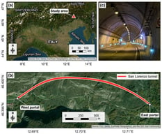
Study area overview. (a) Location of the investigated tunnel in Northern Italy (Forni di Sotto, Udine), indicated by the marker. (b) Detailed view of the tunnel alignment. (c) Representative view of the tunnel interior.

Featured Articles of Last Quarter

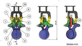
Assembly of closed grab arm.
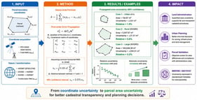
Urban parcel measured directly in HGRS87 (Drama, Greece). Boundary vertices were observed by network RTK and are expressed in the HGRS87 projected coordinate system (EPSG:2100). The parcel boundary is highlighted; the underlying plan is reproduced from Hellenic Cadastre records.
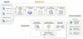
HyperCoreg workflow. The diagram summarizes the full processing chain used to co-register PRISMA and EnMAP hyperspectral scenes to Sentinel-2 Level-2A reference data. It begins with user configuration and sensor-specific preparation of the hyperspectral input, continues through automated Sentinel-2 candidate search and ranking, spectral band pairing, global and local AROSICS-based co-registration, tie-point filtering, quality-control decisions, geometric transformation, validation, and report/output generation. Green blocks indicate workflow functions added by HyperCoreg around the AROSICS core, including automated reference selection, detector-aware preparation, staged quality control, and operational output management. Notation: CDSE—Copernicus Data Space Ecosystem; CLI—Command-Line Interface; CRS—Coordinate Reference System; GUI—Graphical User Interface; GCP—Ground Control Point; QC—Quality Control; SCL—Scene Classification Layer; S2—Sentinel-2; TPS—Thin-Plate Spline.

Highly Accessed Articles

News & Conferences

Latest Issues

Open for Submission

Journal Sections

Advances in Hydrological Remote Sensing
Reprint

Advances in Hydrological Remote Sensing

Editors: Hailong Liu, Liangliang Jiang
Advances in Ocean Mapping and Nautical Cartography
Reprint

Advances in Ocean Mapping and Nautical Cartography

Editors: Giuseppe Masetti, Ian Church, Anand Hiroji, Ove Andersen
XFacebookLinkedIn
Geomatics - ISSN 2673-7418