

ISPRS Int. J. Geo-Inf., Volume 14, Issue 6 (June 2025) – 28 articles
Cover Story (view full-size image):
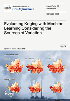
Integrating spatio-temporal kriging with machine learning enhances overall estimation accuracy by addressing complex spatial and temporal variations. However, the improvements are largely attributed to the effective modeling of global trends, which is not sufficient to justify the selection of kriging methods. This study evaluates the effectiveness of combining these approaches, focusing on their impact on overall accuracy and the contributions to global trends and spatio-temporal interactions. The results indicate the integration improves overall accuracy. Polynomial regression produces smoother patterns by capturing gradual variations in global trends, whereas random forest and boosting yield more abrupt patterns. This study highlights the importance of considering the sources of variation in phenomena when selecting kriging methods. View this paper
- Issues are regarded as officially published after their release is announced to the table of contents alert mailing list.
- You may sign up for e-mail alerts to receive table of contents of newly released issues.
- PDF is the official format for papers published in both, html and pdf forms. To view the papers in pdf format, click on the "PDF Full-text" link, and use the free Adobe Reader to open them.
Previous Issue
Next Issue