

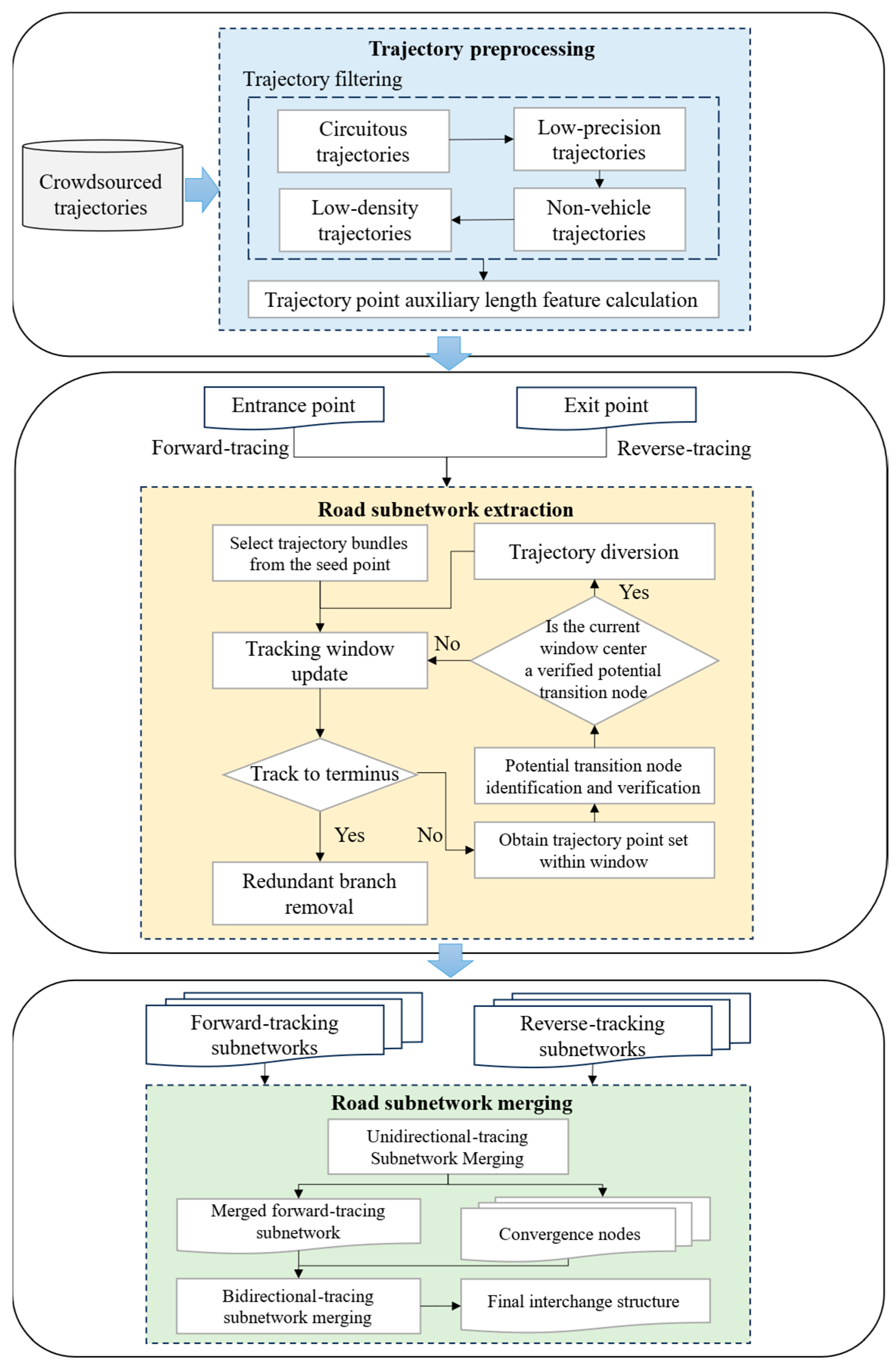
Automatic Extraction of Road Interchange Networks from Crowdsourced Trajectory Data: A Forward and Reverse Tracking Approach

Abstract
1. Introduction
- We develop a novel road network generation method particularly for road interchanges. This method adopts a divide-and-conquer strategy by decomposing road interchange networks into subnetworks for various types of road interchanges and addresses the challenge posed by the multi-level complex structure and crowdsourced data quality issues.
- A forward and reverse tracking mechanism that leverages long-term trajectory continuity is proposed to accurately identify transition nodes at road interchanges. This method avoids generating false intersections in areas where upper and lower-level roads interweave. Transition nodes are categorized into divergence nodes (via forward tracking) and convergence nodes (via reverse tracking).
- Extensive experiments were conducted using real-world trajectory data. The proposed method achieves an average improvement of 13.3% in score and 12.1% in score, outperforming two baseline methods. The method demonstrates robust performance across various types of road interchanges, including cloverleaf, turbo, and trumpet interchanges.
2. Methodology
2.1. Trajectory Preprocessing
- Circuitous trajectory filtering: Circuitous trajectories, characterized by frequent directional changes within localized spatial ranges, form compact morphologies distinguishable via geometric metrics, as illustrated in Figure 4a. The minimum enclosing rectangle (MER) of such trajectories provides two key indicators: the aspect ratio, which identifies narrow or clustered patterns (low values), and the area, reflecting their limited spatial extent. These traits correlate with a low morphology index (SI). Trajectories with SI below a predefined a threshold value are classified as circuitous trajectories and eliminated during preprocessing. The threshold value is defined as the mth-percentile of all trajectory morphology indices. SI is calculated as described below:where and represent the values normalized to the aspect ratio and area of the minimum enclosing rectangle for each trajectory, respectively, and is the influence weight. Since the aspect ratio and area of the minimum enclosing rectangle are equally important in determining whether the trajectory is distributed on the overpass, we set the value of to 0.5.
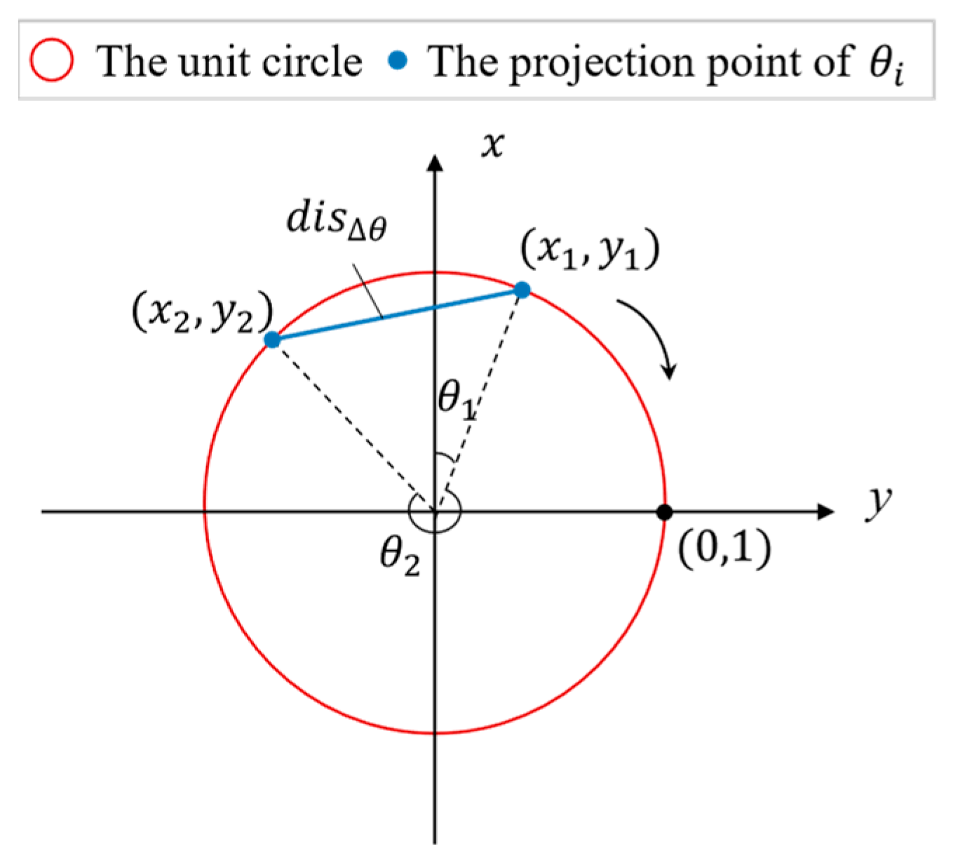
- Low-precision trajectory filtering: Low-precision trajectories are defined by a high proportion of points deviating significantly from the road surface, as shown in Figure 4b. To quantify this deviation, we compare two orientation metrics: (1) the original heading angle () of individual trajectory points, reflecting instantaneous vehicle direction, and (2) the direction angle () derived from adjacent points, representing the local road segment’s morphology. The angular distance between and serves as a deviation indicator—values exceeding a threshold suggest abnormal lateral drift. Since angular differences in raw angle space do not linearly correlate with geometric distance, we project angles onto a unit circle to compute accurately, as illustrated in Figure 5. The is calculated as follows:where represents the original heading angle of trajectory points, represents the direction angle calculated from adjacent trajectory points, are the coordinates of on the unit circle. Trajectories with a high proportion of trajectory points exhibiting low horizontal positioning accuracy, exceeding a specified ratio, are filtered out.
- Non-vehicle trajectory filtering: Non-vehicle trajectories (e.g., walking, cycling) are spatially confined to non-motorized lanes and exhibit distinct speed profiles compared to vehicular movement, as illustrated in Figure 4c. Multi-level interchanges prioritize vehicular flow through separated ramps and straight lanes, enabling higher sustained speeds. We leverage this design feature to differentiate vehicle trajectories from non-vehicle ones: trajectories with an overall average speed and maximum speed are classified as non-vehicle trajectories. These trajectories are filtered during preprocessing to retain only vehicular movement patterns.
- Low-density trajectory filtering: Low-density trajectories are defined by a sparse distribution of points deviating from dense vehicular trace bundles, as illustrated in Figure 4d. Road interchanges, designed for high traffic capacity, exhibit concentrated vehicle trajectory clusters due to sustained traffic flow. We quantify trajectory sparsity using neighboring flux , which measures local trajectory density over extended segments. Trajectories with persistently below an empirically defined threshold are identified as low-density outliers and filtered out during preprocessing. This ensures retention of statistically representative vehicular movement patterns while removing anomalous deviations.
2.2. Road Subnetwork Extraction
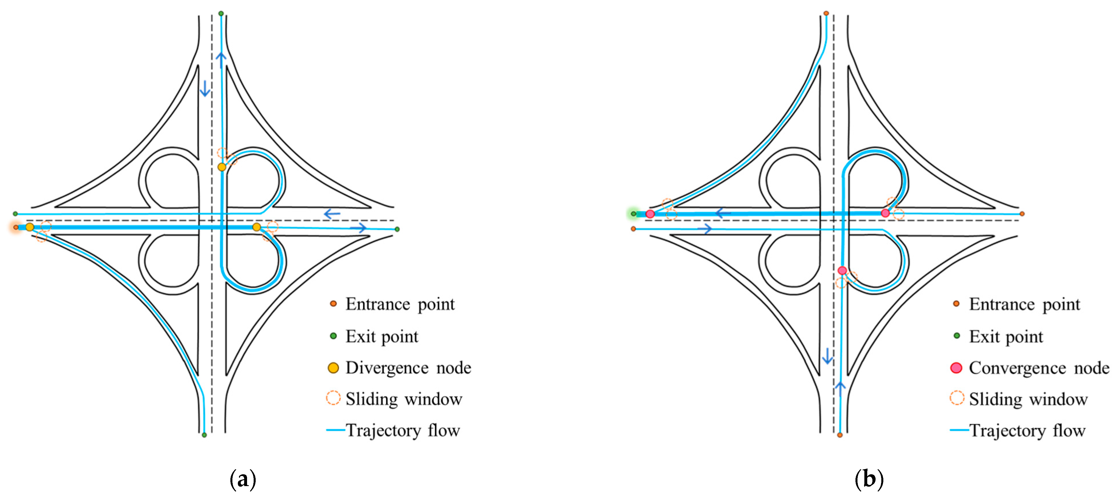
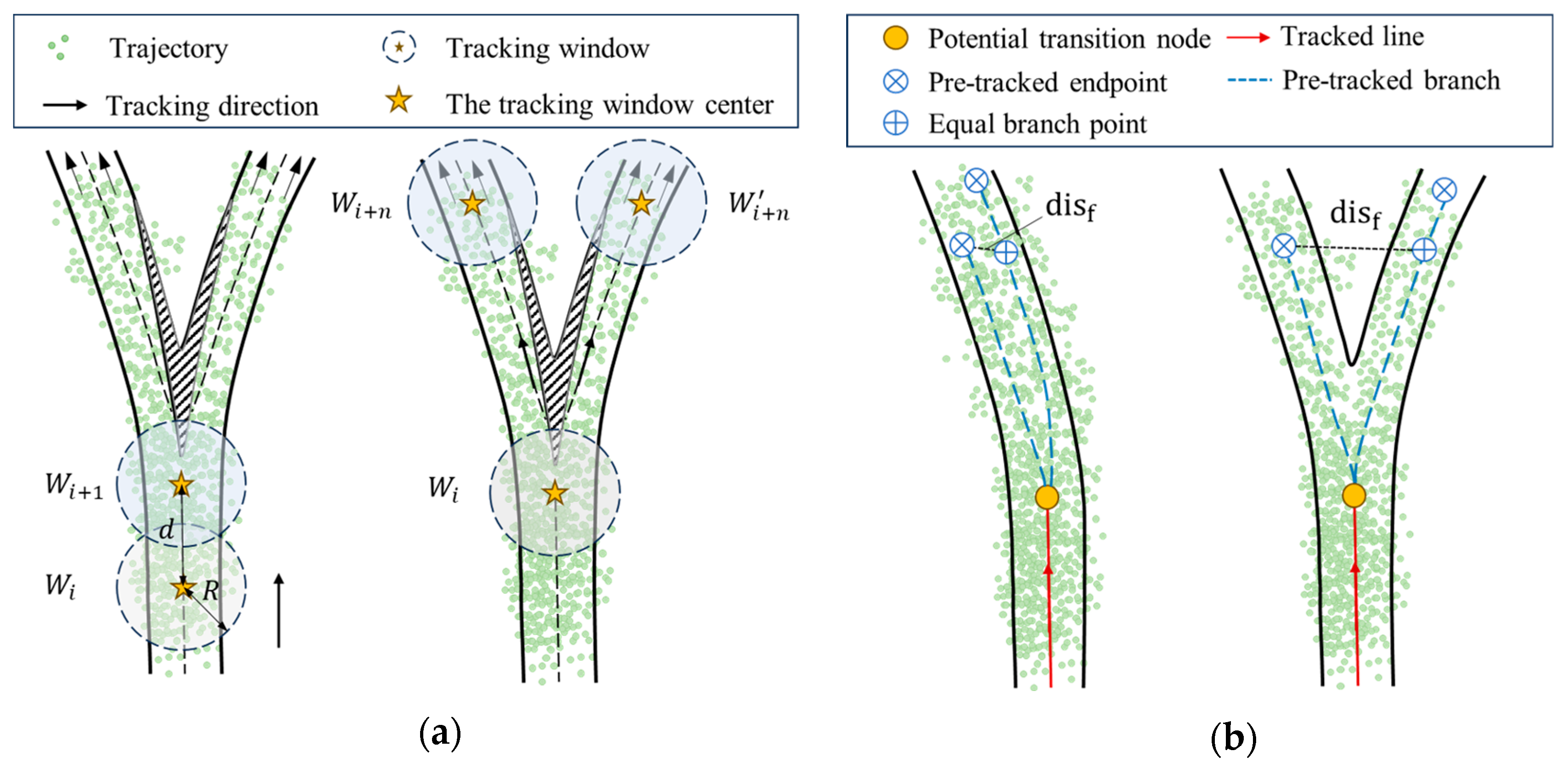
2.2.1. Transition Node Detection
2.2.2. Trajectory Diversion
2.2.3. Redundant Branch Removal
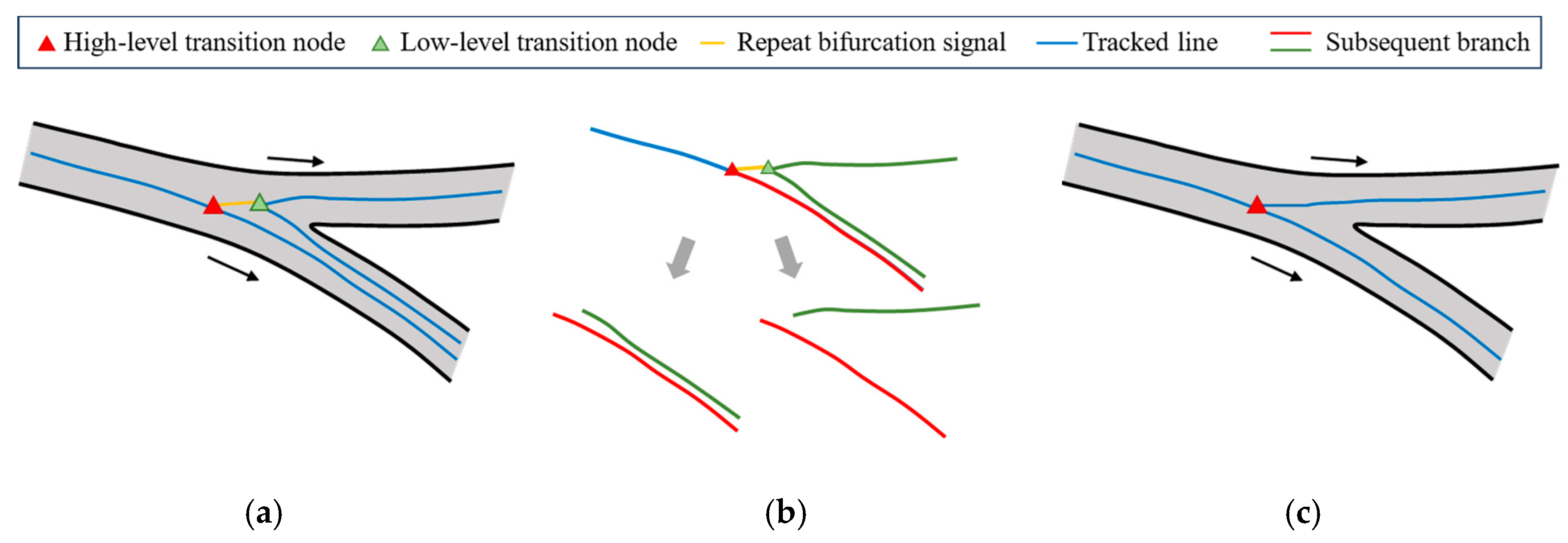
- Repeated bifurcation detection: At road interchanges, roads typically do not diverge frequently over short distances. Instead, redundant branches are often associated with repeated transition nodes, with short branches serving as indicators of repeated bifurcation signal, as illustrated in Figure 8a. These short branches are used to detect potential repeated transition nodes.
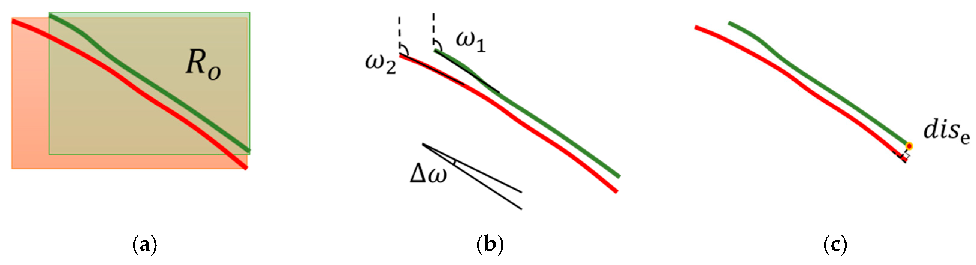
- Subsequent branch matching: The two transition nodes associated with a short branch are defined as a high-level transition node and a low-level transition node, based on their occurrence in the direction of branch extension. The matching of subsequent branches at these transition nodes is determined by the maximum overlap of the outer rectangle of the branch , the difference in branch direction , and the projection distance of the branch endpoint . The branch matching process is illustrated in Figure 8b, with the meaning of each index shown in Figure 9. When the conditions in Formula (3) are met, the two branches are considered successfully matched. Since the matched branches represent the same road section structure, redundant branches are eliminated.
- Redundant Branch Pruning: As shown in Figure 8c, when a branch is successfully matched and the end connected to the low-level transition node does not continue to bifurcate, the branch is directly deleted. If bifurcation continues, the local structure at the branch end is first integrated, and then redundant branches are eliminated. The integration of the local structure also involves sub-structure fusion, which will be discussed in detail in Section 2.3.
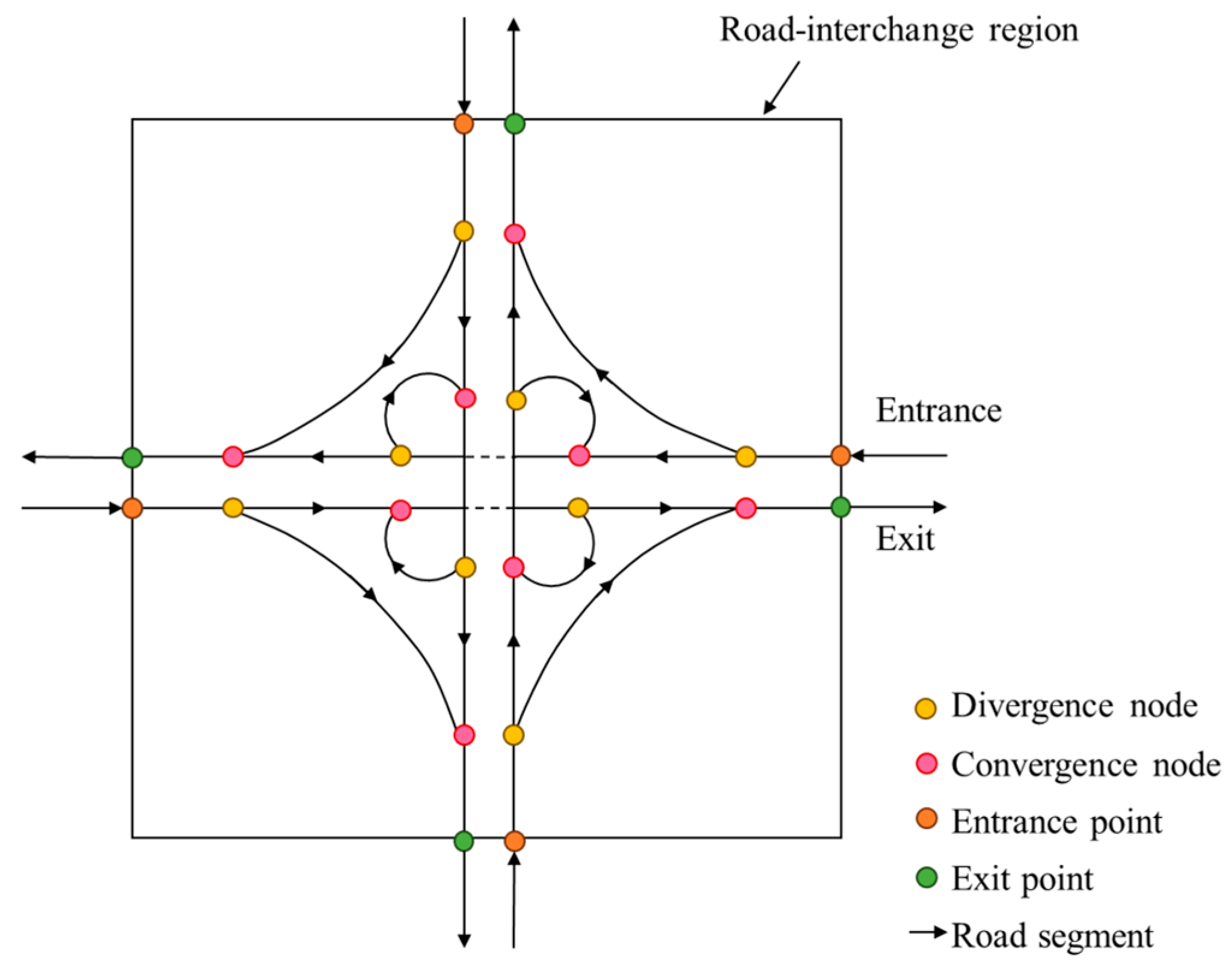
2.3. Road Subnetwork Merging
2.3.1. Unidirectional-Tracing Subnetwork Merging
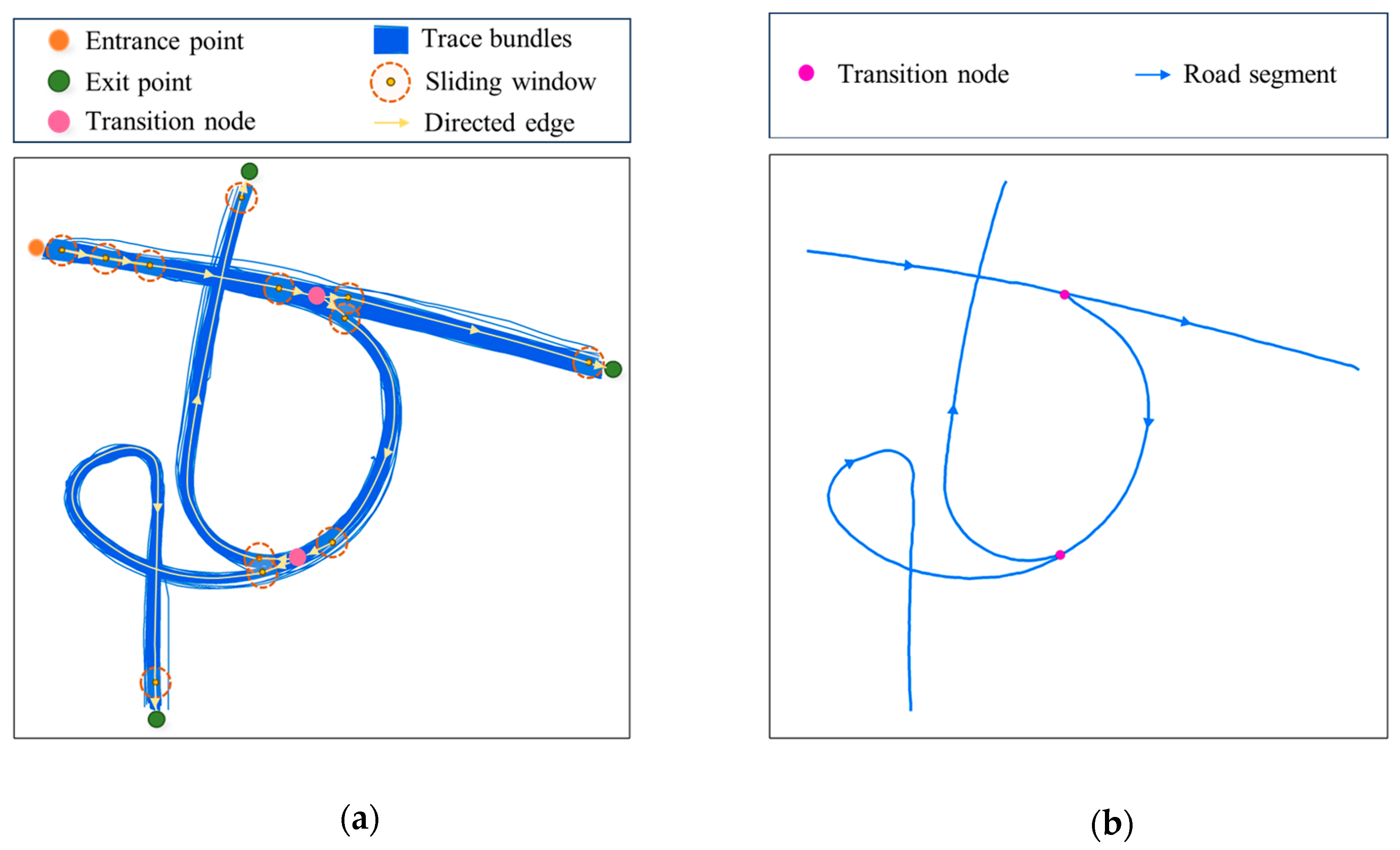
- Dynamically identify clusters of transition nodes within all sub-networks that are spatially close to each other using the DBSCAN method.
- For each cluster, select two transition nodes one at a time, and determine whether they represent the same road bifurcation by checking if the direction of the road at both nodes differs by no more than 20°. Once identified, match the subsequent branches of these two points (following the method outlined in Section 2.2.3). The center of these two nodes is then taken as the new transition node after merging. Matched branches are aligned, resampled, and fused. Connection relationships between the fused transition node and branches are updated to preserve topological consistency before and after fusion. This process is repeated until all transition nodes within the cluster that represent the same road bifurcation are merged.
- Following these steps, transition nodes, branches, and their clusters are updated iteratively. Structural fragment fusion terminates once each cluster retains a single transition node or clusters correspond to distinct road bifurcations.
2.3.2. Bidirectional-Tracing Subnetwork Merging
3. Experiments and Evaluation
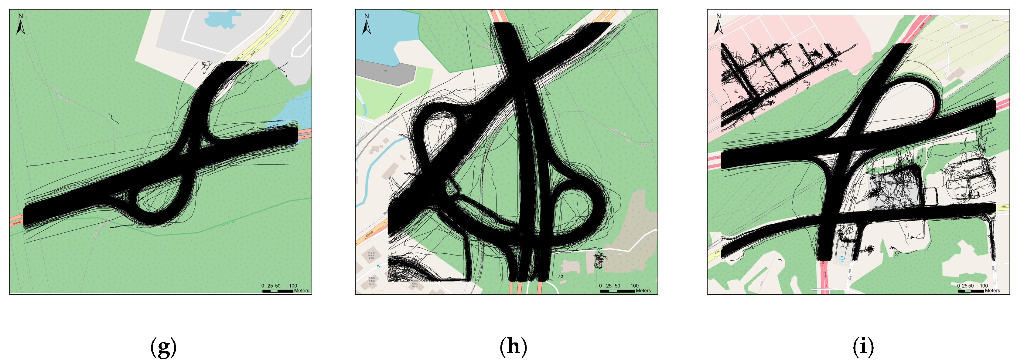
3.1. Experiment Data and Settings
3.2. Assessment Method
3.3. Experiment Results
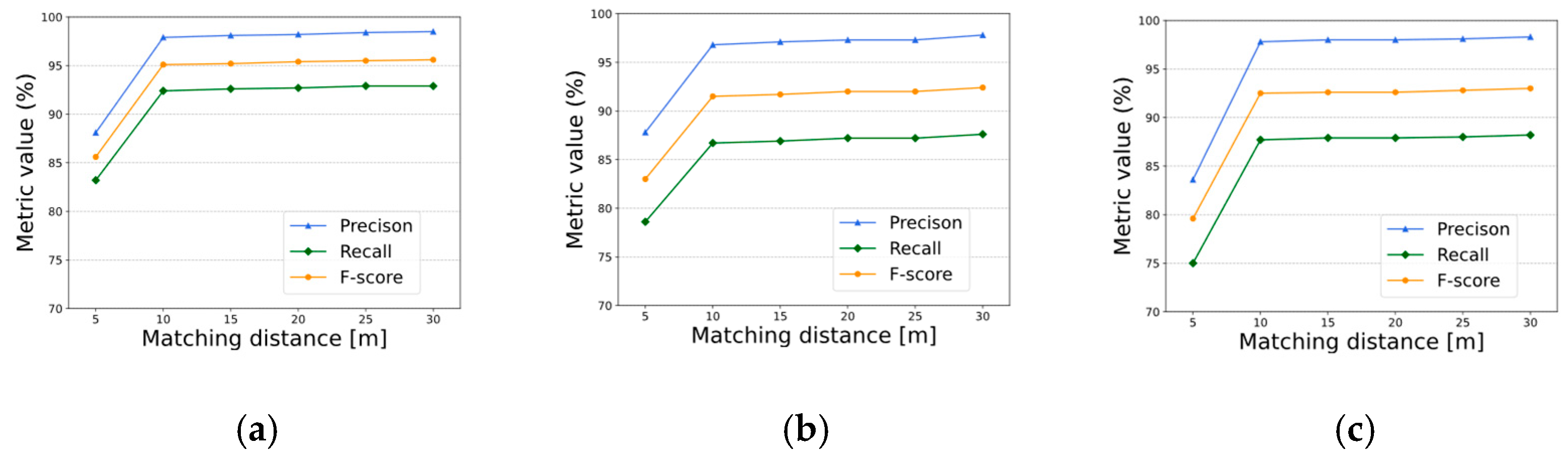
3.3.1. Parameter Settings
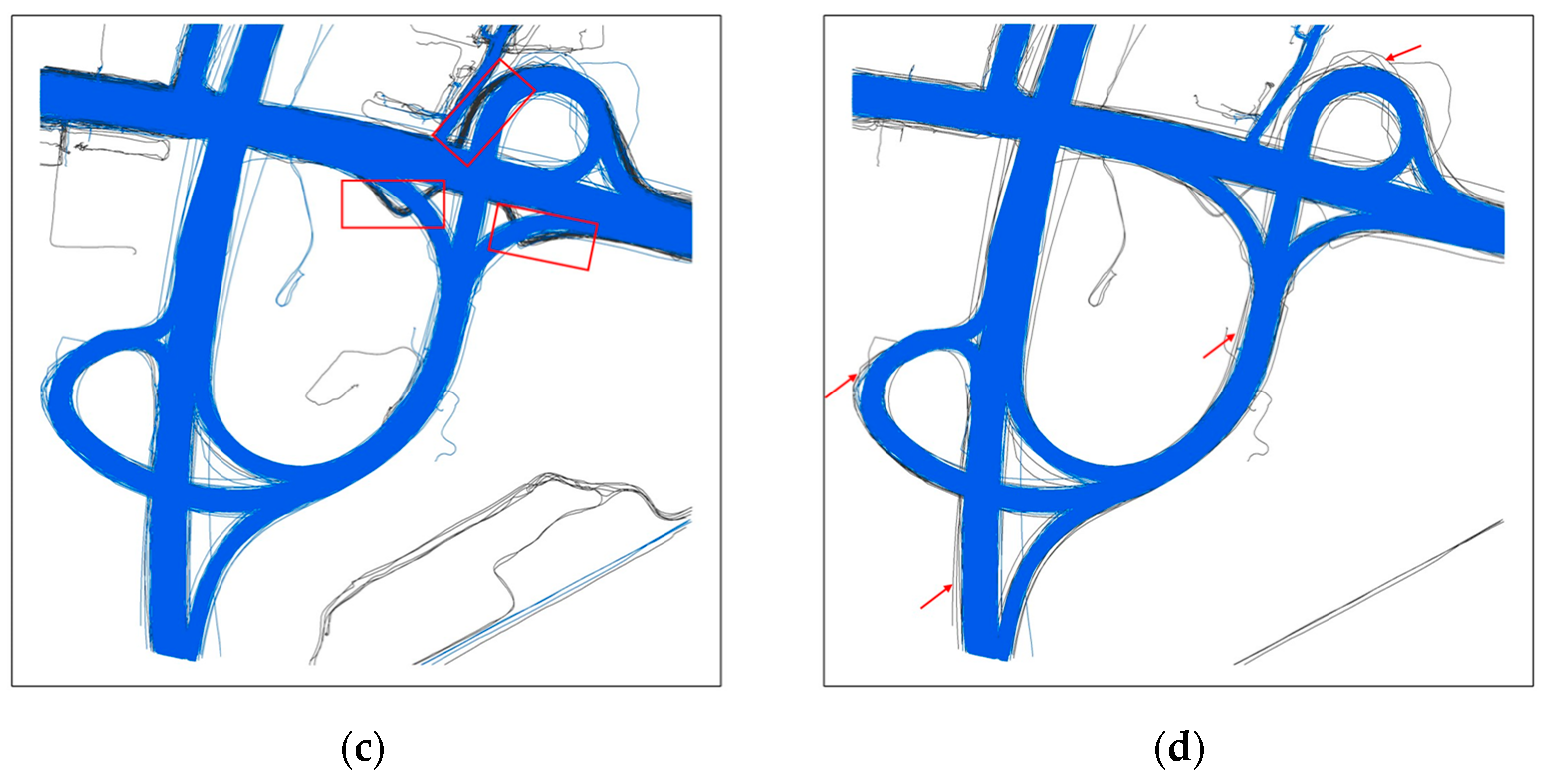
3.3.2. Results Analysis
3.3.3. Comparison with Other Methods
- Kharita [30]: This algorithm extracts the road network in two phases: node extraction through clustering and edge extraction by connecting nodes based on consecutive trajectory points.
- RoadRunner [19]: This algorithm develops a two-step approach that traces new road segments at path bifurcations, and then merges these segments by aligning the future trajectory flow.
3.3.4. Sensitivity Analysis
4. Conclusions
Author Contributions
Funding
Data Availability Statement
Acknowledgments
Conflicts of Interest
References
- Nugmanova, A.; Arndt, W.-H.; Hossain, M.A.; Kim, J.R. Effectiveness of Ring Roads in Reducing Traffic Congestion in Cities for Long Run: Big Almaty Ring Road Case Study. Sustainability 2019, 11, 4973. [Google Scholar] [CrossRef]
- Afrin, T.; Yodo, N. A Survey of Road Traffic Congestion Measures towards a Sustainable and Resilient Transportation System. Sustainability 2020, 12, 4660. [Google Scholar] [CrossRef]
- Gu, X.; Abdel-Aty, M.; Xiang, Q.; Cai, Q.; Yuan, J. Utilizing UAV Video Data for In-Depth Analysis of Drivers’ Crash Risk at Interchange Merging Areas. Accid. Anal. Prev. 2019, 123, 159–169. [Google Scholar] [CrossRef] [PubMed]
- Ding, Y.; Yao, Y.; Yang, L.; Zhao, X. Study on Safety Features of Road and Traffic Facilities at the Entrance of Interchange Area. In Proceedings of the 2019 5th International Conference on Transportation Information and Safety (ICTIS), Liverpool, UK, 14–17 July 2019; pp. 1469–1475. [Google Scholar]
- Jalayer, M.; Zhou, H.; Zhang, B. Evaluation of Navigation Performances of GPS Devices near Interchange Area Pertaining to Wrong-Way Driving. J. Traffic Transp. Eng. Engl. Ed. 2016, 3, 593–601. [Google Scholar] [CrossRef]
- Ekpenyong, F.; Palmer-Brown, D.; Brimicombe, A. Extracting Road Information from Recorded GPS Data Using Snap-Drift Neural Network. Neurocomputing 2009, 73, 24–36. [Google Scholar] [CrossRef]
- Hu, J.; Razdan, A.; Femiani, J.C.; Cui, M.; Wonka, P. Road Network Extraction and Intersection Detection From Aerial Images by Tracking Road Footprints. IEEE Trans. Geosci. Remote Sens. 2007, 45, 4144–4157. [Google Scholar] [CrossRef]
- Zhang, J.; Hu, X.; Wei, Y.; Zhang, L. Road Topology Extraction From Satellite Imagery by Joint Learning of Nodes and Their Connectivity. IEEE Trans. Geosci. Remote Sens. 2023, 61, 1–13. [Google Scholar] [CrossRef]
- Zhu, Q.; Zhang, Y.; Wang, L.; Zhong, Y.; Guan, Q.; Lu, X.; Zhang, L.; Li, D. A Global Context-Aware and Batch-Independent Network for Road Extraction from VHR Satellite Imagery. ISPRS J. Photogramm. Remote Sens. 2021, 175, 353–365. [Google Scholar] [CrossRef]
- Li, Y.; Xiang, L.; Zhang, C.; Jiao, F.; Wu, C. A Guided Deep Learning Approach for Joint Road Extraction and Intersection Detection from RS Images and Taxi Trajectories. IEEE J. Sel. Top. Appl. Earth Obs. Remote Sens. 2021, 14, 8008–8018. [Google Scholar] [CrossRef]
- Wang, J.; Wang, C.; Song, X.; Raghavan, V. Automatic Intersection and Traffic Rule Detection by Mining Motor-Vehicle GPS Trajectories. Comput. Environ. Urban Syst. 2017, 64, 19–29. [Google Scholar] [CrossRef]
- Gao, L.; Wei, L.; Yang, J.; Li, J. Automatic Intersection Extraction Method for Urban Road Networks Based on Trajectory Intersection Points. Appl. Sci. 2022, 12, 5873. [Google Scholar] [CrossRef]
- Du, J.; Liu, X.; Meng, C. Road Intersection Extraction Based on Low-Frequency Vehicle Trajectory Data. Sustainability 2023, 15, 14299. [Google Scholar] [CrossRef]
- Tang, J.; Deng, M.; Huang, J.; Liu, H. A Novel Method for Road Intersection Construction From Vehicle Trajectory Data. IEEE Access 2019, 7, 95065–95074. [Google Scholar] [CrossRef]
- Huang, J.; Deng, M.; Zhang, Y.; Liu, H. Complex road intersection modelling based on low-frequency GPS track data. Int. Arch. Photogramm. Remote Sens. Spat. Inf. Sci. 2017, XLII-2-W7, 23–28. [Google Scholar] [CrossRef]
- Deng, M.; Huang, J.; Zhang, Y.; Liu, H.; Tang, L.; Tang, J.; Yang, X. Generating Urban Road Intersection Models from Low-Frequency GPS Trajectory Data. Int. J. Geogr. Inf. Sci. 2018, 32, 2337–2361. [Google Scholar] [CrossRef]
- Stanojevic, R.; Abbar, S.; Thirumuruganathan, S.; Chawla, S.; Filali, F.; Aleimat, A. Robust Road Map Inference through Network Alignment of Trajectories. In Proceedings of the 2018 SIAM International Conference on Data Mining (SDM), San Diego, CA, USA, 3–5 May 2018; Proceedings. Society for Industrial and Applied Mathematics: Philadelphia, PA, USA, 2018; pp. 135–143. [Google Scholar]
- Cao, L.; Krumm, J. From GPS Traces to a Routable Road Map. In Proceedings of the 17th ACM SIGSPATIAL International Conference on Advances in Geographic Information Systems, Seattle, WA, USA, 4–6 November 2009; Association for Computing Machinery: New York, NY, USA, 2009; pp. 3–12. [Google Scholar]
- He, S.; Bastani, F.; Abbar, S.; Alizadeh, M.; Balakrishnan, H.; Chawla, S.; Madden, S. RoadRunner: Improving the Precision of Road Network Inference from GPS Trajectories. In Proceedings of the 26th ACM SIGSPATIAL International Conference on Advances in Geographic Information Systems, Seattle, WA, USA, 6–9 November 2018; Association for Computing Machinery: New York, NY, USA, 2018; pp. 3–12. [Google Scholar]
- Wang, J.; Rui, X.; Song, X.; Tan, X.; Wang, C.; Raghavan, V. A Novel Approach for Generating Routable Road Maps from Vehicle GPS Traces. Int. J. Geogr. Inf. Sci. 2015, 29, 69–91. [Google Scholar] [CrossRef]
- Sun, T.; Di, Z.; Che, P.; Liu, C.; Wang, Y. Leveraging Crowdsourced GPS Data for Road Extraction From Aerial Imagery. In Proceedings of the 2019 IEEE/CVF Conference on Computer Vision and Pattern Recognition (CVPR), Long Beach, CA, USA, 15–20 June 2019; pp. 7501–7510. [Google Scholar]
- Qin, J.; Yang, W.; Wu, T.; He, B.; Xiang, L. Incremental Road Network Update Method with Trajectory Data and UAV Remote Sensing Imagery. ISPRS Int. J. Geo-Inf. 2022, 11, 502. [Google Scholar] [CrossRef]
- Cheng, L.; Wu, Y.; Wang, Y.; Zhong, L.; Chen, Y.; Li, M. Three-Dimensional Reconstruction of Large Multilayer Interchange Bridge Using Airborne LiDAR Data. IEEE J. Sel. Top. Appl. Earth Obs. Remote Sens. 2015, 8, 691–708. [Google Scholar] [CrossRef]
- Zhou, Y.; Huang, R.; Jiang, T.; Dong, Z.; Yang, B. Highway Alignments Extraction and 3D Modeling from Airborne Laser Scanning Point Clouds. Int. J. Appl. Earth Obs. Geoinf. 2021, 102, 102429. [Google Scholar] [CrossRef]
- Li, X.; Liu, C.; Wang, Z.; Xie, X.; Li, D.; Xu, L. Airborne LiDAR: State-of-the-Art of System Design, Technology and Application. Meas. Sci. Technol. 2020, 32, 032002. [Google Scholar] [CrossRef]
- Ren, C.; Tang, L.; Yang, X.; Long, J. Mapping Grade-Separated Junctions in Detail Using Crowdsourced Trajectory Data. IEEE Trans. Intell. Transp. Syst. 2022, 23, 5552–5561. [Google Scholar] [CrossRef]
- Yang, X.; Yang, M.; Cao, Y.; Ren, C.; Zhang, F.; Tang, L. Three-Dimensional Structure Determination of Grade-Separated Road Intersections from Crowdsourced Trajectories. Int. J. Appl. Earth Obs. Geoinf. 2023, 125, 103598. [Google Scholar] [CrossRef]
- Phuengsaeng, P.; Sutthisangiam, N. Automatic Corrective Elevation of GPS Trajectory in Urban Area. In Proceedings of the 2018 18th International Symposium on Communications and Information Technologies (ISCIT), Bangkok, Thailand, 26–29 September 2018; pp. 458–462. [Google Scholar]
- Basiri, A.; Haklay, M.; Foody, G.; Mooney, P. Crowdsourced Geospatial Data Quality: Challenges and Future Directions. Int. J. Geogr. Inf. Sci. 2019, 33, 1588–1593. [Google Scholar] [CrossRef]
- Zhang, X.; Yang, Z.; Wu, C.; Sun, W.; Liu, Y.; Xing, K. Robust Trajectory Estimation for Crowdsourcing-Based Mobile Applications. IEEE Trans. Parallel Distrib. Syst. 2014, 25, 1876–1885. [Google Scholar] [CrossRef]
- Li, D.; Li, J.; Li, J. Road Network Extraction from Low-Frequency Trajectories Based on a Road Structure-Aware Filter. ISPRS Int. J. Geo-Inf. 2019, 8, 374. [Google Scholar] [CrossRef]
- Scott, D.W. Multivariate Density Estimation and Visualization. In Handbook of Computational Statistics: Concepts and Methods; Gentle, J.E., Härdle, W.K., Mori, Y., Eds.; Springer: Berlin/Heidelberg, Germany, 2012; pp. 549–569. ISBN 978-3-642-21551-3. [Google Scholar]
- Bashtannyk, D.M.; Hyndman, R.J. Bandwidth Selection for Kernel Conditional Density Estimation. Comput. Stat. Data Anal. 2001, 36, 279–298. [Google Scholar] [CrossRef]
- Yan, X.; Pei, T.; Shu, H.; Song, C.; Wu, M.; Fang, Z.; Chen, J. Spatiotemporal Flow L-Function: A New Method for Identifying Spatiotemporal Clusters in Geographical Flow Data. Int. J. Geogr. Inf. Sci. 2023, 37, 1615–1639. [Google Scholar] [CrossRef]
- Pei, T.; Yan, X.; Shu, H.; Wang, X.; Chen, X.; Guo, S.; Jiang, J.; Song, C.; Chen, J. Geographical Flows: A Fresh Perspective on Quantifying Urban Function. Urban Inform. 2024, 3, 14. [Google Scholar] [CrossRef]
- Arthur, D.; Vassilvitskii, S. K-Means++: The Advantages of Careful Seeding. In Proceedings of the Eighteenth Annual ACM-SIAM Symposium on Discrete Algorithms, New Orleans, LA, USA, 7–9 January 2007; Society for Industrial and Applied Mathematics: Philadelphia, PA, USA, 2007; pp. 1027–1035. [Google Scholar]
- Biagioni, J.; Eriksson, J. Inferring Road Maps from Global Positioning System Traces: Survey and Comparative Evaluation. Transp. Res. Rec. 2012, 2291, 61–71. [Google Scholar] [CrossRef]
- CD 122—Geometric Design of Grade Separated Junctions. Available online: https://www.standardsforhighways.co.uk/search/3ab9ef31-9880-4e8e-a7eb-f3d218e74ffd (accessed on 14 March 2025).


| Method Category | Key Characteristics | Strengths | Weaknesses |
|---|---|---|---|
| Clustering | Groups GPS points into clusters via k-means, then connects cluster centroids | Fast and robust to trajectory data sparsity | Challenging to infer non-planar features; sensitive to the number of initial seeds and their locations |
| Entry/exit points-based | Detects entry/exit points at intersections, reconstructs roads via movement patterns | Effective for modeling turning relationships and detecting detailed geometry structure | Miss topology connection |
| Trace-merging | Starts from seed nodes and grows iteratively using trajectory continuity | Handles complex topologies (e.g., multi-level roads) | Spurious branching because of intertwined trajectories |
| Intersection-linking | Detects intersections first, then links them | Effective for intersection detection (including U-turns) and road connectivity preservation | Hard to distinguish between adjacent lanes |
| Name of the Road Interchange | Precision | Recall | Score | Score |
|---|---|---|---|---|
| Dafapu | 0.9786 | 0.8779 | 0.9255 | 0.9242 |
| Chuangye | 0.9686 | 0.8675 | 0.9153 | 0.9202 |
| Binhai | 0.9225 | 0.7545 | 0.8301 | 0.8482 |
| Baoan | 0.9600 | 0.8098 | 0.8785 | 0.8774 |
| Beihuan | 0.9796 | 0.9246 | 0.9513 | 0.9608 |
| Shahexi | 0.8934 | 0.8778 | 0.8855 | 0.8786 |
| Yulong | 0.9509 | 0.8479 | 0.8964 | 0.8619 |
| Liuxian | 0.9565 | 0.8826 | 0.9181 | 0.9360 |
| Shuiyan | 0.9633 | 0.8856 | 0.9228 | 0.8986 |
| Method | Beihuan | Chuangye | Dafapu | |||||||||
|---|---|---|---|---|---|---|---|---|---|---|---|---|
| Prec. | Rec. | Prec. | Rec. | Prec. | Rec. | |||||||
| Kharita | 0.097 | 0.830 | 0.174 | 0.185 | 0.077 | 0.778 | 0.140 | 0.140 | 0.124 | 0.894 | 0.219 | 0.213 |
| Road Runner | 0.607 | 0.929 | 0.734 | 0.761 | 0.686 | 0.827 | 0.750 | 0.761 | 0.896 | 0.922 | 0.908 | 0.918 |
| Our method | 0.979 | 0.924 | 0.951 | 0.960 | 0.968 | 0.867 | 0.915 | 0.920 | 0.978 | 0.877 | 0.925 | 0.924 |
Disclaimer/Publisher’s Note: The statements, opinions and data contained in all publications are solely those of the individual author(s) and contributor(s) and not of MDPI and/or the editor(s). MDPI and/or the editor(s) disclaim responsibility for any injury to people or property resulting from any ideas, methods, instructions or products referred to in the content. |
© 2025 by the authors. Published by MDPI on behalf of the International Society for Photogrammetry and Remote Sensing. Licensee MDPI, Basel, Switzerland. This article is an open access article distributed under the terms and conditions of the Creative Commons Attribution (CC BY) license (https://creativecommons.org/licenses/by/4.0/).
Share and Cite
Jiao, F.; Xiang, L.; Deng, Y. Automatic Extraction of Road Interchange Networks from Crowdsourced Trajectory Data: A Forward and Reverse Tracking Approach. ISPRS Int. J. Geo-Inf. 2025, 14, 234. https://doi.org/10.3390/ijgi14060234
Jiao F, Xiang L, Deng Y. Automatic Extraction of Road Interchange Networks from Crowdsourced Trajectory Data: A Forward and Reverse Tracking Approach. ISPRS International Journal of Geo-Information. 2025; 14(6):234. https://doi.org/10.3390/ijgi14060234
Chicago/Turabian StyleJiao, Fengwei, Longgang Xiang, and Yuanyuan Deng. 2025. "Automatic Extraction of Road Interchange Networks from Crowdsourced Trajectory Data: A Forward and Reverse Tracking Approach" ISPRS International Journal of Geo-Information 14, no. 6: 234. https://doi.org/10.3390/ijgi14060234
APA StyleJiao, F., Xiang, L., & Deng, Y. (2025). Automatic Extraction of Road Interchange Networks from Crowdsourced Trajectory Data: A Forward and Reverse Tracking Approach. ISPRS International Journal of Geo-Information, 14(6), 234. https://doi.org/10.3390/ijgi14060234