Abstract
Digital tools, especially games, are increasingly important for enabling citizen participation in urban planning. Among these, Minecraft has been widely utilized to engage children, leveraging its virtual environment to represent geospatial data. However, systematic methods for collecting and analyzing player-generated data within Minecraft remain underexplored. Playful Participatory Planning System (P-PPS) framework that transforms player actions (e.g., building, removing, planting) within Minecraft, using OpenStreetMap (OSM) data to create game environments, back into geospatial data for analysis. The framework’s applicability was demonstrated through two case studies, one with 58 schoolchildren and 18 adults in Ireland. The results reveal that schoolchildren, while highly engaged, demonstrated a high density of actions within limited areas, suggesting a need for guidance on spatial distribution and ecological considerations. In contrast, adults prioritized the urban context and exhibited greater spatial consistency in their actions. Challenges emerged in managing online interactions, emphasizing the need for clear guidelines and moderation strategies. This research demonstrates the potential of Minecraft as a platform for participatory urban planning, exploring its use as a collaborative immersive mapping tool.
1. Introduction
Digital technologies and their applications, including participatory mapping initiatives and immersive visualization and simulation environment, are key drivers in the ongoing transformation of urban understanding and development, increasingly fostering citizen engagement in urban planning [1,2], public resource allocation [3,4], and climate change adaptation [5]. McKinley et al. [5] argue that digital community engagement, despite challenges, significantly benefits certain demographics. It could facilitate more engagement from underrepresented groups such as younger members of the community, who are often difficult to engage through traditional methods [6]. Within the field of planning theory, the emerging Planning 3.0 paradigm [7] acknowledges the methodological shifts resulting from evolving digital participatory practices in spatial planning. Arnstein’s [8] often-cited eight-step ladder of citizen participation has been repeatedly adapted to reflect ICT advancements in different participation levels [9,10]. Despite new paradigms and models, public participation in planning phases remains unclear. Campagna et al. [11] emphasize the need for a framework to enhance understanding and effectiveness of citizen engagement.
In this context, the discussion on how to meaningfully include children and young people in planning processes remains open, especially on the institutional demand for their participation [12]. Integrating young people in public participation and decision-making has emerged as a focal point in policy since the Convention on the Rights of the Child [13], especially regarding its Article 12. Within Ireland’s progressive approach to youth engagement, the Framework for Children and Young People Participation in Decision-making [14] introduces the Lundy model [15] as guidance to decision-makers to consider these demographics in the process. This model identifies four key elements for achieving Article 12 of the UN: Space, Voice, Audience, and Influence. The framework recommends the model in order to achieve a proper influence on decision-making processes, including spatial planning. However, public bodies such as departments, agencies, and organizations, often face challenges in finding the proper channels to achieve this participation.
Reflecting the methodological shifts in Planning 3.0, the growing adoption of digital games offers a tangible way to enact these evolving digital participatory practices in community engagement, particularly with young people [16]. Serious games have been demonstrated to be exceedingly effective tools to engage children in the process of thinking about their cities and neighborhoods [17,18]. Among these tools, virtual worlds like Minecraft have emerged as promising platforms for civic engagement in urban planning and participatory processes [19]. Minecraft’s accessibility and intuitive interface make it particularly well-suited for engaging a broad audience in the planning process. Its spatial mechanics enhance the experience by combining exploration and building, where players have the agency to transform the world around them.
While previous research has explored the use of Minecraft for urban planning, primarily focusing on transforming geospatial data into Minecraft environments [20,21,22,23,24,25,26], the reverse process—transforming player actions within Minecraft back into geospatial data for analysis—has received less attention [27,28]. Studies examining player behavior within Minecraft have been conducted [29,30,31], but these have often lacked a strong focus on analyzing spatial decision-making within the context of specific real-world locations. Using Minecraft’s virtual environment presents an opportunity to investigate its use in data-driven informed spatial decision-making.
This research addresses these gaps by proposing a game-based framework, called “Playful Participatory Planning System” (P-PPS), that leverages the opportunities offered by Minecraft and offers the ability to easily extract and analyze spatial data from player-generated designs to inform planning decisions. The study demonstrates the development and testing of this system that leverages Minecraft’s popularity and scalability to engage young citizens in participatory planning processes by capitalizing on the game’s inherent spatial mechanics. The system involves using OpenStreetMap (OSM) data to create virtual replicas of real-world locations within Minecraft. By analyzing player interactions within these virtual environments, including their actions, movements, and in-game communication, we aim to extract valuable spatial data that can inform real-world urban planning decisions.
To investigate the P-PPS’s applicability, we conducted two pilot studies. The first study focused on testing the system’s implementation by engaging schoolchildren in a climate action-themed activity within a Minecraft environment. The second study involved co-design workshops with stakeholders, including teachers and local authorities, to assess the platform’s usability and gather feedback on the relevance of spatial gameplay analyses for their work. These stakeholders were presented with the platform and consulted on the relevance of the spatial gameplay analyses derived from player actions within Minecraft.
2. Context for This Study
This research emerges from the Craft-My-Street (CMS) project, an initiative funded by the Research Ireland OurTech Challenge. CMS aimed to investigate the potential of both analog and digital games as tools for participatory planning and education within the Irish context. The project specifically focused on environmental and climate change concepts, aligning with the national framework for children and young people’s participation in decision-making [14]. The findings presented herein are derived from a series of in-class activities and stakeholder workshops conducted during the Seed Phase of CMS, which involved the testing and prototyping of proposed project deliverables in different stages of development.
In Ireland, as highlighted by global concerns [13], children and young people currently possess limited avenues for meaningful participation in local decision-making processes concerning critical issues such as climate change and sustainability [32]. This lack of engagement is further compounded by a scarcity of readily available resources to equip teachers with the means to effectively introduce these complex topics to young learners and cultivate the skills necessary for them to actively engage in climate action [33].
The CMS project directly addresses these identified needs by developing a comprehensive framework of resources and knowledge intended for key stakeholders, namely local authority officers and educators. Drawing from the Lundy model’s principles, this framework is designed to be integrated into their consultation and teaching practices, thereby fostering greater youth engagement. The development of this framework was informed by a series of co-design workshops with stakeholders and iterative in-class activities, ensuring that the final outputs are relevant and responsive to the needs of both practitioners and young people.
3. Background and Related Work
3.1. Minecraft and Its Core Systems
Minecraft is a sandbox video game that allows players to interact with a generated, block-based world. The game’s environment consists of cubic one-meter blocks, each representing different materials such as soil, stone, and water, which players can place, remove (mine), or modify. The spatial structure of Minecraft follows a three-dimensional coordinate system (x, y, z), where y represents elevation. This system enables precise spatial referencing, making it suitable for geospatial analysis. Players interact with the game world through movement, construction, resource management, and crafting. The crafting system allows players to combine materials to create tools, building components, and other objects, influencing how they modify and shape the environment. These mechanics can partially simulate real-world spatial planning processes by enabling users to collaboratively design in multiplayer virtual environments, test spatial arrangements, and visualize urban development scenarios. These player-generated modifications can then be extracted as spatial data and analyzed to inform planning decisions.
3.2. Educational and Engagement Benefits of Games
The intersection of video games and education is a well-explored field, with numerous studies demonstrating the potential of serious games to enhance learning outcomes [31,34,35,36]. Minecraft, in particular, has been widely recognized for its educational value. Researchers have highlighted its capacity to foster creativity, problem-solving skills, and student collaboration. Sena and Stachon [37] highlight the inherent geogaming mechanics within Minecraft, emphasizing its potential for supporting learning activities in geography and cartography. The game incorporates a coordinate system, accessible by players through the F3 key, which provides spatial awareness within the virtual environment. This coordinate system, coupled with in-game tools like “empty maps” and the “cartography table”, empowers players to navigate and map their surroundings, fostering spatial reasoning and map-making skills.
The game offers an opportunity as a platform for enabling young people to express and articulate themselves using design skills they have been passively developing through normal play. The game also supports the development of 21st-century skills in school-age children, being an effective pedagogical tool when used in serious contexts [38]. The game’s flexibility allows educators to tailor experiences to specific learning objectives, making it a powerful educational resource.
Minecraft has also been used for participatory urban planning, geodesign and community engagement in many different contexts [22,23,25,26]. The Block by Block initiative, a collaboration between UN-Habitat and Mojang, utilizes Minecraft to involve communities in the design of public spaces [39]. The project has been implemented in various locations worldwide, allowing residents to contribute their ideas and preferences for urban development projects. The success of Block by Block underscores the potential of Minecraft as a tool for civic engagement and participatory planning.
3.3. Prior Studies in Gameplay Analytics and Minecraft
Several studies have highlighted the importance of analyzing player behavior in educational games [40,41]. For instance, Emerson et al. discussed using multimodal learning analytics to understand student interactions and learning outcomes in game-based learning environments [42]. The study demonstrated how combining data streams from gameplay analytics could predict student post-assessment performance and interest, thereby informing the design of more effective educational games and supporting personalized learning. Similarly, Shute and Ventura explored the potential of educational data mining to enhance learning experiences by identifying factors influencing student engagement and performance [43].
More recently, Yang et al. conducted an exploratory analysis of gameplay data from a serious game focused on climate change adaptation [44]. The researchers concluded that gameplay data could offer insights into players’ decision-making processes, including how they weighed different adaptation options and responded to uncertain climate impacts. Neset et al. assessed the potential and challenges of a serious digital game for urban climate adaptation [45]. The game aimed to provide players with an immersive experience of the impacts of climate adaptation measures and illustrate links to the UN’s Sustainable Development Goals. The researchers analyzed the game’s narrative, gameplay, content, and didactic elements, finding that serious games can be effective tools for climate education and engagement but also face challenges around balancing realism, playability, and learning objectives.
These studies demonstrate how gameplay analytics can be leveraged to better understand human behavior and decision-making in the context of spatial-related issues, such as planning and urban design. By analyzing how players interact with and respond to simulated climate scenarios, researchers can gain insights that could inform environmental education programs and policy development [46]. Analyzing player behavior in video games has become an increasingly important area of research, providing insights into player engagement, preferences, and decision-making processes [47,48]. More recently, Mahajan et al. (2024) introduced MineObserver 2.0, a novel framework that leverages deep learning to analyze the relationship between natural language descriptions and Minecraft imagery [49]. This research builds upon existing work in natural language processing and computer vision, aiming to enhance the understanding and interpretation of virtual environments. By integrating in-game analysis with advanced machine learning techniques, MineObserver 2.0 offers a promising approach to bridge the gap between human language and machine perception. In parallel, Zhou and Paquette (2024) investigated student interest within a Minecraft game-based learning environment using changepoint detection analysis [50]. Their study focused on the factors influencing student engagement and highlights the importance of understanding learner behavior to optimize game-based learning experiences.
4. Methodology
This study employed a three-stage methodology to investigate the use of Minecraft for participatory urban planning (Figure 1). Firstly, real-world geospatial data, sourced from OpenStreetMap (OSM), is transformed into interactive Minecraft environments through a custom plugin. This involves translating real-world coordinates into Minecraft’s block-based system, allowing for simplified representation of urban features within the game. Secondly, the participants engage in in-game activities within the Minecraft environment, generating spatial data through their interactions. These activities may include building, modifying, and exploring the virtual world. Thirdly, player actions within the Minecraft environment are meticulously captured and logged, including block placement, removal, movement, and interactions with other players. These data are then processed and analyzed to extract meaningful insights into player behavior and preferences. The methodology is structured to reflect the four key elements for children’s participation in decision-making, drawing upon the Lundy Model [15] and Ireland’s framework for participation [14].

Figure 1.
Schematic diagram of the P-PPS framework in line with the Lundy Model elements.
The collected data are transformed back into its original geospatial context, allowing for the visualization and analysis of player-generated content within OpenStreetMap. This enables the identification of spatial patterns, trends, and areas of interest. Two pilot studies were conducted to evaluate the P-PPS framework and assess its applicability in different contexts. The first study involved schoolchildren and focused on testing the framework’s effectiveness in generating geospatial data while engaging participants in educational activities within the Minecraft environment. The second study focused on co-designing the framework with stakeholders, including teachers and local authority officers, to ensure its usability and relevance in different applications, such as engagement and consultation with children.
4.1. Geospatial to Minecraft
Before any data can be obtained, generating a digital twin of a real-world region within Minecraft is the first step. Since the goal was to create models of large areas in Ireland, such as Dublin Docklands and Carlow, it would be complicated and inefficient to create such a map manually. Therefore, we developed a custom server modification that processes publicly available datasets and automatically generates digital visualization. For the datasets, we selected MERIT DEM [51] for an elevation model and OpenStreetMap for buildings, streets, land, and water features. The goal of the representation was not to be realistic, but rather informative. We achieved that by coloring the buildings according to their use, such as housing (bricks), industrial and commercial (white concrete), or religious (light gray concrete). OSM identifiers (keys and values) were used as a classification system to determine which Minecraft material (block type) to be used in the generated model, as shown in Table 1.

Table 1.
OSM Identifiers used for determining Minecraft material used to generate buildings and features in-game.
Representing a globe inside a flat world with 1:1 accuracy is impossible. Since the visualization will only contain a small area of the globe, a projection can approximately preserve distance, area, and local shape. A simple planar projection defined in Equation (1) makes a good fit in this case through a custom parametric (center latitude and longitude, scale factor) planar projection from WGS84 into flat x, z Minecraft coordinate system [52]. During the projection step, we modified the scale of the generated representation to make the area faster to traverse inside the game, utilizing an 80% scale model of the reality, while exaggerating buildings heights in 10% to approximate the visualization scale in the game with reality. The selected projection is also important for transforming the collected data back into real-world coordinates, as explained in Section 4.3.3.
The above is the formula for orthographic planar projection from longitude and latitude (λ, φ) to flat coordinates (x, y), where R is the radius of Earth, (λ0, φ0) is the center longitude and latitude of the projection (the tangent point), and s is the scaling factor of the projection.
4.2. Data Acquisition for Analysis
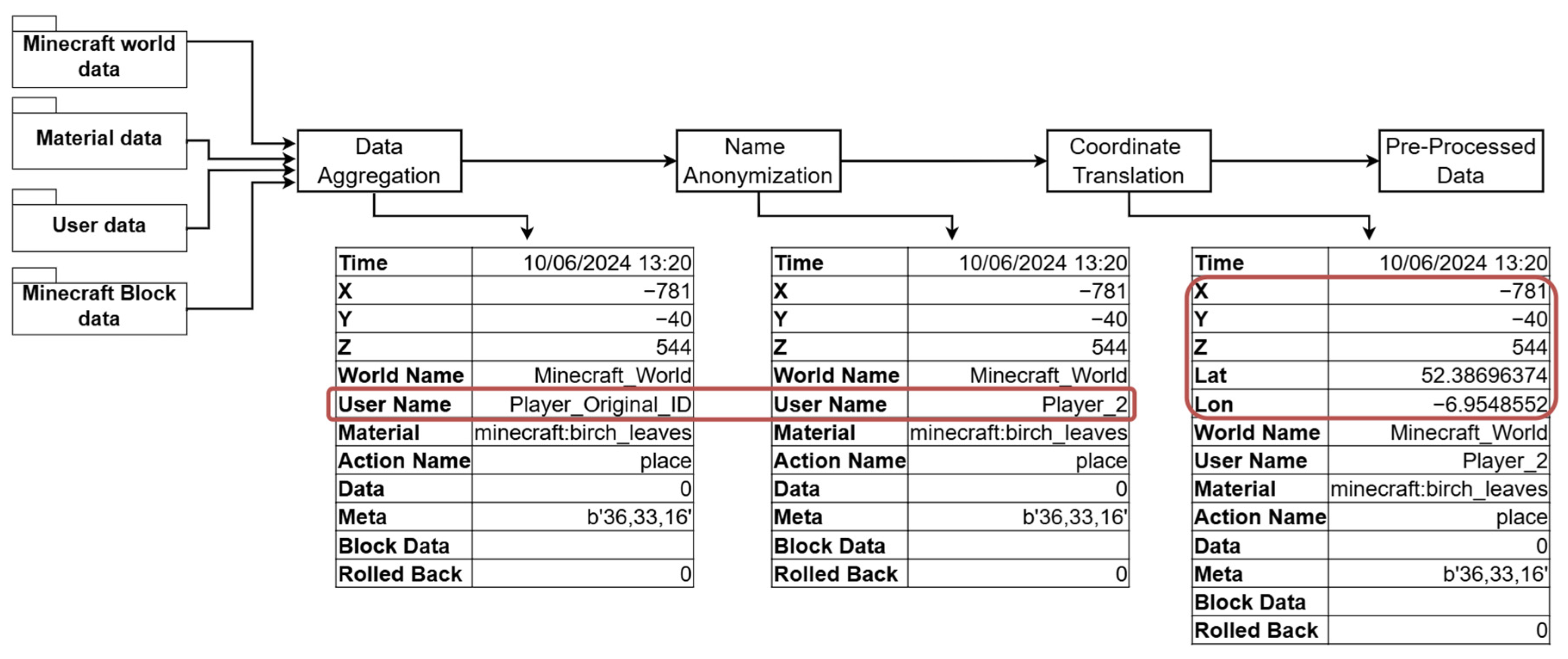
Data acquisition focused on capturing detailed and diverse gameplay interactions to enable comprehensive analysis of player actions within the Minecraft environment. This was facilitated through a dedicated online Minecraft server equipped with custom plugins, namely CoreProtect and WHIMC-PositionTracker [53,54]. CoreProtect comprehensively logged player actions, including block placement, removal, interactions with items, and chat messages. WHIMC-PositionTracker continuously recorded the current location of each player within the Minecraft world, enabling precise tracking of player movements and navigation patterns. The data from these plugins were stored in two separate MySQL databases, ensuring efficient and structured data collection for subsequent phases: data pre-processing and analysis (described in Section 4.3 and Section 4.4). The overall process is illustrated in Figure 2.

Figure 2.
The Minecraft gameplay data analysis pipeline used in the P-PPS.
The CoreProtect plugin offers comprehensive logging functionalities across multiple categories relevant to player activity and environmental dynamics in Minecraft. These functionalities include block logging, which records when players break or place blocks and when blocks move due to in-game physics (e.g., falling sand or gravel); environmental events, such as tree growth and liquid flow are captured, providing insight into dynamic ecological changes; player actions such as chat messages, command usage, and deaths are logged; item logging, that captures item transactions involving containers (e.g., chests, furnaces, dispensers) and logs when players drop or pick up items in the environment; and entity logging such as player-induced entity deaths (e.g., animals, monsters). These aspects are recorded, supporting analyses of combat or resource collection behavior. The spatial gameplay analysis in this study relies heavily on these logging features to reconstruct player activities, material interactions, and environmental engagement.
The P-PPS framework was evaluated through two studies. The first study investigated the implementation of the P-PPS framework by engaging schoolchildren in a Minecraft-based design challenge conducted at a primary school in County Carlow, Ireland. Participants from two different classes (Carlow group 1 and Carlow group 2) were tasked with recreating a local woodland area within the Minecraft world and then proposing interventions to improve the environment. The game-based activity involved an introduction to climate action, a playtest with a land cover design card game, and a collaborative Minecraft activity. For this research, only data collected during the collaborative Minecraft activity is considered. The in-class activity aimed to engage 5th- and 6th-grade students in designing and implementing improvements to a Minecraft replica of the woodland located in front of their school. The students worked in pairs or trios, sharing the same laptop. The online server was accessed using licenses acquired for the project to ensure data privacy and prevent the collection of any personal information.
The second study aimed to assess and validate the P-PPS framework through two co-design workshops with stakeholders with the aim to maximize the representation from across the country. The workshops were organized in Dublin (Co-design workshop 1) and in County Mayo (Co-design workshop 2) as part of the research project introduced in Section 2. The participants, including teachers and local authority representatives (planners, GIS officers, librarians), were introduced to the platform and engaged in discussions on the relevance and potential applications of the collected data, including its use in engagement and consultation processes, as well as in student assessment. This iterative process aimed to gather feedback from stakeholders, refine the framework based on their insights, and explore potential real-world applications.
The participants for the co-design workshops were recruited from local authorities and schools in Ireland. Each session lasted approximately 4 h. The sessions began with a full demonstration of data analysis from study 1, followed by a stakeholder assessment of the relevance of the spatial gameplay analysis. The participants then engaged in a Minecraft activity where they interacted with a virtual representation of Dublin Docklands, planting trees and generating spatial data. The outputs from their gameplay were presented to them, and a second assessment was conducted. The assessment form included eight questions, asking the participants to rate the relevance of different data analysis aspects on a scale of 1 to 4, where 1 is less relevant and 4 is very relevant. These aspects included temporal analysis, spatial analysis (heatmaps), material analysis (type of blocks/items used by players), actions performed by players (break, place, interact), players’ journeys, data visualization UI, geospatial visualization (location of actions), chat log analysis, and overall relevance of the spatial gameplay analysis. The participants were not given their previous ratings.
The participants were informed about the purpose of the research and signed a consent form. The co-design workshops were informed by stakeholder engagement activities developed as part of the Craft-my-Street design thinking process.
4.3. Data Pre-Processing
The data processing transforms raw gameplay data into spatial data by aggregating, anonymizing player identities, and translating in-game coordinates to real-world geospatial formats. Figure 3 illustrates the data pre-processing workflow, starting with data aggregation from multiple tables (e.g., cpro_world, cpro_material_map, cpro_user, and cpro_block) in the database, followed by name anonymization and coordinate translation, ultimately resulting in pre-processed data ready for analysis.
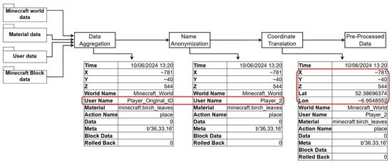
Figure 3.
The data pre-processing workflow used in the P-PPS. The intermediate results are displayed in the table after each sub-process.
4.3.1. Data Aggregation
After the gameplay session concludes, a script is executed to fetch data from the MySQL databases. This program is integral to our data processing workflow as it retrieves gameplay data collected by the CoreProtect and PositionTracker plugins. The program utilizes SQL queries to merge and extract relevant data, providing a comprehensive view of player activities and interactions. Although CoreProtect logs several player actions with entities (blocks), only specific actions, namely, break, place, and interaction are selected for analysis. For the present study, three queries were used to obtain basic gameplay data, chat messages-related data, and user movement-related data.
The basic gameplay data query retrieves detailed information about block actions performed by players, such as block placements, breakages, interactions, and kills. It joins multiple tables to provide a full context of the actions. Additionally, the resulting data consist of Minecraft world-related coordinates (e.g., x, z, y), which need to be translated to real-world coordinate systems, such as WGS-84.
Chat messages-related data query retrieves chat messages exchanged by players, providing insights into in-game communication and coordination. Each message is geo-tagged with the player’s location at the time of sending, adding a spatial layer to the analysis, which enables a deeper understanding of how communication patterns relate to specific areas within the game environment. Additionally, as this game is used by young students, a pre-processing step using the profanity_check 1.4.2 Python library is implemented to detect and filter out inappropriate language, ensuring that the chat data remains suitable and safe for analysis.
Player movement-related data query captures player movement data, an important component for analyzing player interaction with the represented space in the Minecraft world. Given that Minecraft allows teleportation, which can result in abrupt straight-line trajectories in the visualizations, an additional filter is applied to exclude these occurrences. This filtering enhances the accuracy of movement visualizations, ensuring they better reflect natural player navigation and interactions within the game environment.
This systematic data acquisition ensured comprehensive coverage of all gameplay aspects necessary for insightful analysis and visualization.
4.3.2. Name Anonymization
Player anonymity was ensured by replacing their in-game usernames (avatars) with unique identifiers. This step was adhered to protect player privacy, even though real names were not collected directly. This step is important for ethical data handling, ensuring that individual players cannot be personally identified from the data. Player names are anonymized using the Player_<random_number> format, ensuring consistency across the dataset. This means the same player retains the same anonymized identifier throughout the dataset, preventing any possibility of reverse tracking.
This approach complies with best practices for anonymization, which state that pseudonymization should protect individuals’ identities while enabling re-identification within the research context [55,56]. Additionally, as highlighted by Ohm (2010), such practices mitigate privacy risks inherent in research involving potentially identifiable data [57].
4.3.3. Coordinate Translation
Coordinate translation from Minecraft world coordinates to real-world geographical coordinates is achieved through a translation algorithm, available in the data visualization source code as the class ‘GeoConverter’. This algorithm ensures that the x and z coordinates used in Minecraft are accurately converted into latitude and longitude coordinates under the World Geodetic System (WGS-84/EPSG:4326).
To perform this transformation, the algorithm requires the actual map center coordinates (latitude and longitude) and the scale of the Minecraft map, both of which were provided during the map creation process (described in Section 3.1). This transformation allows us to correlate user actions in the game with real-world geographical locations, bridging the gap between virtual interactions and physical spaces [58].
Furthermore, the coordinate transformation facilitates the integration of gameplay data with geospatial visualizations. This integration provides a contextualized view of player activities within defined geographical regions, enhancing the analysis of spatial patterns and behaviors in the game.
4.4. Data Analysis
4.4.1. Temporal Analysis
By leveraging data from the CoreProtect plugin, we analyzed both individual and collective player behavior. Temporal analysis allows the identification of patterns in gameplay, such as peak engagement periods and fluctuations in activity levels over time. The timestamped data were processed using Pandas library, aggregating actions and messages. Using the Matplotlib 3.8.2 library, area plots were generated to visualize activity variations throughout the gameplay, while time-series plots illustrated peak action times.
4.4.2. Geospatial Analysis
Geospatial analysis was used to visualize clusters of actions in the Minecraft world. Heatmaps and block visualizations were overlaid on the OSM base map layer to analyze spatial patterns of player activity and resource use. Heatmaps support the visualization of player interactions, such as high-activity zones or resource-dense regions. By aggregating spatial data points—e.g., the locations of actions like mining, building, or resource gathering—the heatmap highlights hotspots, which reflect areas of high activity within the gameplay. This information can support the understanding of player preferences and behaviors but also aids in improving the in-game activity experience.
Additionally, player movement paths are visualized on the OSM base map to enhance the realism and interpretability of in-game actions. This visualization accurately represents player trajectories while excluding potential teleportation events, ensuring that unrealistic movement patterns are mitigated. The goal is to present a clear and authentic depiction of player movements, improving the overall understanding of gameplay dynamics. The overlay of Minecraft block locations on OSM provides a geographical context that bridges virtual and real-world spatial awareness. By aligning Minecraft data with real-world maps, we can compare in-game building and exploration patterns to familiar geographical markers, adding an additional layer of situational intelligence to the analysis.
4.4.3. Player Activity Analysis
To gain insights into player behavior and activity trends, we conducted a detailed player activity analysis focused on three primary actions: place, break, and interactions/click. This streamlined approach allowed us to capture core gameplay elements, focusing on building, resource gathering, and interactive engagements.
We examined cumulative action counts for each of the three action types, also represented through bar charts. This cumulative perspective revealed dominant gameplay styles. For example, a high frequency of “place” actions indicates a construction-oriented gameplay focus, while frequent “break” actions suggest resource gathering or environmental exploration. Together, these analyses provide a clear view of player engagement and interaction trends, offering valuable insights to inform design decisions and enhance gameplay experiences.
4.4.4. Material Analysis
Material Analysis investigates the types and distribution of materials used by players during gameplay. By analyzing player interactions with various materials, this section explores resource utilization, preferences, and strategic choices, providing insights into how gameplay reflects decision-making and priorities. The analysis was primarily visualized through bar charts, offering an overview of material usage patterns and a comparative perspective on different material types. Additionally, the top ten most frequently used materials were highlighted to emphasize player preferences for specific resources and blocks.
In summary, the Material Analysis contextualizes gameplay actions in terms of resource selection and spatial patterns. This analysis not only highlights the importance of material usage and renewable resources but also provides actionable insights for potential improvements in game design, particularly in fostering environmentally conscious behaviors within the gameplay environment.
A min–max normalization was applied to the material analysis and player actions to facilitate a fair comparison between datasets. This technique transforms values into a fixed range (typically 0 and 1) by adjusting them relative to the minimum and maximum values in the dataset. Min–max normalization is particularly useful when comparing results from different studies that may have varying scales, sample sizes, or units of measurements.
4.4.5. Game Chat Analysis
Game chat analysis offers valuable insights into player communication, strategic thinking, and community engagement within the Minecraft environment. CoreProtect, a tool used in this platform, captures and logs in-game chat messages and commands along with timestamps and location coordinates. These data are essential for understanding how team discussions, strategies, and ideas shared through chat influence subsequent actions and gameplay choices. By analyzing chat data, we can better assess how communication dynamics affect player behavior and collaborative efforts in the game world.
Our approach to game chat analysis involves two primary visualizations. First, we use a word cloud to represent the most frequently used terms in player chat, highlighting key themes of communication and interaction within the Minecraft gameplay environment.
The second visualization method involves mapping chat message locations onto an OSM base map overlay. By displaying chat data in this spatial context, we can observe where conversations take place in relation to in-game location, adding the spatial dimension to the analysis. Together, these visualizations create a comprehensive picture of player interactions, showing not only the content of their conversations but also how and where these discussions shape gameplay. This analysis sheds light on the interplay between communication and player actions, highlighting the importance of team dynamics and shared strategies in the Minecraft experience.
5. Results
This section presents the results of the analyses conducted on players actions and interactions within the Minecraft game environment, with a focus on temporal patterns, spatial dynamics, player activities, resource utilization, and in-game communication.
5.1. Study 1: Schoolchildren
The first study involved 58 schoolchildren participating in two in-class sessions. The students worked in pairs or trios, sharing the same laptop, to recreate a local woodland area in Minecraft. The online server was accessed using project-specific licenses to ensure data privacy and prevent the collection of any personal information.
Temporal analysis revealed distinct patterns in player activity. Carlow Group 1 exhibited lower peaks of activity (between 40 and 80 actions) (Figure 4A), while Group 2 demonstrated less frequent but significantly higher peaks, with a maximum of 1740 interactions within a short interval towards the end of the session (Figure 4B). This high activity rate in Group 2 can be partially attributed to the rapid growth of trees from saplings, with each new block generated contributing to the action count. This phenomenon is further evident in the sapling planting results. Similarly, the use of water buckets significantly impacted action counts. Consequently, water was one of the most frequently used materials in Carlow group 1, alongside grass blocks and oak logs used by both groups (Figure 7A,B). The type of used material reflects the context of the in-game task, which was focused on regrowing a woodland area. Despite its low overall frequency (Figure 7A), Carlow group 1 made significant use of white wool (355 blocks). This material was used by this group in reconstructing real structures presented in the area but missing in the OSM data. This highlights the potential of such a framework for enriching existing datasets with information that reflects the local knowledge of a place.
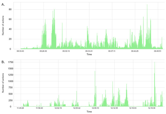
Figure 4.
Area graphs illustrating player interactions over time. The graphs show the number of actions performed by (A) Carlow group 1 and (B) Carlow group 2. Peaks in the graphs indicate the high activity periods within the Minecraft environment.
Spatial analysis demonstrated that both groups engaged in block placement and removal within and outside the designated woodland area. Most saplings were planted within the marked area (Figure 5A,B). The heatmap analysis revealed that Group 2 exhibited more widespread interaction with the surrounding environment, including the Sugar Factory site, with high activity observed in the southern part of the woodland where they constructed a house structure (Figure 5D). This observation is corroborated by player movement data, which showed that one player in Group 2 consistently focused their activity in this specific area (Figure 5F).
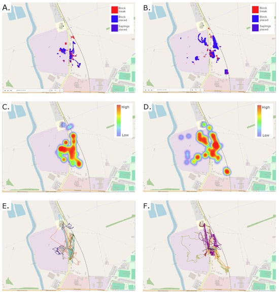
Figure 5.
Geospatial visualization of player actions and zones. (A,B) show the geospatial visualization of actions for Carlow group 1 and Carlow group 2, respectively. (C,D) display the geospatial visualization of action zones (hot and cold spots) for Carlow group 1 and Carlow group 2, respectively. (E,F) illustrate player journeys for Carlow group 1 and Carlow group 2, respectively, where each color represent one player. Base map source: OpenStreetMap Contributors.
The analysis of sapling usage and tree planting activities provided insights into player actions and preferences. The sapling Species Distribution indicated a clear preference for oak (Carlow Group 1) and birch (Carlow Group 2) saplings, likely reflecting their relevance within the Minecraft environment and their ease of use (a single sapling grows into a full tree). Carlow Group 1 planted four types of trees (Figure 8A), while Carlow Group 2 utilized five different tree species, with a higher frequency of saplings planted per type (Figure 8B). Spatial visualization revealed that sapling planting was distributed across various regions of the game world, with noticeable concentrations within the designated woodland area.
Carlow Group 1 exhibited a distinct pattern of activity. The participants primarily focused on planting trees within the designated woodland area, demonstrating a strong adherence to the assigned task (Figure 5A). Notably, there was a preference for oak saplings (Figure 8A) across both groups, possibly because it is perceived as the classic or default tree type in Minecraft. However, tree planting was relatively dense, suggesting a potential focus on quantity over spatial distribution. Players 5 and 8 were the most active contributors, with Player 8 demonstrating particularly high levels of engagement (Figure 6A). The analysis revealed that the majority of actions performed by this group were “PLACE”, indicating a strong emphasis on construction and environmental modification.
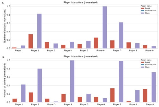
Figure 6.
Bar chart illustrating the number of actions per player (pair or trio of students) for (A) Carlow group 1 and (B) Carlow group 2.
Figure 6.
Bar chart illustrating the number of actions per player (pair or trio of students) for (A) Carlow group 1 and (B) Carlow group 2.
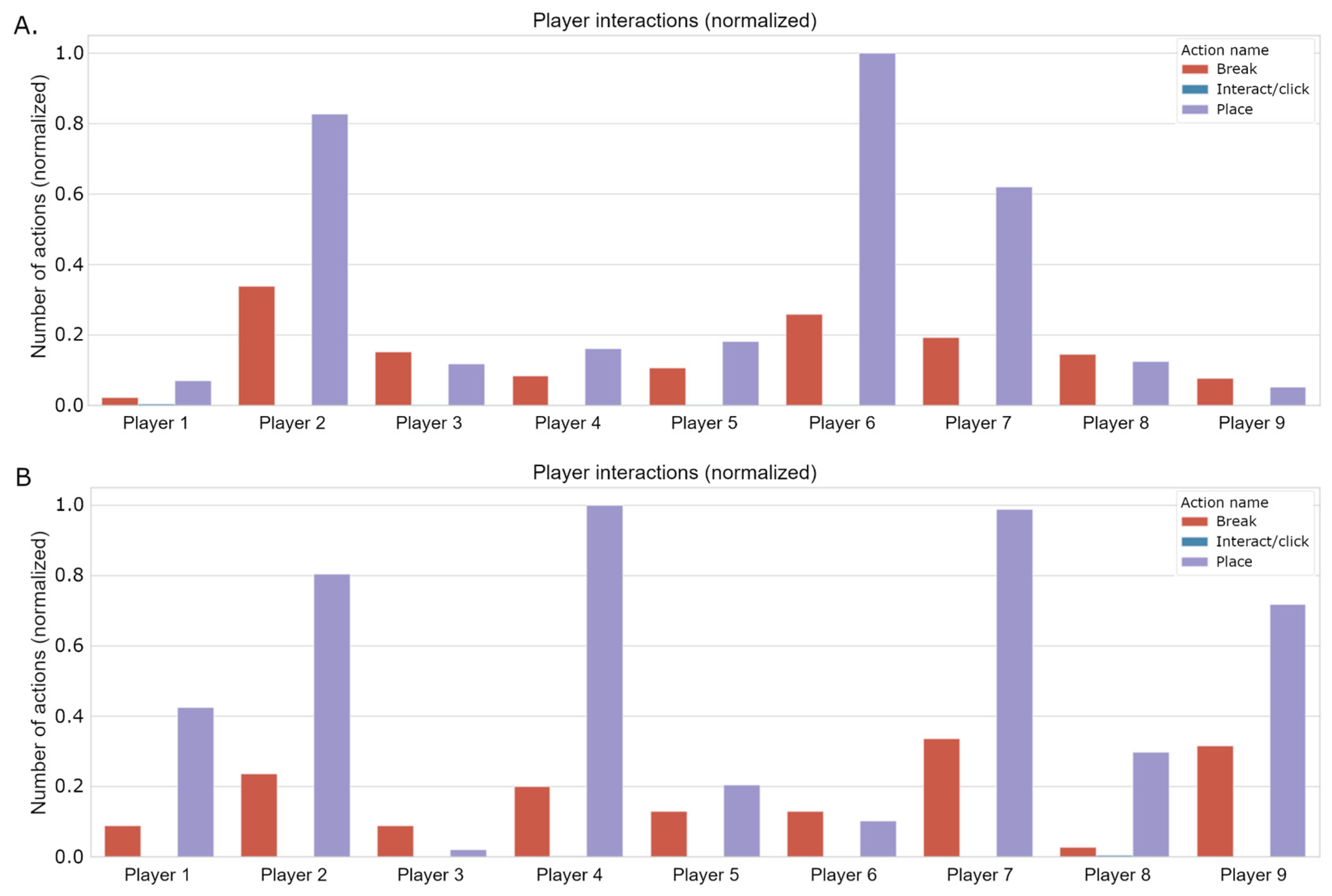
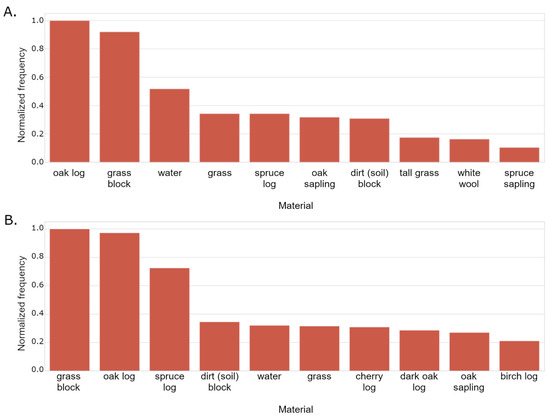
Figure 7.
Bar chart illustrating the frequency of use of materials for (A) Carlow group 1 and (B) Carlow group 2.
Figure 7.
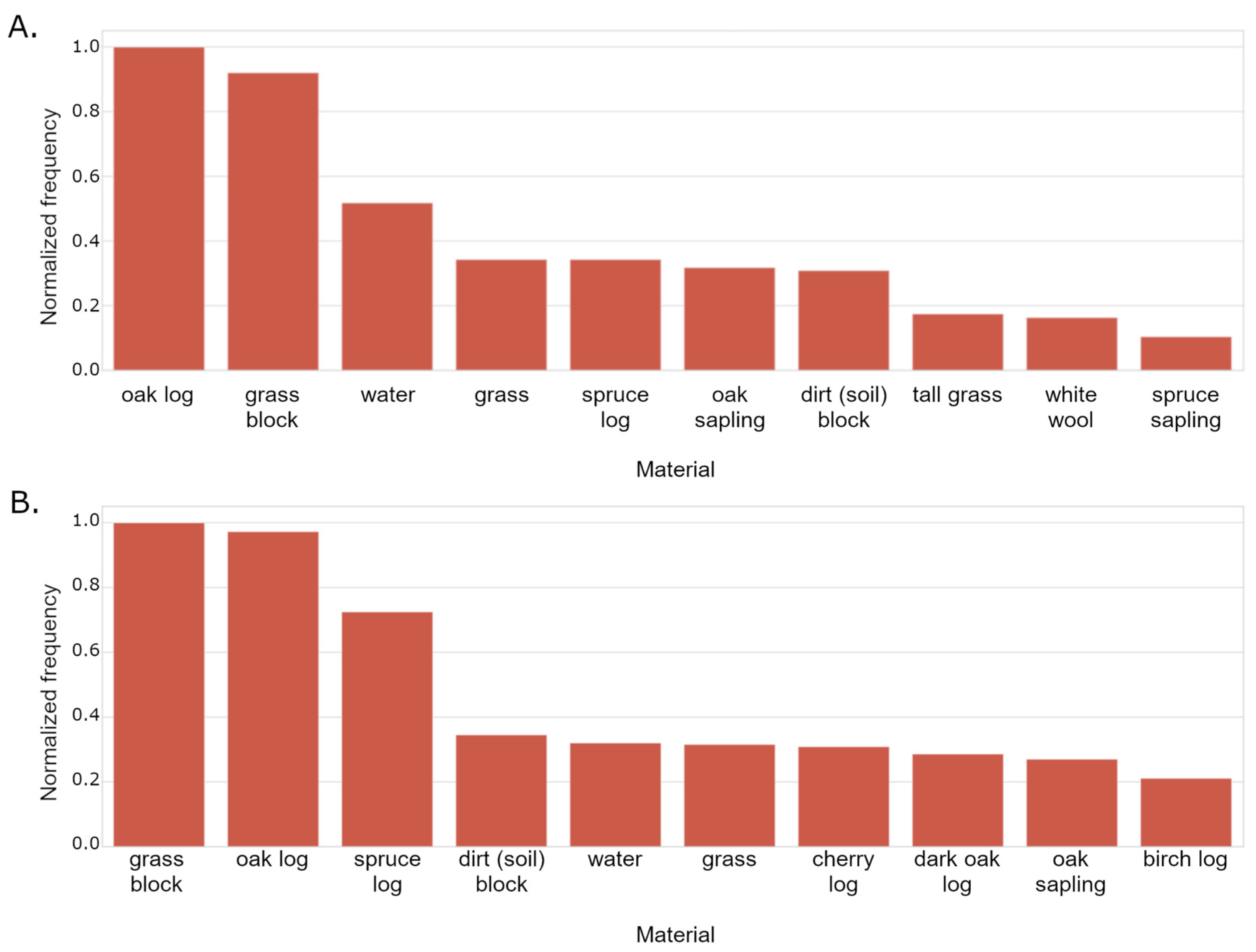
Bar chart illustrating the frequency of use of materials for (A) Carlow group 1 and (B) Carlow group 2.
Carlow Group 2 demonstrated a different pattern of activity. While they also engaged in significant tree planting, using a wider variety of species (Figure 8B) compared to Group 1, the preference for oak remained, and their activity was more dispersed (Figure 5B). Some players ventured outside the designated woodland area, exploring and interacting with other parts of the game world, including the Sugar Factory Site. Notably, Players 1, 2, and 4 were the most active, collectively planting over 82% of the total saplings (Figure 6B). Furthermore, one player exhibited significantly more exploratory behavior, venturing further afield and engaging in more extensive exploration of the Sugar Factory Site and the southern parts of the woodland area (Figure 5F).

Figure 8.
Bar chart illustrating the frequency of use of tree sapling species for (A) Carlow group 1 and (B) Carlow Group 2.
Figure 8.
Bar chart illustrating the frequency of use of tree sapling species for (A) Carlow group 1 and (B) Carlow Group 2.

Chat analysis revealed differences in communication patterns between the two groups. Carlow Group 1 frequently used words like “building”, “animal”, and “water” in their chat messages, indicating a focus on construction and environmental interactions (Figure 9A). In contrast, Carlow Group 2 exhibited less interaction within the game chat related to the in-game activity (Figure 9B). This difference can be attributed to the social dynamics within the classroom, as students were likely engaging in verbal communication with their peers while playing the game. Despite players being oriented to use the chat responsibly, some attempted to surpass the chat filter system. These instances were identified, and their teacher was notified during the session to mediate the situation.

Figure 9.
Word clouds representing the most frequently used terms in player chat from (A) Carlow group 1 and (B) Carlow Group 2.
5.2. Study 2: Co-Design with Stakeholders
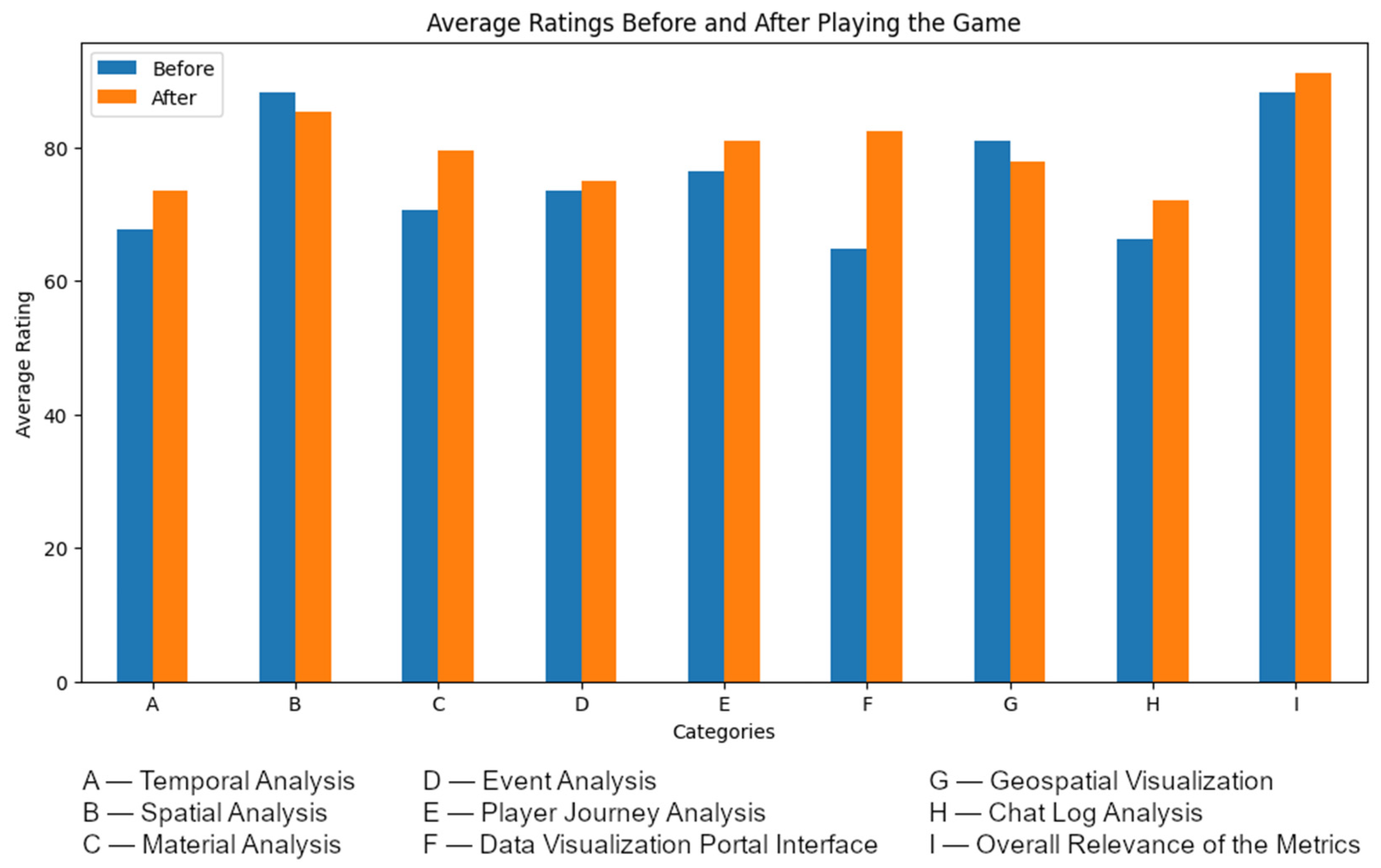
Two co-design workshops were conducted, involving a total of 18 participants (5 in workshop 1 and 13 in workshop 2) comprising teachers and local authority representatives. The workshops aimed to assess and validate the P-PPS framework through an iterative process. The participants were introduced to the P-PPS and the spatial gameplay analysis framework, including outputs from Study 1, through a presentation. Subsequently, an assessment form was provided to evaluate the relevance of each analysis (Figure 10).
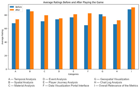
Figure 10.
Results of the pre (blue) and post (orange) assessment forms with stakeholders, highlighting initial preference for graph-based analyses (A, C, H) and the subsequent recognition of the value of spatial analysis (G, E).
Following the presentation, the participants engaged in a Minecraft playtest within a virtual representation of the Dublin Docklands. In workshop 1, the participants individually explored the environment, while in workshop 2, they worked in pairs. This hands-on experience allowed participants to interact with the virtual environment and experiment with in-game actions, such as planting trees. After the playtest, the participants were presented with the same assessment form to re-evaluate the relevance of the spatial gameplay analysis. A final debriefing session was conducted to discuss the potential applications of the P-PPS framework, the generated data, and the challenges encountered.
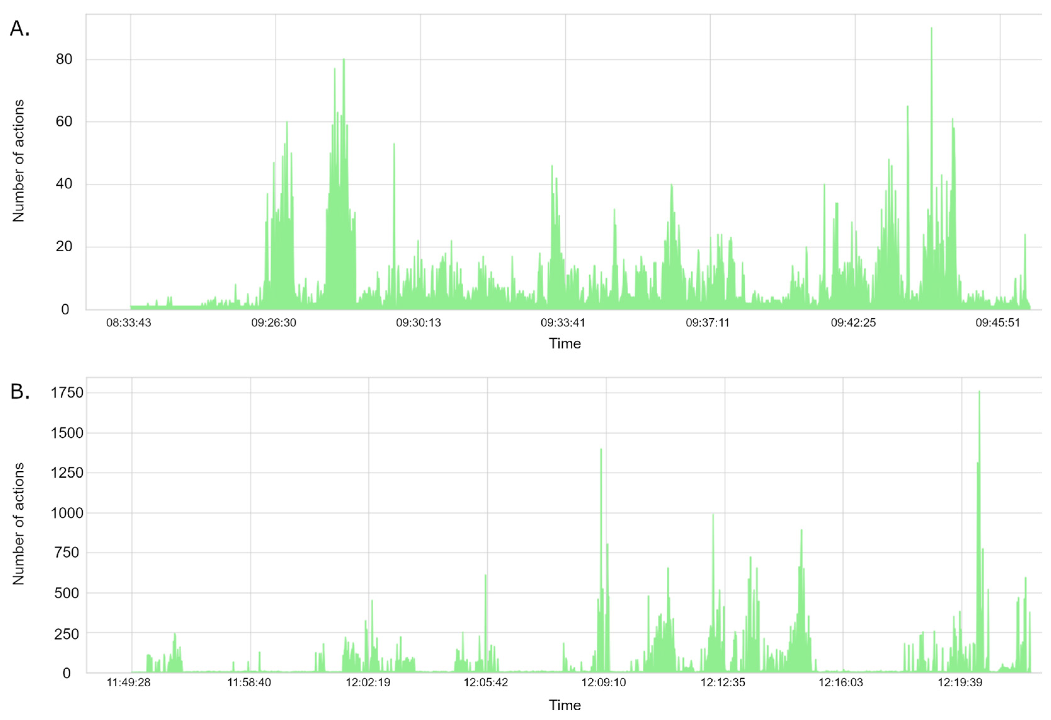
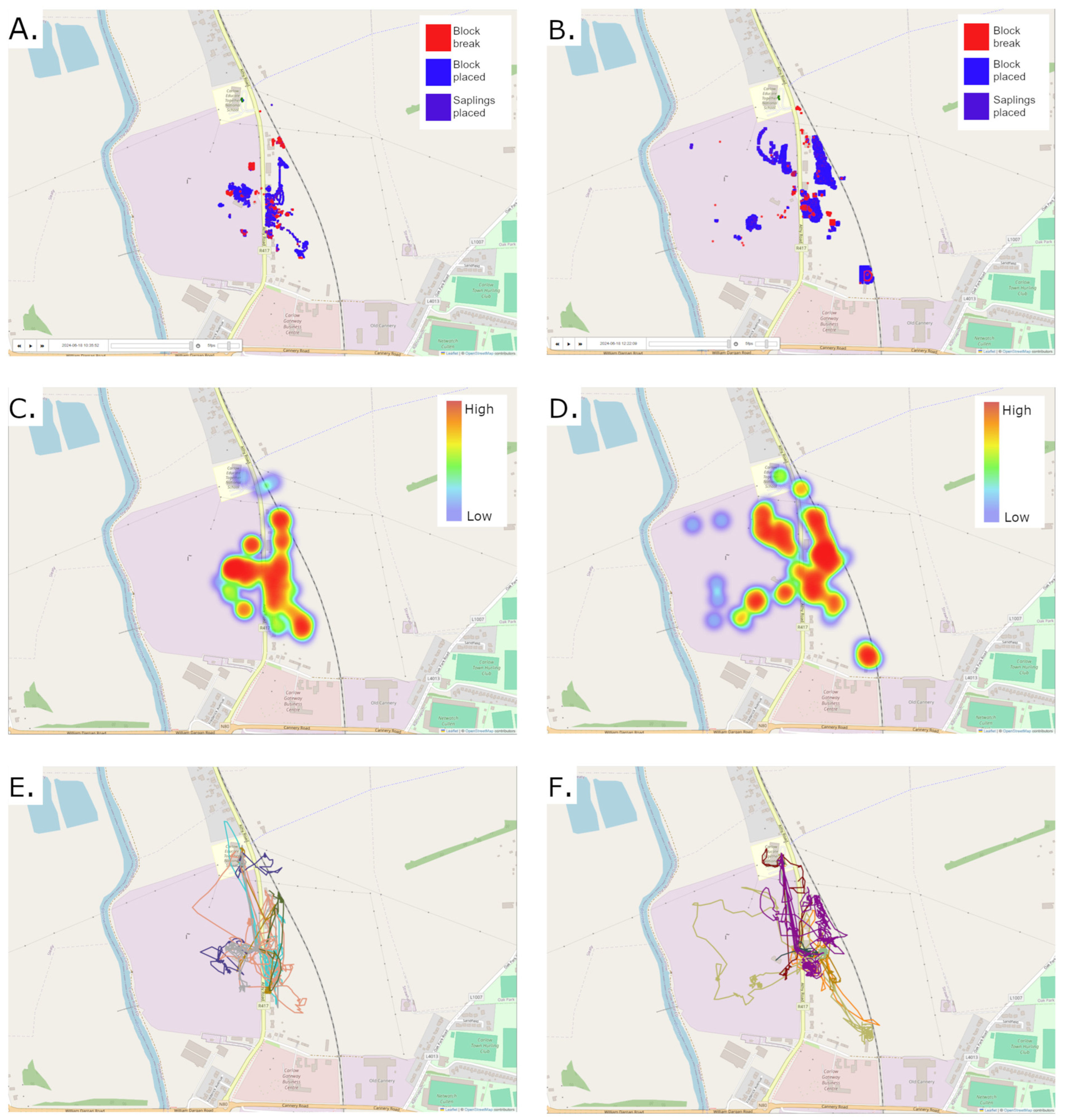
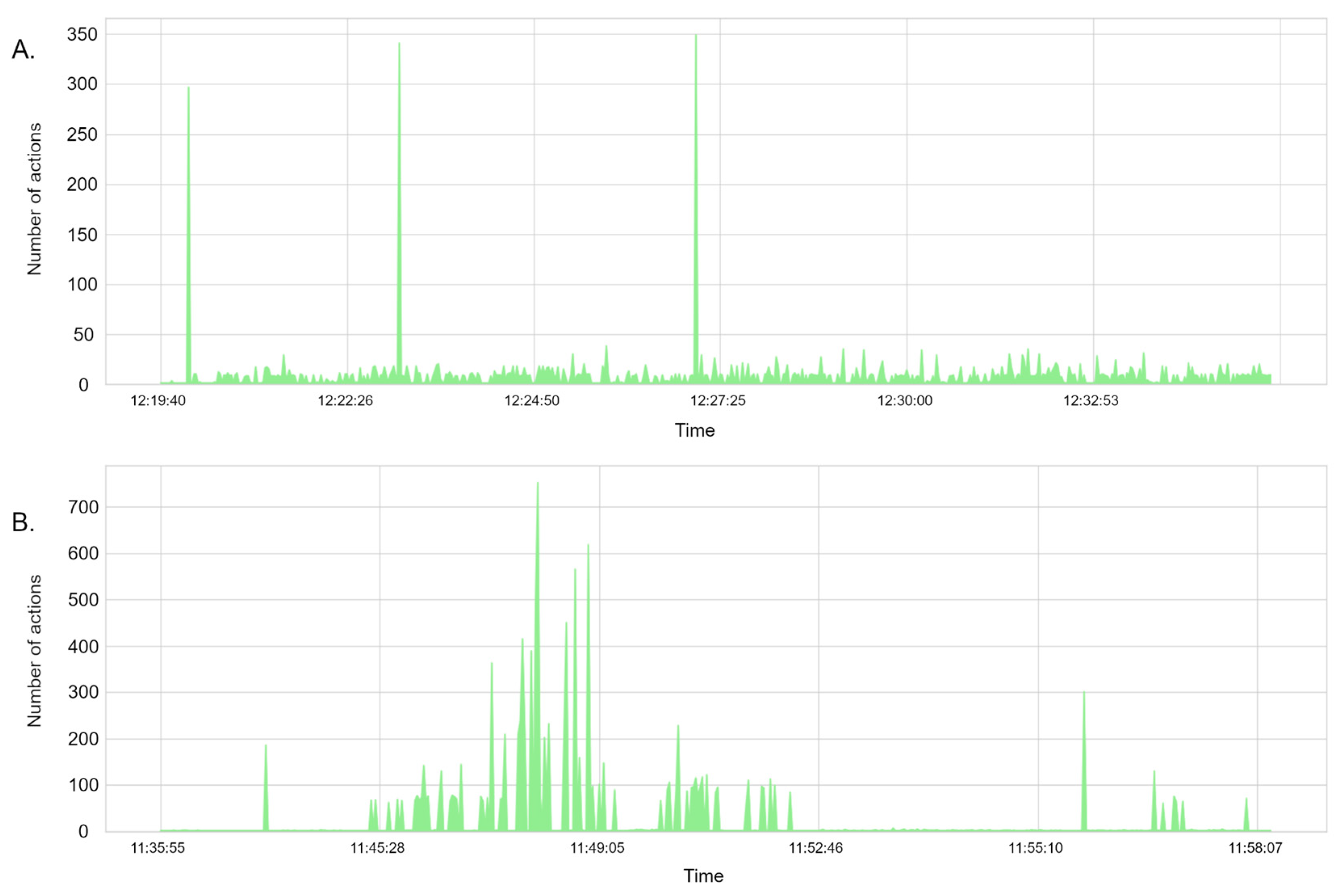
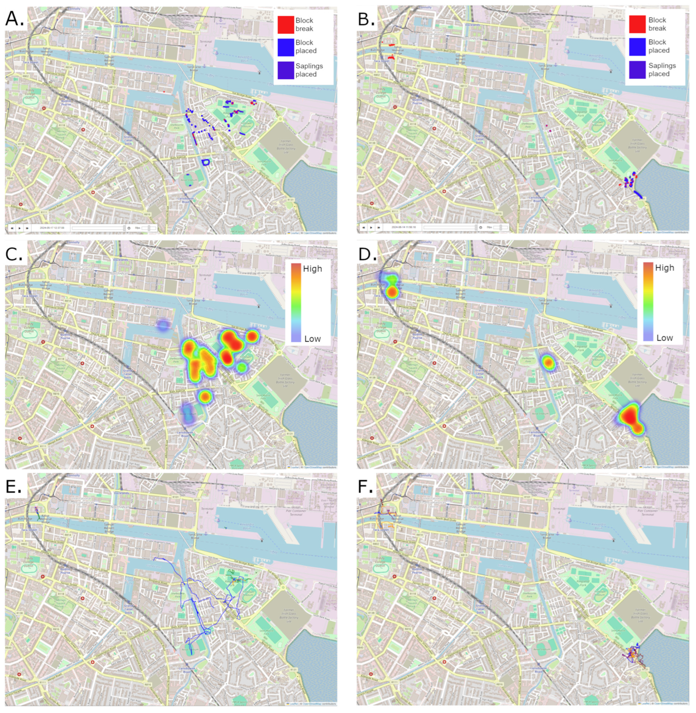
Workshop 1 exhibited three action peaks, possibly due to sapling growth, alongside a consistent, though less pronounced, level of activity across the session (Figure 11A). In contrast, workshop 2’s group showed a surge in activity after the initial 10 min used for instructing participants on how to play the game (Figure 11B). Spatial analysis revealed that players in both workshops concentrated their actions around their initial spawn points in Ringsend and Sandymount (Figure 12C,D). Player activity patterns reflected real-world features, aligning with park areas, street lines, and water bodies. This was evident in both action locations (Figure 12A,B) and player movement data (Figure 12E,F), with participants in workshop 1 exhibiting a wider range of interaction within the game environment compared to those in workshop 2.
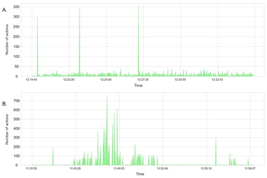
Figure 11.
Area graphs illustrating the temporal patterns of player activity, measured by the number of actions, recorded during (A) Co-design workshop 1 and (B) Co-design workshop 2.
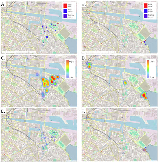
Figure 12.
Geospatial visualization of actions of (A) Co-design workshop 1 and (B) Co-design workshop 2. Geospatial visualization of action zones (hot and cold spots) for (C) Co-design workshop 1 and (D) Co-design workshop 2. Geospatial visualization of player journeys for (E) Co-design workshop 1 and (F) Co-design workshop 2, where each color represent one player. Base map source: OpenStreetMap Contributors.
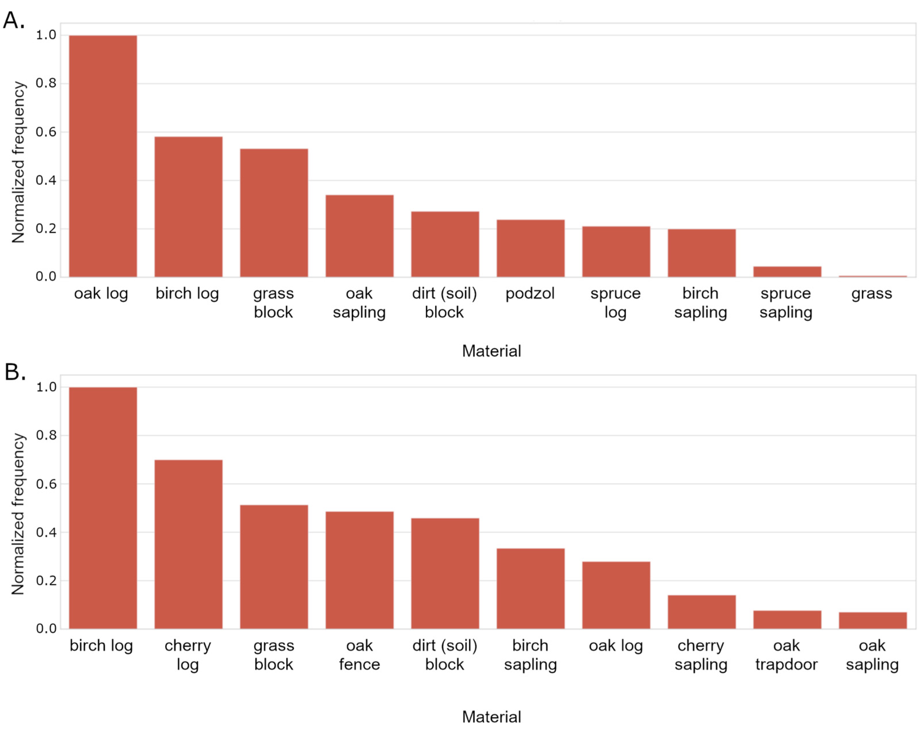
Material analysis demonstrated distinct preferences between the two workshops. The participants in workshop 2 utilized a greater variety of materials, particularly planting a significantly higher number of cherry and birch trees compared to workshop 1 (Figure 13B). In contrast, the participants in workshop 1 primarily planted oak trees (Figure 13A).
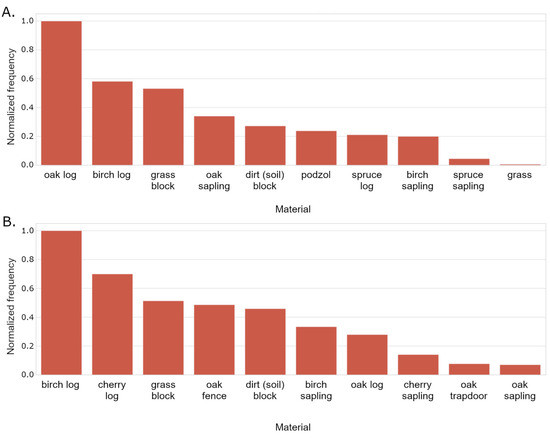
Figure 13.
Bar chart illustrating the frequency of use of materials for (A) Co-design workshop 1 and (B) Co-design workshop 2.
Chat analysis revealed that both workshops utilized words related to the activity, such as “trees” and “planting”. However, the participants in workshop 1 exhibited more frequent and diverse communication within the chat, including discussions about “planning”, “shade”, “visitors”, and “gardens” (Figure 14A), indicating an interest around the associated values to their interventions.

Figure 14.
Word clouds representing the most frequently used terms in player chat from (A) Co-design workshop 1 and (B) Co-design workshop 2.
The results from the pre- and post-playtest assessments revealed a higher perceived relevance for graph-based analyses, such as temporal, material, and chat analysis, which do not explicitly rely on spatial visualization (Figure 10). This finding may suggest that stakeholders, with potential experience in analyzing charts and graphs, found these non-spatial data representations more readily interpretable and potentially more relevant to their existing workflows.
The workshops successfully validated the relevance of various data analysis approaches. Stakeholders initially showed higher interest in graph-based analyses, such as temporal, material, and chat analysis, likely due to their familiarity with interpreting charts. Following the gameplay activity and subsequent data visualization, stakeholders recognized the significant value of spatial analysis, including heatmaps and player movement data, in understanding player interactions and preferences within the Minecraft environment.
Stakeholders identified several potential real-world applications for the collected data. These include informing urban planning decisions based on how player preferences and design choices can inform decisions related to infrastructure development, green space allocation, and public space improvements; improving citizen engagement as the P-PPS framework can be used to enhance public participation in urban planning processes by providing an interactive and engaging platform for citizen input; and supporting educational initiatives by integrating the P-PPS into educational programs to teach students about urban planning, environmental issues, and the use of digital tools for civic engagement.
Stakeholders emphasized the importance of addressing potential challenges, such as managing large volumes of data and ensuring the accessibility and usability of the platform for diverse user groups. The need for clear communication and stakeholder engagement throughout the entire process was highlighted, including involving stakeholders early on in the design and development of the P-PPS framework.
6. Discussion
While other sources discuss digital tools for urban planning [1,7,59], participatory GIS [6], and the use of games like Minecraft in education or geodesign [22,27,37,38], our work introduces a distinct and structured approach to their specific intersection. This study extends prior research by addressing a gap in the existing literature: the systematic transformation of player actions within Minecraft back into geospatial data for analysis, a reverse process largely underexplored compared to the creation of Minecraft environments from geospatial data. Unlike previous studies that often lacked a strong emphasis on analyzing player-generated spatial data within virtual replicas of specific real-world locations [19,22,23,24,25,26,27,39], this research leverages OSM data to create such environments and subsequently analyzes player interactions within them in direct relation to these locations. This framework offers a concrete method for leveraging Minecraft as a game environment for geospatial data collection.
Although the majority of the interactions recorded in the game are block interactions, and placement of saplings, this gives us insights into possibilities how geospatial data can be used as input and produced as output of the gameplay. The restrictive nature of the gameplay we imposed on the user was partly to allow us to test a number of data storage approaches, and to develop a means to view these analytics on the fly, and for post processing. Through trialing a number of Minecraft plugins across workshops and in-class activities, we wanted the tasks to be both repetitive across activities, and allow engagement across all levels of user, from those with no experience with Minecraft, to those who regularly play. Thus, the activities performed as part of the experimental design focused on testing the data collection approach. Future research can benefit from in-game tasks designed to achieve more comprehensive scenarios to better map real-world planning challenges.
Analysis of the data from the climate action-themed activity with school children revealed discernible patterns in their engagement, including localized action densities and preferences for specific in-game elements. Furthermore, co-design workshops with educators and local authority representatives validated the relevance of employing spatial analysis techniques to interpret player interactions and preferences within Minecraft. Stakeholder feedback also highlighted promising real-world applications for the collected data, particularly in informing urban design and planning processes and enriching educational initiatives. The study’s insights into player strategies, community interactions, and resource management within the game environment could inform the design of more engaging and effective learning experiences, as also pointed out by Mueller et al. [30] and Schöbel et al. [36].
Regarding children’s participation in decision-making, the P-PPS offers a practical digital methodology for enacting the principles of children participation, particularly those outlined in frameworks like the Lundy Model [15] which is relevant to Ireland’s approach [14]. While the Irish framework for participation discusses the importance of hearing the voice of the child in various contexts and at different levels of decision-making, including through permanent structures like child and youth councils, the P-PPS provides a specific tool to facilitate this. The study with school children and the co-design workshops with stakeholders exemplify this. The P-PPS also facilitates the Voice of children and young people through their in-game actions and chat communication, as demonstrated by the schoolchildren’s spatial design choices and the analysis of material usage and spatial distribution. The analysis of chat interactions further highlights their verbal “Voice” and aligns with the concept of analyzing different modalities of data in learning environments as highlighted by Emerson et al. [42].
The P-PPS framework is designed to capture and analyze player-generated data, making it available to the “Audience” of decision-makers like county planners, as evidenced by the presentation of gameplay data to stakeholders in the co-design workshops. This addresses the need for clearer structures and frameworks to enable children’s participation in local planning processes, as argued by Usher [32].
While the pilot studies primarily focused on data collection, the potential for the P-PPS to exert “Influence” on real-world decisions is a key objective, with stakeholders identifying applications in urban planning and education, aligning with Ireland framework’s vision of “participation with purpose” [14], while aligning with its overarching principles of transparency, voluntary, respectful, relevant, child-friendly, and striving for inclusivity, safety, and accountability.
This research also aligns with the emerging Planning 3.0 paradigm [7], recognizing the increasing impact of digital participatory practices in spatial planning, and directly addresses the ongoing discourse surrounding the meaningful inclusion of children and young people in planning processes, particularly within the context of Ireland’s national framework [14]. The P-PPS offers a tangible methodology for public sector bodies to potentially realize these commitments by harnessing the engaging nature of serious games like Minecraft.
6.1. Limitations
Limitations should be considered when interpreting the findings of this study. Regarding data collection, the collaborative nature of gameplay among schoolchildren, who often worked in pairs or trios on a single laptop, potentially reduced the granularity of individual player action data, making it difficult to precisely attribute actions to specific individuals and potentially skewing individual behavior metrics. Additionally, the inherent challenges in managing online interactions within the Minecraft environment introduced variability in data collection conditions due to unmanaged interactions, highlighting the need for robust moderation strategies. The analysis of chat interactions also revealed a limitation in the current filtering mechanism’s ability to exhaustively detect and remove inappropriate language, potentially affecting the overall quality and suitability of the chat data for all analytical purposes.
Methodologically, the observed tendency for high action density within limited areas during the schoolchildren study suggests that the current approach might not inherently promote or capture data related to broader spatial exploration or large-scale planning considerations without explicit guidance. The initial preference expressed by stakeholders for graph-based analyses over spatial visualizations indicates a potential limitation in the methodology’s immediate ability to convey the interpretability and value of spatially referenced player-generated data without direct hands-on experience.
The simplified representation of real-world locations during Minecraft world generation from OSM data, involving scaling and exaggeration of building heights, introduces an inherent level of abstraction that could limit the direct transferability of highly detailed spatial analyses to real-world scenarios. Additionally, level of detail depends on data availability in the OSM database, such as building heights, number of stories, trees, etc. This could be overcome by exploring the inclusion of official databases in the Minecraft world generation process.
In terms of scalability, stakeholders identified potential challenges associated with managing large volumes of data as participant numbers and activity durations increase, potentially straining current storage, processing, and analysis capabilities. Ensuring the accessibility and usability of the platform for diverse user groups also presents a challenge for wider adoption, as the current interface and tools may require further refinement to accommodate users with varying technical proficiencies. Finally, the expressed need for a more interactive and dynamic data analysis platform with enhanced features suggests that the current analytical tools may limit the ability of educators and other stakeholders to conduct in-depth and customized analyses of player-generated data at scale.
6.2. Future Research
Future research should prioritize key areas to advance the findings and address the limitations of this study. A primary focus should be on enhancing the data analysis and visualization platform by integrating more dynamic filtering options and interactive features to enable more nuanced insights into player interactions and their participation in spatial design processes.
The implementation of a more robust filtering mechanism for chat interactions is essential, particularly when the platform involves young students, to ensure a safe and educational online environment. Future work should also look into the deeper exploration and design of in-game activities that enhance player engagement through participatory gameplay mechanics, potentially involving a more intricate integration of Minecraft’s environmental elements and resource management tasks to further encourage environmentally conscious behaviors.
Expanding the application of the P-PPS to facilitate localized analyses and the development of customized citizen engagement and participatory planning strategies presents another promising avenue for research. This includes the creation of interactive, immersive experiences designed to educate students and empower communities to propose and visualize solutions for their specific neighborhoods, particularly concerning critical issues like climate change and sustainability.
7. Conclusions
This research contribution relies on establishing and validating the Playful Participatory Planning System (P-PPS) as a pioneering framework that transforms how player-generated data within Minecraft’s virtual environment can inform real-world urban planning, in the perspective of Ireland’s framework for children participation in decision-making. Its efficacy is demonstrated through both young people and adult stakeholders, offering an inclusive methodology for engaging diverse communities in spatial design. The insights gained into children’s environmental design preferences and the validation of spatial analysis by planning professionals underscore the P-PPS’s potential to move beyond traditional engagement methods, providing actionable geospatial data that can directly influence planning decisions and enrich educational initiatives. The study addresses a key gap by enabling the systematic translation of in-game actions back into real-world geospatial data, offering a novel and scalable digital pathway for enacting meaningful child participation in decision-making processes and ensuring their spatial perspectives are considered in shaping future urban landscapes.
For practical applications, the P-PPS framework has several important policies and practical implications. In the context of Ireland, the P-PPS can contribute to the implementation of national digital strategies such as Connecting Government 2030, as well as providing means for local authorities to adhere to the National Framework for Children and Young People Participation in Decision-making when consulting citizens on projects. Its use opens new opportunities to assess and co-design national and local policies that influence children and young people’s lives, by providing mechanisms to communicate and validate policy implementation.
The P-PPS is recommended to urban planners who want to enhance citizen engagement and integrate children and young people’s views in informed decision-making processes, as the site-specific capabilities of the platform can facilitate communication and consultation on local-level projects. Educators can incorporate the P-PPS into curricula for teaching urban planning and environmental concepts, leveraging gameplay analytics for assessment while guiding students towards comprehensive and ecological design thinking.
Future work will prioritize the development of a more dynamic and interactive data analysis platform, with improved filtering and visualization capabilities to better inform decision-making. This includes designing more engaging and comprehensive in-game tasks that encourage broader spatial exploration and environmentally conscious behaviors, while also implementing robust moderation strategies to ensure safe and productive online interactions. Refining the Minecraft world generation process by exploring the integration of official datasets for greater accuracy and detail is also a relevant topic to be explored, as level of detail can be a factor in supporting the player’s understanding of the represented real space. Finally, developing recommendation systems based on player data and addressing the challenges of data scalability and platform accessibility for diverse user groups are steps for future development and wider adoption of the P-PPS.
Author Contributions
Conceptualization, Chiara Cocco and Ítalo Sousa de Sena; methodology, Ítalo Sousa de Sena and Lasith Niroshan; software, Lasith Niroshan; validation, Chiara Cocco, Lasith Niroshan and Ítalo Sousa de Sena; formal analysis, Lasith Niroshan; investigation, Lasith Niroshan and Ítalo Sousa de Sena; resources, Chiara Cocco; data curation, Lasith Niroshan, Ítalo Sousa de Sena and Micheál Butler; writing—original draft preparation, Lasith Niroshan and Ítalo Sousa de Sena; writing—review and editing, Chiara Cocco, Ítalo Sousa de Sena, Lasith Niroshan, Jonáš Rosecký, Vojtěch Brůža and Micheál Butler; visualization, Lasith Niroshan, Ítalo Sousa de Sena and Micheál Butler; supervision, Chiara Cocco, Ítalo Sousa de Sena; project administration, Chiara Cocco; funding acquisition, Chiara Cocco. All authors have read and agreed to the published version of the manuscript.
Funding
This publication has emanated from research conducted with the financial support of Taighde Éireann—Research Ireland under Grant number 22/NCF/OT/11150.
Institutional Review Board Statement
This study received ethical approval from the Human Research Ethics Committee at University College Dublin (approval numbers: LS-24-16-Cocco: Craft-my-Participation—Children and young people’s engagement in decision-making through playful experiences; LS-LR-23-180-Cocco: Craft-my-Street—Capacity building of local government for youth engagement in decision-making through geospatial data and games).
Data Availability Statement
The source code for the spatial gameplay analysis framework developed in this research is available on GitHub at https://github.com/craft-my-street/minecraft-data-viz-platform (accessed on 19 April 2025).
Acknowledgments
The authors gratefully acknowledge the OpenStreetMap Community for providing the open-source geospatial data used in this research, as well as CoreProtect developers and WHIMC Project for distributing the plugins used in this research.
Conflicts of Interest
The authors declare no conflicts of interest.
Abbreviations
The following abbreviations are used in this manuscript:
| OSM | OpenStreetMap |
| P-PPS | Playful Participatory Planning System |
| UN | United Nations |
| UCD | University College Dublin |
References
- Hasler, S.; Chenal, J.; Soutter, M. Digital Tools as a Means to Foster Inclusive, Data-informed Urban Planning. Civ. Eng. Archit. 2017, 5, 230–239. [Google Scholar] [CrossRef]
- Rucker, D.G. Online Public Participation Platforms and Applications (Overview); White Paper-Wise Econ. 2014. Available online: https://comdev.osu.edu/sites/comdev/files/imce/Online%20Public%20Participation%20Platforms%20and%20Applications%20-%20white%20paper.pdf (accessed on 14 April 2025).
- Ganuza, E.; Francés, F. The deliberative turn in participation: The problem of inclusion and deliberative opportunities in participatory budgeting. Eur. Polit. Sci. Rev. 2012, 4, 283–302. [Google Scholar] [CrossRef]
- Reiter, P. Participatory Budgeting in Porto Alegre. J. Für Entwicklungspolitik 2004, 20, 85–94. [Google Scholar] [CrossRef]
- McKinley, E.; Crowe, P.R.; Stori, F.; Ballinger, R.; Brew, T.C.; Blacklaw-Jones, L.; Cameron-Smith, A.; Crowley, S.; Cocco, C.; O’Mahony, C.; et al. ‘Going digital’-Lessons for future coastal community engagement and climate change adaptation. Ocean. Coast. Manag. 2021, 208, 105629. [Google Scholar] [CrossRef]
- Brown, G.; Kyttä, M. Key issues and research priorities for public participation GIS (PPGIS): A synthesis based on empirical research. Appl. Geogr. 2014, 46, 122–136. [Google Scholar] [CrossRef]
- Potts, R. Is a New ‘Planning 3.0’ Paradigm Emerging? Exploring the Relationship between Digital Technologies and Planning Theory and Practice. Plan. Theory Pract. 2020, 21, 272–289. [Google Scholar] [CrossRef]
- Arnstein, S.R. A Ladder Of Citizen Participation. J. Am. Inst. Plann. 1969, 35, 216–224. [Google Scholar] [CrossRef]
- Kingston, R.; Carver, S.; Evans, A.; Turton, I. Web-based public participation geographical information systems: An aid to local environmental decision-making. Comput. Environ. Urban Syst. 2000, 24, 109–125. [Google Scholar] [CrossRef]
- Carver, S. Participation and Geographic Information: A Position Paper; ESF-NSF Workshop on Access to Geographic Information and Participatory Approaches Using Geographic Information: Spoleto, Italy, 2001. [Google Scholar]
- Campagna, M.; Steinitz, C.; Di Cesare, E.A.; Cocco, C.; Ballal, H.; Canfield, T. Collaboration in planning: The Geodesign approach. Rozw. Reg. I Polityka Regionalna 2016, 35, 55–72. Available online: https://pressto.amu.edu.pl/index.php/rrpr/article/view/8574 (accessed on 19 April 2025).
- Rodela, R.; Norss, E. Opening up spatial planning to the participation of children and youth: The Swedish experience. Eur. Plan. Stud. 2022, 31, 252–269. [Google Scholar] [CrossRef]
- UN Committee on the Rights of the Child. General Comment No. 26 (2023) on Children’s Rights and the Environment with a Special Focus on Climate Change (CRC/C/GC/26); Office of the United Nations High Commissioner for Human Rights.7); Springer: Berlin/Heidelberg, Germany, 2023. [Google Scholar]
- Department of Children, Equality, Disability, Integration and Youth (DCEDIY). Participation Framework: National Framework for Children and Young People’s Participation in Decision-Making; Government of Ireland: Dublin, Ireland, 2024. Available online: https://hubnanog.ie/wp-content/uploads/2023/06/5587-Child-Participation-Framework_report_LR_FINAL_Rev.pdf (accessed on 14 April 2025).
- Lundy, L. ‘Voice’ is not enough: Conceptualising Article 12 of the United Nations Convention on the Rights of the Child. Br. Educ. Res. J. 2007, 33, 927–942. [Google Scholar] [CrossRef]
- Devisch, O.; Poplin, A.; Sofronie, S. The Gamification of Civic Participation: Two Experiments in Improving the Skills of Citizens to Reflect Collectively on Spatial Issues. J. Urban Technol. 2016, 23, 81–102. [Google Scholar] [CrossRef]
- Poplin, A.; de Andrade, B.; de Sena, Í. Let’s discuss our city! Engaging youth in the co-creation of living environments with digital serious geogames and gamified storytelling. Environ. Plan. B Urban Anal. City Sci. 2023, 50, 1087–1103. [Google Scholar] [CrossRef]
- Poplin, A.; de Andrade, B.; de Sena, Í.S. Geogames for change. In Games and Play in the Creative, Smart and Ecological City; Routledge: London, UK, 2020; pp. 64–93. [Google Scholar] [CrossRef]
- Delaney, J. Minecraft and Playful Public Participation in Urban Design. Urban Plan. 2022, 7, 237–247. [Google Scholar] [CrossRef]
- Formosa, S. Neogeography and Preparedness for Real-to-Virtual World Knowledge Transfer: Conceptual Steps to Minecraft Malta. Future Internet 2014, 6, 542–555. [Google Scholar] [CrossRef]
- Formosa, S. Visualizing Visualisation: Spatial Conceptualisation as a stepping stone in the transition of Real-Virtual World Interactionism. In Proceedings of the Cultural Mapping: ‘Debating Cultural Spaces and Places’ Conference, Dublin, Ireland, 22–23 October 2015. [Google Scholar]
- Elmerghany, A.H.; Paulus, G. Using minecraft as a geodesign tool for encouraging public participation in urban planning. GI_Forum 2017, 1, 300–314. [Google Scholar] [CrossRef][Green Version]
- Scholten, H. Geocraft as a Means to Support the Development of Smart Cities, Getting the People of the Place Involved-Youth Included. Qual. Innov. Prosper. 2017, 21, 119–150. [Google Scholar] [CrossRef]
- Lecordix, F.; Fremont, D.; Jilani, M.; Séguin, E.; Kriat, S. Minecraft® on Demand–A new IGN service which combines game and 3D cartography. Proc. Int. Cartogr. Assoc. 2018, 1, 65. [Google Scholar] [CrossRef][Green Version]
- de Andrade, B.; Poplin, A.; Sousa de Sena, Í. Minecraft as a Tool for Engaging Children in Urban Planning: A Case Study in Tirol Town, Brazil. ISPRS Int. J. Geo-Inf. 2020, 9, 170. [Google Scholar] [CrossRef]
- de Sena, Í.S.; Poplin, A.; de Andrade, B. GeoMinasCraft: A Serious Geogame for Geographical Visualization and Exploration. In Urban Informatics and Future Cities; Geertman, S.C.M., Pettit, C., Goodspeed, R., Staffans, A., Eds.; The Urban Book Series; Springer: Cham, Switzerland, 2021; pp. 613–632. [Google Scholar] [CrossRef]
- de Sena, Í.S.; Moura, A.C.M. Mission-Oriented in Geodesign Experience: Teaching About Cultural Landscape Values. In Computational Science and Its Applications–ICCSA 2022 Workshops; Gervasi, O., Murgante, B., Misra, S., Rocha, A.M.A.C., Garau, C., Eds.; ICCSA 2022. Lecture Notes in Computer Science; Springer: Cham, Switzerland, 2022; Volume 13379, pp. 263–278. [Google Scholar] [CrossRef]
- de Sena, Í.; Cocco, C.; Brůža, V.; Lenicolais, P.; Crowley, S.; Pilla, F. EbAcraft: Engaging Local Communities in Learning About Ecosystem-Based Adaptation for Coastal Cities in Europe. In Proceedings of the 2023 IEEE 19th International Conference on e-Science (e-Science), Limassol, Cyprus, 9–13 October 2023; IEEE: Limassol, Cyprus, 2023; pp. 1–9. [Google Scholar] [CrossRef]
- Müller, S.; Frey, S.; Kapadia, M.; Klingler, S.; Mann, R.; Solenthaler, B.; Sumner, R.; Gross, M. HeapCraft: Quantifying and Predicting Collaboration in Minecraft. In Proceedings of the AAAI Conference on Artificial Intelligence and Interactive Digital Entertainment, Santa Cruz, CA, USA, 14–18 November 2015; Volume 11, pp. 156–162. [Google Scholar] [CrossRef]
- Mueller, S.; Solenthaler, B.; Kapadia, M.; Frey, S.; Klingler, S.; Mann, R.P.; Sumner, R.W.; Gross, M. Heapcraft: Interactive data exploration and visualization tools for understanding and influencing player behavior in minecraft. In Proceedings of the 8th ACM SIGGRAPH Conference on Motion in Games, Paris, France, 16–18 November 2015; ACM: New York, NY, USA, 2015; pp. 237–241. [Google Scholar] [CrossRef]
- Esclamado, M.A.; Rodrigo, M.M.T. Are All Who Wander Lost? An Exploratory Analysis of Learner Traversals of Minecraft Worlds. In Proceedings of the Artificial Intelligence in Education. Posters and Late Breaking Results, Workshops and Tutorials, Industry and Innovation Tracks, Practitioners’ and Doctoral Consortium: 23rd International Conference, AIED 2022, Durham, UK, 27–31 July 2022; Proceedings, Part II. Springer: Berlin/Heidelberg, Germany, 2022; pp. 263–266. [Google Scholar] [CrossRef]
- Usher, J. Conceptual framework for the participation of children in local area planning decision-making processes through primary geography education. Ir. Educ. Stud. 2023, 42, 583–597. [Google Scholar] [CrossRef]
- Government of Ireland. ESD to 2030: Second National Strategy on Education for Sustainable Development; Government of Ireland: Dublin, Ireland, 2022. Available online: https://www.gov.ie/en/publication/02952d-national-strategy-on-education-for-sustainable-development-in-irelan/ (accessed on 14 April 2025).
- Li, Y.; Chen, D.; Deng, X. The impact of digital educational games on student’s motivation for learning: The mediating effect of learning engagement and the moderating effect of the digital environment. PLoS ONE 2024, 19, e0294350. [Google Scholar] [CrossRef] [PubMed]
- Schöbel, S.; Saqr, M.; Janson, A. Two decades of game concepts in digital learning environments—A bibliometric study and research agenda. Comput. Educ. 2021, 173, 104296. [Google Scholar] [CrossRef]
- De Aguilera, M.; Mendiz, A. Video games and education: (Education in the Face of a “Parallel School”). Comput. Entertain. 2003, 1, 1–10. [Google Scholar] [CrossRef]
- de Sena, Í.S.; Stachoň, Z. Designing Learning Activities in Minecraft for Formal Education in Geography. Int. J. Emerg. Technol. Learn. 2023, 18, 32–49. [Google Scholar] [CrossRef]
- Partridge, J. Digital Games-Based Learning: Minecraft in the 21st Century Classroom (T); University of British Columbia: Vancouver, BC, Canada, 2022; Available online: https://open.library.ubc.ca/collections/ubctheses/24/items/1.0422940 (accessed on 14 April 2025).
- UN-Habitat. The Block by Block Playbook: Using Minecraft as a Participatory Design Tool in Urban Design and Governance; UN-HABITAT: Nairobi, Kenya, 2021; Available online: https://unhabitat.org/sites/default/files/2021/09/1-bbb_playbook_publication_final.pdf (accessed on 14 April 2025).
- Wallner, G.; Kriglstein, S. A spatiotemporal visualization approach for the analysis of gameplay data. In Proceedings of the SIGCHI Conference on Human Factors in Computing Systems, Austin, TX, USA, 5–10 May 2012; ACM: New York, NY, USA, 2012; pp. 1115–1124. [Google Scholar] [CrossRef]
- Gagné, A.R.; El-Nasr, M.S.; Shaw, C.D. A Deeper Look at the Use of Telemetry for Analysis of Player Behavior in RTS Games. In Proceedings of the Entertainment Computing–ICEC 2011, Vancouver, BC, Canada, 5–8 October 2011; Anacleto, J.C., Fels, S., Graham, N., Kapralos, B., Saif El-Nasr, M., Stanley, K., Eds.; ICEC 2011. Lecture Notes in Computer Science. Springer: Berlin/Heidelberg, Germany, 2011; Volume 6972, pp. 247–257. [Google Scholar] [CrossRef]
- Emerson, A.; Cloude, E.B.; Azevedo, R.; Lester, J. Multimodal learning analytics for game-based learning. Br. J. Educ. Technol. 2020, 51, 1505–1526. [Google Scholar] [CrossRef]
- Shute, V.; Ventura, M. Stealth Assessment: Measuring and Supporting Learning in Video Games; The MIT Press: Cambridge, MA, USA, 2013. [Google Scholar] [CrossRef]
- Yang, W.; Harrison, S.; Blackett, P.; Allison, A. An Explorative Analysis of Gameplay Data Based on a Serious Game of Climate Adaptation in Aotearoa New Zealand. SSRN, 6 May 2024. [Google Scholar] [CrossRef]
- Neset, T.-S.; Andersson, L.; Uhrqvist, O.; Navarra, C. Serious Gaming for Climate Adaptation—Assessing the Potential and Challenges of a Digital Serious Game for Urban Climate Adaptation. Sustainability 2020, 12, 1789. [Google Scholar] [CrossRef]
- Douglas, B.D.; Brauer, M. Gamification to prevent climate change: A review of games and apps for sustainability. Curr. Opin. Psychol. 2021, 42, 89–94. [Google Scholar] [CrossRef]
- Su, Y.; Backlund, P.; Engström, H. Comprehensive review and classification of game analytics. Softw. Syst. Model. 2021, 15, 141–156. [Google Scholar] [CrossRef]
- Sifa, R.; Bauckhage, C.; Drachen, A. The Playtime Principle: Large-scale cross-games interest modeling. In Proceedings of the 2014 IEEE Conference on Computational Intelligence and Games, Dortmund, Germany, 26–29 August 2014; IEEE: Dortmund, Germany, 2014; pp. 1–8. [Google Scholar] [CrossRef]
- Mahajan, J.; Hum, S.; Henhapl, J.; Yunus, D.; Gadbury, M.; Brown, E.; Ginger, J.; Lane, H.C. MineObserver 2.0: A Deep Learning & In-Game Framework for Assessing Natural Language Descriptions of Minecraft Imagery. In Proceedings of the AAAI Conference on Artificial Intelligence, Vancouver, BC, Canada, 20–27 February 2024; Volume 38, pp. 23207–23214. [Google Scholar] [CrossRef]
- Zhou, Y.; Paquette, L. Investigating Student Interest in a Minecraft Game-Based Learning Environment: A Changepoint Detection Analysis. Zenodo, July 2024. [Google Scholar] [CrossRef]
- Yamazaki, D.; Ikeshima, D.; Tawatari, R.; Yamaguchi, T.; O’Loughlin, F.; Neal, J.C.; Sampson, C.C.; Kanae, S.; Bates, P.D. A high-accuracy map of global terrain elevations. Geophys. Res. Lett. 2017, 44, 5844–5853. [Google Scholar] [CrossRef]
- Rosécký, J. TerraTinker–Crafting Playful Visualizations from Geospatial Data. Diplomová Práce, Masarykova univerzita, Fakulta Informatiky, Brno, Czech Republic, 2024. Available online: https://is.muni.cz/th/ru3xf/ (accessed on 4 February 2025).
- Yi, S.; Lane, H.C. Space explorers: What-if hypothetical implementations in Minecraft. In Proceedings of the 2019 Connected Learning Summit Conference; Kalir, J.H., Filipiak, D., Eds.; Connected Learning Summit: Irvine, CA, USA, 2019; p. 262. [Google Scholar]
- whimc/Position-Tracker. Java. What-If Hypothetical Implementations in Minecraft. GitHub Repository. 6 November 2024. Available online: https://github.com/whimc/Position-Tracker (accessed on 14 April 2025).
- Article 29 Data Protection Working Party. Opinion 05/2014 on Anonymisation Techniques; European Commission: Brussels, Belgium, 2014. Available online: https://ec.europa.eu/justice/article-29/documentation/opinion-recommendation/files/2014/wp216_en.pdf (accessed on 14 April 2025).
- Elliot, M.; Mackey, E.; O’Hara, K. The Anonymisation Decision-Making Framework 2nd Edition: European Practitioners’ Guide; UKAN: Manchester, UK, 2020; 119p. [Google Scholar]
- Ohm, P. Broken Promises of Privacy: Responding to the Surprising Failure of Anonymization. UCLA Law Rev. 2010, 57, 1701. Available online: https://papers.ssrn.com/sol3/papers.cfm?abstract_id=1450006 (accessed on 4 February 2025).
- Schroeder, R.; Huxor, A.; Smith, A. Activeworlds: Geography and social interaction in virtual reality. Futures 2001, 33, 569–587. [Google Scholar] [CrossRef]
- Cocco, C.; Jankowski, P.; Campagna, M. An analytic approach to understanding process dynamics in geodesign studies. Sustainability 2019, 11, 4999. [Google Scholar] [CrossRef]
Disclaimer/Publisher’s Note: The statements, opinions and data contained in all publications are solely those of the individual author(s) and contributor(s) and not of MDPI and/or the editor(s). MDPI and/or the editor(s) disclaim responsibility for any injury to people or property resulting from any ideas, methods, instructions or products referred to in the content. |
© 2025 by the authors. Published by MDPI on behalf of the International Society for Photogrammetry and Remote Sensing. Licensee MDPI, Basel, Switzerland. This article is an open access article distributed under the terms and conditions of the Creative Commons Attribution (CC BY) license (https://creativecommons.org/licenses/by/4.0/).


