Next Issue
Volume 12, June
Previous Issue
Volume 12, April
 
 
water-logo

Journal Browser

Journal Browser

Water, Volume 12, Issue 5 (May 2020) – 292 articles

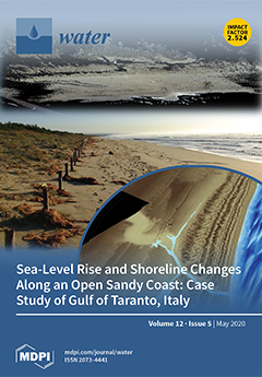
Cover Story (view full-size image): A sequence of geological events has led to the present position of the global sea-level and the related configuration of the coasts. However, ongoing climate change is producing rapid modifications in the environment with drastic consequences on the coastal areas. Such consequences are connected to sea-level rise, impact extreme marine events, and uncontrolled anthropogenic activities that together could produce significant coastal changes in the future. Precisely for these reasons, the development of new technologies is becoming useful for multidisciplinary studies and surveys of coastal environments, aimed at its management as the coasts represent one of the greatest residential and economic nodes on a global scale. View this paper.
  • Issues are regarded as officially published after their release is announced to the table of contents alert mailing list.
  • You may sign up for e-mail alerts to receive table of contents of newly released issues.
  • PDF is the official format for papers published in both, html and pdf forms. To view the papers in pdf format, click on the "PDF Full-text" link, and use the free Adobe Reader to open them.
Order results
Result details
Section
Select all
Export citation of selected articles as:
22 pages, 10667 KiB  
Article
Alternatives for Recovering the Ecosystem Services and Resilience of the Salamanca Island Natural Park, Colombia
by German Rivillas-Ospina, Mauro Antonio Maza-Chamorro, Sebastián Restrepo, Debora Lithgow, Rodolfo Silva, Augusto Sisa, Andrés Vargas, Juan Pablo Sarmiento, Juan Caes, Marianella Bolivar, Roberto Del Rio, Erick Campo, Diego Casas and Dennis Rudas
Water 2020, 12(5), 1513; https://doi.org/10.3390/w12051513 - 25 May 2020
Cited by 10 | Viewed by 8440
Abstract
From a comprehensive diagnosis of the associated basins, islands, and wetlands of the coastal lagoon system of Ciénaga Grande de Santa Marta, Colombia, this work describes feasible options for the recovery of its ecosystem’s health and ecological resilience. Firstly, the state of the [...] Read more.
From a comprehensive diagnosis of the associated basins, islands, and wetlands of the coastal lagoon system of Ciénaga Grande de Santa Marta, Colombia, this work describes feasible options for the recovery of its ecosystem’s health and ecological resilience. Firstly, the state of the coastal lagoon was assessed, finding that hydrology, wave climate, and the morphological changes of the coastline explain recent changes in the coastal wetlands. Key variables were used to describe the level of conservation or degradation of the coastal lagoon system and to identify measures to improve its ecological functions. Finally, to mimic some of these functions and improve connectivity of the ecosystems, green infrastructure alternatives were proposed for the short and medium term to recover the services of these ecosystems and restore their resilience. Full article
(This article belongs to the Special Issue Nature-Based Solutions for Coastal Engineering and Management)
Show Figures

Figure 1

18 pages, 3531 KiB  
Article
Assessment of Water Buffer Capacity of Two Morphometrically Different, Degraded, Urban Lakes
by Jolanta Grochowska
Water 2020, 12(5), 1512; https://doi.org/10.3390/w12051512 - 25 May 2020
Cited by 14 | Viewed by 8088
Abstract
The research was conducted in Karczemne Lake (area, 40.4 ha; maximum (max.) depth, 3.2 m) and Klasztorne Małe Lake (area, 13.7 ha; max. depth, 20.0 m) located in the Kashubian Lake District (Northern Poland). From the beginning of the 1950s, these reservoirs have [...] Read more.
The research was conducted in Karczemne Lake (area, 40.4 ha; maximum (max.) depth, 3.2 m) and Klasztorne Małe Lake (area, 13.7 ha; max. depth, 20.0 m) located in the Kashubian Lake District (Northern Poland). From the beginning of the 1950s, these reservoirs have received municipal and storm wastewater. The long-term process of lake contamination has shaped the specific buffer capacity conditions and influenced the circulation of carbonate and bicarbonate in the water of these ecosystems. Extremely high concentrations of nutrients (Karczemne Lake: max. total phosphorous (TP) level, 7.5 mg P L−1; max. total nitrogen (TN) level, 5.6 mg N L−1; Klasztorne Małe Lake: max. TP level, 20.6 mg P L−1; max. TN level, 43.3 mg N L−1) have caused very intensive primary production processes (Karczemne Lake: max. chlorophyll-a level, 193.40 µg m−3; max. Secchi disc visibility, 0.85 m; Klasztorne Małe Lake: max. chlorophyll-a level, 160.01 µg m−3; max. Secchi disc visibility, 1.15 m). In the polymictic Karczemne Lake, the pH value of all water columns exceeded 10.0 (max. pH, 10.41), and in the meromictic Klasztorne Małe Lake, the pH of the surface water layers oscillated around 9.5. In the polymictic Karczemne Lake, despite intensive photosynthesis, the calcium content and alkalinity were similar throughout the whole water column due to constant circulation. In the meromictic Klasztorne Małe Lake, during the growing season, a decrease in calcium concentration and alkalinity of the surface water layers and an increase in calcium concentration at the bottom were noted. Full article
(This article belongs to the Special Issue Environmental Chemistry of Water Quality Monitoring)
Show Figures

Figure 1

14 pages, 10631 KiB  
Communication
Experimental Investigation of Erosion Characteristics of Fine-Grained Cohesive Sediments
by Bommanna Gounder Krishnappan, Mike Stone, Steven J. Granger, Hari Ram Upadhayay, Qiang Tang, Yusheng Zhang and Adrian L. Collins
Water 2020, 12(5), 1511; https://doi.org/10.3390/w12051511 - 25 May 2020
Cited by 7 | Viewed by 3262
Abstract
In this short communication, the erosion process of the fine, cohesive sediment collected from the upper River Taw in South West England was studied in a rotating annular flume located in the National Water Research Institute in Burlington, Ontario, Canada. This study is [...] Read more.
In this short communication, the erosion process of the fine, cohesive sediment collected from the upper River Taw in South West England was studied in a rotating annular flume located in the National Water Research Institute in Burlington, Ontario, Canada. This study is part of a research project that is underway to model the transport of fine sediment and the associated nutrients in that river system. The erosion experimental data show that the critical shear stress for erosion of the upper River Taw sediment is about 0.09 Pa and it did not depend on the age of sediment deposit. The eroded sediment was transported in a flocculated form and the agent of flocculation for the upper River Taw sediment may be due to the presence of fibrils from microorganisms and organic material in the system. The experimental data were analysed using a curve fitting approach of Krone and a mathematical model of cohesive sediment transport in rotating circular flumes developed by Krishnappan. The modelled and measured data were in good agreement. An evaluation of the physical significance of Krone’s fitting coefficients is presented. Variability of the fitting coefficients as a function of bed shear stress and age of sediment deposit indicate the key role these two factors play in the erosion process of fluvial cohesive sediment. Full article
(This article belongs to the Special Issue Environmental Hydraulics Research)
Show Figures

Figure 1

18 pages, 852 KiB  
Perspective
Why Technologies Often Fail to Scale: Policy and Market Failures behind Limited Scaling of Alternate Wetting and Drying in Rice in Bangladesh
by Sushil Pandey, Sudhir Yadav, Jon Hellin, Jean Balié, Humnath Bhandari, Arvind Kumar and Manoranjan K. Mondal
Water 2020, 12(5), 1510; https://doi.org/10.3390/w12051510 - 25 May 2020
Cited by 17 | Viewed by 6660
Abstract
Rapid expansion of groundwater use for irrigation for dry season rice production in Bangladesh has led to overuse, deterioration of groundwater quality, increased cost of irrigation, and higher greenhouse gas emissions. The divergence between marginal private and social cost of irrigation due to [...] Read more.
Rapid expansion of groundwater use for irrigation for dry season rice production in Bangladesh has led to overuse, deterioration of groundwater quality, increased cost of irrigation, and higher greenhouse gas emissions. The divergence between marginal private and social cost of irrigation due to market failures in the presence of these externalities, has resulted in excessive use of groundwater. A combination of policy reforms and improvements in irrigation practices are hence needed to reduce irrigation water use. The paper analyses why an improved irrigation practice, known as “alternate wetting and drying (AWD)” that can potentially reduce irrigation water use substantially, has failed to scale despite widespread testing and promotion in Bangladesh for over a decade. The main reason for this failure to scale is the lack of economic incentives to save water as pricing is based on per unit area irrigated, not on the amount of water used. This paper highlights the dynamics of the water market and pricing in Bangladesh, along with biophysical and social constraints to farmer adoption of AWD. It also proposes changes in policy incentives, new directions for crop and water management research, and institutional reforms for wider adoption of AWD and other water-saving practices. Full article
(This article belongs to the Section Water Use and Scarcity)
Show Figures

Figure 1

20 pages, 6191 KiB  
Article
Storm Surges in the Bohai Sea: The Role of Waves and Tides
by Yuanyi Li, Huan Feng, Guillaume Vigouroux, Dekui Yuan, Guangyu Zhang, Xiaodi Ma and Kun Lei
Water 2020, 12(5), 1509; https://doi.org/10.3390/w12051509 - 25 May 2020
Cited by 2 | Viewed by 4081
Abstract
A storm surge is a complex phenomenon in which waves, tide and current interact. Even though wind is the predominant force driving the surge, waves and tidal phase are also important factors that influence the mass and momentum transport during the surge. Devastating [...] Read more.
A storm surge is a complex phenomenon in which waves, tide and current interact. Even though wind is the predominant force driving the surge, waves and tidal phase are also important factors that influence the mass and momentum transport during the surge. Devastating storm surges often occur in the Bohai Sea, a semi-enclosed shallow sea in North China, due to extreme storms. However, the effects of waves on storm surges in the Bohai Sea have not been quantified and the mechanisms responsible for the higher surges that affect part of the Bohai Sea have not been thoroughly studied. In this study, we set up a storm surge model, considering coupled effects of tides and waves on the surges. Validation against measured data shows that the coupled model is capable of simulating storm surges in the Bohai Sea. The simulation results indicate that the longshore currents, which are induced by the large gradient of radiation stress due to wave deformation, are one of the main contributors to the higher surges occurring in some coastal regions. The gently varying bathymetry is another factor contributing to these surges. With such bathymetry, the wave force direction is nearly uniform, and pushes a large amount of water in that direction. Under these conditions, the water accumulates in some parts of the coast, leading to higher surges in nearby coastal regions such as the south coast of the Bohai Bay and the west and south coasts of the Laizhou Bay. Results analysis also shows that the tidal phase at which the surge occurs influences the wave–current interactions, and these interactions are more evident in shallow waters. Neglecting these interactions can lead to inaccurate predictions of the storm surges due to overestimation or underestimation of wave-induced set-up. Full article
(This article belongs to the Section Hydraulics and Hydrodynamics)
Show Figures

Figure 1

17 pages, 4252 KiB  
Article
Utility of Artificial Neural Networks in Modeling Pan Evaporation in Hyper-Arid Climates
by Abdullah A. Alsumaiei
Water 2020, 12(5), 1508; https://doi.org/10.3390/w12051508 - 25 May 2020
Cited by 29 | Viewed by 4503
Abstract
Evaporation is the major water-loss component of the hydrologic cycle and thus requires efficient management. This study aims to model daily pan evaporation rates in hyper-arid climates using artificial neural networks (ANNs). Hyper-arid climates are characterized by harsh environmental conditions where annual precipitation [...] Read more.
Evaporation is the major water-loss component of the hydrologic cycle and thus requires efficient management. This study aims to model daily pan evaporation rates in hyper-arid climates using artificial neural networks (ANNs). Hyper-arid climates are characterized by harsh environmental conditions where annual precipitation rates do not exceed 3% of annual evaporation rates. For the first time, ANNs were applied to model such climatic conditions in the State of Kuwait. Pan evaporation data from 1993–2015 were normalized to a 0–1 range to boost ANN performance and the ANN structure was optimized by testing various meteorological input combinations. Levenberg–Marquardt algorithms were used to train the ANN models. The proposed ANN was satisfactorily efficient in modeling pan evaporation in these hyper-arid climatic conditions. The Nash–Sutcliffe coefficients ranged from 0.405 to 0.755 over the validation period. Mean air temperatures and average wind speeds were identified as meteorological variables that most influenced the ANN performance. A sensitivity analysis showed that the number of hidden layers did not significantly impact the ANN performance. The ANN models demonstrated considerable bias in predicting high pan evaporation rates (>25 mm/day). The proposed modeling method may assist water managers in Kuwait and other hyper-arid regions in establishing resilient water-management plans. Full article
(This article belongs to the Special Issue The Application of Artificial Intelligence in Hydrology)
Show Figures

Figure 1

4 pages, 163 KiB  
Editorial
Water Treatment with New Nanomaterials
by Shahin Homaeigohar
Water 2020, 12(5), 1507; https://doi.org/10.3390/w12051507 - 25 May 2020
Cited by 15 | Viewed by 3538
Abstract
The studies introduced in this special issue aim to provide a state-of-the-art vision for nanomaterials-based technology that could profit the water treatment industry. Given the expanding crisis of water shortages across the world, this perspective is invaluable and of paramount importance. No doubt, [...] Read more.
The studies introduced in this special issue aim to provide a state-of-the-art vision for nanomaterials-based technology that could profit the water treatment industry. Given the expanding crisis of water shortages across the world, this perspective is invaluable and of paramount importance. No doubt, as the environmental challenges are going to be more complicated and to extend to as-yet unconsidered areas, we need to upgrade our facilities and knowledge to address them properly. Nanomaterials are indeed promising building blocks for such advanced technologies that enable them to purify water streams from complex pollutants in an energy, cost and time-effective manner. The focus of the (review and original research) articles collected in this issue is on various kinds of nanomaterials made of carbon, polymer, metal, and metal oxides (magnetic and photocatalyst), that are employed for adsorption and photodegradation of heavy metals and organic pollutants, respectively. Here, I briefly review the insights given in these precious studies and suggest new directions for future research in this field. Full article
(This article belongs to the Special Issue Water Treatment with New Nanomaterials)
16 pages, 3171 KiB  
Article
Towards a Predictive Model for Initial Chlorine Dose in Humanitarian Emergencies
by Hongjian Wu and Caetano C. Dorea
Water 2020, 12(5), 1506; https://doi.org/10.3390/w12051506 - 25 May 2020
Cited by 6 | Viewed by 4088
Abstract
Free chlorination is a widely employed disinfection method in humanitarian water provision due to its many advantages. However, its effective application is hindered by the challenge in determining adequate initial doses to achieve free chlorine residuals that satisfy both health and aesthetic requirements. [...] Read more.
Free chlorination is a widely employed disinfection method in humanitarian water provision due to its many advantages. However, its effective application is hindered by the challenge in determining adequate initial doses to achieve free chlorine residuals that satisfy both health and aesthetic requirements. Current guidelines show varying recommended dosing strategies, and many do not adequately consider chlorine decay mechanisms that occur during water storage. Even though turbidity is commonly used as a criterion for deciding chlorine dose, it may not be an adequate proxy for the water quality in many cases. This paper addresses the fundamental relationships between chlorine decay kinetics and selected key water parameters (i.e., natural organic matter, water temperature, chlorine demand) by conducting chlorine decay tests in controlled conditions and in jerrycans (i.e., simulating humanitarian water treatment conditions). Chlorine decay constant from the Feben and Taras’s empirical model and first order model formed linear and exponential relationships with two water parameters (UVA254 and 30-min chlorine demand). With these relationships, the two chlorine decay models can be calibrated quickly and frequently in the field, allowing effective determination of initial chlorine dose. These two models calibrated based on the suggested water parameters from the study could predict chlorine decay in water having a main chlorine demand-inducing constituents as natural organic matter. However, they underpredicted chlorine decay in surface water with additional chlorine reactants. Further research on additional chlorine decay mechanisms is needed to expand the applicability of the models. Full article
(This article belongs to the Special Issue Point-of-Use Water Treatment)
Show Figures

Figure 1

25 pages, 1387 KiB  
Review
Organic Fouling in Forward Osmosis: A Comprehensive Review
by Sudesh Yadav, Ibrar Ibrar, Salam Bakly, Daoud Khanafer, Ali Altaee, V. C. Padmanaban, Akshaya Kumar Samal and Alaa H. Hawari
Water 2020, 12(5), 1505; https://doi.org/10.3390/w12051505 - 25 May 2020
Cited by 49 | Viewed by 6937
Abstract
Organic fouling in the forward osmosis process is complex and influenced by different parameters in the forward osmosis such as type of feed and draw solution, operating conditions, and type of membrane. In this article, we reviewed organic fouling in the forward osmosis [...] Read more.
Organic fouling in the forward osmosis process is complex and influenced by different parameters in the forward osmosis such as type of feed and draw solution, operating conditions, and type of membrane. In this article, we reviewed organic fouling in the forward osmosis by focusing on wastewater treatment applications. Model organic foulants used in the forward osmosis literature were highlighted, which were followed by the characteristics of organic foulants when real wastewater was used as feed solution. The various physical and chemical cleaning protocols for the organic fouled membrane are also discussed. The study also highlighted the effective pre-treatment strategies that are effective in reducing the impact of organic fouling on the forward osmosis (FO) membrane. The efficiency of cleaning methods for the removal of organic fouling in the FO process was investigated, including recommendations on future cleaning technologies such as Ultraviolet and Ultrasound. Generally, a combination of physical and chemical cleaning is the best for restoring the water flux in the FO process. Full article
(This article belongs to the Special Issue Novel Forward Osmotic Process for Seawater and Wastewater Treatment)
Show Figures

Graphical abstract

17 pages, 3679 KiB  
Article
Integration of Microwave and Optical/Infrared Derived Datasets from Multi-Satellite Products for Drought Monitoring
by Zhengdong Wang, Peng Guo, Hong Wan, Fuyou Tian and Linjiang Wang
Water 2020, 12(5), 1504; https://doi.org/10.3390/w12051504 - 25 May 2020
Cited by 8 | Viewed by 3610
Abstract
Drought is among the most common natural disasters in North China. In order to monitor the drought of the typically arid areas in North China, this study proposes an innovative multi-source remote sensing drought index called the improved Temperature–Vegetation–Soil Moisture Dryness Index (iTVMDI), [...] Read more.
Drought is among the most common natural disasters in North China. In order to monitor the drought of the typically arid areas in North China, this study proposes an innovative multi-source remote sensing drought index called the improved Temperature–Vegetation–Soil Moisture Dryness Index (iTVMDI), which is based on passive microwave remote sensing data from the FengYun (FY)3B-Microwave Radiation Imager (MWRI) and optical and infrared data from the Moderate Resolution Imaging Spectroradiometer (MODIS), and takes the Shandong Province of China as the research area. The iTVMDI integrated the advantages of microwave and optical remote sensing data to improve the original Temperature–Vegetation–Soil Moisture Dryness Index (TVMDI) model, and was constructed based on the Modified Soil-Adjusted Vegetation Index (MSAVI), land surface temperature (LST), and downscaled soil moisture (SM) as the three-dimensional axes. The global land data assimilation system (GLDAS) SM, meteorological data and surface water were used to evaluate and verify the monitoring results. The results showed that iTVMDI had a higher negative correlation with GLDAS SM (R = −0.73) than TVMDI (R = −0.55). Additionally, the iTVMDI was well correlated with both precipitation and surface water, with mean correlation coefficients (R) of 0.65 and 0.81, respectively. Overall, the accuracy of drought estimation can be significantly improved by using multi-source satellite data to measure the required surface variables, and the iTVMDI is an effective method for monitoring the spatial and temporal variations of drought. Full article
Show Figures

Figure 1

20 pages, 4768 KiB  
Case Report
Optimized Pumping Strategy for Reducing the Spatial Extent of Saltwater Intrusion along the Coast of Wadi Ham, UAE
by Modou A. Sowe, Sadhasivam Sathish, Nicolas Greggio and Mohamed M. Mohamed
Water 2020, 12(5), 1503; https://doi.org/10.3390/w12051503 - 24 May 2020
Cited by 7 | Viewed by 3776
Abstract
Many coastal aquifers are facing severe anthropogenic impacts such as urbanization, industrialization and agricultural activities are resulting in a saltwater intrusion. This establishes the need for a sustainable groundwater management strategy aimed to overcome the situation. Pumping of brackish/saline water to mitigate saltwater [...] Read more.
Many coastal aquifers are facing severe anthropogenic impacts such as urbanization, industrialization and agricultural activities are resulting in a saltwater intrusion. This establishes the need for a sustainable groundwater management strategy aimed to overcome the situation. Pumping of brackish/saline water to mitigate saltwater intrusion is a major potential approach to effectively control saltwater intrusion. However, this method has many challenges including selection of appropriate discharge rates under an optimum number of pumping wells and at specified wells distance from the shoreline. Hence, this study developed a Finite Element Flow and solute transport model (FEFLOW) to simulate three scenarios to assess the most appropriate pumping rates, number of wells and optimum well locations from the shoreline. These parameters were assessed and evaluated with respect to the change in groundwater saline concentration at different distance from the coastline. The 15,000 mg L−1 isosalinity contour line was used as a linear threshold to assess the progression of saltwater intrusion along three major locations in the aquifer. Scenario One was simulated with a constant number of wells and rate of pumping. Shifting of pumping wells to several distances from the shoreline was conducted. Scenario Two assessed the most appropriate number of pumping wells under constant pumping rates and distances from the shoreline and in scenario 3, the optimum pumping rates under a constant number of wells and distance from the shoreline were simulated. The results showed that the pumping of brackish/saline water from a distance of 1500 m from the shoreline using 16 pumping wells at a total pumping rate of 8000 m3 d−1 is the most effective solution in contrasting the saltwater intrusion in the Wadi Ham coastal aquifer. Full article
(This article belongs to the Special Issue Advances in Groundwater and Surface Water Monitoring and Management)
Show Figures

Figure 1

22 pages, 7920 KiB  
Article
Glacier Changes and Their Linkage to the Climate-Topographic Context in the Borohoro Mountains, Tian Shan 1977–2018
by Yanan Li
Water 2020, 12(5), 1502; https://doi.org/10.3390/w12051502 - 24 May 2020
Cited by 8 | Viewed by 3679
Abstract
Against the backdrop of climate change and socio-ecological sustainability, studying glacier changes provides essential knowledge to the basic water needs and security for regions and populations under such threats, such as Central Asia. Little attention has focused on glaciers in the northern periphery [...] Read more.
Against the backdrop of climate change and socio-ecological sustainability, studying glacier changes provides essential knowledge to the basic water needs and security for regions and populations under such threats, such as Central Asia. Little attention has focused on glaciers in the northern periphery of the Chinese Tian Shan. This study aims to map a recent glacier inventory and examine the glacier area shrinkage and surface elevation change for the central massif of the Borohoro Mountains in the past 41 years. Using declassified Hexagon images (1977), Landsat 5 TM (1994 and 2007), Sentinel 2A (2018) and altimetry data from the Ice, Cloud and Land Elevation Satellite (ICESat) over 2003–2009 with the 30-m Shuttle Radar Topography Mission (SRTM) digital elevation model, multi-temporal glacier fluctuations and the influence of topographic and climatic factors were investigated. Results show that the glacier area decreased from 287.5 ± 8.2 km2 in 1977 to 215.8 ± 4.1 km2 in 2018, at a rate of 0.61 ± 0.01% year−1. Glacier disintegration has led to a gradual increase in the number of glaciers and reached 224 glaciers in 2018. The shrinkage was at the highest rate during the 1994–2007 period and the smallest during 1977–1994. Glacier size, hypsometry, and median, maximum, and range of elevation are the most significantly correlated parameters with the relative area change. The surface elevation changes from two of the largest glaciers revealed a stronger thinning on the southern slope compared to the northern slope. These observations of glacier loss are primarily driven by the marked warming trend since the 1970s and confirmed with the overall pattern of glacier retreat in the Tian Shan from previous studies. Full article
(This article belongs to the Section Hydrology)
Show Figures

Figure 1

30 pages, 5817 KiB  
Article
Springs and Springs-Dependent Taxa of the Colorado River Basin, Southwestern North America: Geography, Ecology and Human Impacts
by Lawrence E. Stevens, Jeffrey Jenness and Jeri D. Ledbetter
Water 2020, 12(5), 1501; https://doi.org/10.3390/w12051501 - 24 May 2020
Cited by 12 | Viewed by 6882
Abstract
The Colorado River basin (CRB), the primary water source for southwestern North America, is divided into the 283,384 km2, water-exporting Upper CRB (UCRB) in the Colorado Plateau geologic province, and the 344,440 km2, water-receiving Lower CRB (LCRB) in the [...] Read more.
The Colorado River basin (CRB), the primary water source for southwestern North America, is divided into the 283,384 km2, water-exporting Upper CRB (UCRB) in the Colorado Plateau geologic province, and the 344,440 km2, water-receiving Lower CRB (LCRB) in the Basin and Range geologic province. Long-regarded as a snowmelt-fed river system, approximately half of the river’s baseflow is derived from groundwater, much of it through springs. CRB springs are important for biota, culture, and the economy, but are highly threatened by a wide array of anthropogenic factors. We used existing literature, available databases, and field data to synthesize information on the distribution, ecohydrology, biodiversity, status, and potential socio-economic impacts of 20,872 reported CRB springs in relation to permanent stream distribution, human population growth, and climate change. CRB springs are patchily distributed, with highest density in montane and cliff-dominated landscapes. Mapping data quality is highly variable and many springs remain undocumented. Most CRB springs-influenced habitats are small, with a highly variable mean area of 2200 m2, generating an estimated total springs habitat area of 45.4 km2 (0.007% of the total CRB land area). Median discharge also is generally low and variable (0.10 L/s, N = 1687, 95% CI = 0.04 L/s), but ranges up to 1800 L/s. Water pH and conductivity is negatively related to elevation, with a stronger negative relationship in the UCRB compared to the LCRB. Natural springs water temperature and geochemistry throughout the CRB varies greatly among springs, but relatively little within springs, and depends on aquifer hydrogeology, elevation, and residence time. As the only state nearly entirely included within the CRB, Arizona is about equally divided between the two geologic provinces. Arizona springs produce approximately 0.6 km3/year of water. Data on >330 CRB springs-dependent taxa (SDT) revealed at least 62 plant species; 216 aquatic and riparian Mollusca, Hemiptera, Coleoptera, and other invertebrate taxa; several herpetofanual species; and two-thirds of 35 CRB fish taxa. Springs vegetation structure, composition, and diversity vary strongly by springs type, and plant species density within springs is high in comparison with upland habitats. Plant species richness and density is negatively related to elevation below 2500 m. Human population in and adjacent to the CRB are growing rapidly, and ecological impairment of springs exceeds 70% in many landscapes, particularly in urbanized and rangeland areas. Anthropogenic stressors are primarily related to groundwater depletion and pollution, livestock management, flow abstraction, non-native species introduction, and recreation. Ensuring the ecological integrity and sustainability of CRB groundwater supplies and springs will require more thorough basic inventory, assessment, research, information management, and local ecosystem rehabilitation, as well as improved groundwater and springs conservation policy. Full article
Show Figures

Figure 1

18 pages, 4086 KiB  
Article
Comparative Analysis of Recurrent Neural Network Architectures for Reservoir Inflow Forecasting
by Halit Apaydin, Hajar Feizi, Mohammad Taghi Sattari, Muslume Sevba Colak, Shahaboddin Shamshirband and Kwok-Wing Chau
Water 2020, 12(5), 1500; https://doi.org/10.3390/w12051500 - 24 May 2020
Cited by 192 | Viewed by 10941
Abstract
Due to the stochastic nature and complexity of flow, as well as the existence of hydrological uncertainties, predicting streamflow in dam reservoirs, especially in semi-arid and arid areas, is essential for the optimal and timely use of surface water resources. In this research, [...] Read more.
Due to the stochastic nature and complexity of flow, as well as the existence of hydrological uncertainties, predicting streamflow in dam reservoirs, especially in semi-arid and arid areas, is essential for the optimal and timely use of surface water resources. In this research, daily streamflow to the Ermenek hydroelectric dam reservoir located in Turkey is simulated using deep recurrent neural network (RNN) architectures, including bidirectional long short-term memory (Bi-LSTM), gated recurrent unit (GRU), long short-term memory (LSTM), and simple recurrent neural networks (simple RNN). For this purpose, daily observational flow data are used during the period 2012–2018, and all models are coded in Python software programming language. Only delays of streamflow time series are used as the input of models. Then, based on the correlation coefficient (CC), mean absolute error (MAE), root mean square error (RMSE), and Nash–Sutcliffe efficiency coefficient (NS), results of deep-learning architectures are compared with one another and with an artificial neural network (ANN) with two hidden layers. Results indicate that the accuracy of deep-learning RNN methods are better and more accurate than ANN. Among methods used in deep learning, the LSTM method has the best accuracy, namely, the simulated streamflow to the dam reservoir with 90% accuracy in the training stage and 87% accuracy in the testing stage. However, the accuracies of ANN in training and testing stages are 86% and 85%, respectively. Considering that the Ermenek Dam is used for hydroelectric purposes and energy production, modeling inflow in the most realistic way may lead to an increase in energy production and income by optimizing water management. Hence, multi-percentage improvements can be extremely useful. According to results, deep-learning methods of RNNs can be used for estimating streamflow to the Ermenek Dam reservoir due to their accuracy. Full article
(This article belongs to the Section Hydrology)
Show Figures

Figure 1

23 pages, 6120 KiB  
Article
Do Land Use Changes Balance out Sediment Yields under Climate Change Predictions on the Sub-Basin Scale? The Carpathian Basin as an Example
by Paulina Orlińska-Woźniak, Ewa Szalińska and Paweł Wilk
Water 2020, 12(5), 1499; https://doi.org/10.3390/w12051499 - 23 May 2020
Cited by 12 | Viewed by 3744
Abstract
The issue of whether land use changes will balance out sediment yields induced by climate predictions was assessed for a Carpathian basin (Raba River, Poland). This discussion was based on the Macromodel DNS (Discharge–Nutrient–Sea)/SWAT (Soil and Water Assessment Tool) results for the RCP [...] Read more.
The issue of whether land use changes will balance out sediment yields induced by climate predictions was assessed for a Carpathian basin (Raba River, Poland). This discussion was based on the Macromodel DNS (Discharge–Nutrient–Sea)/SWAT (Soil and Water Assessment Tool) results for the RCP 4.5 and RCP 8.5 scenarios and LU predictions. To track sediment yield responses on the sub-basin level the studied area was divided into 36 units. The response of individual sub-basins to climate scenarios created a mosaic of negative and positive sediment yield changes in comparison to the baseline scenario. Then, overlapped forest and agricultural areas change indicated those sub-basins where sediment yields could be balanced out or not. The model revealed that sediment yields could be altered even by 49% in the selected upper sub-basins during the spring-summer months, while for the lower sub-basins the predicted changes will be less effective (3% on average). Moreover, the winter period, which needs to be re-defined due to an exceptional occurrence of frost and snow cover protecting soils against erosion, will significantly alter the soil particle transfer among the seasons. Finally, it has been shown that modeling of sediment transport, based on averaged meteorological values and LU changes, can lead to significant errors. Full article
Show Figures

Graphical abstract

18 pages, 14677 KiB  
Article
Spatiotemporal Water Yield Variations and Influencing Factors in the Lhasa River Basin, Tibetan Plateau
by Huiting Lu, Yan Yan, Jieyuan Zhu, Tiantian Jin, Guohua Liu, Gang Wu, Lindsay C. Stringer and Martin Dallimer
Water 2020, 12(5), 1498; https://doi.org/10.3390/w12051498 - 23 May 2020
Cited by 24 | Viewed by 4358
Abstract
Understanding the spatiotemporal characteristics of water yield and its influencing factors is important for water resources management. In this study, we used the seasonal water yield model (SWYM) to assess the spatiotemporal water yield changes of the Lhasa River Basin from 1990 to [...] Read more.
Understanding the spatiotemporal characteristics of water yield and its influencing factors is important for water resources management. In this study, we used the seasonal water yield model (SWYM) to assess the spatiotemporal water yield changes of the Lhasa River Basin from 1990 to 2015, and analyzed its influencing factors by focusing on precipitation, land cover, and normalized difference vegetation index (NDVI) change. We first examined the model through Morris screening sensitivity analysis and validated it with the observed flow data. Spatiotemporal variation of three indices of water yield, baseflow, quick flow, and local recharge were then assessed. Results showed that from 1990 to 2015, the baseflow, local recharge, and quick flow decreased by 67.03%, 80.21%, and 37.03%, respectively. The spatial pattern of water yield remained mostly unchanged. According to the contribution analysis, precipitation and NDVI change were the main factors affecting water yield in the Lhasa River Basin, while land cover change began to exert greater influence after 2010. A combination of climate change and human activities therefore drive water yield change, especially through vegetation change. Water resources management strategies should thus take into account the combination of rapidly changing climate and human activities. Full article
(This article belongs to the Section Hydrology)
Show Figures

Figure 1

25 pages, 10917 KiB  
Article
The First Video Witness of Coastal Boulder Displacements Recorded during the Impact of Medicane “Zorbas” on Southeastern Sicily
by Giovanni Scicchitano, Giovanni Scardino, Sebastiano Tarascio, Carmelo Monaco, Giovanni Barracane, Giuseppe Locuratolo, Maurilio Milella, Arcangelo Piscitelli, Gianfranco Mazza and Giuseppe Mastronuzzi
Water 2020, 12(5), 1497; https://doi.org/10.3390/w12051497 - 23 May 2020
Cited by 24 | Viewed by 3748
Abstract
Over the last few years, several authors have presented contrasting models to describe the response of boulders to extreme waves, but the absence of direct observation of movements has hindered the evaluation of these models. The recent development of online video-sharing platforms in [...] Read more.
Over the last few years, several authors have presented contrasting models to describe the response of boulders to extreme waves, but the absence of direct observation of movements has hindered the evaluation of these models. The recent development of online video-sharing platforms in coastal settings has provided the opportunity to monitor the evolution of rocky coastlines during storm events. In September 2018, a surveillance camera of the Marine Protected Area of Plemmirio recorded the movement of several boulders along the coast of Maddalena Peninsula (Siracusa, Southeastern Sicily) during the landfall of the Mediterranean tropical-like cyclone (Medicane) Zorbas. Unmanned autonomous vehicle (UAV) photogrammetric and terrestrial laser scanner (TLS) surveys were performed to reconstruct immersive virtual scenarios to geometrically analyze the boulder displacements recorded in the video. Analyses highlighted that the displacements occurred when the boulders were submerged as a result of the impact of multiple small waves rather than due to a single large wave. Comparison between flow velocities obtained by videos and calculated through relationships showed a strong overestimation of the models, suggesting that values of flow density and lift coefficient used in literature are underestimated. Full article
(This article belongs to the Special Issue Relative Sea-Level Changes and their Impact on Coastal Zones)
Show Figures

Figure 1

14 pages, 728 KiB  
Article
Uptake of Sulfate from Ambient Water by Freshwater Animals
by Michael B. Griffith, James M. Lazorchak and Herman Haring
Water 2020, 12(5), 1496; https://doi.org/10.3390/w12051496 - 23 May 2020
Cited by 4 | Viewed by 2921
Abstract
To better understand how the sulfate (SO42−) anion may contribute to the adverse effects associated with elevated ionic strength or salinity in freshwaters, we measured the uptake and efflux of SO42− in four freshwater species: the fathead minnow [...] Read more.
To better understand how the sulfate (SO42−) anion may contribute to the adverse effects associated with elevated ionic strength or salinity in freshwaters, we measured the uptake and efflux of SO42− in four freshwater species: the fathead minnow (Pimephales promelas, Teleostei: Cyprinidae), paper pondshell (Utterbackia imbecillis, Bivalvia: Unionidae), red swamp crayfish (Procambarus clarkii, Crustacea: Cambaridae), and two-lined mayfly (Hexagenia bilineata, Insecta: Ephemeridae). Using δ(34S/32S) stable isotope ratios and the concentrations of S and SO42−, we measured the SO42− influx rate (Jin), net flux (Jnet), and efflux rate (Jout) during a 24 h exposure period. For all four species, the means of Jin for SO42− were positive, and Jin was significantly greater than 0 at both target SO42− concentrations in the fish and mollusk and at the lower SO42− concentration in the crayfish. The means of Jout and Jnet were much more variable than those for Jin, but several species by target SO42− concentration combinations for Jout and Jnet, were negative, which suggests the net excretion of SO42− by the animals. The results of our experiments suggest a greater regulation of SO42− in freshwater animals than has been previously reported. Full article
(This article belongs to the Special Issue Applied Ecology Research for Water Quality Management)
Show Figures

Figure 1

36 pages, 5498 KiB  
Concept Paper
An Integrative Information Aqueduct to Close the Gaps between Satellite Observation of Water Cycle and Local Sustainable Management of Water Resources
by Zhongbo Su, Yijian Zeng, Nunzio Romano, Salvatore Manfreda, Félix Francés, Eyal Ben Dor, Brigitta Szabó, Giulia Vico, Paolo Nasta, Ruodan Zhuang, Nicolas Francos, János Mészáros, Silvano Fortunato Dal Sasso, Maoya Bassiouni, Lijie Zhang, Donald Tendayi Rwasoka, Bas Retsios, Lianyu Yu, Megan Leigh Blatchford and Chris Mannaerts
Water 2020, 12(5), 1495; https://doi.org/10.3390/w12051495 - 23 May 2020
Cited by 10 | Viewed by 7130
Abstract
The past decades have seen rapid advancements in space-based monitoring of essential water cycle variables, providing products related to precipitation, evapotranspiration, and soil moisture, often at tens of kilometer scales. Whilst these data effectively characterize water cycle variability at regional to global scales, [...] Read more.
The past decades have seen rapid advancements in space-based monitoring of essential water cycle variables, providing products related to precipitation, evapotranspiration, and soil moisture, often at tens of kilometer scales. Whilst these data effectively characterize water cycle variability at regional to global scales, they are less suitable for sustainable management of local water resources, which needs detailed information to represent the spatial heterogeneity of soil and vegetation. The following questions are critical to effectively exploit information from remotely sensed and in situ Earth observations (EOs): How to downscale the global water cycle products to the local scale using multiple sources and scales of EO data? How to explore and apply the downscaled information at the management level for a better understanding of soil-water-vegetation-energy processes? How can such fine-scale information be used to improve the management of soil and water resources? An integrative information flow (i.e., iAqueduct theoretical framework) is developed to close the gaps between satellite water cycle products and local information necessary for sustainable management of water resources. The integrated iAqueduct framework aims to address the abovementioned scientific questions by combining medium-resolution (10 m–1 km) Copernicus satellite data with high-resolution (cm) unmanned aerial system (UAS) data, in situ observations, analytical- and physical-based models, as well as big-data analytics with machine learning algorithms. This paper provides a general overview of the iAqueduct theoretical framework and introduces some preliminary results. Full article
Show Figures

Graphical abstract

29 pages, 4763 KiB  
Article
Evaluation of Radar-Gauge Merging Techniques to Be Used in Operational Flood Forecasting in Urban Watersheds
by Dayal Wijayarathne, Paulin Coulibaly, Sudesh Boodoo and David Sills
Water 2020, 12(5), 1494; https://doi.org/10.3390/w12051494 - 23 May 2020
Cited by 13 | Viewed by 4252
Abstract
Demand for radar Quantitative Precipitation Estimates (QPEs) as precipitation forcing to hydrological models in operational flood forecasting has increased in the recent past. It is practically impossible to get error-free QPEs due to the intrinsic limitations of weather radar as a precipitation measurement [...] Read more.
Demand for radar Quantitative Precipitation Estimates (QPEs) as precipitation forcing to hydrological models in operational flood forecasting has increased in the recent past. It is practically impossible to get error-free QPEs due to the intrinsic limitations of weather radar as a precipitation measurement tool. Adjusting radar QPEs with gauge observations by combining their advantages while minimizing their weaknesses increases the accuracy and reliability of radar QPEs. This study deploys several techniques to merge two dual-polarized King City radar (WKR) C-band and two KBUF Next-Generation Radar (NEXRAD) S-band operational radar QPEs with rain gauge data for the Humber River (semi-urban) and Don River (urban) watersheds in Ontario, Canada. The relative performances are assessed against an independent gauge network by comparing hourly rainfall events. The Cumulative Distribution Function Matching (CDFM) method performed best, followed by Kriging with Radar-based Error correction (KRE). Although both WKR and NEXRAD radar QPEs improved significantly, NEXRAD Level III Digital Precipitation Array (DPA) provided the best results. All methods performed better for low- to medium-intensity precipitation but deteriorated with the increasing rainfall intensities. All methods outperformed radar only QPEs for all events, but the agreement is best in the summer. Full article
Show Figures

Figure 1

12 pages, 4148 KiB  
Article
Study on the Performance Improvement of Axial Flow Pump’s Saddle Zone by Using a Double Inlet Nozzle
by Weidong Cao and Wei Li
Water 2020, 12(5), 1493; https://doi.org/10.3390/w12051493 - 23 May 2020
Cited by 11 | Viewed by 4013
Abstract
The operating range of axial flow pumps is often constrained by the onset of rotating stall. An improved method using a double inlet nozzle to stabilize the performance curve is presented in the current study; a single inlet nozzle and three kinds of [...] Read more.
The operating range of axial flow pumps is often constrained by the onset of rotating stall. An improved method using a double inlet nozzle to stabilize the performance curve is presented in the current study; a single inlet nozzle and three kinds of double inlet nozzle with different rib gap widths at the inlet of axial flow pump impeller were designed. Three dimensional (3D) incompressible flow fields were simulated, and the distributions of turbulence kinetic energy and velocity at different flow rates located at the inlet section, as well as the pressure and streamline in the impeller, were obtained at the same time. The single inlet nozzle scheme and a double inlet nozzle scheme were studied; the experimental and numerical performance results show that although the cross section is partly blocked in the double inlet nozzle, the head and efficiency do not decline at stable operation flow rate. On small flow rate condition, the double inlet nozzle scheme effectively stabilized the head-flow performance, whereby the block induced by the backflow before the impeller was markedly improved by using a double inlet nozzle. It has also been found that the rib gap width impacts the efficiency curve of the axial flow pump. Full article
(This article belongs to the Special Issue Application of Smart Technologies in Water Resources Management)
Show Figures

Figure 1

29 pages, 10243 KiB  
Review
Life Cycle of Oil and Gas Fields in the Mississippi River Delta: A Review
by John W. Day, H. C. Clark, Chandong Chang, Rachael Hunter and Charles R. Norman
Water 2020, 12(5), 1492; https://doi.org/10.3390/w12051492 - 23 May 2020
Cited by 35 | Viewed by 8877
Abstract
Oil and gas (O&G) activity has been pervasive in the Mississippi River Delta (MRD). Here we review the life cycle of O&G fields in the MRD focusing on the production history and resulting environmental impacts and show how cumulative impacts affect coastal ecosystems. [...] Read more.
Oil and gas (O&G) activity has been pervasive in the Mississippi River Delta (MRD). Here we review the life cycle of O&G fields in the MRD focusing on the production history and resulting environmental impacts and show how cumulative impacts affect coastal ecosystems. Individual fields can last 40–60 years and most wells are in the final stages of production. Production increased rapidly reaching a peak around 1970 and then declined. Produced water lagged O&G and was generally higher during declining O&G production, making up about 70% of total liquids. Much of the wetland loss in the delta is associated with O&G activities. These have contributed in three major ways to wetland loss including alteration of surface hydrology, induced subsidence due to fluids removal and fault activation, and toxic stress due to spilled oil and produced water. Changes in surface hydrology are related to canal dredging and spoil placement. As canal density increases, the density of natural channels decreases. Interconnected canal networks often lead to saltwater intrusion. Spoil banks block natural overland flow affecting exchange of water, sediments, chemicals, and organisms. Lower wetland productivity and reduced sediment input leads to enhanced surficial subsidence. Spoil banks are not permanent but subside and compact over time and many spoil banks no longer have subaerial expression. Fluid withdrawal from O&G formations leads to induced subsidence and fault activation. Formation pore pressure decreases, which lowers the lateral confining stress acting in the formation due to poroelastic coupling between pore pressure and stress. This promotes normal faulting in an extensional geological environment like the MRD, which causes surface subsidence in the vicinity of the faults. Induced reservoir compaction results in a reduction of reservoir thickness. Induced subsidence occurs in two phases especially when production rate is high. The first phase is compaction of the reservoir itself while the second phase is caused by a slow drainage of pore pressure in bounding shales that induces time-delayed subsidence associated with shale compaction. This second phase can continue for decades, even after most O&G has been produced, resulting in subsidence over much of an oil field that can be greater than surface subsidence due to altered hydrology. Produced water is water brought to the surface during O&G extraction and an estimated 2 million barrels per day were discharged into Louisiana coastal wetlands and waters from nearly 700 sites. This water is a mixture of either liquid or gaseous hydrocarbons, high salinity (up to 300 ppt) water, dissolved and suspended solids such as sand or silt, and injected fluids and additives associated with exploration and production activities and it is toxic to many estuarine organisms including vegetation and fauna. Spilled oil has lethal and sub-lethal effects on a wide range of estuarine organisms. The cumulative effect of alterations in surface hydrology, induced subsidence, and toxins interact such that overall impacts are enhanced. Restoration of coastal wetlands degraded by O&G activities should be informed by these impacts. Full article
Show Figures

Figure 1

32 pages, 23570 KiB  
Article
Automated Location Detection of Retention and Detention Basins for Water Management
by Sonja Teschemacher, Daniel Bittner and Markus Disse
Water 2020, 12(5), 1491; https://doi.org/10.3390/w12051491 - 23 May 2020
Cited by 7 | Viewed by 4041
Abstract
Retention and detention basins are engineering constructions with multiple objectives; e.g., flood protection and irrigation. Their performance is highly location-dependent, and thus, optimization strategies are needed. LOCASIN (Location detection of retention and detention basins) is an open-source MATLAB tool that enables automated and [...] Read more.
Retention and detention basins are engineering constructions with multiple objectives; e.g., flood protection and irrigation. Their performance is highly location-dependent, and thus, optimization strategies are needed. LOCASIN (Location detection of retention and detention basins) is an open-source MATLAB tool that enables automated and rapid detection, characterization and evaluation of basin locations. The site detection is based on a numerical raster analysis to determine the optimal dam axis orientation, the dam geometry and the basin area and volume. After selecting a reasonable basin combination, the results are summarized and visualized. LOCASIN represents a user-friendly and flexible tool for policy makers, engineers and scientists to determine dam and basin properties of optimized positions for planning and research purposes. It can be applied in an automated way to solve small and large scale engineering problems. The software is available on GitHub. Full article
Show Figures

Figure 1

4 pages, 162 KiB  
Editorial
Hydroclimatic Variability at Local, Regional and Global Scales
by Scott Curtis
Water 2020, 12(5), 1490; https://doi.org/10.3390/w12051490 - 23 May 2020
Cited by 2 | Viewed by 2247
Abstract
Hydroclimate is non-stationary and varies in often unpredictable ways on local, regional and global scales, which can lead to water insecurity. This editorial relates the advances and challenges in our understanding of the spatio-temporal relationship between climate variability and change and the components [...] Read more.
Hydroclimate is non-stationary and varies in often unpredictable ways on local, regional and global scales, which can lead to water insecurity. This editorial relates the advances and challenges in our understanding of the spatio-temporal relationship between climate variability and change and the components of the hydrologic cycle through the lens of six articles, which contributed to the Water Special Issue: Hydroclimatic Variability at Local, Regional and Global Scales. The relationship between the El Niño/Southern Oscillation and precipitation, temperature, and evapotranspiration is examined within the Indian Summer monsoon, gauge-based precipitation datasets are intercompared over Pakistan, trends in precipitation, temperature, and streamflow are investigated in Ethiopia and China, alternate configurations of hydroclimate modeling are assessed over Canada, and finally, future limitations in groundwater supply are presented for Italy. Full article
(This article belongs to the Special Issue Hydroclimatic Variability at Local, Regional, and Global Scales)
16 pages, 949 KiB  
Article
Comparing Internal Flow in Freezing and Evaporating Water Droplets Using PIV
by Linn Karlsson, Anna-Lena Ljung and T. Staffan Lundström
Water 2020, 12(5), 1489; https://doi.org/10.3390/w12051489 - 23 May 2020
Cited by 6 | Viewed by 2991
Abstract
The study of evaporation and freezing of droplets is important in, e.g., spray cooling, surface coating, ink-jet printing, and when dealing with icing on wind turbines, airplane wings, and roads. Due to the complex nature of the flow within droplets, a wide range [...] Read more.
The study of evaporation and freezing of droplets is important in, e.g., spray cooling, surface coating, ink-jet printing, and when dealing with icing on wind turbines, airplane wings, and roads. Due to the complex nature of the flow within droplets, a wide range of temperatures, from freezing temperatures to heating temperatures, have to be taken into account in order to increase the understanding of the flow behavior. This study aimed to reveal if natural convection and/or Marangoni convection influence the flow in freezing and evaporating droplets. Droplets were released on cold and warm surfaces using similar experimental techniques and setups, and the internal flow within freezing and evaporating water droplets were then investigated and compared to one another using Particle Image Velocimetry. It was shown that, for both freezing and evaporating droplets, a shift in flow direction occurs early in the processes. For the freezing droplets, this effect could be traced to the Marangoni convection, but this could not be concluded for the evaporating droplets. For both evaporating and freezing droplets, after the shift in flow direction, natural convection dominates the flow. In the end of the freezing process, conduction seems to be the only contributing factor for the flow. Full article
(This article belongs to the Special Issue Industrial and Environmental Fluid Mechanics)
Show Figures

Figure 1

16 pages, 6752 KiB  
Article
Experimental and Numerical Investigations of Turbulent Open Channel Flow over a Rough Scour Hole Downstream of a Groundsill
by Cheng-Kai Chang, Jau-Yau Lu, Shi-Yan Lu, Zhong-Xiang Wang and Dong-Sin Shih
Water 2020, 12(5), 1488; https://doi.org/10.3390/w12051488 - 22 May 2020
Cited by 4 | Viewed by 2708
Abstract
This study discusses the mechanism for the occurrence of equilibrium and non-equilibrium scour holes. By using a particle image velocimetry (PIV) measurement system, it measures the turbulent flow fields in an open channel moving through the rough bed below a groundsill. Then, the [...] Read more.
This study discusses the mechanism for the occurrence of equilibrium and non-equilibrium scour holes. By using a particle image velocimetry (PIV) measurement system, it measures the turbulent flow fields in an open channel moving through the rough bed below a groundsill. Then, the Reynolds-stress model (RSM), embedded in FLUENT software, is applied to perform a numerical simulation. The experimental results show that at equilibrium, the location of the re-attachment point is significantly affected by the flow discharge. Further, the re-attachment point of the scour hole affects the size and range of the counterflow zone, which becomes the main region for deposits in the natural channel. In addition, the formation of erosion is mainly affected by turbulence intensity and Reynolds stress. However, in non-equilibrium scour holes, our results clearly show that the turbulence intensity and the Reynolds stress are significantly larger at the end of the scour holes near the bed due to the continual development of the scouring. The correlation between the numerical simulation and experimental results are also examined. Overall, it can be seen that the simulated mean velocity profiles are quite consistent with the measured data. However, in terms of turbulence intensities and Reynolds stress, the simulated results could be overestimated when compared with the measured data; they are overestimated with a sudden decrease near the liquid surface. Although, the simulations in the near bed area show some divergence and the trend in the scour hole is quite consistent. Therefore, numerical simulations can be performed in advance to act as an important reference when evaluating the safety of downstream structures. Full article
(This article belongs to the Section Hydraulics and Hydrodynamics)
Show Figures

Figure 1

15 pages, 13317 KiB  
Article
Sentinel-2 Application to the Surface Characterization of Small Water Bodies in Wetlands
by Jesús Pena-Regueiro, Maria-Teresa Sebastiá-Frasquet, Javier Estornell and Jesús Antonio Aguilar-Maldonado
Water 2020, 12(5), 1487; https://doi.org/10.3390/w12051487 - 22 May 2020
Cited by 25 | Viewed by 5025
Abstract
Developing indicators to monitor environmental change in wetlands with the aid of Earth Observation Systems can help to obtain spatial data that is not feasible with in situ measures (e.g., flooding patterns). In this study, we aim to test Sentinel-2A/B images suitability for [...] Read more.
Developing indicators to monitor environmental change in wetlands with the aid of Earth Observation Systems can help to obtain spatial data that is not feasible with in situ measures (e.g., flooding patterns). In this study, we aim to test Sentinel-2A/B images suitability for detecting small water bodies in wetlands characterized by high diversity of temporal and spatial flooding patterns using previously published indices. For this purpose, we used medium spatial resolution Sentinel-2A/B images of four representative coastal wetlands in the Valencia Region (East Spain, Mediterranean Sea), and on three different dates. To validate the results, 60 points (30 in water areas and 30 in land areas) were distributed randomly within a 20 m buffer around the border of each digitized water polygon for each date and wetland (600 in total). These polygons were mapped using as a base map orthophotos of high spatial resolution. In our study, the best performing index was the NDWI. Overall accuracy and Kappa index results were optimal for −0.30 threshold in all the studied wetlands and dates. The consistency in the results is key to provide a methodology to characterize water bodies in wetlands as generalizable as possible. Most studies developed in wetlands have focused on calculating global gain or loss of wetland area. However, inside of wetlands which hold protection figures, the main threat is not necessarily land use change, but rather water management strategies. Applying Sentinel-2A/B images to calculate the NDWI index and monitor flooded area changes will be key to analyse the consequence of these management actions. Full article
(This article belongs to the Special Issue Advances in Groundwater and Surface Water Monitoring and Management)
Show Figures

Figure 1

10 pages, 9101 KiB  
Article
A New Method for Rapid Measurement of Canal Water Table Depth Using Airborne LiDAR, with Application to Drained Peatlands in Indonesia
by Ronald Vernimmen, Aljosja Hooijer, Dedi Mulyadi, Iwan Setiawan, Maarten Pronk and Angga T. Yuherdha
Water 2020, 12(5), 1486; https://doi.org/10.3390/w12051486 - 22 May 2020
Cited by 4 | Viewed by 3765
Abstract
Water management in lowland areas usually aims to keep water tables within a narrow range to avoid flooding and drought conditions. A common water management target parameter is the depth of the canal water table below the surrounding soil surface. We demonstrated a [...] Read more.
Water management in lowland areas usually aims to keep water tables within a narrow range to avoid flooding and drought conditions. A common water management target parameter is the depth of the canal water table below the surrounding soil surface. We demonstrated a method that rapidly determines canal water table depth (CWD) from airborne LiDAR data. The water table elevation was measured as the minimum value determined in a grid of 100 m × 100 m applied to a 1 m × 1 m digital terrain model (DTM), and the soil surface was calculated as the median value of values in each grid cell. Results for areas in eastern Sumatra and West Kalimantan, Indonesia, were validated against 145 field measurements at the time of LiDAR data collection. LiDAR-derived CWD was found to be accurate within 0.25 m and 0.5 m for 86% and 99% of field measurements, respectively, with an R2 value of 0.74. We demonstrated the method for CWD conditions in a drained peatland area in Central Kalimantan, where we found CWD in the dry season of 2011 to be generally below −1.5 and often below −2.5 m indicating severely overdrained conditions. We concluded that airborne LiDAR can provide an efficient and rapid mapping tool of CWD at the time of LiDAR data collection, which can be cost-effective especially where LiDAR data or derived DTMs are already available. The method can be applied to any LiDAR-based DTM that represents a flat landscape that has open water bodies. Full article
(This article belongs to the Section Hydrology)
Show Figures

Figure 1

23 pages, 1935 KiB  
Article
Can the Stream Quantification Tool (SQT) Protocol Predict the Biotic Condition of Streams in the Southeast Piedmont (USA)?
by Sara Donatich, Barbara Doll, Jonathan Page and Natalie Nelson
Water 2020, 12(5), 1485; https://doi.org/10.3390/w12051485 - 22 May 2020
Cited by 4 | Viewed by 4461
Abstract
In some states, the Stream Quantification Tool (SQT) has been adopted to quantify functional change of stream mitigation efforts. However, the ability of the SQT protocol to predict biological function and uphold the premise of the Stream Functions Pyramid (Pyramid) remains untested. Macroinvertebrate [...] Read more.
In some states, the Stream Quantification Tool (SQT) has been adopted to quantify functional change of stream mitigation efforts. However, the ability of the SQT protocol to predict biological function and uphold the premise of the Stream Functions Pyramid (Pyramid) remains untested. Macroinvertebrate community metrics in 34 headwater streams in Piedmont, North Carolina (NC, USA) were related to NC SQT protocol (version 3.0) factors and other variables relevant to ecological function. Three statistical models, including stepwise, lasso, and ridge regression were used to predict the NC Biotic Index (NCBI) and Ephemeroptera, Plecoptera, and Trichoptera (EPT) richness using two datasets: 21 SQT variables and the SQT variables plus 13 additional watershed, hydraulic, geomorphic, and physicochemical variables. Cross-validation revealed that stepwise and ridge outperformed lasso, and that the SQT variables can reasonably predict biology metrics (R2 0.53–0.64). Additional variables improved prediction (R2 0.70–0.88), suggesting that the SQT protocol is lacking metrics important to macroinvertebrates. Results moderately support the Pyramid: highly predictive ridge models included metrics from all levels, while highly predictive stepwise models included metrics from higher levels, and not watershed hydrology. Reach-scale metrics were more important than watershed hydrology, providing encouragement for projects limited by watershed condition. Full article
Show Figures

Figure 1

18 pages, 15261 KiB  
Article
Real Time Flow Forecasting in a Mountain River Catchment Using Conceptual Models with Simple Error Correction Scheme
by Nicolás Montes, José Ángel Aranda and Rafael García-Bartual
Water 2020, 12(5), 1484; https://doi.org/10.3390/w12051484 - 22 May 2020
Cited by 4 | Viewed by 2810
Abstract
Methods in operational hydrology for real-time flash-flood forecasting need to be simple enough to match requirements of real-time system management. For this reason, hydrologic routing methods are widely used in river engineering. Among them, the popular Muskingum method is the most extended one, [...] Read more.
Methods in operational hydrology for real-time flash-flood forecasting need to be simple enough to match requirements of real-time system management. For this reason, hydrologic routing methods are widely used in river engineering. Among them, the popular Muskingum method is the most extended one, due to its simplicity and parsimonious formulation involving only two parameters. In the present application, two simple conceptual models with an error correction scheme were used. They were applied in practice to a mountain catchment located in the central Pyrenees (North of Spain), where occasional flash flooding events take place. Several relevant historical flood events have been selected for calibration and validation purposes. The models were designed to produce real-time predictions at the downstream gauge station, with variable lead times during a flood event. They generated accurate estimates of forecasted discharges at the downstream end of the river reach. For the validation data set and 2 h lead time, the estimated Nash-Sutcliffe coefficient was 0.970 for both models tested. The quality of the results, together with the simplicity of the formulations proposed, suggests an interesting potential for the practical use of these schemes for operational hydrology purposes. Full article
(This article belongs to the Special Issue Nature-Based Approaches in River Engineering)
Show Figures

Figure 1

Previous Issue
Next Issue
Back to TopTop