Skip to Content

Remote Sensing, Volume 14, Issue 9

2022 May-1 - 335 articles

Cover Story: 
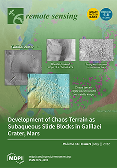
Blocky landscapes on Mars, known as ‘chaos terrain’, develop in topographic lows and through debated formation mechanisms. Several different hypotheses explain chaos terrain development, but no one hypothesis can explain all of the incidents of chaos terrain. In this study, we focus on the Galilaei crater, a paleolake with chaos terrain concentrated along the crater’s interior walls. Blocks that define the chaos terrain are associated with parts of the crater wall that are relatively less steep than others, and polygonal cracks on the crater floor reflect the evaporation of ancient standing water. We propose that the morphologies observed can be explained by subaqueous mass flow, analogous to submarine shelf slides on Earth. We discuss Earth analogs and the implications of these observations for Mars. View this paper
  • Issues are regarded as officially published after their release is announced to the table of contents alert mailing list .
  • You may sign up for email alerts to receive table of contents of newly released issues.
  • PDF is the official format for papers published in both, html and pdf forms. To view the papers in pdf format, click on the "PDF Full-text" link, and use the free Adobe Reader to open them.

Articles (335)

  • Article
  • Open Access
2,408 Views
20 Pages

9 May 2022

Vegetation isoline equations describe analytical relationships between two reflectances of different wavelengths. Their applications range from retrievals of biophysical parameters to the derivation of the inter-sensor relationships of spectral veget...

  • Article
  • Open Access
5 Citations
3,225 Views
20 Pages

9 May 2022

Data acquisition systems and methods to capture high-resolution images or reconstruct 3D point clouds of existing structures are an effective way to document their as-is condition. These methods enable a detailed analysis of building surfaces, provid...

  • Article
  • Open Access
9 Citations
4,066 Views
18 Pages

9 May 2022

Airborne laser scanning (ALS) is increasingly used for detailed vegetation structure mapping; however, there are many local-scale applications where it is economically ineffective or unfeasible from the temporal perspective. Unmanned aerial vehicles...

  • Technical Note
  • Open Access
7 Citations
3,151 Views
19 Pages

9 May 2022

Digital beam forming (DBF) and synthetic aperture interferometry (SAI) are signal processing techniques that mix the signals collected by an antenna array to obtain high-resolution images with the aid of a computer. This note aims at comparing these...

  • Article
  • Open Access
3 Citations
2,981 Views
23 Pages

9 May 2022

Ultra−high spatial resolution, which can bring more detail to ground observation, is a constant pursuit of the modern space−borne synthetic aperture radar. However, the exact imaging in this case has always been a complex technical proble...

  • Communication
  • Open Access
16 Citations
3,231 Views
13 Pages

Augmentation-Based Methodology for Enhancement of Trees Map Detalization on a Large Scale

  • Svetlana Illarionova,
  • Dmitrii Shadrin,
  • Vladimir Ignatiev,
  • Sergey Shayakhmetov,
  • Alexey Trekin and
  • Ivan Oseledets

9 May 2022

Remote sensing tasks play a very important role in the domain of sensing and measuring, and can be very specific. Advances in computer vision techniques allow for the extraction of various information from remote sensing satellite imagery. This infor...

  • Article
  • Open Access
12 Citations
4,613 Views
22 Pages

A Framework for Survey Planning Using Portable Unmanned Aerial Vehicles (pUAVs) in Coastal Hydro-Environment

  • Ha Linh Trinh,
  • Hieu Trung Kieu,
  • Hui Ying Pak,
  • Dawn Sok Cheng Pang,
  • Angel Anisa Cokro and
  • Adrian Wing-Keung Law

9 May 2022

Recently, remote sensing using survey-grade UAVs has been gaining tremendous momentum in applications for the coastal hydro-environment. UAV-based remote sensing provides high spatial and temporal resolutions and flexible operational availability com...

  • Article
  • Open Access
1 Citations
2,581 Views
20 Pages

9 May 2022

The topographical morphology of the loess landform on the Loess Plateau exhibits remarkable textural features at different spatial scales. However, existing topographic texture analysis studies on the Loess Plateau are usually dominated by statistica...

  • Review
  • Open Access
27 Citations
8,622 Views
48 Pages

Remote Sensing of Geomorphodiversity Linked to Biodiversity—Part III: Traits, Processes and Remote Sensing Characteristics

  • Angela Lausch,
  • Michael E. Schaepman,
  • Andrew K. Skidmore,
  • Eusebiu Catana,
  • Lutz Bannehr,
  • Olaf Bastian,
  • Erik Borg,
  • Jan Bumberger,
  • Peter Dietrich and
  • Roland Baatz
  • + 27 authors

9 May 2022

Remote sensing (RS) enables a cost-effective, extensive, continuous and standardized monitoring of traits and trait variations of geomorphology and its processes, from the local to the continental scale. To implement and better understand RS techniqu...

  • Article
  • Open Access
2 Citations
3,439 Views
21 Pages

A Continuous Change Tracker Model for Remote Sensing Time Series Reconstruction

  • Yangjian Zhang,
  • Li Wang,
  • Yuanhuizi He,
  • Ni Huang,
  • Wang Li,
  • Shiguang Xu,
  • Quan Zhou,
  • Wanjuan Song,
  • Wensheng Duan and
  • Zheng Niu
  • + 7 authors

9 May 2022

It is hard for current time series reconstruction methods to achieve the balance of high-precision time series reconstruction and explanation of the model mechanism. The goal of this paper is to improve the reconstruction accuracy with a well-explain...

  • Article
  • Open Access
5 Citations
3,957 Views
21 Pages

9 May 2022

Quantitative assessment of the UV effects on aquatic ecosystems requires an estimate of the in-water hyperspectral radiation field. Solar UV radiation in ocean waters is estimated on a global scale by combining extraterrestrial solar irradiance from...

  • Article
  • Open Access
40 Citations
4,553 Views
26 Pages

9 May 2022

Urbanization has an important effect on ecosystem services (ESs) and identifying the relationship between urbanization and ESs can provide a decision-making reference for regional ecological protection and management. Taking the areas along the Yello...

  • Article
  • Open Access
44 Citations
6,469 Views
19 Pages

9 May 2022

The complexity and diversity of buildings make it challenging to extract low-level and high-level features with strong feature representation by using deep neural networks in building extraction tasks. Meanwhile, deep neural network-based methods hav...

  • Article
  • Open Access
13 Citations
3,133 Views
16 Pages

9 May 2022

The traditional method of obtaining rock quality designation (RQD) cannot fully reflect the anisotropy of the rock mass and thus cannot accurately reflect its quality. In the method of calculating RQD based on three-dimensional network simulation of...

  • Communication
  • Open Access
12 Citations
2,902 Views
13 Pages

8 May 2022

This paper discusses the problem of detecting subspace signals in structured interference plus compound Gaussian sea clutter with persymmetric structure. The sea clutter is represented by a compound Gaussian process wherein the texture obeys the inve...

  • Technical Note
  • Open Access
8 Citations
5,267 Views
17 Pages

8 May 2022

Real-time precise orbit determination (POD) of low earth orbiters (LEOs) is crucial for orbit maintenance as well as autonomous operation for space missions. The Global Positioning System (GPS) has become the dominant technique for real-time precise...

  • Article
  • Open Access
26 Citations
4,319 Views
20 Pages

8 May 2022

To explore rapid anthocyanin (Anth) detection technology based on remote sensing (RS) in tree peony leaves, we considered 30 species of tree peonies located in Shaanxi Province, China. We used an SVC HR~1024i portable ground object spectrometer and m...

  • Article
  • Open Access
15 Citations
3,291 Views
17 Pages

8 May 2022

We present the ionospheric disturbance responses over low-latitude regions by using total electron content from Geostationary Earth Orbit (GEO) satellites of the BeiDou Navigation Satellite System (BDS), ionosonde data and Swarm satellite data, durin...

  • Article
  • Open Access
52 Citations
8,141 Views
22 Pages

8 May 2022

Urbanization level is a key indicator for socioeconomic development and policy making, but the measurement data and methods need to be discussed further due to the limitation of a single index and the availability and accuracy of statistical data. Ch...

  • Article
  • Open Access
7 Citations
3,603 Views
17 Pages

8 May 2022

Fourier ptychography imaging is a powerful phase retrieval method that can be used to realize super-resolution. In this study, we establish a mathematical model of long-distance camera scanning based on reflective Fourier ptychography imaging. In ord...

  • Article
  • Open Access
3 Citations
3,812 Views
23 Pages

8 May 2022

China’s urbanization has dramatically accelerated in recent decades. Land for urban build-up has changed not only in large cities but also in small counties. Land cover mapping is one of the fundamental tasks in the field of remote sensing and...

  • Article
  • Open Access
11 Citations
3,722 Views
23 Pages

8 May 2022

Chlorophyll-a (Chla) is an important parameter for water quality. For remote sensing-based methods for the measurement of Chla, in-situ hyperspectral data is crucial for building retrieval models. In the Pearl River Estuary, we used 61 groups of in-s...

  • Article
  • Open Access
16 Citations
4,471 Views
16 Pages

A Neural Network Method for Retrieving Sea Surface Wind Speed for C-Band SAR

  • Peng Yu,
  • Wenxiang Xu,
  • Xiaojing Zhong,
  • Johnny A. Johannessen,
  • Xiao-Hai Yan,
  • Xupu Geng,
  • Yuanrong He and
  • Wenfang Lu

8 May 2022

Based on the Ocean Projection and Extension neural Network (OPEN) method, a novel approach is proposed to retrieve sea surface wind speed for C-band synthetic aperture radar (SAR). In order to prove the methodology with a robust dataset, five-year no...

  • Article
  • Open Access
22 Citations
3,278 Views
19 Pages

Optical Turbulence Profile in Marine Environment with Artificial Neural Network Model

  • Cuicui Bi,
  • Chun Qing,
  • Pengfei Wu,
  • Xiaomei Jin,
  • Qing Liu,
  • Xianmei Qian,
  • Wenyue Zhu and
  • Ningquan Weng

8 May 2022

Optical turbulence strongly affects different types of optoelectronic and adaptive optics systems. Systematic direct measurements of optical turbulence profiles [Cn2(h)] are lacking for many climates and seasons, particularly in marine environments,...

  • Article
  • Open Access
17 Citations
4,274 Views
20 Pages

Hyperspectral Image Classification via Deep Structure Dictionary Learning

  • Wenzheng Wang,
  • Yuqi Han,
  • Chenwei Deng and
  • Zhen Li

8 May 2022

The construction of diverse dictionaries for sparse representation of hyperspectral image (HSI) classification has been a hot topic over the past few years. However, compared with convolutional neural network (CNN) models, dictionary-based models can...

  • Article
  • Open Access
18 Citations
3,133 Views
27 Pages

8 May 2022

In recent years, hyperspectral image (HSI) classification has become a hot research direction in remote sensing image processing. Benefiting from the development of deep learning, convolutional neural networks (CNNs) have shown extraordinary achievem...

  • Article
  • Open Access
6 Citations
3,399 Views
25 Pages

A Machine Learning Approach to Waterbody Segmentation in Thermal Infrared Imagery in Support of Tactical Wildfire Mapping

  • Jacqueline A. Oliver,
  • Frédérique C. Pivot,
  • Qing Tan,
  • Alan S. Cantin,
  • Martin J. Wooster and
  • Joshua M. Johnston

8 May 2022

Wildfire research is working toward near real-time tactical wildfire mapping through the application of computer vision techniques to airborne thermal infrared (IR) imagery. One issue hindering automation is the potential for waterbodies to be marked...

  • Article
  • Open Access
17 Citations
5,305 Views
21 Pages

Detection of Flood Extent Using Sentinel-1A/B Synthetic Aperture Radar: An Application for Hurricane Harvey, Houston, TX

  • Kristy F. Tiampo,
  • Lingcao Huang,
  • Conor Simmons,
  • Clay Woods and
  • Margaret T. Glasscoe

8 May 2022

The increasing number of flood events combined with coastal urbanization has contributed to significant economic losses and damage to buildings and infrastructure. Development of higher resolution SAR flood mapping that accurately identifies flood fe...

  • Article
  • Open Access
4 Citations
4,736 Views
21 Pages

8 May 2022

The 60 GHz and 118 GHz oxygen absorption bands are prominent in the passive microwave remote sensing of atmospheric temperature, and also can be used for sounding sea surface barometric pressure (SSP). Microwave Temperature Sounder II (MWTS-II) has 1...

  • Article
  • Open Access
2 Citations
3,140 Views
21 Pages

7 May 2022

With the rapid development of wind power generation, many marine wind farms have been developed on the offshore intertidal sandbank (OIS) along the coastal regions of Jiangsu Province, China during the last decade. In order to quantitatively assess t...

  • Article
  • Open Access
19 Citations
3,430 Views
20 Pages

7 May 2022

Due to the proliferation of precision agriculture, the obstacle of estimating evapotranspiration (ET) and its components from shadow pixels acquired from remote sensing technology should not be neglected. To accurately detect shaded soil and leaf pix...

  • Article
  • Open Access
4 Citations
3,591 Views
23 Pages

Antarctic Firn Characterization via Wideband Microwave Radiometry

  • Rahul Kar,
  • Mustafa Aksoy,
  • Dua Kaurejo,
  • Pranjal Atrey and
  • Jerusha Ashlin Devadason

7 May 2022

Recent studies have demonstrated that wideband microwave radiometers provide significant potential for profiling important subsurface polar firn characteristics necessary to understand the dynamics of the cryosphere and predict future changes in ice...

  • Article
  • Open Access
23 Citations
5,665 Views
22 Pages

Soya Yield Prediction on a Within-Field Scale Using Machine Learning Models Trained on Sentinel-2 and Soil Data

  • Branislav Pejak,
  • Predrag Lugonja,
  • Aleksandar Antić,
  • Marko Panić,
  • Miloš Pandžić,
  • Emmanouil Alexakis,
  • Philip Mavrepis,
  • Naweiluo Zhou,
  • Oskar Marko and
  • Vladimir Crnojević

7 May 2022

Agriculture is the backbone and the main sector of the industry for many countries in the world. Assessing crop yields is key to optimising on-field decisions and defining sustainable agricultural strategies. Remote sensing applications have greatly...

  • Article
  • Open Access
117 Citations
14,073 Views
18 Pages

City3D: Large-Scale Building Reconstruction from Airborne LiDAR Point Clouds

  • Jin Huang,
  • Jantien Stoter,
  • Ravi Peters and
  • Liangliang Nan

7 May 2022

We present a fully automatic approach for reconstructing compact 3D building models from large-scale airborne point clouds. A major challenge of urban reconstruction from airborne LiDAR point clouds lies in that the vertical walls are typically missi...

  • Article
  • Open Access
44 Citations
5,550 Views
28 Pages

Landslide Susceptibility Assessment Model Construction Using Typical Machine Learning for the Three Gorges Reservoir Area in China

  • Junying Cheng,
  • Xiaoai Dai,
  • Zekun Wang,
  • Jingzhong Li,
  • Ge Qu,
  • Weile Li,
  • Jinxing She and
  • Youlin Wang

7 May 2022

The Three Gorges Reservoir region in China is the Yangtze River Economic Zone’s natural treasure trove. Its natural environment has an important role in development. The unique and fragile ecosystem in the Yangtze River’s Three Gorges Res...

  • Article
  • Open Access
27 Citations
4,015 Views
23 Pages

7 May 2022

Agricultural fields are essential in providing human beings with paramount food and other materials. Quick and accurate identification of agricultural fields from the remote sensing images is a crucial task in digital and precision agriculture. Deep...

  • Article
  • Open Access
34 Citations
6,514 Views
17 Pages

A Novel Remote Visual Inspection System for Bridge Predictive Maintenance

  • Alessandro Galdelli,
  • Mariapaola D’Imperio,
  • Gabriele Marchello,
  • Adriano Mancini,
  • Massimiliano Scaccia,
  • Michele Sasso,
  • Emanuele Frontoni and
  • Ferdinando Cannella

7 May 2022

Predictive maintenance on infrastructures is currently a hot topic. Its importance is proportional to the damages resulting from the collapse of the infrastructure. Bridges, dams and tunnels are placed on top on the scale of severity of potential dam...

  • Article
  • Open Access
24 Citations
3,919 Views
22 Pages

7 May 2022

Single-view height estimation and semantic segmentation have received increasing attention in recent years and play an important role in the photogrammetry and remote sensing communities. The height information and semantic information of images are...

  • Article
  • Open Access
4 Citations
3,267 Views
26 Pages

7 May 2022

Fields of coastal wind stress and wind stress curl in the 10–100 km next to the land control the processes of upwelling and downwelling of nutrients and water properties that are vital to highly productive coastal marine ecosystems. Here we ask...

  • Technical Note
  • Open Access
22 Citations
3,381 Views
15 Pages

7 May 2022

The FY-3E satellite was successfully launched on 5 July 2021 and carries on board the Microwave Temperature Sounder-III (MWTS-III). In this study, the biases of MWTS-III data with respect to simulations are analyzed according to the instrument field...

  • Article
  • Open Access
2 Citations
2,242 Views
26 Pages

7 May 2022

We compared the results of an Optimal Estimation (OE) based approach for the retrieval of the skin sea surface temperature (SSTskin) with those of the traditional non-linear sea surface temperature (NLSST) algorithm. The retrievals were from radiance...

  • Article
  • Open Access
15 Citations
4,848 Views
18 Pages

Reconstruction of Vegetation Index Time Series Based on Self-Weighting Function Fitting from Curve Features

  • Wenquan Zhu,
  • Bangke He,
  • Zhiying Xie,
  • Cenliang Zhao,
  • Huimin Zhuang and
  • Peixian Li

7 May 2022

Vegetation index (VI) time series derived from satellite sensors have been widely used in the estimation of vegetation parameters, but the quality of VI time series is easily affected by clouds and poor atmospheric conditions. The function fitting me...

  • Article
  • Open Access
15 Citations
3,206 Views
27 Pages

Graph-Based Deep Multitask Few-Shot Learning for Hyperspectral Image Classification

  • Na Li,
  • Deyun Zhou,
  • Jiao Shi,
  • Xiaolong Zheng,
  • Tao Wu and
  • Zhen Yang

7 May 2022

Although the deep neural network (DNN) has shown a powerful ability in hyperspectral image (HSI) classification, its learning requires a large number of labeled training samples; otherwise, it is prone to over-fitting and has a poor classification pe...

  • Article
  • Open Access
12 Citations
3,867 Views
22 Pages

7 May 2022

The HyperSpectral Imager for Climate Science (HySICS) is the core instrument of the Climate Absolute Refractivity and Reflectance Observatory (CLARREO) Pathfinder (CPF) mission and is currently scheduled to be launched to the International Space Stat...

  • Article
  • Open Access
20 Citations
11,656 Views
19 Pages

OpenHSI: A Complete Open-Source Hyperspectral Imaging Solution for Everyone

  • Yiwei Mao,
  • Christopher H. Betters,
  • Bradley Evans,
  • Christopher P. Artlett,
  • Sergio G. Leon-Saval,
  • Samuel Garske,
  • Iver H. Cairns,
  • Terry Cocks,
  • Robert Winter and
  • Timothy Dell

7 May 2022

OpenHSI is an initiative to lower the barriers of entry and bring compact pushbroom hyperspectral imaging spectrometers to a wider audience. We present an open-source optical design that can be replicated with readily available commercial-off-the-she...

  • Article
  • Open Access
14 Citations
3,339 Views
16 Pages

7 May 2022

Synthetic aperture radar (SAR) is an active coherent microwave remote sensing system. SAR systems working in different bands have different imaging results for the same area, resulting in different advantages and limitations for SAR image classificat...

  • Article
  • Open Access
11 Citations
3,065 Views
24 Pages

Subsidence Detection for Urban Roads Using Mobile Laser Scanner Data

  • Hongxia Song,
  • Jixian Zhang,
  • Jianzhang Zuo,
  • Xinlian Liang,
  • Wenli Han and
  • Juan Ge

7 May 2022

Pavement subsidence detection based on point cloud data acquired by mobile measurement systems is very challenging. First, the uncertainty and disorderly nature of object points data results in difficulties in point cloud comparison. Second, acquirin...

  • Article
  • Open Access
17 Citations
2,927 Views
25 Pages

7 May 2022

Since the 1930s, due to the rapid development of the city and the increase of population, the demand from Beijing residents for water resources has gradually increased. Land deformation in the Beijing Plain is a serious issue. In order to warn of, an...

  • Article
  • Open Access
17 Citations
5,677 Views
18 Pages

Comparing the Use of Red-Edge and Near-Infrared Wavelength Ranges for Detecting Submerged Kelp Canopy

  • Brian Timmer,
  • Luba Y. Reshitnyk,
  • Margot Hessing-Lewis,
  • Francis Juanes and
  • Maycira Costa

7 May 2022

Kelp forests are commonly classified within remote sensing imagery by contrasting the high reflectance in the near-infrared spectral region of kelp canopy floating at the surface with the low reflectance in the same spectral region of water. However,...

  • Article
  • Open Access
14 Citations
4,583 Views
20 Pages

7 May 2022

Despite great advances in remote sensing technologies, accurate satellite information is sometimes challenged in tropical regions where dense vegetation prevents the instruments from retrieving reliable readings. In this work, we introduce a satellit...

of 7

Get Alerted

Add your email address to receive forthcoming issues of this journal.

XFacebookLinkedIn
Remote Sens. - ISSN 2072-4292