You are currently viewing a new version of our website. To view the old version click .

Remote Sensing, Volume 13, Issue 15

August-1 2021 - 205 articles

Cover Story: 
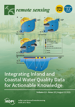
The integration of multiple sources of water quality data via data assimilation can result in a more holistic characterization of inland and coastal waters and consequently improve water resource management, yet methods for scaling water quality data across regions and beyond have emerged only recently. In this paper, data sources and existing data integration frameworks are reviewed to give an overview of the present status and identify the gaps in existing frameworks. We propose an integration framework to provide information to user communities through the Group on Earth Observations (GEO) AquaWatch Initiative. This aims to develop and build the global capacity and utility of water quality data, products, and information to support equitable and inclusive access for water resource management, policy, and decision making. View this paper
  • Issues are regarded as officially published after their release is announced to the table of contents alert mailing list .
  • You may sign up for email alerts to receive table of contents of newly released issues.
  • PDF is the official format for papers published in both, html and pdf forms. To view the papers in pdf format, click on the "PDF Full-text" link, and use the free Adobe Reader to open them.

Articles (205)

  • Article
  • Open Access
12 Citations
4,192 Views
19 Pages

A Robust SAR Speckle Tracking Workflow for Measuring and Interpreting the 3D Surface Displacement of Landslides

  • Davide Donati,
  • Bernhard Rabus,
  • Jeanine Engelbrecht,
  • Doug Stead,
  • John Clague and
  • Mirko Francioni

3 August 2021

We present a workflow for investigating large, slow-moving landslides which combines the synthetic aperture radar (SAR) technique, GIS post-processing, and airborne laser scanning (ALS), and apply it to Fels landslide in Alaska, US. First, we exploit...

  • Technical Note
  • Open Access
32 Citations
4,843 Views
11 Pages

3 August 2021

Point clouds derived using structure from motion (SfM) algorithms from unmanned aerial vehicles (UAVs) are increasingly used in civil engineering practice. This includes areas such as (vegetated) rock outcrops or faces above linear constructions (e.g...

  • Case Report
  • Open Access
1 Citations
3,092 Views
12 Pages

3 August 2021

Ground-based GNSS (Global Navigation Satellite System) reference stations lack the capacity to provide data for ocean regions with sufficient spatial-temporal resolution, limiting the detailed study of the equatorial ionization anomaly (EIA). Thus, t...

  • Article
  • Open Access
33 Citations
5,377 Views
23 Pages

3 August 2021

On 13 December 2020, Etna volcano entered a new eruptive phase, giving rise to a number of paroxysmal episodes involving increased Strombolian activity from the summit craters, lava fountains feeding several-km high eruptive columns and ash plumes, a...

  • Article
  • Open Access
45 Citations
6,167 Views
24 Pages

3 August 2021

Remote sensing change detection (RSCD) is an important yet challenging task in Earth observation. The booming development of convolutional neural networks (CNNs) in computer vision raises new possibilities for RSCD, and many recent RSCD methods have...

  • Technical Note
  • Open Access
4 Citations
3,723 Views
18 Pages

Comparisons of Satellite and Modeled Surface Temperature and Chlorophyll Concentrations in the Baltic Sea with In Situ Data

  • Malgorzata Stramska,
  • Marta Konik,
  • Paulina Aniskiewicz,
  • Jaromir Jakacki and
  • Miroslaw Darecki

3 August 2021

Among the most frequently used satellite data are surface chlorophyll concentration (Chl) and temperature (SST). These data can be degraded in some coastal areas, for example, in the Baltic Sea. Other popular sources of data are reanalysis models. Be...

  • Article
  • Open Access
14 Citations
3,676 Views
13 Pages

Space-Time Machine Learning Models to Analyze COVID-19 Pandemic Lockdown Effects on Aerosol Optical Depth over Europe

  • Saleem Ibrahim,
  • Martin Landa,
  • Ondřej Pešek,
  • Karel Pavelka and
  • Lena Halounova

2 August 2021

The recent COVID-19 pandemic affected various aspects of life. Several studies established the consequences of pandemic lockdown on air quality using satellite remote sensing. However, such studies have limitations, including low spatial resolution o...

  • Article
  • Open Access
29 Citations
3,807 Views
20 Pages

2 August 2021

Automatic target recognition (ATR) in synthetic aperture radar (SAR) images has been widely used in civilian and military fields. Traditional model-based methods and template matching methods do not work well under extended operating conditions (EOCs...

  • Article
  • Open Access
17 Citations
4,076 Views
24 Pages

Influence of Wind-Induced Effects on Laser Disdrometer Measurements: Analysis and Compensation Strategies

  • Vincenzo Capozzi,
  • Clizia Annella,
  • Mario Montopoli,
  • Elisa Adirosi,
  • Giannetta Fusco and
  • Giorgio Budillon

2 August 2021

Nowadays, laser disdrometers constitute a very appealing tool for measuring surface precipitation properties, by virtue of their capability to estimate not only the rainfall amount and intensity, but also the number, the size and the velocity of fall...

  • Article
  • Open Access
35 Citations
8,327 Views
19 Pages

2 August 2021

Shoreline change analysis is an important environmental monitoring tool for evaluating coastal exposure to erosion hazards, particularly for vulnerable habitats such as coastal wetlands where habitat loss is problematic world-wide. The increasing ava...

of 21

Get Alerted

Add your email address to receive forthcoming issues of this journal.

XFacebookLinkedIn
Remote Sens. - ISSN 2072-4292