


Climate 2025, 13(6), 111; https://doi.org/10.3390/cli13060111 - 27 May 2025
Abstract
►
Show Figures
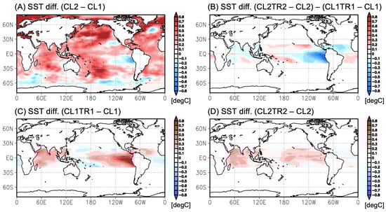
Semi-annual climate oscillations in the Western Hemisphere (20 S–35 N, 150 W–20 E) were studied via empirical orthogonal function (EOF) eigenvector loading patterns and principal component time scores from 1980 to 2023. The spatial loading maximum for 850 hPa zonal wind extended from
[...] Read more.
Semi-annual climate oscillations in the Western Hemisphere (20 S–35 N, 150 W–20 E) were studied via empirical orthogonal function (EOF) eigenvector loading patterns and principal component time scores from 1980 to 2023. The spatial loading maximum for 850 hPa zonal wind extended from the north Atlantic to the east Pacific; channeling was evident over the southwestern Caribbean. The eigenvector loading maximum for precipitation reflected an equatorial trough, while the semi-annual SST formed a dipole with loading maxima in upwelling zones off Angola (10 E) and Peru (80 W). Weakened Caribbean trade winds and strengthened tropical convection correlated with a warm Atlantic/cool Pacific pattern (R = 0.46). Wavelet spectral analysis of principal component time scores found a persistent 6-month rhythm disrupted only by major El Nino Southern Oscillation events and anomalous mid-latitude conditions associated with negative-phase Arctic Oscillation. Historical climatologies revealed that 6-month cycles of wind, precipitation, and sea temperature were tightly coupled in the Western Hemisphere by heat surplus in the equatorial ocean diffused by meridional overturning Hadley cells. External forcing emerged in early 2010 when warm anomalies over Canada diverted the subtropical jet, suppressing subtropical trade winds and evaporative cooling and intensifying the equatorial trough across the Western Hemisphere. Climatic trends of increased jet-stream instability suggest that the semi-annual amplitude may grow over time.
Full article

Figure 1


